stoughton road revitalization project - madison,...
TRANSCRIPT

Stoughton Road Revitalization ProjectCity of Madison, Wisconsin
March 14, 2008
Prepared for:
The Stoughton Road Revitalization Project Group (SRRP) and the City of
Madison, Wisconsin
Prepared by:
Cuningham Group Architecture, P.A.
Meyer Mohaddes Associates, Inc.

Stoughton Road Revitalization ProjectCity of Madison, Wisconsin
Stoughton Road Revitalization Project Group Members:Neighborhood & Business Representatives Fred Arnold, Project Chair; Elvehjem Neighborhood Jim Polewski, Project Vice-Chair; Elvehjem Neighborhood Tonya Hamilton-Nisbet, Project Secretary; East Buckeye Neighborhood Jim Roloff , Project Treasurer; Glendale Neighborhood Sandie Custer, Business Liaison & Glendale Neighborhood Chris Dyson, Glendale Neighborhood Tim Saterfi eld, Lake Edge NeighborhoodCity of Madison Alderpersons Judy Compton, City of Madison Alderperson, 16th District Larry Palm, City of Madison Alderperson, 15th District Lauren Cnare, City of Madison Alderperson, 3rd DistrictDane County Supervisors Tom Stoebig, Dane County Supervisor, 17th District Dave DeFelice, Dane County Supervisor, 16th DistrictCity of Madison Planning Divison Staff Liaison Rebecca S. Cnare, ASLA, Urban Design Planner, City of Madison Planning Division
City of Madison Staff :William Fruhling, Planning DivisionMichael Waidelich, Planning DivisionRebecca Cnare, Planning DivisionArchie Nicolette, Planning DivisionLinda Horvath, Planning DivisionRick Roll, Planning DivisionBrian Grady, Planning DivisionTim Parks, Planning DivisionKevin Firchow, Planning DivisionTim Sobota, Metro Transit
Bill Bauer, Parks Division Matthew Mikolajewski, Offi ce of Business ResourcesMichael Gay, Offi ce of Business ResourcesPeggy Yessa, Offi ce of Business ResourcesJoe Gromacki, Economic Development Robert McDonald, Transportation Planning BoardDavid Dryer, Traffi c EngineeringDan McCormick, Traffi c EngineeringRob Phillips, City EngineeringJoel Plant, Mayor’s Offi ce
The Stoughton Road Revitalization Project Group funded this project through the following fi nancial contributions and awarded grants:Neighborhood Association DonationsIndividual Financial ContributionsSouth Stoughton Road Business DonationsCity of Madison Neighborhood GrantCity of Madison TID 24 Preliminary Planning FundsDane County BUILD GrantWisconsin Department of Transportation (WisDOT)
City of Madison-Department of Planning and Community and Economic Development:Mark A. Olinger, Planning and Community and Economic Development DirectorBrad Murphy, Planning Division Director
Additional technical information about the WisDOT US Highway 51 Corridor study was provided by:Gerry Schmitt, KL EngineeringAdam Clayton, Wisconsin Department of Transportation
Adopted by the City of Madison Common Council Date:_______________ Resolution :_________ Legislative File ID :______
Acknowledgements

Table of Contents
1. IntroductionTh e SRRP Plan
Stakeholders Purpose of the SRRP Plan Plan Boundaries SRRP Vision Principles & Goals Two Plans Plan Implementation
2. Planning ProcessPublic Participation
Existing Plans & Policies
3. AnalysisStudy Area
Existing Conditions Urban Systems Natural Systems Transportation Systems Land Use
4. Development Areas Corridor Image & Identity
Development Area Selection Proposed Land Use Classifi cations
4a. Garden Development Area4b. Grid Development Area 4c. Gateway Development Area
For Each Development Area:
Identity Placemaking Community Connections Stoughton Road & WisDOT Strategic Phasing Land Use Block Guidelines Building Types Landscape Types
5. Implementation Plan Adoption & Process
City of Madison Planning Process Implementation Tools & Strategies Short-Term Implementation Medium-Term Implementation Long-Term Implementation Continued Implementation Eff orts
Executive Summary Available Upon Request
Table of Contents
Table of Contents
Pages 5-11 Th e SRRP Plan
Stakeholders Purpose of the SRRP Plan Plan Boundaries SRRP Vision Principles & Goals Two Plans Plan Implementation
Pages 12-16Public Participation
Existing Plans & Policies
Pages 17-30 Study Area
Existing Conditions Urban Systems Natural Systems Transportation Systems Land Use
Pages 31-46 Corridor Image & Identity
Development Area Selection Proposed Land Use Classifi cations
Pages 37-48Pages 49-62 Pages 63-80
For Each Development Area:
Identity Placemaking Community Connections Stoughton Road & WisDOT Strategic Phasing Land Use Block Guidelines Building Types Landscape Types
Pages 81-101 Plan Adoption & Process
City of Madison Planning Process Implementation Tools & Strategies Short-Term Implementation Medium-Term Implementation Long-Term Implementation Continued Implementation Eff orts
1. Introduction
The SRRP Plan StakeholdersPurpose of the SRRP PlanPlan Boundaries SRRP VisionPrinciples & GoalsTwo Plans Plan Implementation

6
The SRRP Plan
Stoughton Road connects the places within Madison’s East Side, an area of established neighborhoods, successful businesses, and emerging opportunities. Here, Stoughton Road acts as a local street, functions as a state highway, and is a visual symbol of Madison’s growth and change.
Neighbors and businesses view Stoughton Road as the “main street” of the community – a community of treasured parks, national corporations, small businesses, great schools, signifi cant natural features, and major initiatives like the Wisconsin BioAg Gateway Campus and the Royster Clark Special Area Planning Project.
Th is Plan, the Stoughton Road Revitalization Project (SRRP) Plan, is organized around the strengths and assets of the Stoughton Road corridor: vital neighborhoods, engaged businesses, natural qualities, strong parks, and areas of opportunity. Th is Plan recognizes the incremental nature of growth in urban areas. Realization of the Plan’s vision will require collective resources and collaborative eff orts. Residents, employers,
and visitors all contribute to the vibrancy of the East Side, and help foster a sense of community to provide future generations a welcoming place to call home.
Th is Plan encourages progressive growth along the corridor. Growth will deliver new housing, employment, retail, and commercial services for residents and visitors to the East Side. Th e future corridor will present a high quality, aesthetically pleasing image to all who use Stoughton Road. It will become a memorable gateway to Madison and front door to the East Side. Th rough broad participation, a common vision, and appropriate plans, the area’s strengths will fl ourish.
Th ree guiding elements are necessary to help make this happen:
Adopt a shared vision that enhances the corridor’s strengths, eliminates its weaknesses, and capitalizes on its opportunities.
Apply the shared vision through collaborative eff orts among public and private stakeholders.
Realize improvements incrementally; some may be made within the next year and others may take ten years or more.
•
•
•
Project Setting: Neighbors and businesses view Stoughton Road as the community’s “main street.” Th is aerial photograph overlooks the Buckeye Road intersection with South Stoughton Road, just behind Acewood Park and Pond. Lake Monona is on the far right horizon, and Lake Waubesa is on the far left horizon.
1. Introduction
Buckeye Road
Acewood Pond
North
Stoughton Road

7
Project Setting: Stoughton Road can become a memorable gateway to Madison and a front door to the East Side. Th is view looks north from the Stoughton Road and East Broadway intersection. Farm & Fleet, along with other commercial uses, is near the top left of the photograph.
Stakeholders
The SRRP GroupIn 2005, a group of residents, business contacts and elected offi cials, representing varied links to over 25,000 city residents, eight neighborhood associations, and many local businesses, started meeting to discuss the changing nature of South Stoughton Road. Th is grassroots neighborhood eff ort began the process to create a new vision to help guide future growth and development along the corridor. Th is group recognized that the East Side is home—and Stoughton Road is the way home—for everyone living and working in East Madison. Stoughton Road is a highly visible corridor and is considered a valuable asset for East Side neighborhoods. Th is informal group evolved into the “SRRP Group,” and continues to be the lead organizing force of this planning project.
SRRP Group MembersSeven East Side residents, neighborhood association members and business representatives.
Th ree City of Madison Alderpersons.
Two Dane County Supervisors.
Project Support & FundingTh e Plan has progressed with support from the Madison Mayor, the Dane County Executive, State Legislators representing the area, and the Wisconsin Department of Transportation (WisDOT). Th e City of Madison Planning Division guides the process. Funding and support of this planning process was provided by:
Private donations from Neighborhood Associations, individuals, business and property owners.
Dane County: Better Urban Infi ll Development (BUILD) Grant.
City of Madison: Neighborhood Planning Grant.
WisDOT: funding for public participation.
City of Madison Department of Planning and Community and Economic Development Project Management.
•
•
•
•
•
•
•
•
1. Introduction
East Broadway
Pfl aum Road
North
Sto
ug
hto
n R
oa
d

8
Purpose of the SRRP Plan
Historically, U.S. Highway 51, known in Madison as Stoughton Road, was a major north-south transportation route that crossed six states, and ran for over 1200 miles from Hurley, Wisconsin, to New Orleans, Louisiana. Highway 51 crossed Historic Route 66 in Bloomington, Illinois, and still wanders directly past Graceland Mansion in Memphis, Tennessee.
Currently, in Illinois and Wisconsin, much of U.S. Highway 51 is overlapped by Interstate 39. Here, in Dane County, U.S. Highway 51 is still a separate road, with Interstate 39 located just over a mile to the east. Because of this proximity, the section of Highway 51 located in Dane County acts as more of a regional and local route.
Stoughton Road’s transition from part of a national route to more of a local road will continue to evolve as redevelopment occurs and as Madison grows. Over time, the nature of traffi c fl ow and land use along the corridor will also change.
Th e purpose of the SRRP Plan is to establish land use and development guidelines for the corridor and adjacent areas to help guide this change. Th e Plan guides the development and enhancement of sustainable neighborhoods and encourages a welcoming gateway impression and cohesive corridor identity.
Recent developer interest and land use changes proposed by the City of Madison’s Comprehensive Plan reinforce the need for a plan that avoids responding to development on a parcel-by-parcel basis. Th is Plan addresses urban design issues at both the site-specifi c neighborhood level and context-sensitive corridor level.
Th is Plan emphasizes Stoughton Road’s strategic position on the city’s growing East Side and highlights its role as a neighborhood-serving corridor. Th e long-term success of Madison’s East Side is tied in large part to the quality of the Stoughton Road corridor.
Plan Boundaries
Th e general SRRP Plan boundaries extend along the South Stoughton Road (U.S. Highway 51) corridor between Wisconsin State Highway 30 on the north and U.S. Highways 12 & 18 on the south.
1. Introduction
SRRP Plan: Th e study area extends from Highway 30 on the north to Highways 12 & 18 on the south.
North
I-9
0 &
I-3
9
Highway 30
US Highway 12 -18
Milwaukee Street
Cottage Grove Road
Buckeye Road
Femrite Drive
Pfl aum Road
East Broadway
Lake
MononaS
tou
gh
ton
Ro
ad

9
SRRP Vision
Th e vision that the SRRP Group fi rst developed in 2005 has remained constant:
Provide a gateway to East Madison.
Establish a positive and welcoming image.
Encourage diversity in business and commercial enterprises.
Eliminate out-sized and over-scaled advertising.
Incorporate public art.
Generate safe access to neighborhood-oriented businesses.
Encourage alternative transportation modes.
Refl ect inviting and attractive design guidelines.
Promote mixed business/residential uses.
Encourage imaginative and sustainable green spaces.
•
•
•
•
•
•
•
•
•
•
Principles & Goals
Recommendations, development concepts, and design guidelines throughout this plan relate to several principles and goals used to help implement the SRRP Vision.
Principles
Foster a sense of place
“Th is is the East Side of Madison.”
Build on existing strengths
Start with what is valued—design new buildings, streets, and open spaces to fi t their surroundings.
Provide clarity and predictability
Integrate a level of confi dence that will foster investment and guide redevelopment.
Facilitate a collaborative process
Promote and address change through collaborative eff orts with public and private stakeholders.
Promote a balanced point of view
Balance regional and local access and serve multiple users.
Goals
Establish a land use and development concept that supports incremental change.
Recognize and restore the local ecology.
Create a prominent public realm of parks and open spaces.
Enhance the corridor landscape and visual identity at the entrance and edges of the corridor.
Create compact, connected, and walkable development patterns.
Encourage a mix of uses and variety of building types.
Provide a connected street and movement network.
Communicate with WisDOT and advocate for a transportation plan that balances connectivity and access with mobility and capacity.
•
•
•
•
•
•
•
•
Existing Strengths: Neighbors and businesses value attractive buildings and open spaces that fi t their surroundings.
1. Introduction

10
development, and corridor aesthetics is essential for the future success of the East Side.
Th e SRRP Plan has two main functions. Th e fi rst and most important function is to help the community illustrate a future vision for the corridor regarding land use, urban design, natural systems, and economic growth and development opportunity. Th e second focus of the Plan is to consider the proposed WisDOT Corridor Study alternatives, and to suggest how reconstructed traffi c fl ow on Stoughton Road can align with the SRRP Group and stakeholder vision.
Both the SRRP Plan and the WisDOT Corridor Study recognize that growth, development, and change will continue, and so will the demand for adequate, safe, and convenient streets and highways.
Two Plans
Th e existence of two separate planning studies for the Stoughton Road corridor caused confusion during the planning process. Th e Wisconsin Department of Transportation (WisDOT) is undergoing a transportation improvement project plan, Th e Stoughton Road Corridor Study, for the U.S. Highway 51 corridor extending north and south of Madison. Th e Stoughton Road Revitalization Project Plan is a neighborhood based, land use, urban design, and economic development opportunity analysis plan that comes from a grassroots neighborhood eff ort looking to fi nd a cohesive vision for the Stoughton Road corridor.
Th e two studies are related, but each focuses on diff erent attributes of the corridor. Th ere is some membership overlap between the WisDOT Policy Advisory Committee and the SRRP Group. Th is overlap allowed the SRRP Group to have continued communication with the WisDOT staff and project planners.
WisDOT Stoughton Road Corridor StudyTh rough an extensive analytical planning process, WisDOT determined future needs for Stoughton Road. Over the next few decades, Stoughton Road must accommodate additional safety and capacity improvements. Th e WisDOT Corridor Study is a physical plan that considers diff erent construction alternatives to improve traffi c fl ow, safety, and highway capacity.
Th e WisDOT Corridor Study is a continuing eff ort that analyzes various construction alternatives with respect to costs, feasibility, environmental and social impacts, and functionality.
SRRP PlanTh e SRRP Group recognized the need to have a community vision and dialog to coincide with the larger WisDOT plan. In conjunction with the recommendations focused on functional highway improvements, a study of adjacent land uses,
Two Plans: Th e WisDOT Corridor Study is comprised of three sections, North (red), Central (blue), and South (yellow). More information on the WisDOT project, including current plans and designs, is located here:www.dot.wisconsin.gov/projects/d1/us51corridor/index.htm.
Th e SRRP Plan discusses land use, development opportunities, design guidelines, and transportation ideas for only a part of the Central Segment between Highway 30 on the north and U.S. Highways 12 & 18 on the south (black box).
1. Introduction
North

11
Cottage Grove Road
North
Buckeye Road
US Hwys 12 & 18
Sto
ug
hto
n R
oa
d
Milwaukee Street
Cottage Grove Road
Buckeye Road
US Highway 12 18
Sto
ug
hto
n R
oa
d
North
Milwaukee Street
Pfl aum Road
Femrite Drive
Plan Implementation
Th is Plan will be adopted as part of the City of Madison Comprehensive Plan. While the Comprehensive Plan establishes broad city policy, the SRRP Plan guides specifi c development. Th e SRRP Plan’s vision, principles, and guidelines apply only to this corridor and address issues particular to Madison’s East Side.
Th e Plan promotes responsible, sustainable, and incremental change. Each incremental change anticipates and prepares for long-term investments in public infrastructure, open spaces, and new buildings.
SRRP Plan recommendations will require actions and activities by the Madison Common Council, Plan Commission, and Urban Design Commission, and will require coordination with the Madison Comprehensive Plan, Zoning Code, Sign Code, and other Neighborhood and Special Area Plans.
Successful implementation, whether immediate or long-term in scope, relies on a collaborative eff ort among public and private stakeholders. Th e SRRP Plan process began as a grassroots partnership led by the neighborhoods in conjunction with public entities. Implementation should foster public-private partnerships, raise investor confi dence, and inspire new ideas to fulfi ll the shared vision of a promising future for the East Side.
1. Introduction
Plan Implementation: Th e SRRP Plan works in conjunction with the future land use (left) and future redevelopment areas (center) identifi ed in the City of Madison Comprehensive Plan. Th e SRRP Plan recognizes existing businesses (right) as important parts of the Stoughton Road corridor, now and in the future.
Cottage Grove Road
Buckeye Road
US Highway 12-18
Sto
ug
hto
n R
oa
d
North
Milwaukee Street
Pfl aum Road
Femrite Drive


2. Planning Process
Public Participation Existing Plans & Policies

14
Public Participation
Public input and public engagement are the foundation of this Plan. In response to uncertainty about the corridor’s physical and functional future, the active citizens and representatives of the SRRP Group brought together State, County, and City offi cials to be actively involved in the planning process. Th e SRRP Group also spearheaded fund-raising eff orts for the project, actively promoted it in the neighborhoods, provided strategic direction to the planning consultant, acted as a conduit to the community, and served as ambassadors of the process. Th is wide support enabled the Plan to be a consensus vision that promotes both short-term and long-term visions and changes to the properties along Stoughton Road on Madison’s East Side.
Who? Th e consultant team engaged the public though a variety of methods, including facilitating multiple focus groups, monthly SRRP Group meetings, open houses, and four large public meetings. More than 300 people participated at these various events, and many attended more than one meeting.
Th e SRRP Group and City Staff actively recruited residents, business and property owners, and
other interested citizens to attend one or more large public meetings and focus groups. Due to the large interest in both the SRRP Plan and the WisDOT Corridor Study, mailings, newspaper advertisements, and e-mail lists were used to encourage individuals with concerns about the corridor to take part in the process.
How?Th e SRRP organized in June 2005 to raise funds needed for a Corridor Study and Plan. Once fundraising was complete and planning consultants chosen, the SRRP planning process began in early 2007.
Phase 1: Initial data gathering included a photo inventory, site analysis, focus group meetings, and the fi rst of four public meetings. Th e purpose of the initial focus groups and public meetings was to gather information from diff erent groups on the strengths, weaknesses, and opportunities along the corridor.
Phase 2: Th roughout the spring and summer, the planning consultant team met regularly with the SRRP Group and City Staff , reconvened focus groups, and conducted additional public meetings. During these meetings, the consultant team shared ideas and gathered feedback. Each public meeting consisted of a presentation as well as a forum for public input. Focus groups concentrated on specifi c issues, such as neighborhood interaction with the corridor and business district, business retention and development, and transportation issues.
Phase 3: Initial recommendations, design guidelines and development concepts were shared with focus groups and at a large public meeting. Early drafts of the Plan were posted on the internet and shared at several open houses, hosted by the Pinney Branch Library, to acquire additional citizen input.
Phase 1:Learning
Phase 2:Alternatives
Phase 3:Recommendations
Apr 2007
Dec 2007
Initial Information
1
Existing Conditions
2
Options & Ideas
4
Development Areas
5
Draft Plan
7
Plans & Guidelines
6
Public Participation: Focus groups, and public meetings, and SRRP Group Meetings served as forums for sharing information, gathering feedback, and hearing participants’ ideas.
2. Planning Process

15
What?An important part of Phase 1 was a colored sticker “Dot-Mocracy” exercise. Participants at all meetings and focus groups in Phase 1 identifi ed on the map where the strengths, weaknesses, and opportunities were along the corridor. Th is information is valuable because it indicates what strengths should be built upon, supported, and leveraged, and where change should occur.
Strengthsincluded the wide range of diff erent employment opportunities, as well as strong adjacent neighborhoods and neighborhood associations.
Weaknessesfocused on the lack of neighborhood services, under used properties, and the general appearance and attractiveness of the corridor.
Opportunitiesfocused on the transition to growing employment sectors on the southern end, and better neighborhood connections on the northern end of the corridor.
2. Planning Process
Strengths: Range of business typesRange of employment opportunitiesWoodman’s Grocery and Farm and FleetDean ClinicRegional accessNatural featuresNeighborhoods
Weaknesses: Appearance of Stoughton RoadLack of neighborhood servicesLack of business support servicesIntersections along Stoughton RoadUnder-used propertiesCongested arterialsUnattractive properties
Opportunities: Gateway to BioAg industry areaProperty aesthetics Buckeye Road intersectionPfl aum Road intersectionNew uses at Beltline sitesStoughton Road frontage aestheticsUnder-used land at Cottage Grove Road
Dean
Clinic
Farm &
Fleet
Woodman’s
Edna
Taylor
wetlands
North
intersections
under
used used
intersections
North
new uses
North
intersections
intersections

16
Existing Plans & Policies
Comprehensive PlanMadison’s Comprehensive Plan sets broad policy for land use and development patterns along the Stoughton Road corridor. It focuses growth and change along the corridors, not in the neighborhoods. It also designates several sites along the corridor for Transit-Oriented Development (TOD), including the intersections of Stoughton Road, Buckeye Road, and Pfl aum Road, as well as sites along Cottage Grove Road.
TOD sites are characterized by a compact, mixed-use development pattern that focuses the highest development densities and intensities in proximity to transit stops. TOD designations of that plan suggests signifi cant changes to the predominantly low density development pattern across much of the East Side of Madison. Th ese designated
Comprehensive Plan Maps: Transit-Oriented Developments (blue stars) are located at crossroads, former industrial sites, and vacant sites.
Hiestand Neighborhood Plan: Th is plan’s recommendations relate to the corridor.
TOD sites are located either along crossroads or at former industrial and vacant sites. Madison’s Comprehensive Plan gives clear but broad policy direction for which properties on the East Side should remain industrial sites and which should be converted to mixed-use. In particular the Comprehensive Plan identifi es the Broadway area as the area for mixed-use commercial.
Neighborhood PlansSome of the neighborhoods in the area have neighborhood plans. Th ese plans vary in scope. However, most address housing issues and other issues that are relatively specifi c to the neighborhood. A plan was recently adopted for the Hiestand Neighborhood, located between Highway 30 and Milwaukee Street. Th e SRRP Plan supports and encourages the implementation of recommendations from adjacent neighborhood plans whenever possible.
North
Highway 30
US Highways 12-18
North
Milwaukee Street
Cottage Grove Road
Buckeye Road
Pfl aum Road
Femrite Drive
Highway 30
US Highways 12-18
North
Milwaukee Street
Cottage Grove Road
Buckeye Road
Pfl aum Road
Femrite Drive
2. Planning Process

3. Analysis
Study Area Existing Conditions Urban Systems Natural Systems Transportation Systems Land Use

18
Study Area
Stoughton Road is the major north-south transportation corridor through Madison’s East Side. It provides local and regional service to the area and off ers access to the variety of viable, established neighborhoods, businesses, services, and places of employment that comprise the East Side.
Th e Stoughton Road corridor is a segment of U.S. Highway 51, which extends north to south from Hurley, Wisconsin, to New Orleans, Louisiana. Interstate 39 overlaps many sections of Highway 51 in Wisconsin and Illinois, and is located just east of this study corridor. Due to this proximity, this segment of Stoughton Road between Wisconsin State Highway 30 and U.S. Highways 12-18 functions at regional and local levels.
Stoughton Road’s traffi c patterns and land uses respond to these demands, but in doing so often create confl icts, cause delay, and compromise safety. Both local and regional traffi c are competing for the same lanes. Th ese traffi c confl icts occur at intersections with Stoughton Road where local and regional traffi c is funneled to the same point despite having diff erent movement patterns and destinations.
In addition to being the location of many traffi c crashes, the intersections aff ect surrounding neighborhoods, commercial areas, and employment centers. Th ese areas experience traffi c-related access and wayfi nding challenges, cut-through traffi c, confl icting land uses, poorly placed buildings and parking areas, and deteriorating building and property conditions.
3. Analysis
City of Madison Context Map: Stoughton Road (red) is the major north-south route through Madison’s East Side.
To Sun Prairie
East Towne
Regional
Shopping
District
Dane County
Regional Airport
To Deforest, Wisconsin Dells,
Eau Claire, and Minneapolis
To Milwaukee
To Cambridge &
Watertown
To Janesville,
Rockford &
Chicago
To McFarland
& StoughtonTo Verona &
Dodgeville
Middleton
Monona
North
19
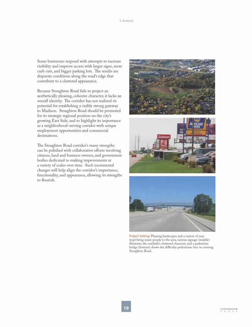
Some businesses respond with attempts to increase visibility and improve access with larger signs, more curb cuts, and bigger parking lots. Th e results are disparate conditions along the road’s edge that contribute to a cluttered appearance.
Because Stoughton Road fails to project an aesthetically pleasing, cohesive character, it lacks an overall identity. Th e corridor has not realized its potential for establishing a visibly strong gateway to Madison. Stoughton Road should be promoted for its strategic regional position on the city’s growing East Side, and to highlight its importance as a neighborhood-serving corridor with unique employment opportunities and commercial destinations.
Th e Stoughton Road corridor’s many strengths can be polished with collaborative eff orts involving citizens, land and business owners, and government bodies dedicated to making improvements at a variety of scales over time. Such incremental changes will help align the corridor’s importance, functionality, and appearance, allowing its strengths to fl ourish.
Project Setting: Pleasing landscapes and a variety of uses (top) bring many people to the area, various signage (middle) illustrates the roadside’s cluttered character, and a pedestrian bridge (bottom) shows the diffi culty pedestrians face in crossing Stoughton Road.
3. Analysis

20
Existing Conditions
A Photographic Inventory A photo sampling illustrates some key issues for the future of the corridor. Th ese issues helped shape the goals and vision of the SRRP Group.
Rural Cross Section on Highway 51While the city has grown around the original “East Beltline,” Stoughton Road remains a highway with a rural cross section. Th is cross section is exemplifi ed by limited curb, gutter, and sidewalk along the frontage roads, a large median drainage swale, and few trees or other vegetation. As the East Side continues to redevelop and WisDOT explores the expansion of the roadway, there may be opportunities to add trees and other more urban amenities within the highway right-of-way.
Signs & Billboards Large commercial signs and billboards are present throughout the corridor. As new development occurs, there may be an opportunity to remove some billboards, create a more cohesive wayfi nding system, and encourage more attractive and eff ective commercial signs.
Employment & IndustryOne of the positive aspects of Stoughton Road noted by participants in the public meetings was the variety of employment opportunities along the corridor. Th e Southeast Business District and BioAg Gateway Campus can provide the stability and opportunity necessary to promote new growth and development along the corridor.
Land Use Confl ictsMany areas along the corridor have old town zoning classifi cations that were not updated upon being annexed by the city. Th ese areas, found at several key neighborhood gateways, often suff er from being underutilized. While there is a strong employment base along Stoughton Road, storage of automobiles, trucks, and other industrial materials continue to cause confl ict between neighborhood, commercial, and industrial uses. Underutilized Land: Underutilized and vacant land parcels are
prime examples of potential redevelopment opportunities.
Rural Cross Section: Stoughton Road has a wide cross section typical of rural settings, with limited curb and gutter and a large central swale for drainage and lane separation.
Signs & Billboards: Signs and billboards along the highway create a cacophony of visual clutter.
Employment Opportunities: Th ere are many successful and stable employers in the corridor. Th is strength should be used to generate additional development and growth opportunities.
3. Analysis

21
Urban Systems
Photographs of the existing corridor document the conditions that fi rst prompted this planning study. Th ese photographs also reveal how all of these existing conditions interact along the length of the corridor. By studying these interactions and relationships, this SRRP Plan proposes policy, land use and development recommendations for the corridor.
Th e relationships between these conditions demonstrate that the city is comprised of overlapping political, land use, open space, streets, and building systems. Each system or layer reveals important information about how the City operates and functions, and each system aff ects the others, creating a complex urban organism. For example, the neighborhood structure and old zoning classifi cations resulting from the annexation process of the past 60 years, aff ect land use and development decisions that ultimately shape the transportation system.
Th e Stoughton Road corridor aff ects the larger composition of the urban systems throughout the entire city and surrounding areas. Successful interaction between these layers make cities vibrant, interesting, and prosperous. However, confl ict often occurs when these urban systems do not work together.
Th is Plan analyzes the health and integrity of these individual systems. More important than the strength of each system is how it supports and reinforces the others. Each separate layer should be individually healthy and should also work in concert with the others. One of the goals of this Plan is to create a healthier urban infrastructure by recommending appropriate changes to selected systems so that various systems work together more successfully as a whole.
Layers of the City: Th e city is comprised of multiple layers and systems that exist independently but impact each other.
3. Analysis
City Boundaries
Neighborhoods
Commercial/Industrial
Parks & Open Space
Local Streets
Regional Streets
North

22
Natural Systems
Several major natural systems exist in and around the study area. Remnants of the wetland, prairie, and meadow landscapes that once covered the area are still some of the strongest and most visible natural features there. Most recognizable changes to this landscape occurred in the fi rst half of the 20th century, when local farms converted the natural landscape to rich agricultural uses. In the last 50 years, the development community has transformed these farms into subdivisions and urban land uses. Although most original landscapes were altered, many still function as valuable amenities. Some, like Edna Taylor Conservation Park, are returning to their original functions and others, like Olbrich Gardens, serve new ones.
Th is Plan suggests using these systems as a framework, or underlying structure, for organizing future development of buildings and open spaces. Recommendations outline ways to recognize the ecological value of these systems and to make them more visually and physically accessible. As part of this framework, this Plan will look for new open space and greenway connections between neighborhoods and other urban systems.
Th e expansive wetland corridor that passes through the southern and most industrialized area are part of a larger, nearly intact natural system. Th ese
Water & Wetlands: Remnants of wetland landscapes are some of the strongest and most visible natural features in the study area. Th ough altered to meet present needs, Acewood Park and Pond (above) is part of one important area wetland system.
Natural Systems: Th e study area (top) is comprised of diff erent kinds of wetlands, gardens, parks, and open spaces (green). Th e environmental corridors present in the southern part of the study area (bottom) should dictate new development patterns.
environmental corridors provide natural boundaries and edges to development patterns and land uses. Th eir presence and location suggest areas where urban development should have a gentle impact on the surroundings, and where land uses can be intensifi ed. Th ese natural areas can also enhance the existing infrastructure, as they create a unique environment where employment and other uses can benefi t from the juxtaposition of the industrial and natural areas existing side-by-side.
3. Analysis
I-90
Femrite Drive
Cottage Grove Road
Milwaukee Street
Buckeye Road
E BroadwayUS Highway 12-18
Highway 30
Sto
ug
hto
n R
oa
d
Lake
Monona
Pfl aum Road
North

23
Transportation Systems
Regional TransportationStoughton Road was the original East Beltline. Before Madison grew eastward, the road’s primary function was to carry long distance travelers between points north and south of Madison. However, as the city grew and the interstate system was built, Stoughton Road’s role as the East Beltline diminished. Th e longer distance travel moved east to I-90, and local and regional trips became increasingly important to Stoughton Road. Stoughton Road currently provides connections to several regional routes, such as:
Interstate System: Highway 30, connect to the Badger Interchange of I-90, I-94, and I-39.
Interstate System: Highway 12 & 18 connect to I-90 and I-39.
U.S. Highway 151 at East Washington Avenue: U.S. Highway 151 connects across the entire state, southwest to northeast.
•
•
•
Stoughton Road’s Regional Role: Stoughton Road was the original East Beltline. It remains a critical transportation corridor for the East Side of Madison even though I-90 now functions as the East Beltline (top). Stoughton Road’s wide right-of-way and adjacent land use and development patterns are results of its original role.
3. Analysis
North
Since it was originally conceived of as a part of the Beltline system, Stoughton Road has few intersections, no direct access to properties, and a wide right-of-way. Th ese characteristics dictated land uses and development patterns over time.

24
WisDOT Design Concepts Th e WisDOT Corridor Study includes a large segment of U.S. Highway 51, from the Dane County line on the north to the intersection with I-90 and I-39 south of the City of Stoughton. U.S. Highway 51 is an important regional and local north-south corridor. It provides access to major employment and residential areas, serves regional traffi c to outlying communities, provides access the Dane County Regional Airport, and intersects with East Washington Avenue, Madison’s busiest east-west connection through the central business district.
Studies by WisDOT and the Metropolitan Planning Organization show that employment, housing, and traffi c along the corridor will likely double in the next 25 years. WisDOT’s goal is to address growing safety, congestion, and multi-modal access concerns by:
Identifying and implementing short-term improvements on an ongoing basis.
Identifying and evaluating eff ects of the possible longer-term improvement alternatives.
Sharing information with the community and gathering comments regarding road improvement alternatives.
Th e SRRP Plan study area is located in part of the WisDOT Study’s Central Segment. To date, WisDOT has completed a needs assessment and alternatives analysis, and has identifi ed several short-term improvements that could mitigate existing congestion problems. Th e analysis includes three alternatives: A, B, and C. As WisDOT continues the environmental impact analysis and fi nalizes recommendations, the reconstruction plan could be a combination of several diff erent alternatives along the length of the corridor.
Major construction on this project will likely begin in 15-20 years and will continue segment by segment. Due to the complex nature and large amount of traffi c at the Stoughton Road and Highway 12-18/Beltline intersection, it is likely that this will be the last segment rebuilt. Dysfunctional intersections north of it produce added congestion at this intersection, making it
•
•
•
necessary to resolve congestion issues elsewhere before facilitating less restricted traffi c movements at the Highway 12-18/Beltline intersection.
WisDOT Alternative A: Low-Build OptionIntersection capacity is added and mobility is increased without additional traffi c lanes or interchanges.
Minimal alignment improvements to occur at Milwaukee Street and Cottage Grove Road.
Frontage road intersections at Buckeye and Pfl aum Roads to be pulled away from Stoughton Road to increase the spacing between signals.
East Broadway intersection to be moved north to increase signal distance between it and U.S. Highways 12-18.
WisDOT Alternative B: Depressed Roadway Minimal improvements occur at Milwaukee Street and Cottage Grove Road.
Pfl aum Road and Buckeye Road intersections to be grade-separated from Stoughton Road, which is depressed beneath and between them.
Pfl aum and Buckeye Roads to be designed to act as one “split” interchange.
Frontage roads become one-way roads, and new “Texas U-turn style” bridges are located immediately south of Buckeye Road and immediately north of Pfl aum Road in order to separate local frontage road traffi c from regional intersection traffi c.
Free fl ow fl yover ramps are built to move traffi c to and from eastbound U.S. Highways 12-18.
WisDOT Alternative C: Freefl ow FreewayInterchanges at Buckeye Road, Pfl aum Road, and U.S. Highway 12-18 are built to accommodate free fl ow traffi c movement throughout the corridor.
Stoughton Road is depressed between Buckeye Road and Pfl aum Road.
Frontage road intersections at Buckeye Road and Pfl aum Road are pulled away from Stoughton Road to increase the spacing between signals.
Th e SRRP Plan must interact with and relate to these diff erent WisDOT traffi c alternatives in order to encourage development opportunities along the corridor.
•
•
•
•
•
•
•
•
•
•
•
•
3. Analysis

25
WisDOT Alternative A WisDOT Alternative CWisDOT Alternative B
WisDOT Alternative Concepts A, B, & C
3. Analysis
frontage roads pulled back to increase spacing for signal
Broadway is realigned with Femrite to increase signal spacing with US Hwy 12-18
Cottage Grove Road
Buckeye Road
Pfl aum Road
E Broadway
Sto
ug
hto
n R
oa
d
geometric changes to ramps increase safety
US Highway 12-18North
Stoughton Road depressed beneath Buckeye and Pfl aum Roads
triple level fl yover eliminates eastbound US Hwy 12-18 to northbound Stoughton Road from E Broadway intersection
Cottage Grove Road
Buckeye Road
E Broadway
geometric changes to ramps increase safety
Sto
ug
hto
n R
oa
d
Pfl aum Road
US Highway 12-18
fl yover
North
geometric changes to ramps increase safety
Cottage Grove Road
Buckeye Road
E Broadway
Sto
ug
hto
n R
oa
d
frontage roads pulled back to increase spacing for signal
Stoughton Road depressed beneath Buckeye and Pfl aum Roads
Pfl aum Road
triple level fl yover eliminates eastbound US Hwy 12-18 to northbound Stoughton Road from E Broadway intersection
US Highway 12-18
fl yover
North
26
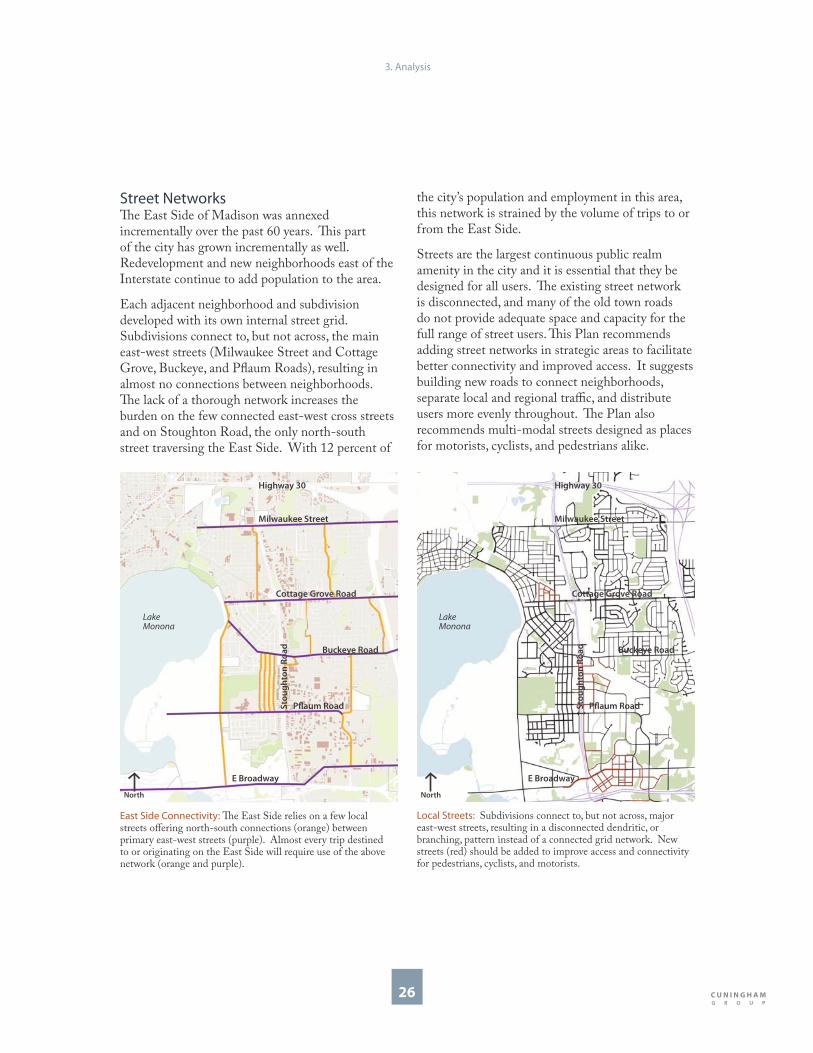
East Side Connectivity: Th e East Side relies on a few local streets off ering north-south connections (orange) between primary east-west streets (purple). Almost every trip destined to or originating on the East Side will require use of the above network (orange and purple).
the city’s population and employment in this area, this network is strained by the volume of trips to or from the East Side.
Streets are the largest continuous public realm amenity in the city and it is essential that they be designed for all users. Th e existing street network is disconnected, and many of the old town roads do not provide adequate space and capacity for the full range of street users. Th is Plan recommends adding street networks in strategic areas to facilitate better connectivity and improved access. It suggests building new roads to connect neighborhoods, separate local and regional traffi c, and distribute users more evenly throughout. Th e Plan also recommends multi-modal streets designed as places for motorists, cyclists, and pedestrians alike.
Local Streets: Subdivisions connect to, but not across, major east-west streets, resulting in a disconnected dendritic, or branching, pattern instead of a connected grid network. New streets (red) should be added to improve access and connectivity for pedestrians, cyclists, and motorists.
Street NetworksTh e East Side of Madison was annexed incrementally over the past 60 years. Th is part of the city has grown incrementally as well. Redevelopment and new neighborhoods east of the Interstate continue to add population to the area.
Each adjacent neighborhood and subdivision developed with its own internal street grid. Subdivisions connect to, but not across, the main east-west streets (Milwaukee Street and Cottage Grove, Buckeye, and Pfl aum Roads), resulting in almost no connections between neighborhoods. Th e lack of a thorough network increases the burden on the few connected east-west cross streets and on Stoughton Road, the only north-south street traversing the East Side. With 12 percent of
3. Analysis
E Broadway
Buckeye Road
Cottage Grove Road
Milwaukee Street
Sto
ug
hto
n R
oa
d
Pfl aum Road
Lake
Monona
Highway 30
North
E Broadway
Buckeye Road
Cottage Grove Road
Milwaukee Street
Sto
ug
hto
n R
oa
d
Pfl aum Road
Lake
Monona
Highway 30
North

27
Regional Trips
As a United States Highway, the corridor’s original function was to facilitate long distance travel. However, as the Interstate System developed, this segment of U.S. Highway 51 now plays an important regional traffi c role.
Regional trips begin and end outside the study area, but pass through it. Speed and mobility, not stops along the corridor, are the goals of a regional trip. Th e trip is through, not to, the area. Approximately 50 percent of Stoughton Road traffi c comes from eastbound U.S. Highway 12-18.
City Trips
As the city grew east, Stoughton Road’s function became more complicated. It was no longer a long distance transportation route and began to transition into a road with more urban functions.
City trips begin or end in the study area. East Siders use Stoughton Road to leave the area, and visitors use Stoughton Road to access the area. Each of these trips creates interchanging traffi c at either Milwaukee Street, Cottage Grove Road, Buckeye Road, Pfl aum Road, and East Broadway.
Local Trips: Today, the intersections along Stoughton Road, as well as Stoughton Road itself, are used for almost all local trips. Local trip destinations include neighborhood shops, grocery stores, parks, elementary, middle, and high schools, and general neighborhood destinations and movement between them.
City Trips: Stoughton Road, while functionally classifi ed as an arterial street, performs an secondary role operating as a collector street for East Side neighborhoods. City trip destinations include East Towne Mall Shopping District, religious institutions, Farm & Fleet, city-wide commute-to-work locations, and employment destinations.
Regional Trips: Because it was originally designed for long distance travel, Stoughton Road plays an important role in the regional network. Regional trip destinations include Dane County Regional Airport, Madison Area Technical College, adjacent municipalities like McFarland, Stoughton, and Deforest, and the interstate system.
Local Trips
Th e East Side’s incremental growth will continue to pressure the street system. Except for a few major cross streets, there is no east-west network, and the lack of major north-south routes forces many local north-south trips onto Stoughton Road. East Side residents use a complex system of neighborhood cut-throughs that put increased pressure on turning movements, intersections, and residential streets.
Local trips begin and end in the study area, and many require interaction with Stoughton Road. As a result, the corridor operates as the East Side’s main street.
3. Analysis
Sto
ug
hto
n R
oa
d
Buckeye Road
Cottage Grove Road
Milwaukee Street
Pfl aum Road
Femrite Drive
Lake
Monona
E Broadway
Highway 30
North
Sto
ug
hto
n R
oa
d
Buckeye Road
Cottage Grove Road
Milwaukee Street
Pfl aum Road
Femrite Drive
Lake
Monona
E Broadway
Highway 30
NorthNorth
Sto
ug
hto
n R
oa
d
Buckeye Road
Cottage Grove Road
Milwaukee Street
Pfl aum Road
Femrite Drive
Lake
Monona
E Broadway
Highway 30

28
Intersection Turning Movements
Because there are so few east-west connections on the East Side, almost all trips destined to or originating from the area require use of Stoughton Road and the main intersections. As a result, interchanging travel (vehicles getting on and off Stoughton Road), through travel (vehicles passing straight through without stopping) and local travel (vehicles accessing properties along the streets) all compete for space and time at the intersections.
Congestion and delay at the intersections can be reduced in two ways:
Additional connectivity to the local and regional road network: Additional connectivity would
•
provide local options to pull some of the trips out of the overburdened intersections. However, increased connections must be spaced properly as to not reduce mobility.
Separation of through trips from local trips: Grade separated intersections utilize bridges and ramps to allow through-traffi c to free-fl ow over or beneath the cross streets and limit the need for four-way intersections. Th is would remove signifi cant traffi c volume from the intersection, and allow it to function for local traffi c only.
•
Intersections: Intersections along Stoughton Road (yellow) and the cross streets process three types of high volume traffi c. Additional street networks that serve local trips would reduce congestion and intersection delay by providing alternatives routes.
Triple Convergence: Existing conditions (top) force all traffi c through the same intersection. Adding connections (bottom) and grade-separating traffi c relieves intersections of congestion.
3. Analysis
Sto
ug
hto
n R
oa
d Buckeye Road
Cottage Grove Road
Milwaukee Street
E Broadway
Pfl aum Road
Lake
Monona
North
Sto
ug
hto
n R
oa
d
cross street (typical)
local traffi c
through traffi c
interchanging traffi c
North
through traffi c
interchangingtraffi c
Sto
ug
hto
n R
oa
d
cross street (typical)
local traffi c
North

29
Land Use
Madison’s East Side is comprised of corridors, districts, and neighborhoods. Corridors are linear systems that facilitate movement of goods, people, wildlife, and transit, and are exemplifi ed by Stoughton Road and the southeast wetland systems. Districts, or areas devoted to a single use, include places like the Atlas industrial area, the retail district between Buckeye and Pfl aum Roads, and the southeast BioAg industrial and research areas. Th e corridor is also the spine that connects eight diff erent neighborhoods.
Because the East Side was once the outer part of the city, high-impact uses such as heavy manufacturing, rail-served industrial uses, and large trucking operations are located here. Th ese industrial areas formed districts that generated employment and economic development as well as demand for new housing and neighborhoods. Property was subdivided and developed into
strongly defi ned neighborhoods and districts along major corridors. Each neighborhood, district, and corridor operates as an individual, single-use zone instead of as one connected, mixed, and dynamic place. Th is Plan recommends diversifi cation of land uses to achieve the heightened variety of services and vitality of uses to protect and enhance established neighborhoods. Th is supports the Comprehensive Plan’s policy of infi ll development and further intensifi cation of existing urbanized areas. Recommendations include further intensifi cation that takes the form of “mixed-use centers” along designated corridors and redevelopment areas. Mixed-use centers are development and infi ll projects that off er a mixture of retail, employment, and housing options within a walkable area. Th ese mixed-use centers should be located near regional roadways and future transit corridors. Th eir mix of uses should serve the region as well as the East Side.
3. Analysis
Existing Corridor, District, & Neighborhood: Corridors (green areas and white roads), districts (gray and red), and neighborhoods (yellow) exist in the study area today.
I-94
I-90
Femrite Drive
Cottage Grove Road
Milwaukee Street
Buckeye Road
E Broadway
US Highway 12-18
Highway 30S
tou
gh
ton
Ro
ad
Lake
Monona
Pfl aum Road
North
Proposed Corridor, District, Neighborhood, & Center: Future development should focus on creating centers (orange) in strategic locations.
Femrite Drive
Cottage Grove Road
Milwaukee Street
Buckeye Road
E BroadwayUS Highway 12-18
Highway 30
I-94
Sto
ug
hto
n R
oa
d
I-90
Lake
Monona
Pfl aum Road
North

30
City of Madison Comprehensive Plan Land Use Map
3. Analysis
North
Existing Land Use Classifi cationsTh e land use categories in the City of Madison Comprehensive Plan form the framework for land use and urban design recommendations in the SRRP Plan.
Th e primary land uses adjacent to the corridor are Employment, Industrial, and General Commercial. Also adjacent to the corridor are low and medium density residential. Natural systems, corridors, and parks exist in this area as well.
Residential areas that back onto the highway do not show much redevelopment potential; however, there are potential areas for mixed-use development elsewhere along the corridor. Some of these are designated as Community Mixed-Use areas.
Transit-Oriented Development (TOD) is another classifi cation that shows up along the corridor. A TOD encourages compact, urban development, high-quality design, and a mix of land uses that supports multi-modal transit.
Employment, commercial, and industrial land use classifi cations provide the economic generators that are needed for continued growth along the corridor. Th is Plan is an opportunity to provide additional detailed land use recommendations that may allow commercial and employment mixed-use districts at key TOD locations and at the commercial gateways from Highway 30 and Highway 12-18. Th e TODs and commercial gateways may provide the best opportunity for economic growth and redevelopment opportunities along the corridor.
Employment
Industrial
General Commercial
Low Density Residential
Medium Density Residential
Parks & Open Space
Community Mixed-Use
Transit-Oriented Development
4. Development Areas
Corridor Image & Identity Development Area Selection Proposed Land Use Classifi cations

32
Corridor Image & Identity
Th ere are three primary Stoughton Road frontage conditions: landscape, building, and frontage road. Th ese conditions are not the result of a coordinated eff ort; instead, they are the result of incongruous properties adjacent to Stoughton Road, many of them untended rear yards of private industrial areas. Th e common perception is that much of the area is unsightly and unattractive.
Th is general conceptual diagram is the key to the successful integration of new development and landscape enhancements with the existing corridor. Th is Plan proposes using vegetation and buildings in specifi c locations to create a cohesive identity based on existing strengths.
Emphasis on New Development Emphasis on buildings, frontage roads, transportation infrastructure, and development opportunities occur at four main locations:
Th e employment district between Highway 30 and Milwaukee Street.
Th e former Royster Clark Fertilizer Plant at Cottage Grove Road. Th is area is currently the center of its own planning process.
Th e large commercial, employment, and retail center between Buckeye and Pfl aum Roads.
Th e East Broadway and Femrite intersection at the southern gateway in to the corridor.
Emphasis on Open Space
Th e emphasis on landscape, open space connections, and corridor beautifi cation occurs in several key locations:
Landscape gateways at Highway 30 at the north and Highway 12-18 at the south.
Wetland restoration and continued enhancement of Edna Taylor Conservation Park between Pfl aum Road and Femrite Drive, and wetlands and open space network opportunities throughout the southern half of the study area.
Landscape amenities between Milwaukee Street and Buckeye Road along residential areas to the west and industrial areas to the east that back up to the corridor.
•
•
•
•
•
•
• Corridor Identity: Future corridor image and identity should build on existing frontage conditions to establish a more unifi ed and recognizable image. Crossing opportunities (yellow), building and redevelopment opportunities (red), and landscape improvements and tree plantings (green) exist throughout.
Vegetation
Vegetation
Buildings
Buildings
4. Development Areas
Sto
ug
hto
n
Femrite Drive
Cottage Grove Road
Buckeye Road
E Broadway
Pfl aum Road
Milwaukee Street
Highway 30
US Highway 12 & 18North

33
Corridor Image: Existing conditions of the Stoughton Road corridor (top) include strengths that can be built upon to establish a stronger aesthetic identity (bottom). New development is emphasized at key intersections and neighborhood gateways, while enhanced landscape forms and connections are highlighted at other locations. Redevelopment opportunities and improved landscape infrastructure is shown here at the intersection of Buckeye Road and South Stoughton Road. Acewood Park and Pond is shown in the foreground.
4. Development Areas
Buckeye Road
Acewood Pond
North
Stoughton Road
Buckeye Road
Acewood Pond
North
Stoughton Road

34
Building YardsBuilding yards along Stoughton Road can be designed to enhance the area’s visual character. Trees, fences, ponds, and sculpture are some additions that can improve and unify the corridor’s appearance.
2
Gateway BuildingsBuildings at major intersections along Stoughton Road can be designed to create identifi able places. High quality buildings with strong architectural form can be gateways that anchor and create entrances to neighborhoods. 3
Public ArtHighly visible sites and locations along Stoughton Road can be designed to reinforce the area’s identity. Highway rights-of-way, building yards, and intersection open spaces are ideal locations for public art and monuments.1
Open SpacesOpen spaces can be designed to enhance the area’s character and identity, as well as to promote sustainability and a conservation-oriented aesthetic and function. Existing wetlands and parks are ideal places for designing and promoting sustainable open space development.
4
Frontage RoadsFrontage road rights-of-way along Stoughton Road can be designed to refl ect the area’s character. Street trees and decorative lights are ways to use the landscape to create a cohesive identity, while high quality building materials are ways to use architecture and buildings to do so.
5
Opportunities to Strengthen
Corridor Image & Identity
Strengthening Corridor Identity: Opportunities to reinforce the character of Stoughton Road and to strengthen the image and identity of surrounding areas exist throughout the corridor.
Surface Parking Lot Surface parking lots visible from Stoughton Road can be designed with attractive features. Hedges, fences, and tree canopies can create better edge defi nition and can contribute to a more aesthetically pleasing appearance. 6
4. Development Areas
2
16
4
5
3
4
4
4
6
3
6
4
2
2
3
2
5
5
1
6
Femrite Drive
Cottage Grove Road
Buckeye Road
Pfl aum Road
Milwaukee Street
Highway 30
E Broadway
North
Vegetation
Vegetation
Buildings
Buildings

35
Development Area Selection
Th ree areas along Stoughton Road were selected for a more detailed investigation and more specifi c recommendations. Th e Plan refers to these as Development Areas. Each Development Area is comprised of conditions representative of other areas along the corridor. Th us, lessons learned and recommendations suggested for each area are applicable to similar areas not studied in more detail.
Th e next three chapters include recommendations organized by Development Area:
Garden Development Area
Grid Development Area
Gateway Development Area
Within each Development Area chapter are recommendations for the following:
Identity
Placemaking
Community Connections
WisDOT Alternatives for Stoughton Road
Strategic Phasing
Land Use
Block Guidelines
Building Types
Landscape Types
Implementation recommendations for this Plan are located in the fi nal chapter.
•
•
•
•
•
•
•
•
•
•
•
•
Development Areas: Th e three Development Areas include the Garden (1), Grid (2), and Gateway (3).
4. Development Areas
Garden
1
Grid
2
Gateway
3
Cottage Grove Road
Buckeye Road
Pfl aum Road
Milwaukee Street
Sto
ug
hto
n R
oa
d
Highway 30
US Highway 12-18
E Broadway
Femrite Drive
Lake
Monona
North

36
Proposed Land Use Classifi cations
Th e proposed land use changes are minimal and are concentrated at intersections and at development area opportunities. Many areas along the corridor remain consistent with the 2005 City of Madison Comprehensive Plan.
Proposed corridor land uses include: Employment: Industrial: General Commercial: Low-Density Residential: Medium-Density Residential: Park and Open Space: Community Mixed-Use (CMU) Neighborhood Mixed-Use (NMU)
Th e Blue asterisk denotes a conceptual locations for: Transit Oriented Development (TOD)
A TOD encourages compact, urban development, high-quality design, and a mix of land uses that supports multi-modal transit.
Proposed Land Use ChangesMore detail about these proposed changes and land use guidelines can be found in the more specifi c Garden, Grid, and Gateway Development Areas sections.
Proposed Land Use Changes
4. Development Areas
North
From General Commercial to Community Mixed-Use (CMU): Th is area should emphasize employment and commercial uses, with limited residential on upper fl oors only.
1
From General Commercial to Community Mixed-Use (CMU): Th ese areas should transition residential uses back into the neighborhood and support a gateway neighborhood entrance that includes commercial uses.
2
From General Commercial to Open Space with adjacent Neighborhood Mixed-Use (NMU): Th is land use should change only upon completion of the Hob Street connection to the frontage road. Until this connection is realized, the area should remain General Commercial.
3
Mixed-Use Business District: Th ese areas should have similar characteristics as the CMU areas to the north, but without the residential component. Employment and Employment Services should mix with the General Commercial Uses in this area; Improved retail and service uses can create a gateway and support adjacent employment uses. Th is area should provide a gateway into the industrial and BioAg districts to the East.
4
3
4
4
2
1
2

4a. Garden Development Area
Identity Placemaking Community ConnectionsStoughton Road & WisDOT Strategic Phasing Land Use Block Guidelines Building Types Landscape Types

38
Identity
Th e Garden Development Area is located just south of the Highway 30 and Stoughton Road intersection, a major entry point into Madison for Milwaukee visitors. Th us, it is in a position to become a gateway to Madison’s East Side, including neighborhoods and businesses along the Stoughton Road corridor. Stoughton Road and its intersections are primarily above grade here. Its variable frontage is comprised of vegetation, commercial buildings, and residential yards.
Th is Development Area and its surroundings are characterized by large landscape features such as wetlands and corporate lawns, and large signature buildings like the American Family Insurance and WPS buildings.
Th is area also has a large group of land parcels that remain in the Town of Blooming Grove. Th is “town island” is characterized by a small business district, multi-family residential buildings, and some single family homes. Within the SRRP Plan area, all Town of Blooming Grove properties will offi cially be annexed to the City if Madison on November 1, 2027. Some properties may be annexed earlier upon petition by property owners and approval by the Town and the City.
Since the open space and wetlands dominate the landscape of this area, this Plan takes the opportunity to recommend prioritizing the landscape by complementing it with future
Existing Conditions: Th e Garden Development Area is characterized by a variety of landscapes and a few signature buildings. Large corporate buildings (1) are the primary building type. Decorative plantings (2) enhance the intersection of Stoughton Road and Highway 30. Th e frontage along Stoughton Road is comprised of vegetation, commercial buildings, and a residential yards.
1 2
development. Th is area also provides an opportunity to have employment functions coexist with wetlands and open space. Th is proximity may encourage opportunities for sustainable projects and development along the corridor. Th e name Garden refl ects this focus.
Area strengths include visibility, gateway location, and natural features. Weaknesses are a lack of cohesive identity and a disconnected relationship with its context because of Stoughton Road’s above grade condition, and the length of the Town of Blooming Grove’s Cooperative Agreement with the City of Madison.
Garden Development Area: Th e Garden Development Area is located at the north end of the study area, and includes properties on both sides of Stoughton Road between Highway 30 and Milwaukee Street.
4a. Garden Development Area
Milwaukee Street
Highway 30
Sto
ug
hto
n R
oa
d
Town of
Blooming
GrovePost
Offi ce
American
Family
Insurance
21
North

39
Hiestand
Park
Garden Development Area Conceptual Plan: Th e Plan suggests visually connecting both sides of Stoughton Road visually by expanding existing wetland and trail systems and planting grids of trees throughout lawns and parking lots. Th is large landscape gesture highlights the important landscapes in the area, helps establish an attractive gateway to the East Side, and reinforces a strong identity for Stoughton Road.
Sto
ug
hto
n R
oa
d
American
Family
Insurance
Milwaukee Street
Highway 30
Post
Offi ce
wetlands
Natural Feature East of the Corridor: Hiestand Conservation Woods has large red oaks that dominate this wooded park and trail system. Trilliums cover the forest fl oor with a blanket of white in May. Hiestand Park features a disc-golf course, soccer fi elds, and a sledding hill on 11 acres.
Natural Feature West of the Corridor: Starkweather Creek, the Voit Farm property, and area wetlands provide a large environmental corridor for stormwater infi ltration, native grasses, a wildlife refuge, and even areas for recreationists along the bike path system.
4a. Garden Development Area
North

40
Garden Concept: Th e photo (top) shows current conditions and the sketch (bottom) illustrates one way trees and landscape can be used to reinforce the Garden concept in the WPS parking lot on the west side of Stoughton Road. While these drawings illustrate a geometric pattern to the tree planting, a more natural arrangement of trees would also reinforce the importance of the landscape in this section of the Stoughton Road corridor.
Garden Sketch & Street Section: Th e sketch (top) shows how a geometric arrangement of trees can defi ne and organize the area, and illustrates how clustering buildings can make way for larger areas of open space. Th e street section (bottom) shows Stoughton Road looking north from near the WPS building. New lights and banners accompany the increased presence of vegetation to help reinforce identity and a sense of place.
Stoughton Road
4a. Garden Development Area
North

41
Placemaking
Goals and guidelines that help new development and redevelopment achieve a sense of place or particular identity to a district or neighborhood. Th e SRRP plan encourages this kind of “placemaking” throughout the corridor and in each of the three development areas. Since large landscapes and signature buildings characterize this area, placemaking here should:
Prioritize the landscape.
Highlight natural features.
Focus on conservation and sustainability.
Use signature buildings and landscape to create gateways.
Plant trees and other landscape elements in roadway medians and other rights-of-way.
•
•
•
•
•
Strategies for placemaking with the above criteria include the following:
Incorporate landscape into surface parking lots to manage stormwater and reinforce strong landscape design elements. Water infi ltration swales, pervious surface materials, and deliberate, regular plantings are some approaches.
Design buildings to allow for more open space. Buildings that are taller and that are arranged in clusters minimize overall building footprints, which provides more space for landscape.
Incorporate vegetation into the buildings themselves to encourage smarter resource use and focus on conservation. Green roofs, vegetation walls, and courtyard gardens are some ways to achieve this.
Use creative solutions for decorative landscapes to reinforce the conservation focus. Native plants and rain gardens are examples.
•
•
•
•
Placemaking Precedents: Placemaking precedents and ideas appropriate for the Garden Development Area include surface parking lots with bosque landscape features in Europe (1), taller buildings with smaller footprints in Salt Lake City, UT (2), landscape as part of buildings in Madison, WI (3), and decorative landscapes that use native species in Madison, WI (4).
1 2
43
4a. Garden Development Area

42
Community Connections
Th ere are several opportunities to establish better connections to, from, and within the Garden Development Area. Th ese connections can be physical, visual, and use-related:
Expand the existing recreational trail network to connect surrounding neighborhoods with open space assets and with each other.
Establish tree planting strategies on both sides of Stoughton Road to connect the east and west sides visually.
Coordinate building form on both sides of Stoughton Road to connect the east and west sides visually.
Ensure that new buildings orient windows toward wetlands and open space to make visual connections between buildings and their setting.
Create paths and trails that link the American Family Insurance campus, Hiestand Park, and the park west of Blettner Boulevard, and connect them to bike lanes that link Milwaukee Street with the west side of Stoughton Road as recommended by the Hiestand Neighborhood Plan.
Encourage future development in the Garden Development Area to interact with any potential rail stops should commuter rail service and associated Regional Transit Authority (RTA) become a reality. Th e City of Madison and Dane County have been studying concepts for potential commuter rail service within the County, and one of the corridors that has been under consideration passes just north of the SRRP study area. Increased pedestrian connections between any potential rail stops and the Garden Development Area is essential for future growth, and should include safe passage over, or under, Highway 30.
•
•
•
•
•
•
New Connections: Trail systems are one of the major opportunities for expanding community connections in the Garden Development Area.
Visual Connections: Th e general concept for the Garden Development Area is to visually connect both sides of Stoughton Road with landscaped elements and redevelopment opportunities. While physical connections would be diffi cult, the large infl uence of the landscape can help make this area a natural gateway feature for businesses and neighborhoods to the south.
4a. Garden Development Area
Sto
ug
hto
n R
oa
d
Highway 30
American
Family
Insurance
Post
Offi ce
wetlands
Hiestand
Park
North
Milwaukee Street
Highway 30
Sto
ug
hto
n R
oa
d
Cottage Grove Road
North

43
Existing Conditions: Access and connectivity are limited in the Garden Development Area. Important parks and open space amenities are diffi cult to see and access.
Hiestand Neighborhood Plan Connection Recommendations: New pedestrian and bicycle paths over and/or under Highway 30 could increase connections between the offi ce and neighborhood uses on the south to the commercial uses on the north.
Commuter Rail Potential: Access and connectivity that could enhance mixed-use development and increase development potential, could be improved by a commuter rail stop at Commercial Avenue, located just one-half mile north of the Garden Development Area.
Future Connections: Th is new pedestrian and bicycle bridge that crosses East Washington Avenue at Starkweather Creek is an exemplary structure that should be emulated for future pedestrian crossings over Stoughton Road.
4a Garden Development Area
North
Highway 30
Milwaukee Street
Potentia
l Com
mute
r Rail C
orridor
North

44
Stoughton Road & WisDOT
Th is Plan acknowledges that WisDOT Alternatives A, B, and C generally align with the recommendations for the Garden Development Area. Th ere are few changes to Stoughton Road in these alternatives, and changes that are proposed do not impact the Garden Development Area implementation process.
SRRP Plan RecommendationsTh is Plan recommends that WisDOT add landscaping features and landscaping “screening” to buff er nearby residents whenever there is an adjacency between residential uses and the highway
right-of-way. Landscaping screening is an eff ective way to provide a attractive barrier between the highway and more industrial uses and outdoor storage areas. Unlike typical noise barrier walls, which can reverberate noise from the highway and do not add to the aesthetics of the corridor, landscaping and alternative materials and designs can provide an attractive alternative.
Strategic Phasing
Plan implementation can begin immediately, and can move forward independent of the WisDOT projects. Both public and private investments are appropriate.
4a. Garden Development Area
Proposed WisDOT Alternatives: Alternatives A and B (left) are similar for the Cottage Grove Road Interchange. Alternative C (right) shows proposed improvements (red and green). Landscape buff ers and/or screening (blue) are strongly encouraged by the SRRP Plan.
Screening: Landscape features used as buff ers between the highway and residential and industrial uses can be an attractive part of corridor reconstruction.
Screening: Landscape features can be used to screen this building supply company located in the Atlas Road industrial district.
Cottage Grove Road
Sto
ug
hto
n R
oa
d
North
Cottage Grove Road
Sto
ug
hto
n R
oa
d
North

45
Land Use
Th e land use designation for the Garden Development Area is primarily Employment. Employment Districts are defi ned in the Comprehensive Plan as predominately offi ce, research, and specialized employment areas; they do not include retail and consumer services. Th is Plan supports the Comprehensive Plan by encouraging additional employment uses north between Milwaukee Street and Highway 30.
Th e Plan recommends leveraging the benefi ts of regional access and proximity to wetlands and parks by intensifying existing land uses with high-quality multi-story offi ce buildings. New offi ce buildings on Blettner Boulevard should be at least four stories, and massing, entrance features, bay structure, materials, and roof forms should be visible and “readable” from Stoughton Road. Roof tops are an opportunity for “green roof ” structures. Th e composition of offi ce buildings on the west side of Stoughton Road, together with landscape and natural systems enhancement of the Garden concept, should create a strong gateway to the area from the north.
No new roads are required in this area to encourage development. However, all existing roads, drives, parking lots, and paths require landscaped treatment with a full canopy of trees in order to create a Garden eff ect that visually connects across the Stoughton Road corridor.
Illustrative Concept Plan: SRRP PlanProposed Land Uses: Madison Comprehensive Plan
Proposed Land Use Changes: Th e Comprehensive Plan identifi es the northeast corner of the Cottage Grove Road interchange as a Community Mixed-Use (CMU) redevelopment, which promotes a better transition to residential, retail, and mixed-use areas along Cottage Grove Road. Th e Royster Clark planning process will result in additional land use recommendations for this area.
Cottage Grove Road
Royster Clark
Planning AreaCMU
Sto
ug
hto
n R
oa
d
4a. Garden Development Area
Medium- Density
Residential
Community
Mixed-Use
Employment
Highway 30
Milwaukee Street
Ble
ttn
er
Bo
ule
va
rd
Sto
ug
hto
n R
oa
d
General
Commercial
General
Commercial
Low- Density
Residential
Industrial
Park and
Open Space
Employment
North
Highway 30
Milwaukee Street
Ble
ttn
er
Bo
ule
va
rd.
American
Family
Insurance
Post
Offi ce
Town of
Blooming
Grove
Sto
ug
hto
n R
oa
d
North

46
Block Guidelines
Th ese Block Guidelines encourage orderly redevelopment that reinforces the natural setting, highlights the importance of the landscape, and promotes strong design at the gateway entrance to the corridor. Creating a “Frontage Landscape Zone” establishes landscape connections between properties and helps enhance the natural setting.
Land uses for the area should remain primarily employment based, except for potential redevelopment opportunities in the Town of Blooming Grove. Th is land had good access from the neighborhood, and has some existing residential, commercial, service, and retail uses. As the land is annexed into the city, a Community Mixed-Use designation would be appropriate for land adjacent to Milwaukee Street.
Gateway Entrance from Highway 30: Th e view from the Highway 30 bridge looking south on Stoughton Road illustrates the vegetation that could continue to be an attractive feature of this section of the corridor.
Block Guidelines
Use landscape forms and buildings to create a gateway to the area.
Reinforce character and identity with strong landscape gestures along the frontage road to create a “frontage landscape.”
Focus on employment types of uses when development on the west side of the road, and redevelopment of the American Family Property on the east side of the road, occurs.
Locate buildings behind the frontage landscape. Arrange buildings together in a “campus setting.”
Consider a Community Mixed-Use district for retail, offi ce, and residential uses when the Blooming Grove Area as the land is eventually annexed into the City of Madison and is ready for redevelopment. Low-density residential exists behind this area.
Frontage Landscape
Community Mixed-Use
Employment
Low-Density Residential
Wetlands, Parks & Open Space
4a. Garden Development Area
Milwaukee Street
Highway 30
Sto
ug
hto
n R
oa
d
North

47
Building Types
Offi ce BuildingMinimum of four stories in height.
Massing, entrance features, signs, bay structure, materials, and roof forms to be visible from Stoughton Road and proportional to the larger scale of the corridor.
All buildings to be situated in context with other buildings to create a gateway eff ect along Stoughton Road.
Building and landscape materials to be high quality and durable and read at both automobile and pedestrian scales.
Doors and windows at the street level to be proportional to the human scale and should create interest for passersby.
Buildings should address the park frontage with overlooks, balconies, roof terraces, and other outdoor amenities.
•
•
•
•
•
•
2
2
Mixed-Use BuildingTwo to four stories in height. Offi ce and retail uses on ground fl oor, residential or offi ce uses on upper fl oors.
Building mass, entrance features, windows, signs, high-quality materials and landscape amenities to be at a neighborhood scale.
Buildings should create interest for passersby, and act as a smaller gateway into Hiestand Neighborhood.
Both mixed-use and single-use buildings to be situated in context to create a mixed-use neighborhood center.
•
•
•
•
4a. Garden Development Area
2
Sto
ug
hto
n R
oa
d
Post
Offi ce
North
1
Town of
Blooming
Grove
Milwaukee Street
American
Family
Insurance
Highway 30
1
1
2

48
Landscape Types
StreetscapeStoughton Road frontage should be well landscaped with new buildings carefully sited within and behind the landscape.
Existing streets should incorporate park-like features such as street trees and edge plantings that refl ect the surrounding landscape.
•
•
4
1
Surface Parking LotSurface parking lots (on Blettner Road, at the post offi ce and at American Family Insurance) should be generously landscaped with a dense canopy of trees.
Clear pedestrian paths through parking areas connecting to sidewalks and building entries to be well designed and marked to create a comfortable pedestrian environment.
Parking lots to be defi ned with low hedge plantings and low fences to create a more sensitive transitional edge.
Swales to be created and designed to facilitate on-site stormwater management.
•
•
•
•
ArtPrivate art installed in semi-public courtyards, entries, and forecourts add to the overall character and create memorable places.
Public art should be installed along the edges of the park, as well as along the Stoughton Road frontage.
All new retaining walls or sound walls to be carefully designed to create visual interest.
•
•
•
3
Wetlands & ParksLeverage the wetland park as an amenity for, and complement to, development.
New development should carefully manage runoff and other impacts.
Shared parking arrangements should be developed between property owners to increase access and usability of the wetland park area.
•
•
•
2
4a. Garden Development Area
American
Family
Insurance
Post
Offi ce
Town of
Blooming
Grove
Highway 30
Ble
ttn
er
Milwaukee Street
1
3
2 13
4
3
4
Sto
ug
hto
n R
oa
d
3
North

4b. Grid Development Area
Identity Placemaking Community ConnectionsStoughton Road & WisDOT Strategic Phasing Land Use Block Guidelines Building Types Landscape Types

50
Identity
Th e Grid Development Area is located within the central segment of the study area. Here, Stoughton Road is accessed through two at-grade signalized intersections at Buckeye and Pfl aum Roads, where there are many traffi c safety and congestion concerns. LaFollette High School is accessed from Pfl aum Road and Dean Clinic is accessed from Buckeye Road. Several retail destinations, businesses, and fi ve large neighborhoods are also accessed from these two intersections. Buckeye Road is also one of the few access points to neighborhoods on the far east side of the Interstate. Varied uses contribute to roadway congestion, but they also give the corridor its distinctive attributes. Th ere are several adjacent residential areas that contribute to the character of this area. Th e interaction between employment and commercial uses with the adjacent neighborhoods create an energizing mix of uses and opportunities.Th e backyards of several residences on Camden Road are directly adjacent to the business corridor.
Th e Grid Development Area is characterized by strong businesses like Farm & Fleet, BouMatic, and Dean Clinic, as well as parking lots and frontage roads. Because these retail areas are disconnected by the highway, this Plan recommends prioritizing links between them. A street network, or grid, which inspires the Development Area name Grid, is one way to improve access and connectivity.
Area strengths include mature trees on the east frontage road, visibility from Stoughton Road, and regional commercial services. Weaknesses are a lack of connectivity, traffi c confl icts, visual clutter from incongruous signs, and a lack of neighborhood-serving businesses. Th e Plan recognizes the importance of existing business retention and makes recommendations for expansion and aesthetic improvements for existing businesses.
Existing Conditions: Th e Grid Development Area is characterized by commercial and industrial buildings and parking lots. Dean Clinic (1) anchors the southeast corner of the Buckeye Road intersection. Frontage roads (2) line both sides of Stoughton Road between Buckeye and Pfl aum Roads. Frontage in this district is primarily comprised of parking lots and signs.
21
Grid Development Area: Th e Grid Development Area includes properties on both sides of Stoughton Road from just north of Buckeye Road south to Pfl aum Road.
4b Grid Development Area
2
1
Pfl aum Road
Sto
ug
hto
n R
oa
d
Buckeye Road
Farm &
Fleet
Dean
Clinic
BouMatic
Town of
Blooming
Grove
North

51
General Grid Concept Diagram: Th is diagram illustrates bridge crossings (yellow), redevelopment opportunities (red), and landscape and streetscape improvements (green).
Grid Concept Plan: Redevelopment opportunities (brown), green space, parks, and landscape improvements (green) are part of a long-term vision for the area.
Grid ConceptTh e overall “fi ve bridges” concept for the Grid Development Area is improved connectivity. To achieve this, the Plan proposes connecting both sides of Stoughton Road with fi ve bridges, marking the gateway intersections as neighborhood gateways, and establishing strong building frontage conditions to reinforce character and identity. Th ese over-arching goals of improved connectivity and local access provide a framework for potential redevelopment and growth opportunities along the corridor.
Grid Concept Redevelopment PlanTh e concept redevelopment plan suggests a long-term vision for connecting both sides of Stoughton Road with fi ve bridges. New bridges will promote connectivity within the business district and encourage district-wide redevelopment opportunities. Th is Plan also suggests increasing local access to adjacent neighborhoods to provide new opportunities for neighborhood businesses, parks, and public gathering spaces. Th is Plan shows extensive long-term changes for the corridor, but also encourages expansion of existing businesses.
4b. Grid Development Area
Sto
ug
hto
n R
oa
d
North
Buckeye Road
Pfl aum Road
Buckeye Road
Pfl aum Road
Allis Avenue
Hob Street
Linda Vista Road
Helgesen Drive
Ca
md
en
Ro
ad
Sto
ug
hto
n R
oa
d
BouMatic
Dean
Clinic
North
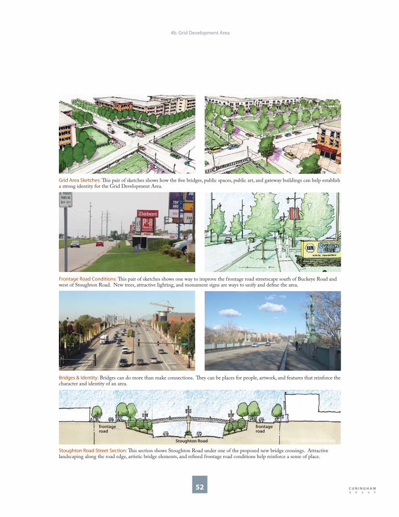
52
Grid Area Sketches: Th is pair of sketches shows how the fi ve bridges, public spaces, public art, and gateway buildings can help establish a strong identity for the Grid Development Area.
Frontage Road Conditions: Th is pair of sketches shows one way to improve the frontage road streetscape south of Buckeye Road and west of Stoughton Road. New trees, attractive lighting, and monument signs are ways to unify and defi ne the area.
Stoughton Road Street Section: Th is section shows Stoughton Road under one of the proposed new bridge crossings. Attractive landscaping along the road edge, artistic bridge elements, and refi ned frontage road conditions help reinforce a sense of place.
Stoughton Road
frontage road
frontage road
Bridges & Identity: Bridges can do more than make connections. Th ey can be places for people, artwork, and features that reinforce the character and identity of an area.
4b. Grid Development Area

53
Placemaking
Since buildings and intersections are the primary features that characterize this area, placemaking here should:
Prioritize building frontage and placement.
Highlight intersections and road frontage.
Focus on formed open space with strong edges defi ned by buildings.
Use signature buildings to create gateways.
Encourage landscaping features and public art at corners and within rights-of-way.
Increase interaction between businesses and adjacent neighborhoods.
Strategies for placemaking with the above criteria include the following:
•
•
•
•
•
•
Site important buildings in visible places and design and improve buildings with attractive, pedestrian-friendly frontage to reinforce the human scale. Prominent windows, doors, and architectural elements can achieve this.
Design walls, bridges, and planters along Stoughton Road to strengthen the area’s visibility. Materials, vegetation, and public art are some ways to highlight area strengths and reinforce its identity.
Incorporate open spaces to anchor buildings and create opportunities for gathering. Small scale, well-defi ned parks and plazas in multiple locations can achieve this.
Arrange buildings at intersections to mark them as gateways. A large, prominent building at each corner can reinforce this idea.
•
•
•
•
4b. Grid Development Area
Placemaking Precedents: Placemaking precedents and ideas appropriate for the Grid Development Area include a celebrated civic library building in Madison, WI (1), decorative vegetation and fencing along a depressed roadway in Saint Paul, MN (2), small scale public space defi ned by buildings in Cleveland, OH (3), and buildings situated to form a gateway in St. Louis Park, MN (4).
1 2
43

54
Community Connections
Th ere are several opportunities to establish better connections to, from, and within the Grid Development Area. Th ese connections can be physical, visual, and use-related:
Extend existing dead-end neighborhood streets to connect with the west side frontage road.
Build multi-modal bridges across Stoughton Road to connect the east and west sides.
Encourage neighborhood-oriented land uses along Stoughton Road to connect residential and commercial areas.
Coordinate long-term land uses on both sides of Stoughton Road to make economic connections between diff erent areas.
Consider this corridor for future phases of commuter rail. Th e City of Madison and Dane County have been studying concepts for commuter rail service, and although the rail corridor adjacent to the Grid Development Area is not under consideration for early phases, it could be for future phases. A rail stop on Buckeye Road could be a direct link to employment, commercial, and residential uses and could promote redevelopment opportunities.
•
•
•
•
•
New Connections: A new grid street network (red) allows for better access and connectivity between residential and commercial areas, and establishes an environment that meets the needs of motorists, bicyclists, and pedestrians alike.
Existing Conditions: Access between Stoughton Road, adjacent commercial areas, and surrounding neighborhoods is limited, and the areas are not connected to each other.
Commuter Rail Potential: Access and connectivity could be improved by a commuter rail stop at Buckeye Road, located directly adjacent to the Grid Development Area.
4b. Grid Development Area
Buckeye Road
Pfl aum Road
Potential Commuter
Rail Corridor
North
Buckeye Road
Pfl aum Road
Sto
ug
hto
n R
oa
d
Hob Street
Linda Vista Road
Helgesen Drive
Allis Ave
Ca
md
en
Ro
ad
North

55
Texas U-turn Pair vs. Bridges: Th e Plan proposes exchanging the Texas U-turn bridge pair for two multi-modal bridges.
WisDOT Alternative B: Stoughton Road is depressed between Buckeye Road and Pfl aum Road.
SRRP Plan RecommendationsTh is Plan recommends adjusting Alternative B to accomplish more eff ective community connections using the same number of bridges. Instead of three multi-modal bridges and two Texas U-turn bridges, this Plan recommends considering fi ve multi-modal bridges for pedestrians, cars, and bicycles. Th is Plan also recommends two two-way frontage roads instead of two one-way frontage roads to create better access to current businesses. Th e geometrics of this recommendation will need further study by WisDOT to determine the feasibility of two-way frontage roads, turning movements, stop-lights, stacking and access between bridges.
Th is Plan recommends a high level of design for the fi ve bridge structures, but is not recommending additional structures. It may be worthwhile for WisDOT to study diff erent combinations of pedestrian and multi-modal bridges between Buckeye and Pfl aum Roads to eff ectively connect the retail district across the corridor. Further analysis by WisDOT will be required to determine if the extra costs could become part of the reconstruction eff ort, or if other funding sources could be considered. Further study of geometrics and costs may make this recommendation prohibitive to both WisDOT and the City.
4b. Grid Development Area
Stoughton Road & WisDOT
Th is Plan recommends WisDOT’s Alternative B for the Grid Development Area, which maintains a tighter, more uniform right-of-way and thus provides a framework for improved connections across it, more effi cient development along its frontage roads, and better protection for established properties on adjacent blocks.
WisDOT Alternative BDepress Stoughton Road, grade-separate Buckeye and Pfl aum Roads, and make the pair of streets act as a “one split interchange.”
Build “Texas U-turn” bridges and one-way frontage roads to create a circuit around the area.
Create fi ve crossing structures: two overpasses (Buckeye and Pfl aum Roads), one multi-modal bridge (Helgesen Drive), and two Texas U-turn bridges (between Buckeye and Pfl aum Roads).
•
•
•
Buckeye Road
Pfl aum Road
Sto
ug
hto
n R
oa
d
Allis Avenue
Hob Street
Linda Vista Road
Helgesen Drive
Ca
md
en
Ro
ad
Farm &
Fleet
Dean
Clinic
BouMatic
Texas U-turn
Bridge
multi-modal
bridge
North
Texas U-turn
Bridge
Buckeye Road
Pfl aum Road
Helgesen Drive
Allis Avenue
Texas U-turn
Bridge
Texas U-turn
Bridge
multi-modal
bridge
Linda Vista Road
North

56
service for motorists may result in low levels of service for transit riders, bicyclists, pedestrians, and businesses along a street and intersection. It is important to create streets with high levels of service for all users, not just motorists. While delay is the primary consideration for motorists, levels of service should be measured diff erently for transit riders, pedestrians, and bicyclists. Transit LOS can be measured by frequency of buses and trains, and quality of waiting facilities. Pedestrian LOS can be measured by continuity of sidewalks, protection from weather, confl icts with other vehicles, air quality, and building frontage quality. Bicyclist LOS can be measured by evaluating the quality of bike lanes, intersection confl icts, and speed of adjacent vehicular traffi c.
Traffi c forecasts should be viewed as warnings not mandates. Traffi c forecasts are the result of assumed future land development and travel patterns. If projections and forecasts require extraordinarily costly infrastructure investments or if the projections will do irreparable damage to existing communities, then they should be interpreted as helpful and timely warnings, not mandates.
Th is Plan recognizes that two-way frontage roads, when modeled, may result in greater delay and a lower Level of Service (LOS) at the intersections than one-way frontage roads. Generally, one-way roads and one-way intersections process higher volumes of traffi c and therefore can reduce delay. Th is Plan, however, takes a strong position on the role of streets and transportation as they relate to encouraging high-quality urban redevelopment.
Urban intersections should not necessarily strive for Level of Service A, B, or C. LOS measurements are measurements of delay for motorists. Such measurements are biased toward automobile traffi c passing through an area and not necessarily traffi c that is destined to an area. To the degree that streets and intersections accommodate through-traffi c at the expense of bicyclists, transit riders, and pedestrians, they encourage and enable longer distance travel. Th is Plan suggests urban streets should be designed to balance multiple users, prioritizing those who contribute to a sustainable growth pattern over those who do not.
LOS measurements should take into account all users of the street and intersection. High levels of
4b. Grid Development Area
Level of Service A/B
Level of Service C/D
Level of Service E/F
Transit RidersPedestriansBicyclistsMotorists
Level of Service: Level of service for streets and intersections should apply to multiple users.

57
Strategic Phasing
Th e implementation process can begin immediately and should occur incrementally. Although the WisDOT project will not come online for many years, improvements can occur independent of, and in preparation for, possibly depressing Stoughton Road and building bridges across it. Th ese investments can occur as property ownership changes or owners wish to expand their businesses, or invest in their property. Potential redevelopment will help improve the appearance of the area and give it a more uniform identity. New connections will necessitate additional storm sewer capacity and more effi cient drainage systems to alleviate current, and prevent future, fl ooding problems.
Phase 1Since the right-of-way limits are essentially already determined by WisDOT, changes outside of the construction limits can begin immediately. Changes to the Grid Development Area can come from both the public and private sectors. General recommendations for early Phase 1 changes include:
Public Investments
Gateway landscaping and additional street trees.
Build new and improve existing sidewalks.
Add new street lights.
Private Investments
Improve building exterior conditions.
Update building facades and improve landscaping.
Install attractive signs.
Improve lighting design.
•
•
•
•
•
•
•
Phase 1 Opportunities: Neighbors like the facade improvements at Pelayo’s (top) and the attractive landscaping at BouMatic (bottom). Th ese examples show what can be done elsewhere in the Grid Development Area for immediate improvements.
Phase 1: Immediate opportunities for change include improving the streetscape with trees, lights, and sidewalks. Phase 1 also includes updating building facades, signs, lights, exteriors, and landscapes.
Buckeye Road
Pfl aum Road
Allis Avenue
Hob Street
Linda Vista Road
Helgesen Drive
Ca
md
en
Ro
ad
Sto
ug
hto
n R
oa
d
Farm &
Fleet
Dean
Clinic
BouMatic
Town of
Blooming
Grove
4b. Grid Development Area
North

58
Phase 2Phase 2 opportunities should include those from Phase 1, as well as:
Public Investments
Prepare to connect some neighborhood streets to the west frontage road and prepare for future rights-of-way.
Bring back the neighborhood park and play space as an additional connection between commercial and residential areas.
Commission and install public art in the neighborhood park.
Private Investments
Add on to existing buildings.
Build buildings at gateway intersections.
•
•
•
•
•
Phase 3Phase 3 opportunities should include those from Phases 1 and 2, as well as:
Public Investments
Connect other streets to west frontage road.
Construct bridges across Stoughton Road.
Expand sidewalks to make promenades and plazas.
Private Investments
Develop neighborhood commercial buildings along west frontage road.
Create opportunities for public art installations.
•
•
•
•
•
Phase 4Phase 4 opportunities should include those from Phases 1, 2, and 3, as well as:
Public Investments
Add and connect streets on the east side of Stoughton Road.
Add street trees, sidewalks, and lighting to new streets.
Install public artwork on bridges.
Private Investments
Develop neighborhood commercial area on east side of Stoughton Road.
•
•
•
•
Phase 2 Phase 3 Phase 4
Subsequent phasing of development opportunities depends on whether existing property owners wish to redevelop or add on to existing businesses. Th ese phasing diagrams are only an example of potential phases, as diff erent development opportunities can be interchangeable.
4b. Grid Development Area
Sto
ug
hto
n R
oa
d
Buckeye Road
Pfl aum Road
Allis Avenue
Hob Street
Linda Vista Road
Helgesen Drive
Ca
md
en
Ro
ad
North
Buckeye Road
Pfl aum Road
Allis Avenue
Hob Street
Linda Vista Road
Helgesen Drive
Ca
md
en
Ro
ad
North
Sto
ug
hto
n R
oa
d
Buckeye Road
Pfl aum Road
Allis Avenue
Hob Street
Linda Vista Road
Helgesen Drive
Ca
md
en
Ro
ad
North
Sto
ug
hto
n R
oa
d

59
Land Use
Land use designations for the Grid Development Area are a combination of General Commercial, Community Mixed-Use (CMU), Employment, and Business Mixed-Use areas. Th is combination of uses is designed to create a vibrant commercial district that supports residential uses to the west and industrial and manufacturing uses to the east.
Th e CMU areas at Buckeye and Pfl aum Roads will help make a transition between neighborhood and commercial uses in the area. When it is time for CMU areas at the Stoughton Road intersections of Buckeye and Pfl aum Roads to redevelop, they should do so with anchor-type uses that have a regional or city-wide function. Th ey should be multi-story mixed-use offi ce buildings that create gateways to the neighborhoods. Active uses such as retail, service, or community activities are
recommended on the ground fl oor with offi ces or apartments on upper fl oors.
Th e Business Mixed-Use district at Pfl aum Road mirrors the requirements of the CMU designation, but without residential uses. Th e form of this redevelopment is relatively dense, high-quality offi ce/retail/service that serves as a transition and support to the industrial areas to the east. Both the CMU and Business Mixed-Use areas will encourage more dense development to support multi-modal transit in the district.
Th e Plan recommends that Stoughton Road gradually and incrementally transition from low-density auto-oriented retail and commercial uses that serve a specialized regional niche to uses that serve a general East Side market. Additional car dealerships are highly discouraged; automotive services and auto-oriented businesses should be discouraged and included only as a part of a larger
Comprehensive Plan Proposed Land Use Map Illustrative Concept Plan
4b. Grid Development Area
Industrial
Mixed-Use Business
District: Employment &
Commercial
Employment
Low Density
Residential
Sto
ug
hto
n R
oa
d
Helgesen Drive
Allis Avenue
Buckeye Road
Pfl aum Road
Ge
ne
ral
Co
mm
erc
ial
Hob Street
POS
Ge
ne
ral
Co
mm
erc
ial
NMU
NMU
North
Linda Vista Road
Community
Mixed-Use
Community
Mixed-Use
Community
Mixed-Use
Dean
Clinic
BouMatic
Helgesen Drive
Allis Avenue
Buckeye Road
Pfl aum Road
Hob Street
Linda Vista Road
North

60
high-quality retail and mixed-use development.
Uses will continue to be primarily commercial and many buildings will likely remain one-story in height; however, properties with buildings located at the rear of the site should, over time, redevelop to a more pedestrian-oriented format by locating buildings toward the frontage road. Existing and new buildings should face the frontage road with front doors and entries connected to new sidewalks. Surface parking is encouraged behind and to the side of buildings, but limited convenience parking (maximum 60 feet wide) is permitted in front of the buildings on sites not located on corners. Th e Plan recommends that several local streets on the west side of Stoughton Road connect from
Camden Road to the west frontage road. Th ese potential connections to Camden Road are a part of a decades-long vision for the future and would not occur for many years. In the case of such connections, redevelopment along them should contain housing or small neighborhood-scaled uses. Retail uses are acceptable on the frontage road.
Where Hob Street potentially connects the west frontage road and Camden Road, the Plan recommends creating a neighborhood park to replace the park that was lost during construction of the Lussier Stadium at LaFollette High School. If the street connection is made, and the park is built, the adjacent land use designation should also be changed to Neighborhood Mixed-Use (NMU), and include two-three story mixed-use buildings with retail on the ground fl oor, and residential or offi ce above. An NMU land use designation for this small area will help defi ne the park and create a neighborhood center node. Th is location is also an appropriate place for a civic building, such as a community center. Parking for these buildings should be behind or beneath the buildings.
Th e Plan recommends investments on Camden Road to improve the condition of the housing and the neighborhood. Public and private infrastructure investment should encourage Hob Street redevelopment. Th e Plan does not recommend changing land uses on Camden Road. New housing should be compatible in scale and density with existing housing.
Block Guidelines LegendLocate the building within ten feet of the front property line where possible. Minimize parking exposure to the sidewalk by limiting parking to 60 feet in width.
Mark the corner of the block with an architectural element.
Create a neighborhood park or green space.
Locate the building within ten feet of the front property line. Locate parking behind or beneath the building.
Reinforce the residential street with residential uses and front yards.
Create new street right-of-way and block perimeter.
4b. Grid Development Area
Allis Ave
Linda Vista Road
Helgesen Drive
Buckeye Road
Ca
md
en
Ro
ad
Pfl aum Road
Hob Street
BouMatic
Dean
Clinic
Sto
ug
hto
n R
oa
d
North
Block Guidelines

61
Building TypesGateway Building
Minimum of three stories in height at the corner. Minimum of two stories on remainder of lot.
Massing, signs, bay structure, and roof forms to be visible from Stoughton Road and proportional to the larger scale of the corridor.
Entrances, materials, and massing to be proportional to pedestrian scale.
Buildings to be situated in context with other buildings to create gateway eff ect along Stoughton Road and to the neighborhoods.
Doors and windows at street level to be proportional to the human scale and should create interest to passersby.
Parking to be located behind or to the side of buildings in well landscaped parking lots or parking structures.
•
•
•
•
•
•
1
Neighborhood Mixed-Use Building
Two to four stories in height.
Active uses such as retail or community uses to occupy the ground fl oor.
Upper fl oors can contain residential units or small offi ces.
Buildings can help accommodate the transition from Stoughton Road to the neighborhood.
•
•
•
•3
Mid-Block Commercial BuildingOne to two stories in height.
Larger fl oor plates, or sizes, are acceptable for larger users.
Loading and parking to be located behind buildings, a limited amount of convenience parking is permitted in front.
Entries to face Stoughton Road and connect to new sidewalks and parking areas.
•
•
•
•2
Residential BuildingTwo to three stories in height.
Townhouses, rowhouses and small multi-family buildings to create a neighborhood transition between commercial and residential areas
Porches, stoops, and front yards to animate the street and encourage a vibrant neighborly feeling and image.
•
•
•
4
4b. Grid Development Area
1BouMatic
Dean
Clinic
Sto
ug
hto
n R
oa
d
1
3
Helgesen Drive
Buckeye Road
Pfl aum Road
3
Ca
md
en
Ro
ad
2
3
4
1
3
North
Allis Avenue

62
1
Landscape TypesStreetscape
New and reconstructed frontage roads to be enhanced with sidewalks, street trees, regularly spaced curb-cuts, and coordinated signs and lighting.
•
Neighborhood ParkPark to be designed for public gathering, civic activities, and neighborhood events.
Park to be a neighborhood amenity designed to maximize safety and security for residents.
Park to be designed in conjunction with redevelopment.
Park to create a transition between it and the commercial areas.
•
•
•
•
2
Surface Parking LotParking lots to be no more than 60 feet wide when located in front of buildings.
Parking lots to be heavily landscaped and with edges well defi ned by hedges or short fences.
Parking lots to incorporate clear pedestrian markings to connect to building entries and sidewalks.
Parking lots to be designed to minimize impacts on neighbors when located behind buildings.
•
•
•
•
5
Bridges Bridges to reinforce area character and identity to passing motorists.
Bridges to incorporate coordinated lighting, landscaping, and signs.
Bridges can be coordinated with additional street improvements.
•
•
•
3
Art Art elements can be installed in public areas such as parks and streetscapes.
Art elements to be present in visible locations such as gateway intersections.
Art elements to be incorporated into private development projects.
•
•
•
4b. Grid Development Area
3
5
1
5
32
3
4
4
4
4
Sto
ug
hto
n R
oa
d
Helgesen Drive
Allis Avenue
Buckeye Road
Pfl aum Road
Linda Vista Road
Ca
md
en
Ro
ad
BouMatic
Dean
Clinic
North
4

4c. Gateway Development Area
Identity Placemaking Community Connections Stoughton Road & WisDOT Strategic Phasing Land Use Block Guidelines Building Types Landscape Types

64
Identity
Th e Gateway Development Area is located on the northeast corner of the U.S. Highway 12-18 and Stoughton Road intersection. As redevelopment occurs, the area is poised to become a major gateway to both Madison and the East Side. Here, Stoughton Road is accessed through at-grade signalized intersections at East Broadway and a grade separated interchange at the U.S. Highway 12-18 Beltline. Frontage conditions include vegetation, roads, and buildings, as well as a successful park-n-ride lot serving both Metro Transit buses and regional buses that service cities like Chicago.
Th is Development Area has a mixture of large natural features, industry and employment centers, as well as a hodgepodge of smaller industrial, residential, and commercial uses. Th e BioAg Employment District is part of a growing employment sector in the area; however, the entrance to the gateway area at East Broadway and Femrite Drive presents a less than cohesive image.
Its visible location inspires the Gateway name, and the Plan recommends infrastructure and economic development to help make the district live up to its prominent location. Area strengths include visibility, natural features, and concentration of industrial and research-oriented employment
Existing Conditions: Buildings in the Fen Oak area incorporate creative landscape features (1). Trees give defi nition to some internal access roads (2), but the area entrance is a hodgepodge of uses and lacks a cohesive gateway (3).
2
1
Gateway Development Area: Th e Gateway Development Area is located in the south end of the study area, and includes properties northeast of Stoughton Road and Highway 12-18.
3
4c. Gateway Development Area
2
1
Femrite Drive
E Broadway
US Highway 12-18
Sto
ug
hto
n R
oa
d
Pfl aum Road
3
North
opportunities. Weaknesses are limited access to Stoughton Road, a mixture of zoning, awkwardly shaped land parcels, incongruent uses, limited connectivity within the area, and minimal relationship to natural features.

65
Illustrative Concept Plan: Build-out of the Gateway Development Area will leverage natural features and the corner location. Under-utilized properties will be redeveloped as a mixed-use center or campus.
4c. Gateway Development Area
Gateway Concept: Th e overall concept for the Gateway Development Area is to make new infrastructure connections to improve access to the area, to take advantage of the site’s position as a gateway, and to reinforce it as an employment center.
E Broadway
Femrite Drive
Sto
ug
hto
n R
oa
d
US Highway 12-18
North
Flyover Option: One of WisDOT’s concepts introduces a fl yover interchange in the area. Th e presence of a fl yover will aff ect redevelopment in the southwest corner of the Gateway Development Area.
US Highway 12-18
Sto
ug
hto
n R
oa
dE Broadway
North
Femrite Drive
E Broadway
US Highway 12-18
Sto
ug
hto
n R
oa
d
Pro
gre
ss R
oa
d
Ag
ricu
ltu
re D
riv
e
Tradewinds Parkway
North
fi re
station
park-n-
ride
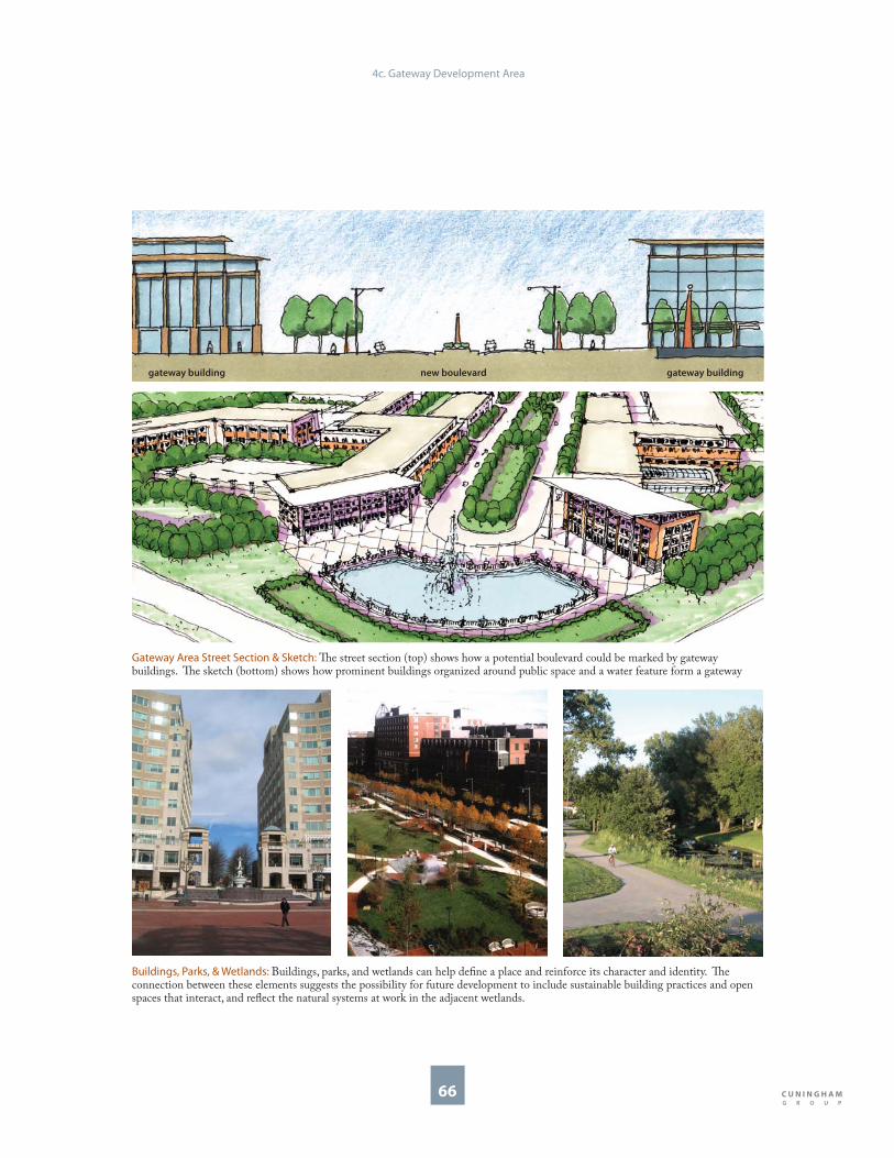
66
Gateway Area Street Section & Sketch: Th e street section (top) shows how a potential boulevard could be marked by gateway buildings. Th e sketch (bottom) shows how prominent buildings organized around public space and a water feature form a gateway
new boulevardgateway building gateway building
Buildings, Parks, & Wetlands: Buildings, parks, and wetlands can help defi ne a place and reinforce its character and identity. Th e connection between these elements suggests the possibility for future development to include sustainable building practices and open spaces that interact, and refl ect the natural systems at work in the adjacent wetlands.
4c. Gateway Development Area

67
Placemaking
Since large wetlands, a density of employment and a strong visual presence characterize this area, placemaking here should:
Prioritize wetlands and open spaces. Find opportunities for sustainable growth and building development.
Highlight visible features and high quality design.
Focus on creating central public spaces.
Use signature buildings to create gateways.
Strategies for placemaking with the above criteria include the following:
Maximize access to responsible development around wetlands and open spaces to reinforce
•
•
•
•
•
their presence.
Encourage ways to improve access and sustainable development by constructing green buildings and sustainable pilot projects, adding public streets adjacent to wetlands, and extending trail systems from wetlands to new development.
Use architecture and building form to capitalize on the area’s visibility from the U.S. Highway 12-18. Strong corners, well-marked entries, rich colors and attractive details are parts of buildings best able to display a strong, cohesive presence.
Create open spaces and plazas to defi ne centers and encourage activity. Sidewalk cafes, central parks and small plazas are examples.
Arrange buildings at intersections to mark them as gateways. Large, prominent buildings visible from U.S. Highway 12-18 can reinforce this idea.
•
•
•
•
Placemaking Precedents: Placemaking precedents and ideas appropriate for the Gateway Development Area include a lively outdoor space for people in Los Angeles, CA (1), a richly designed industrial building in Madison, WI (2), a central public space in New York City (3), and a uniform campus building with strong gateway and entrance element in Boston, MA (4).
1 2
43
4c. Gateway Development Area

68
New Connections: A new grid street network (red) allows for better connectivity between previously disconnected areas and expands opportunities for physical and visual relationships.
Park-n-Ride: Access and connectivity are enhanced by the existing park-n-ride lot. Th is lot, while currently not an attractive feature, does provide a great service to commuters, Metro Transit bus riders, and people who use regional bus service to surrounding communities and large cities like Milwaukee, Minneapolis, and Chicago. Th is park-n-ride lot could become an attractive feature and become an urban amenity as part of a redevelopment project.
Community Connections
Th ere are several opportunities to establish better connections to, from, and within the Gateway Development Area. Th ese connections can be physical, visual, and use-related:
Create new streets to connect existing dead-ends and limited access streets.
Create new streets along wetland edges to connect people with existing natural systems.
Establish a coordinated land use approach to connect existing employment area with related services.
Encourage new development for employment related services currently missing in the corridor. Th ese services include, but are not limited to:
Offi ce services: copying, duplication, etc.
Dentists and other professional services.
Banking and other fi nancial services.
Restaurants, bakeries, and grocery stores.
Dry cleaning, hotel facilities, shopping, and entertainment, and other service retail.
Establish connections with the larger region by creating a destination area.
Promote continued park-n-ride service with expansion possibilities as part of a redevelopment project.
•
•
•
•
•
•
•
•
•
•
•
4c. Gateway Development
Femrite Drive
Sto
ug
hto
n R
oa
d
E Broadway
US Highway 12-18
North
Existing Conditions: Access and connectivity are limited in the Gateway Development Area. Many properties, like the one shown above, are oriented away from wetlands and do not off er access to them.
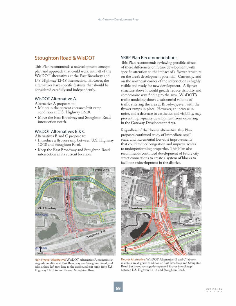
69
Stoughton Road & WisDOT
Th is Plan recommends a redevelopment concept plan and approach that could work with all of the WisDOT alternatives at the East Broadway and U.S. Highway 12-18 intersection. However, the alternatives have specifi c features that should be considered carefully and independently.
WisDOT Alternative A Alternative A proposes to:
Maintain the current entrance/exit ramp condition at U.S. Highway 12-18.
Move the East Broadway and Stoughton Road intersection north.
WisDOT Alternatives B & C Alternatives B and C propose to:
Introduce a fl yover ramp between U.S. Highway 12-18 and Stoughton Road.
Keep the East Broadway and Stoughton Road intersection in its current location.
•
•
•
•
Non-Flyover Alternative: WisDOT Alternative A maintains an at-grade condition at East Broadway and Stoughton Road, and adds a third left turn lane to the eastbound exit ramp from U.S. Highway 12-18 to northbound Stoughton Road.
Flyover Alternative: WisDOT Alternatives B and C (above) maintain an at-grade condition at East Broadway and Stoughton Road, but introduce a grade-separated fl yover interchange between U.S. Highway 12-18 and Stoughton Road.
4c. Gateway Development Area
Femrite Drive
Old E Broadway
Sto
ug
hto
n R
oa
d
new E Broadway alignment
North
US Highway 12-18
SRRP Plan RecommendationsTh is Plan recommends reviewing possible eff ects of these diff erences on future development, with specifi c attention to the impact of a fl yover structure on the area’s development potential. Currently, land on the northeast corner of the intersection is highly visible and ready for new development. A fl yover structure above it would greatly reduce visibility and compromise way-fi nding to the area. WisDOT’s traffi c modeling shows a substantial volume of traffi c entering the area at Broadway, even with the fl yover ramps in place. However, an increase in noise, and a decrease in aesthetics and visibility, may prevent high-quality development from occurring in the Gateway Development Area.
Regardless of the chosen alternative, this Plan proposes continued study of immediate, small-scale, and incremental low-cost improvements that could reduce congestion and improve access to underperforming properties. Th is Plan also recommends continued development of future city street connections to create a system of blocks to facilitate redevelopment in the district.
fl yover r
amp
E Broadway
US Highway 12-18
Sto
ug
hto
n R
oa
d
fl yover r
amp
fl yover ramp
fl yover ram
p
Femrite Drive
North

70
At-Grade Options: Two non-fl yover options suggest adding street network and limited access points. Th e “ring road” option (left) suggests keeping the East Broadway intersection as “right-in, right-out” access only and adding an all-way intersection in Alternative A’s proposed East Broadway realignment. Th e “fi gure 8” option (right) suggests keeping the same access points as the “ring road” option, but adds another access north of the East Broadway realignment. Each of these three access points would be “right-in, right-out” only.
At-Grade Overpass Options: Additional non-fl yover options suggest using Alternative A’s East Broadway realignment and bringing it over Stoughton Road. Th e “single crossing” option (left) does this and eliminates the current East Broadway road. Th e “double crossing” option (right) does the same, but adds an additional overpass in the current East Broadway alignment that does not intersect with Stoughton Road. Further study will have to determine how these proposed crossings interact with the depression of the corridor further north.
Interim Congestion Relief SuggestionsWisDOT’s primary goal for the traffi c issues in the Gateway Development Area is to relieve traffi c backups on the eastbound exit ramp from U.S. Highway 12-18 to northbound Stoughton Road, and increase levels of service throughout the corridor. Th ese backups are both a safety hazard for motorists, and a nuisance during peak travel times. As development and redevelopment on the East Side of Madison and in the corridor continues, this area will experience additional traffi c pressure.
Th e fl yover ramp, as designed by WisDOT, will bypass the existing intersection, thereby allowing free-fl ow eastbound to northbound (and, conversely, southbound to westbound) movements. Th is fl yover solution does not address access challenges or land use issues, and does not improve visual access to the Gateway Redevelopment Area. Th us, this Plan
suggests studying additional non-fl yover options that address a broader range of issues.
Th e proposed concepts in this Plan, highlighted below, are not fully designed. Design issues concerning the height diff erential between these design concepts and the start of the depressed roadway at Pfl aum Road farther north will need to be addressed.
Th ese concepts, as well as others, would need further analysis by WisDOT during continued study of the corridor. Th is may also be an opportunity to explore other design ideas that would help support high-quality redevelopment and economic growth in the Gateway Development Area without sacrifi cing the need to reduce driving hazards on the West Beltline, and levels of service in the Stoughton Road corridor.
Ring-Road Concept Figure-Eight Concept
Single-Crossing Concept Double-Crossing Concept
4c. Gateway Development Area
Sto
ug
hto
n R
oa
d
Femrite Drive
US Highway 12-18right-in
right-out
all-way
North
Sto
ug
hto
n R
oa
d
Femrite Drive
right-in
right-out
right-in
right-out
right-in
right-out
NorthUS Highway 12-18
Sto
ug
hto
n R
oa
d
Femrite Drive
overpass
North
US Highway 12-18
Sto
ug
hto
n R
oa
d
Femrite Drive
overpass
North
US Highway 12-18

71
Urban Design Eff ects of the Flyover & Non-Flyover OptionsHigh volumes of eastbound U.S. Highway 12-18 to northbound Stoughton Road traffi c (and conversely southbound Stoughton Road to westbound U.S. Highway 12-18 traffi c), combined with short exit ramps and tight intersection spacing, create backups on U.S. Highway 12-18.
Likewise, confl icts between interchanging traffi c and through-traffi c in the short distance between the East Broadway intersection and U.S. Highway 12-18 ramps create congestion. Flyover ramps will reduce U.S. Highway 12-18 backups by allowing vehicles to “fl y over” the East Broadway intersection and avoid it altogether. Th is eliminates confl icts in the space between East Broadway and the U.S. Highway 12-18 ramps.
Land Use
Th e fl yover solution allows regional traffi c passing through the East Side to do so with greater ease, but it does not increase access or connectivity to local businesses or residences. Improved access is achieved through improved street networks, transit options, multi-modal solutions, and a mix of land
uses. Absent additional access improvements at intersections and additional street network, the fl yover will not bring about a mix of land uses.
It is true that non-fl yover solutions will not relieve the backups on the U.S. Highway 12-18 as eff ectively as the fl yover. Th ey will relieve some congestion, but travel time through the intersections will most likely be greater than in the fl yover option. While the fl yover option creates a free-fl ow interchange that avoids the Broadway intersection, it also requires a high level of wayfi nding and driver knowledge of the area. Th is is especially true given the unusual split intersection that will be used at Pfl aum and Buckeye Roads to the north. Th e combination of these two designs could cause a problem to land uses and commercial ventures that partially rely on drive-by traffi c and visual access. Several development opportunities may be lost due to the diffi cult array of options facing drivers who may miss their turns in this system. Because of the added time required to negotiate and learn the system of the fl yover, development may happen more slowly, and may require a single large developer rather than smaller incremental improvements.
Non-Flyover Design Implications
Involves delay, and back-ups
Facilitates access to Gateway Area
Requires little additional wayfi nding
Supports a mix of land uses
Growth can happen by many developers/users
Flyover Design Implications
Involves no delay
Facilitates movement and capacity
Requires new wayfi nding and driver knowledge
Supports regional destinations & limited land-uses
Economic growth may require single large user
4c. Gateway Development Area
Femrite Drive
US Highway 12-18E Broadway
Sto
ug
hto
n
Ro
ad
North
Femrite Drive
US Highway 12-18E Broadway
Sto
ug
hto
n
Ro
ad
North

72
Wayfi nding: Th e fl yover ramps will require motorists to use signs, not intuition.
Wayfi nding
Both the non-fl yover and fl yover options will require diff erent ways of navigating the East Side. Currently, wayfi nding from U.S. Highway 12-18 to destinations on Stoughton Road is intuitive: motorists exiting eastbound U.S. Highway 12-18 to Stoughton Road turn left to access destinations to the north and right to access destinations to the south.
Th e fl yover scenario relies more on signs than on intuition. Th e presence of the fl yovers requires eastbound U.S. Highway 12-18 to northbound Stoughton Road motorists to make more educated decision: to bypass the East Broadway intersection and access destinations north of it (via the fl yover) or to exit U.S. Highway 12-18 at Stoughton Road
Typical Highway Wayfi nding Signs
Business District Wayfi nding Sign Example
4c Gateway Development Area
exit for South Stoughton Road and East Broadway and Femrite Drive
exit for North Stoughton Road, excluding East Broadway and Femrite Drive
E Broadway
fl yover fl yover
Sto
ug
hto
n R
oa
d
North
fl yover
for some areas north (including East Broadway and the Gateway Development Area) and all areas south.
Th e non-fl yover wayfi nding will be more intuitive. Better visual access into the Gateway Area development will provide an opportunity for branding and marketing the area as a district. Th ese signs will not have to be visually overpowering, unlike signs that may be needed for the fl yover scenario. District wayfi nding techniques often include lighting, signs, and streetscape elements such as benches and banners. Th is kind of enhanced streetscape can be carried through to redevelopment of the park-n-ride lot and other public amenities that encourage a mix of uses in this development area.

73
Visibility
Visibility to the Gateway Development Area will diff er signifi cantly in the two scenarios. In the non-fl yover option, visibility will not change. Th e area will continue to have a strong visual presence at Stoughton Road and from U.S. Highway 12-18 in both directions.
In the fl yover option, the Gateway Development Area visibility will remain strong from westbound U.S. Highway 12-18. However, visibility will be compromised for eastbound to northbound motorists. Th e fl yover ramps will rise approximately 50 feet, but the combination of the banked roadway (super-elevation) and side safety barriers will obstruct views to the Gateway Development Area. Ground visibility from Stoughton Road also will be compromised by columns, shadowing, and structures.
Flyover Alternative Street Sections: A cross-section looking north on Stoughton Road toward East Broadway Avenue (top) and looking west on East Broadway Avenue toward Stoughton Road (bottom) shows the fl yover structure and accompanying visual elements.
Stoughton Roadfl yover fl yover
E Broadway
fl yover
4c. Gateway Development Area
exit for South Stoughton Road and East Broadway and Femrite Drive
East Broadway
A A
B
B
North

74
Orientation & Development Potential
Th e relationship between land use, urban design, wayfi nding, and visibility and the non-fl yover and fl yover options will help to determine the success of the Gateway Development Area’. A mix of land uses, which includes major commercial and service-oriented uses, relies on destination traffi c as well as spontaneous traffi c. Destination traffi c needs clear wayfi nding tools, while spontaneous traffi c responds to strong visibility. If one of these is missing, the strength of each weakens and changes. For example, in the fl yover option, signifi cant amounts of potential spontaneous commercial traffi c does not see the area, bypasses it, and does not use it. Th us, in the fl yover scenario, the viability of commercial mixed-use district is greatly reduced, and could occur only as part of a larger employment district development.
Since both the non-fl yover and fl yover alternatives are options for the area, it is important that development prepares for both. Th is Plan proposes two responses: one in a non-fl yover scenario and another in a fl yover scenario. Each allows the area to establish a strong orientation to the south, as this is the primary entrance to Madison from all points east. However, because the size, sound, and visual eff ects of the fl yover will reduce the amount of desirable, and therefore developable, land, the
orientation of development will focus inward and away from Stoughton Road and the fl yover.
Th e non-fl yover option does not have the same size, sound, and visual impacts, and therefore does not need to turn away from Stoughton Road. In fact, it should be oriented toward Stoughton Road. Th is off ers stronger, more defi ned visibility to the high volumes of vehicles approaching Stoughton Road from the west, and also sets up an opportunity for a possible complementary gateway development on the Monona side of Stoughton Road.
Most Gateway Development Area uses should be destination and employment uses. Development such as medical, technology, and research offi ces, as well as other uses that rely on regional access to a large workforce, the airport, and to the Interstate, are likely to fuel much of the redevelopment. Like many highway interchanges, the southwest portion of the Gateway Development Area would likely attract commercial, retail, and hotel investments in the non-fl yover option. It is visible to passersby, easy to get to, and appropriately sized for such a development. Th e fl yover option will likely create just enough wayfi nding and visibility challenges that commercial, retail, and hotel investments would seek a better location elsewhere.
4c. Gateway Development Area
Non-FlyoverPublic Space and Orientation: Public space is oriented outward in the non-fl yover option and inward in the fl yover option. Th is is because the space is a gateway element in the non-fl yover option and an internal element in the fl yover option.
Flyover
Developable Land: Th ere is a larger area of developable land in the non-fl yover option than there is in the fl yover option. Th is is because land near and beneath the fl yover structure becomes less attractive to development.
Femrite Drive
US Highway 12-18E Broadway
Sto
ug
hto
n
Ro
ad
North
Femrite Drive
E Broadway
North
US Highway 12-18
Femrite Drive
E Broadway
North
US Highway 12-18
Femrite Drive
E Broadway
North
US Highway 12-18
75
Strategic Phasing
Given the likelihood of rebuilding the U.S. Highway 12-18 and Stoughton Road intersection is approximately 15 to 20 years away, this Plan recommends focusing redevelopment eff orts in the northeast portion of the Gateway Development Area, away from the intersection. Th is allows the area to evolve in anticipation of WisDOT’s plans, but independent of the eff ects of a potential fl yover. Once the non-fl yover versus fl yover decision is made, development will respond accordingly.
Th is Plan works with both the non-fl yover and fl yover options. Phases 1 and 2 develop in the same way regardless of WisDOT’s plans. Th e diff erence is in Phase 3, when development options refl ect non-fl yover or fl yover conditions.
SRRP Plan RecommendationsTh e main diff erence illustrated by this Plan is the degree of commercial and mixed uses in the southwest corner of the Gateway Development Area and the degree to which the development is oriented west. Since the fl yover renders the southwest corner less viable for mixed-use development and more viable for single-use or campus-like development, it will be less of a gateway if the fl yover is built. With either scenario, the area can be a destination employment center.
Despite its proximity to the Interstate and to several successful businesses, this area is underperforming economically. Access to the area is poor, and there are many oddly shaped, mismatched property sizes with varied owners and zoning classifi cations. While some new infrastructure, such as the Voges Road bridge, was created as part of the BioAg Gateway, the remaining infrastructure is substandard. Street network improvements will improve access to and connectivity within the area. Th ese improvements also will create more effi cient and appropriately sized development parcels. Th e infrastructure improvements are strategically phased to work with the larger Stoughton Road improvements timetable, specifi cally with the eventual reconstruction of the U.S. Highway 12-18 and Stoughton Road intersection.
Phase 1
Connect East Broadway (on the west side of Stoughton Road) to Femrite Drive (on the east side of Stoughton Road). Th is connection will relocate the primary intersection with Stoughton Road approximately 800 feet north of its current location. Th e existing intersection will remain, but will become a right-in and right-out intersection. Th is connection will also improve access to development areas west of I-90 / I-39.
Connect Stoughton Road to Tradewinds Parkway and eventually to Agriculture Drive. Th is connection will improve access to the Gateway Development Area and BioAg Gateway by creating a “back door” via Agriculture Drive.
Extend the Stoughton Road frontage road south to Femrite Drive. Th is connection will improve access to the Gateway Development Area by creating additional street network independent of Stoughton Road.
Provide access to parcels and the wetlands with a new park drive. Th is will increase public visibility and access to these important natural features.
Phase 2
Create new streets between Femrite Drive and East Broadway. A new street grid will encourage investment in underutilized properties. Improving this area will create high-quality, highly-visible parcels. Th e properties will occupy highway frontage and will become the front door to Madison from the east.
Phase 3A (Non-Flyover)
Create new streets oriented to the Stoughton Road and U.S. .Highway 12-18 intersection. A signifi cant new park, oriented toward the intersection, can organize the development and create a second highly visible development addresses for the area.
Phase 3B (Flyover)
Insert a new street between Femrite Drive and Dutch Mill Road. Th is redevelopment area can be oriented around an internally focused green space.
•
•
•
•
•
•
•
4c. Gateway Development Area

76
Gateway Area Phasing Plans: Phase 1 includes new streets (red) and development opportunities (salmon) focused primarily in the northeast part of the area (1), Phase 2 makes additional connections and buildings extending toward the southwest and the U.S. Highway 12-18 and Stoughton Road intersection (2), Phase 3A shows build-out without fl yover (3A), and Phase 3B shows build-out with fl yover (3B).
Phase 1:Network improvements increase access to area. Development focused on northeast portion of area.
Phase 3A Non-Flyover:Development occupies the southwest corner and is a mixed-use destination, employment center, and gateway.
Phase 3B Flyover:Development occupies the southwest corner and is a single-use employment center and campus.
Phase 2:Additional local network to increase redevelopment opportunities. Development extends toward southwest.
4c. Gateway Development Area
1
Femrite Drive
E Bro
adway
Tradewinds Parkway
Sto
ug
hto
n R
oa
d
Ag
ricu
ltu
re D
riv
e
US Highway 12-18
North
3A
E Broadway
North
Femrite Drive
E Bro
adway
Tradewinds Parkway
Sto
ug
hto
n R
oa
d
Ag
ricu
ltu
re D
riv
e
US Highway 12-18
3BNorth
Femrite Drive
E Bro
adway
Tradewinds Parkway
Sto
ug
hto
n R
oa
d
Ag
ricu
ltu
re D
riv
e
E Broadway US Highway 12-18
2North
Femrite Drive
E Bro
adway
Tradewinds Parkway
Sto
ug
hto
n R
oa
d
Ag
ricu
ltu
re D
riv
e
US Highway 12-18

77
Land Use
Proposed Land Use Map (top) & Illustrative Conceptual Redevelopment Plan (bottom)
4c. Gateway Development Area
Femrite Drive
Ag
ricu
ltu
re D
r
US Highway 12-18
E Broadway
North
Sto
ug
hto
n R
oa
d
Industrial
Mixed-Use Business District:
Commercial and Employment
Industrial
Employment
Femrite Drive
Park & Open Space
Dutc
h Mill
Road
Ellestad Drive
Pro
gre
ss R
oa
d
E Broadway
Da
iry
Dri
ve
Industrial
Park & Open
Space
Tradewinds Parkway
E Broadway
Mixed-Use Business District:
Commercial and Employment
North
Sto
ug
hto
n R
oa
d
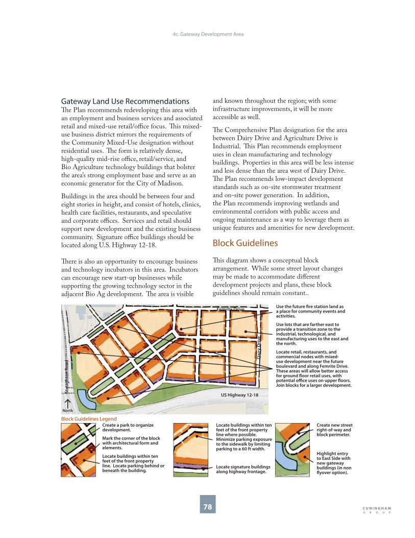
78
Locate retail, restaurants, and commercial nodes with mixed-use development near the future boulevard and along Femrite Drive. These areas will allow better access for ground fl oor retail uses, with potential offi ce uses on upper fl oors. Join blocks for a larger development.
Gateway Land Use Recommendations Th e Plan recommends redeveloping this area with an employment and business services and associated retail and mixed-use retail/offi ce focus. Th is mixed-use business district mirrors the requirements of the Community Mixed-Use designation without residential uses. Th e form is relatively dense, high-quality mid-rise offi ce, retail/service, and Bio Agriculture technology buildings that bolster the area’s strong employment base and serve as an economic generator for the City of Madison.
Buildings in the area should be between four and eight stories in height, and consist of hotels, clinics, health care facilities, restaurants, and speculative and corporate offi ces. Services and retail should support new development and the existing business community. Signature offi ce buildings should be located along U.S. Highway 12-18.
Th ere is also an opportunity to encourage business and technology incubators in this area. Incubators can encourage new start-up businesses while supporting the growing technology sector in the adjacent Bio Ag development. Th e area is visible
and known throughout the region; with some infrastructure improvements, it will be more accessible as well.
Th e Comprehensive Plan designation for the area between Dairy Drive and Agriculture Drive is Industrial. Th is Plan recommends employment uses in clean manufacturing and technology buildings. Properties in this area will be less intense and less dense than the area west of Dairy Drive. Th e Plan recommends low-impact development standards such as on-site stormwater treatment and on-site power generation. In addition, the Plan recommends improving wetlands and environmental corridors with public access and ongoing maintenance as a way to leverage them as unique features and amenities for new development.
Block Guidelines
Th is diagram shows a conceptual block arrangement. While some street layout changes may be made to accommodate diff erent development projects and plans, these block guidelines should remain constant..
Locate buildings within ten feet of the front property line where possible. Minimize parking exposure to the sidewalk by limiting parking to a 60 ft width.
Locate signature buildings along highway frontage.
Create new street right-of-way and block perimeter.
Highlight entry to East Side with new gateway buildings (in non fl yover option).
Create a park to organize development.
Mark the corner of the block with architectural form and elements.
Locate buildings within ten feet of the front property line. Locate parking behind or beneath the building.
Block Guidelines Legend
Use the future fi re station land as a place for community events and activities.
Use lots that are farther east to provide a transition zone to the industrial, technological, and manufacturing uses to the east and the north.
Femrite Drive
US Highway 12-18
Sto
ug
hto
n R
oa
d
Da
iry
Dri
ve
4c. Gateway Development Area
North

79
Building Types
1
1
Clean Industrial/Tech BuildingMinimum of two stories in height.
Entries and roof forms should be clearly expressed.
Loading and service should be located behind the building.
Building can be set back from the street to accommodate parking and generous landscaping.
Building should be designed in conjunction with others to create a cohesive campus arrangement.
Businesses are encouraged to provide space for showcasing processes and products to the public.
•
•
•
•
•
•
3
3
3
Mixed-Use BuildingMinimum of four stories in height.
Ground fl oor can contain active retail, services, or restaurant uses.
Building should be located within 10 feet of the front property line to activate the public realm.
Parking should be located behind the building in well landscaped surface lots or parking structures.
•
•
•
•
2
22
Civic Building Future fi re station should follow the example of Fire Station #11, a green built civic structure that is well designed and adds to the image of the area.
•
4c. Gateway Development Area
North
Gateway Offi ce BuildingMinimum of four stories in height.
Massing, entrance features, signs, bay structure, materials, and roof forms to be visible from Stoughton Road and U.S. Highway 12-18.
Materials should be high quality and durable, that read at both the automobile and the pedestrian scales.
Doors and windows at street level to be proportional to human scale and should create interest to passersby.
Buildings can address the park frontage with overlooks, balconies, roof terraces, and other outdoor amenities.
•
•
•
•
•
1
1
3
2 2
Femrite Drive
US Highway 12-18
E Broadway
Sto
ug
hto
n R
oa
d
Da
iry
Dri
ve
North
4
3

80
Landscape Types
WetlandsWetlands should be viewable from buildings and roads, accessible from trails, and connected physically and visually to manicured landscapes.
Natural materials such as wood, stone, and native vegetation can operate as functional and artistic elements.
Restored and maintained wetlands should be important amenities to new development.
Low impact trails and paths will encourage public access and recreation.
Existing and new wetlands should be part of on-site stormwater treatment.
•
•
•
•
•
1
1
Park & Campus GreenNew development should be oriented around a publicly accessible open space.
Parks and greens can be designed as centerpieces and signature amenities to development.
•
•
2
2
Water Feature and Public ArtFormal water feature can mark the gateway entry to the East Side and highlight Madison as a city of lakes.
Public amenities and urban features should be interactive and artistic.
•
•
StreetscapeNew streets are necessary to encourage high-quality new development.
All streets should be designed for bicycles, pedestrians, trucks, transit, and cars.
•
•
4
4c. Gateway Development Area
3
33
3
1
2
3
4 4
North
Femrite Drive
US Highway 12-18
E Broadway
Sto
ug
hto
n R
oa
d
Da
iry
Dri
ve

5. Implementation
Plan Adoption & Implementation City of Madison Planning Process Implementation Tools and Strategies Short-Term Implementation Medium-Term Implementation Long-Term Implementation Continued Implementation
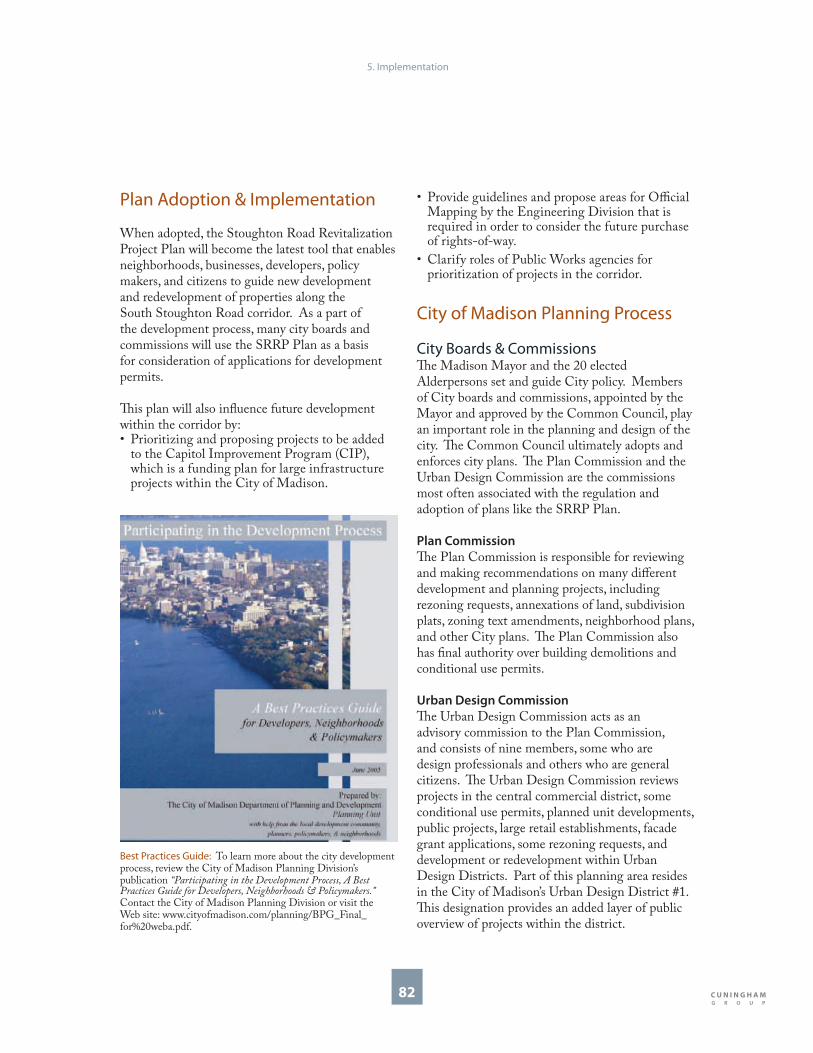
5. Implementation
82
Plan Adoption & Implementation
When adopted, the Stoughton Road Revitalization Project Plan will become the latest tool that enables neighborhoods, businesses, developers, policy makers, and citizens to guide new development and redevelopment of properties along the South Stoughton Road corridor. As a part of the development process, many city boards and commissions will use the SRRP Plan as a basis for consideration of applications for development permits.
Th is plan will also infl uence future development within the corridor by:
Prioritizing and proposing projects to be added to the Capitol Improvement Program (CIP), which is a funding plan for large infrastructure projects within the City of Madison.
•
Provide guidelines and propose areas for Offi cial Mapping by the Engineering Division that is required in order to consider the future purchase of rights-of-way.
Clarify roles of Public Works agencies for prioritization of projects in the corridor.
City of Madison Planning Process
City Boards & CommissionsTh e Madison Mayor and the 20 elected Alderpersons set and guide City policy. Members of City boards and commissions, appointed by the Mayor and approved by the Common Council, play an important role in the planning and design of the city. Th e Common Council ultimately adopts and enforces city plans. Th e Plan Commission and the Urban Design Commission are the commissions most often associated with the regulation and adoption of plans like the SRRP Plan.
Plan Commission
Th e Plan Commission is responsible for reviewing and making recommendations on many diff erent development and planning projects, including rezoning requests, annexations of land, subdivision plats, zoning text amendments, neighborhood plans, and other City plans. Th e Plan Commission also has fi nal authority over building demolitions and conditional use permits.
Urban Design Commission
Th e Urban Design Commission acts as an advisory commission to the Plan Commission, and consists of nine members, some who are design professionals and others who are general citizens. Th e Urban Design Commission reviews projects in the central commercial district, some conditional use permits, planned unit developments, public projects, large retail establishments, facade grant applications, some rezoning requests, and development or redevelopment within Urban Design Districts. Part of this planning area resides in the City of Madison’s Urban Design District #1. Th is designation provides an added layer of public overview of projects within the district.
•
•
Best Practices Guide: To learn more about the city development process, review the City of Madison Planning Division’s publication “Participating in the Development Process, A Best Practices Guide for Developers, Neighborhoods & Policymakers.” Contact the City of Madison Planning Division or visit the Web site: www.cityofmadison.com/planning/BPG_Final_for%20weba.pdf.

5. Implementation
83
City PlansCity planning documents relating to land use are available and can be consulted by anyone interested in exploring the land use and design recommendations for any development site. Th e most important sources of land use information are the Comprehensive Plan, the Zoning Ordinance, and Neighborhood and Special Area Plans. Th is Stoughton Road Revitalization Project Plan, when adopted, will become advisory to the Comprehensive Plan and will be one of the many plans that infl uence development and redevelopment in the City of Madison.
Comprehensive Plan
Th e Comprehensive Plan is the City of Madison’s overall policy toward long-term land use and physical development. It provides recommendations for the use of land and for the provision of infrastructure, facilities, and services that support land uses.
Th e City of Madison Comprehensive Plan establishes an urban development strategy and policies to guide the future growth and development of the community over the next two decades. Th e Comprehensive Plan assesses existing conditions and trends and provides recommendations for the use and development of land, the extension and improvement of transportation services and infrastructure, the development of community facilities, the expansion of the city’s economic base, the provision of housing, and the protection of natural resources.
Th e Comprehensive Plan has a long-range perspective, and is a policy document that provides a coordinated approach to making many decisions regarding land use and the location of development, the extension of urban services and the placement of community facilities. As such, the Comprehensive Plan is one of the primary tools used by the Madison Plan Commission, the Common Council, the Mayor, and City staff to make decisions that aff ect the future of the community.
Th e Comprehensive Plan also supplements and updates the City’s existing city-wide master plan elements, which have been developed over time and which, in turn, provide the planning framework for more detailed special interest and special area plans that are also often adopted as elements of the city master plan. Th e City currently has more than 45 adopted elements of its master plan, including general and special transportation plans; more than thirty neighborhood and special area plans, including plans for established neighborhoods, new neighborhoods on the edge of the city, and plans such as Downtown 2000; special interest plans such as the Downtown Historic Preservation Plan, and several corridor plans focused on design as well as land use issues. Th e Comprehensive Plan also will aid in the preparation of revised and updated land development regulations such as the Zoning Code.
More information, including land use maps and the entire text of the Comprehensive Plan, may be found at: www.madisonplan.org.
Neighborhood and Special Area Plans
Th e SRRP Plan is considered a Neighborhood and Special Area Plan. Th ese plans typically include more detailed recommendations regarding new development, redevelopment, and preservation of existing neighborhoods than the Comprehensive Plan.
Unlike a zoning code, which is a legal code, Neighborhood and Special Area plans are often advisory and act as a guide for development. Neighborhood Plans, however, do hold great infl uence over development projects and infrastructure development. Th ese plans are a means to convey a vision for the future of a neighborhood or corridor and make specifi c land use and design recommendations that are the basis of information for how the Urban Design Commission, the Plan Commission, and the Common Council consider applications for development proposals. If desired, Neighborhood and Special Area Plans often form the basis for Urban Design District creation.

5. Implementation
84
Zoning Ordinance
(Zoning Code)
As redevelopment occurs along the South Stoughton Road corridor, developers may consider rezoning as a part of a development proposal. Th e SRRP Plan, along with its land use and design recommendations, will infl uence whether or not these rezoning requests are permitted.
Th e Zoning Code details current land use requirements for every property in the city. Such details include explanations of permitted uses, building heights, and setback requirements. Th e Zoning Code also contains requirements for open space, landscaping, parking, among others. Other regulations governing land use are included in the Subdivision Ordinance, which details the requirements for sub-dividing land, and creating new developments, neighborhoods, and commercial areas. A specifi c process is used when a property owner wishes to change zoning. Th e City of Madison Zoning Code will be undergoing a major renovation in 2008 and 2009.
Zoning Map Amendment Process:Neighborhood Meetings. Th e Zoning Code is often updated and amended to allow growth and redevelopment to occur within the City of Madison. Property owners wishing to amend their zoning are required to notify neighborhood associations and the local Alderperson at least 30 days before an application for a zoning change permit is submitted to the City. If the development or redevelopment of a property is complex in size, land owners often hold one or more neighborhood meetings to get neighborhood and business input on the new development, as well as to introduce the project to adjacent landowners.
City Departmental Review. After initial neighborhood meetings have been held, the
•
•
landowner submits an offi cial zoning change application to the City’s Zoning Administrator, along with drawings and designs of the proposed development. Th ese project plans are then reviewed by various city departments, including the Engineering Division, Traffi c Engineering, Fire Department, the Water Utility, and the Department of Planning and Community and Economic Development (DPCED).
Public Hearings and Common Council Approvals. Once reviewed by these departments, the landowner goes before the City Plan Commission for a public hearing. Public hearings allow any member of the public a chance to speak for or against a project. Sometimes additional city boards and commissions are asked to advise the Plan Commission. Th e Landmarks Commission is required if the project is in a Historic District. Th e Urban Design Commission, which will be discussed in further detail, is also often advisory to the Plan Commission for zoning text changes and map amendments. Following a recommendation for approval made by the City’s Plan Commission, the landowner then goes before the City of Madison Common Council for an additional public hearing for fi nal approval.
•
Neighborhood Meetings: Neighborhood meetings are part of the zoning map amendment process.

5. Implementation
85
Sign Code Ordinance
Th e purpose of the Sign Code is to create the legal framework for a comprehensive but balanced system of street graphics, or signs on private property. Th e Sign Code is written to promote signs that are compatible with their surroundings, appropriate to the type of activity to which they pertain, expressive of the identity of individual proprietors or the community as a whole, legible, and designed so as not present any hazard to traffi c safety. Several zoning-based districts and uses have added requirements for signs and building advertisements. Th ese districts include the Central Commercial District, Historic Districts, Urban Design Districts, Planned Community Development Districts, and Planned Unit Developments.
Th e Sign Code is also currently undergoing study for a major code revision. Th e SRRP Plan and Design Guidelines will help advise the Urban Design Commission and city planning staff as they make recommendations to city boards and commissions and enforce the sign ordinance for special districts that fall within the South Stoughton Road corridor.
Sign Code Ordinance: Th e sign code can address visual clutter created by the array of signs in the corridor. Th is Plan recommends that wayfi nding, commercial, and other signs in the corridor be part of a coordinated signage eff ort that treats the overall corridor as a district.
Annexation Agreements
Th e City of Madison has a Boundary Agreement with the Town of Blooming Grove. Several areas adjacent to the corridor are currently located in the Town of Blooming Grove. Some of these areas may be annexed to the city at any time the property owner wishes to be annexed upon approval of the annexation by the Plan Commission and the Common Council. Several areas of the Town of Blooming Grove, including the small development at the northeastern corner of South Stoughton Road and Milwaukee Street, are in a protected area, as stated in the Cooperative Plan between the City of Madison and the Town of Blooming Grove. Upon the completion of a Protected Annexation Period, in November of 2027, all areas still remaining in the Town of Blooming Grove will be annexed into the City of Madison upon the approval of a fi nal annexation attachment.
Town of Blooming Grove: Several areas within the SRRP Plan study area lie within the Town of Blooming Grove.
Town of
Blooming Grove
North
Town of
Blooming Grove
North
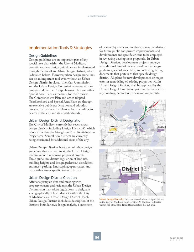
5. Implementation
86
Implementation Tools & Strategies
Design Guidelines Design guidelines are an important part of any special area plan within the City of Madison. Sometimes these design guidelines are implemented through the use of an Urban Design District, which is detailed below. However, urban design guidelines can be an important tool even without an Urban Design District in place. Th e Plan Commission and the Urban Design Commission review various projects and use the Comprehensive Plan and other Special Area Plans as the basis for their review. Th e Comprehensive Plan and other adopted Neighborhood and Special Area Plans go through an extensive public participation and adoption process that ensures that plans refl ect the values and desires of the city and its neighborhoods.
Urban Design District DesignationTh e City of Madison currently has seven urban design districts, including Design District #1, which is located within the Stoughton Road Revitalization Project area. Several new districts are currently being considered for additional areas of the city.
Urban Design Districts have a set of urban design guidelines that are used to aid the Urban Design Commission in reviewing proposed projects. Th ese guidelines discuss regulation of land use, building heights and design, pedestrian circulation, entrances, parking, landscaping, open spaces, and many other issues specifi c to each district.
Urban Design District CreationAfter analyzing an area and meeting with property owners and residents, the Urban Design Commission may adopt regulations to designate a geographically defi ned district within the City of Madison as an Urban Design District. Each Urban Design District includes a description of the district’s boundaries, a design analysis, a statement
of design objectives and methods, recommendations for future public and private improvements, and developments and specifi c criteria to be employed in reviewing development proposals. In Urban Design Districts, development projects undergo an additional level of review based on the design guidelines, special area plans, and other regulating documents that pertain to that specifi c design district. All plans for new developments, or major exterior remodeling of existing properties within Urban Design Districts, shall be approved by the Urban Design Commission prior to the issuance of any building, demolition, or excavation permits.
Urban Design Districts: Th ere are seven Urban Design Districts in the City of Madison (top). District #1 (bottom) is located within the Stoughton Road Revitalization Project area.
North
North

5. Implementation
87
City Grant ProgramsTh e City of Madison sponsors several grant programs to help strengthen and enhance City Neighborhoods and Business Districts. Facade Improvement Grant Program
Th e Community Development Authority (CDA), along with support from the Department of Planning and Community and Economic Development (DPCED) sponsors the Facade Improvement Grant Program.
At this time, properties located along the South Stoughton Road corridor are not eligible for Facade Improvements Grants, as the corridor is not listed in the target area. However, as redevelopment occurs, the CDA may consider this corridor to be an area eligible for Facade Improvement Grants, as other projects outside of the target area have been considered in the past. Th is Plan recommends that businesses in this district, working towards a more compact, walk-able, and attractive streetscape, be eligible for facade grants.
Attractive building facades support and encourage local businesses, and have a signifi cant eff ect on the attractiveness and marketability of the surrounding area. To encourage business owners to reinvest in the downtown and smaller neighborhood shopping and business areas, the CDA off ers matching grants to assist in exterior renovations of these otherwise sound and vital properties.
Properties that are used in whole or part for service or commercial activities are eligible for funding. Th e program is intended to assist projects that promote retail activities, create an attractive environment, encourage neighborhood character and architectural design, use high-quality materials, and incorporate good design concepts. Projects meeting these objectives may be eligible for a Facade Improvement Grant. Grants will be provided in an amount up to 50 percent of the total project cost, to a maximum of $10,000 per street facing facade. Maximum amounts would range to $10,000 for a single facade, $20,000 for a building with two facades, and $25,000 for “fl atiron”
buildings. Th e owner/tenant must use private, non-City funds to match the City’s grant.
Grants may be used for restoring or substantially beautifying or enhancing the entire facade or elevation of a commercial building. Eligible items include uncovering and restoring historical facades, removing existing facade materials and replacing them with more appropriate and attractive designs and materials, and other detailing which leads to a substantially enhanced appearance.
For more information on Th e City of Madison’s Facade Improvement Program, please contact the Community Development Authority, or the City of Madison Department of Planning and Community and Economic Development.
Facade Improvement Grant Before/After: Th is locally-owned greenhouse is on the 18/151 Beltline Highway. Although it is not in the Facade Grant target area, it was deemed eligible for a Facade Improvement Grant. Photos show the greenhouse before (top) and after (bottom) facade improvements.

5. Implementation
88
Neighborhood Grants Program
Th e City of Madison Planning Division administers the Neighborhood Grant Program. Th is Program off ers neighborhood associations and Business District Associations an opportunity to apply for funding to engage residents, business owners and other groups in activities and projects aimed to strengthen their neighborhoods. Th ese projects can take the form of leadership and capacity building initiatives, or physical community enhancement projects. Th ere are several opportunities for any of the eight diff erent neighborhoods or the Southeast Business District Association adjacent to the Stoughton Road corridor to apply for Neighborhood Grant funding. Landscaping projects, leadership building activities, sustainable design kiosks, or pilot projects and streetscape improvements are among the many neighborhood grant eligible projects discussed in this Plan.
Th ere are two sizes of neighborhood grants available. Mini Grants are awarded up to $2000 and have no match requirement. Neighborhood Grants for larger, more complex projects and activities are awarded up to $20,000 and have a fl exible match requirement based on the resources available within, and to, the neighborhood. Grants are available to fund the following eligible projects and activities:
Community Enhancement. Community Enhancement Grants are intended to assist and encourage neighborhood–based organizations in making improvements to public places. Projects improve the appearance and livability of a neighborhood’s streetscapes, gateways, and neighborhood business areas. Such projects and activities are generally highly visible capital projects that can be undertaken and completed in a short period of time.
Neighborhood Leadership & Capacity Building. Neighborhood Leadership and Capacity Building Grants are awarded for projects and activities that improve the organizational capacity of neighborhood associations in addressing issues, improving conditions, and enhancing the quality of life within the neighborhood. Th ey are designed for
•
•
neighborhoods with active associations and leadership, as well as neighborhoods with little organizational structure or leadership.
Neighborhood Planning. Neighborhood Planning Grants are awarded to provide fi nancial assistance to neighborhood organizations to help neighborhoods strategically plan for the future. Projects and activities that will be considered include the preparation of neighborhood plans, typically focusing on matters such as land use and development standards, as well as other issues. Such plans may cover an entire neighborhood, a sub-area of the neighborhood, or a neighborhood business district.
For more information about the City of Madison Neighborhood Planning Grants, please contact the City of Madison Planning Division.
•
Neighborhood Grants Program: Some projects include the Bay Creek Informational Kiosk (1) and the Atwood Community Gardens artistic watering system (2). A neighbor helps construct another project (3).
1 2
3

5. Implementation
89
Public Art Grants Program:
Madison Arts Commission
Th e SRRP Plan outlines several areas that could benefi t from public art components, including public art installations, water features and fountains, and streetscape components within adjacent neighborhoods and along the corridor itself.
Th rough the Public Art Program, Th e Madison Arts Commission (MAC) facilitates and supports the work of artists to explore new ideas, foster dialog, and celebrate civic life. Citizens, civic events, and values are remembered and acknowledged in our public art sites. Th e MAC is committed to strengthening the integration of public art into the public realm. Th ere are several diff erent Art Grants available each year.
Project Grants. Th e Annual Project Grants provide support for arts projects, performances, exhibitions or events that enrich the cultural lives of Madison’s residents. Grants are awarded in amounts up to $2,500 and must be matched. Th e annual deadline is March 15.
Signature Grants. A Signature Grant is for new work. Th e commission defi nes new work as work that has never been performed, published or exhibited. Th e annual deadline is March 15.
ArtWORKS! Th e MAC is especially committed to making arts education possible for every child. ArtWORKS! Supports partnerships between artists and community groups for after-school arts based activities.
BLINK: Temporary Art Opportunities. BLINK is an opportunity for experimental, ad-hoc, temporary works of art to sprout up throughout the community and vanish leaving residents and visitors eager to see what is next. Th e possibilities for creations on open spaces, construction sites, and public parks will provide a glimpse of how the world looks through an artist’s eyes.
Please Contact the Madison Arts Commission for more information on Municipal Public Art Opportunities.
•
•
•
•
Public Art Projects: Th e Madison Arts Commission funded a project by Stephen Fischer (1) to improve the aesthetic quality of the intersection of Broadway and Bridge Roads. Th e Capitol Square Fountains were done by Sven Schunemann and Heidi Natura (2), and the Madison Water Utility Building project was done by Gail Simpson (3).
1
2
3

5. Implementation
90
Economic Development &Business Support
Economic Development Division
Th e Economic Development Division of the Department of Planning and Community and Economic Development (DPCED) is highly involved with business support, city real estate, and economic development support for the City.
Th is division manages Tax Incremental Financing Districts, large development projects and the development of community facilities, acquisition of property for community facilities, and public rights-of-way. It also administers public fi nancial support through programs and tools as Industrial Revenue Bonds, and the Capital Revolving Fund Program. Th e Capital Revolving Fund is used to promote economic growth and development and has three main goals:
Encouraging the expansion of new and existing business enterprises that create jobs for unemployed and underemployed people.
Preserving and expanding the housing supply within the City, including market rate housing and aff ordable housing for low- and moderate-income households.
Redeveloping blighted and under-utilized properties for uses consistent with a strategy for neighborhood and downtown revitalization.
Th e Economic Development Division also helps to coordinate the City’s Facade Grant Program through the City of Madison’s Community Development Authority. For more information on TIF Districts, Industrial Bonds or the Capital Revolving Fund. Please contact the Economic Development Division.
•
•
•
Community Development Block Grant Offi ce
Th e Community Development Block Grant Offi ce (CDBG) Offi ce is a federally funded public investment agency within the Madison Department of Planning and Community and Economic Development that works with community-based non-profi t organizations to improve the quality of life for Madison’s low- and moderate-income people and neighborhoods. CDBG is involved in community planning initiatives, grant programs and other tools to encourage neighborhood health. Two of the programs administered by CDBG may be found useful during the redevelopment opportunities within the South Stoughton Road Corridor, Economic Development of Micro-Enterprises and Business Growth for Job Creation.
Th ese programs provide business loans and technical assistance for business start-up and expansion to lower income entrepreneurs or to very small businesses operating within targeted neighborhoods. Th ese activities help existing businesses grow to create jobs for lower income persons. One example of CDBG’s business support success is the Madison Enterprise Center on South Baldwin Street in Madison. CDBG, in partnership with Common Wealth Development, created this business incubator that off ers low cost space and technical assistance to small start-up businesses.
Madison Enterprise Center: Th is business incubator functions as a collaborative center that supports businesses entrepreneurs. Th e Stoughton Road corridor could be a prime location for a new tech incubator where new businesses co-locate with other industries and employers in the district.

5. Implementation
91
Wisconsin BioAg Gateway: Stoughton Road is the main access to the Wisconsin Bio Ag Gateway.
Offi ce of Business Resources
Th e Offi ce of Business Resources (OBR) is a central point of contact for business assistance in the City of Madison. OBR services serve new start-up operations and assist businesses developing and thriving in Madison. OBR works with entrepreneurs and businesses providing business start-up, retention, expansion, attraction, and technical assistance services.
Th e Offi ce of Business Resources also staff s the City’s Economic Development Commission. Th e City and the Commission is working on a new Economic Development Plan in 2008. Th is new Economic Development Plan may provide some implementation ideas and tools that will be useful as the City begins to implement the SRRP Plan.
BioAg Gateway. Th e SRRP Plan emphasizes the opportunities that can occur along the corridor and in the Gateway Development Area at the south end of the Corridor. Th e Offi ce of Business Resources has also played a large role in the development of the Wisconsin BioAg Gateway located just east of the South Stoughton Road Corridor, and accessed off of the East Broadway intersection. Th is technology and employment center gives Stoughton Road the opportunity to provide essential services and economic development growth. Th e SRRP Plan provides complementary development opportunities for the BioAg Gateway.
Business Support. If businesses are interested in learning more about economic development opportunities, including fi nancial aid, site selection, laboratory and incubator space, business planning assistance, business organizations, permitting and licensing, community information, and demographic information, please contact the Offi ce of Business Resources.

5. Implementation
92
Tax Incremental Financing DistrictsTh e City of Madison’s Economic Development Division facilitates and coordinates the City of Madison Tax Incremental Financing Districts. Tax Incremental Financing (TIF) is a governmental fi nance tool that the City of Madison uses to provide funds to construct public infrastructure, promote development opportunities, and expand the tax base.
TIF assistance in Madison is used only when the proposed development would not occur “but for” City assistance. Th e proposed development should be consistent with and reinforce all City plans and lead to the redevelopment of underutilized properties. TIF Districts in Madison have three general goals:
Support the Downtown.
Support Neighborhood Revitalization.
Support Economic Development.
Th e current TIF District #24, within and adjacent to the Gateway Development Area of the SRRP Plan, was used to promote and support economic development in the district. Th is TIF District has fulfi lled its proposed infrastructure projects and is proposed to be closed in 2008. With the adoption of this Project Plan, the City is currently proposing the creation of a new Economic Development TIF district for the corridor and surrounding industrial and employment district. Once this potential district’s boundaries are fi nalized, any new TIF District will need approval by the local taxing jurisdictions. Upon approval, TIF funds could be used to help promote economic development and growth along the corridor, including, but not limited to, the following tools and expenditures:
Street and Infrastructure Improvements including landscaping and other Capital Improvements.
Business Marketing & Business Expansions.
Promote higher standards of Building Design.
Any new TIF District in the area will most likely
•
•
•
•
•
•
encompass most of the Gateway Development Area, as well as some of the Grid Development Area within the SRRP Plan boundaries. Th is new district would include many areas that had not been redeveloped during the previous TIF District.
Some projects that could be funded by TIF dollars are listed below. Specifi c Information about the City of Madison’s TIF District Standards can be found by contacting the Department of Planning and Economic and Community Development.
Possible TIF District Funded ProjectsGrid Development Area
Transportation infrastructure: bridge design, median and frontage road landscaping, transit shelters, bicycle lanes, new street connections.
Urban design elements: wayfi nding, public art, lighting and banners, sidewalks, gateway elements for neighborhood entrances.
Open space improvements: gateway landscaping at neighborhood entrances, land acquisition and development for new neighborhood parks, noise barriers or landscape screening between residential uses and the highway, natural landscape restoration, trails.
Financial assistance for new development: marketing and business expansions assistance, promotion of high-quality building design.
Gateway Development AreaTransportation infrastructure: new street connections and rights-of-way acquisitions throughout new redevelopment area, sidewalks, park-n-ride lot updates and redevelopment, median and frontage road landscaping, transit shelters, bicycle lanes.
Urban design elements: wayfi nding, lighting, public art, banners, sidewalks on frontage roads, development area gateway feature.
Open space improvements: trails, urban boulevard elements, open space.
Financial assistance for new development: marketing and business expansions assistance, promotion of high-quality building design.
•
•
•
•
•
•
•
•

5. Implementation
93
Proposed TIF District #39: Th is map illustrates the proposed boundaries of the new proposed TIF District #39 (black line). Opportunities for TIF funded projects occur in both the Grid and Gateway Development Areas.
Buckeye Road
Helgesen Drive
Pfl aum Road
Cottage Grove Road
Femrite Drive
US Highway 12 -18
North
Sto
ug
hto
n R
oa
d

5. Implementation
94
Public Works & FacilitiesSpecial Area Plans help the City set priorities for infrastructure improvements. Th e Comprehensive Plan and associated Special Area Plans, like this SRRP Plan, provide a framework and guidance for the City’s fi ve-year capital improvement program. Th e Capital Improvement Program guides the expenditures of long-term investments in the city’s infrastructure. Some of these projects may include:
Repair existing streets, build new streets.
Repair and build sidewalks.
Develop and maintain parks and open space.
Libraries and other City of Madison facilities.
Streets maintenance and public works facilities.
Land conservation and acquisition.
Pedestrian and bicycle lanes and paths.
Transit facilities.
Fire and police stations.
Landscaping projects.
Sewer, water and stormwater repair and improvements including rain gardens, greenways and even wetland restoration.
Neighborhood enhancements and projects.
Public art.
Pedestrian lighting and urban amenities.
Each year, City Divisions and Departments prioritize these goals and projects for the not only the following budget year, but also for the next fi ve years. Th is helps the budgeting process by determining what large public works and Capital Improvement Projects may be anticipated in the future. Th e projects needed to accomplish the goals and priorities of this plan will be among those considered as future budgeting processes occur.
•
•
•
•
•
•
•
•
•
•
•
•
•
•
Public Works Projects: Th e Starkweather Creek pedestrian and bicycle bridge over East Washington Avenue and the Marquette neighborhood bicycle path and neighborhood sign are ublic works projects that make gateway statements and provide neighborhood and city amenities.
Solar Parking Canopy: Th is Solar Canopy adjacent to the Madison Municipal Building is an example of a partnership with Madison Gas and Electric. Th is public-private partnership creates energy and provides an attractive streetscape amenity.

5. Implementation
95
Private Eff ortsTh ere are a number of other ways private property owners can improve commercial areas, industrial areas, and neighborhoods. In fact, many property owners in the SRRP Plan study area have done so. Owners who enrich their property’s aesthetics, improve the patron experience, and add positive elements to the overall appearance of the Stoughton Road corridor area. Some properties have become destinations because of such eff orts. Property owners have, and can continue to:
Redevelop property.
Update and improve lighting.
Update and improve signs.
Improve facades and building aesthetics.
Plant trees and add landscaping.
Repair and improve parking lots with pedestrian walkways, parking lot edges, and parking lot landscaping.
Improve parking and building entries.
Add on to buildings with high quality architecture and materials.
Engage in public-private partnerships to add urban amenities, coordinate curb-cuts, showcase pilot projects, and coordinate with telecom companies.
Engage in philanthropy to help with local charities and other neighborhood eff orts.
•
•
•
•
•
•
•
•
•
•
SRRP Plan Area Private Properties: Th e Drexel Interiors building (top) has an updated facade and well-tended landscaping. A parking lot in the Fen Oak area (bottom) uses wetland plantings and swales to manage stormwater and to improve parking lot aesthetics.

5. Implementation
96
Short-Term Implementation
Short-Term implementation eff orts include projects and initiatives that could begin immediately. Th ese eff orts do not have to wait for WisDOT’s Highway 51 reconstruction.
Communication & Planning Initiatives
Engage the corridor’s development community in the 2008 Economic Development Plan.
Continue dialogue between neighborhood associations, other groups, city staff , and WisDOT throughout the Environmental Impact Statement (EIS) and reconstruction of US Hwy 51 planning process.
Encourage coordination between the SRRP Plan and future planning eff orts along the corridor, including the Royster Clark Special Area Plan.
Encourage rental property and business owners along the corridor to become more active in neighborhood associations as part of eff orts to increase communication in the neighborhoods.
Support new TIF District creation that includes the Grid and Gateway Development Areas.
Update design guidelines for Urban Design District #1 and amend the district boundaries to include a larger area of the South Stoughton Road corridor.
Encourage the Community Development Authority (CDA) to include Stoughton Road as a targeted area for Facade Improvement Grants.
Request that the Traffi c Engineering Division assist neighborhoods to create Neighborhood Transportation Management Programs to reduce speed and volume of traffi c on cut-through routes and other problem areas. Th ese include Allis Avenue and adjacent streets to the west, and Dondee Road and Acewood Drive on the east.
Encourage sustainable practices in the corridor by preparing a Sustainable Corridor Initiative to coincide with the marketing eff orts of the Wisconsin Bio Ag Gateway Initiative.
Strengthen the Southeast Business Association and/or create a sub-district for business and property owners along the corridor. Th is group can help improve organization and communication during the WisDOT
•
•
•
•
•
•
•
•
•
•
construction planning process and future redevelopment opportunities along the corridor.
Land Use
In the Gateway Development Area and elsewhere in the corridor, several properties still have old county zoning designation. As the City’s zoning code is rewritten, update these areas to refl ect current conditions and future potential uses according to this Plan and the City’s Comprehensive Plan.
Change Comprehensive Plan land use designation for the following in the Grid Development Area:
NE, NW, and SW corners of the intersection of Buckeye and South Stoughton Roads: Change from GeneralCommercial to Community Mixed-Use.
NE corner of Pfl aum and South Stoughton Roads: Change from General Commercial toEmployment.
NW and SW corners of Pfl aum and South Stoughton Roads: Change from GeneralCommercial to Community Mixed-Use.
NE Corner of Cottage Grove and South Stoughton Roads: Change from GeneralCommercial to Community Mixed-Use.
Change Comprehensive Plan land uses for the following in the Gateway Development Area:
South of Femrite Drive, between South Stoughton Road and the extension of Progress Road: Change from GeneralCommercial to General Commercial with an emphasis on Employment and business servicesmixed-uses.
South of Femrite Drive, between the extension of Progress Road and the extension of Dairy Frive: Change from General Commercial to Employment.
Th e land use recommendations in the three development areas should serve as a model for land use throughout the corridor.
Blue asterisks, used in the City’s Comprehensive Plan to designate Transit-Oriented Design, should be used as a guide to promote transit hubs and mixed-use development opportunities when land is redeveloped at these sites.
•
•
•
•
•
•
•
•
•
•
•

5. Implementation
97
Public Works Projects & Initiatives
Increase safety and security of the park-n-ride lot on East Broadway by adding more stalls, better lighting, emergency phones, and other security measures.
Request that City Traffi c Engineering and the police department improve corridor traffi c safety by installing additional speed limit signs and enforcing speed limits at Buckeye Road and Pfl aum Road intersections, as well as along Hob Street, Allis Avenue, Linda Vista Drive, and Camden, Maher and Spaanem Roads.
Request that City Traffi c Engineering and/or WisDOT update and maintain arterial road signs and wayfi nding signs at major intersections.
Request that WisDOT and the City Engineering Division install sidewalks and additional street trees along frontage roads in the corridor.
Create a wayfi nding system and gateway signs into each neighborhood and business district along the corridor. Such gateway elements could include public art, landscaping, signs, gathering spaces, and other open space elements.
•
•
•
•
•
Sidewalk Improvements: Better lighting and completion of the sidewalk network can create better aesthetics, increase safety, and encourage better interaction between neighborhoods and commercial areas.
Consider WisDOT’s three interim ideas:
Add a third left turn lane on the eastbound Beltline off -ramp turning north onto South Stoughton Road.
Build an new transition lane for entering/exiting traffi c southbound Stoughton Road between Cottage Grove and Buckeye Roads.
Build additional left and right turn lane on the westbound off -ramp at Stoughton Road.
Private Redevelopment Eff orts
Encourage both retail businesses and employers to stay and expand within the corridor.
Coordinate with local businesses in marketing eff orts to promote the SRRP Plan, and encourage residents to shop at local businesses.
Improve and update existing buildings, facades, parking lots, lighting, art, and landscaping.
Take part in seasonal displays and other aesthetic improvements, including fl owers, hanging baskets, lights, and other amenities.
Coordinate shared parking arrangements and better coordination of curb-cuts along the frontage roads.
Improve signage, including attractive ground signs and coordinated sign packages among adjacent businesses.
Encourage property and business owners to make public art a part of their buildings and landscaping designs.
Encourage property owners to voluntarily remove billboards and negotiate with telecommunications companies to place mobile phone towers on rooftops instead of on freestanding poles.
Improve communication eff orts between property owners and neighborhood associations.
Encourage existing businesses and industries to display products and information about their work in public places to showcase corridor innovation and foster continued communication.
•
•
•
•
•
•
•
•
•
•
•
•
•
•

5. Implementation
98
Medium-Term Implementation
Medium-Term implementation eff orts may have to wait until WisDOT selects a preferred alternative, but may not hve to wait for actual corridor reconstruction.
Communication & Planning Initiatives
Encourage neighborhoods, city agencies, and private land owners to continue to be a part of future planning eff orts.
Coordinate the gradual removal of billboards along the corridor.
Develop a coordinated wayfi nding system for businesses and neighborhoods during WisDOT construction on the corridor. Create and implement a comprehensive district-wide wayfi nding system that improves visual and physical access to the district once construction is complete.
Request that Traffi c Engineering assist neighborhoods to create traffi c management plans during construction on Highway 51 to alleviate problems that may arise during construction.
Develop a marketing strategy to “court” a short-list of strong long-term investment potential along the corridor, and in the Gateway Development Area. Focus this marketing strategy on soliciting businesses and types of uses that may include biotechnology and “green” technology, along with employment services and some other retail.
Encourage coordination between the University of Wisconsin, Madison Area Technical College, and other institutions to join together to create apprenticeship opportunities, pilot projects, and other coeducational opportunities along the corridor.
•
•
•
•
•
•
Land Use
Continue to coordinate redevelopment eff orts according to the general concept plan outlined in this plan. Rezoning requests and annexations should follow the guidelines of this Plan.
Encourage TODs and Community Mixed-Use Districts continue to guide development at intersections.
Redevelop multi-family uses on Camden Road as part of an overall mixed-use development that encourages new and improved residential uses on Camden, and commercial and employment uses facing the Stoughton Road corridor.
Designate a small area as parks and open space if redevelopment occurs and Hob Street is extended toward the frontage road.
•
•
•
•
Encourage Sustainable Practices: Promote conservation eff orts of local wetlands and open space, including additional support of the Edna Taylor Conservation park..

5. Implementation
99
Public Works Projects & Initiatives
Request that the Engineering Division, along with coordination from the business sector, explore the idea of creating pilot projects along the corridor that encourage sustainable practices. Th ese projects could include solar and/or other energy projects, rain gardens, low-energy pedestrian lighting, and other sustainable practices.
Request that the Engineering Division construct additional pedestrian and bicycle paths and access to commercial district from the neighborhoods.
Request that the Parks and Engineering Divisions create additional trail opportunities through conservation areas in the Garden Development Area adjacent to Highway 30.
Request that the Parks Division replace the neighborhood park that was lost on Spaanem Road due to the construction of the Lussier Stadium. A new neighborhood park could become part of a redevelopment opportunity at Hob Street, Allis Avenue, or somewhere else within this neighborhood.
Request that Metro Transit improve routes and public transit access to employment areas, including additional commuter routes, as development occurs.
Request that Traffi c Engineering explore the construction of bicycle lanes on Buckeye and Pfl aum Roads.
Explore potential of rails-to-trails bicycle and pedestrian paths within the railroad corridor.
Request that the Parks and Engineering Divisions continue wetland restorations and support additional conservation eff orts at Edna Taylor Conservation Park and Acewood Park Greenway and Pond, including the creation and enhancement of educational opportunities through additional park infrastructure and amenities.
Request that the Madison Arts Commission continue to support public art initiatives along the corridor, similar to that of the Gateway Project on East Broadway.
Request Engineering to acquire the necessary rights-of-way and construct new streets that will provide a better street network in the Gateway
•
•
•
•
•
•
•
•
•
•
Development Area, and promote continued development opportunities.
Request that Engineering acquire rights-of-way and extend the frontage road on the east side of the corridor from the Madison Turners Building, south toward the Gateway Development Area.
Private Redevelopment Eff orts
Encourage neighborhood associations, the Southeast Business District and local businesses and property owners to develop and plan for improved design aesthetics.
Encourage developers to sustain and restore existing natural assets within the corridor, including old growth trees, wetlands, and natural corridors.
Encourage property owners to voluntarily remove billboards and negotiate with telecommunications companies to place mobile phone towers on top of roofs instead of on freestanding poles.
Encourage property and business owners to enact an “adopt-a-highway” type of program to keep the corridor attractive and clean.
Coordinate new development opportunities between property owners.
Develop vacant or underutilized parcels to provide the catalyst for continued growth.
•
•
•
•
•
•
•
Mixed-Use Opportunities in the Grid Development Area: Th is mixed-use development in Minneapolis has retail and service uses on the ground fl oro, with residential uses on upper fl oors. Th is type of project illustrates what should be considered in the Community Mixed-Use (CMU) sections of the Grid Development Area. Art shown here is an example of a gateway element that could mark an entrance into a neighborhood.

5. Implementation
100
Long-Term Implementation
In addition to guiding short- and medium-term improvements and redevelopment eff orts, the SRRP Plan proposes improvements for future, longer-term implementation that occur once WisDOT has begun corridor reconstruction.
Communication & Planning Initiatives
If and when a Regional Transit Authority (RTA) is created, and rail transit becomes a possibility in the City of Madison, the RTA should study this corridor and existing railroad rights-of-way for potential system expansions and development opportunities.
Land Use
As Town of Blooming Grove land is annexed into the City of Madison, the land adjacent to the Milwaukee Street Intersection in the Garden Development Area should be designated Neighborhood Mixed-Use (NMU) near Milwaukee Street with low-density residential behind.
As Town of Blooming Grove land is annexed into the City of Madison, the current public works facility located off of the frontage road and Allis Avenue should be designated as either Community Mixed-Use (CMU) or General Commercial. Since this is currently publicly owned property, this land may provide an opportunity for continued public ownership. It could be an urban square as part of a larger redevelopment eff ort or it could remain a public works facility.
Public Works Projects & Initiatives
Request Traffi c Engineering and Engineering Divisions coordinate eff orts with WisDOT to construct well-designed bridges and street lighting for cross streets in the depressed roadway section between Buckeye and Pfl aum Roads. Th ese bridges should have high-level pedestrian amenities and should be an attractive feature that adds to the distinction of the corridor.
Design and build additional pedestrian and
•
•
•
•
•
bicycle connections to connect across the highway once the depressed roadway between Pfl aum and Buckeye Roads is either completed or a diff erent alternative is selected.
Construct landscape screening along the backsides of both residential and commercial frontages once highway reconstruction is complete.
Develop a strategy for appropriate, aesthetically pleasing noise reduction initiatives. Th e City and WisDOT should consider berms, landscaping, and quiet road materials instead of unattractive noise barriers.
Right-of-way/property acquisition:
Th e SRRP Plan will continue to be a guide that will help the city prioritize infrastructure and public redevelopment opportunities. Th e Plan will guide varied departments, including the Parks Division, the Engineering and Traffi c Engineering Divisions, and the Department of Planning and Community and Economic Development as the need for property and right-of-way acquisition occurs.
Request that City of Madison Parks and Engineering Divisions continue eff orts to restore wetlands and create trails to become a part of the open space network, as well as increase sustainable stormwater capacity ad infi ltration.
Encourage Traffi c Engineering and WisDOT to redevelop the existing East Broadway park-n-ride lot. Th e lot could be part of a larger redevelopment project, and could include structured parking, gathering spaces, and could be shared between adjacent uses. Maintain high levels of security, safety, and pedestrian amenities.
Private Redevelopment Eff orts
Long term redevelopment opportunities and coordination of development can occur after WisDOT has reconstructed the corridor.
Th e development community can continue to market this area as a Gateway Corridor, and encourage high quality, job-producing development that will allow the East Side and the whole city to continue to fl ourish.
•
•
•
•
•
•
•

5. Implementation
101
Continued Implementation Eff orts
Successful implementation, whether it is short-term, medium-term, or long-term in scope, relies on a collaborative eff ort among public and private stakeholders. Th e SRRP Plan process began as a grassroots partnership, led by the neighborhoods in conjunction with public entities, and Plan implementation should continue helping form such public-private partnerships.
Th is Plan is only the beginning of a long eff ort
to revitalize this East Side corridor and create opportunities for new employment, retail, services and technology. As technology evolves, this corridor can continue to serve both local and regional needs, and become a model for other corridors to showcase neighborhood connectivity, open space, biotechnology, and sustainability.
Th e Plan should continue to raise investor confi dence and inspire new ideas to fulfi ll the shared vision of a promising future for the East Side of Madison.