re: proposed carport at 141 davidson street, port douglas ......applicant: the shed company, c/...
TRANSCRIPT

04th September 2019 Douglas Shire Regional Council PO Box 359 CAIRNS Q 4870 Attention: Planning Section Dear Sir/Madam, Re: Proposed carport at 141 Davidson Street, Port Douglas. Lot 7 on SP309132 Baker Building Certification has been engaged to assess an application for the proposed open carport on the abovementioned allotment. A preliminary assessment of the proposal has indicated that the proposed carport triggers assessment against the tourist and accommodation and flood and storm tide hazard overlay as outlined in the Douglas Shire Planning Scheme 2016. Applicant: The Shed Company, c/ Baker Building Certification. 6.2.14 Tourist accommodation zone code
Performance outcomes Acceptable outcomes Applicant response
For self-assessable and assessable development
Height
PO1
The height of all buildings and
structures must be in keeping with
the residential character of the
area.
AO1
Buildings and structures are not
more than 13.5 metres and 3
storeys in height.
Complies
Carport will be no greater than
4.5m and is considered single storey
in height.
Setbacks (other than for a dwelling house)
PO1
Buildings are setback to: (a)
maintain the character and amenity
of the area; (b) achieve separation
from neighbouring buildings and
from road frontages.
AO1
Buildings are setback: (a) a
minimum of 6 metres from the
main street frontage; (b) a
minimum of 4 metres from any
secondary street frontage; (c) 4.5
metres from a rear boundary; (d) 2
metres from a side or an average of
half of the height of the building at
Proposed
Carport is proposed to be setback
>6m rom the road frontage and
200mm from the right and left side
boundaries. The side boundary
encroachments will not affect the
surrounding allotments as the
proposed carport is open allowing
existing levels of light and

Performance outcomes Acceptable outcomes Applicant response
the side setback, whichever is the
greater.
ventilation to remain. The adjoining
allotments structures are also
adequately separated from the
location of the proposed open
carport.
Site coverage (other than for a dwelling house)
PO2
The site coverage of all buildings
does not result in a built form that is
bulky or visually obtrusive.
AO2
The site coverage of any building is
limited to 50% Building proportions
and scale (other than for a dwelling
Complies
The site coverage of all buildings
does not exceed 50% of the
allotment size and the proposed
carport is minor in comparison to
the existing dwelling on site.
Building proportions and scale (other than for a dwelling house)
PO3
The proportions and scale of any
development are in character with
the area and local streetscape.
AO3.1
The overall length of a building does
not exceed 30 metres and the
overall length of any continuous
wall does not exceed 15 metres.
AO3.2
Balconies, patios and similar spaces
are not enclosed or capable of
being enclosed and used as a
habitable room.
AO3.3
Balconies, patios and similar spaces
are designed to be open and light
weight in appearance with a
maximum of 20% of the façade
being fully enclosed.
AO3.4
Roof forms, materials and colours
of buildings enhance the amenity of
Complies
The proposed open carport is
consistent with the purpose and
overall outcomes sought for the
zone. The carport does not exceed
30m. No balconies are proposed
and roof colours of the proposed
carport are to match existing roof
colours in the area.
Proposed roof colour: Surfmist to
match existing.

Performance outcomes Acceptable outcomes Applicant response
the street and locality, including: (a)
the roofs of buildings are light
coloured and non-reflecting; (b)
white and shining metallic finishes
are avoided on external surfaces in
prominent view.
Note – The building incorporates building
design features and architectural elements
detailed in Planning scheme policy SC 6.2 –
Building design and architectural elements.
Landscaping (other than for a dwelling house)
PO4
Landscape planting is provided for
the recreational amenity of
residents/guests and incorporates
dominant tropical vegetation which
enhances the streetscape and the
amenity of the area.
AO4.1
A minimum of 35% of the site is
provided as open space and
recreation area with a minimum of
30% of this total; area provided for
landscape planting.
AO4.2 Within the frontage setback
area, a minimum width of 2 metres
of landscape area includes a
minimum 75% dense planting.
AO4.3
Within the side and rear setback
areas, a minimum width of 1.5
metres of landscape area includes
75% dense planting.
Complies
The site coverage of all buildings
and structures and associated
services will not have an adverse
effect on the scenic values of the
site, site cover will be no more than
50% in total.
Existing landscaping will remain and
any removed to construct the
carport will be re-installed.
PO5
The establishment of uses is
consistent with the outcomes
sought for the Tourist
accommodation zone and protects
the zone from the intrusion of
inconsistent uses.
AO5
Inconsistent uses as identified in
Table 6.2.14.3.b are not established
in the Tourist accommodation zone.
Complies
The proposed carport is consistent
with the outcomes sought for the
Tourist accommodation zone and
protects the zone from the
intrusion of inconsistent uses. Other
carports are within the Tourist
accommodation zone.

Performance outcomes Acceptable outcomes Applicant response
PO6
Development is located, designed,
operated and managed to
respond to the characteristics,
features and constraints of the
site and surrounds.
Note – Planning scheme policy – Site
assessments provides guidance on
identifying the characteristics, features and
constraints of a site and its surrounds.
AO6
No acceptable outcomes are
prescribed.
Complies,
Development is located on an
existing flat level building pad.
PO7
Development does not adversely
affect the tropical, tourist and
residential character and amenity of
the area in terms of traffic, noise,
dust, odour, lighting or other
physical or environmental impacts.
AO7
No acceptable outcomes are
prescribed.
Complies A 49m2 open carport will not adversely affect the tropical, tourist and residential character and amenity of the area in terms of traffic, noise, dust, odour, lighting or other physical or environmental impacts.

Performance outcomes Acceptable outcomes Applicant response
PO9
Tourist developments include
recreational and ancillary services
and facilities for the enjoyment of
guests.
AO9.1
Development which includes
accommodation for tourists
incorporates a mix of the following
recreational and ancillary services
and facilities: (a) swimming pools;
(b) tennis courts; (c) barbecue
areas; (d) outdoor lounging /
recreation areas; (e) restaurants /
bars; (f) tourist-focussed shopping;
(g) tour booking office; (h) spa /
health clubs.
AO9.2
Any commercial services or facilities
incorporated into a tourist
development are small scale and
predominantly service in-house
guests only.
AO9.3
Where a commercial service or
facility offers services to persons
over and above in-house guests, the
commercial component provides
onsite car parking for 50% of the
floor area available for use in
accordance with the relevant
requirements of the Parking and
access code
Complies
Existing facilities are on site, the
proposed carport does not trigger
the needs for existing facilities to be
upgraded. The proposed carport is
an additional parking facility. The
allotment would not be deemed
commercial use.
PO10
New lots contain a minimum area
of 1000m2.
AO10
No acceptable outcomes are
prescribed
N/A
The lot was previously approved by
council. The proposed is for an
open carport only.
PO11 AO11 N/A

Performance outcomes Acceptable outcomes Applicant response
New lots have a minimum road
frontage of 20 metres.
No acceptable outcomes are
prescribed.
The lot was previously approved by
council. The proposed is for an
open carport only.
PO12
New lots contain a 25 metre x 20
metre rectangle.
AO12
No acceptable outcomes are
prescribed
N/A
The lot was previously approved by
council. The proposed is for an
open carport only.

8.2.4 Flood and storm tide hazard overlay code
Performance outcomes Acceptable outcomes Applicant response
For self-assessable and assessable development
PO1
Development is located and
designed to: ensure the safety of all
persons; minimise damage to the
development and contents of
buildings; provide suitable amenity;
minimise disruption to residents,
recovery time, and rebuilding or
restoration costs after inundation
events. Note – For assessable
development within the flood plain
assessment sub-category, a flood
study by a suitably qualified
professional is required to identify
compliance with the intent of the
acceptable outcome.
AO1.1
Development is sited on parts of
the land that is not within the Flood
and Storm tide hazards overlay
maps contained in Schedule 2; or
For dwelling houses,
AO1.2
Development within the Flood and
Storm Tide hazards overlay maps
(excluding the Flood plain
assessment sub-category) is
designed to provide immunity to
the Defined Inundation Event as
outlined within Table 8.2.4.3.b plus
a freeboard of 300mm.
AO1.3
New buildings are: (a) not located
within the overlay area; (b) located
on the highest part of the site to
minimise entrance of flood waters;
(c) provided with clear and direct
pedestrian and vehicle evacuation
routes off the site.
AO1.4
In non urban areas, buildings and
infrastructure are set back 50
metres from natural riparian
corridors to maintain their natural
function of reducing velocity of
floodwaters.
Proposed
The proposed carport complies with
the QDC MP 3.5. In effect as the
structure is considered a non-
habitable structure assessment
against the flood overlay is not
triggered. The structure is also open
in effect allowing any stormwater
discharge to flow reducing the risk
of collapse of the carport that may
potentially damage surround
infrastructure in the unlikely event
of a flood.
For assessable development

Performance outcomes Acceptable outcomes Applicant response
PO2
The development is compatible
with the level of risk associated
with the natural hazard.
AO2
The following uses are not located
in land inundated by the Defined
Flood Event (DFE) / Storm tide: (a)
Retirement facility; (b) Community
care facility; (c) Child care centre.
Complies
The proposed is an open carport.

Performance outcomes Acceptable outcomes Applicant response
PO3
Development siting and layout
responds to flooding potential and
maintains personal safety
For Material change of use AO3.1
New buildings are: (d) not located
within the overlay area; (e) located
on the highest part of the site to
minimise entrance of flood waters;
(f) provided with clear and direct
pedestrian and vehicle evacuation
routes off the site.
Or
AO3.2
The development incorporates an
area on site that is at least 300mm
above the highest known flood
inundation level with sufficient
space to accommodate the likely
population of the development
safely for a relatively short time
until flash flooding subsides or
people can be evacuated.
or
AO3.3
Where involving an extension to an
existing dwelling house that is
situated below DFE /Storm tide, the
maximum size of the extension
does not exceed 70m2 gross floor
area. Note – If part of the site is
outside the Hazard Overlay area,
this is the preferred location of all
buildings. For Reconfiguring a lot
AO3.4
Additional lots: (a) are not located
in the hazard overlay area; or (b)
are demonstrated to be above the
flood level identified for the site.
Note - If part of the site is outside
the Hazard Overlay area, this is the
Proposed
The proposed carport complies with
the QDC MP 3.5. In effect as the
structure is considered a non-
habitable structure assessment
against the flood overlay is not
triggered. The structure is also open
in effect allowing any stormwater
discharge to flow reducing the risk
of collapse of the carport that may
potentially damage surround
infrastructure in the unlikely event
of a flood.
The carport is no bigger than 50m2
and does not result in an
intensification of residential uses
within the flood affected areas on
land situated below the DFE/Storm
tide.

Performance outcomes Acceptable outcomes Applicant response
preferred location for all lots
(excluding park or other open space
and recreation lots). Note –
Buildings subsequently developed
on the lots will need to comply with
the relevant building assessment
provisions under the Building Act
1975.
AO3.5
Road and/or pathway layout
ensures residents are not physically
isolated from adjacent flood free
urban areas and provides a safe
and clear evacuation route path: (a)
by locating entry points into the
reconfiguration above the flood
level and avoiding culs-de-sac or
other non-permeable layouts; and
(b) by direct and simple routes to
main carriageways.
AO3.6
Signage is provided on site
(regardless of whether the land is in
public or private ownership)
indicating the position and path of
all safe evacuation routes off the
site and if the site contains, or is
within 100m of a floodable
waterway, hazard warning signage
and depth indicators are also
provided at key hazard points, such
as at floodway crossings or
entrances to low-lying reserves.
Or
AO3.7
There is no intensification of
residential uses within the flood
affected areas on land situated

Performance outcomes Acceptable outcomes Applicant response
below the DFE/Storm tide.
For Material change of use
(Residential uses)
AO3.1
The design and layout of buildings
used for residential purposes
minimise risk from flooding by
providing:
(a) parking and other low
intensive, nonhabitable
uses at ground level;
Note - The high-set ‘Queenslander’ style
house is a resilient low-density housing
solution in floodplain areas. Higher density
residential development should ensure only
nonhabitable rooms (e.g. garages,
laundries) are located on the ground floor.
Complies
The proposed open carport is
located on existing ground levels.
PO5
Development directly, indirectly
and cumulatively avoids any
increase in water flow velocity or
flood level and does not increase
the potential flood damage either
on site or on other properties. Note
– Berms and mounds are
considered to be an undesirable
built form outcome and are not
supported.
For Operational works
AO5.1
Works in urban areas associated
with the proposed development do
not involve: (a) any physical
alteration to a watercourse or
floodway including vegetation
clearing; or (b) a net increase in
filling (including berms and
mounds).
AO5.2
Works (including buildings and
earthworks) in non urban areas
either: (a) do not involve a net
increase in filling greater than 50m3
; or (b) do not result in any
reductions of on-site flood storage
capacity and contain within the
subject site any changes to
Complies
The proposed carport is open in
effect allowing existing levels water
flow velocity to move in its natural
path of travel. No fill is required to
construct the open carport, and
very little excavation for the pier
holes.

Performance outcomes Acceptable outcomes Applicant response
depth/duration/velocity of flood
waters; or (c) do not change flood
characteristics outside the subject
site in ways that result in: (i) loss of
flood storage; (ii) loss of/changes to
flow paths; (iii) acceleration or
retardation of flows or any
reduction in flood warning times
elsewhere on the flood plain.
For Material change of use
AO5.3
Where development is located in an
area affected by DFE/Storm tide, a
hydraulic and hydrology report,
prepared by a suitably qualified
professional, demonstrates that the
development maintains the flood
storage capacity on the subject site;
and (a) does not increase the
volume, velocity, concentration of
flow path alignment of stormwater
flow across sites upstream,
downstream or in the general
vicinity of the subject site; and (b)
does not increase ponding on sites
upstream, downstream or in the
general vicinity of the subject site.
For Material change of use and
Reconfiguring a lot
AO5.4
In non-urban areas, buildings and
infrastructure are set back 50
metres from natural riparian
corridors to maintain their natural
function of reducing velocity of
floodwaters.
Note – Fences and irrigation infrastructure
(e.g. irrigation tape) in rural areas should be
managed to minimise adverse the impacts

Performance outcomes Acceptable outcomes Applicant response
that they may have on downstream
properties in the event of a flood.
PO6
Development avoids the release of
hazardous materials into
floodwaters.
For Material change of use
AO6.1
Materials manufactured or stored
on site are not hazardous or
noxious, or comprise materials that
may cause a detrimental effect on
the environment if discharged in a
flood event;
or
AO6.2
If a DFE level is adopted, structures
used for the manufacture or
storage of hazardous materials are:
(a) located above the DFE level; or
(b) designed to prevent the
intrusion of floodwaters. AO6.3
Infrastructure is designed and
constructed to resist hydrostatic
and hydrodynamic forces as a result
of inundation by the DFE.
AO6.4
If a flood level is not adopted,
hazardous materials and their
manufacturing equipment are
located on the highest part of the
site to enhance flood immunity and
designed to prevent the intrusion of
floodwaters.
Note – Refer to Work Health and Safety Act
2011 and associated Regulation and
Guidelines, the Environmental Protection
Act 1994 and the relevant building
assessment provisions under the Building
Act 1975 for requirements related to the
manufacture and storage of hazardous
Complies
The proposed carport will not
release hazardous materials into
floodwaters.

Performance outcomes Acceptable outcomes Applicant response
materials.
PO7
The development supports, and
does not unduly burden, disaster
management response or recovery
capacity and capabilities.
AO7
Development does not: (a) increase
the number of people calculated to
be at risk of flooding; (b) increase
the number of people likely to need
evacuation; (c) shorten flood
warning times; and (d) impact on
the ability of traffic to use
evacuation routes, or unreasonably
increase traffic volumes on
evacuation routes
Complies,
The proposed open carport does
not increase the risk to the number
of people affect by flood. The
carport is open to allow existing
flood waters to follow the natural
discharge paths.
PO8
Development involving community
infrastructure: (a) remains
functional to serve community need
during and immediately after a
flood event; (b) is designed, sited
and operated to avoid adverse
impacts on the community or
environment due to impacts of
flooding on infrastructure, facilities
or access and egress routes; (c)
retains essential site access during a
flood event; (d) is able to remain
functional even when other
infrastructure or services may be
compromised in a flood event.
AO8.1
The following uses are not located
on land inundated during a
DFE/Storm tide: (a) community
residence; and (b) emergency
services; and (c) residential care
facility; and (d) utility installations
involving water and sewerage
treatment plants; and (e) storage of
valuable records or items of historic
or cultural significance (e.g.
archives, museums, galleries,
libraries).
or
AO8.2
The following uses are not located
on land inundated during a 1% AEP
flood event: (a) community and
cultural facilities, including facilities
where an education and care
service under the Education and
care Services National law
(Queensland) is operated or child
care service under the Child Care
Act 2002 is conducted, (b)
N/A The proposed carport is not considered community infrastructure.

Performance outcomes Acceptable outcomes Applicant response
community centres; (c) meeting
halls; (d) galleries; (e) libraries.
The following uses are not located
on land inundated during a 0.5%
AEP flood event. (a) emergency
shelters; (b) police facilities; (c) sub
stations; (d) water treatment plant
The following uses are not located
on land inundated during a 0.2%
AEP flood event: (a) correctional
facilities; (b) emergency services; (c)
power stations; (d) major switch
yards.
and/or
AO8.3
The following uses have direct
access to low hazard evacuation
routes as defined in Table 8.2.4.3.c:
(a) community residence; and (b)
emergency services; and (c)
hospitals; and (d) residential care
facility; and (e) sub stations; and (f)
utility installations involving water
and sewerage treatment plants.
AO8.4
Any components of infrastructure
that are likely to fail to function or
may result in contamination when
inundated by flood, such as
electrical switch gear and motors,
telecommunications connections,
or water supply pipeline air valves
are: (a) located above DFE/Storm
tide or the highest known flood
level for the site; (b) designed and
constructed to exclude floodwater
intrusion / infiltration.

Performance outcomes Acceptable outcomes Applicant response
AO8.5
Infrastructure is designed and
constructed to resist hydrostatic
and hydrodynamic forces as a result
of inundation by a flood.
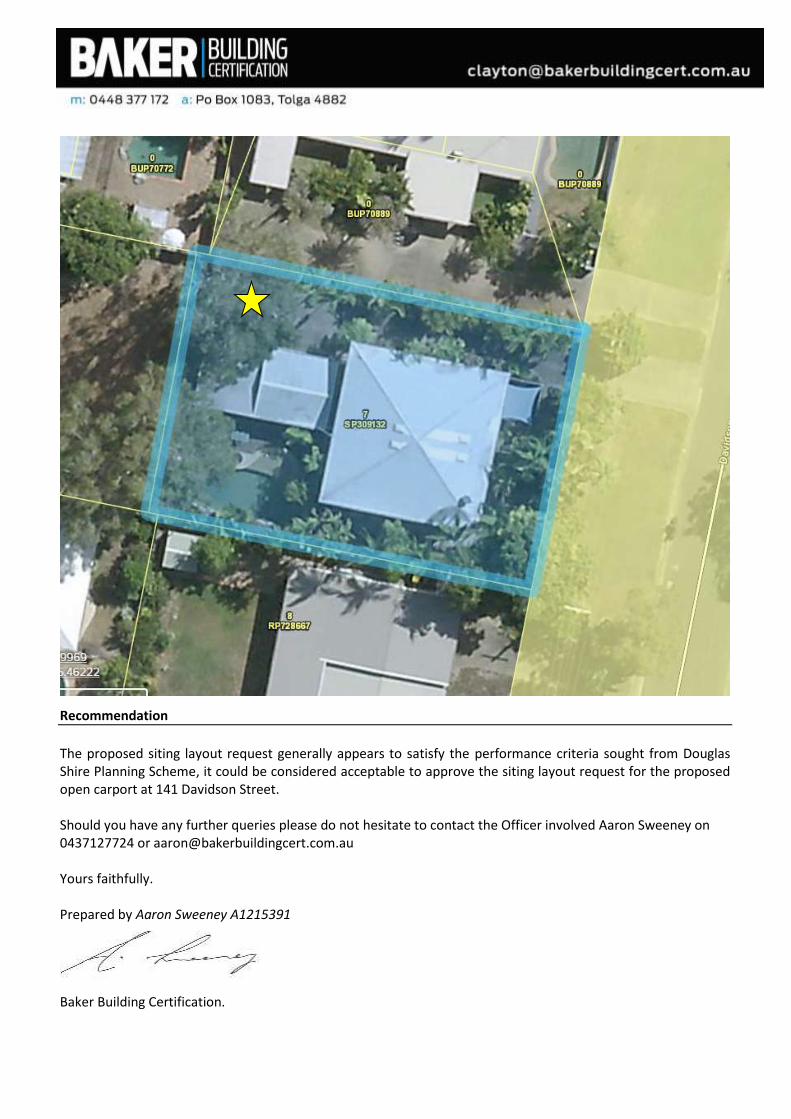
Recommendation
The proposed siting layout request generally appears to satisfy the performance criteria sought from Douglas Shire Planning Scheme, it could be considered acceptable to approve the siting layout request for the proposed open carport at 141 Davidson Street. Should you have any further queries please do not hesitate to contact the Officer involved Aaron Sweeney on 0437127724 or [email protected] Yours faithfully. Prepared by Aaron Sweeney A1215391
Baker Building Certification.


Publication Date: 12 December 2013 Page 1 MP 3.5 Construction of buildings Version: 1.2 in flood hazard areas
MP 3.5 – Construction of buildings in flood hazard areas
Contents
Part 1 Introduction 1 Purpose ....................................................................................................................................... 2
2 Commencement ........................................................................................................................... 2
3 Application .................................................................................................................................... 2
4 Limitation ...................................................................................................................................... 3
5 Referral agency ............................................................................................................................ 3
6 Compliance with the QDC ............................................................................................................ 4
7 Associated requirements.............................................................................................................. 4
Part 2 Interpretation 8 What is defined flood level ........................................................................................................... 4
9 What is freeboard ........................................................................................................................ 5
10 What is maximum flow velocity ................................................................................................... 5
11 Definitions .................................................................................................................................. 5
Part 3 Performance requirements and acceptable solutions P1 Design and construction of buildings ........................................................................................... 8
P2 Design and location of utilities ..................................................................................................... 8
P3 Protection from backflow from sanitary drains ............................................................................ 9
P4 Design and location of customer dedicated substations ............................................................. 9
Version history .................................................................................................................................. 10

MP 3.5 – Construction of buildings in flood hazard areas
Publication Date: 12 December 2013 Page 2 MP 3.5 Construction of buildings Version: 1.1 in flood hazard areas
Part 1 Introduction
1 Purpose
To ensure—
(a) particular buildings located in flood hazard areas—
(i) resist flotation, collapse or significant permanent movement caused by flood water; and
(ii) safeguard occupants and other people against illness or injury caused by flood water affecting buildings; and
(iii) are protected from backflow; and
(iv) have utilities that are protected from the effects of flood water; and
(b) that a customer dedicated substation is designed or located so its ability to function effectively is not affected by flood water.
2 Commencement
This Part of the Queensland Development Code (this Part) was published on 12 December 2013 and commences on 20 December 2013.
3 Application
(1) This Part applies to the lawful carrying out of building work1 as indicated by ticks () in the relevant columns in Table 1, to the extent the building work is carried out wholly or partly within a flood hazard area and a defined flood level is declared by a local government for the flood hazard area.
Table 1 – Application of MP 3.5
Application
Performance Requirements
P1 P2 P3 P4
Construction of a new class 1 or a class 4 part of a building
Construction of a new class 2, 3, 9a or 9c building
Relocation of a class 1 building
Additions to a class 1 building where the additions constitute 50% or more of the floor area of the existing building
Additions to a class 2, 3, 9a or 9c building, or a class 4 part of a building
Construction of a new class 5, 6, 7, 8 or 9b building 1Any plumbing or drainage work mentioned in this Part is plumbing or drainage work under the Plumbing and Drainage Act 2002 and is subject to the requirements under that Act.
(2) Despite subsection (1), this Part does not apply to—
(a) a building with an importance level 4 as specified by the BCA; or

MP 3.5 – Construction of buildings in flood hazard areas
Publication Date: 12 December 2013 Page 3 MP 3.5 Construction of buildings Version: 1.1 in flood hazard areas
(b) alterations that are not additions to the floor area of an existing building; or
(c) building work that is for, or directly relates to, raising an existing building; or
(d) repairing an existing building; or
(e) adding an extra storey above an existing part of a building; or
(f) a floating building anchored to mooring piles that comply with Mandatory Part 3.1 of the QDC, performance criteria 3; or
(g) utilities for a new class 5, 6, 7, 8 or 9b building where the building’s certificate of classification states that the building is not intended to be occupied during, or in the aftermath of, a defined flood event (DFE), unless a local government has set contrary requirements for these classes of building in a local planning scheme, temporary local planning instrument or by resolution; or
(h) a building located, or proposed to be located, on a lot that is subject to—
(i) significant mudslide or significant landslide caused by rainfall or runoff, where it would be reasonable to expect that the mudslide or landslide would affect the part of the lot where the building is, or is proposed to be, located; or
(ii) storm surge.
Note—
See the Building Act, sections 36 and 37.
4 Limitation
The acceptable solution A1(a) for this Part only applies to building work carried out on a lot, or part of a lot, located in—
(a) an area with a maximum flow velocity not greater than 1.5 metres per second; or
(b) an inactive flow or backwater area.
Note— If building work does not comply with A1, an alternative solution will be required in order to ensure it complies with P1. To formulate an alternative solution, the services of a competent person may be required.
5 Referral agency
Defined flood level (1) Under section 13 of the Building Regulation, a local government may declare a DFL for all or part of a flood hazard area.
(2) If the DFL stated in a building development application is lower than the DFL declared by the local government, the local government must, as a concurrence agency, decide whether the DFL stated in the application is appropriate.
Maximum flow velocity of water (MFV) (1) Under section 13 of the Building Regulation, a local government may declare an MFV for all or part of a flood hazard area.

MP 3.5 – Construction of buildings in flood hazard areas
Publication Date: 12 December 2013 Page 4 MP 3.5 Construction of buildings Version: 1.1 in flood hazard areas
(2) If the MFV stated in a building development application is lower than the MFV declared by the local government, the local government must, as a concurrence agency, decide whether the MFV stated in the application is appropriate.
Note—
For details of the concurrence agency jurisdiction, see the Sustainable Planning Act 2009, and the Sustainable Planning Regulation 2009, schedule 7, table 1, items 30 and 31.
6 Compliance with the QDC
Under section 14 of the Building Act, building work complies with the QDC only if it complies with all relevant performance requirements under the QDC. The building work complies with a relevant performance requirement only if it achieves a relevant building solution under the QDC for the performance requirement. This can be achieved by—
(a) complying with the relevant acceptable solution for the performance requirement; or
(b) formulating an alternative solution that complies with the performance requirement or is shown to be at least equivalent to the relevant acceptable solution; or
(c) a combination of paragraphs (a) and (b).
7 Associated requirements
Building Act 1975 Building Code of Australia (BCA) Building Regulation 2006 Electricity Act 1994 Electricity Regulation 2006 Plumbing and Drainage Act 2002 Standard Plumbing and Drainage Regulation 2003 Sustainable Planning Act 2009 Sustainable Planning Regulation 2009
Part 2 Interpretation
8 What is defined flood level
(1) Defined flood level (DFL) is the level to which it is reasonably expected flood waters may rise.
(2) The DFL for a lot in a flood hazard area is—
(a) the level declared by a local government, under section 13 of the Building Regulation 2006, to be the DFL for the part of the area where the lot is located; or
(b) if the DFL stated in a building development application for the lot is lower than the DFL declared by the local government—the level stated in the application, subject to a concurrence agency's response. .
Note—
If the DFL stated in a building development application is lower than the DFL declared by the local government, the local government must, as a concurrence agency, decide whether the DFL stated in

MP 3.5 – Construction of buildings in flood hazard areas
Publication Date: 12 December 2013 Page 5 MP 3.5 Construction of buildings Version: 1.1 in flood hazard areas
the application is appropriate. (See the Sustainable Planning Regulation 2009, schedule 7, table 1, item 30.)
9 What is freeboard
(1) Freeboard is a height above the DFL that takes account of matters that may cause flood waters to rise above the DFL.
(2) The freeboard for a lot in a flood hazard area, is—
(a) if a local government has declared a freeboard for the part of the area where the lot is located, under section 13 of the Building Regulation —the height above the DFL declared to be the freeboard; or
(b) otherwise— a height of at least 300mm.
10 What is maximum flow velocity
(1) Maximum flow velocity (MFV), for all or part of a flood hazard area, is a flow velocity of water that is reasonably expected to be the maximum flow velocity of water for all or part of the area.
(2) The MFV for a lot in a flood hazard area is—
(a) if a local government has declared, under section 13 of the Building Regulation, an MFV for the part of the area where the lot is located—
(i) the flow velocity declared to be the MFV for the part of the area; or
(ii) if the MFV stated in a building development application for the lot is lower than the MFV declared by the local government—the MFV stated in the application, subject to a concurrence agency's response; or
(b) otherwise—
(i) the flow velocity stated by a competent person to be the MFV for the lot; or
(ii) a flow velocity determined to be the MFV for the lot, based on historical documents or information about the flow velocity of water for the part of the flood hazard area where the lot is located.
Note for section 10(2)(a)(ii)—
If the MFV stated in a building development application is lower than the MFV declared by the local government, the local government must, as a concurrence agency, decide whether the MFV stated in the application is appropriate. (See the Sustainable Planning Regulation 2009, schedule 7, table 1, item 31.)
11 Definitions
Note—
Italicised words within the body of the text, other than legislation titles, are defined below.
(1) The following definitions define particular words used in this Part and in sections 2.3–2.8 and 2.10 of the national flood standard—
acceptable solution see the Building Act, section 14. alternative solution see the Building Act, schedule 2.

MP 3.5 – Construction of buildings in flood hazard areas
Publication Date: 12 December 2013 Page 6 MP 3.5 Construction of buildings Version: 1.1 in flood hazard areas
appropriate authority means a local government that declares, under the Building Regulation, section 13, the finished floor level for class 1 buildings. backflow means the reverse flow of waste from a sanitary drain into a building. BCA see the Building Act, schedule 2. building see the Building Act, schedule 2. Note—
The term includes any part of a building. Building Act means the Building Act 1975. Building Regulation means the Building Regulation 2006. building development application see the Building Act, schedule 2. building work see the Building Act, section 5. class see the Building Act, schedule 2. competent person, means—
(a) a person who is a registered professional engineer of Queensland specialising in hydrologic and hydraulic models; or
(b) a person assessed as a competent person under the Building Regulation, section 17(3).
concurrence agency’s response see the Sustainable Planning Act 2009,
schedule 3.
connection point see the Standard Plumbing and Drainage Regulation 2003, schedule 6. customer dedicated substation means a substation installed in a building after an entity has acted under section 59(2)(a) of the Electricity Regulation 2006. defined flood event (DFE) means a flood event where flood water rises to the DFL for the area. defined flood level (DFL) see section 8. enclosed, for a non-habitable room, means the room is completely surrounded on all sides by walls that would restrict, but not necessarily totally prevent, flood water from entering the room.
Example—
A room surrounded on all sides with a brick veneer wall (including weep holes) and a garage or pedestrian door would be considered to be enclosed. However, a room surrounded by cladding incorporating gaps that allow relatively free movement of water would not be considered enclosed.
essential services means services related to a fire safety installation that is required by the QDC or the BCA. fire safety installation see the Building Act, schedule 2.

MP 3.5 – Construction of buildings in flood hazard areas
Publication Date: 12 December 2013 Page 7 MP 3.5 Construction of buildings Version: 1.1 in flood hazard areas
finished floor level see the Building Regulation, section 13. flood hazard area means an area, whether or not mapped, designated by a local government as a flood hazard area under the Building Regulation, section 13. Note—
The Building Regulation, section 13 requires a local government to keep a register of the flood hazard areas it designates, and when each designation was made.
flood hazard level, for a flood hazard area, means the DFL plus the freeboard. floor area see the Building Act, schedule 2. freeboard see section 9.
habitable room see the national flood standard, section 1.7.
hydrodynamic action see the national flood standard, section 1.7.
hydrostatic action see the national flood standard, section 1.7.
inactive flow or backwater area see the Building Regulation, section 13. Note— The Building Regulation, section 13 provides that inactive flow or backwater area means all or part of a flood hazard area where the maximum flow velocity of water is not likely to be greater than 1.5m/s. That section allows a local government to declare an inactive flow or backwater area for all or part of a flood hazard area.
maximum flow velocity of water see section 10.
national flood standard means the Standard for Construction of Buildings in Flood Hazard Areas, Version 2012.2, prepared by the Australian Building Codes Board. on-site sewerage facility see the Plumbing and Drainage Act 2002, schedule. performance requirement see the Building Act, section 14. planning scheme see the Sustainable Planning Act 2009, schedule 3. Queensland Development Code (QDC) see the Building Act, section 13. reflux valve means a valve that prevents the reverse flow of waste by means of a flap or other mechanism. sanitary drain see the Plumbing and Drainage Act 2002, schedule. substation see the Electricity Act 1994, schedule 5. temporary local planning instrument see the Sustainable Planning Act 2009, schedule 3. utilities means any of the following—
(a) lift motors and lift motor rooms for emergency lifts;
MP 3.5 – Construction of buildings in flood hazard areas
Publication Date: 12 December 2013 Page 8 MP 3.5 Construction of buildings Version: 1.1 in flood hazard areas
(b) electrical switchboards and meters;
(c) back-up power supplies and generators for essential services;
(d) sprinkler valve rooms and any associated pumps;
(e) fire indicator panels;
(f) controls for stairwell pressurisation and air-handling systems used for smoke control;
(g) hot water systems. wet flood proofing see the national flood standard, section 1.7
(2) To remove any doubt, it is declared that a definition mentioned in this Part applies for
the purposes of interpreting sections 2.3–2.8 and 2.10 of the national flood standard.
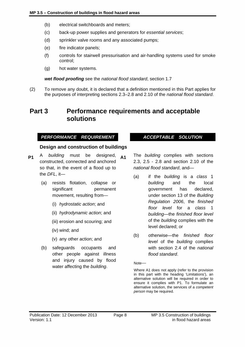
Part 3 Performance requirements and acceptable solutions
PERFORMANCE REQUIREMENT ACCEPTABLE SOLUTION
Design and construction of buildings
P1 A building must be designed, constructed, connected and anchored so that, in the event of a flood up to the DFL, it—
(a) resists flotation, collapse or significant permanent movement, resulting from—
(i) hydrostatic action; and
(ii) hydrodynamic action; and
(iii) erosion and scouring; and
(iv) wind; and
(v) any other action; and
(b) safeguards occupants and other people against illness and injury caused by flood water affecting the building.
A1 The building complies with sections 2.3, 2.5 - 2.8 and section 2.10 of the national flood standard, and—
(a) if the building is a class 1 building and the local government has declared, under section 13 of the Building Regulation 2006, the finished floor level for a class 1 building—the finished floor level of the building complies with the level declared; or
(b) otherwise—the finished floor level of the building complies with section 2.4 of the national flood standard.
Note—
Where A1 does not apply (refer to the provision in this part with the heading ‘Limitations’), an alternative solution will be required in order to ensure it complies with P1. To formulate an alternative solution, the services of a competent person may be required.

MP 3.5 – Construction of buildings in flood hazard areas
Publication Date: 12 December 2013 Page 9 MP 3.5 Construction of buildings Version: 1.1 in flood hazard areas
PERFORMANCE REQUIREMENT ACCEPTABLE SOLUTION
Design and location of utilities
P2 Utilities associated with a building, other than an electrical meter for a class 1 building, must be designed or located to reduce the effects of flood water on the utilities in the event of a flood up to the DFL.
A2 (1) Utilities associated with a class 1 building, other than an electrical meter for the building, are located above—
(a) if the local government has declared, under section 13 of the Building Regulation, the finished floor level for a class 1 building—the level declared; or
(b) otherwise—the flood hazard level.
(2) Utilities associated with a building other than a class 1 building are located above the flood hazard level.
Note— Electrical installations may be installed by a person only if the person is a licensed electrician. Electrical meters must be installed in accordance with electrical entity requirements.
Protection from backflow from sanitary drains
P3 A building with a sanitary drain must be protected from backflow so that in the event of a flood up to the DFL the effects of flood water on the building are reduced.
A3 (1) A building with a sanitary drain is protected from backflow by a reflux valve fitted between the building and—
(a) if the building has an onsite sewerage facility—the on-site sewerage facility; or
(b) otherwise—the connection point.
(2) Also, a reflux valve fitted under subsection (1) is accessible for maintenance in accordance with AS3500.2:2003, section 4.5.
Note—
A reflux valve may be fitted by a person only if the person is licensed to fit the valve under the Plumbing and Drainage Act 2002.

MP 3.5 – Construction of buildings in flood hazard areas
Publication Date: 12 December 2013 Page 10 MP 3.5 Construction of buildings Version: 1.1 in flood hazard areas
PERFORMANCE REQUIREMENT ACCEPTABLE SOLUTION
Design and location of customer dedicated substations
P4 A customer dedicated substation located in a building must be designed or located so its ability to function effectively is not affected by a flood event up to the DFL.
Note—
Under section 59(2)(a) of the Electricity Regulation 2006, an entity may require the owner of premises to provide space on the premises for a substation.
A4 A customer dedicated substation located in a building is located above the DFL.
Note— Some planning schemes may not permit development be to be carried out on land prone to flooding. Check with the local government in the area to determine what land use restrictions apply to the relevant lot.
Version history
Version Publication date Commencement date 1.0 22 October 2012 26 October 2012 1.1 12 December 2013 20 December 2013