rajasthan land revenue (survey/resurvey using modern...
TRANSCRIPT

1
Rajasthan Land Revenue (Survey using Modern Methods, Records & Land
Classification) (Government) Rules, 2018.
Preamble: -- This Survey-Resurvey is the largest exercise of its kind after more than 100 years
when all the land was originally surveyed and cadastral maps were prepared for the first time
in the state of Rajasthan. At that time, survey and settlement operations were basically carried
out for accurate assessment of the land revenue to be collected from the peasants.
However, the following major changes have occurred since then: --
1. Land has become more valuable than land revenue --- Since last 4-5 decades the value
of land per-se has gone up by orders of magnitude. Earlier, the value of land used to be
only about 10 times its annual rent or even less, whereas with the advent of
urbanisation, industrialisation and development, the value of land has now become
1000 to 100,00,000 times compared to the land revenue rates. Land revenue has
become almost insignificant as a source of income for the Government. In fact in many
states, including Rajasthan, collection of land revenue has been put on hold indefinitely.
2. Smaller size of land parcels --- Sizes of land parcels have been reduced considerably
with increase in population and division of land holdings and also due to land being put
to non-agricultural use.
3. Evolution of Technology --
a. Traditionally, survey operations were carried out using manual plane table
survey methodology whereby distances were measured using metal chains and
angles were measured using the right-angle instrument. This method was prone
to both systemic as well as random human errors besides the fact that possibility
of manipulation of measurements due to various pressures was omnipresent.
b. With the advent of newer technologies like Electronic Total Station, Global
Positioning System, Satellite Imagery and Internet etc, it has now become
technically and financially feasible to generate highly precise and accurate maps
with improved accuracies ranging from less than 1cm to 40 cm. Modern maps
are geo-referenced and have a lot more information than the traditional
cadastral maps.
4. Non-agricultural use of Land -- Use of land for purposes such as industrial, residential,
commercial and institutional etc. has become more pronounced with development, thus,
it has become important to keep track of these converted land parcels. Sizes of these
also tend to be much smaller than agricultural land parcels.
When the Land Revenue Act was enacted in 1956 and the Survey, Record and Settlement Rules
were made in 1957, the ground reality was quite different. These new rules attempt to enable
preparation of new cadastral maps and new record of rights which are precise, accurate and

2
high on integrity. They will serve as the foundation for a newly developing state and nation. As
described above, Settlement Operations have lost much of their relevance because their sole
purpose was determination of land rent, and thereby, land revenue. Soil classification has
gained new found relevance because DLC rates of land depend mainly upon soil classification.
Also, classification records the current usage of the parcel of land (e.g. Gair-mumkin-abadi,
Gair-mumkin jungle, Gair-mumkin-udyog etc.). At present the land use needs to be recorded
on the basis of the current use of land while conducting survey operations.
DILRMP is based on following three principles of modern land title systems followed the
world over:
1. Mirror Principle - Cadastral map and record of rights should mirror the ground reality
accurately and precisely
2. Curtain Principle - Once mirror principle is implemented, it becomes possible to
implement a curtain on land transactions - which means the current title is true and the
purchaser does not have to worry about past records and the chain of transactions
leading to the current situation.
3. Title Guarantee - Every land owner's title is guaranteed for its correctness and a title
holder is indemnified against any loss suffered due to any defect in the Title of the Land.
Survey Re-Survey being undertaken under DILRMP will assure compliance with the mirror
principle which can then be taken further towards Curtain Principle and Title Guarantee by
appropriate legislation.
Satellite Imagery brings a high level of integrity into the process - it allows for an ex-post-
facto checking of maps with the help of satellite image. This makes it possible for any person in
the hierarchy from the Settlement Commissioner down to the Jr. Surveyor to ensure the
accuracy of the prepared map by using DGPS-RTK instruments. It also enables common man
to measure his land himself and compare the prepared map with the satellite image. In fact,
once the cadastral layer is superimposed on the satellite imagery (e.g. in software like Google
Maps), much of this work can be done on a desktop computer.
Therefore, in exercise of the powers conferred by Sub-section 2 of Section 261 of the
Rajasthan Land Revenue Act, 1956 (Rajasthan Act No 15 of 1956), the State
Government hereby makes the following Rules, namely:-
1) Title – These Rules may be called the Rajasthan Land Revenue (Survey using
Modern Methods, Record & Land Classification) (Government) Rules, 2018.
2) Extent: - They extend to the entire State of Rajasthan.
3) Commencement: - They shall come into force on the date of their publication in the
official gazette.

3
4) Interpretation: In these rules, unless there is anything repugnant in the subject or
context –
(1) ‘The Act’ means the Rajasthan Land Revenue Act, 1956
(2) ‘Director’ means the Director of Land Records for Rajasthan. (whose powers are
to be exercised by Settlement Commissioner for the purpose of these rules)
(3) 'Additional Land Records Officer' means the Settlement Officer (SO)
(4) 'Assistant Land Records Officer' means the Assistant Settlement Officer (ASO)
(5) ‘Form’ means a form appended to these Rules.
(6) ‘Government Land’ – Land where khatedar is State/ Central Government or Local
Body/ Board/ Department of the State/ Central Government or any other
organisation wholly or partially owned by the State/ Central Government.
(7) ‘Ground Control Network’ (GCN) – A network plan consisting of permanent
reference points to be used for geo-referencing of cadastral maps as per detailed
technical specifications prescribed by the Director.
(8) ‘Ground Control Point’ (GCP) – Specific reference point to be setup as per
Ground Control Network on basis of detailed technical specifications prescribed
by the Director. (Survey marks as mentioned in Section 130 of the Act)
(9) ‘UTM’ - Universal Transverse Mercator Projection.
(10) ‘Survey’ means survey by modern technological methods and shall include
re-survey.
(11) ‘Section’ means section of the Act.
(12) ‘DGPS-PPK’ means Differential Global Positioning System - Post
Processing Kinematics.
(13) ‘DGPS-RTK’ means Differential Global Positioning System - Real Time
Kinematics.
(14) ‘ETS’ means Electronic Total Station.
(15) ‘ORI’ (Ortho Rectified Imagery) means Processed and Ortho-rectified
image obtained from High Resolution Satellite Imagery or by any other modern
methods as mentioned in these rules.
(16) ‘Temporary Khasra Number’ (TKN) - means provisional Khasra Number
assigned to polygons during the intermediate stage of preparation of Cadastral
Map.
Rules to give Effect to Section 109

4
5) Establishment of Ground Control Network – A ground control network consisting
of iconic, sub-iconic, primary, secondary, tertiary and auxiliary ground control points
will be established in the entire State of Rajasthan as per detailed technical
specifications notified by the Director.
6) All cadastral maps will be geo-referenced and prepared using a common projection
system which will be UTM for The State of Rajasthan.
7) Technology Options:-
(1) There are three technology options for Survey (as per technical details notified by
the Director):
(a) Ground Survey Methods using DGPS-PPK/ DGPS-RTK/ ETS system – In
these methods, every single parcel of land is to be surveyed using either
DGPS-PPK, DGPS-RTK or ETS systems.
(b) HRSI and ground-truthing system using DGPS-RTK/ DGPS-PPK/ ETS– In
this method, new cadastral maps are prepared using HRSI and then verified
for accuracy on the ground using DGPS-RTK/ DGPS-PPK/ ETS.
(c) Aerial Survey and ground-truthing using DGPS-RTK/ DGPS-PPK/ ETS – In
this method, new cadastral maps are prepared using images obtained by aerial
survey of the land surface and then verified for accuracy on the ground using
DGPS-RTK/ DGPS-PPK/ ETS.
(2) Survey will be carried out using any one or a combination of the 3 methods
specified in7) above as notified by the State Government for any particular area of
the State.
8) Units of measurement: All survey is to be carried out and recorded in the metric
system.
9) Scale of Maps: All maps are to be prepared on a scale of 1:4000 unless the
Additional Land Records Officer allows use of a different scale in cases where size
of the land parcels is too small to be seen properly on 1:4000 scale.
10) Unsurveyed Areas: If any unsurveyed area is found during survey operations, it
may be added to an adjacent village(s) or a separate revenue village be created as
decided by the Additional Land Records Officer.
11) Pre-Survey Activities: Following pre-survey activities must be completed before
Survey Resurvey work is started in a Tehsil
(1) Survey Re-survey work is to be carried out only in those tehsils which have been
notified as online under Rule 169–H of Rajasthan Land Record Rules 1957 and
where both Jamabandi and map are now online on eDharti and BhuNaksha web
portals and one-to-one mapping between Jamabandi and map has been completed.

5
(2) Tehsildar of concerned Tehsil shall issue a certificate for all villages of the Tehsil
to Asstt Land Records Officer in Form 10 after ensuring the following:
(a) Succession mutations are opened for all dead khatedars
(b) Mutations to execute all pending decrees/ orders of courts have been done
(c) All pending tarmeems have been done to the online village map
(d) All cases under Section 136 of the Act are either decided or transferred to the
court of Asstt Land Records Officer
(e) All cases under Section 48/ 49 of Rajasthan Tenancy Act 1955 are decided
and mutations done
Rule to give Effect to Section 110
12) Proclamation for Publicity of Survey and Record Writing -- Additional Land
Records Officer to issue proclamation in Form 1 under Section 110(1) and in Form
2, under Section 110(2) respectively to be published in at least one newspaper with
wide circulation in the area in Hindi language.
Rules to give Effect to Sections 111, 112, 113 and 114
13) Preparation of ORI –The image obtained from the technologies mentioned above
will be processed to obtain an Ortho Rectified Image (ORI).
14) Determination of the Village Boundary:
(1) The village boundary of the digitised version of old cadastral map (OCM) will be
superimposed onto the ORI.
(2) A traverse will be made on the village boundary with DGPS-RTK to locate
existing boundary pillars, take their co-ordinate readings, and take co-ordinate
readings of all tri-junctions and all significant physical features on the boundary.
(3) As far as possible, the village boundary shall be taken along the pre-existing
physical features. Small departures from the pre-existing boundary are acceptable
to align it with the pre-existing physical features.
(4) It should be kept in mind that determination of boundary is not done to benefit or
cause loss to any specific individual(s).
(5) The area thus calculated with the new village boundaries may differ from the
previously calculated village area.

6
(6) The Director may issue separate directions with regard to any other specific issues
that may arise in determination of the village boundary.
15) Preparation of Village Land Parcel Map (VLPM) and assigning of TKN-
Inside the area enclosed by village boundary, on the basis of the visible bunds and
physical features, lines will be drawn to create polygons and a separate TKN will be
assigned to each polygon.
16) Ground Truthing of Village Boundary, Village Level Parcel Map and
recording of possession, soil classification and source of irrigation -- Ground
Truthing will be done for village boundary and every polygon inside the village
boundary using DGPS-RTK. A Register in Form No. 3 will be prepared to record
possession, soil classification and source of irrigation (if any) for each polygon.
17) Preparation of Area Comparison analysis Sheet in Excel -- A khata wise and
khasra wise excel sheet in Form No. 5 will be prepared. Rows will be inserted to do
Khata-wise totals and ascertain area variations at the level of Khata. It will be then
sorted by Column 10 on Khata level area variation percentage in descending order.
18) Preparation of new village map and record of rights –
(1) Old Cadastral Map will be super imposed on Village Land Parcel Map. The Super
imposition will enable generation of Parcel 1, 2 & 3 lines as mentioned below-
(a) Parcel 1 -- Solid Lines – All those lines which exist on old cadastral map and
more-or-less coincide with the existing field boundaries as seen on the ORI.
(b) Parcel 2 -- Chain Lines (dash-dot-dash lines _._._._. ) – All those lines which
need to be shown on the map for the purpose of honouring legal ownership
boundaries, but no physical feature exists along that line.
(c) Parcel 3 -- Dash lines (--------) – All lines which are not part of any khasra but
which represent significant permanent features on the field such as – field
boundaries/ fencing/ boundary walls/ dams/ anicuts/ bunds/ ditches/ line of
trees/ canals/ pathways/ gas or water pipelines etc.
(2) Information compiled in Form No 3 will be compared with the above
superimposed map and read along with existing Jamabandi to decide the final map
and record of rights. Mirror Principle must be followed while doing this exercise
as per the following:
(a) In the case where a khasra or a group of khasras of another village are situated
inside the boundary of the village in question, then such island khasras shall
be merged with the village in question.
(b) In case of a trespass on Government Land it should be marked out with a
hatching and not be included in individual khatedar’s land.

7
(c) In case of trespass on private land, it should be marked as a separate khasra
number and assigned to the title holder khatedar.
(d) If any shifting of pathways is involved which is actually used by people then it
should be allowed, if it does not amount to significant gain or loss in area(s) to
the individual(s).
(e) Variation in the area of an individual khasra number should be ignored if the
total area of the khata is more or less the same.
(f) If variation in the area of khasra causes significant variation in the area of a
khata, then, it should be verified whether any trespass has been made on
neighbouring Government land or khatedar’s land. If no such trespass is
observed, the land as per individual’s possession should be recorded in his
khata.
(g) If any khatedar who was allotted land in a particular khasra number in OCM is
in possession of a different parcel of land, land currently under his possession
shall be recorded in his name to the extent of area allotted to him.
(h) If two khatedars have informally exchanged lands, it shall be regularised by
the Asstt Land Records Officer as per provisions of Section 48 of Rajasthan
Tenancy Act 1955.
(i) If it is observed that Patwari had made any error while updating (tarmeem) the
OCM, then new record will be prepared as per ground reality.
(j) If any clerical errors are observed in the old record of rights or old map while
doing this exercise either suo-moto or on application of a khatedar they will be
corrected by Asstt Land Records Officer under Section 136 of the Act.
(3) Permanent Khasra Numbers will then be assigned to each polygon on the newly
created map starting with number 1 from North-West corner of the village.
19) Consultation will be made with every individual khatedar as required for removal
of discrepancies noticed during analysis of Form 3 and Form 5 before parcha notice
is issued.
20) Registers to record Trespass under Section 114(d) –
(1) Register of Government Lands under Trespass will prepared in format specified in
Form No 8 along with a map showing all such lands in hatching of this type –
(/////)
(2) Register of Private Lands under Trespass will be prepared in format specified in
Form No 9 along with a map showing all such lands in hatching of this type –
(\\\\\)
21) Mapping Register (Milaan-Kshetrafal) -- between new and old map and record
of rights will be prepared in Form No 11.

8
Rules to Give Effect to Sections 115, 116 and 117
22) Procedure Regarding Unsurveyed lands, abandoned lands and lands being
used for public purposes -- Analysis of contents of Form No 3 and Form No 5 will
reveal following types of land which is covered under Section 115 of the Act:
(1) Previously unsurveyed land – Any land which was previously unsurveyed will
have no owner as per existing Jamabandi
(2) Abandoned land – Land whose owner as per existing Jamabandi is dead or not
traceable and no legal heirs are traceable. This land could either be lying fallow or
possibly be cultivated / used by another person who has no legal title over the
land.
(3) Land being used for public purposes – Land which is owned by a khatedar as per
OCM and Jamabandi but is being used for a common/ public purpose like school,
anganbadi, road, canal, water tank or any other such public purpose
23) A proclamation listing all such lands in Form No 4 will be issued through
publication in Daily Hindi Newspaper with wide circulation in the area and also by
displaying in the office of Gram Panchayat, Tehsil and ASO offices. It will also be
displayed on specified web portal along with a map of the village where each of the
land parcels included in proclamation is specifically marked.
24) Claims can be filed electronically on specified web portal and will be decided by
Asstt Land Records Officer as per Sections 115, 116 and 117 of the Act where
procedure in 115 will be followed for abandoned lands, in 116 for previously
unsurveyed lands and in 117 for land being used for public purposes respectively.
Rule to give Effect to Section 119
25) Determination of Abadi of a Village –
(1) Abadi refers to a cluster of houses or land used for common purposes like waste
disposal, water supply, parks or any other ancillary purpose
(2) Any land irrespective of its soil classification and ownership which is being used
for the purpose of abadi as per ORI (as verified during ground truthing) of the
village will be recorded as abadi land.
(3) Assistant Land Records Officer will ascertain if any additional abadi land is
needed as per norms specified by Government and record such land as abadi from
Government land in the village.

9
(4) If the above exercise leads to reduction in area for pasture land so that it falls
below specified norms, it may be compensated by declaring additional
government land as pasture either in same village or neighbouring villages.
Rules to Give Effect to Sections 121 and 122
26) Service of Parcha Notice:
(1) Parcha notice will be served to all tenants of every khata in Form No 6 by any
electronic method as notified by the Director or in the manner specified in Section
60 of the Act.
(2) Delivery of parcha notice shall be presumed to be attestation of entry if no
objection to the contrary is received from any party within the specified time.
27) Hearing of Objections:
(1) Objections, if any, will be filed electronically through web portal designated for
this purpose.
(2) They will be heard at the pre-specified date, time and venue (which will preferably
be in a Government building situated in the village) a minimum of 30 days after
delivery of the notice.
(3) Objections filed against the details contained in the above parcha notice by
interested parties will be decided as per Section 122 of the Act.
(4) Parcha Khatauni (or Misal bandobast) and a Map will be prepared in Form No 7.
(5) On the date specified, every entry in the Parcha Khatauni shall be read out to all
the persons present. If any objections are received from anyone present, they shall
be decided in accordance with Section 122 or other relevant provisions of the Act.
28) All maps, field-books and other registers prepared by the Land Records Officer
may be seen or downloaded for printing by the interested parties free of cost on
specified online website.
29) A physical/ hard copy of these records shall also be displayed on the notice board
of the concerned Gram Panchayat Office/ Patwar Ghar for 15 days before they are
considered final and legally promulgated.
30) Promulgation of Map, Field Book & Record of Rights:
(1) Before the final copy for promulgation of map, field book and record of rights is
prepared – old record of rights and the old online cadastral map will be locked by
Asstt Land Records Officer on eDharti and bhuNaksha web portals and their final
version downloaded.

10
(2) It must be ensured that any changes that have taken place in the online version
while the survey-resurvey activity was taking place are incorporated into the
version being prepared for promulgation.
(3) For promulgation of the map, field book and record of rights, soft copy of these
will be electronically signed by the concerned Jr Surveyor, Sr Surveyor and Asstt
Land Records Officer and then presented to Additional Land Records Officer. It
will be considered legally valid upon approval by the Additional Land Records
Officer.
(4) A paper copy of the same will also be prepared, signed and approved as in (1)
above which will kept as record in the office of Additional Land Records Officer.
(5) New promulgated map and record of rights will be made available to concerned
Tehsildar through uploading to specified web portal on same day on approval of
Additional Land Records Officer.
Rule to Give Effect to Section 126
31) Existing online map on bhuNaksha web portal and record of rights on eDharti
web portal will continue to be updated by Tehsildar as per provisions of Rajasthan
Land Record Rules 1957 while the survey-resurvey operation is on.
Rule to Give Effect to Section 150
32) Soil Classification will be done in Form 3 as per ground reality on the basis of the
following chart:
S.No. Soil Class Details
1 चाही Irrigated by well / tube-well
2 नहरी Irrigated by canal
3 तालाबी Irrigated by tanks / ponds
4 दीगर स िंसचत Irrigated by other sources
5 बारानी Rain Fed

11
6 बिंजड Fallow Land
7 ग़ैर मुमकिन Non-Agricultural Uses to be listed as
ग़ैर मुमकिन - Use
a आबादी Residential Use
b िुआँ Well or Tube-well
c नहर Irrigation canal
d नदी River
e नाला Rivulet / Nallah
f जिंगल Forest
g औद्योसगि Industrial Use
h वाणिणयिि Commercial Use
i िंस्था Institutional Use
j ऩहाड़ Hill / Mountain
k शमशान Cremation Ground
l क़ब्रिस्तान Burial Ground
m मिंकदर Temple
n मणस्जद Mosque
o तालाब Pond
p आगौर Catchment Area

12
q चरागाह Pasture Land
r औरि Forest / Pasture associated with a
Temple
8 ग़ैर मुमकिन अनासधिृत - Use
To be used for lands which have been
used for non-agricultural usage without
proper autorisation as per law – e.g. for
illegal residential colonies, soil
classification will be
ग़ैर मुमकिन-अनासधिृत आबादी
33) Repeal & Savings: -
(1) All actions with respect to survey-resurvey using modern technological methods
by Director and all subordinate officers since issue of notification under Section
106 for survey-resurvey under the Digital India Land Records Modernisation
Programme (DILRMP) shall be presumed to have been done under these rules.
(2) Rajasthan Land Revenue (Survey, Record & Settlement) (Government) Rules
1957 will be presumed to have been repealed with immediate effect except in
cases where survey/ resurvey operations have already been started under these
rules and are still pending completion. In such cases they would be presumed to
continue until those operations come to a close.
(3) Director may issue notifications, directions and clarifications with regard to
operation of these rules either specifically with regard to any rule or generally with
regard to the survey re-survey operation.

13
Chart of various forms and what they are to be used for:
Form
Number
Section of
Act
Rule Description Authority
1 110(1) 12) Proclamation Ad LRO
2 110(2) 12) Proclamation Ad LRO
3 112 16) Ground Truthing Register Ast LRO
4 115 23) Proclamation under Section 115 Ast LRO
5 112 17) Excel Sheet Ast LRO
6 122 26) Parcha Notice Ast LRO
7 121 27) Khatauni (Misal-Bandobast) Ad LRO
8 114(d) 20) Register of Government lands under
trespass
Ast LRO
9 114(d) 20) Register of khatedari lands under
trespass
Ast LRO
10 109 11)(2) Certification of completion of Pre-
Survey Activities
Tehsildar
11 114(d) 21) Milan Kshetrafal Ast LRO

14
Form No. 1
Proclamation under sub-sec. (1) of Sec. 110 of
The Rajasthan Land Revenue Act, 1956
(See Rule 12)
Whereas by a notification issued by the State Government under Sec. 106 of the
Rajasthan Land Revenue Act, 1956 (Act No. t5 of 1956) the area specified on the
margin has been placed under survey and record operations, all estate-holders and
tenants of the aforesaid area are hereby informed that they are bound to render such
assistance as may be required of them by the undersigned or any other person deputed
by him in the survey of the boundaries of the village as well as the boundaries of the
fields therein.
Given under my hand and seal this ……. Day ……. Of ……. 20…….. (area to be
specified)
Additional Land Records Officer

15

16
Form No. 2
Proclamation under sub-sec. (2) of Sec. 110 of
The Rajasthan Land Revenue Act, 1956 (15 of 1956)
(See Rule 12)
Whereas by my proclamation dated …….. all estate-holders and tenants of the area
specified on the *margin were informed of the liability to render assistance in the survey
of the boundaries of the villages as well as the boundaries of the fields therein, this
proclamation is now being issued under sub-sec. (2) of Sec. 110 of the Rajasthan Land
Revenue Act, 1956 (Act No. 15 of 1956) and the estate-holders and tenants are hereby
directed to erect within 15 days of the proclamation, the under mentioned boundary
marks to define the limits of their villages, estates or fields.
Take notice that in default of compliance within the
time specified in this proclamation, the Additional Land Records Officer will himself
cause such boundary marks to be erected at their cost, which will be recovered as an
arrear of land revenue.
Given under my hand and seal this ……………………. Day of ……..
20………(particulars of boundary-marks to be given).
Additional Land Records Officer
___________________________
*Area to be specified.

17
Form No. 3
Ground Truthing Register
(See Rule 16)
Village Code… Name of Village... Patwar Circle…. ILR Circle… Tehsil…..
District…..
TKN
NO.
Old
Khata
No.
Name of
person in
Possession
Khatedar
/Co-
tenant
Trespass
reported,
if any
Soil
Classification
TKN of
Source of
Irrigation
Public
utility,
if any
Remarks

18
Form No 4
Proclamation under Section 115 of
The Rajasthan Land Revenue Act, 1956(Act No. 15 of 1956)
(See Rule 23)
Whereas lists of lands situated in the under-mentioned village which appear to have no
lawful owner have been prepared, this proclamation is being issued under Section 115
of The Rajasthan Land Revenue Act, 1956 to inform all concerned that if anyone has
any claims to or over any for the Lands specified in the appended list, he may present
his claim and the grounds there for by means of a petition in writing within 3 months
from the date of the proclamation.
Take notice that if no such claim is preferred within the prescribed period, the lands
mentioned in the appended list will be declared to be the property of the State and
demarcated as such.
(Given under my hand and seal this…………. Day of……….. 20....
Additional Land Records Officer
Details of unclaimed lands situated in the Village……… Patwar Circle……. ILR
Circle…….. Tehsil…… District…..
Temporary
Khasra No.
Old
Khasra
No
Old
Khata
No
(if
any)
Area Description and
purpose for which land
appears to be used
Name of the person
in possession, if
any.

19

20
Form No.5
Excel Sheet
(See Rule 17)
Village Code … Name of Village... Patwar Circle…. ILR Circle… Tehsil…..
District…..
Column Number Title of Column Remarks
1 Old Khata Number Taken from existing
Jamabandi
2 Old Khasra Number All Khasras which are
part of this khata to be
mentioned here
3 Area as per RoR (in
hectares)
From Old Jamabandi
4 Area as per Old
Cadastral Map (in
hectares)
Auto-calculated area
from existing digitized
cadastral map
5 TKN of Khasra which is
in possession of
Khatedar and is closest
in shape to old khasra
number.
6 Area of TKN in column
5 (in hectares)
Auto-calculated
7 Area difference between
new khasra and RoR
Col 6 – Col 3
8 Area difference between
new khasra and khasra in
Col 6 – Col 4

21
old cadastral map
9 Percentage difference
between new khasra and
RoR
(Col 7/ Col 3) * 100%
10 Absolute value of
Percentage difference
|Col 9|
11 Names of Khatedars as
per RoR
12 Reasons for differences
in Area as per
preliminary discussion
with Patwari & Amin
13 Reasons for differences
& suggestions for
solutions on basis of
ground truthing

22
Form No 6
(See Rule 26)
Government of Rajasthan
Settlement Department, Rajasthan
Parcha Notice
Parcha No. Date of Issue:
Village Name: Village Code: Patwar Circle: ILR Circle:
Tehsil: District: Year:
Name of Landholder - Rajasthan Government
Name of Khatedar 1 …………………………………
2…………………………………..
3…………………………………..
4…………………………………..
Details in Last RoR Details after Survey
Khasra
No &
Name of
Land
Area
(Hectare/
Bigha)
Source
of
Irrigati
on
Soil
Clas
sific
atio
n
Rent
(Rs) Remarks
Ne
w
Kha
sra
No.
Area
(Hect
are)
Perim
eter
(Mete
rs)
Source
of
Irrigati
on
Soil
Clas
sific
atio
n
Re
nt
(Rs
)
Remarks
1 2 3 4 5 6 7 8 9 10 11 12 13

23
Village Name: Tehsil: District: Notice No.
Note:
1. Please ensure that you are satisfied with the particulars of your land given above as per
the new survey. You can verify the measurements given that they are as per your
possession.
2. If you notice any errors in the above details or you have any other issue an objection in
writing can be filed online at any E-Mitra centre OR at the office address given below
before Date……………….. Hearing on the Objection will be on Date……….
Place………… In case of no objection is received, it will be presumed that you have
accepted and attested the entry of your land ownership as given above.
Jr. Surveyor Sr. Surveyor Asstt Land Records Officer cum ASO
Name: Name: Name:
Signature Signature Signature:
Date Date Date:
Mobile No: Mobile No: Mobile No:
Address of Office of Asstt Land Records Officer cum Asstt Settlement Officer:
Total
Draft L.P.M.
24
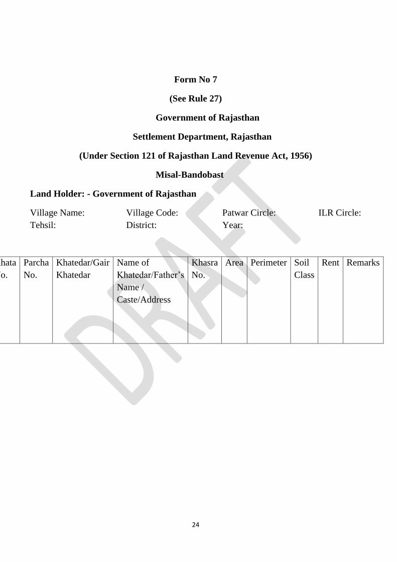
Form No 7
(See Rule 27)
Government of Rajasthan
Settlement Department, Rajasthan
(Under Section 121 of Rajasthan Land Revenue Act, 1956)
Misal-Bandobast
Land Holder: - Government of Rajasthan
Village Name: Village Code: Patwar Circle: ILR Circle:
Tehsil: District: Year:
Khata
No.
Parcha
No.
Khatedar/Gair
Khatedar
Name of
Khatedar/Father’s
Name /
Caste/Address
Khasra
No.
Area Perimeter
Soil
Class
Rent Remarks

25
Form No. 8
Register showing trespass on Government Land
(See Rule 20)
Village Code… Name of Village... Patwar Circle…. ILR Circle… Tehsil…..
District…..
Khata
Number
Name of
Khatedar
Khasra
Number
Soil
Classification
Total
Area of
Khasra
Area
under
Trespass
Name &
Mobile
No of
Trespasser
Khata
Number
of
Trespasser
(if any)
Use
land
has
been
put to

26
Form No. 9
Register showing trespass on Khatedari Land
(See Rule 20)
Village Code… Name of Village... Patwar Circle…. ILR Circle… Tehsil…..
District…..
Khata
Number
Name of
Khatedar
Khasra
Number
Soil
Classification
Area
of
Khasra
Name &
Mobile
No of
Trespasser
Khata
Number
of
Trespasser
Use
land
has
been
put
to
Remarks

27
Form No 10
Pre-Survey Activity Completion Certificate by Tehsildar
(See Rule 11)
S No Activity Initials of Patwari Initials of ILR
1 Virasat mutations of all dead
khatedars have been opened and
decided.
2 All pending tarmeems have been
done on bhuNaksha
3 All mutations to execute court
orders / decrees have been
opened and decided
4 All pending cases under S 48,
RTA have been decided and
mutations done
5 All pending cases under S 136
LR Act have been decided and
mutations done
It is hereby certified that Pre-Survey activities for Village_______, Census
Code________, Patwar Circle_______, ILR Circle________, Tehsil_______,
District_______ as listed above have been completed.
Name: _______________
Designation:________________
Date: __________

28
Form No 11
Milan Kshetrafal
(See Rule 21)
Village_______, Census Code________, Patwar Circle_______, ILR
Circle________, Tehsil_______, District_______
(New from Old One-Many Map with Area)
New Khasra
Number
Area of new khasra
(in hectares)
Old Khasra
Number
Area of Old Khasra
included in new
Khasra (in hectares)
(Old to New One-Many Map)
Old Khasra Number New Khasra Numbers which have formed
out of the Old Khasra