rainfall-induced slope failures: mechanism …civil.eng.usm.my/rezaur/publications/conference...
TRANSCRIPT
Keynote Lecture: International Conference on "Management of the Land and Water Resource" −MLWR, 20−22 October 2001, Hanoi, Vietnam. 281-291
281
1 INTRODUCTION
Shallow landslides are very frequent in Singapore par-ticularly as urban development has increased greatly since the 1970s (Toll et al., 1999). The major factor af-fecting landslides is the tropical rainfall events (Rahardjo et al., 2000). A summary of landslides in Singapore re-ported in literature are summarized in Table 1, in terms of year of occurrence, landslide type, slope angle, height, ground condition and the extent of materials involved. Although slope failures in Singapore are not comparable in scale to those in other Southeast Asian countries and no fatal incident has been reported, they nevertheless are of appreciable significance. Previous studies on slope failures (Tan et al., 1987; Lo et al., 1988; Toll et al., 1999) indicate that rainfall has been the triggering factor for slope failures in Singapore. These slope failures can be hazardous, disruptive to the development of infrastruc-ture and costly to repair. Therefore, it is appropriate that a better technology for preventing these failures be devel-
oped. This appropriate technology can be developed only if the mechanisms of rainfall-induced slope failures are properly understood with special consideration to the lo-cal climate and geology.
The main objectives of this study were to determine the mechanism that leads to rainfall-induced slope fail-ures in residual soils, to develop guidelines for stability assessment against such failures with special considera-tion to local climate and geology and to evaluate several possible preventive measures.
2 MATERIALS AND METHODS
2.1 Study area
Four slopes were selected for the study. Two of the slopes were located in the residual soils of the granitic Bukit Timah formation (Mandai and Yishun); and the other two slopes were located in the residual soils of the
RAINFALL-INDUCED SLOPE FAILURES: MECHANISM AND ASSESSMENT
H. Rahardjo, E.C. Leong & R.B. Rezaur NTU-PWD Geotechnical Research Centre.
School of Civil and Structural Engineering, Nanyang Technological University, Singapore
ABSTRACT: Two-thirds of Singapore’s land area is covered with residual soils from the sedimen-tary Jurong and the granitic Bukit Timah formations. Rainfall-induced slope failures often occur in these residual soils as a result of tropical rainfall events. These slope failures can be dangerous, dis-ruptive to infrastructure development and costly to repair. An appropriate design philosophy can be adopted if the mechanism of rainfall-induced slope failures is understood. Four research slopes were selected to study the mechanism of rainfall induced slope failures. These slopes were in the sedimentary Jurong and the granitic Bukit Timah formations in Singapore. The research slopes were instrumented to provide real-time measurements of pore-water pressure, soil temperature, groundwater table, and rainfall events on the slopes. The field monitoring results were analyzed to determine the magnitude and distribution of pore-water pressures under various climatic condi-tions, the influence of antecedent rainfall and the mechanism of water flow at the research slopes. Slope stability analyses were conducted for the best and worst pore-water pressure distributions re-corded in each slope to determine the factor of safety for the slopes. Results indicate that, initially, downward infiltration of rainwater can cause the development of a perched water table in the zone of about 3 m below the slope surface. Subsequent water flow through the perched water table was mainly in the downslope direction. A parametric study was performed to model the infiltration of rainwater into the residual soil slopes and its effects on the stability of the slopes. Charts for as-sessment of stability of slopes during rainfall were developed. The parametric study revealed that slope angle and pore water-pressure distributions are important factors when assessing slope stabil-ity. The height of the slope is not a significant factor. Preventive measures and construction proce-dures can be undertaken to reduce the risk of rainfall-induced slope failures. One such method is to use engineered soil covers to limit rainwater infiltration during wet periods while allowing evapo-ration during dry periods.

282
sedimentary Jurong formation (NTU-CSE and NTU-ANX). The locations of the four selected slopes with reference to major geological formations of Singa-pore are shown in Figure 1. Climates at the study sites are hot and humid equatorial type, with no marked dry sea-son. The temperature varies little throughout the year with an annual average of 26.6°C. The mean relative hu-midity is 84% and the average potential evaporation is 2000 mm. The average annual rainfall is 2300 mm (Me-teorological Service Singapore, 1997). The rainfall is usually greatest in the months of November to January but rain falls in all months of the year. An average of 179 rainy days occurs in a year and rainstorms are short, in-tense and generally have a limited spatial extent (Toll et al., 1999). The vegetation in the research slopes is dense grass.
2.2 Field instrumentation and data collection
During the site selection, topographic survey was con-ducted to establish the geometry of the research sites. Ground investigations were performed to establish the stratigraphy of the sites and to collect undisturbed soil samples for laboratory testing to determine index proper-ties, engineering properties and mineralogy of the soils at the study sites. The ground investigation consisted of drilling boreholes, collection of undisturbed soil samples and installation of piezometer casing. A total of 19 bore-holes were drilled in the four sites: Yishun (6), Man-dai (6), NTU-CSE (5) and NTU-ANX (2).
Each research slope was instrumented with tensiome-ters, piezometers, temperature sensors and a rain gauge. A network of 30 jet-fill tensiometers (6 rows × 5 col-umns) was installed in each slope. Each row (designated as row A to F) was designed to measure pore-water pres-sures at depths of about 0.5, 1, 1.5, 2.5 and 3 m (desig-nated as columns 1 to 5) below the ground surface and
Table 1. Location, year of occurrence, extent and ground con-dition of landslides in Singapore (adapted from Toll et al., 1999)
Location Year Slope angle,height
Ground condition Extent
Tanjong Gul 1972 Bench cut,30°, 25 m
Volcanic agglomerate,shale and residual soils
Affected 60 m of slope length,a vertical backscar of about2 m was formed and bulgingtook place at the toe
HillviewEstate
1982 13.5°, 22 m Residual soils derivedfrom Gombak Noriteand colluvium withKallang formation
Involved 50000 m3 of materialand destroyed five luxuryresidential houses. (heavyrainfall)
Depot Road 1984 Bench cut,29°, 40 m
Fill material Resulted in disaggregation ofthe fill material which thendeveloped into a debris flow.(heavy rainfall)
Fort Canning 1984 34°, 40 m Residual soils(Grade VI) formedfrom the sedimentaryJurong formation
Shallow failure surface ofabout 3 m below the groundsurface and 1500 m2 of theslope started to move. (trigger,heavy rainfall)
GillmanHeights
1985 Cut slope,34°, 17 m
Medium dense to denseresidual soil (Grade IVand V) derrived fromsedimentary rocks ofthe Jurong Formation
Showed signs of instability andwas stabilised using soil nails
Lorong Terigu 1988 Cut slope,27°, 24 m
Loose to medium denseclayey silt near thesurface, becoming verydense below 25 mdepth
The slip surface was 5 to 6 mbelow the ground surface at itsdeepest point
CentralBusinessDistrict
- 53°, 18 m Weathered sandstonesand shales of theJurong formation
A number of failures occurredduring the construction of asubstantial excavation site.(heavy rainfall)
AdmiraltyRoad
1987 Cut slope Fill material ofweathered graniteoverlying deeplyweathered in-situgranite
Failed in five places, two ofwhich involved the wholelength of the slope. (heavyrainfall)
Bukit Batok 1989 Cut slope,27°, 40 m
Highly weathered rockof the Gombak Noriteformation. The residualsoils of highlydecomposed graniteconsisted of clayey siltwith boulders
Slide was 56 m from toe tocrest and the maximum depthof failure surface was 8.5 m. Aback scar of 4 to 6 m wasformed and about 100 m of theslope was affected. (heavyrainfall)
NTU Campus 1950to
1995
108 minorlandslides.Cut slope,30º to 39º &50º to 54º
Terraced slopes cut forlandscaping, residualsoils of the sedimentaryJurong formation
Majority involved volumes ofsoils less than 100 m3. Onlytwo slides were more than400 m3. Most of the slideswere of rotational type, onlysmaller numbers demonstratedtranslational slip or slumpmovements (heavy rainfall)
Fig. 1. Locations of the four selected research slopes with ref-erence to the major geological formations of Singapore
Fig. 1. Locations of the four selected research slopes with reference to the major geological formations of Singa-pore
Fig. 2. Instrumentation layout for the Yishun slope

283
spaced about 0.5 m apart. The spacing between consecu-tive rows was 3 to 4 m and each tensiometer was fitted with a pressure transducer for automatic data collection. In addition to the tensiometers there were piezometers (about six in each slope) and temperature sensors in-stalled at various locations in each slope. Rainfall was re-corded on each slope with a tipping-bucket rain gauge.
Figure 2 shows the instrument layout (typical) for the Yishun slope.
All sensors within each slope were monitored auto-matically by a data acquisition system (DAS), specially designed to meet the need for this study and to withstand
the harsh field environment. The DAS was programmed to scan the sensors at four-hour intervals during period of no rain and at 10 minute intervals during rainfall and con-tinue at the same rate till 30 minutes after cessation of a rainfall event. A rainfall event would trigger the rain gauge. The power supply for the DAS and the sensors for each site were provided from solar panels and photo-
voltaic batteries. All components of the DAS were placed in a steel box. The DAS and the batteries were installed on site in a concrete enclosure to protect them from ad-verse weather effects while the solar panel was mounted
Fig. 3. Soil profiles of the instrumented slopes

284
on top of the concrete enclosure. Data were downloaded from the DAS every four-week.
3 RESULTS AND DISCUSSION
3.1 Ground investigations and laboratory test results
The results of ground investigation, index properties and mineralogical tests were combined to determine the soil profiles at the research slopes. Yishun and NTU-CSE slopes were characterized with three soil layers while Mandai and NTU-ANX slopes were characterized with four and two soil layers, respectively. Simplified soil pro-files of the research slopes are shown in Figures 3(a) to 3(d).
Laboratory tests for obtaining the saturated and un-saturated shear strength parameters were performed on the residual soil specimens from the Bukit Timah granitic and the sedimentary Jurong formations. The specimens tested for the Bukit Timah granitic soil originated from the Yishun slope (mid slope location, depth 2.5 to 4.0 m) while for the sedimentary Jurong formation the soil specimens were from the NTU-CSE slope (mid slope lo-cation, depth 4.0 to 5.0 m). The average effective angle of internal friction determined for the granitic Bukit Ti-mah and the sedimentary Jurong formations was 32° and 51°, respectively. The relatively higher effective internal angle of friction, φ′, for the sedimentary Jurong formation can be attributed to the high total density and cementa-tion of the specimen tested.
Summaries of the soil properties for each soil layer of the NTU-ANX and Yishun slopes are presented in Ta-bles II and III to reflect the general soil properties for the residual soils from the Bukit Timah and the Jurong for-mations.
3.2 Field monitoring results
The field monitoring data and analyses are too numerous to be included here. Only the salient features and sum-mary are reported here. The details and key findings can be found in a monograph (Rahardjo, et. al., 2000). Time series record of pore-water pressure at the study slopes showed that significant negative pore-water pressures can develop during prolonged dry periods. A typical short du-ration time series of rainfall and pore-water pressures at various depths near the crest (row B) of the Yishun slope is shown in Figure 4. The impact of rainfall on the slope’s soil-water condition is reflected in the pore-water pressure changes shown in Figure 4. Negative pore-water pressure developments during dry period and successive development of positive pore-water pressure at various depths in response to evaporation and rainfall are obvious from Figure 4.
Table 3. Summary of soil properties for the NTU-ANX slope
Layer No./ USCS Test No. of AverageDescription classification (units) tests value
1 CL-ML w (%) 4 22Silty CLAY LL 4 45* hard PL 4 26* moderate plasticity PI 4 19
fines (%) 4 58ρtotal (Mg/m3) 2 2.02
c' (kPa) 2 7φ' 2 31Gs 0 n/aCc 0 n/a
2 ML-CL w (%) 2 16Clayey SILT LL 2 46with siltstone and PL 2 29sandstone fragments PI 2 18
fines (%) 2 32ρtotal (Mg/m3) 0 n/a
c' (kPa) 0 n/aφ' 0 n/aGs 0 n/aCc 0 n/a
Table 2. Summary of soil properties for the Yishun slope
Layer No./ USCS Test No. of Average Max.Description classification (units) tests value value
1 ML w (%) 9 35 40SILT LL 9 45 53* moderate to PL 9 31 39 low plasticity PI 9 14 31
fines (%) 9 58 69ρtotal (Mg/m3) 7 1.88 1.96
c' (kPa) 1 12 12φ' 1 33 33Gs 3 2.688 2.700Cc 1 0.30 0.30
2 MH w (%) 7 52 58SILT LL 7 57 76* moderate PL 7 40 48 plasticity PI 7 17 28
fines (%) 7 78 87ρtotal (Mg/m3) 7 1.76 1.89
c' (kPa) 2 13 19φ' 2 29 29Gs 1 2.714 2.714Cc 1 0.64 0.64
3 SM w (%) 5 19 20Silty or Clayey LL 5 42 57SAND PL 5 26 34* fines with PI 5 17 23 moderate plasticity fines (%) 5 34 37* partially weathered ρtotal (Mg/m3) 3 2.05 2.11
c' (kPa) 2 35 50φ' 2 31 32Gs 3 2.667 2.672Cc 0 n/a n/a

285
Analyses of the time series of pore-water pressures
from the four slopes were made to evaluate the worst pore-water pressure conditions in the slopes. The worst pore-water pressure conditions were judged to be the pore-water pressure distribution with the highest magni-tude of positive pore-water pressures. The worst pore-water pressure condition that developed in the upper 3 m of the slopes consisted of positive pressures greater than zero at all depths monitored. Only NTU-ANX showed maximum positive pressure of zero for all depths.
The positive pore-water pressures however, did not exceed the hypothetical hydrostatic pore-water pressure
distribution with the fictitious ground water table located at the slope surface (i.e., a fully saturated slope) for any of the slopes. Figure 5 shows a plot of pore-water pres-sures at various depths at the crest of Yishun slope (row B) during different periods. The successive dissipation of negative pore-water pressures and generation of positive pore-water pressures at all depths in response to the rain-fall events shown in Figure 4 are clearly evident. Piezo-metric levels before and after the wet periods (see Fig-ure 4) are also shown in Figure 5 to reflect the groundwater table fluctuations.
3.3 Mechanism of rain water flow
The mechanism of infiltration into the residual soil slopes and the effect of climatic conditions (rainfall and evapo-ration) on the pore-water pressure distributions were of particular interest to this study. From the time series of pore-water pressures at all measurement locations, con-tour plots of pore-water pressure distribution and total hydraulic head distributions across the entire slope pro-file for key periods were prepared for each slope. Key pe-
Fig. 4. Time series of pore-water pressures at various depths at slope crest (row B) in Yishun slope
Fig. 5. Pore-water pressure distributions at various depths near the crest (row B) in Yishun slope during different time periods.
(a) Pore-water pressure (kPa)
(b) Total hydraulic head (m)
Fig. 6. Contour plots of pore-water pressure and total hydraulic head distributions in Yishun slope on 4 December 1998. (at the end of a dry period shown in Figure 4)

286
riods were taken to be: (i) the end of a prolonged dry pe-riod when pore-water pressures are at a minimum (i.e., slope stability is at a maximum), (ii) following one or a series of significant rainfall events when pore-water pres-sures are at a maximum (i.e., slope stability is at a mini-mum), and (iii) during a significant rainfall event when the pore-water pressure distribution was in transition. These contour plots provided useful information on the magnitude and distribution of pore-water pressures in the slopes during the key periods. The contour plots of pore-water pressure and total hydraulic head distribution for a typical slope (Yishun) during two key periods (dry and wet) are shown in Figures 6 and 7.
Figure 6(a) shows the existence of matric suctions
prevailing across the entire slope profile during a dry pe-riod (before the occurrence of rainfall events shown in Figure 4). The slope crest however experiences more suc-tion development than the toe. The contour plot of total hydraulic head distribution for this period, shown in Fig-ure 6(b) shows the existence of a hydraulic head gradient between the slope crest and toe, even under a dry condi-tion. As water flow is caused by a hydraulic head gradi-ent, this leads to a downslope migration of water. It is hypothesized that the upslope areas, in addition to drain-
ing vertically downwards also contribute to the downslope areas by lateral flows resulting in more drain-age upslope and more water retention downslope and thus the lower slope portion remains wetter than the up-slope areas. During dry periods in addition to vertical and lateral downslope drainage, combined influence of soil properties, climate, and vegetation encourage high matric suction development in the upslope areas than the adja-cent downslope areas. This leads to the variability of pore-water pressure distribution between slope crest and toe as observed in Figure 6(a).
Figure 7(a) shows widespread development of posi-tive pore-water pressure across the slope profile after a series of rainfall events (rainfall events shown in Fig-ure 4). Negative pore-water pressure of lower magnitude may still exist near the slope crest. A comparison of the total hydraulic head gradient prevailing between the slope crest and toe during a dry and a wet period [Fig-ures 6(b) and 7(b)] shows that, the hydraulic head gradi-ent during a wet period is more than during a dry period. This means that there is more drainage downslope during a wet period than a dry period.
Analyses of the field monitored data from the four slopes and results presented here lead to the realization that, rainwater infiltrates into the slope in the vertical di-rection. Initially, infiltrating water flows vertically downwards toward the groundwater table. After a signifi-cant amount of rainfall and infiltration, pore-water pres-sures begin to increase and a perched water table may develop because of the difference in soil hydraulic prop-erties in different layers. Development of positive pore-water pressure above the ground water table as shown in Figure 5, supports this statement. The depth of direct in-fluence for infiltration, based on the field data appears to be 3 m.
3.4 Stability range for typical residual soil slopes
A limit equilibrium slope stability program, SLOPE/W (Geo-Slope, 1998a), was used to determine the critical slip surface and the factor of safety of the slopes from the pore-water pressure distributions monitored in the field during key periods.
The maximum and minimum factors of safety and the location of critical slip surface calculated for the period of observation for the slopes are shown in Table IV. The changes in the factor of safety of the slopes are the result of pore-water pressure changes caused by infiltration. For NTU-CSE and NTU-ANX slopes the factor of safety did not change significantly between the maximum and minimum. The stability analysis is insensitive to changes in pore-water pressures for the NTU-CSE slope because the cohesion value assumed for the soil was quite high. For NTU-ANX slope this was due to the low permeabil-ity of the soil at the site. An example of the variation in the factor of safety with time in response to rainfall and
(a) Pore-water pressure (kPa)
(b) Total hydraulic head (m)
Fig. 7. Contour plots of pore-water pressure and total hydraulic head distributions in Yishun slope on 6 December 1998, at 00:04 hr. (after three rainfall events shown in Figure 4).

287
for selected key periods is shown in Figure 8 for the Yishun slope.
3.5 Numerical modeling
A parametric study was performed to examine the effect of infiltration on the stability of unsaturated residual soil slopes. A finite element seepage program, SEEP/W (Geo-Slope, 1998b), was used to simulate rainwater infil-tration into a slope and generate transient pore-water pressure distributions. This yielded information on the in-filtration characteristics for different combinations of slope angle and height examined. The limit equilibrium slope stability model, SLOPE/W (Geo-Slope, 1998a), was then used to determine the critical slip surface and the factor of safety for the transient pore-water pressure distributions calculated by SEEP/W. This provided in-formation about the effect of infiltration on slope stabil-ity. The results from the parametric study were used to develop charts to provide preliminary assessments of slope stability against rainfall-induced slope failure for typical residual soil slopes in Singapore.
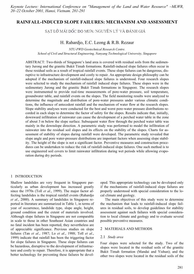
For the parametric study a combination of four differ-ent slope angles of 18°, 27°, 45° 63° (3H:1V, 2H:1V, 1H:1V, 0.5H:1V) and three different slope heights of 10, 20, and 40 m were analysed. These values were chosen based on a slope height of 10 m, and a slope angle of 27° (or 2H:1V), which are typical design height and angle used by the Public Works Department of Singapore for residual soil slopes. Generalized geometry of the slope used in the parametric study is shown in Figure 9. The slope material was assumed to be homogeneous, single layered with a saturated permeability of 1.0×10⁻⁴ m s–1. The shear strength properties of the slope material are given in Table V. The soil-water characteristic curves and the permeability function are shown in Figures 10 and 11, respectively. All other parameters remained constant.
The initial pore-water pressure distribution for each slope configuration was defined as a hydrostatic pore-water pressure profile with a limiting negative pore-water pressure of 75 kPa. This limit was selected based on field measurements of negative pore-water pressures and was imposed to prevent the generation of unrealistic pore-water pressures.
Table 4. Maximum and minimum factors of safety and loca-tion of critical slip surface for the slopes during the monitoring period
Slope Factor of safety Depth of critical slip surface (m)
Max. Min. Max. Min.
Yishun 3.2 2.0 3.2 3.2Mandai 2.0 1.4 3.2 3.1NTU-CSE 6.0 6.0 Interface between
Layer 1 and 2Interface betweenLayer 1 and 2
NTU-ANX 1.3 1.3 2.9 2.9
Fig. 8. Variation in factor of safety with time and rainfall for the Yishun slope
Table 5. Shear strength parameters for the parametric study
Combination c′(kPa)
φ′(deg)
φb
(deg)γ
kN/m3
1 10 26 26 20
Fig. 9. Generalized geometry of slope for parametric study
288
The top boundary was specified as a flux boundary. A
rainfall intensity of 80 mm hr−1 (2.2×10⁻⁵ m s−1, typical rainfall rate during heavy rainfalls in Singapore) was ap-plied from time equal to 0 hour until time equal to 4 hours. A rainfall intensity of about zero (1.0×10⁻¹² m s−1) was then applied for a further period of 10 days which al-lowed the water that infiltrated the slope to redistribute. The top boundary condition and all other parameters (ex-cept slope angle and height) were the same for all analy-ses.
The results from the seepage analyses of the paramet-ric study showed that the slope height, angle and the tran-sient pore-water pressure distribution influence the stabil-ity of a slope. Infiltration characteristics were similar for each of the slope angles and slope heights examined.
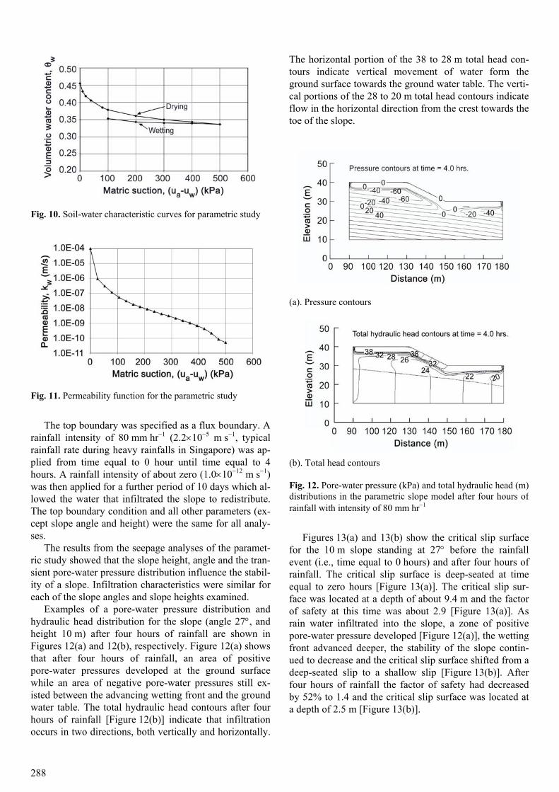
Examples of a pore-water pressure distribution and hydraulic head distribution for the slope (angle 27°, and height 10 m) after four hours of rainfall are shown in Figures 12(a) and 12(b), respectively. Figure 12(a) shows that after four hours of rainfall, an area of positive pore-water pressures developed at the ground surface while an area of negative pore-water pressures still ex-isted between the advancing wetting front and the ground water table. The total hydraulic head contours after four hours of rainfall [Figure 12(b)] indicate that infiltration occurs in two directions, both vertically and horizontally.
The horizontal portion of the 38 to 28 m total head con-tours indicate vertical movement of water form the ground surface towards the ground water table. The verti-cal portions of the 28 to 20 m total head contours indicate flow in the horizontal direction from the crest towards the toe of the slope.
Figures 13(a) and 13(b) show the critical slip surface
for the 10 m slope standing at 27° before the rainfall event (i.e., time equal to 0 hours) and after four hours of rainfall. The critical slip surface is deep-seated at time equal to zero hours [Figure 13(a)]. The critical slip sur-face was located at a depth of about 9.4 m and the factor of safety at this time was about 2.9 [Figure 13(a)]. As rain water infiltrated into the slope, a zone of positive pore-water pressure developed [Figure 12(a)], the wetting front advanced deeper, the stability of the slope contin-ued to decrease and the critical slip surface shifted from a deep-seated slip to a shallow slip [Figure 13(b)]. After four hours of rainfall the factor of safety had decreased by 52% to 1.4 and the critical slip surface was located at a depth of 2.5 m [Figure 13(b)].
Fig. 10. Soil-water characteristic curves for parametric study
Fig. 11. Permeability function for the parametric study
(a). Pressure contours
(b). Total head contours
Fig. 12. Pore-water pressure (kPa) and total hydraulic head (m) distributions in the parametric slope model after four hours of rainfall with intensity of 80 mm hr−1

289
The factors of safety and respective depths of critical slip surface over time for the 27° slope with different heights are shown in Figures 14(a) and 14(b), respec-tively. A few trends are apparent from these plots. Prior to the commencement of rainfall slopes with lower height had a higher factor of safety [Figure 14(a)] and the depths of critical slip circles are deep seated for slopes with greater heights [Figure 14(b)]. As rainfall continued posi-tive pore-water pressures developed (between 1 and 4 hours) and these trends changed. Both the stability and the depth of critical slip surface decreased over time dur-ing rainfall due to infiltration and reached minimum val-ues at the end of four hours, and increased over time dur-
ing redistribution [between 4 and 28 hours, see Figures 14(a) and 14(b)]. It is also evident that after the development of positive pore-water pressures (time = 4 hours) due to infiltration, all slopes of 27o angle regard-less of their heights had about the same factor of safety and the same depth of critical slip surface. This implies that once positive pore-water pressures have developed, slope height has little control on the factor of safety and the depth of critical slip surface. These examples showed that the transient pore-water pressure distribution appears to be a key triggering mechanism behind rainfall-induced slope failures. Infiltration leads to the development of positive pore-water pressure zones in a slope. After a pe-riod of time when the positive pore-water pressure zone has developed, the critical slip surface of the slope be-comes a shallow slip surface passing through the positive pore-water pressure zone.
(a). Time = 0 hour
(b). Time = 4 hours
Fig. 13. Location of critical slip circle for the parametric slope model at different times subjected to a rainfall intensity of 80 mm hr−1
(a). Factor of safety
(b). Depth of critical slip circle
Fig. 14. Time series of factor of safety and depth of critical slip circle during rainfall and redistribution for a 27o slope

290
3.6 Slope stability assessment chart
The results of the numerical modeling were used to pre-pare preliminary assessment charts for slope stability. The charts are useful for a preliminary assessment of slope stability against rainfall-induced slope failure for typical residual soil slopes in Singapore. As an example, for a 10 m slope and 27º slope angle, the assessment charts are shown in Figure 15. Figure 15(a) shows the transient pore-water pressure distributions in the slope subjected to a rainfall of 80 mm hr−1 for different dura-tions. Figures 15(b) and 15(c) show the respective factors of safety for different slope angles and heights respec-tively, as calculated using the computed transient pore-water pressure distributions.
The charts shown in Figures 15(b) and 15(c) consist of several lines, each line representing the factor of safety versus the varied parameter (e.g. slope angle, slope height, rainfall duration). The charts can be used to de-termine the factor of safety of slopes with slope heights of 10, 20 and 40 metres and varying slope angles. The charts are however, valid only for residual soil slopes whose parameters are similar to the parameters used in the parametric study. They may not necessarily be satis-factory for other values of slope, soil, climatic, and hy-drologic parameters.
4 CONCLUSIONS
The field measurements and parametric analyses that were performed for this study indicate that mechanism of rainfall-induced slope failures in Singapore is as follows:
(i) Infiltration from rainfall decreases matric suctions, and eventually leads to the development of positive pore-water pressures (i.e., perched water tables), particularly at shallow depths (i.e., top 3 m). The increase in pore-water pressure effectively decreases the shear strength of the soil, making it more susceptible to failure.
(ii) The parametric study revealed that slope angle and pore-water pressure distributions are important factors to be considered when assessing the stability of a slope against a rainfall-induced slope failure. The height of the slope, on the other hand, is not a significant factor. The pore-water pressure distribution can be analysed using seepage analyses through an unsaturated soil. Appropri-ate unsaturated hydraulic properties (i.e., soil-water char-acteristic curve and permeability function) together with flux boundary conditions should be used in the seepage analyses.
(a) Transient pore-water pressure distributions in a 10m slope standing at 27º subjected to rainfall of 80 mm hr−1 and various duration.
(b) Respective factor of safety versus slope angle calculated using (a).
(c) Respective factor of safety versus slope height calculated using (a)
Fig. 15. Charts for preliminary assessment of slope stability

291
5 RECOMMENDATIONS
Preventive measures and construction procedures can be undertaken to reduce the possibility of a rainfall-induced slope failure from occurring. Methods for stabilizing re-sidual soil slopes in Singapore that have proven to be successful in the past include soil nailing/anchoring, drainage grids (i.e., just below the surface), re-grading and compacting to a flatter angle. One additional preven-tive method that shows promise is the development of engineered soil covers. Engineered soil covers can be de-signed to limit infiltration during wet periods while still allowing for evaporation during dry periods. Further re-search is required in the area of engineered soil covers to develop viable options for the local soils and climatic conditions of Singapore.
6 ACKNOWLEDGEMENTS
The work was funded by a research grant from the Na-tional Science and Technology Board, Singapore (NSTB 17/6/16: Rainfall induced slope failures). The authors gratefully acknowledge the assistance of Mr. JM Gasmo, Mr. MS Deutscher, Dr. David Toll and Mr. Ilias Tsaparas for the success of the project. The assistance of the NTU Geotechnics Laboratory staff and PWD staff in the field and laboratory work of this study is gratefully acknowl-edged.
7 REFERENCES Geo-Slope (1998a). Slope/w Version 4.21 Users Manual,
GEO-SLOPE International Ltd., Calgary, Alberta, Canada.
Geo-Slope (1998b). Seep/w Version 4.21 Users Manual, GEO-SLOPE International Ltd., Calgary, Alberta, Canada.
Lo, K.W., Leung, C.F.,Hayata, K., Lee, S.L. (1988). Sta-bility of excavated slopes in the weathered Jurong formation of Singapore. Proc. 2nd International Con-ference on Geomechanics in Tropical Soils, Singa-pore. Balkema, Rotterdam. pp. 277−284.
Meteorological Service Singapore. (1997). Summary of Observations. An annual publication of Meteorologi-cal Service Singapore.
Rahardjo, H., Leong, E.C. Deutscher, M.S. Gasmo, J.M. Tang, S.K. (2000). Rainfall-Induced Slope Failures. Geotechnical Engineering Monograph 3. NTU-PWD Geotechnical Research Centre, Nanyang Technologi-cal University, Singapore. 86 pp.
Tan, S.B., Tan, S.L.,Lim, T.L.,Yang, K.S. (1987). Land-slide problems and their control in Singapore. Proc.9th Southeast Asian Geotechnical Conference. Bangkok. pp. (1):25−36.
Toll, D.G., Rahardjo, H., Leong, E.C. (1999). Landslides in Singapore. In Landslides, Slope Stability & The Safety of Infrastructures. 2nd International Conference on Landslides Slope Stability & The Safety of Infra-structures. pp. 269−276.