radcomms 2012, session one: sensing technologies - dr sue barrell, bureau of meteorology
TRANSCRIPT

1RadComms 2012
Fingerprints of Nature
Sensing Technologies
Dr Sue Barrell
Australian Bureau of Meteorology

2RadComms 2012
Overview
Earth Observations o Fingerprints of Nature
Sensing Technologieso Principles of Active and Passive Sensorso Space-based
• Example – Global Precipitation Mission (GPM) Satellite
o Surface-based• Example – Radiometer Physics GmbH instrument
Implications of Radio Frequency Interference (RFI) for Passive sensing. Economic Value of Earth Observations
o Global and Australian Perspectives Example of Applications and Benefits
o Effects on NWP output – comparison of forecasts generated with and without satellite data.

3RadComms 2012
Earth Observations
Measurements of the planet’s fundamental constituents and processes, including:
o Atmospheric water vapour and cloud liquid watero Precipitation including rain, ice (hail) and snow o Atmospheric temperature profiles o Soil moistureo Ocean salinity o Wind speed and directiono Land and sea surface temperatureo Cloud temperature and covero Ice covero Vegetation biomasso Atmospheric chemistry, e.g. carbon, nitrogen and sulphur-based gases (CO2, CO,
NO, SO2, etc.) o Suspended particulate matter (aerosols), e.g. volcanic ash, dust

4RadComms 2012
Earth Observations
Fingerprints of Nature
o Fixed frequency bands of electromagnetic radiation produced at the molecular level.
o Emissions at microwave frequencies are produced by transitions between unique quantised rotational modes of molecules such as water and oxygen.
o Emissions are only just above the natural background noise level, making their detection highly susceptible to interference from artificial sources.
o Microwave and sub-millimetre wave bands used for passive Earth observations range from 1 GHz to 1000 GHz (1 THz).

5RadComms 2012
Sensing Technologies
Principles of Passive and Active Sensingo Passive Microwave Sensors (Radiometers)
… measure electromagnetic radiation at microwave frequencies emitted by constituents of the Earth and its atmosphere.
o Global frequency allocations needed to measure these constituents are determined by the frequencies of their molecular emissions.
o Microwave radiometers are mainly utilised on low earth orbit satellites
o Surface-based radiometers are increasingly being employed to obtain tropospheric water vapour and temperature profiles.

6RadComms 2012
Sensing Technologies
o Active Sensors… receive signals that they have transmitted, after these
signals have been reflected by land/ocean surfaces, by atmospheric hydrometeors, or by variations in the refractive index of air.
o Terrestrial, airborne, and spaceborne radars.o The concept of “fingerprints of nature” also applies, although
less stringently, to active sensing, as optimal frequency ranges are determined by the phenomenon to be measured.
• e.g. A weather radar’s frequency (wavelength) is related to the size and properties of the hydrometeors to be detected and the required range as permitted by atmospheric attenuation.
7RadComms 2012
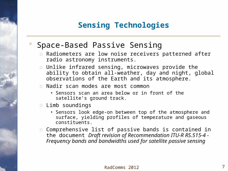
Sensing Technologies
Space-Based Passive Sensingo Radiometers are low noise receivers patterned after radio
astronomy instruments.o Unlike infrared sensing, microwaves provide the ability to obtain all-
weather, day and night, global observations of the Earth and its atmosphere.
o Nadir scan modes are most common • Sensors scan an area below or in front of the satellite’s ground track.
o Limb soundings • Sensors look edge-on between top of the atmosphere and surface,
yielding profiles of temperature and gaseous constituents.
o Comprehensive list of passive bands is contained in the document Draft revision of Recommendation ITU-R RS.515-4 - Frequency bands and bandwidths used for satellite passive sensing

8
Sensing Technologies
ATMOSPHERIC OPACITY IN FREQUENCY RANGE 1-275 GHz
1.E-07
1.E-06
1.E-05
1.E-04
1.E-03
1.E-02
1.E-01
1.E+00
1.E+01
1.E+02
1.E+03
1 26 51 76 101 126 151 176 201 226 251
Frequency (GHz)
Ver
tica
l op
acit
y (d
B)
Minor constituents
OxygenWater vapour tropical
Water vapour sub-arctic

9
Sensing Technologies
o Multiple channels are required on and between emission peaks in order to resolve signals for each parameter of interest from the total signal received at the radiometer.
o Multiple channels across pressure-broadened emission peaks is used to derive profiles.
Microwave Channels used by the AMSU-A Instrument on AQUA
Black plot = Total Signal ReceivedColoured plots are contributions from :
WV – Water VapourLW – Liquid Water (Cloud)O2 - Oxygen

10RadComms 2012
Sensing Technologies
Space-Based Active Sensingo Radar signals are projected on the Earth below a satelliteo Reflected signals contain information on surface and atmospheric
characteristics and components.
o Frequencies range from below 1 GHz for surface measurements to about 150 GHz for cloud measurements.
o Specific frequency requirements are less rigid than for passive sensing.o Applications include:
• Synthetic Aperture Radar (SAR) (medium-bandwidth ~100 MHz)• Radar altimeter (high bandwidth ~ 600MHz for centimetre-level accuracy)• Radar scatterometer (narrow-band ~ 1MHz)• Precipitation radar (medium-bandwidth ~100 MHz)• Cloud-profiling radar (medium-bandwidth ~100 MHz)
o Active sensors are used in concert with passive systems to compensate for the effects of certain surface characteristics such as roughness.

11RadComms 2012
Sensing Technologies
Example of a space-based sensing platform- Planned Global Precipitation Measurement (GPM) Satellite
o Cooperative US/Japanese Earth science mission with the prime agencies of NASA and JAXA respectively.
o Follow-on and expanded mission to the extremely successful TRMM (Tropical Rainfall Measuring Mission).
o GPM will build on knowledge of tropical rainfall gained from TRMM and extend it to improve climate, weather, and hydrological forecasts on a global basis.
o Long-term objective is a constellation of satellites to obtain frequent precipitation measurements on a global basis.
o Employs both active and passive instruments.• Two phased array precipitation radars (DPR) operating at 35.5 GHz (Ka band)
and 13.6 GHz (Ku band) for sensing precipitation rate and type.
• A passive microwave imager (GMI) for sensing water on the following channels - 10.65, 18.7, 23.8, 36.5, 89.0, 165.5, and 183.31 GHz.

12RadComms 2012
Source: www.eoportal.org/directory/pres_GPMGlobalPrecipitationMeasurement.html
→

13RadComms 2012
Sensing Technologies
Surface-Based Passive Sensing
o Surface microwave radiometers operate on the same principles as space-based radiometers.
o Offer more accurate atmospheric water content and temperature sensing of the lower parts of the atmosphere (troposphere).
o Provide vertical profiles of atmospheric temperature and humidity up to ~10 km altitude.
o Liquid Water path (LWP).
o Integrated Water Vapor (IWV).
o Typically utilise multiple channels in 22-31 GHz range for water, and multiple channels in 51-58 GHz range for temperature (derived from oxygen absorption lines).

14RadComms 2012
Sensing Technologies
Surface-Based Active Sensingo Doppler and non-Doppler weather radars
• Small fraction of transmitted energy is reflected back to the receiver by hydrometeors.
• Both types of radar provide precipitation intensity and rainfall estimates, with Doppler systems also providing wind speed and direction from the radial movement of hydrometeors relative to the radar.
• Application requirements determines the frequencies used: S-band (2700-2900 MHz) – low attenuation gives longer range. C-band (5600-5650 MHz) – higher attenuation results in shorter range than S-band. X-band (9300-9500 MHz) – high attenuation but short wavelength (~3cm) can yield drop
size distribution. Dual polarisation capability can discriminate between water and ice.
o Wind profiling radars • Provide wind speed and direction profile from near ground to the stratosphere
directly above the radar, depending on the frequency.• Application requirements determines the frequencies used:
Lower VHF (50 MHz) for ~20 km height range - stratosphere UHF (1 GHz) for ~5 km range – lower troposphere.

15RadComms 2012
Sensing Technologies
Tennant Creek 50 MHz Stratospheric/Tropospheric Radar Adelaide S-Band Doppler Radar

16RadComms 2012
Implications of Radio Frequency Interference (RFI) for Passive Sensing
Three categories of RFI from the Earth Observations Perspective:o High levels
• Obviously inconsistent with natural radiation.• Data can be rejected by quality control but information on phenomena being sensed is lost.
o Very low levels, below ITU-R protection criteria • Cannot be detected by passive sensors and has no impact on output products.
o Low levels at or just above noise floor• Cannot be discriminated from natural emissions and therefore represents a serious problem,
as degraded data would be seen as valid.
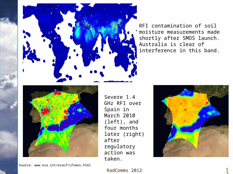
Example of RFI in the 1.4-1.427 GHz EESS Passive Bando European Space Agency’s SMOS Mission (Soil Moisture and Ocean
Salinity) launched in 2009.o Mainly a problem over land with contamination of soil moisture data from
radars, fixed links and wireless camera monitoring systems.o Sources of interference
• Illegal in-band emissions.• Excessive out-of-band emissions from systems operating in adjacent bands.
17RadComms 2012
RFI contamination of soil moisture measurements made shortly after SMOS launch. Australia is clear of interference in this band.
Severe 1.4 GHz RFI over Spain in March 2010 (left), and four months later (right) after regulatory action was taken.
Source: www.esa.int/esaLP/LPsmos.html

18RadComms 2012
Economic Value of Earth Observations
The protection of spectrum used for passive and active Earth observations requires a global perspective.
o Comment heard several times at international meetings during the lead-up to WRC-12 – “We don’t have any satellites that use these bands, so why should we worry about them?”
o Earth observations, whether made from space or from terrestrial networks, are shared globally between meteorological agencies free of charge, for the benefit of all countries in protecting life and property.
Australian Perspectiveo Earth observations sector contributes an estimated $3.3 billion1 to the GDP as of
Sep 2010, rising to $4 billion by 2015.o Entirely dependent on Earth observation satellites funded and launched by other
countries.o In return we provide science and mission support to these countries:
• Validation and calibration of sensors, e.g. CP2 radar in Brisbane for GPM, OzNet Hydrological monitoring network (Monash and Melbourne Universities) for SMOS.
• Satellite command and control, e.g. Bureau Turn Around Ranging Station (TARS) for Chinese FENGYUN geostationary satellites.
1. 2010, The economic value of earth observation from space, ACIL Tasman

19RadComms 2012
Example - Impact of Satellite Information on Numerical Weather Prediction (NWP)
A study was undertaken of the severe weather event on 9 Nov 2011 when Melbourne and eastern Victoria experienced thunderstorms, heavy rain, hail and flash flooding.
Bureau’s ACCESS NWP model was used to generate rainfall forecast three days in advance for two scenarios:1. No satellite data - only surface-based and upper-air data including ACARS.
2. Include satellite data comprising microwave (AMSU), IR (AIRS, ATOVS, IASI) and ASCAT scatterometer, as well as data for scenario 1.
Left panel plot is forecast 24hr accumulated rainfall from 9am on 9 Nov to 9am on 10 Nov.
Right panel plot is for verification and is derived from actual rain gauge measurements – same for both slides.

20RadComms 2012
Access NWP model run for severe weather event in Victoria without satellite information.

21RadComms 2012
Access NWP model run for severe weather event in Victoria with satellite information.

22
Thank you