search.jsp?r=20150018076 2019-03-17t16:08:12+00:00z role ... · role and evolution of nasa's...
TRANSCRIPT

Role and Evolution of NASA's Earth Science Data Systems
H. K. Ramapriyan Science Systems and Applications, Inc./
NASA GSFC ESDIS Project [email protected] 1
IEEE EDS/CAS Chapter – Camarillo, CA
August 19,2015
https://ntrs.nasa.gov/search.jsp?R=20150018076 2019-03-21T19:18:07+00:00Z

Acknowledgement
This presentation is the result of my long association with the NASA Earth Science Data and Information System Project It has evolved over the years with inputs from several members of the Project and has been used in various forms in many presentations My present work with the ESDIS Project is supported under contract number NNG15HQ01C with NASA Goddard Space Flight Center
2

Topics
NASA’s Earth Science Data Systems • Core and Community Capabilities
Earth Observing System Data and Information System (EOSDIS) • Scope and Context • System of systems
Recent Developments EOSDIS Evolution - Community inputs IEEE GRSS Earth Science Informatics Technical Committee and EOSDIS Conclusion
3

NASA’s Earth Science Data Systems
“Advance understanding of Earth and develop technologies to improve the quality of life on our home planet.” -- 2014 NASA Strategic Plan NASA’s Earth Science Data Systems directly support this strategic goal by providing end-to-end capabilities to deliver data and information products to users NASA’s Earth Science Data and Information Policy promotes usage of data by the community • No period of exclusive access - Data are available after initial
checkout • Data available at no cost to all users on a non-discriminatory
basis except where agreed upon with international partners
4

Core and Community Capabilities
Core Capabilities Basic operational capabilities to process, archive, manage
and distribute data from NASA missions Earth Observing System Data and Information System (EOSDIS) Precipitation Processing System – NASA GSFC Laboratory for Atmospheric and Space Physics (LASP) Interactive
Solar Irradiance Data Center - University of Colorado CloudSat Data Processing Center – Colorado State University
Community Capabilities Peer-review-selected projects New data products – Making Earth System Data Records for
Use in Research Environments (MEaSUREs) Research in Earth Science Informatics to feed into the
evolution of the core components Applied Information Systems Technology (AIST) Advancing Collaborative Connections for Earth System Science
(ACCESS)
5

EOSDIS
Major core capability in NASA’s Earth Science Data Systems Program. Provides end-to-end capabilities for managing NASA’s Earth science data. Science Operations Science data processing Data management Interoperable distributed data archives On-line data access services Earth science discipline-oriented user services
Network Data Transport to distributed system elements
6

Extensive Data Collection > 8200 data types (collections) • Land
» Cover & Usage » Surface temperature » Soil moisture » Surface topography
• Atmosphere » Winds & Precipitation » Aerosols & Clouds » Temperature & Humidity » Solar radiation
• Ocean » Surface temperature » Surface wind fields &
Heat flux » Surface topography » Ocean color
• Cryosphere » Sea/Land Ice & Snow Cover
7
• Human Dimensions » Population & Land Use » Human & Environmental Health » Ecosystems

Global Net Primary Productivity
8
Net Primary Productivity is the amount of carbon absorbed by plants minus carbon released by plants, measured in grams of carbon per square meter per day. Image shows the averages over May 15, globally. Credits - Image made by Reto Stockli, NASA's Earth Observatory Team, using data provided by the MODIS Land Science Team

Top of Atmosphere Radiation
At the top of the atmosphere (TOA), incoming and outgoing radiation determine Earth’s average temperature. This image shows averaged net downward TOA radiation from the Clouds and Earth’s Radiant Energy System (CERES) instrument from 2001 to 2010. The Southern Hemisphere receives more net radiation than the Northern Hemisphere. (Courtesy D. Frierson et al., 2013, Nature Geoscience) – accessed through https://earthdata.nasa.gov/user-resources/sensing-our-planet/rooting-out-rainfall 9

Air Quality in Northeastern China (1 of 2)
Image acquired by Moderate Resolution Imaging Spectroradiometer (MODIS) on NASA’s Terra satellite on January 3, 2013 - NASA image courtesy Jeff Schmaltz, LANCE MODIS Rapid Response.
10

Air Quality in Northeastern China (2 of 2)
11
Image acquired by Moderate Resolution Imaging Spectroradiometer (MODIS) on NASA’s Terra satellite on January 14, 2013 - NASA image courtesy Jeff Schmaltz, LANCE MODIS Rapid Response.

Sea Surface Salinity
This image of Aquarius sea surface salinity (SSS) measurements averaged for 2012 shows a global color scale of salinity intensity. Warm colors mark stronger salinity values. Values are shown in a range between 30 grams per kilogram (purple) and 40 grams per kilogram (red). (Courtesy N. Kuring/NASA) – accessed through https://earthdata.nasa.gov/user-resources/sensing-our-planet/salt-of-the-sea.
12
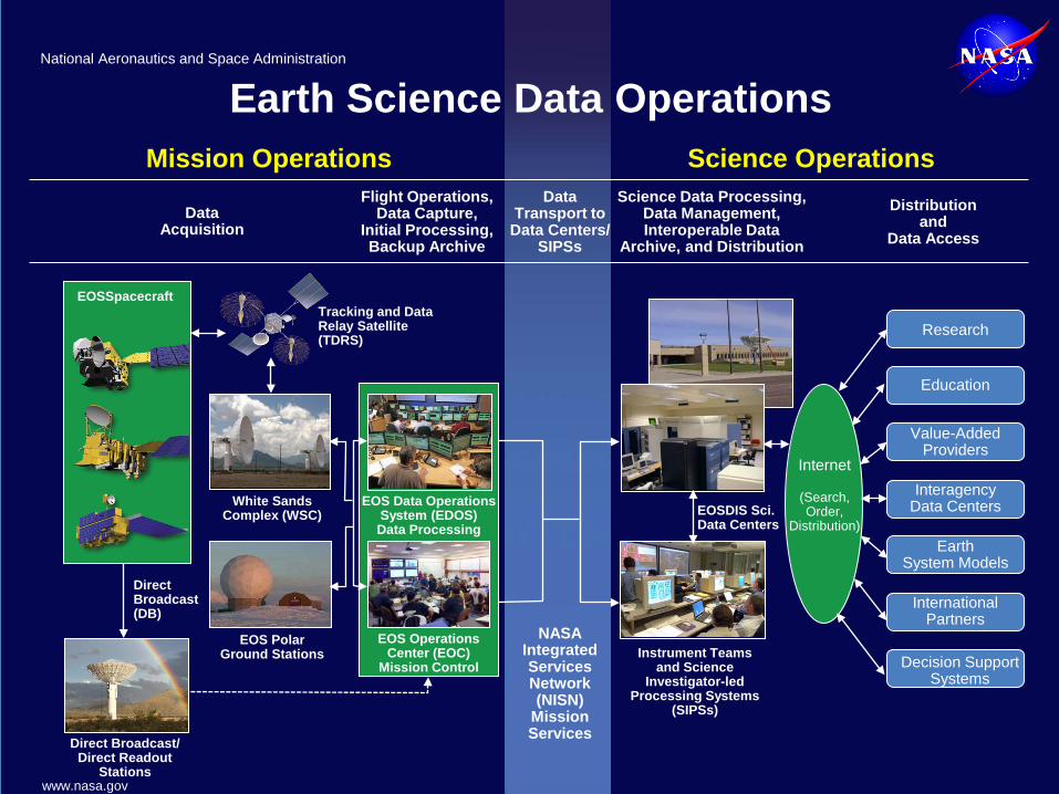
Mission Operations Science Operations
Earth Science Data Operations
Data Acquisition
Flight Operations, Data Capture,
Initial Processing, Backup Archive
Data Transport to
Data Centers/ SIPSs
Science Data Processing, Data Management, Interoperable Data
Archive, and Distribution
Distribution and
Data Access
NASA Integrated Services Network (NISN)
Mission Services
Research
Education
Value-Added Providers
Earth System Models
International Partners
Decision Support Systems
Internet
(Search, Order,
Distribution)
Tracking and Data Relay Satellite (TDRS)
Instrument Teams and Science
Investigator-led Processing Systems
(SIPSs)
White Sands Complex (WSC)
EOS Polar Ground Stations
Direct Broadcast (DB)
Direct Broadcast/ Direct Readout
Stations
EOSDIS Sci. Data Centers
EOS Data Operations System (EDOS) Data Processing
EOS Operations Center (EOC)
Mission Control
EOSSpacecraft
Interagency Data Centers
National Aeronautics and Space Administration
www.nasa.gov

EOSDIS – A System of Systems
Instrument and science expertise needed to process data • Most EOS standard products are generated at Science Investigator-led
Processing Systems (SIPSs) under supervision of PIs Earth Science discipline knowledge needed to ensure data stewardship • Processed data are archived and distributed by discipline-specialized
EOSDIS Science Data Centers (Distributed Active Archive Centers – DAACs)
Expertise in system interoperability needed to provide cross-system (interdisciplinary) data access • EOS Clearing House (ECHO) middleware and associated clients provide
search and access to data across all EOSDIS Science Data Centers EOSDIS data collections are diverse: • Primary sources are instruments on-board NASA spacecraft • Ancillary, airborne, in-situ and socio-economic data • Data from international partners • Comprehensive approach to multi-discipline science • Feed growing need by models (e.g., climate models)
14

15
EOSDIS Facilities
Data centers, collocated with centers of science discipline expertise, archive and distribute
standard data products produced by Science Investigator-led Processing Systems (SIPSs)
ASF DAAC SAR Products Sea Ice, Polar
Processes
SEDAC Human Interactions
in Global Change
LP DAAC Land Processes
& Features
PO.DAAC Ocean Circulation
Air-Sea Interactions
ASDC Radiation Budget, Clouds, Aerosols, Tropo Chemistry
ORNL DAAC Biogeochemical
Dynamics, EOS Land Validation
GES DISC Atmos Composition &
Dynamics, Global Modeling, Hydrology,
Radiance
LAADS/ MODAPS
Atmosphere
OBPG Ocean Biology & Biogeochemistry
GHRC Hydrological Cycle &
Severe Weather
CDDIS Crustal Dynamics
Solid Earth NCAR, U of Col. HIRDLS, MOPITT GSFC
GLAS, MODIS, OMI, OBPG
GHRC AMSR-E, AMSR2
JPL MLS, TES
NSIDC DAAC Cryosphere, Polar
Processes
SIPSs
Key Data
Center
Near Real-time Element

EOSDIS Key Metrics
16 0.00
2.00
4.00
6.00
8.00
10.00
12.00
FY00 FY01 FY02 FY03 FY04 FY05 FY06 FY07 FY08 FY09 FY10 FY11 FY12 FY13 FY14
Volu
me
(PBs
)
Multi-year Total Archive Volume (PBs) Trend
EOSDIS Science Data Volume Progression
0
200
400
600
800
1,000
1,200
FY00 FY01 FY02 FY03 FY04 FY05 FY06 FY07 FY08 FY09 FY10 FY11 FY12 FY13 FY14
Prod
uct D
istr
ibut
ed (M
illio
ns)
Multi-Year Product Distribution Trend
EOSDIS Science Data Products Distribution FY00
through FY14
Atmosphere, 291.8
Geodeosy/Solid Earth, 145.2
Land, 142.9
Hydrology, 130.7
Other, 92.0
Ocean, 88.3
Terrestrial Ecology, 61.0
Radiance/Geolocation, 55.1
Raw Data, 21.7
Distribution by Discipline Product Counts (M)
(Oct 2013- Sep 2014)
EOSDIS FY2014 Metrics (Oct. 1, 2013 to Sept. 30, 2014)
Unique Data Sets 8,292
Distinct Users of EOSDIS Data and Services
2.0 M
Web Site Visits 2.3 M Average Archive Growth 6.4 TB/day Total Archive Volume 9.1 PB
End User Distribution Products 1,028 M End User Average Distribution Volume 27.9 TB/day

Recent and On-Going Developments (1 of 2)
Land and Atmosphere Near real-time Capability for EOS (LANCE) Coherent Web Interface: http://earthdata.nasa.gov is operational • Provides a unified view of NASA Earth science data system
resources • Consolidates 14 web sites, and provides links to various ways
to access data and to related external sites User Registration System – uniform approach to registration across EOSDIS components Global Imagery Browse Services (GIBS) • Standards-based, full resolution, interactive browse capability • Accessible from http://earthdata.nasa.gov wiki
17
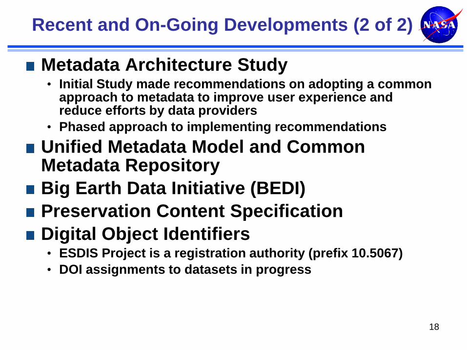
Recent and On-Going Developments (2 of 2)
Metadata Architecture Study • Initial Study made recommendations on adopting a common
approach to metadata to improve user experience and reduce efforts by data providers
• Phased approach to implementing recommendations Unified Metadata Model and Common Metadata Repository Big Earth Data Initiative (BEDI) Preservation Content Specification Digital Object Identifiers • ESDIS Project is a registration authority (prefix 10.5067) • DOI assignments to datasets in progress
18

• Building on existing EOSDIS elements provides data from MODIS, OMI, AIRS, MLS, and AMSR instruments in near real-time (< 3 hours from observation)
• Utilizes software for Standard Science Products, but relaxes requirements for ancillary data inputs
• High operational availability
Land, Atmosphere Near-real-time Capability for EOS (LANCE)
19
• Applications of LANCE data include:
– Numerical weather & climate prediction/forecasting
– Monitoring of Natural Hazards
– Disaster Relief
– Agriculture
– Air quality
– Homeland Security

LANCE Latencies
20
Over the four weeks indicated above, >97% of near real-time data requests were satisfied within 3 hours.

EOSDIS Evolution: Earthdata Website
21
What is the Earthdata Website?
• Earthdata was created as a sustainable,
evolvable, and reliable Website that represents our community’s needs for NASA Earth science data and information.
• It was designed to support collaboration within and between organizations, and for development and integration of new applications.
• It addresses the need for a coherent and comprehensive Web presence of the Earth Science Data Systems Program.
• See Earthdata at https://earthdata.nasa.gov/.
Benefits of the Earthdata Website:
• Better represents EOSDIS programmatic
investments and capabilities. • Presents data centers more clearly as elements
within a larger system of systems. • Facilitates multidisciplinary research and data
integration. • More quickly responds to emerging technologies • Provides a platform for demonstration of
interoperability throughout all of our systems.
2011
2012
2013
2014
2015
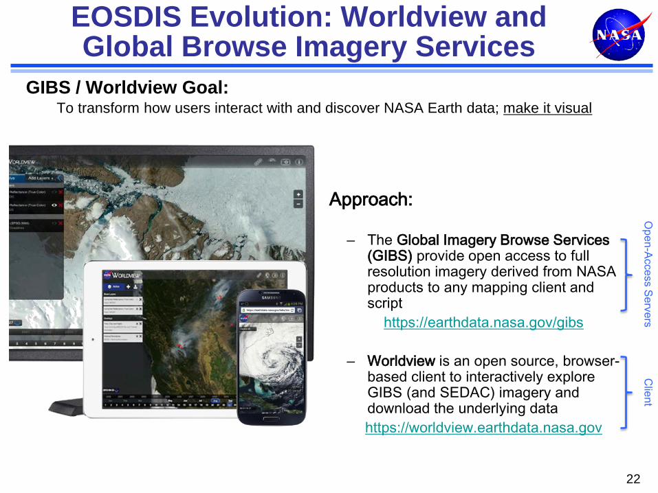
EOSDIS Evolution: Worldview and Global Browse Imagery Services
22
GIBS / Worldview Goal: To transform how users interact with and discover NASA Earth data; make it visual
Approach:
– The Global Imagery Browse Services (GIBS) provide open access to full resolution imagery derived from NASA products to any mapping client and script
https://earthdata.nasa.gov/gibs
– Worldview is an open source, browser-based client to interactively explore GIBS (and SEDAC) imagery and download the underlying data https://worldview.earthdata.nasa.gov
Open-Access Servers
Client

Global Image Browse Service (GIBS)
Goal: “Parameter Visualizations” for all EOSDIS Imagery Standardized access via OGC WMTS / TWMS / WMS / KML Source code for the GIBS OnEarth server and sample code available at the GIBS GitHub site Repository of pre-prepared, hierarchically stored imagery to maximize performance for “full-resolution” browse Clients can be built to use and display images in GIBS – WorldView is an example
23

Worldview: Reference Client for GIBS http://earthdata.nasa.gov/worldview http://earthdata.nasa.gov/gibs

EOSDIS Evolution - Community Inputs
EOSDIS Advisory Panel – aka Data Panel (early to mid-1990’s) • adhere to a flexible, distributed, portable, evolutionary
design; • distribute data products by appropriate high-bandwidth
communication or other media; • operate prototypes in a changing experimental
environment Distributed architecture with DAACs Version 0 working prototype
NRC Review (1995) • “Responsibility for product generation and publication
and for user services should be transferred to a federation of partners selected through a competitive process open to all”
Working Prototype Earth Science Information Partners (ESIP) Federation
25

EOSDIS Evolution - Community Inputs
EOSDIS Review Group (1997) • Recommended “an adaptive approach which will be less centralized,
giving more responsibility to the PIs” Science Investigator-led Processing System (SIPSs)
New Data and Information Systems and Services (NewDISS) Strategy Team (1998 - 2002) • Six recommendations
• Clearly define components • Employ Infrastructure providing NASA-private sector liaisons • Employ competitive processes to select components • Empower science investigators for data system development, processing
archiving and distribution • Apply lessons learned from WP-ESIP Federation • Charter transition team
Core and Community Data Systems (Core: EOSDIS with DAACs; Community: REASoN projects ACCESS & MEaSUREs) ESIP Federation Strategic Evolution of Earth Science Enterprise (ESE) Data Systems (SEEDS) Study Earth Science Data System Working Groups (ESDSWG, 2004) 26
EOSDIS Evolution - Community Inputs
Evolution of EOSDIS Elements Study Team/ Technical Team (2005) • Developed “EOSDIS 2015 Vision” First step implementation during 2006-2008 – reallocated
functions, simplified system, increased automation, improved services, reduced operations costs
Vision tenets continue to be used as a checklist to assess progress of on-going improvements
DAAC User Working Groups (on-going) American Customer Satisfaction Index Surveys (annual)
27

EOSDIS Evolution - Community Inputs
Earth Science Data System Working Groups (on-going) • focus on exploration and development of recommendations
derived from pertinent community insights • organized around key technology and information system
issues • Members from ACCESS, MEaSUREs, DAACs, ESDIS • 2014-2015 Working Groups
28
Digital Object Identifiers Geospatial Innovations Lab Open Source Provenance for Earth Science (PROV-ES) Technology Infusion Vision 2020 Visualization
Airborne Data ASCII for Science Data Cloud Computing Data-Intensive Architecture Data Preservation Practices Data Quality Data Recipes Dataset Interoperability

ESDSWG IEEE GRSS ESI TC
29
ESDSWG Earth Science Informatics Technical Committee Processing • Cloud Computing • Cloud Computing • Data-Intensive Architectures • Spatial/Temporal analysis Tools • Earth system modeling tools Archiving/ Stewardship • Data Preservation Practices • Preservation
• Data Quality • Quality • Digital Object Identifiers • Data stewardship • PROV-ES • Provenance Access • Recipes • Knowledge representation and information models
• Dataset Interoperability • Cyberinfrastructures
• Visualization • Interoperability and standardization
• Geospatial • Data discovery and access • Web-based services and analysis
• Geospatial information, knowledge, and decision support systems
Evolution/ Technology • Innovations Lab • Emerging information technologies and their applications in
the geosciences • Open Source • Sensor web and applications • Technology Infusion • spatial and process ontologies, vocabularies • Vision 2020 • semantic web Other • Airborne Data • Data and information policies • ASCII for Science Data

Vision 2020
30
Discovery and Access Usage Machine Level Discovery and Access for all
data.
Seamless Cross-agency Discovery.
Dataset Selection Guidance based on fitness for purpose.
Metadata Naming Conventions for Variables, Platforms, Instruments, Resolution…
Virtual Collections oriented around science problems.
Intelligent Tool Catalogs suggest tools to work with the data.
Publications are linked to data and tools that allow interactions with the data.
Automatic Mobile Data and Processing to achieve optimal performance.
Quantitative Quality for all data.
Reproducibility of research results with high precision.
Documentation is Concise, Comprehensive and Consistent for all data variables.
Capacity Building mechanisms for people with limited literacy in science, technology, and/or English.
Data Analysis at Scale over any arbitrarily defined area.
Dataset Upgrading for high-value datasets to fully support rich capabilities.
Integration NASA data can be combined with data from
other agencies and nations.
Combining Tools and Services within the community is easy.
Enable sharing of any scientific resource.
DRAFT

Common Metadata Repository (CMR)
Goals • Designed to improve the discovery and access of NASA data, CMR will
provide a single source of unified, high-quality, and reliable Earth Science metadata while merging the inventories of ECHO (EOS Clearing House) and GCMD (Global Change Master Directory) / IDN (International Directory Network). CMR will be the authoritative management system for all metadata of EOSDIS data holdings.
• CMR also provides a metadata model that documents vital elements that may be represented across various metadata formats and standards and unify them through core fields useful for data discovery and service invocations.
Current Status • By the end of CY 2015, CMR will have released the minimal set of
functionality that addresses the major goals laid out in a CMR Operations Concept including, sub-second search response, unification of ECHO and GCMD/IDN metadata, enhanced metadata management capabilities, and a unified (and expandable) metadata model representing collections, granules, and services.
Next Steps • In 2016, CMR will begin to implement enhancements to quality assessment
and assurance, search relevancy ranking, science keyword support and ontology and service initiation and chaining.
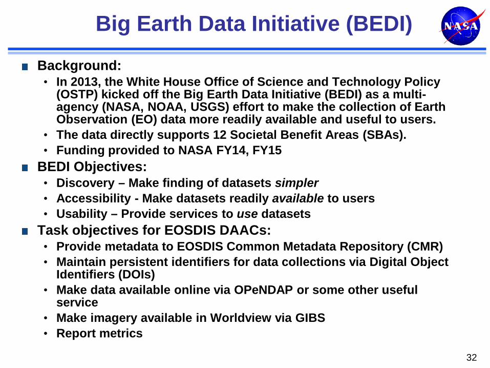
Big Earth Data Initiative (BEDI)
Background: • In 2013, the White House Office of Science and Technology Policy
(OSTP) kicked off the Big Earth Data Initiative (BEDI) as a multi-agency (NASA, NOAA, USGS) effort to make the collection of Earth Observation (EO) data more readily available and useful to users.
• The data directly supports 12 Societal Benefit Areas (SBAs). • Funding provided to NASA FY14, FY15
BEDI Objectives: • Discovery – Make finding of datasets simpler • Accessibility - Make datasets readily available to users • Usability – Provide services to use datasets
Task objectives for EOSDIS DAACs: • Provide metadata to EOSDIS Common Metadata Repository (CMR) • Maintain persistent identifiers for data collections via Digital Object
Identifiers (DOIs) • Make data available online via OPeNDAP or some other useful
service • Make imagery available in Worldview via GIBS • Report metrics
32

Preservation
NASA is not a “permanent archive” agency • Must maintain “research archive” for as long as data are used for scientific
research and/or transition responsibility to permanent archives • Research archive responsibilities persist well beyond lives of missions • NASA works with USGS and NARA for long-term preservation • NASA has to ensure data and other critical items are preserved and made
available to permanent archival agencies General requirements
• No loss of bits • Discoverability and accessibility • Readability • Understandability • Usability • Reproducibility of results
NASA has developed Preservation Content Specifications for Earth Science Data NASA is participating in Earth Science Information Partners (ESIP) Data Stewardship Committee, on an “emerging” Provenance and Context Content Standard
33

Categories of Content to be Preserved
1. Preflight/Pre-Operations: Instrument/Sensor characteristics including pre-flight/pre-operations performance measurements; calibration method; radiometric and spectral response; noise characteristics; detector offsets
2. Science Data Products: Raw instrument data, Level 0 through Level 4 data products and associated metadata
3. Science Data Product Documentation: Structure and format with definitions of all parameters and metadata fields; algorithm theoretical basis; processing history and product version history; quality assessment information
4. Mission Data Calibration: Instrument/sensor calibration method (in operation) and data; calibration software used to generate lookup tables; instrument and platform events and maneuvers
5. Science Data Product Software: Product generation software and software documentation
6. Science Data Product Algorithm Input: Any ancillary data or other data sets used in generation or calibration of the data or derived product; ancillary data description and documentation
7. Science Data Product Validation: Records, publications and data sets 8. Science Data Software Tools: product access (reader) tools.

Conclusion
Success of EOSDIS has been based on its ability to meet and adapt to needs of diverse Earth science communities • >20 years of diverse science data centers’ operation to meet
the needs of a growing user community • >16 years of support for EOS missions (starting with TRMM) • Working with new missions (e.g., EVS-1 aircraft
investigations, EV-2 missions, SMAP, ICESat-2, OCO-2) Some key areas in which improvements are required and incremental progress is being made: • Ease of discovery and access • Cross-organizational interoperability • Data inter-use • Ease of collaboration • Ease of citation of datasets • Preservation of provenance and context and making them
conveniently available to users
35

BACK-UP
36

EOSDIS ACSI Customer Satisfaction Survey 2014: Relative Rankings
37
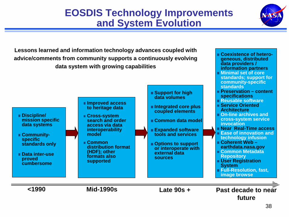
Discipline/ mission specific data systems Community-specific standards only Data inter-use proved cumbersome
Improved access to heritage data Cross-system search and order access via data interoperability model Common distribution format (HDF); other formats also supported
<1990 Mid-1990s
EOSDIS Technology Improvements and System Evolution
Support for high data volumes Integrated core plus coupled elements Common data model Expanded software tools and services Options to support or interoperate with external data sources
Coexistence of hetero-geneous, distributed data providers / information partners Minimal set of core standards; support for community-specific standards Preservation – content specifications Reusable software Service Oriented Architecture On-line archives and cross-system service invocation Near Real-Time access Ease of innovation and technology infusion Coherent Web – earthdata.nasa.gov Common Metadata Repository User Registration System Full-Resolution, fast, image browse
Late 90s + Past decade to near future
Lessons learned and information technology advances coupled with advice/comments from community supports a continuously evolving
data system with growing capabilities
38
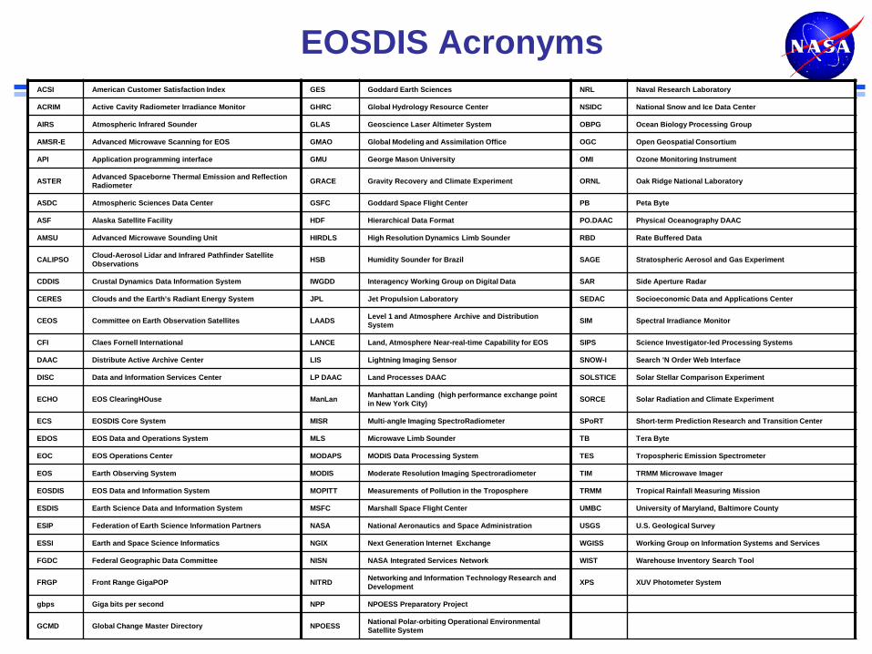
EOSDIS Acronyms ACSI American Customer Satisfaction Index GES Goddard Earth Sciences NRL Naval Research Laboratory
ACRIM Active Cavity Radiometer Irradiance Monitor GHRC Global Hydrology Resource Center NSIDC National Snow and Ice Data Center
AIRS Atmospheric Infrared Sounder GLAS Geoscience Laser Altimeter System OBPG Ocean Biology Processing Group
AMSR-E Advanced Microwave Scanning for EOS GMAO Global Modeling and Assimilation Office OGC Open Geospatial Consortium
API Application programming interface GMU George Mason University OMI Ozone Monitoring Instrument
ASTER Advanced Spaceborne Thermal Emission and Reflection Radiometer GRACE Gravity Recovery and Climate Experiment ORNL Oak Ridge National Laboratory
ASDC Atmospheric Sciences Data Center GSFC Goddard Space Flight Center PB Peta Byte
ASF Alaska Satellite Facility HDF Hierarchical Data Format PO.DAAC Physical Oceanography DAAC
AMSU Advanced Microwave Sounding Unit HIRDLS High Resolution Dynamics Limb Sounder RBD Rate Buffered Data
CALIPSO Cloud-Aerosol Lidar and Infrared Pathfinder Satellite Observations HSB Humidity Sounder for Brazil SAGE Stratospheric Aerosol and Gas Experiment
CDDIS Crustal Dynamics Data Information System IWGDD Interagency Working Group on Digital Data SAR Side Aperture Radar
CERES Clouds and the Earth’s Radiant Energy System JPL Jet Propulsion Laboratory SEDAC Socioeconomic Data and Applications Center
CEOS Committee on Earth Observation Satellites LAADS Level 1 and Atmosphere Archive and Distribution System SIM Spectral Irradiance Monitor
CFI Claes Fornell International LANCE Land, Atmosphere Near-real-time Capability for EOS SIPS Science Investigator-led Processing Systems
DAAC Distribute Active Archive Center LIS Lightning Imaging Sensor SNOW-I Search 'N Order Web Interface
DISC Data and Information Services Center LP DAAC Land Processes DAAC SOLSTICE Solar Stellar Comparison Experiment
ECHO EOS ClearingHOuse ManLan Manhattan Landing (high performance exchange point in New York City) SORCE Solar Radiation and Climate Experiment
ECS EOSDIS Core System MISR Multi-angle Imaging SpectroRadiometer SPoRT Short-term Prediction Research and Transition Center
EDOS EOS Data and Operations System MLS Microwave Limb Sounder TB Tera Byte
EOC EOS Operations Center MODAPS MODIS Data Processing System TES Tropospheric Emission Spectrometer
EOS Earth Observing System MODIS Moderate Resolution Imaging Spectroradiometer TIM TRMM Microwave Imager
EOSDIS EOS Data and Information System MOPITT Measurements of Pollution in the Troposphere TRMM Tropical Rainfall Measuring Mission
ESDIS Earth Science Data and Information System MSFC Marshall Space Flight Center UMBC University of Maryland, Baltimore County
ESIP Federation of Earth Science Information Partners NASA National Aeronautics and Space Administration USGS U.S. Geological Survey
ESSI Earth and Space Science Informatics NGIX Next Generation Internet Exchange WGISS Working Group on Information Systems and Services
FGDC Federal Geographic Data Committee NISN NASA Integrated Services Network WIST Warehouse Inventory Search Tool
FRGP Front Range GigaPOP NITRD Networking and Information Technology Research and Development XPS XUV Photometer System
gbps Giga bits per second NPP NPOESS Preparatory Project
GCMD Global Change Master Directory NPOESS National Polar-orbiting Operational Environmental Satellite System