r t·1' - sparwood · 2020-02-27 · the ocp is a municipal bylaw that sets out the long term...
TRANSCRIPT

DISTRICT OF SPARWOOD
BYLAW 1165
A bylaw to adopt an Official Community Plan
WHEREAS pursuant to Section 876(1) of the Local Government Act, a local government may, by bylaw, adopt one or more official community plans;
AND WHEREAS Council adopted an official community plan pursuant to Bylaw No. 869, 2002;
AND WHEREAS Council has deemed it appropriate to repeal Bylaw No. 869, 2002, and adopt a new official community plan;
AND WHEREAS the official community plan applies within the boundaries of the District of Sparwood (the "District") and will apply to an expansion of the boundaries of the District.
THEREFORE the Council in open meeting assembled enacts as follows:
1. This bylaw may be cited as, "Official Community Plan Bylaw 1165, 2015"
2. Schedule "A" attached hereto shall be adopted as the Official Community Plan of the District of Sparwood; and,
3. Bylaw No. 869, 2002 and all amendments thereto are hereby repealed.
READ A FIRST TIME THIS 16 DAY OF MARCH 2015
READ A SECOND TIME THIS 16 DAY OF MARCH 2015
ADVERTISED IN THE FREE PRESS ON 2 DAY OF APRIL 2015
SECOND READING RESCINDED THIS 7 DAY OF APRIL 2015
ADVERTISED IN THE FREE PRESS ON 9 DAY OF APRIL 2015
PUBLIC HEARING CANCELLED 15 DAY OF APRIL 2015
ADVERTISED IN THE FREE PRESS ON 16 DAY OF APRIL 2015
SECOND READING RESCINDED THIS 20 DAY OF JULY 2015
READ A FIRST TIME THIS 20 DAY OF JULY 2015
ADVERTISED IN THE FREE PRESS ON 6 DAY OF AUGUST 2015
ADVERTISED IN THE FREE PRESS ON 13 DAY OF AUGUST 2015
PUBLIC HEARING HELD ON THIS 17 DAY OF AUGUST 2015
READ A SECOND TIME THIS 17 DAY OF AUGUST 2015
READ A THIRD TIME THIS 8 DAY OF SEPTEMBER 2015
THIRD READING RESCINDED THIS 28 DAY OF SEPTEMBER 2015
READ A THIRD TIME THIS 28 DAY OF SEPTEMBER 2015
ADOPTED THIS 28 DAY OF SEPTEMBER 2015
/'r / ~ t·1' ;t ~/~~ -----------/ {.,,,__, 1...,,..:._/i-+.--4--b'--><---"'<----------
Cal McDougall, Mayor Miehe' le artineau, Corporate Officer

Sparwood Official Community Plan
Photo Credit: Henry Georgi
Bylaw 1165, 2015 Schedule “A”

iii
Sparwood Official Community Plan
PART I: INTRODUCTION .............................................................................................. 1
1. COMMUNITY VISION, GOALS AND KEY DIRECTIONS ....................................................3
Our Vision ......................................................................................................3Our Goals ......................................................................................................3
2. PURPOSE AND ADMINISTRATION ..................................................................................7
Purpose of an Official Community Plan ..............................................................7Administration .................................................................................................8Related Planning Initiatives ...............................................................................9
3. INTER-JURISDICTIONAL PLANNING CONTEXT ..............................................................10
PART II: LAND USE POLICIES ...................................................................................... 11
1. COMMUNITY LAND USE AND GROWTH MANAGEMENT .............................................13
Why is this Important? ...................................................................................13Sparwood Trends ..........................................................................................13District’s Role ................................................................................................15Objectives and Policies ..................................................................................18
2. DOWNTOWN AND COMMERCIAL ..............................................................................20
Why is this Important? ...................................................................................20Sparwood Trends ..........................................................................................20District’s Role ................................................................................................20Objectives and Policies ..................................................................................21
3. ECONOMIC DEVELOPMENT .........................................................................................23
Why is this Important? ...................................................................................23Sparwood Trends ..........................................................................................23District’s Role ................................................................................................25Objectives and Policies ..................................................................................25
4. AGRICULTURE AND RURAL LANDS ...............................................................................28
Why is this Important? ...................................................................................28Sparwood Trends ..........................................................................................28District’s Role ................................................................................................29Objectives and Policies ..................................................................................29

iv Our Future Sparwood - District of Sparwood Official Community Plan
5. CULTURE, ARTS AND HERITAGE ....................................................................................30
Why is this Important? ...................................................................................30Sparwood Trends ..........................................................................................30District’s Role ................................................................................................31Objectives and Policies ..................................................................................32
6. HOUSING.......... ..........................................................................................................33
Why is this Important? ...................................................................................33Sparwood Trends ..........................................................................................33District’s Role ................................................................................................34Objectives and Policies ..................................................................................34
7. COMMUNITY HEALTH AND SAFETY .............................................................................36
Why is this Important? ...................................................................................36Sparwood Trends ..........................................................................................36District’s Role ................................................................................................36Objectives and Policies ..................................................................................38
8. PUBLIC UTILITIES AND INFRASTRUCTURE .......................................................................43
Why is this Important? ...................................................................................43Sparwood Trends ..........................................................................................43District’s Role ................................................................................................44Objectives and Policies ..................................................................................45
9. TRANSPORTATION, HIGHWAY AND UTILITY CORRIDORS ..............................................48
Why is this Important? ...................................................................................48Sparwood Trends ..........................................................................................48District’s Role ................................................................................................49Objectives and Policies ..................................................................................49
10. PARKS AND NATURAL AREAS ......................................................................................53
Why is this Important? ...................................................................................53Sparwood Trends ..........................................................................................53District’s Role ................................................................................................54Objectives and Policies ..................................................................................54
11. ENVIRONMENTAL PROTECTION AND OPEN SPACE ..................................................57
Sparwood Trends ..........................................................................................57District’s Role ................................................................................................58Objectives and Policies ..................................................................................58

v
12. SAND AND GRAVEL RESOURCE EXTRACTION .......................................................65
Why is this Important? ...................................................................................65Sparwood Trends ..........................................................................................65District’s Role ................................................................................................65Objectives and Policies ..................................................................................65
13. TEMPORARY USE PERMIT AREA .............................................................................66
Why is this Important? ...................................................................................66Objectives and Policies ..................................................................................66
PART III: DEVELOPMENT PERMIT AREAS ...................................................................... 69
1. RIPARIAN PROTECTION DEVELOPMENT PERMIT AREA ..................................................71
Background ..................................................................................................71Prohibition ....................................................................................................71Objectives ....................................................................................................72Exemptions ...................................................................................................72Performance Bonding.....................................................................................73Guidelines ....................................................................................................73
2. HAZARD LAND DEVELOPMENT PERMIT AREAS .............................................................76
Background ..................................................................................................76Prohibition ....................................................................................................76Properties Affected ........................................................................................76Exemptions ...................................................................................................77Performance Bonding.....................................................................................77Development Permit Conditions .......................................................................77Guidelines ....................................................................................................78
3. FORM AND CHARACTER DEVELOPMENT PERMIT AREA ................................................80
Background ..................................................................................................80Properties Affected ........................................................................................80Justification ...................................................................................................80Exemptions ...................................................................................................80Performance Bonding.....................................................................................81Guidelines ....................................................................................................81

vi Our Future Sparwood - District of Sparwood Official Community Plan
PART IV: APPENDICES & SCHEDULES ........................................................................... 85Index of Schedules ........................................................................................87Schedule A: Sparwood OCP Boundary and Context .........................................88Schedule B: Future Land Use Map ..................................................................89Schedule C: Infill / Redevelopment Area ..........................................................90Schedule D: Downtown Map ..........................................................................91Schedule E: Infrastructure Map - Transportation ................................................92Schedule F: Infrastructure Map – Water Phasing ................................................93Schedule G: Infrastructure Map – Sewer Phasing ...............................................94Schedule H: Parks and Natural Areas ..............................................................95Schedule I: Riparian Protection Development Permit Area ...................................96Schedule J: Steep Slopes Hazard Development Permit Area ................................97Schedule K: Avalanche Hazard Development Permit Area ..................................98Schedule L: Floodplain Hazard Development Permit Area ...................................99Schedule M: Form and Character Development Permit Area .............................100Appendix 1: Acknowledgements ...................................................................102Appendix 2: Definitions ...............................................................................104Appendix 3: Best Practices for Form and Character .........................................106

Introduction 1
Photo Credit: Faye Huber
PART I: Introduction

2 Our Future Sparwood - District of Sparwood Official Community Plan
PAGE INTENTIONALLY BLANK

Introduction 3
1. Community Vision, Goals and Key DirectionsSparwood is a community in southeastern British Columbia with a rich mining and forestry heritage that has formed its unique identity and aesthetic. The rural nature of the area is complemented by its friendly, welcoming residents and mountain setting.
Our VisionIn 2035, Sparwood will be a caring, neighbourly and sustainable community with pride in our natural environment. A unique and vibrant downtown will be the social, cultural and economic heart of our community, with opportunities to live, work, learn, shop, and play in close proximity. A diverse economy will provide a range of jobs and services to supplement the mining industry, which will continue to be our economic lifeblood. A diversity of housing options will allow residents with a range of ages, income levels and lifestyles to live comfortably in Sparwood through all stages of their lives. A world-class multi-purpose network of trails, parks, and recreational areas will support an active, healthy, and highly livable community.
Our GoalsTo achieve this vision, Sparwood has set the following goals to guide implementation of this Official Community Plan (OCP). These goals provide the framework for the policies in Part II.
1. Promote compact development and mixed use as the means to achieve a walkable community that provides efficient and sustainable infrastructure, minimizing negative impacts on the environment.
2. Enhance the downtown by promoting high quality design and construction that reinforces Sparwood’s unique sense of place and become the social, cultural, and economic centre of the community with opportunities to live, work, learn, shop, and play.
3. Support a diverse economy that provides a wide range of jobs and services to supplement the mining industry.

4 Our Future Sparwood - District of Sparwood Official Community Plan
4. Protect, manage and enhance rural, agricultural and forestry lands, balancing competing interests.
5. Encourage, promote, and celebrate local heritage, culture, and arts.
6. Encourage the provision of diverse housing options that allow residents with a range of ages, income levels, and lifestyles to live comfortably in the community through all stages of their lives.
7. Support a healthy, safe and engaged community through social development, community services and civic engagement.
8. Provide and manage infrastructure and services, including potable water, sewage, stormwater and roads in a cost effective and sustainable manner.
9. Provide a safe and efficient multi-modal transportation system that balances vehicular traffic with active transportation.
10. Encourage an active and healthy community through the development, maintenance, and enhancement of high-quality parks, passive and active recreational facilities and programs, and active transportation infrastructure.
11. Promote environmental conservation best practices.
12. Protect sand and gravel resource extraction areas in the community.
13. Provide flexibility in land use to promote business development and diversification.
Achieving our Vision and Goals
The following directions represent this OCP’s priorities and summarize the objectives and policies in Part II:
• Focus and integrate compatible future development within Sparwood’s downtown area and existing developed and serviced areas;
• Locate the majority of future offices within the downtown area;
• Enhance the downtown as an economically and socially vibrant community centre that is pedestrian-friendly and accessible to all residents;
• Encourage diverse housing options for current and future residents that accommodate a broad range of ages, income levels, and lifestyles; and,
• Identify Sparwood’s key natural areas, including the riparian areas around the Elk River and local creeks, and protect them through policy, regulation, and enforcement.

Introduction 5
Figure 1: Sparwood Boundary and Context Map

6 Our Future Sparwood - District of Sparwood Official Community Plan
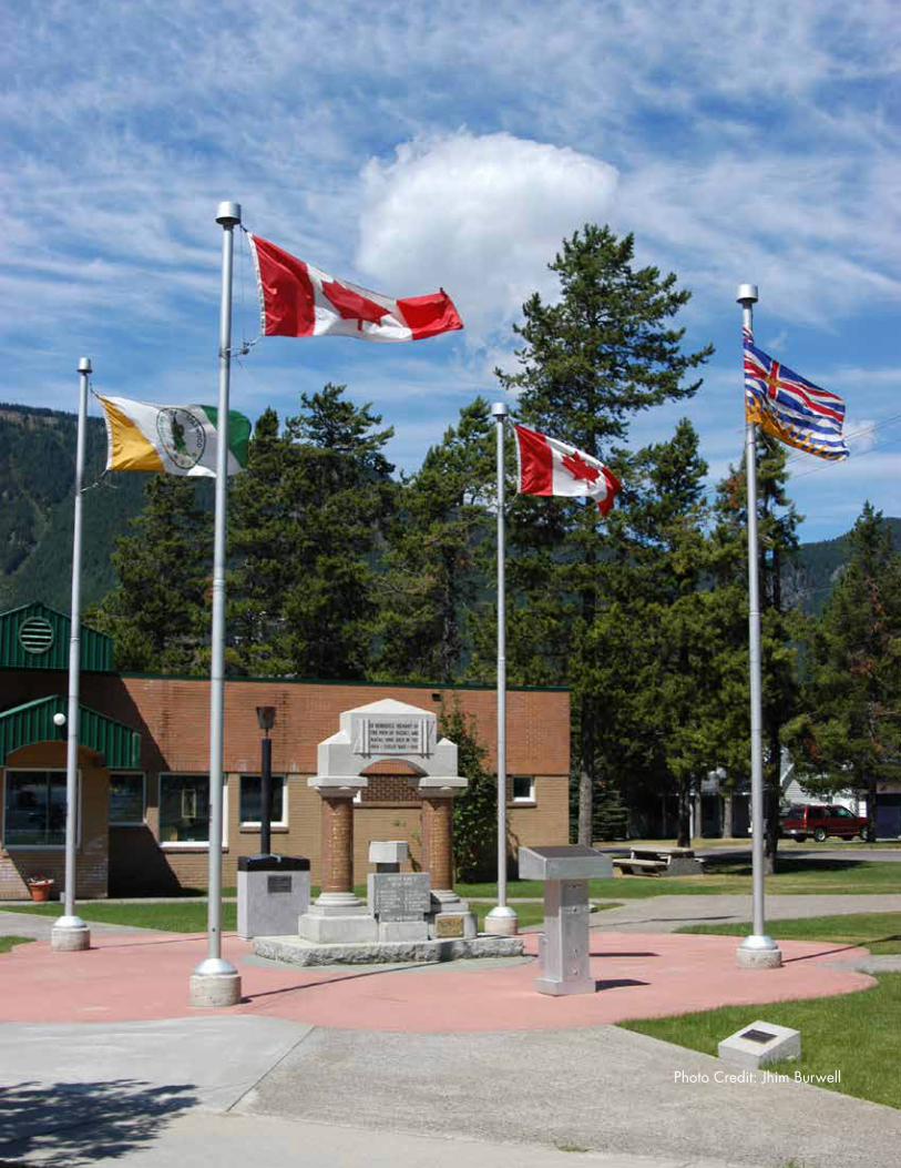
Photo Credit: Jhim Burwell

Introduction 7
2. Purpose and Administration
Purpose of an Official Community PlanThe OCP is a municipal bylaw that sets out the long term vision for a community. Under Section 875 of the Local Government Act, an OCP is a statement of objectives and policies to guide decisions on planning and land use management within the areas covered by the plan.
The Local Government Act requires the OCP to include:
• The approximate location, amount, type, and density of residential development required to meet anticipated housing needs over a period of at least five years;
• The approximate location, amount, and type of present and proposed commercial, industrial, institutional, agricultural, recreational, and public utility land uses;
• The approximate location and area of sand and gravel deposits that are suitable for future sand and gravel extraction;
• Restrictions on the use of land that is subject to hazardous conditions or that is environmentally sensitive to development;
• The approximate location and phasing of major road, sewer and water systems;
• The approximate location and type of present and proposed public facilities, including schools, parks and waste treatment and disposal sites;
• Housing policies of the local government respecting affordable housing, rental housing and special needs housing; and
• Targets for the reduction of greenhouse gas emissions in the area covered by the plan, and policies and actions of the local government proposed with respect to achieving those targets.

8 Our Future Sparwood - District of Sparwood Official Community Plan
An OCP may also include:
• Policies relating to social needs, social well-being, and social development;
• A regional context statement;
• Policies respecting the maintenance and enhancement of farming on land in a farming area or in an area designated for agricultural use in the community plan;
• Policies relating to the preservation, protection, restoration, and enhancement of the natural environment, its ecosystems and biological diversity; and
• Broad objectives in areas not within the jurisdiction of the local government.
Under section 919.1 of the Local Government Act (LGA), local governments may designate areas of land known as a development permit areas (DPA). A DPA can be designated for one or more of the following purposes:
a. protection of the natural environment, its ecosystems and biological diversity;
b. protection of development from hazardous conditions;
c. protection of farming;
d. revitalization of an area in which a commercial use is permitted;
e. establishment of objectives for the form and character of intensive residential development;
f. establishment of objectives for the form and character of commercial, industrial or multi-family residential development;
g. establishment of objectives to promote energy conservation;
h. establishment of objectives to promote water conservation;
i. establishment of objectives to promote the reduction of greenhouse gas emissions.
AdministrationWhile all bylaws enacted or works undertaken by Council after the adoption of an OCP must be consistent with the Plan, amendments may be made to the OCP over time.
Where matters are outside the jurisdiction of Sparwood, this OCP states broad community objectives and “advocacy policies.” These advocacy polices describe how Sparwood can work with other governments, agencies, or organizations to contribute to community objectives. This OCP cannot and does not represent a commitment from other governments, agencies, or organizations to act according to community objectives or advocacy policies.

Introduction 9
Related Planning InitiativesSparwood has undertaken, or participated in, a long list of planning-related initiatives that has informed the development of this Official Community Plan. These include:
• Regional District of East Kootenay Agricultural Plan (2014)
• Elk Valley Regional Economic Opportunity Analysis & Growth Sector Identification (2013)
• District of Sparwood Council Strategic Goals (2013 and 2014)
• Communication Strategy Research Summary Report (2013)
• Review of Selenium in Groundwater (2013)
• Elkford Sparwood Housing Need and Demand Assessment (2012)
• Climate Action Revenue Incentive Public Report (2012)
• Community Energy and Emissions Plan and related energy initiatives (2012)
• Industrial Land Demand Study (2012)
• Carbon Neutral Kootenays Planning to Action (2012)
• District of Sparwood Municipal Building Energy Assessments (2012)
• Water Smart Action Plan (2011)
• Sparwood Transportation Master Plan (2010)
• Elk Valley Agricultural Land Review Project (2009)
• Sparwood Community Sustainability Plan (2009)
• Sparwood Water Source Protection Plan (2008)
• Active Adult Community and Spruce Avenue Feasibility Study (2008)
• Official Community Plan Bylaw 869c, 2002
10 Our Future Sparwood - District of Sparwood Official Community Plan
3. Inter-jurisdictional Planning ContextSparwood consults with neighbouring jurisdictions, agencies and First Nations. Sparwood is located in the asserted traditional territory of the Ktunaxa Nation, which is comprised of four member groups:
• ?Akisq’nuk/Columbia Lake First Nation (near Windermere);
• St. Mary’s First Nation (Cranbrook);
• Tobacco Plains Indian Band (Grasmere); and
• Lower Kootenay Indian Band (Creston).
This OCP focuses on lands under the planning jurisdiction of Sparwood.

Land Use Policies 11
PART II: Land Use Policies

12 Our Future Sparwood - District of Sparwood Official Community Plan
PAGE INTENTIONALLY BLANK

Land Use Policies 13
1. Community Land Use And Growth Management
GOAL 1
Promote compact development and mixed use as the means to achieve a walkable community that provides efficient and sustainable infrastructure, minimizing negative impacts on the environment.
Why is this Important?Growth and change in the community can be managed effectively through policies related to the provision of infrastructure, services, and amenities and through the regulation of land use and development. Promoting compact, mixed-use, and high quality development will help protect our natural areas by reducing urban sprawl, eliminating unnecessary infrastructure spending, and fostering a convenient, walkable, and livable community.
Sparwood TrendsPOPULATION ESTIMATE
Sparwood’s permanent population has fluctuated with the expansion and contraction of industry in the region, but has generally declined since the 1990s.
BC Stats estimated that about 3,800 people lived in Sparwood in 2013, based on an adjustment of the Census to correct for under-counting. Given the high proportion of shift workers, the number of people living in Sparwood is likely higher at any given time, as a result of seasonal, temporary, and commuting workers.
2013 Teck employment information indicates that Sparwood’s experienced population could be as much as 10 to 20 percent higher than reported in the Census. To illustrate, 750 of Teck’s 3,700 employees (20%) lived in Sparwood in 2013. More than 1,600 employees commuted to Teck’s five mines from outside of Sparwood, Fernie, and Elkford. For Elkview, which is the closest mine to Sparwood, over 800 employees live outside of Sparwood. Another dataset supports the fact that Sparwood’s experienced population is higher than the Census. The 2011
1

14 Our Future Sparwood - District of Sparwood Official Community Plan
Census counted 2,760 adults in Sparwood; however, 3,120 tax returns were files filed in 2009 – likely higher in 2011.
Although the number of Teck employees, contractors, and suppliers who commute to or live in Sparwood periodically is unknown, these figures indicate the possibility of Sparwood’s experienced population being as high as 4,200 or more, helping to explain the chronic shortage of rental and hotel accommodations.
Year Permanent Population1991 4,2111996 4,1362001 3,9062006 3,6182011 3,667
POPULATION PROJECTION
Given the historic fluctuation of Sparwood’s population, an estimate of the projected population in Sparwood is challenging. Both a recent study and BC Stats have estimated population growth rates for Sparwood and the Elk Valley, respectively. The estimates range from 0.3% annual growth to a 0.6% annual decline, depending on sources and assumptions used (Figure 3). Considering the long-term population growth trends and demographic analysis from BC Stats, Sparwood’s population is likely to remain steady until 2035, within a range of +/- 0.3% annual growth.
A number of factors affect population projections, such as births, deaths, and migration to and from Sparwood influenced by resource activity. Compared to the Province, Sparwood has, on average, a younger population. However, trends show that the share of Sparwood’s older adults and seniors is increasing. At the same time, approximately 50% of Teck’s workforce will be eligible to retire by 2025. With appropriate housing, healthcare, and services in place, Sparwood could retain retiring workers while attracting new workers.
Although the global market impacts industrial activities, making a 20-year prediction challenging, Teck has announced plans to extend the operations of Line Creek and Elkview operations for about 20 and 30 years, respectively, and to potentially extend Coal Mountain and Fording River. The mine extensions would not likely result in any significant new employment, as workers from closing operations may move into jobs at the extended operations. However, the Environmental Assessment Certificate Application for Line Creek estimates that about 25% of operations employment would come from outside the Elk Valley, indicating a potential to attract new residents to the area.
Figure 2: Sparwood’s Permanent Population 1991 - 2011 (Statistics Canada)

Land Use Policies 15
District’s RoleThrough management of land use and development, Sparwood can accommodate future growth and change in the community. Sparwood may encourage growth and changes in specific areas through modifications to policies, zoning, and incentive programs.
IMPACT OF POPULATION PROJECTION ON RESIDENTIAL SUPPLY
Given the background in “Sparwood Trends,” the population projections in Figure 4 may assist Sparwood in planning, assuming:
• Sparwood’s measured population was 3,800 in 2013;
• The experienced population is closer to 4,200;
• The population will hold relatively steady until 2035 (+/- 0.3% annually);
• The rate of population growth or decline is linear; and
• Economic activity in Sparwood does not change drastically.
Figure 3: Population Projections

16 Our Future Sparwood - District of Sparwood Official Community Plan
Year Low Projection (0.3% decline
annually)
High Projection (0.3% growth
annually)2013 4,200 4,2002015 4,175 4,2252020 4,113 4,2892025 4,051 4,3542030 3,991 4,4192035 3,931 4,486
Water meter and vacancy rate data shows that Sparwood had 2,112 housing units (1103 single and two-family homes, 672 apartments and strata units, and 337 manufactured homes) in 2014.
Looking forward, Sparwood needs more housing suitable for single people and couples with no children (Figure 6). The Districts of Elkford and Sparwood Housing Need and Demand Assessments specifically notes that housing that is affordable (owned and rented) and accessible for seniors is a priority.
Sparwood currently has over 180 vacant single-family lots available in existing residential neighbourhoods for development. Sparwood also has 18 higher-density residential lots available. The roads, water, sewer, and services provided to these approximately 200 lots are already installed.
Development of existing lots is encouraged prior to development of new lands for residential
use.
Figure 4: Population Projection assuming +/- 0.3% annual growth.
Figure 5: Types of Homes (Dwelling Units) in Sparwood (Census 2011)

Land Use Policies 17
Figure 6: Private Households by Household Type (Census 2011)
IMPACT OF POPULATION PROJECTION ON COMMERCIAL AND INDUSTRIAL LANDS SUPPLY
Sparwood currently has 7 commercial, 20 industrial, and 3 agricultural/industrial vacant lots available for development. Developable industrial land is generally 1 to 2.5 acre lots in size.
Sparwood is currently experiencing a shortage of serviced industrial land. The Industrial Land Demand Study recommends offering a supply of 10 to 15 acres in the short term to meet latent demand.
The Industrial Land Demand Study recommends a future demand of land based on historic trends (Figure 7). The lot size, level of servicing, and tenure choice varies by potential use:
• 1 to 1.5 acres, 2 to 3 acres, and 3 acres or larger options
• Buildings sized 1,600 to 10,000 square feet
• Strata, lease, and purchase options
Year Low Forecast (2-3 acres annually)
Medium Forecast (3-6 acres annually)
High Forecast (Up to 10 acres annually)
2025 20 - 30 30 – 60 80 - 100
The Study also recommends that 60-70% of lots be 2.5 to 3 acres if Sparwood feels confident that it can meet the “Medium Forecast” for demand. Otherwise, the Study recommends focusing on 1 and 2 acre lots.
In considering future land supply for commercial and industrial lands, it is important to note that Line Creek and Elkview operations are likely to be extended another 20 and 30 years, respectively (with a similar number of workers compared to current operations), and that Fording River and Coal Mountain operations are also likely to be extended. Section 3: Economic Development contains additional information on employment.
Figure 7: Demand for Industrial Land (Industrial Land Study)
18 Our Future Sparwood - District of Sparwood Official Community Plan
Objectives and Policies
Objective 1.1 To concentrate and mix compatible land uses to enable the cost-effective provision and maintenance of infrastructure over the short, medium, and long term.
Policy 1.1.1 The pattern of proposed land use is shown on the “Future Land Use” map, attached as Schedule B, and reflects the following land use designations:
a) Agricultural;b) Parks and Natural Areas;c) Single-Family Residentiald) Multi-Family Residentiale) Commercial;f) Civic and Institutional;g) Light Industrial; h) Heavy Industrial;i) Extraction Industrial; andj) Private Recreational.
Sparwood recognizes that some existing land uses do not currently conform to the designations shown on Schedule B. The intent is not to change the use of this land in the immediate future, but rather to guide future development and the pattern of land use as development and redevelopment occurs.
Policy 1.1.2 An intended Infill/ Redevelopment Area will be established in the location shown in Schedule C to define areas where increased residential densities are to be encouraged.
Policy 1.1.3 Allow for higher densities and financial development incentives, including revitalization tax exemptions pursuant to S. 226 of the Community Charter, where deemed appropriate in the areas outlined as Intended Infill/ Redevelopment Area in Schedule C. All other areas shall proceed in a logical, sequential order concurrent with availability of required servicing and standard development servicing costs based on the type of use.
Policy 1.1.4 Prioritize the development of existing residential areas over the creation of new residential subdivisions and development on unserviced lands.
Policy 1.1.5 Development applications must comply with the Development Permit Area Guidelines (Part III: Development Permit Areas and Guidelines) with respect to:

Land Use Policies 19
a) Riparian Protection; b) Hazard Lands – for lands over 15% slope and areas within the
200 year floodplain and areas at risk of avalanche; andc) Form and Character.
RESIDENTIAL DEVELOPMENT
Existing residential development in Sparwood consists primarily of single-family dwellings, duplexes, small-scale apartment blocks, townhouses, and mobile homes. The OCP recognizes the unique qualities of each neighbourhood and the opportunity to add suitable infill to use Sparwood’s services and infrastructure resources more efficiently.
Objective 1.2 To accommodate future population growth within the areas identified in the “Future Land Use Map,” attached as Schedule B.
Policy 1.2.1 Encourage the provision of greater housing diversity and affordability by supporting and prioritizing the provision of secondary suites, small lot single family, duplexes, multiplexes, townhouses, and apartments.
Policy 1.2.2 Encourage the development of secondary suites in areas designated as Single Family Residential on the Future Land Use Map (Schedule B).
Policy 1.2.3 Encourage the development of pedestrian and biking trails linking residential neighbourhoods with parks and open space networks, institutional and commercial uses.
Objective 1.3 To allow the integration of different housing forms within the Infill/Redevelopment Areas, as shown on Schedule C to promote neighbourhood diversity and more compact development.
Policy 1.3.1 Encourage the development of a wide variety of residential dwelling types, densities, tenures, and prices to accommodate various age groups, household compositions, incomes, and lifestyles.
Policy 1.3.2 Encourage low-density multi-family residential development to be dispersed throughout the Infill/Redevelopment Area, including duplexes, triplexes, fourplexes, and townhouses where appropriate or can be sensitively integrated.

20 Our Future Sparwood - District of Sparwood Official Community Plan
2. Downtown and Commercial
GOAL 2
Enhance the downtown by promoting high-quality design and construction that reinforces Sparwood’s unique sense of place and become the social, cultural, and economic centre of the community with opportunities to live, work, learn, shop and play.
Why is this Important?A vibrant, prosperous downtown with a mix of services, amenities, and public gathering spaces within close proximity to each other will attract residents and visitors. This concentration of mixed uses will help promote local spending and diversify our economy while creating a community focal point that expresses our proud history and identity. A concentration of activities and housing choices nearby with attractive and accessible buildings and public open spaces will further enhance the downtown as the heart of the community. High-quality design rooted in the local context and based on the community’s natural and human history will help create a unique sense of place and identity for downtown.
Sparwood TrendsIn Sparwood, residents refer to the Centennial Square and Greenwood Mall area by either “uptown” or “downtown,” depending on where they live. For simplicity and consistency, the OCP uses the term “downtown” to refer to this area, and the downtown is identified on “Downtown Map” (Schedule D).
District’s RoleWith the right connections, signage, mix of businesses, activities, and strategic investment in public realm design, the downtown has the potential to become a destination for visitors and a gathering place for the community.
Sparwood supports initiatives that help to create a thriving downtown. The District can:
2
Land Use Policies 21
• Adopt supportive land use and development policies that prioritize and focus appropriate private investments into the downtown including compatible employment, businesses and services;
• Identify and implement strategic public realm investments in the downtown and adjacent areas to support and attract private investments;
• Be a champion for downtown investment and revitalization by marketing and promoting downtown locally and regionally;
• Encourage events and programming to inspire people to visit the downtown; and
• Undertake an integrated downtown urban design plan that sets out a strategic and implementable vision for downtown. The urban design plan should include regulations, tools, and incentives to help attract private investments in the downtown. The urban design plan should identify and illustrate priority public realm improvement projects including partnerships, funding sources, roles, responsibilities, and timelines.
Objectives and Policies
Objective 2.1 To support downtown as a multi-purpose centre, that includes institutional, retail, tourism, and other compatible uses and services.
Objective 2.2 To direct commercial development downtown.
Objective 2.3 To increase the diversity of retail and services downtown.
Objective 2.4 To promote downtown as a unique business centre.
Objective 2.5 To enhance the public realm in the downtown to support commercial objectives and to become the social heart of Sparwood.
Policy 2.5.1 Encourage policies, zoning regulations, and a supply of commercial land that is favourable to attract business to the downtown.
Policy 2.5.2 Encourage professional and business offices and other compatible employment uses to locate downtown.
Policy 2.5.3 Work with existing and potential future employers to locate compatible employment activities in downtown.
Policy 2.5.4 Direct cultural, civic, and compatible institutional uses to the downtown.
Policy 2.5.5 Direct new retail and entertainment uses and services including shops, cafes, restaurants, and grocery stores to the downtown, and discourage these uses
22 Our Future Sparwood - District of Sparwood Official Community Plan
from locating elsewhere in the community.
Policy 2.5.6 Support compact, multi-family, and mixed use housing developments in the downtown to address identified affordable and accessible housing needs in the community and support aging in place.
Policy 2.5.7 Undertake a downtown urban design plan that includes, at a minimum:
a) Priority public realm improvements including upgrades to Centennial Square and adjacent public open spaces, pedestrian and cycling connections, greenery, signage and way finding treatments, and public realm design standards;
b) Design guidelines for private development; and,c) Development tools and incentives to attract and sustain private
investment;
Policy 2.5.8 Sparwood will update its Economic Development Plan to promote and attract commercial and industrial businesses to Sparwood.
Policy 2.5.9 Encourage downtown development, renovations, building improvements, and infill with a Revitalization Tax Exemption Bylaw.
Policy 2.5.10 Build on existing efforts and focus public realm investments in downtown to increase its attractiveness to residents and visitors as a place to work, shop, live, work, learn, shop, and play.
Policy 2.5.11 Work with the community partners to program year-round, family-friendly events, activities, and festivals downtown.
Policy 2.5.12 Lands designated for commercial use on the north side of Spruce Avenue, as shown on Schedule B – Future Land Use, are limited to office or personal service use only. Uses that involve the direct selling of goods, emit odour or noise, or require parking in excess of that provided onsite would not be supported.

Land Use Policies 23
3. Economic Development
GOAL 3
Support a diverse economy that provides a wide range of jobs and services to supplement the mining industry.
Why is this Important?Economic development creates shared wealth and well-being for people and maintains a healthy tax base that supports local services. Economic development aims to achieve this by working in partnership with the private sector, paving the way for inward investment, investing in our people, supporting entrepreneurship, and keeping our locally earned dollars in Sparwood.
Sparwood TrendsMining is the primary economic driver in Sparwood. Teck Coal Limited (Teck) is currently Sparwood’s largest single employer, operating five coal mines and directly employing almost 4,000 workers, 20% of which live in Sparwood. The coal mines in the Elk Valley are the largest producing metallurgical coal mines in Canada. Metallurgical coal is used for steel production and other industrial purposes.
Teck purchases goods and services from local Sparwood businesses to support their mine operations. Information from one mine extension application estimates that each Teck construction job results in 1.4 direct, indirect, and induced jobs, 80% of which are within the Elk Valley (where Sparwood currently comprises 20% of the labour force). The multiplier for operations jobs is 1.7 (Figure 8). Sparwood’s existing businesses include equipment rental, maintenance and repairs, mechanical supply services, construction, trucking and transportation services, professional services (insurance, legal, financial, environmental consulting) and general building supply services. These businesses are currently concentrated in industrially zoned lands in Sparwood. There are also some offices and commercial services located in downtown Sparwood.
3

24 Our Future Sparwood - District of Sparwood Official Community Plan
Direct Employment
Direct Employment to Suppliers
Indirect Employment
Induced Employment
Overall Multiplier
Construction 1 0.7 0.4 0.4 1.4Operations 1 0.8 0.5 0.4 1.7
Economic diversity is a key part of creating a strong local economy. The regional economy is currently one of the least diversified in the province, mining being 28 times more concentrated in the Elk Valley municipalities compared to BC overall. Although communities dependent on single industries can be prosperous, communities that depend on a variety of industries are more resilient and less likely to suffer from the boom-and-bust economic cycle. In the last decade, the percentage of residents employed by mining in Sparwood increased, leading to reduced resilience for our community.
In 2010, over 50% of Sparwood’s population was in the prime working age range of 25 to 54. Industries employing the highest proportion of workers in 2010 included mining (32%), wholesale and retail trade (14%), other services (10%) (includes 4% employment in accommodation and food services), health and education (13%), and manufacturing and construction (8%). Although the share of the prime working age population increased between 2006 and 2011, this prime working age group will decline as workers retire.
Considering jobs in Sparwood and the concentration of specific economic sectors compared to BC overall, economic opportunities include:
• Mining service firms (suppliers);
• New mine development;
• Amenity-driven entrepreneurs;
• Accommodation properties;
• Agricultural processing or value-add development;
• Education and research institutes; and,
• Tourism product development.
There are also opportunities to explore the development of commercial outdoor recreation businesses such as guided fishing, guided rafting, hunting, and tourism related accommodation, beverage, and entertainment businesses, among others.
Sparwood is moving towards becoming a community that attracts and retains residents who work in the industrial sector, as well as a community that offers shops and services suitable for the employment base. With 80% of employees at the five mines living outside of Sparwood, the District has an opportunity to encourage people who live and work in Sparwood, as well as
Figure 8: Estimated Direct, Indirect, and Induced Employment Effects (From Line Creek Operations Phase II Project: Environmental Assessment Certificate Application).

Land Use Policies 25
visitors to carry out their purchasing and business activities within the community. With this in mind, there is currently an opportunity to further develop and broaden the services available to local residents. For example, the Business Retention and Expansion Survey conducted in 2014 highlighted the community’s desire to have further high-quality restaurant options in Sparwood.
District’s RoleSparwood’s Council, staff, and Chamber of Commerce support and promote business development and diversity within the community.
Sparwood supports local economic development through a variety of initiatives, such as:
• Encouraging businesses to locate in the downtown, as identified on Schedule D;
• Working with local business owners to improve aesthetics and make long term improvements to downtown;
• Supporting inter-community business networks in the Elk Valley to encourage business diversity; and
• Dedicating municipal resources to support local business development.
Objectives and Policies
Objective 3.1 To encourage economic diversification and create a supportive climate for businesses.
Policy 3.1.1 Collaborate with the Chamber of Commerce, businesses, and community leaders to develop an economic retention and expansion strategy, aimed at identifying obstacles and opportunities for development in Sparwood.
Policy 3.1.2 Encourage tourism-related businesses and visitor services, including restaurants and retailers, to locate downtown.
Policy 3.1.3 Review policies and zoning regulations to identify opportunities that support mixed commercial and residential uses in the downtown.
Policy 3.1.4 Work with residents, the Chamber of Commerce and Sparwood Visitor Centre to actively promote recreational opportunities in the community.
Policy 3.1.5 Investigate opportunities for increasing the available supply of industrial land to meet the needs of industrial businesses.
Policy 3.1.6 Consider expanding municipal boundary to the north for new industrial land.

26 Our Future Sparwood - District of Sparwood Official Community Plan
Photo Credit: Alex Miller

Land Use Policies 27
Policy 3.1.7 Recognize the opportunity to promote Sparwood as the entrance to BC from the east and build on this opportunity by developing a Heritage Centre downtown.
Policy 3.1.8 Assist developers and employers with their site selection activities.
Policy 3.1.9 Develop a municipal marketing plan or strategy to attract businesses, consumers, and real estate development.
Policy 3.1.10 To encourage the development of local agricultural processing and other value-add operations.
Objective 3.2 To support small business development in the community.
Policy 3.2.1 Recognize home-based businesses as important contributors to the local economy, encouraging them to transition to commercially-zoned lands as their business grows.
Policy 3.2.2 Continue to encourage the development of broadband Internet services in the community as a means to support small business and to attract new businesses.

28 Our Future Sparwood - District of Sparwood Official Community Plan
4. Agriculture and Rural Lands
GOAL 4
Protect, manage and enhance rural, agricultural and forestry lands, balancing competing interests.
Why is this Important?Protecting agricultural land is important to promote long-term food production, employment, and self-sufficiency. Benefits from protecting the forest environment include a healthier environment, ecological biodiversity, and landscape aesthetics. Protecting rural lands helps Sparwood maintain its sense of place, outdoor recreation opportunities, and quality of life.
Sparwood TrendsAgriculture is limited in the Elk Valley due to climate, topography, soil capability, access, and fragmentation of the land into small parcels. Within Sparwood, the majority of agricultural land is comprised of five to ten acre parcels in the Matevic Road area, although there are other small agricultural lands north of Cummings Creek and east of Michel Creek. The primary use of these existing agricultural lands is residential, with little in the way of agriculture production.
Sparwood relies on food industries from other regions, which make it particularly vulnerable from a food security perspective. That is unlikely to change in the future, given the constraints listed in the paragraph above as well as the established global food system in existence today. However, new technology may allow for increased production of marginal land, as would greenhouse farming. Changes to the global food system may also necessitate increasing local food production.
In 2008, the Regional District of East Kootenay (RDEK), in collaboration with the Agricultural Land Commission (ALC), initiated a review of the Agricultural Land Reserve (ALR) boundaries and regulations in the Elk Valley. This work was re-activated through an application initiated by the ALC in 2013, which resulted in a net-loss of ALR lands in this region. Current ALR lands
4

Land Use Policies 29
are designated ‘Agricultural’ in Schedule B: Future Land Use Map.
District’s RoleSparwood manages the development and phasing of rural lands development through this OCP and in accordance with Provincial legislation. Agriculture land in the Agricultural Land Reserve is further regulated under the Agricultural Land Commission Act and Regulations.
Sparwood may encourage local agricultural production through land use regulations, policies, and access to production areas. Sparwood currently accommodates a farmers’ market on District land and could continue to support that initiative in the future.
Objectives and Policies
Objective 4.1 To preserve agricultural land and support farming, where the land capability is well matched for agricultural uses.
Policy 4.1.1 Support the preservation of lands in the Agricultural Land Reserve (ALR).
Objective 4.2 To encourage farming opportunities in Sparwood that match land capability, climatic conditions, and demand for farm products.
Policy 4.2.1 Support farmers’ markets as a means to promote local food production.
Policy 4.2.2 Support the expansion of urban agriculture in the form of community gardens and public produce gardens to creatively and productively use land such as parks and other underutilized green spaces.
Policy 4.2.3 Support food fairs and other food-related public events in the community.
Policy 4.2.4 Support local, healthy and safe food production and distribution through procurement policies.
Policy 4.2.5 Work with local partners and community groups to promote and build awareness of local food security.
Policy 4.2.6 Work with community groups, youth groups, schools and other organizattions to encourage, facilitate, and expand local food production awareness.

30 Our Future Sparwood - District of Sparwood Official Community Plan
5. Culture, Arts and HeritageEncourage, promote and celebrate local heritage, culture and arts.
Why is this Important?Heritage and local mining history play a large role in the character and identity of Sparwood and its residents. Some residents still have strong memories of the former settlements of Michel, Natal, and Middletown that were relocated to Sparwood in the mid-60s. Important events and spaces include the Terex Titan, the mine artifacts walking tour, Miner’s Memorial in Centennial Square, coal mine tours, a museum, and the annual Coal Miner Days event.
Supporting community heritage through arts and culture should:
• Acknowledge and celebrate aboriginal history;
• Help to collectively remember the local history and those communities lost through the urban renewal project in the mid 1960s;
• Support our economy, engage and attract tourism; and,
• Contribute to Sparwood’s unique design objectives for the desired look and feel of the community.
Sparwood TrendsFor more than 10,000 years, the Ktunaxa people (pronounced ‘k-too-nah-ha’), also known as Kootenay, Kootenai or Kutenai, have occupied a traditional territory within the Kootenay region of southeastern British Columbia, and historically included parts of Alberta, Montana, Washington and Idaho. The Ktunaxa language is an isolate, and is unrelated to any other language in the world.
5

Land Use Policies 31
This vast territory of approximately 70,000 square kilometres (27,000 square miles) provided the Ktunaxa people with an abundance of natural bounty. All food, medicine and material for shelter and clothing were obtained from nature. Seasonal migrations occurred throughout the area, from the valley floors to the mountain tops, to follow vegetation and hunting cycles.
The Elk Valley area was the primary home of the easternmost branch of the Ktunaxa people, who are closely connected to families living at what is now Tobacco Plains. For hundreds of generations, the Ktunaxa people used the this area and the Crowsnest Pass as a trade and travel route through the Rocky Mountains.
In 1897 the Crowsnest Coal Company started the area’s first mine, after Canadian Pacific Rail began constructing a rail link between Lethbridge and Kootenay Landing. A year later, the company established the settlement of Michel to house workers. Within two years, Michel grew to twelve cottages, a store, and a hotel. By 1903, just three years later, the population of Michel was over five hundred people. As Michel rapidly grew, other settlements grew in the Michel Valley. Natal was established in 1907. By 1966, the settlements of Michel, Middletown, and the Village of Natal were deemed adversely affected by mining activities, resulting in the relocation of these residents to Sparwood through a provincial urban renewal program. Sparwood was officially incorporated on May 12, 1966. Today, the settlements of these former communities are visible only through commemorative information kiosks at the former town site of Michel. There are no buildings remaining at these former communities.
Arts, culture, heritage, and educational organizations that currently operate in Sparwood include: Michel-Natal-Sparwood Heritage Society, Coal Miner Days Society, and the Sparwood District Arts and Heritage Council.
District’s RoleIn order to encourage local community arts, culture, and heritage initiatives, Sparwood can:
• Use the Community Events Fund to support individuals, groups, and organizations in hosting community events;
• Host events and festivals in partnership with local organizations to showcase various traditions and cultures;
• Display art in public spaces;
• Discourage vandalism through youth education, timely maintenance, and other initiatives that promote civic pride; and
• Collaborate with arts, culture, and heritage organizations on specific projects.

32 Our Future Sparwood - District of Sparwood Official Community Plan
Objectives and Policies
Objective 5.1 To encourage the conservation, interpretation and celebration of the community’s heritage.
Policy 5.1.1 Work with appropriate local groups to maintain heritage displays and signs.
Policy 5.1.2 Develop downtown design guidelines that promote a unique regional expression in architecture and site development.
Policy 5.1.3 To encourage the growth of arts and culture in the community.
Policy 5.1.4 Encourage the development of a public art program to support the work of local artists and enhance public buildings, streetscapes, and other public spaces. Where appropriate, incorporate this public art program in commercial and multi-family developments.
Policy 5.1.5 Identify opportunities to support the arts when making planning, service, and program decisions.
Policy 5.1.6 Establish a reserve fund for the arts to be used for an art component in Sparwood initiated projects.
Objective 5.2 To enhance community facilities and spaces through arts, heritage, and culture.
Policy 5.2.1 As public spaces are developed or redeveloped consider outdoor places that support programmed or spontaneous performance, art installation, and play.
Policy 5.2.2 Consider developing an arts and culture centre that is a welcoming gathering place and is suitable for theatre, performances, art exhibits, and community groups.
Policy 5.2.3 Support cultural, and performing arts uses within the downtown.
Policy 5.2.4 Continue to provide the use of public open spaces for year-round and family-friendly community events and ceremonies, such as street festivals.
Policy 5.2.5 Encourage multi-day community events and festivals, so residents on four-on and four-off schedules can volunteer, attend, and be involved in community gatherings.
Policy 5.2.6 Encourage and work with community and business partners to fund a major public art initiative.

Land Use Policies 33
6. Housing
GOAL 6
Encourage the provision of diverse housing options that allow residents with a range of ages, income levels, and lifestyles to live comfortably in the community through all stages of their lives.
Why is this Important?For most people, housing is the largest single investment they will make in their lifetime. However, people’s needs typically change as they get older – younger singles and couples without children may require smaller homes than families and seniors may wish to downsize to accommodate their changing physical needs. “Housing for all” means that someone’s housing needs can be met throughout their lifetime within the same community, because affordable housing choices exist for varying life stages, situations, and circumstances.
Good housing provides a foundation for a healthy community, offering stability that enables people to work, play, attend school, form relationships, nurture children and participate as citizens. Good housing also affects our local economy, because house prices and rents help determine where new residents choose to move within a region. Areas with high relative housing costs can find it hard to attract and retain service sector workers. Finally, housing can affect our natural environment, depending on how energy efficient we build them and whether the homes are close to shops, services, schools, and jobs.
Sparwood TrendsA range of housing types and tenures can be found in Sparwood including apartments, townhouses, manufactured home parks, single-family housing, and seniors housing.
Rental housing and non-market housing options, such as shelters and subsidized housing, are limited or do not exist in the community. In 2012, 74% of homes in Sparwood were owned and 26% rented. In 2014, Sparwood had 155 apartment units and 69 units for seniors, with an
6

34 Our Future Sparwood - District of Sparwood Official Community Plan
average vacancy rate of 5.4%. In 2013, Sparwood experienced a ten-year low vacancy rate of 3.9% for rental units.
Housing for temporary workers also makes up a portion of the housing stock in Sparwood. As many as 365 homes (18.7%) were occupied by ‘non-permanent’ residents in 2010, representing no change from 2006. This means that non-permanent residents, property investors, or local employers likely own these homes.
The median income in Sparwood is above the provincial average; however, poverty and housing affordability is still a concern. Average housing prices in Sparwood have risen significantly in recent years, as they have across the province as a whole. In Sparwood, housing prices are rising at an average annual rate of 17.6%. This means that housing prices have almost tripled in just 10 years. High current housing prices mean that homes are not affordable for households earning $35,000 or less. In 2010, just under one-in-five households (19%) earned less than $30,000, with 15% spending more than 30% of household income on housing. As many as 90 households paid 50% or more of their income towards housing in 2010.
The Salvation Army is planning a large housing unit to support the region in Cranbrook.
The Districts of Elkford and Sparwood Housing Need and Demand Assessments estimates that 97 to 132 independent and supportive living units, 4 to 6 assisted living units, and 18 to 21 residential long-term care spaces will be required by 2025. Lilac Terrace is expanding the number of housing units and will also provide a palliative care room and a respite room. Interior Health Authority residential long-term care is available in Fernie.
District’s RoleSparwood can:
• Use land use regulations to increase the variety and density of housing types;
• Encourage accessible and VisitAble Housing with no steps at entrances, wide doorways and passages and full amenities on the main floor.
• Locate residential lands within walking distance to amenities and services;
• Either independently or in partnership with other levels of government, develop emergency, transitional, supportive, and assisted housing; and
• Develop an affordable housing strategy.
Objectives and Policies
Objective 6.1 To encourage accessible and VisitAble housing.
Policy 6.1.1 Encourage the development of special needs housing and adult living

Land Use Policies 35
communities in close proximity to downtown. Housing should be compatible with adjoining uses in terms of use, scale, and density, in locations that are in walking distance to amenities and services.
Policy 6.1.2 Explore developing a building checklist or design guidelines that allow for new residential development to accommodate persons with mobility limitations. Considerations include VisitAbility, adaptability, and universal access design.
Objective 6.2 To promote and facilitate the development of market and non-market affordable housing.
Policy 6.2.1 Work with partners such as not-for-profit organizations, housing and community service agencies, businesses, faith community organization, the healthcare sector and others to formulate creative solutions to providing affordable and emergency housing.
Policy 6.2.2 A “housing agreement” may be formed between Sparwood and the owner and registered on the land’s title to protect affordable housing created using incentives or with other municipal resources or programs.
Policy 6.2.3 Advocate to BC Housing to help support low-income households and young family housing needs.
Policy 6.2.4 Consider varying parking requirements or other development incentives for development proposals incorporating non-market affordable housing.
Objective 6.3 To promote safe housing.
Policy 6.3.1 Promote educational material on provincial programs that support landlords and tenants.

36 Our Future Sparwood - District of Sparwood Official Community Plan
7. Community Health and Safety
GOAL 7
Support a healthy, safe and engaged community through social development, community services and civic engagement.
Why is this Important?Ideally, all residents in our community can access quality childcare, education, have adequate living incomes, shelter, and feel safe. Healthy and safe communities meet our basic needs and betters quality of life. A network of holistic and accessible services allows all members of a community to thrive and enjoy a healthy lifestyle.
An engaged and healthy community means that we volunteer, assist each other, and take a role in directing our collective future. Having a strong sense of community matters, because when we cooperate and reciprocate caring, we become a wealthier, healthier, and safer place.
Sparwood TrendsSparwood is observing an increase in the number of retirees and seniors, along with a reduction in young families and young adults living in the community. To support our aging population and to attract and retain new people, Sparwood can work with partners to better serve residents of all ages and abilities.
District’s RoleHEALTH
Sparwood has extensive health services for a small community.
BC Interior Health Authority manages the Sparwood Primary Health Care Centre. Services offered include: physicians, a nurse practitioner, a clinical nurse specialist, support staff, public
7

Land Use Policies 37
health nursing, home care nursing, home support program, a dietitian, a chronic disease management nurse, a chronic care physiotherapist, an acute care physiotherapist, a kidney dialysis clinic, lab and x-ray, addictions counselling for both adults and youth, mental health counselling, and counselling for children who have witnessed violence.
Additionally neurology, pediatrics, hepatology, psychiatry, otolaryngology, obstetrics and gynaecology visiting physicians are available in Fernie. The Elk Valley Hospital is the nearest Level 1 acute care community hospital, also located in Fernie. Regional health care is offered at the East Kootenay Regional Hospital and the Cranbrook Health Unit.
Retention of primary care and emergency health services in Sparwood is important to the community.
EDUCATION
Public education in Sparwood is administered by School District 5. Frank J. Mitchell Elementary School, offering classes from Kindergarten to Grade 6 is recognized for the positive contributions to inclusive education within the province for offering extensive aboriginal support programs and diverse athletic programs. With a current population of 375 students (2015-16) there is a concern for future spacing as enrollment is expected to grow to 400 by 2018. Sparwood Secondary School hosts 300 grade 7 to 12 students in a new facility opened in 2008. The Project Heavy Duty curriculum blends academic studies with hands-on experience in local, industrial and post-secondary opportunities – aiming to keep talent within the community. Graduation rates regularly show in the top 90th percentile in the province.
The College of the Rockies (COTR) is the main post-secondary institution in the East Kootenays, with its main campus in Cranbrook. COTR has partnered with Teck on a Mining Apprenticeship Program that emphasizes skills required for coal mining or electrical operations in the industry.
PUBLIC SAFETY
The Sparwood Fire Department provides fire suppression, motor vehicle extrication, rescue, fire prevention inspections (commercial), and public Fire Prevention & Safety education, as well as other related services within the District of Sparwood. It is a composite volunteer department responding to emergencies from two stations.
Law enforcement and police protection is provided by the Elk Valley Detachment of the Royal Canadian Mounted Police, which is located in Sparwood.
BC Ambulance has one station located within the District of Sparwood.
Sparwood Search and Rescue is a volunteer non-profit organization which operates under guidelines set out by Emergency Management BC. They provide assistance to other agencies by locating and rescuing injured persons in difficult to access locations as well as technical assistance in rope rescue, swift water rescue, flood rescue, avalanche search/rescue/recovery and in response to civil emergencies (i.e. evacuations and floods).

38 Our Future Sparwood - District of Sparwood Official Community Plan
CIVIC ENGAGEMENT
Sparwood promotes volunteer and public engagement activitie using a variety of communications tools so residents can stay informed and get involved in District activities. There are several service organizations in Sparwood including: Society for Kid’s Care Elk Valley, Food Bank Society, Sparwood Futures Society, Lions Club, Knights of Columbus, and Royal Canadian Legion. The Public Relations Committee is a subcommittee of Council that focuses on initiatives to promote the profile of Sparwood. The ongoing engagement of the community is a priority based on the feedback from this Official Community Plan update process.
Objectives and PoliciesHEALTH
Objective 7.1 To encourage a healthy community through social development initiatives.
Policy 7.1.1 Advocate for the BC Interior Health Authority and the provincial government to secure 24-hour emergency care in Sparwood.
Policy 7.1.2 Encourage Interior Health to develop a STARS-accessible helipad.
Policy 7.1.3 Advocate to the Interior Health Authority for an alternative model for continuum of care facilities in Sparwood.
Land Use Policies 39
Policy 7.1.4 Consider adopting a healthy food and beverage policy for civic facilities.
Policy 7.1.5 Consider creating policies to restrict unhealthy food and beverage marketing in public areas frequented by children, including public buildings, the Recreation Centre, parks, and the Public Library.
Objective 7.2 To support increased access to diverse community services for all residents.
Policy 7.2.1 Improve the access and availability of information regarding community services. Support plain language and clear communication, and reach out to new residents to support a welcoming and socially inclusive community.
Policy 7.2.2 Continue to recognize and support the important contributions of volunteers and non-profit groups and agencies, who bring significant value to the community.
Policy 7.2.3 Support the integration of community services such as religious facilities, schools, care centres, group homes and seniors housing into residential areas, where appropriate.
Policy 7.2.4 Continue adopting policies for partial or full property tax exemptions, or other financial incentives, for buildings owned or leased by non-profit organizations to provide social, cultural or recreational services and programs for public benefit.
EDUCATION
Objective 7.3 To support the whole community with skills and trades training and education.
Policy 7.3.1 Encourage the College of the Rockies to develop a Sparwood campus specializing in mining, mechanics, early childhood education, and other disciplines.
Policy 7.3.2 Advocate for access to affordable, quality licensed childcare and preschool, including:
a) Encouraging employer-supported child care; and,b) Encouraging early childhood development initiatives.

40 Our Future Sparwood - District of Sparwood Official Community Plan
PUBLIC SAFETY
Objective 7.4 To create a safe and secure environment for all members of the community.
Policy 7.4.1 Continue using District infrastructure as a crime prevention measure, including lighting improvements, security cameras, beautification, and community clean-ups.
Policy 7.4.2 Consider Crime Prevention Through Environmental Design (CPTED) principles in the review process for rezoning applications.
Policy 7.4.3 Support, recognize, and advocate for public safety volunteers.
Policy 7.4.4 Support the continued operations of Search and Rescue and also provide adequate infrastructure to allow the volunteer organization to provide a high-level of service.
CIVIC ENGAGEMENT
Objective 7.5 To promote a friendly and welcoming community.
Policy 7.5.1 Support a program to welcome and orient new residents and businesses to the community.
Policy 7.5.2 Continue to explore ways to engage and support new residents through Sparwood’s civic engagement processes.
Policy 7.5.3 Where feasible, provide universal physical accessibility in all civic buildings and facilities and promote the same in all other new developments.
Objective 7.6 To actively engage citizens to help inform municipal decision making processes.
Policy 7.6.1 Encourage, engage and partner with community service groups to be responsive in meeting a variety of community needs.
Policy 7.6.2 Implement the Communications Strategy to gather meaningful input into the municipal decision-making process.

Land Use Policies 41
Policy 7.6.3 Apply consistent community consultation protocols for every department for how and when the community will be engaged.
Policy 7.6.4 Establish development engagement guidelines to gather meaningful public input on new developments in the review process.
Policy 7.6.5 Seek creative ways to encourage youth participation in District’s decision-making process.
42 Our Future Sparwood - District of Sparwood Official Community PlanPhoto Credit: Jhim Burwell

Land Use Policies 43
8. Public Utilities and Infrastructure
GOAL 8
Provide and manage infrastructure and services, including potable water, sewage, stormwater and roads, in a cost-effective and sustainable manner.
Why is this Important?All residents and businesses depend on reliable access to safe drinking water, sewage treatment, and stormwater management systems. Providing this infrastructure is one of the largest investments Sparwood makes, and maintenance of these systems is a significant portion of District expenditures.
Sparwood TrendsDRINKING WATER
Sparwood boasts award-winning drinking water. Sparwood maintains 32 km of water pipes. A new reservoir is planned for additional phases Whiskey Jack development. This construction would also involve the installation of new distribution mains.
Sparwood currently operates and maintains three municipal wells to provide the community’s water supply with an additional well planned for construction. The water supply is not chlorinated and water analysis is available at www.sparwood.ca. The existing well pumps have capacity to supply a population of 7,800. Beginning January 2015, Sparwood discontinued fluoridation of its water supply.
Operations and maintenance of Sparwood’s water collection, treatment, and distribution systems are significant and it is important to use the existing system efficiently before requiring costly expansions. Due to the nature of future upgrades to the water system, capital projects must be well planned, so a safe and reliable source of water is provided to best serve the community.
8

44 Our Future Sparwood - District of Sparwood Official Community Plan
Water conservation is an important aspect of extending the lifespan of water treatment and delivery infrastructure. Water conservation policies are contained in Section 11.
SANITARY SEWER AND WASTEWATER TREATMENT
Sparwood’s Sanitary Sewer Wastewater Treatment plant is located at the public works yard and provides secondary treatment through an extended aeration system and oxidation ditch, with ultraviolet as its disinfection system. Waste is separated in a centrifuge process and treated effluent is discharged to the Elk River.
Sparwood maintains 31 km of sewage pipes. A 2005 analysis indicates that Sparwood’s existing wastewater treatment facility has the capacity to service a population of 4,610 people. Given the population projections in Figure 5 (refer to page 16), Sparwood may approach the full capacity of the system by 2035, but is not likely to exceed it. Adding a clarifier and improving the aeration process in the oxidation ditch could increase the plant’s capacity to support a population of 8,170.
Sparwood has invested in a water loss management and water conservation program to reduce load entering the treatment plant and to extend the lifespan of the treatment facility. In 2015, Sparwood be initiated an infiltration program to locate leaks into the wastewater system.
The Sparwood Heights Lift Station is located on Lower Matevic Road. The station currently services all of Sparwood Heights and has the capacity to service a population of 4,540 people. To accommodate the Whiskey Jack development, plans exist to upgrade the force main. While Sparwood Heights and Whiskey Jack could approach a fully built out population of 5,170, the population projections in Figure 5 (refer to page 16) suggest that this population is not likely to be reached by 2035.
OTHER INFRASTRUCTURE
Sparwood maintains 17 km of stormwater pipes. The transfer station is located in south Sparwood and operated by the RDEK. Electricity is provided by BC Hydro, natural gas by Fortis BC, and telecommunications by Telus and Shaw.
Sparwood has constructed the open access underground fibre optic network and currently provides 100 megabit full-duplex service over single-mode optical fibres. The backbone runs approximately 4.5 km from the Municipal Office’s Networks Operation Centre down Spruce Avenue, over to and down Pine Avenue to the end of Douglas Fir Road.
District’s RoleSparwood, the RDEK, the Provincial and Federal Governments all provide services to people in Sparwood. Sparwood provides water, sewer, stormwater, street lighting, fire, and garbage collection services. Investment in a fibre optic network in the early 2000s has provided Sparwood with a strong communications infrastructure and the potential to expand business and education services.

Land Use Policies 45
Objectives and PoliciesMUNICIPAL INFRASTRUCTURE
Objective 8.1 To provide utility services in an orderly pattern of development to avoid premature expenditures on municipal infrastructure.
Policy 8.1.1 The extent, location and phasing of development for infrastructure, including municipal water and sanitary sewer trunk lines, are shown in Schedule F and Schedule G.
Policy 8.1.2 Sparwood does not support the extension of municipal services outside its municipal boundary.
Policy 8.1.3 Update the Subdivision Servicing Bylaw 591 to allow for environmentally sustainable alternatives that reduce infrastructure, operations, and maintenance costs and make Sparwood more resilient to climate change. An update should also consider sustainable options for stormwater management, low water use landscaping, dark sky standards, and standards appropriate to match winter conditions.
Policy 8.1.4 Update the Subdivision Servicing Bylaw 591 to include integrated stormwater management. A combination of storm sewers, groundwater recharge, detention ponds, wetlands, ditches and natural drainable courses should be considered to accommodate stormwater runoff and mitigate negative impacts on downstream areas and watercourses.
Policy 8.1.5 Sparwood encourages private enterprise and developers acting as the prime applicants for future subdivision, land development, and land sales. Sparwood wishes to reduce, and eventually eliminate, its historic role in land development.
Objective 8.2 To require that the costs of upgrading infrastructure services and servicing new development be borne by those who benefit.
Policy 8.2.1 When feasible, Sparwood will enter into latecomer agreements to require benefiting parcels to pay their proportionate share of infrastructure costs when connecting to the excess or extended service.
Policy 8.2.2 Sparwood supports the principle of infrastructure improvements that benefit the municipality as a whole. Where possible, provincial cost sharing will be sought to reduce the financial impact on the ratepayer.

46 Our Future Sparwood - District of Sparwood Official Community Plan
Policy 8.2.3 The costs of upgrading services are borne primarily by those property owners who benefit including local service areas, utility charges, development works service agreements, and other finance tools.
Policy 8.2.4 New development will continue to contribute toward the costs of infrastructure capacity improvements that benefit the entire community through the use of development works servicing agreements, amenity negotiations, comprehensive development agreements, and other finance tools.
Objective 8.3 To encourage infrastructure systems that addresses energy conservation.
Policy 8.3.1 Promote demand-side management programs by working in partnership with BC Hydro, natural gas providers, and provincial and federal programs.
Policy 8.3.2 Leading by example, continue energy conservation initiatives using Sparwood’s assets, including LED street lighting and District building retrofits.
WATER INFRASTRUCTURE
Objective 8.4 To provide a sufficient supply of water to serve the domestic, fire protection, and irrigation needs of the community.
Policy 8.4.1 Continue Sparwood’s water system maintenance and upgrades through the Water Loss Management Program aimed at identifying and repairing leaks to watermains.
Policy 8.4.2 Integrate ongoing water conservation measures into water system planning.
Objective 8.5 To protect surface and groundwater supply sources in the community.
Policy 8.5.1 Focus investment in the development and rehabilitation of water system elements identified in Infrastructure Map – Water Phasing (Schedule F).
Policy 8.5.2 Continue the Source Water Protection program where municipal wells are protected by designated Groundwater Protection Zones which limit recreational, commercial and agricultural use of the surrounding land.
SANITARY SEWER INFRASTRUCTURE
Objective 8.6 To provide sufficient capacity for municipal sanitary sewer collection system and treatment facilities.
Policy 8.6.1 Extend the life and functionality of the wastewater treatment plant by reducing load, which may include addressing issues relating to inflow, infiltration, and

Land Use Policies 47
excessive water consumption.
Policy 8.6.2 Investigate options for wastewater treatment to meet future demand, including plant upgrades, expansion or replacement.
Policy 8.6.3 Invest in the development of the sewer system elements identified in Infrastructure Map – Sewer Phasing (Schedule G).
STORMWATER MANAGEMENT
Objective 8.7 To prevent adverse effects to the water quality of creeks, streams, rivers, and other bodies of water that may receive stormwater discharge.
Policy 8.7.1 Encourage new development to incorporate Stormwater Management Best Practices that are appropriate for the site condition.
Policy 8.7.2 Prepare a Stormwater Management Master Plan for the community to reduce negative impacts from direct discharge into rivers, creeks, and streams.
Policy 8.7.3 Identify drainage basins, necessary infrastructure improvements, capital costs, and environmental protection requirements.
Policy 8.7.4 Encourage the use of parks and open space for stormwater detention areas and conveyance corridors where space and programs permit.
Policy 8.7.5 Encourage the use of surface drainage systems as an amenity or open space corridors.
Policy 8.7.6 Encourage the use of natural systems, like wetlands to capture, slow down, store, filter and infiltrate stormwater discharge in existing and new development where such systems are designed by a qualified professional with expertise in this field.

48 Our Future Sparwood - District of Sparwood Official Community Plan
9. Transportation, Highway and Utility Corridors
GOAL 9
Provide a safe and efficient multi-modal transportation system that balances vehicular traffic with active transportation.
Why is this Important?Sparwood’s transportation network provides internal linkages for residents, regional links for residents and workers, and connects Sparwood economically to the world.
Sparwood is the first community encountered while traveling from Alberta to British Columbia on Highway 3. The highways are important corridors for the movement of goods, creating critical economic linkages to support local businesses and providing visitors with the first impression of the community along with services to travelers.
Internal and regional links are important for connecting residents and workers to jobs, shops, services, healthcare, and education. A strong transportation network provides people with safe, accessible, and convenient travel choices. Community health and well-being can be improved by making active and shared transportation (walking, cycling, shuttles, and buses) an easier and more attractive choice for people of all ages, abilities, and incomes. Transportation choices can also help mitigate safety risks from impaired driving.
Sparwood TrendsSparwood is accessible by air, road, and rail. While it looks different today compared to the late 1800s, the Canadian Pacific Railway still provides a key link to export Sparwood’s resources to coastal ports. The existing five Elk Valley coal mines depend on rail to transport coal – 90% of which is shipped west to Vancouver ports for transport to world markets.
The local Elk Valley Airport supports a small charter service while the Canadian Rockies
9 Photo Credit: John Baker

Land Use Policies 49
International Airport, near Cranbrook, and the Calgary International Airport offer commercial and freight service.
The Elk Valley Transit System provides a public transit connection between Elkford, Sparwood and Fernie while the Health Connections bus connects Sparwood to Cranbrook with service to the Elk Valley Hospital in Fernie. Funding for the transit service is shared by the RDEK and BC Transit.
District’s RoleSparwood’s roads, sidewalks and trails are an important public asset that facilitates vehicle, bike and pedestrian movement between different parts of the community. The performance of a transportation network affects quality of life, economic activity, and social well-being in the community.
The Iron Rails CPR Overpass, Elk River Crossing Pedestrian Bridge, and the Link Trail that connect Sparwood Heights to Lower Sparwood were officially opened in 2011. A 5.1 km vehicular route can now be replaced by 1.6 km of walking or cycling. The investment in these pedestrian linkages has greatly improved the walkability between Sparwood Heights and Lower Sparwood and provides an emergency route to Sparwood Heights in case the highway is closed. Plans exist to add more trails to connect residential areas to the downtown. The overpasses and trails also serve an important safety function by providing safe access over the railway tracks.
Objectives and PoliciesTRANSPORTATION NETWORK
Objective 9.1 To provide for the efficient and safe movement of people and goods.
Policy 9.1.1 Work with other levels of government, including the Ministry of Transportation and Infrastructure, in the planning, design, and construction of all regional roadway projects to develop efficient and safe transportation networks. Transportation includes consideration of all modes including vehicles, pedestrian, bicycle, and commercial trucks.
Policy 9.1.2 For proposed residential, commercial, and industrial developments, the District of Sparwood and the Ministry of Transportation and Infrastructure will facilitate and administer coordinated Traffic Impact Assessments to address changes in traffic movements, volumes and any associated road infrastructure requirement.
Policy 9.1.3 Consider wildlife migration in the development of transportation networks.
50 Our Future Sparwood - District of Sparwood Official Community Plan
Objective 9.2 To provide multiple modes of transportation that link all land uses and build on Sparwood’s trail network and path system as a means to reduce vehicle trips.
Policy 9.2.1 Work with the Ministry of Transportation and Infrastructure, major employers and development partners to prioritize the implementation of objectives contained in the Sparwood Transportation Master Plan.
Policy 9.2.2 Work with the Ministry of Transportation and Infrastructure and major employers to provide multi-modal access, connections, streetscape improvements, and landscaping associated with the future development of office and commercial services east of the Highway 3 and Highway 43 intersection.
Policy 9.2.3 Continue to upgrade and develop existing and proposed trails as set out in Schedule H: Parks and Natural Areas.
Objective 9.3 To upgrade and expand the transportation network in an environmentally sensitive and fiscally responsible manner.
Policy 9.3.1 Gradually build pathway connections, upgrades, and on-street facilities that accommodate cyclists and other active-mode users, as outlined in the Transportation Master Plan.
Policy 9.3.2 Consider reducing the parking requirements for develpments where alternative transportation means are provided, for example, car-share programs.
Policy 9.3.3 Evaluate transportation investments using a transportation hierarchy that values active transportation, freight movement, and personal vehicles in decreasing order of importance.
Objective 9.4 To improve the safety, comfort, and appearance of sidewalks.
Policy 9.4.1 Streetscape improvements, including landscaping, consistent street furnishings, sidewalk construction and replacement, shall be considered in all road upgrade projects.
Policy 9.4.2 Support sidewalk improvements that will result in increased pedestrian safety and mobility throughout the community.

Land Use Policies 51
Objective 9.5 To enhance the aesthetic quality of the highway corridor area.
Policy 9.5.1 Work with the Ministry of Transportation and Infrastructure to ensure access management principles and major street network plans are considered when reviewing development along Highway 3 and Highway 43.
Policy 9.5.2 Work with the RDEK and the Ministry of Transportation and Infrastructure to continue efforts in reducing sign clutter along Highways 3 and 43.
Policy 9.5.3 Continue to support the Gateway Business Signage Program and discourage new signage along highway corridors, except as permitted by the Sign Bylaw.
ACTIVE TRANSPORTATION
Objective 9.6 To increase local transportation options between homes, jobs, shops, and services.
Policy 9.6.1 Construct paths and trails networks in accordance with Schedule H: Parks and Natural Areas.
Policy 9.6.2 Continue to work on infrastructure projects that support walking, bicycling, and other active modes as alternative forms of transportation.
Policy 9.6.3 Link walking and cycling paths and lanes to adjacent major open spaces, parks, schools, other public institutions, and large activity areas.
Policy 9.6.4 Require new developments in the community, where practical, to provide walking/biking path connections to the community’s trail network.
Policy 9.6.5 Address, where practical, mobility concerns and barrier-free access issues during the design and construction of trails.
Policy 9.6.6 Encourage bicycle travel through the provision of facilities such as bike racks at public recreation facilities, in parks, commercial areas, and at schools.
Policy 9.6.7 Seek cooperation in the future joint-use of utility and transportation corridors as cycling and pedestrian networks and endeavour to incorporate any abandoned corridors as part of the community’s trail network.

52 Our Future Sparwood - District of Sparwood Official Community Plan
PUBLIC TRANSPORTATION
Objective 9.7 To increase regional transportation options between homes, jobs, shops, and services.
Policy 9.7.1 Work with BC Transit, RDEK, and other local governments in the area to meet the public transit needs of Elk Valley residents.
Policy 9.7.2 Work with major employers and the Chamber of Commerce to determine if there is a need for a shuttle service between Sparwood and primary work sites.
Policy 9.7.3 Encourage the development of volunteer shuttle services.
RAILWAY CORRIDOR
The railway rights-of-ways through Sparwood have been designated as Transportation use on the Future Land Use Map (Schedule B).
Objective 9.8 To preserve Transportation Corridors for transportation uses.
Policy 9.8.1 Allow rail transportation use in the existing railway rights-of-way.
10

Land Use Policies 53
10. Parks and Natural Areas
GOAL 10
Encourage an active and healthy community through the development, maintenance and enhancement of high-quality parks, passive and active recreational facilities and programs, and active transportation infrastructure.
Why is this Important?Parks and green space offer refuge and direct access to nature in an otherwise built environment. Quality green space and park areas provide for a variety of recreation, leisure and social opportunities for the community. A key contributor to the quality of life is the significant extent of parks and open space in the community and the linkages offered by trails to between communities and surrounding natural area.
Recreation engages people and builds social cohesion, generating healthy and inclusive communities. Recreation and leisure is essential to our well-being, encouraging physical activity, fostering social connections and providing enjoyment for all ages and abilities.
Sparwood TrendsOutdoor recreation is a key activity in Sparwood for both residents and tourists. Trail systems and old forest service roads provide access for hiking, camping, mountain biking, and motorized pursuits. Mountain rivers, streams, Summit and nearby Grave Lake provide opportunities for boating, fishing, and swimming. Wildlife viewing and hunting are also popular due to the large amount of game in the area, such as bear, cougars, deer, elk, moose mountain goat and bighorn sheep.
In addition to the abundant outdoor recreation amenities, Sparwood’s recreation facilities include a large leisure centre with a pool, fitness centre, skating arena, curling rink, dance studio/multi-purpose room, climbing wall and indoor racquet courts. Outdoor facilities include playgrounds, skate park, bike park, minor and regulation ball diamonds, multi-purpose sports
10

54 Our Future Sparwood - District of Sparwood Official Community Plan
field, track, and disc golf course. Sparwood offers a variety of leisure programming for children and adults throughout the year.
The Sunset Ridge Ski Society maintains several kilometers of cross-country ski trails in the winter. In summer, there is a nine-hole golf course and driving range, operated by the Sparwood Golf Club. In addition to that, the developers of the Whiskey Jack subdivision have begun construction of an 18-hole golf course.
Emerging trends and issues in recreation and leisure include: Aging infrastructure; Changes in demographics; Changes to sport standards and regulations; New standards for health, safety and the environment; Increased need for accessibility; and, Changing trends in recreation choices.
District’s RoleSparwood has built numerous parks, playgrounds, sports fields, and pedestrian linkages that supplement the natural recreation amenities in Sparwood. Continued investment in these facilities and programs will help provide for the recreational needs of residents.
Sparwood recognizes the existing parks, trails and recreation areas shown on the “Parks and Natural Areas” map (Schedule H).
Objectives and Policies
Objective 10.1 To meet the park and recreational needs of residents.
Policy 10.1.1 In accordance with S. 941 of the Local Government Act, Sparwood will require dedication of land, including linear pars as trails, in accordance with the “Parks and Natural Areas” map (Schedule H), or cash in lieu of park dedication. Proposed dedications of park lands that are isolated and do not add to parks and trails connectivity will be discouraged.
Policy 10.1.2 Pursuant to S. 941 (2) of the LGA, in the event that the area shown on the “Parks and Natural Areas” map (Schedule H) is less than 5% of the area proposed to be subdivided, at the option of the District of Sparwood, the District of Sparwood may require cash in lieu pursuant to S. 941(1) of the LGA, or land of up to 5% of the area proposed to be subdivided.
Policy 10.1.3 Promote a range of affordable recreational programming.
Policy 10.1.4 Seek input from youth in the community in identifying facilities and programs that meet their needs.
Policy 10.1.5 Update the Parks and Recreation Master Plan to guide the development

Land Use Policies 55
Photo Credit: Marija Goetting

56 Our Future Sparwood - District of Sparwood Official Community Plan
of recreation facilities, and priorities for the improvement of parks, trails, pathways, and open space.
Policy 10.1.6 Integrate park planning and design with broader community planning initiatives related to land use, residential development, transportation, and provisioning of community amenities, including:
a) Public gathering places for community celebration, contemplation, meeting socially, and for civic engagement;
b) Public art; andc) Aboriginal and immigrant culture, the environment, local heritage
and veterans.
Policy 10.1.7 Encourage partnerships with community groups to expand Sparwood’s park use and implement diverse programming within parks that benefit local residents.
Objective 10.2 To use green corridors effectively to promote healthy living and provide more opportunities for walking and biking.
Policy 10.2.1 Continue to expand the paths and trail system over time by adding links to residential subdivisions and by connecting them to schools, recreation facilities, parks, and downtown.
Policy 10.2.2 At the time of subdivision, seek opportunities for connecting public access trails and/or parks. The access corridor may be in addition to, and outside, any riparian management area requirements identified in this OCP.
Policy 10.2.3 Sparwood may consider the acquisition of all or a portion of properties in high-priority access areas where it is unlikely the required land can be obtained in less expensive ways in the desired timeframe.
Policy 10.2.4 Encourage partnerships with private landowners, agencies and community groups to create opportunities for expanding trails and linear parks within the town and on surrounding Crown Lands.
Policy 10.2.5 Encourage partnerships and opportunities for expanding back-country ridge trail circuits and access to lookouts aimed at hiking, mountain biking, cross-country skiing, back-country skiing, and snowshoeing.
Policy 10.2.6 Work with the RDEK and motorized recreation groups for the identification of off-road recreation areas.

Land Use Policies 57
Policy 10.2.7 Consider securing public access along the south side of Cummings Creek for the purpose of constructing a non-motorized trail linking the cross-country ski trails on the west end to the proposed trail next to Hwy 43 in the absence of a developed golf course by October 2017
Policy 10.2.8 Consider securing public access along the south side of Cummings Creek for the purpose of constructing a non-motorized trail linking the proposed trail along Hwy 43 through to the future park lands at the confluence of Cummings Creek and the Elk River
Policy 10.2.9
Policy 10.2.10

58 Our Future Sparwood - District of Sparwood Official Community Plan
11. Environmental Protection and Open Space
GOAL 11
Promote environmental conservation best practices.
Why is this Important?
Within the Elk River Valley, Sparwood is blessed with a beautiful montane grassland, watercourses, and forest environment that supports a vast array of fish and wildlife.
We cannot live without a properly functioning ecosystem. Plants, animals, and fungi clean our air, moderate our climate, provide us with food, absorb our wastes, and provide numerous other ecological, aesthetic, and social benefits.
Sparwood TrendsWith 6,000 to 12,000 vehicles a day traversing Highway 3, the rate of wildlife-vehicle collisions has raised public safety concerns. Research in 2010 identified that the section of Highway 3 between Sparwood and Hosmer is a high priority for addressing wildlife safety concerns, due to the migratory paths of large animals and a pilot program is being installed by the Ministry of Transportation and Infrastructure.
Between 2009 to 2012, water demand increased by four percent, due to system leaks. As a result of finding and fixing these leaks, Sparwood has achieved a total decrease in gross demand from 2009 of 12%, as of the end of 2014. In the summer months of July and August, water consumption nearly doubles in the community due to watering of lawns and gardens.
Water conservation initiatives are aimed at using water resources wisely, particularly in the peak summer months, and at delaying the need for costly infrastructure improvements. Starting in 2012, Sparwood participated in the Columbia Basin Trust Water Smart Initiative and
11

Land Use Policies 59
Ambassador program to provide education and incentives for water consumers to reduce water use demands.
The Regional District of East Kootenay operates a transfer station at the south end of Sparwood and recycling drop-off locations within the community. Acting on opportunities to divert and reduce waste is a desirable objective for Sparwood and the Regional District.
There are three coal mines within Sparwood’s boundary with one being visible from the centre of the community. The air and water quality are monitored by the mines and regulated by the Ministry of Environment (Provincial) and Fisheries and Oceans Canada (Federal). Environmental organizations currently working in Sparwood include Nature Conservancy of Canada, the BC Wildlife Federation – Region 4E: East Kootenay, Wildsight, Elk River Alliance, and the Sparwood and District Fish and Wildlife Association.
District’s RoleSparwood covers 17770 hectares which includes a variety of mountains, rivers, woodlands, and open green spaces.
To support a healthy natural environment Sparwood has implemented:
• A pine beetle forest management and replanting program;
• A reforestation plan for previously unforested areas; and
• A landscape restoration plan for forested areas.
Sparwood is at the confluence of the Elk River and Michel Creek and surrounded by mountain ridges. These mountains and watercourses are natural environmental features that significantly shape the physical development of this valley community. It is important to establish policies that will serve to protect and enhance environmentally sensitive areas; for example, to consider the potential negative impacts of recreational and other activities on environmentally sensitive areas. The community recognizes that it must play a role in the stewardship of these natural features in order to preserve the community’s assets for present and future generations.
Numerous programs for water conservation and protection, energy efficiency, and general sustainability have also been initiated or are being investigated.
Objectives and PoliciesWILDLIFE AND HABITAT PROTECTION
Objective 11.1 To protect the natural environment, ecosystems and biological diversity.
Policy 11.1.1 Develop guidelines to mitigate the loss of wetlands, wildlife habitat and indigenous vegetation areas.

60 Our Future Sparwood - District of Sparwood Official Community Plan
Policy 11.1.2 Continue to work with the RDEK to manage invasive and noxious weeds.
Objective 11.2 To identify and protect wildlife corridors and wildlife habitat areas from potentially negative impacts of land development.
Policy 11.2.1 Work with local environmental organizations, RDEK, and relevant provincial and federal government ministries to establish a Wildlife Corridor Identification and Protection Strategy for the area.
Policy 11.2.2 Consider the implementation of wildlife programs to reduce conflict between wildlife and human populations.
Policy 11.2.3 Investigate replacing or retrofitting existing solid waste disposal containers with wildlife resistant containers.
WATERSHED PROTECTION
Objective 11.3 To protect fish-bearing watercourses from negative impacts.
Policy 11.3.1 Protect environmentally sensitive riparian areas using one or more of the following measures, depending on which best suits the given situation:
a) Dedication as a park or trail where the area compliments the goals and objectives of Sparwood’s Parks and Trails Master Plan;
b) Dedication to a land trust or similar non-government organization for conservation purposes; and
c) Covenant for conservation purposes with Sparwood, the Province of British Columbia, and/or a non-governmental organization(s) eligible to hold conservation covenants.
Objective 11.4 To maintain and enhance surface and groundwater quality in area watercourses.
Policy 11.4.1 Partner to support or conduct assessments and inventories of aquatic and terrestrial ecosystems related for the purposes of updating protection strategies, restoration programs, and facilitating appropriate land use and servicing decisions.
Policy 11.4.2 A corridor of land along lakes, rivers, creeks, and tributaries is designated as a Riparian Protection Development Permit Area – Part III of this OCP. The Riparian Protection Development Permit Areas are defined in Schedule I.
Policy 11.4.3 Encourage, where appropriate, the use of wetlands for stormwater detention or retention purposes.
Land Use Policies 61
PROPERTY AND LIFE PROTECTION FROM DEVELOPMENT IN HAZARDOUS AREAS
Objective 11.5 To identify and protect areas subject to hazardous conditions.
Policy 11.5.1 Expand the knowledge base of hazardous conditions that exist in Sparwood as a means of improving land use and servicing decisions.
Policy 11.5.2 Lands with slopes greater than 15% and subject to avalanche hazard or are within mapped 1:200 year floodplain areas are designated as Hazard Development Permit Area, as defined in Schedules J, K, and L. The areas and guidelines are established to protect real and personal property and life in hazardous land areas – see Part III of this OCP.
AIR QUALITY PROTECTION
Objective 11.6 To improve air quality.
Policy 11.6.1 Collaborate with RDEK, Elk Valley municipalities and major employers, to address issues that affect air quality in the Elk Valley.
Policy 11.6.2 Encourage large employers and government agencies with air quality monitoring data to share this information with the community.
Policy 11.6.3 Investigate educational and outreach programs about proper wood stove use, including a wood stove exchange program.
WATER CONSERVATION
Objective 11.7 To reduce demand on Sparwood’s municipal water infrastructure by encouraging appropriate water conservation measures.
Policy 11.7.1 Actively promote, coordinate and implement water conservation practices in the community.
Policy 11.7.2 Continue and complete the program of installing universal water metering as a means to reduce water consumption and to enable a user-pay approach for water utility financing.
Policy 11.7.3 Support water conservation across all major water customer sectors through implementation of conservation measures such as pricing and other financial incentives, education, and consideration of future regulations.
Policy 11.7.4 Expand upon the Water Smart Initiative, where monitoring results indicate cost-benefit of water conservation tools and practices and demonstrate

62 Our Future Sparwood - District of Sparwood Official Community Plan
leadership to property owners by assessing and retrofitting new and existing municipal buildings to maximize indoor water efficiently.
Policy 11.7.5 Encourage property owners to incorporate xeriscaping or drought resistant planting concepts into development of landscape plans.
Policy 11.7.6 Demonstrate leadership by developing xeriscape or low water demand landscaping for District lands and facilities, such as medians, islands, boulevards, and parks to conserve water, while undertaking proper maintenance and function.
SOLID WASTE MANAGEMENT
Objective 11.8 To provide adequate solid waste management services for Sparwood residents.
Policy 11.8.1 Work with RDEK to implement the Regional Solid Waste Management Plan.
Policy 11.8.2 Work with RDEK to develop a program that promotes the benefits of the 5 R’s: Reuse, Reduce, Recycle, Recover and Residual Management.
Policy 11.8.3 Consider the provision of a community composting program.
Objective 11.9 To encourage various forms of recycling as a means to reduce waste produced in the community, to extend the life of existing regional landfills, and reduce negative impacts on the environment.
Policy 11.9.1 Work with the RDEK to encourage and promote the existing recycling system and expand where possible.
Policy 11.9.2 Work with RDEK to encourage and promote provincial recycling initiatives, including those directed toward the recycling of beverage containers, tires over 630mm in diameter, household batteries, used motor oil, paint, and electronic wastes, by providing appropriate collection facilities at Sparwood’s transfer station.
Policy 11.9.3 Work with RDEK to determine the feasibility of diverting reusable materials to reduce waste sent to regional landfills. This process may include a possibility of granting salvage rights to individuals or organizations.
Policy 11.9.4 Consider the provision of recycling containers alongside publicly provided waste disposal containers in community parks, recreation centres, and in the downtown area as a means to encourage recycling and to reinforce

Land Use Policies 63
Sparwood’s desire to be an environmentally-conscious community.
REDUCTION OF GREENHOUSE GAS EMISSIONS
Through the Local Government (Green Communities) Statutes Amendment Act, also known as Bill 27, local governments are required to include targets, policies, and actions towards reducing greenhouse gas emissions from their communities in their OCP. In 2012, Sparwood completed a Community Energy and Emission Plan with actions that are being implemented in areas of building performance, transportation, and infrastructure.
Objective 11.10 To reduce community greenhouse gas emissions by 2 tonnes per capita from 2007 baseline levels by the year 2020.
Policy 11.10.1 Develop a sustainability checklist for buildings to improve energy efficiency in new and existing construction.
Policy 11.10.2 Encourage active transportation through infrastructure development and education.
Policy 11.10.3 Work with BC Transit to support and improve public transit.
Policy 11.10.4 Work with utility companies to promote energy conservation.
Policy 11.10.5 Implement the recommendations contained in the Municipal Energy Assessments, where feasible and cost-effective.
Policy 11.10.6 Incorporate energy efficient standards into purchase agreements, enforced through a Section 219 covenant, when selling District lands for development.
Policy 11.10.7 Encourage the continued implementation of LED street lighting, solar pathway lighting and lighting retrofits in municipal buildings where appropriate.
Policy 11.10.8 Work with major industries to seek opportunities for heat recovery and energy production.
Policy 11.10.9 Review and implement Sparwood’s purchasing policies to include carbon footprint considerations in the bid tendering process when purchasing products and services.
64 Our Future Sparwood - District of Sparwood Official Community Plan

Land Use Policies 65
12. Sand and Gravel Resource Extraction
GOAL 12
Protect sand and gravel resource extraction areas in the community.
Why is this Important?The Local Government Act requires that an OCP identify areas of sand and gravel resource extraction in the community. The BC Ministry of Energy and Mines data shows three sand and gravel pits and two quarries located nearby in RDEK.
Sparwood TrendsTo date, gravel has been taken out of a site south of Hwy 3, the Whiskey Jack area, and across Highway 43 from Sparwood Heights Drive. No sources of sand and gravel suitable for commercial extraction have been identified within Sparwood’s boundaries. The nearest sand and gravel deposit is the Sparwood Quarries, located west of Sparwood in the Cummings Creek watershed.
District’s RoleSparwood is responsible for identifying the supply of sand and gravel deposits that can be extracted in the future.
Objectives and Policies
Objective 12.1 To recognize the approximate location and area of sand and gravel deposits suitable for future extraction.
Policy 12.1.1 Complete a Sand and Gravel Resources Study to identify future sources of sand and gravel for the community.
12

66 Our Future Sparwood - District of Sparwood Official Community Plan
13. Temporary Use Permit Area
GOAL 13
Provide flexibility in land use to promote business development and diversification.
Why is this Important?In accordance with the Local Government Act (Sections 879 and 921), an Official Community Plan may designate areas where Council may consider allowing temporary uses and may specify general conditions regarding the issuance of temporary use permits in those areas. Temporary Commercial and Industrial Use areas may be designated to allow entrepreneurs to capitalize on short-term development opportunities. All commercial and industrial activities, other than those permitted in the Zoning Bylaw, shall require a temporary use permit approved by Council.
Objectives and Policies
Objective 13.1 To provide the flexibility necessary to encourage short-term economic activities.
Objective 13.2 To provide long term and predictable commercial and industrial land use policies.
Objective 13.3 To maintain a reasonable level of compatibility with surrounding land uses.
Policy 13.3.1 Temporary Use Permits may be considered on all lands within the municipal boundary.
13

Land Use Policies 67
Policy 13.3.2 Consideration should be given to environmental protection, post-development site restoration, noise and nuisance abatement measures, operational hours, duration of permitted use, traffic management, parking, performance security, and the establishment of buffers or screening.
Policy 13.3.3 Sparwood may require the applicant for a temporary use permit to provide security to the municipality in accordance with Sections 922(12) and 925 of the Local Government Act.
Policy 13.3.4 The temporary commercial or industrial use designation will be removed once the associated permit has expired.

68 Our Future Sparwood - District of Sparwood Official Community Plan
PAGE INTENTIONALLY BLANK

Development Permit Areas 69
Development Permit Areas (DPA) are a set of development regulations permitted by the Local Government Act that affect a specific area, as shown in OCP maps.
The District can regulate DPA’s for the following purposes: protection of natural environments; protection of lands from hazards; revitalization of commercial areas; establishing objectives for form and character of intensive residential, commercial, and industrial development, and for establishing objectives to promote energy conservation and the reduction of greenhouse gas emissions.
The guidelines outlined in the following section impose special conditions on future development permit areas in Sparwood.
PART III: Development Permit Areas

70 Our Future Sparwood - District of Sparwood Official Community Plan
PAGE INTENTIONALLY BLANK
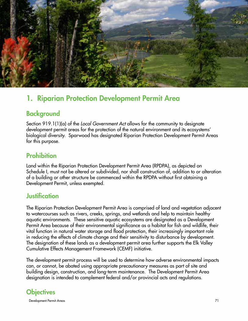
Development Permit Areas 71
1. Riparian Protection Development Permit Area
BackgroundSection 919.1(1)(a) of the Local Government Act allows for the community to designate development permit areas for the protection of the natural environment and its ecosystems’ biological diversity. Sparwood has designated Riparian Protection Development Permit Areas for this purpose.
ProhibitionLand within the Riparian Protection Development Permit Area (RPDPA), as depicted on Schedule I, must not be altered or subdivided, nor shall construction of, addition to or alteration of a building or other structure be commenced within the RPDPA without first obtaining a Development Permit, unless exempted.
Justification
The Riparian Protection Development Permit Area is comprised of land and vegetation adjacent to watercourses such as rivers, creeks, springs, and wetlands and help to maintain healthy aquatic environments. These sensitive aquatic ecosystems are designated as a Development Permit Area because of their environmental significance as a habitat for fish and wildlife, their vital function in natural water storage and flood protection, their increasingly important role in reducing the effects of climate change and their sensitivity to disturbance by development. The designation of these lands as a development permit area further supports the Elk Valley Cumulative Effects Management Framework (CEMF) initiative.
The development permit process will be used to determine how adverse environmental impacts can, or cannot, be abated using appropriate precautionary measures as part of site and building design, construction, and long-term maintenance. The Development Permit Area designation is intended to complement federal and/or provincial acts and regulations.
Objectives

72 Our Future Sparwood - District of Sparwood Official Community Plan
The objective of the Riparian Protection Development Permit Area is to minimize negative impacts (disturbance) on riparian areas by:
• Restoring, protecting and enhancing riparian areas to promote a functioning ecosystem;
• Protecting and/or enhancing water quality;
• Preventing the introduction or spread of invasive species;
• Minimizing soil disturbance;
• Protecting the hydrological functions of environmentally sensitive areas; and
• Protecting biological diversity, wildlife and important wildlife habitats, features and functions.
ExemptionsA Riparian Protection Development Permit will not be required when:
1. A covenant that effectively protects the entire Riparian Protection area from any form of development is registered under the Land Title Act for the subject property, all the conditions in the covenant have been met, and the proposed development will not affect any portion of the Riparian Protection area;
2. The proposed development is for interior renovations which would not result in any further encroachment within the Riparian Protection Area.
3. The only activity being proposed onsite relates to the removal of hazardous and beetle-attacked timber and a report prepared by a certified forestry professional, registered in British Columbia and qualified as a Wildlife/Danger Tree Assessor, has been submitted which concludes the trees are hazardous as determined by the Chief Administrative Officer or their designate;
4. The development activity is on Crown Land and involves mining, timber harvesting, forest road construction, open livestock range, grazing enhancement, forest recreation or other forest management activity that is conducted under the auspices of the province;
5. Actions and activities that are necessary in order to prevent immediate threat to life or property; or
6. The activity proposed on the site will not impact the Riparian Protection area relates solely to normal farm practices in accordance with the Farm Practices Protection Act and the landowner follows other requirements or regulations listed in the Act.

Development Permit Areas 73
Performance BondingSparwood may require the applicant to submit a cost estimate, prepared by a qualified professional and accepted by Sparwood, for the rehabilitation and restoration of the Riparian Protection area. The applicant will provide adequate financial security, as determined by Sparwood, prior to the issuance of any building approval or site disturbance.
The value of the financial security will be based upon the estimated cost of:
• Rehabilitating and restoring the Riparian Protection area;
• Rehabilitating and restoring the Riparian Protection area, in the event that the Riparian Protection area is damaged as a consequence of a contravention of a condition contained in the development permit; and
• Repairing damage caused by construction or site disturbance.
GuidelinesIn setting Development Permit (DP) conditions, Sparwood may cite provincial, or federal government policies, regulations, guidelines and Best Management Practices (BMPs).
The general guidelines for issuing development permits for Riparian Protection are set forth below and apply only to the Riparian Protection Areas set forth in Figure 9. However, not all guidelines will apply to all developments. Typically, an assessment report prepared by a Qualified Professional in the relevant discipline and licensed to practice in British Columbia will be required. Report recommendations may be used by the designated authority to determine conditions for the Development Permit.
1.1 Ensure that development activities do not negatively impact the quality of surface water.
1.2 Ensure that land development and associated activities do not impact base flows, natural drainage patterns, and the natural stream channel geometry.
1.3 Protect natural watercourse function and manage as open streams excepting as may be authorized by the Province of BC for flood protection.
1.4 Maintain normal riparian processes such as flooding, seasonal drawdown, and groundwater recharge excepting as may be authorized by the Province of BC for flood protection.
1.5 Implement measures to prevent spills of oil, grease, and other contaminants from entering into adjacent watercourses (e.g. oil/grit separators, biofiltration, and siltation ponds).
1.6 Reduce impervious surfaces through use of permeable materials and techniques to

74 Our Future Sparwood - District of Sparwood Official Community Plan
improve absorption (e.g. gravel, pavers, grasscrete, grass field for overflow parking).
1.7 Manage and minimize opportunities for livestock crossings and access to water.
1.8 Require that runoff is directed to suitable locations (e.g. granular and grass swales that discharge to open space) if not part of the natural drainage pattern.
1.9 Use constructed wetlands and detention ponds to slow the rate of runoff and improve the quality of rainwater through biofiltration.
1.10 Retain as much existing vegetation as possible and plant native trees and shrubs to restore the vegetative mass where clearing is unavoidable.
1.11 In the context of land disturbance, the applicant will ensure the safe collection and conveyance of onsite drainage such that no downstream or immediately adjacent properties are adversely affected if natural drainage patterns are altered by such land disturbance. Such works will also divert drainage away from hazardous condition (e.g. steep slopes) areas.
RIPARIAN PROTECTION AREAS
1.12 Riparian protection area setback widths are measured perpendicular from the watercourse according to the following (see Figure 9):
a) Elk River, creeks and streams – measured from the natural boundary;b) Ravines and other stream corridors with steeply pitched banks – measured
from the top of the ravine bank; andc) Wetlands and water bodies with gradually sloping shores – measured
perpendicularly from the natural boundary

Development Permit Areas 75
Watercourse Riparian Protection Setback Distances (metres)Elk River 30Michel Creek 30Alexander Creek 30
Summit Lake 30
Bodie Creek 15Cummings Creek 15Erickson Creek 15Summit Creek 15Unnamed tributaries of the Elk River and Michel Creek
10
ONGOING MAINTENANCE
Works located within the Riparian Protection Areas, will require maintenance (ie. landscaping) for a period of two years, in areas that have been rehabilitated or restored.
Improvements located in Riparian Protection Areas may require registration of restrictive covenants to ensure the long-term protection of areas that have been rehabilitated or restored.
MONITORING
A Qualified Professional will be required to provide ongoing monitoring of Development Permit conditions during the two year maintenance period.
Figure 9: Minimum Riparian Protection Areas designates distance from the natural boundary.

76 Our Future Sparwood - District of Sparwood Official Community Plan
2. Hazard Land Development Permit Areas
BackgroundThe Hazard Lands Development Permit Area is designated under Section 919.1(1)(a) of the Local Government Act allowing for the establishment of objectives and the provision of guidelines for the protection of development from hazardous conditions.
ProhibitionLand within the Hazard Land Development Permit Area (HLDPA), as depicted on Schedule J, K, and L, must not be altered or subdivided, nor shall construction of, addition to or alteration of a building or other structure commence within the HLDPA without first obtaining a Development Permit, unless exempted.
Properties AffectedAll areas designated as Hazard Lands Development Permit Area are illustrated on Schedule J: Steep Slopes Hazard Lands Development Permit Area Map, Schedule K: Avalanche Hazard Lands Development Permit Area Map, and Schedule L: Floodplain Hazard Lands Development Permit Area Map and are known to contain avalanche paths, steep slopes, and the 1:200 year floodplain.
Justification
Sparwood is located in a valley framed by steep slopes known to experience flooding, erosion, land slips and subsidence, avalanches, and other slope stability hazards. As well, the 1:200 year floodplain surrounding the Elk River and its tributaries exists within the municipality’s boundaries. Sparwood strives to ensure that the development of land in the community does not result in damage to personal property or injury to people. Known hazards are documented in the 1994 “Hazard Land Study – Assessment and Management.”
Exemptions

Development Permit Areas 77
Lands conforming to the regulations contained in the Farm Practices Protection Act, Mines Act, and Forest Act of BC.
A Hazard Lands Development Permit is not required for reconstruction if a building is damaged or destroyed to the extent of less than 75% of its value above its foundations, as determined by the building inspector, and if the structure remains on its existing foundation..
The requirement to obtain a Development Permit before issuance of a Building Permit, Subdivision Approval, or the alteration of land will not apply in the following instances:
• Placement of manufactured homes on pad sites approved by a Manufactured Home Park Permit and where the Flood Control Elevation has been established;
• Emergency works, including tree cutting, necessary to remove an immediate danger or hazard; or
• Minor site clearing necessary for topographic work or similar surveys that aid in site and servicing planning.
Performance BondingIn accordance with the Local Government Act, Sparwood may require that the Development Permit applicant provide security to ensure that conditions respecting landscaping are satisfied, or that unsafe conditions resulting from a contravention of a condition in the Development Permit are rectified.
Development Permit ConditionsSparwood may, in order to achieve satisfaction of the guidelines below, issue a development permit that:
• Imposes conditions and requirements with respect to the sequence and timing of construction;
• Varies or supplements a bylaw dealing with subdivision servicing requirements or land use designation requirements. Conditions and requirements may vary use or density of land only in relation to health, safety or protection of property from damage (See Section 920 (2)(a) of the Local Government Act); and,
• Includes requirements and conditions or sets standards for:
a) Areas of land that may be subject to flooding, mud flows, torrents of debris, erosion, land slip, rock falls, subsidence, avalanche or wildfire, or to another specified hazard. These areas may be required to remain free of development, except in accordance with any conditions contained in the Development Permit;
b) An area that the Development Permit designates as containing unstable soil or water that is subject to degradation. In these areas Sparwood can require

78 Our Future Sparwood - District of Sparwood Official Community Plan
that no septic tanks and deposit fields, drainage, irrigation or water systems be constructed;
c) Council may, where a Development Permit is required, request the applicant to provide development approval information. Development approval information will be required if the effects of the proposed development in relation to Development Permit objectives, OCP policies, and other District bylaws and regulations cannot be fully assessed based on information otherwise available. Development approval information will be used to assist Sparwood in determining conditions for requirements to be imposed in the Development Permit.
GuidelinesThe following guidelines may be applied when reviewing Development Permit applications and setting conditions:
STEEP SLOPES
2.1 Development of lands with a slope in excess of 15% will require a hazard lands development permit.
2.2 Development will be directed to appropriate areas with slopes averaging less than 20%.
2.3 Where it can be demonstrated, by a Qualified Professional Geotechnical Engineer, that the proposed development will be sensitively integrated with the natural environment and will present no hazards to people or property, development may be permitted on land with a natural slope that averages more than 20%.
2.4 Applicants seeking to pursue developments on slopes in excess of 15% must submit a report prepared by a Qualified Professional Geotechnical Engineer that provides information about the anticipated onsite and offsite environmental and geotechnical impacts associated with the development.
2.5 A Construction Management Plan shall be prepared for any development on land with a natural slope that averages more than 20%.
2.6 Development on steep slopes should be sensitively integrated with the surrounding lands so as to minimize visibility from areas that are down slope of the development.
2.7 Retain natural vegetation on sloped areas to reduce the potential for rock falls, erosion and landslip.
2.8 Align roads and driveways with the natural contour of the land to achieve appropriate

Development Permit Areas 79
design gradients while minimizing retaining structures and land disturbance.
2.9 Surface water control in steeper areas may include intermediate surface catchment and direction to storm water systems, where applicable.
2.10 A Section 219 restrictive covenant may be required by the District at the time of subdivision stipulating areas that must remain free of development or soil disturbance, and conditions under which development may take place.
AVALANCHE AREAS
2.11 No development is permitted within areas designated as avalanche areas unless a study, completed by a Qualified Professional Geotechnical Engineer, with experience in avalanche risk assessment, can define the limits of an avalanche flow path, including a definition of dense flow and powder avalanche hazard run-out zones, and can prescribe applicable development design criteria that will protect life and property.
FLOODPLAIN
2.12 Development of lands within the 1:200 year floodplain requires a Hazard Lands Development Permit. In the event that development is proposed within the RPDPA as well, a Riparian Protection Development Permit shall be required as well.
2.13 Refer to the Water Stewardship Branch those applications for development on properties within the Branch’s required floodplain management setback from a watercourse.
2.14 Any river modification, including rechannelling, dyking, damming or shore treatment, including riprap or any other anti-erosion technique must be approved by the federal and provincial agencies having jurisdiction.

80 Our Future Sparwood - District of Sparwood Official Community Plan
3. Form and Character Development Permit Area
BackgroundThe Form and Character Development Permit Area is designated under Section 919.1(1)(f) of the Local Government Act allowing for the establishment of objectives for the form and character of multi-family residential, commercial, or industrial development.
Prohibition
Land within the Form and Character Development Permit Area (FCDPA) area must not be subdivided and construction of, addition to or alteration of a building or other structure must not be started without first obtaining a Development Permit.
Properties AffectedAll areas designated as FCDPA are illustrated on Schedule M: Form and Character Development Permit Area Map.
JustificationIncreasing design expectations from residents require that Design Guidelines with respect to site layout, building form and character, and landscaping apply to multi-family residential, commercial, and light industrial development.
ExemptionsThe following do not require a development permit:
i. An addition or alteration to an existing principal building which will not be visible from an existing or future adjacent public road right-of-way, adjacent park, or adjacent residential property, provided that the proposal requires no variance(s) from the Zoning Bylaw, and further, requires no approval from the appropriate

Development Permit Areas 81
provincial ministry or agency;
ii. Interior renovations; or
iii. Replacement of a building that has been destroyed by natural causes, in cases where the replacement building is identical to the original in both form and character.
Performance BondingIn accordance with the Local Government Act, Sparwood may require that the Development Permit applicant provide security to ensure that conditions respecting landscaping are satisfied; or that unsafe conditions resulting from a contravention of a condition in the Development Permit are rectified.
GuidelinesThe following guidelines may be applied when reviewing Development Permit applications and setting conditions. In addition to the guidelines, proponents are encouraged to follow the Best Practices for form and character in Appendix 3 when designing their projects.
AUTHENTICITY
3.1 Incorporate building form and character that is distinct to the region’s natural mountain setting;
3.2 Incorporate forms that relate to the region’s natural and cultural landscapes.
CONTEXT
3.3 Emulate desirable form and character of nearby buildings;
3.4 Design new multi-storey buildings to transition in height where the OCP land use designation provides for smaller structures on adjoining lots;
3.5 Allow eclecticism within the streetscape as long as buildings do not visually dominate neighbouring buildings;
3.6 Design developments with multiple buildings such that there is a sense of architectural unity or cohesiveness.
RELATIONSHIP TO THE STREET
3.7 Locate buildings to provide an effective street edge while respecting the established, desired streetscape rhythm;
3.8 Develop visual and physical connections between the public street and private buildings

82 Our Future Sparwood - District of Sparwood Official Community Plan
by maintaining views to and from active interior spaces. This can be accomplished through patios, window placement and glazing, awnings, and canopies;
3.9 Design buildings with multiple street frontages and give equal emphasis to each frontage with respect to building massing, materials, details, and landscaping.
MASSING AND HEIGHT
3.10 Mitigate the actual and perceived bulk of buildings by utilizing appropriate massing, including:
a) Architectural elements such as balconies, bay windows, cantilevered floors, cupolas, dormers;
b) Visually-interesting rooflines;c) Stepped-back upper floors to reduce visual impact.
3.11 Ensure developments are sensitive to and compatible with the massing of the established and future streetscape;
3.12 Design developments with multiple buildings such that individual buildings are of different but compatible shapes and masses;
3.13 Design with consideration for the effect of building height on shadowing and views.
3.14 Provide visually prominent, accessible, and recognizable entrances through attention to location, details, proportions, materials, landscaping, and lighting that act to personalize or lend identity to a building;
HUMAN SCALE
3.15 Incorporate roof overhangs;
3.16 Incorporate windows within enclosed stairwells to exhibit human scale, reduce their visual bulk, and enhance safety;
PUBLIC AND PRIVATE OPEN SPACE
3.17 Provide an appropriate transition between public and private open space using landscaping, gathering places, architectural elements, or varied building lines and orienting building elements such as entrances, lobbies, windows, and balconies to face public parks, plazas, and open spaces;
3.18 Design buildings such that snow shedding from the roof does not impact walkways, entrances, balconies, or parking areas.

Development Permit Areas 83
PEDESTRIAN ACCESS, PROVISION FOR CYCLISTS, CIRCULATION, VEHICLES AND LOADING
3.19 Design vehicular drop-off and pick-up areas so that pedestrians have priority;
3.20 Where possible, locate parking areas towards the rear of buildings, internal to the building, or below grade;
3.21 Avoid large expanses of parking;
3.22 Ensure vehicular and service access has minimal impact on the streetscape;
3.23 Avoid vehicle access from arterial and collector roads and from those roads with a prominent streetscape.
ENVIRONMENTAL DESIGN AND GREEN BUILDING
3.24 Minimize solar gain through building orientation and facade elements and/or utilize measures to capitalize on solar exposure such as passive solar water heating, solar mass wall, or passive solar heating of intake air;
3.25 Minimize exposure to noise and pollution, especially for those projects located along busy roads;
AMENITIES, ANCILLARY SERVICES, UTILITIES, AND LIGHTING
3.26 Locate loading, garbage, storage, utilities and other ancillary services away from public view. All such areas should be screened and designed as an integral part of the building where possible to minimize impact.
3.27 On-site snow storage from parking lot clearing shall be incorporated in the site design.
3.28 Ensure that “light trespass” into adjacent residential areas is minimized.

84 Our Future Sparwood - District of Sparwood Official Community Plan

Appendices 85
PART IV: Appendices & Schedules

86 Our Future Sparwood - District of Sparwood Official Community Plan
PAGE INTENTIONALLY BLANK

Appendices 87
Schedule A: Sparwood OCP Boundary and Context .........................................92Schedule B: Future Land Use Map ..................................................................93Schedule C: Infill / Redevelopment Area ..........................................................94Schedule D: Downtown Map ..........................................................................95Schedule E: Infrastructure Map - Transportation ................................................96Schedule F: Infrastructure Map – Water Phasing ................................................97Schedule G: Infrastructure Map – Sewer Phasing ...............................................98Schedule H: Parks and Natural Areas ..............................................................99Schedule I: Riparian Protection Development Permit Area .................................100Schedule J: Steep Slopes Hazard Development Permit Area ..............................101Schedule K: Avalanche Hazard Development Permit Area ................................102Schedule L: Floodplain Hazard Development Permit Area .................................103Schedule M: Form and Character Development Permit Area .............................104
Appendix 1: OCP Process & Acknowledgements ............................................106Appendix 2: Definitions ...............................................................................110Appendix 3: Best Practices for Form and Character .........................................111
Index of Schedules
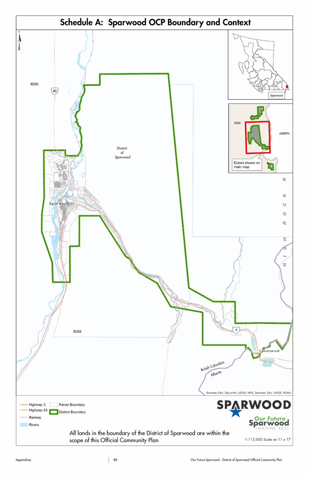
Appendices 88 Our Future Sparwood - District of Sparwood Official Community Plan

Appendices 89 Our Future Sparwood - District of Sparwood Official Community Plan
Schedule B: Future Land Use Map

Appendices 90 Our Future Sparwood - District of Sparwood Official Community Plan
Schedule C: Infill / Redevelopment Area

Appendices 91 Our Future Sparwood - District of Sparwood Official Community Plan
Schedule D: Downtown Map

Appendices 92 Our Future Sparwood - District of Sparwood Official Community Plan
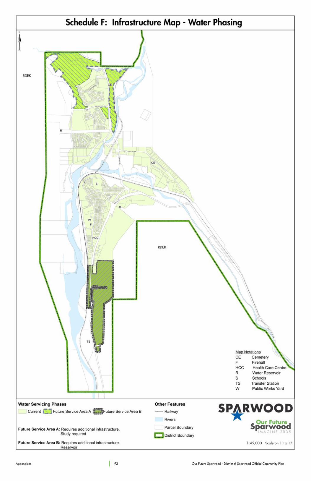
Appendices 93 Our Future Sparwood - District of Sparwood Official Community Plan
Schedule F: Infrastructure Map – Water Phasing

Appendices 94 Our Future Sparwood - District of Sparwood Official Community Plan

Appendices 95 Our Future Sparwood - District of Sparwood Official Community Plan
Schedule H: Parks and Natural Areas

Appendices 96 Our Future Sparwood - District of Sparwood Official Community Plan

Appendices 97 Our Future Sparwood - District of Sparwood Official Community Plan
Schedule J: Steep Slopes Hazard Development Permit Area

Appendices 98 Our Future Sparwood - District of Sparwood Official Community Plan
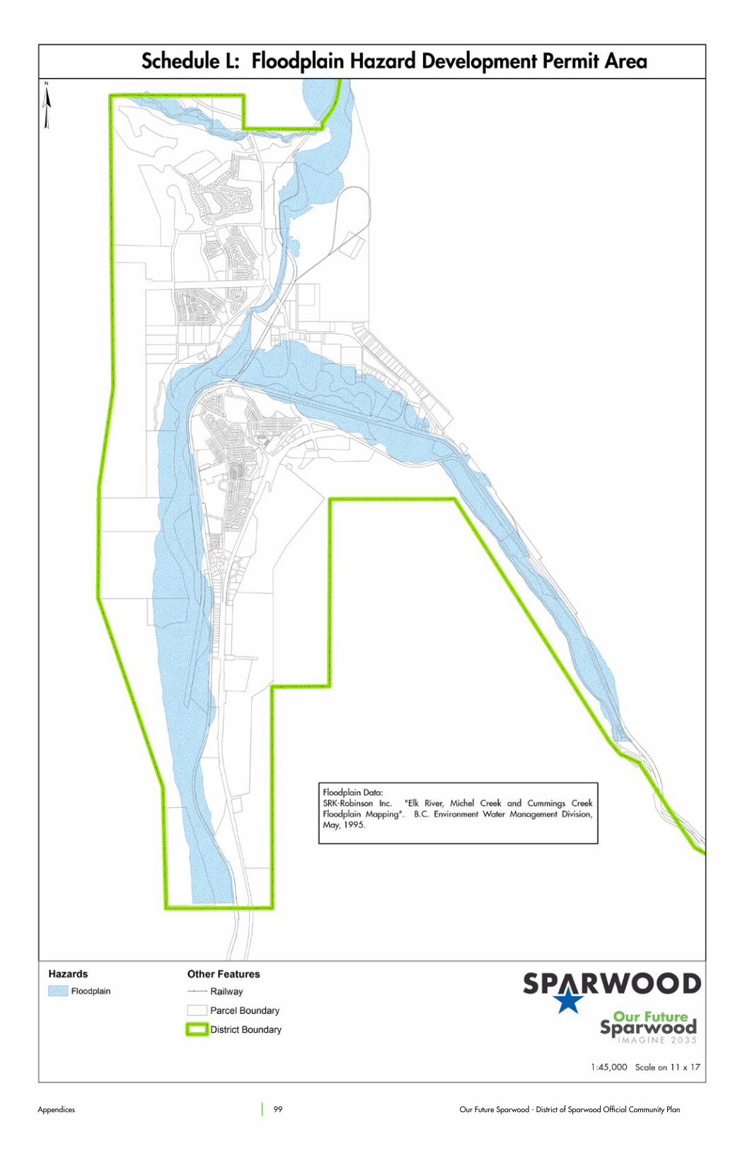
Appendices 99 Our Future Sparwood - District of Sparwood Official Community Plan
Schedule L: Floodplain Hazard Development Permit Area

Appendices 100 Our Future Sparwood - District of Sparwood Official Community Plan

Appendices 101 Our Future Sparwood - District of Sparwood Official Community Plan

102 Our Future Sparwood - District of Sparwood Official Community Plan
Appendix 1: AcknowledgementsThe preparation of this Official Community Plan involved significant contributions by Sparwood’s residents, Planning Committee members, District Council, District staff and other levels of government. The following people are acknowledged for their contributions to the development of this OCP.
COUNCIL MEMBERS (2011-2014):
• Mayor Lois Halko,
• Councillor Harold Baytaluke;
• Councillor Sharon Fraser;
• Councillor Andy MacIntyre;
• Councillor Margaret McKie;
• Councillor Ron Saad; and,
• Councillor Joanne Wilton
COUNCIL MEMBERS (2014-2018):
• Mayor Cal McDougall;
• Councillor John Baher;
• Councillor Brad Bowen;
• Councillor Lois Halko;
• Councillor Joe Jarina;
• Councillor Jenna Jensen; and,
• Councillor Margaret McKie;

Appendices 103
MEMBERS OF OCP PLANNING TEAM:
• Tracey Brook-Baker;
• Jenna Jensen;
• Tracy Kaisner;
• Tammie Davy;
• Cal McDougall;
• Nicole Palone;
• Councillor Andy MacIntyre;
• Councillor Joanne Wilton; and,
• Mayor Lois Halko.
DISTRICT ADMINISTRATION AND STAFF:
• Terry Melcer, Chief Administrative Officer;
• Nelson Wight, Manager of Planning;
• Jessica Wheeler, Planning Assistant;
• Christopher Evan Jones, Planning Assistant;
• Raeleen Manjak, Director of Corporate Services;
• Danny Dwyer, Director of Engineering / Subdivision Approving Officer;
• Mel Bohmer, Director of Operations;
• James Jones, Director of Fire Services;
• Duane Lawrence, Director of Community and Facility Services;
• Barbara Nunes, Director of Finance;
• Louise Kaiser, Deputy Director of Finance; and,
• Jude Smith, Business Development Liason.

104 Our Future Sparwood - District of Sparwood Official Community Plan
Appendix 2: DefinitionsAccessibility: Means that a person with disabilities is, without assistance, able to approach, enter, pass to and from, and make use of an area and its facilities.
Natural Boundary (as per the Land Act): means the visible high water mark of any lake, river, stream or other body of water where the presence and action of the water are so common and usual, and so long continued in all ordinary years, as to mark on the soil of the bed of the body of water a character distinct from that of its banks, in vegetation, as well as in the nature of the soil itself;
Watercourse: Any natural or man-made depression with well-defined banks and a bed 0.6 metres or more below the surrounding land serving to give direction to a current of water at least six month of the year or having a drainage area of two square kilometres or more or as required by a designated official of the Ministry of the Environment of the Province of British Columbia
Qualified Environmental Professional: A registered professional, acting alone or together with another registered professional, if:
1. The individual is registered and in good standing in British Columbia with an appropriate professional organization constituted under an Act, acting under that association’s code of ethics and subject to disciplinary action by that association;
2. The individual’s area of expertise is recognized by the District of Sparwood as one that is acceptable for the purpose of providing all or part of an assessment report in respect of that development proposal; and,
3. The individual is acting within that individual’s area of expertise.
Qualified Professional: A professional with appropriate education, training and experience, fully insured and in good standing with the relevant professional association, and means:
1. For the purpose of the flood and slope hazard assessments (Riparian DPA and Hazard Lands DPA), a specialist Professional Engineer or Professional Geoscientist, as appropriate, with experience or training in geotechnical and geohazard assessments,

Appendices 105
river hydraulics and hydrology and, where appropriate, debris flow processes experience or training and/or structural engineering expertise in connection with mitigation works.
Ravine: A narrow, steep-sided valley commonly, but not always, eroded by running water and that has a slope grade greater than 3:1
Visitability: Refers to new homes that offer three specific accessibility features that allow a person with mobility limitations, including wheelchair users, to visit the home: 1) at least one zero-step entrance on an accessible route leading from a driveway or public sidewalk; 2) all interior doors providing at least 31 3⁄4 inches (81 cm) of unobstructed passage space; and 3) at least a half bathroom on the main floor.

106 Our Future Sparwood - District of Sparwood Official Community Plan
Appendix 3: Best Practices for Form and CharacterRELATIONSHIP TO THE STREET
1. For commercial and light industrial sites, develop visual and physical connections between the public street and private buildings by maintaining views to and from active interior spaces. This can be accomplished through patios, window placement and glazing, awnings, and canopies.
HUMAN SCALE
2. Design for human scale and visual interest in all building elevations. This can be achieved principally by giving emphasis to doors and windows and other signs of human habitation relative to walls and building structure;
3. Articulate facades by means of indentations and projections of elements such as windows and doors, cornice lines, pilasters, balconies, and other detailing;
4. Design building facades with a balance of vertical and horizontal proportions using vertical elements at regular intervals to strengthen the pedestrian-scale of otherwise horizontal buildings.
EXTERIOR ELEVATIONS AND MATERIALS
5. Exterior building materials should be selected for their functional and aesthetic quality, and should exhibit qualities of workmanship, durability, longevity and ease of maintenance;
6. Provide visually prominent, accessible, and recognizable entrances through attention to location, details, proportions, materials, landscaping, and lighting that act to personalize or lend identity to a building;
7. Continue higher quality materials used on the principal façade around any building corner or edge which is visible to the public;
8. Use materials in combination to create contrast, enhance human scale, and reduce the apparent bulk of a building;
9. Colour should not be used as the predominant feature of a building.
PUBLIC AND PRIVATE OPEN SPACE
10. Design varied and interesting public open space to promote social interaction, ensure continuity of pedestrian movement through the site, and accommodate a range of uses and activities year-round;
11. Orient public and private open spaces to take advantage of sunlight with the provision of shade and protection from wind and other climatic elements;
12. Provide an appropriate transition between public and private open space using landscaping, gathering places, architectural elements, or varied building lines and orienting building elements such as entrances, lobbies, windows, and balconies to

Appendices 107
face public parks, plazas, and open spaces;
13. Provide amenities such as benches, garbage receptacles, bicycle stands, and bollards;
14. Design commercial and light industrial developments to include outdoor break areas, green space, bicycle racks, skylights and windows in work areas, and linkages to recreational opportunities;
15. Design buildings such that snow shedding from the roof does not impact walkways, entrances, balconies, or parking areas.
PEDESTRIAN ACCESS, PROVISION FOR CYCLISTS, CIRCULATION, VEHICLES AND LOADING
16. Prioritize the safe and convenient movement of pedestrians above all other modes of transportation in the downtown and other areas where appropriate;
17. Promote the use of alternative modes of transportation in site design by including prominent bicycle racks for convenience and security, and orienting building entrances to pedestrian areas;
18. Provide an identifiable and well-lit pathway to the front entrance of every building from all adjoining public sidewalks and all on-site parking areas;
19. Ensure pedestrian circulation is convenient, safe, and clearly identifiable to drivers and pedestrians;
20. Where possible, locate parking areas to the rear of buildings, internal to the building, or below grade;
21. Avoid large expanses of parking.
DECKS, BALCONIES, ROOFTOPS, AND COMMON OUTDOOR AMENITY SPACE
22. Incorporate decks, balconies and common outdoor amenity spaces into developments;
23. Provide elements such as constructed planters, gazebos, trellises, pergolas, and other forms of hard and soft landscaping, including opportunities for urban agriculture, to enhance the usability of decks, balconies, and outdoor amenity spaces;
24. Integrate vents, mechanical rooms and equipment, and elevator penthouses with the architectural treatment of the roof, and/or screen these elements with materials and finishes compatible with the building’s design.
25. Locate loading, garbage, storage, utilities and other ancillary services away from public view. All such areas should be screened and designed as an integral part of the building where possible to minimize impact.
LANDSCAPE DEVELOPMENT AND IRRIGATION WATER CONSERVATION
26. Use landscape vegetation to reinforce building geometries, provide spatial definition, screen unwanted views, address human comfort and provide accent and focal points and other aesthetic benefits, where appropriate;

108 Our Future Sparwood - District of Sparwood Official Community Plan
27. Use landscape elements such as benches and bollards to provide seating and visual cues for pedestrian/vehicular circulation;
28. Provide fences and retaining walls designed with visual interest and human scale in mind. Examples could include high quality fencing, stone, rock walls, or punctuated at regular intervals with vertical elements such as piers or vegetation;
UNIVERSAL ACCESSIBLE DESIGN
29. Design to a high standard of accessible and adaptable design with the goal of accommodating the functional needs of all individuals including children, adults, and seniors, and those with visual, mobility or cognitive challenges;
30. Access for persons with disabilities should be appropriately designed and clearly visible from the principal entrance;
31. Access ramps and related elements should be visually integrated with the overall building design and site plan so as to not appear as an unintegrated add-on to a building façade;
32. Site layout, services and amenities should be easy to comprehend and navigate through the use of such things as strong contrast of colours, corner dots, paving treatments, bollards, and tactile strips around obstacles.
3.29 LIGHTING
33. Design lighting to enhance public safety (see Crime Prevention Through Environmental Design Guidelines) and not to draw attention to a development;
34. Consider lighting a key element in façade design and plan early for it, with consideration to the effect on the façade and on neighbouring buildings and open spaces;
35. Provide pathway lighting at a human scale such as using light standards of appropriate height for pedestrians. Pedestrian lights should address pedestrian safety, be vandal proof, and easy/inexpensive to maintain;
36. Provide exterior street lighting that follows the International Dark Sky Model code in order to limit light pollution and save energy.
SIGNS
37. Integrate signage that contributes to the overall quality and unique character of a development through such things as similar proportions, materials, and colour;
38. Do not compromise the scale and visual qualities of a building with the size and number of signs;
39. Locate, size, and format signs such that they can be easily read by pedestrians.

Appendices 109