(r-034-2008) memorandum branch managertransportation.ky.gov/construction-procurement/project...
TRANSCRIPT
(R-034-2008)
MEMORANDUM
TO: Jeff Jasper, P.E.Division of Highway Design
FROM: William Broyles, P.E.Geotechnical Engineering
Branch Manager
BY: Christopher Slone, P.E.Geotechnical Engineering
Roadway Section
DATE: September 17, 2008
SUBJECT: Hardin CountyMedian Cable Barrier System I-65Mileposts 91.086 to 100.509Item # 4-2801.00Cable Barrier Anchor Testing
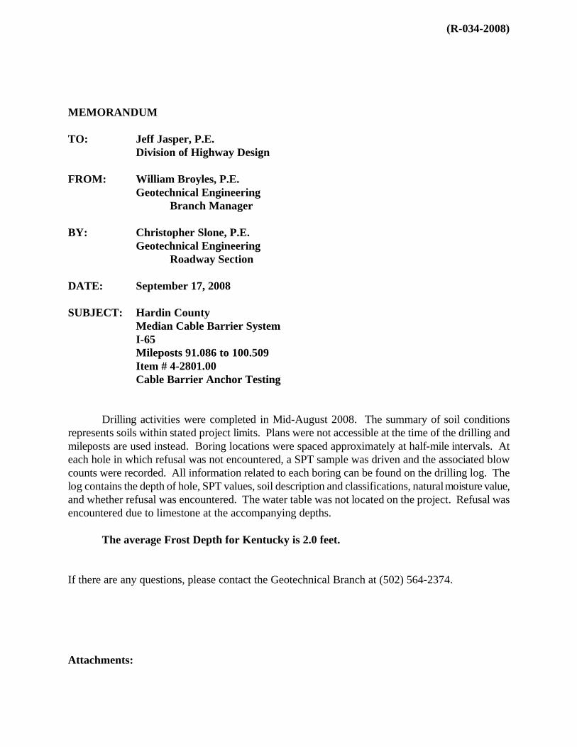
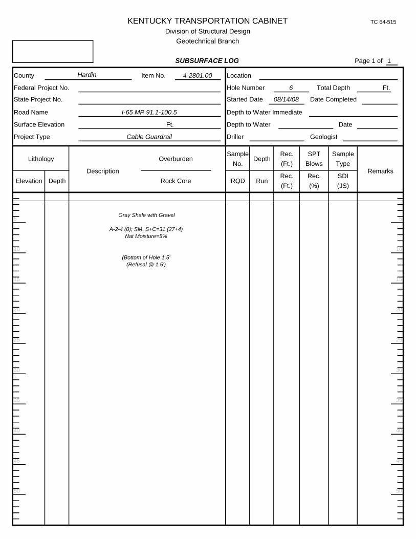
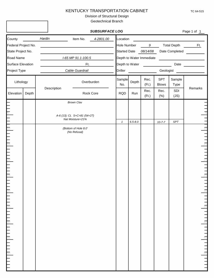
Drilling activities were completed in Mid-August 2008. The summary of soil conditions represents soils within stated project limits. Plans were not accessible at the time of the drilling and mileposts are used instead. Boring locations were spaced approximately at half-mile intervals. At each hole in which refusal was not encountered, a SPT sample was driven and the associated blow counts were recorded. All information related to each boring can be found on the drilling log. The log contains the depth of hole, SPT values, soil description and classifications, naturalmoisture value, and whether refusal was encountered. The water table was not located on the project. Refusal was encountered due to limestone at the accompanying depths.
The average Frost Depth for Kentucky is 2.0 feet.
If there are any questions, please contact the Geotechnical Branch at (502) 564-2374.
Attachments:


KENTUCKY TRANSPORTATION CABINET
DIVISION OF MATERIALSGEOTECHNICAL BRANCH
SUBSURFACE LOG (Continued)
KENTUCKY TRANSPORTATION CABINET TC 64-515
10
50
Page 1 of
45
40
25
40
50
20
15
10
5
1 Ft.
Location
Hole Number
Rec.
Rec.(Ft.)
Total Depth
Depth to Water Date
Federal Project No.
State Project No.
Road Name Depth to Water Immediate
Overburden
Rock Core(%)(Ft.) (JS)
Sample
Remarks
SPT
5
15
Blows
SDI
Type
Rec.
20
30
25
30
35 35
Item No.County 4-2801.00
I-65 MP 91.1-100.5
Ft.
Cable Guardrail
Description
1
Division of Structural DesignGeotechnical Branch
SUBSURFACE LOG
45
Surface Elevation
Project Type
Started Date Date Completed08/14/08
Driller Geologist
Depth
RunDepthElevation
LithologySample
No.
RQD
Hardin
1 6.5-8.0 8-9-9 SPT
(Bottom of Hole 8.0'(No Refusal)
A-7-6 (41); CH S+C=84 (42+42)Nat Moisture=27%
Red Clay

KENTUCKY TRANSPORTATION CABINET
DIVISION OF MATERIALSGEOTECHNICAL BRANCH
SUBSURFACE LOG (Continued)
KENTUCKY TRANSPORTATION CABINET TC 64-515
10
50
Page 1 of
45
40
25
40
50
20
15
10
5
2 Ft.
Location
Hole Number
Rec.
Rec.(Ft.)
Total Depth
Depth to Water Date
Federal Project No.
State Project No.
Road Name Depth to Water Immediate
Overburden
Rock Core(%)(Ft.) (JS)
Sample
Remarks
SPT
5
15
Blows
SDI
Type
Rec.
20
30
25
30
35 35
Item No.County 4-2801.00
I-65 MP 91.1-100.5
Ft.
Cable Guardrail
Description
1
Division of Structural DesignGeotechnical Branch
SUBSURFACE LOG
45
Surface Elevation
Project Type
Started Date Date Completed08/14/08
Driller Geologist
Depth
RunDepthElevation
LithologySample
No.
RQD
Hardin
1 6.5-8.0 3-4-4 SPT
(Bottom of Hole 8.0'(No Refusal)
A-7-6 (15); CH S+C=60 (29+31)Nat Moisture=27%
Red Clay

KENTUCKY TRANSPORTATION CABINET
DIVISION OF MATERIALSGEOTECHNICAL BRANCH
SUBSURFACE LOG (Continued)
KENTUCKY TRANSPORTATION CABINET TC 64-515
10
50
Page 1 of
45
40
25
40
50
20
15
10
5
3 Ft.
Location
Hole Number
Rec.
Rec.(Ft.)
Total Depth
Depth to Water Date
Federal Project No.
State Project No.
Road Name Depth to Water Immediate
Overburden
Rock Core(%)(Ft.) (JS)
Sample
Remarks
SPT
5
15
Blows
SDI
Type
Rec.
20
30
25
30
35 35
Item No.County 4-2801.00
I-65 MP 91.1-100.5
Ft.
Cable Guardrail
Description
1
Division of Structural DesignGeotechnical Branch
SUBSURFACE LOG
45
Surface Elevation
Project Type
Started Date Date Completed08/14/08
Driller Geologist
Depth
RunDepthElevation
LithologySample
No.
RQD
Hardin
1 6.5-8.0 1-6-7 SPT
(Bottom of Hole 8.0'(No Refusal)
A-7-6 (20); CL S+C=72 (37+35)Nat Moisture=28%
Red Clay with Boulders

KENTUCKY TRANSPORTATION CABINET
DIVISION OF MATERIALSGEOTECHNICAL BRANCH
SUBSURFACE LOG (Continued)
KENTUCKY TRANSPORTATION CABINET TC 64-515
10
50
Page 1 of
45
40
25
40
50
20
15
10
5
4 Ft.
Location
Hole Number
Rec.
Rec.(Ft.)
Total Depth
Depth to Water Date
Federal Project No.
State Project No.
Road Name Depth to Water Immediate
Overburden
Rock Core(%)(Ft.) (JS)
Sample
Remarks
SPT
5
15
Blows
SDI
Type
Rec.
20
30
25
30
35 35
Item No.County 4-2801.00
I-65 MP 91.1-100.5
Ft.
Cable Guardrail
Description
1
Division of Structural DesignGeotechnical Branch
SUBSURFACE LOG
45
Surface Elevation
Project Type
Started Date Date Completed08/14/08
Driller Geologist
Depth
RunDepthElevation
LithologySample
No.
RQD
Hardin
1 6.5-8.0 5-7-9 SPT
(Bottom of Hole 8.0'(No Refusal)
A-6 (19); CL S+C=96 (69+27)Nat Moisture=21%
Red and Gray Clay

KENTUCKY TRANSPORTATION CABINET
DIVISION OF MATERIALSGEOTECHNICAL BRANCH
SUBSURFACE LOG (Continued)
Depth
RunDepthElevation
LithologySample
No.
RQD
Driller Geologist
Started Date Date Completed08/14/08
45
Surface Elevation
Project Type
1
Division of Structural DesignGeotechnical Branch
SUBSURFACE LOG
Ft.
Cable Guardrail
Description
Item No.County 4-2801.00
I-65 MP 91.1-100.5
30
25
30
35 35
20
SPT
5
15
Blows
SDI
Type
Rec.(%)(Ft.) (JS)
Sample
Remarks
Overburden
Rock Core
Federal Project No.
State Project No.
Road Name Depth to Water Immediate
Rec.
Rec.(Ft.)
Total Depth
Depth to Water Date
5 Ft.
Location
Hole Number
5
10
15
20
50
40
25
40
45
Page 1 of
50
KENTUCKY TRANSPORTATION CABINET TC 64-515
10
Hardin
(Bottom of Hole 5.5'(Refusal @ 5.5')
A-6 (13); CL S+C=68 (46+22)Nat Moisture=20%
Gray Shale with Clay Layers
KENTUCKY TRANSPORTATION CABINET
DIVISION OF MATERIALSGEOTECHNICAL BRANCH
SUBSURFACE LOG (Continued)
KENTUCKY TRANSPORTATION CABINET TC 64-515
10
50
Page 1 of
45
40
25
40
50
20
15
10
5
6 Ft.
Location
Hole Number
Rec.
Rec.(Ft.)
Total Depth
Depth to Water Date
Federal Project No.
State Project No.
Road Name Depth to Water Immediate
Overburden
Rock Core(%)(Ft.) (JS)
Sample
Remarks
SPT
5
15
Blows
SDI
Type
Rec.
20
30
25
30
35 35
Item No.County 4-2801.00
I-65 MP 91.1-100.5
Ft.
Cable Guardrail
Description
1
Division of Structural DesignGeotechnical Branch
SUBSURFACE LOG
45
Surface Elevation
Project Type
Started Date Date Completed08/14/08
Driller Geologist
Depth
RunDepthElevation
LithologySample
No.
RQD
Hardin
(Bottom of Hole 1.5'(Refusal @ 1.5')
A-2-4 (0); SM S+C=31 (27+4)Nat Moisture=5%
Gray Shale with Gravel
KENTUCKY TRANSPORTATION CABINET
DIVISION OF MATERIALSGEOTECHNICAL BRANCH
SUBSURFACE LOG (Continued)
KENTUCKY TRANSPORTATION CABINET TC 64-515
10
50
Page 1 of
45
40
25
40
50
20
15
10
5
7 Ft.
Location
Hole Number
Rec.
Rec.(Ft.)
Total Depth
Depth to Water Date
Federal Project No.
State Project No.
Road Name Depth to Water Immediate
Overburden
Rock Core(%)(Ft.) (JS)
Sample
Remarks
SPT
5
15
Blows
SDI
Type
Rec.
20
30
25
30
35 35
Item No.County 4-2801.00
I-65 MP 91.1-100.5
Ft.
Cable Guardrail
Description
1
Division of Structural DesignGeotechnical Branch
SUBSURFACE LOG
45
Surface Elevation
Project Type
Started Date Date Completed08/14/08
Driller Geologist
Depth
RunDepthElevation
LithologySample
No.
RQD
Hardin
(Bottom of Hole 4.5'(Refusal @ 4.5')
A-6 (3); CL S+C=50 (35+15)Nat Moisture=13%
Weathered Limestone and Clay

KENTUCKY TRANSPORTATION CABINET
DIVISION OF MATERIALSGEOTECHNICAL BRANCH
SUBSURFACE LOG (Continued)
Depth
RunDepthElevation
LithologySample
No.
RQD
Driller Geologist
Started Date Date Completed08/14/08
45
Surface Elevation
Project Type
1
Division of Structural DesignGeotechnical Branch
SUBSURFACE LOG
Ft.
Cable Guardrail
Description
Item No.County 4-2801.00
I-65 MP 91.1-100.5
30
25
30
35 35
20
SPT
5
15
Blows
SDI
Type
Rec.(%)(Ft.) (JS)
Sample
Remarks
Overburden
Rock Core
Federal Project No.
State Project No.
Road Name Depth to Water Immediate
Rec.
Rec.(Ft.)
Total Depth
Depth to Water Date
8 Ft.
Location
Hole Number
5
10
15
20
50
40
25
40
45
Page 1 of
50
KENTUCKY TRANSPORTATION CABINET TC 64-515
10
Hardin
1 6.5-8.0 7-6-7 SPT
(Bottom of Hole 8.0'(No Refusal)
A-6 (14); CL S+C=80 (50+30)Nat Moisture=18%
Brown Clay
KENTUCKY TRANSPORTATION CABINET
DIVISION OF MATERIALSGEOTECHNICAL BRANCH
SUBSURFACE LOG (Continued)
Depth
RunDepthElevation
LithologySample
No.
RQD
Driller Geologist
Started Date Date Completed08/14/08
45
Surface Elevation
Project Type
1
Division of Structural DesignGeotechnical Branch
SUBSURFACE LOG
Ft.
Cable Guardrail
Description
Item No.County 4-2801.00
I-65 MP 91.1-100.5
30
25
30
35 35
20
SPT
5
15
Blows
SDI
Type
Rec.(%)(Ft.) (JS)
Sample
Remarks
Overburden
Rock Core
Federal Project No.
State Project No.
Road Name Depth to Water Immediate
Rec.
Rec.(Ft.)
Total Depth
Depth to Water Date
9 Ft.
Location
Hole Number
5
10
15
20
50
40
25
40
45
Page 1 of
50
KENTUCKY TRANSPORTATION CABINET TC 64-515
10
Hardin
1 6.5-8.0 10-7-7 SPT
(Bottom of Hole 8.0'(No Refusal)
A-6 (13); CL S+C=81 (54+27)Nat Moisture=21%
Brown Clay

KENTUCKY TRANSPORTATION CABINET
DIVISION OF MATERIALSGEOTECHNICAL BRANCH
SUBSURFACE LOG (Continued)
Depth
RunDepthElevation
LithologySample
No.
RQD
Driller Geologist
Started Date Date Completed08/14/08
45
Surface Elevation
Project Type
1
Division of Structural DesignGeotechnical Branch
SUBSURFACE LOG
Ft.
Cable Guardrail
Description
Item No.County 4-2801.00
I-65 MP 91.1-100.5
30
25
30
35 35
20
SPT
5
15
Blows
SDI
Type
Rec.(%)(Ft.) (JS)
Sample
Remarks
Overburden
Rock Core
Federal Project No.
State Project No.
Road Name Depth to Water Immediate
Rec.
Rec.(Ft.)
Total Depth
Depth to Water Date
10 Ft.
Location
Hole Number
5
10
15
20
50
40
25
40
45
Page 1 of
50
KENTUCKY TRANSPORTATION CABINET TC 64-515
10
Hardin
1 6.5-8.0 3-4-5 SPT
(Bottom of Hole 8.0'(No Refusal)
A-6 (4); CL S+C=51 (37+14)Nat Moisture=24%
Brown Clay

KENTUCKY TRANSPORTATION CABINET
DIVISION OF MATERIALSGEOTECHNICAL BRANCH
SUBSURFACE LOG (Continued)
Depth
RunDepthElevation
LithologySample
No.
RQD
Driller Geologist
Started Date Date Completed08/14/08
45
Surface Elevation
Project Type
1
Division of Structural DesignGeotechnical Branch
SUBSURFACE LOG
Ft.
Cable Guardrail
Description
Item No.County 4-2801.00
I-65 MP 91.1-100.5
30
25
30
35 35
20
SPT
5
15
Blows
SDI
Type
Rec.(%)(Ft.) (JS)
Sample
Remarks
Overburden
Rock Core
Federal Project No.
State Project No.
Road Name Depth to Water Immediate
Rec.
Rec.(Ft.)
Total Depth
Depth to Water Date
11 Ft.
Location
Hole Number
5
10
15
20
50
40
25
40
45
Page 1 of
50
KENTUCKY TRANSPORTATION CABINET TC 64-515
10
Hardin
(Bottom of Hole 4.0'(Refusal @ 4.0')
A-6 (4); SC S+C=49 (33+16)Nat Moisture=15%
Brown Clay

KENTUCKY TRANSPORTATION CABINET
DIVISION OF MATERIALSGEOTECHNICAL BRANCH
SUBSURFACE LOG (Continued)
Depth
RunDepthElevation
LithologySample
No.
RQD
Driller Geologist
Started Date Date Completed08/14/08
45
Surface Elevation
Project Type
1
Division of Structural DesignGeotechnical Branch
SUBSURFACE LOG
Ft.
Cable Guardrail
Description
Item No.County 4-2801.00
I-65 MP 91.1-100.5
30
25
30
35 35
20
SPT
5
15
Blows
SDI
Type
Rec.(%)(Ft.) (JS)
Sample
Remarks
Overburden
Rock Core
Federal Project No.
State Project No.
Road Name Depth to Water Immediate
Rec.
Rec.(Ft.)
Total Depth
Depth to Water Date
12 Ft.
Location
Hole Number
5
10
15
20
50
40
25
40
45
Page 1 of
50
KENTUCKY TRANSPORTATION CABINET TC 64-515
10
Hardin
(Bottom of Hole 3.5'(Refusal @ 3.5')
A-6 (9); CL S+C=66 (42+24)Nat Moisture=20%
Brown Clay

KENTUCKY TRANSPORTATION CABINET
DIVISION OF MATERIALSGEOTECHNICAL BRANCH
SUBSURFACE LOG (Continued)
Depth
RunDepthElevation
LithologySample
No.
RQD
Driller Geologist
Started Date Date Completed08/14/08
45
Surface Elevation
Project Type
1
Division of Structural DesignGeotechnical Branch
SUBSURFACE LOG
Ft.
Cable Guardrail
Description
Item No.County 4-2801.00
I-65 MP 91.1-100.5
30
25
30
35 35
20
SPT
5
15
Blows
SDI
Type
Rec.(%)(Ft.) (JS)
Sample
Remarks
Overburden
Rock Core
Federal Project No.
State Project No.
Road Name Depth to Water Immediate
Rec.
Rec.(Ft.)
Total Depth
Depth to Water Date
13 Ft.
Location
Hole Number
5
10
15
20
50
40
25
40
45
Page 1 of
50
KENTUCKY TRANSPORTATION CABINET TC 64-515
10
Hardin
(Bottom of Hole 4.0'(Refusal @ 4.0')
A-6 (7); CL S+C=63 (40+23)Nat Moisture=12%
Brown Clay

KENTUCKY TRANSPORTATION CABINET
DIVISION OF MATERIALSGEOTECHNICAL BRANCH
SUBSURFACE LOG (Continued)
Depth
RunDepthElevation
LithologySample
No.
RQD
Driller Geologist
Started Date Date Completed08/14/08
45
Surface Elevation
Project Type
1
Division of Structural DesignGeotechnical Branch
SUBSURFACE LOG
Ft.
Cable Guardrail
Description
Item No.County 4-2801.00
I-65 MP 91.1-100.5
30
25
30
35 35
20
SPT
5
15
Blows
SDI
Type
Rec.(%)(Ft.) (JS)
Sample
Remarks
Overburden
Rock Core
Federal Project No.
State Project No.
Road Name Depth to Water Immediate
Rec.
Rec.(Ft.)
Total Depth
Depth to Water Date
14 Ft.
Location
Hole Number
5
10
15
20
50
40
25
40
45
Page 1 of
50
KENTUCKY TRANSPORTATION CABINET TC 64-515
10
Hardin
(Bottom of Hole 3.0'(Refusal @ 3.0')
A-6 (8); CL S+C=60 (38+22)Nat Moisture=14%
Brown Clay

KENTUCKY TRANSPORTATION CABINET
DIVISION OF MATERIALSGEOTECHNICAL BRANCH
SUBSURFACE LOG (Continued)
Depth
RunDepthElevation
LithologySample
No.
RQD
Driller Geologist
Started Date Date Completed08/14/08
45
Surface Elevation
Project Type
1
Division of Structural DesignGeotechnical Branch
SUBSURFACE LOG
Ft.
Cable Guardrail
Description
Item No.County 4-2801.00
I-65 MP 91.1-100.5
30
25
30
35 35
20
SPT
5
15
Blows
SDI
Type
Rec.(%)(Ft.) (JS)
Sample
Remarks
Overburden
Rock Core
Federal Project No.
State Project No.
Road Name Depth to Water Immediate
Rec.
Rec.(Ft.)
Total Depth
Depth to Water Date
15 Ft.
Location
Hole Number
5
10
15
20
50
40
25
40
45
Page 1 of
50
KENTUCKY TRANSPORTATION CABINET TC 64-515
10
Hardin
1 6.5-8.0 2-5-7 SPT
(Bottom of Hole 8.0'(No Refusal)
A-7-6 (19); CL S+C=72 (39+33)Nat Moisture=26%
Red Clay with Gravel

KENTUCKY TRANSPORTATION CABINET
DIVISION OF MATERIALSGEOTECHNICAL BRANCH
SUBSURFACE LOG (Continued)
Depth
RunDepthElevation
LithologySample
No.
RQD
Driller Geologist
Started Date Date Completed08/14/08
45
Surface Elevation
Project Type
1
Division of Structural DesignGeotechnical Branch
SUBSURFACE LOG
Ft.
Cable Guardrail
Description
Item No.County 4-2801.00
I-65 MP 91.1-100.5
30
25
30
35 35
20
SPT
5
15
Blows
SDI
Type
Rec.(%)(Ft.) (JS)
Sample
Remarks
Overburden
Rock Core
Federal Project No.
State Project No.
Road Name Depth to Water Immediate
Rec.
Rec.(Ft.)
Total Depth
Depth to Water Date
16 Ft.
Location
Hole Number
5
10
15
20
50
40
25
40
45
Page 1 of
50
KENTUCKY TRANSPORTATION CABINET TC 64-515
10
Hardin
1 6.5-8.0 3-7-11 SPT
(Bottom of Hole 8.0'(No Refusal)
A-6 (10); CL S+C=72 (55+17)Nat Moisture=25%
Brown Clay with Limestone Layers

KENTUCKY TRANSPORTATION CABINET
DIVISION OF MATERIALSGEOTECHNICAL BRANCH
SUBSURFACE LOG (Continued)
Depth
RunDepthElevation
LithologySample
No.
RQD
Driller Geologist
Started Date Date Completed08/14/08
45
Surface Elevation
Project Type
1
Division of Structural DesignGeotechnical Branch
SUBSURFACE LOG
Ft.
Cable Guardrail
Description
Item No.County 4-2801.00
I-65 MP 91.1-100.5
30
25
30
35 35
20
SPT
5
15
Blows
SDI
Type
Rec.(%)(Ft.) (JS)
Sample
Remarks
Overburden
Rock Core
Federal Project No.
State Project No.
Road Name Depth to Water Immediate
Rec.
Rec.(Ft.)
Total Depth
Depth to Water Date
17 Ft.
Location
Hole Number
5
10
15
20
50
40
25
40
45
Page 1 of
50
KENTUCKY TRANSPORTATION CABINET TC 64-515
10
Hardin
1 6.5-8.0 3-7-7 SPT
(Bottom of Hole 8.0'(No Refusal)
A-6 (13); CL S+C=67 (42+25)Nat Moisture=26%
Red Clay with Limestone Layers

KENTUCKY TRANSPORTATION CABINET
DIVISION OF MATERIALSGEOTECHNICAL BRANCH
SUBSURFACE LOG (Continued)
Depth
RunDepthElevation
LithologySample
No.
RQD
Driller Geologist
Started Date Date Completed08/14/08
45
Surface Elevation
Project Type
1
Division of Structural DesignGeotechnical Branch
SUBSURFACE LOG
Ft.
Cable Guardrail
Description
Item No.County 4-2801.00
I-65 MP 91.1-100.5
30
25
30
35 35
20
SPT
5
15
Blows
SDI
Type
Rec.(%)(Ft.) (JS)
Sample
Remarks
Overburden
Rock Core
Federal Project No.
State Project No.
Road Name Depth to Water Immediate
Rec.
Rec.(Ft.)
Total Depth
Depth to Water Date
18 Ft.
Location
Hole Number
5
10
15
20
50
40
25
40
45
Page 1 of
50
KENTUCKY TRANSPORTATION CABINET TC 64-515
10
Hardin
1 6.5-8.0 2-4-4 SPT
(Bottom of Hole 8.0'(No Refusal)
A-7-6 (12); CL S+C=55 (29+26)Nat Moisture=24%
Red Clay

KENTUCKY TRANSPORTATION CABINET
DIVISION OF MATERIALSGEOTECHNICAL BRANCH
SUBSURFACE LOG (Continued)
KENTUCKY TRANSPORTATION CABINET TC 64-515
10
50
Page 1 of
45
40
25
40
50
20
15
10
5
19 Ft.
Location
Hole Number
Rec.
Rec.(Ft.)
Total Depth
Depth to Water Date
Federal Project No.
State Project No.
Road Name Depth to Water Immediate
Overburden
Rock Core(%)(Ft.) (JS)
Sample
Remarks
SPT
5
15
Blows
SDI
Type
Rec.
20
30
25
30
35 35
Item No.County 4-2801.00
I-65 MP 91.1-100.5
Ft.
Cable Guardrail
Description
1
Division of Structural DesignGeotechnical Branch
SUBSURFACE LOG
45
Surface Elevation
Project Type
Started Date Date Completed08/14/08
Driller Geologist
Depth
RunDepthElevation
LithologySample
No.
RQD
Hardin
1 6.5-8.0 9-20-6 SPT
(Bottom of Hole 8.0'(No Refusal)
A-7-6 (25); CH S+C=71 (33+38)Nat Moisture=24%
Red Clay

KENTUCKY TRANSPORTATION CABINET
DIVISION OF MATERIALSGEOTECHNICAL BRANCH
SUBSURFACE LOG (Continued)
Depth
RunDepthElevation
LithologySample
No.
RQD
Driller Geologist
Started Date Date Completed08/14/08
45
Surface Elevation
Project Type
1
Division of Structural DesignGeotechnical Branch
SUBSURFACE LOG
Ft.
Cable Guardrail
Description
Item No.County 4-2801.00
I-65 MP 91.1-100.5
30
25
30
35 35
20
SPT
5
15
Blows
SDI
Type
Rec.(%)(Ft.) (JS)
Sample
Remarks
Overburden
Rock Core
Federal Project No.
State Project No.
Road Name Depth to Water Immediate
Rec.
Rec.(Ft.)
Total Depth
Depth to Water Date
20 Ft.
Location
Hole Number
5
10
15
20
50
40
25
40
45
Page 1 of
50
KENTUCKY TRANSPORTATION CABINET TC 64-515
10
Hardin
1 6.5-8.0 2-6-2 SPT
(Bottom of Hole 8.0'(No Refusal)
A-6 (7); CL S+C=66 (46+20)Nat Moisture=23%
Red Clay with Limestone Layers

KENTUCKY TRANSPORTATION CABINET
DIVISION OF MATERIALSGEOTECHNICAL BRANCH
SUBSURFACE LOG (Continued)
KENTUCKY TRANSPORTATION CABINET TC 64-515
10
50
Page 1 of
45
40
25
40
50
20
15
10
5
21 Ft.
Location
Hole Number
Rec.
Rec.(Ft.)
Total Depth
Depth to Water Date
Federal Project No.
State Project No.
Road Name Depth to Water Immediate
Overburden
Rock Core(%)(Ft.) (JS)
Sample
Remarks
SPT
5
15
Blows
SDI
Type
Rec.
20
30
25
30
35 35
Item No.County 4-2801.00
I-65 MP 91.1-100.5
Ft.
Cable Guardrail
Description
1
Division of Structural DesignGeotechnical Branch
SUBSURFACE LOG
45
Surface Elevation
Project Type
Started Date Date Completed08/14/08
Driller Geologist
Depth
RunDepthElevation
LithologySample
No.
RQD
Hardin
1 6.5-8.0 2-8-9 SPT
(Bottom of Hole 8.0'(No Refusal)
A-6 (4); CL S+C=51 (38+13)Nat Moisture=21%
Red Clay