quino checkerspot butterfly report, 2001 · the quino checkerspot butterfly (euphydryas editha...
TRANSCRIPT


Otay 250 SPA Project REC Consultants, Inc.
Biological Technical Report March 2017
Quino Checkerspot Butterfly Report, 2001


Otay 250 SPA Project REC Consultants, Inc.
Biological Technical Report October 2016
Quino Checkerspot Butterfly Report, 2016
with USFWS “Proposed 2016 Quino Checkerspot
Survey Protocol” Attached


Report of a Federal Protocol Survey forthe Quino Checkerspot Butterfly Over
the Sunroad Centrum 250 PropertyCounty of San Diego, California
Prepared By:
Gretchen Cummings
Cummings and Associates
P.O. Box 1209Ramona, CA 92065
(760)440-0349
18 May 2016Job Number 1747.10C
Prepared for:
Karen L. RuggelsKLR Planning
926 Camino De La ReinaSan Diego, CA 92108

Report of a Federal Protocol Surveyfor the Quino Checkerspot Butterfly
Over the Sunroad Centrum 250 PropertyCounty of San Diego, California
Prepared For
Karen L. RuggelsKLR Planning
926 Camino De La ReinaSan Diego, CA 92108
Prepared By
Cummings and AssociatesP.O. Box 1209
Ramona, CA 92065(760)440-0349
18 May 2016Job Number 1747.10C

Page 2 of 6
Table of Contents
Executive Summary . . . . . . . . . . . . . . . . . . . . . . . . . . . . . . . . . . . . . . . . . . . . . . . . . . . . . . 3
I. Introduction . . . . . . . . . . . . . . . . . . . . . . . . . . . . . . . . . . . . . . . . . . . . . . . . . . . . . . . . . . . 3
II. Property Location and Description . . . . . . . . . . . . . . . . . . . . . . . . . . . . . . . . . . . . . . . . 3
III. Methods . . . . . . . . . . . . . . . . . . . . . . . . . . . . . . . . . . . . . . . . . . . . . . . . . . . . . . . . . . . . 4
IV. Results . . . . . . . . . . . . . . . . . . . . . . . . . . . . . . . . . . . . . . . . . . . . . . . . . . . . . . . . . . . . . 5
V. Recommendation . . . . . . . . . . . . . . . . . . . . . . . . . . . . . . . . . . . . . . . . . . . . . . . . . . . . . 6
VI. Surveyor Certification . . . . . . . . . . . . . . . . . . . . . . . . . . . . . . . . . . . . . . . . . . . . . . . . . 6
Attachments
1. Figure 1 — Sunroad Centrum 250 Project Shown on the U.S.G.S. 7Ω-minute OtayMesa Quad Map
2. Figure 2 — Suitable Quino Habitat on the Sunroad Centrum 250 Project Shownon an Aerial Photo
3. Figure 3 — Host Plant Locations on the Sunroad Centrum 250 Project Shown ona blow up of the U.S.G.S. 7Ω-minute Otay Mesa Quad Map
4. Figure 4 — Representative Butterfly Species Noted During the 2016 QuinoCheckerspot Survey
5. Table 1 — Summary of Weather Conditions6. Table 2 — Summary of the Butterfly Species Observed on the Sunroad Centrum
250 Property 7. Reference Cited
Appendix A — Field Notes

Page 3 of 6Cummings and Associates Job Number 1747.10C — Year 2016 Quino Survey Over the Sunroad Centrum 250 Property
Executive Summary
The Quino Checkerspot Butterfly (Euphydryas editha quino) is listed under the Federal EndangeredSpecies Act (ESA) as an endangered subspecies. Prior to development-related activities that mightadversely affect habitats potentially occupied by the butterfly, surveys are recommended so as toprevent a “take” of the species under the ESA. A federal protocol survey for the Quino CheckerspotButterfly was conducted by Cummings and Associates during the 2016 flight season. No adult orlarval Quino were found during the 2016 survey effort. One larval Quino host plant species, Dot-seedPlantain (Plantago erecta), was noted during the field surveys and it is represented on-site as amedium density population along the old Lone Star Road alignment.
I. Introduction
The Quino Checkerspot Butterfly (Euphydryas editha quino) is a small, spring flying butterfly listedunder the Federal Endangered Species Act (ESA) as an endangered subspecies. Thought to be extinctin 1995, a small population was found in Riverside County in 1996 and the subspecies was listedas endangered in 1997 (USFWS, 1997). Critical habitat for this species was dedicated in 2002(USFWS, 2002), then revised and finalized in 2009 (USFWS, 2009).
The Quino Checkerspot Butterfly is best thought of in two “phases”. The larvae (or first “phase”)are obligate feeders on a limited variety of food plants: Dot-seed Plantain (Plantago erecta), Owl’sClover (Castilleja exserta), Woolly Plantain (Plantago patagonica), White Snapdragon (Antirrhinumcoulterianum), Chinese Houses (Collinsia concolor), and Thread-leaved Bird’s Beak (Cordylanthusrigidus). The second “phase” is the adult butterfly which is much more mobile. The males of thespecies exhibit what is referred to as “hilltopping” behavior. They fly to prominent topographicalpoints where they inspect each butterfly that passes-by in the hopes of finding a receptive femaleQuino.
This federal protocol survey for the Quino was conducted in accordance with the Proposed 2016Quino Checkerspot Survey Protocol (USFWS, 2016). The survey for the Quino focused on the“open” areas in the vicinity of the old Lone Star Road alignment, and on the medium densitypopulation of the larval food plants. There were no appropriate high points on-site upon which tofocus survey efforts.
II. Property Location and Description
The Sunroad Centrum 250 Property is comprised of Assessor’s Parcel Numbers 646-080-28, 646-080-33, 646-080-29, 646-08-31, 646-080-26, and 646-080-27. It is located in the extreme southernpart of San Diego County, just north of the Mexican border on the north side of Otay Mesa Road andeast of the South Bay Expressway (125) - see Figures 1 and 2. Mima mound topography occupiesthe central portion of the site and there are two small patches of Native Grassland habitat in thenortheast corner of the site. However, the majority of the property is quite overcome with shin tothigh-high non-native plants, namely a dense stand of Russian Thistle (Salsola tragus) combinedwith Oats (Avena fatua) and Mustards (Brassica nigra and Hirschfeldia incana).
Page 4 of 6Cummings and Associates Job Number 1747.10C — Year 2016 Quino Survey Over the Sunroad Centrum 250 Property
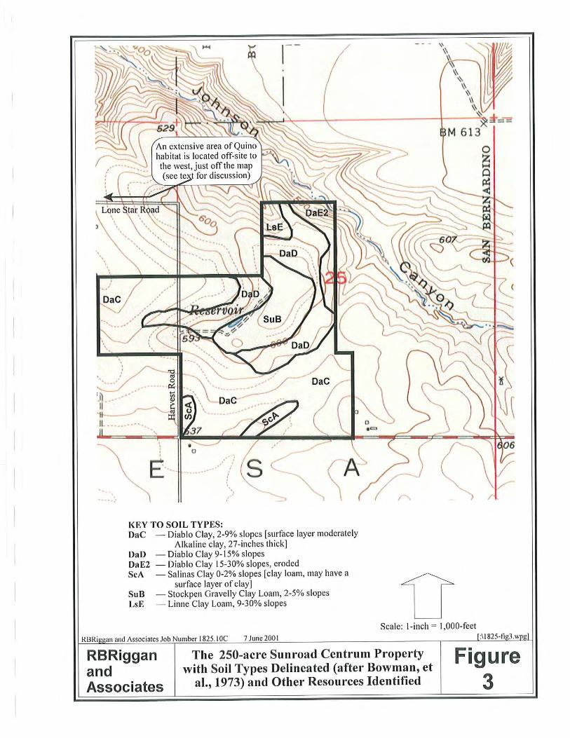
The underlying geology of the property is mapped as the Otay Formation (Todd, 2004).This mappingis consistent with the clay soils seen on the property. The surficial soils mapped by Bowman (1973)include the following: # Diablo clay, 15 to 30% slopes, eroded (DaE2);# Diablo clay, 9 to 15% slopes (DaD); # Stockpen gravelly clay loam, 2 - 5% slopes (SuB);# Linne clay loam, 9 to 30% slopes (LsE); and# Salinas clay, 0 to 2% slopes (ScA).
The vegetative communities found on the property can be classified into five types:
Non-Native Grassland. The majority of the site is occupied by Non-Native Grassland dominatedby a dense stand of Russian Thistle (Salsola tragus) combined with Oats (Avena fatua) and Mustards(Brassica nigra and Hirschfeldia incana). This habitat type is best described as Non-NativeGrassland (Holland, 1986; Holland Element Code 42200). There are composition variations withinthis habitat caused by different underlying soils and human disturbances. One of these variationsoccurs along the old Lone Star Road alignment. Although there is Russian Thistle in this area too,its growth is stunted allowing native species, such as the Dot-seed Plantain to grow.
Native Grassland. Two small patches of Native Grassland (Holland, 1986; Holland Element Code42100) occur in the northeastern portion of the property. Although interspersed with non-natives,dense native bunch grasses (Stipa lepida) dominate in this area.
Agriculture Stock Pond. An Agriculture Stock Pond occurs roughly in the middle of the property.The pond is now dry and is ringed with Russian Thistle.
Disturbed Habitat. Dirt trails traverse the property and are heavily used by off-road vehicles. Dueto the consistent, heavy use, no vegetation grows on these trails and, as such, these areas are bestclassified as Disturbed Habitat (Holland, 1986; Holland Element Code 11300).
Non-Native Riparian. Johnson Canyon crosses the extreme northeast corner of the site. The canyonis occupied by a Tamarisk grove (Tamarix sp.). Therefore, this area is best classified as Non-NativeRiparian habitat (Holland, 1986; Holland Element Code 65000).
III. Methods
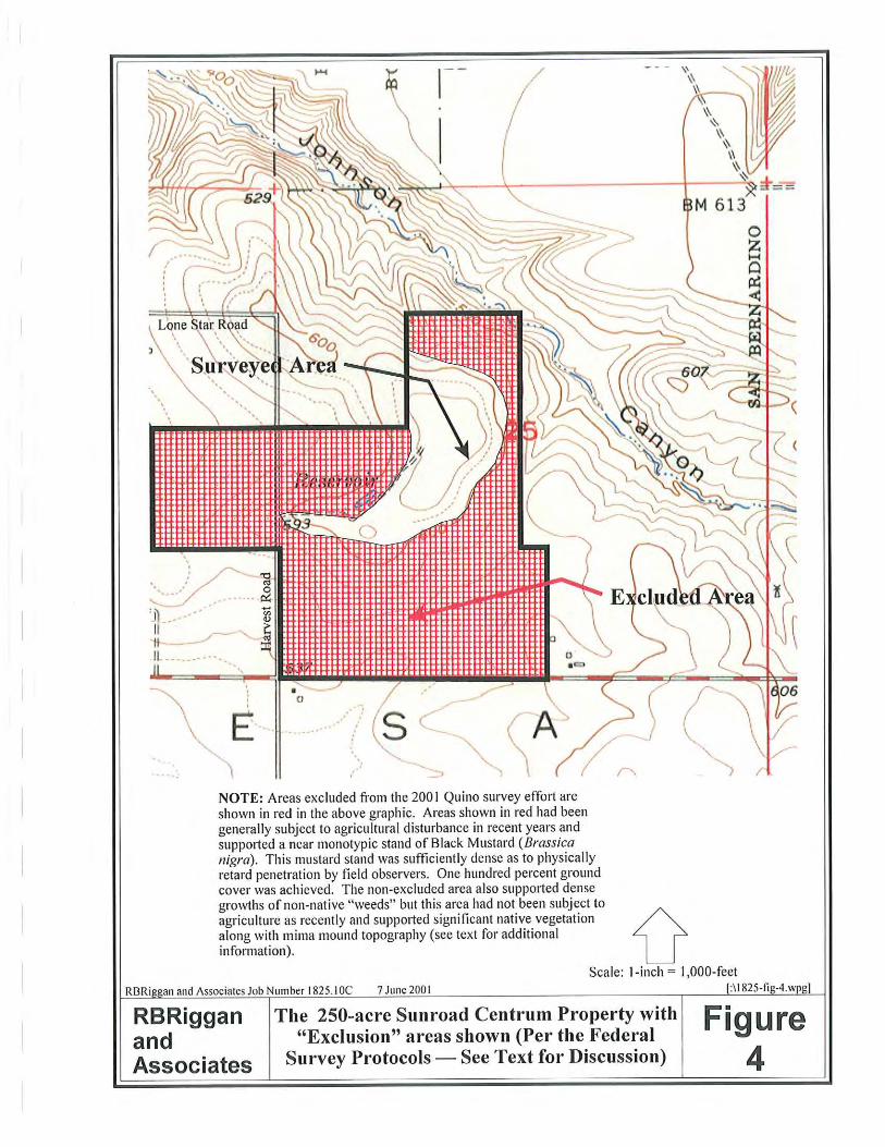
Per the 2016 Quino Checkerspot Butterfly Survey Protocol (USFWS, 2016), a site assessment wasconducted on 4 February 2016. The first portion of this site visit was dedicated to conducting the siteassessment and the section portion of the visit was allocated to an initial host plant survey. The
Page 5 of 6Cummings and Associates Job Number 1747.10C — Year 2016 Quino Survey Over the Sunroad Centrum 250 Property
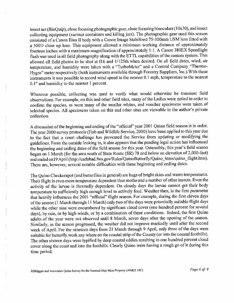
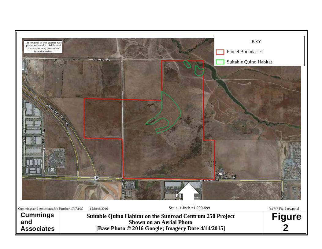
majority of the site was able to be excluded due to the occurrence of dense Russian Thistle and othernon-native plant species. The areas not excluded from the survey were considered suitable Quinohabitat (see Figure 2). On 1 May 2016, the site assessment was revised and the host plant mappingwas completed between 0900 and 1015 hours prior to the start of the first Quino survey whichoccurred between 1015 and1400 hours. Four subsequent visits were conducted representing theremainder of the Quino survey dates. During all survey efforts for the Quino Checkerspot, theundersigned was equipped with a collapsible insect net (BioQuip), close focusing photographic gear,and close focusing binoculars (8x42). The photographic gear used this season consisted of a NikonD300 body and a 70 - 300 mm Quantaray lens with a macro function. This equipment allowed aminimum working distance of approximately fourteen inches. During the six field dates, wind, andair temperature were taken with a Kestrel. With this instrument, it was possible to record wind speedto the nearest 0.1 mph, and temperature to the nearest 1°. Weather conditions at the beginning andending of each survey period were recorded and are presented in Table 1.
IV. Results
A total of six site visits were made to the Sunroad Centrum 250 property between 4 February and3 April. A medium density population of Dot-seed Plantain (Plantago erecta) was observed on-site(see Figure 3 for location). No larvae or adult Quino Checkerspot were observed on the propertyduring any of the six site visits.
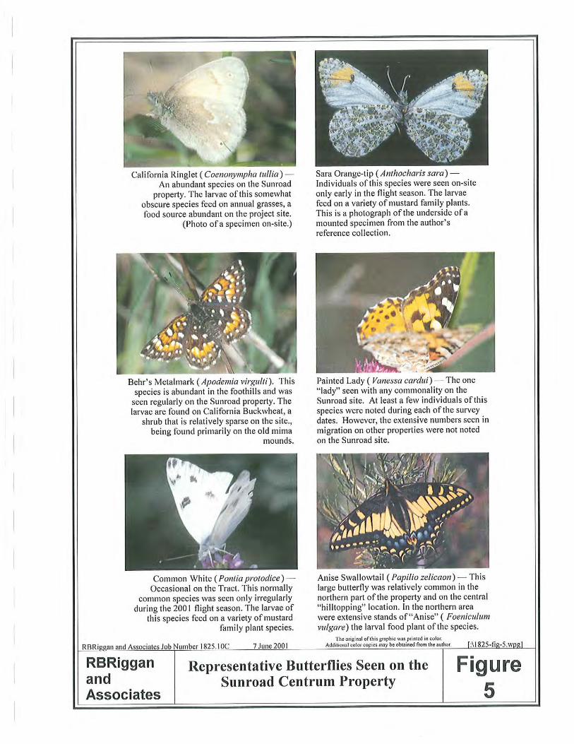
The following points highlight the results of the butterfly survey effort on the Sunroad Centrum 250property: # A total of 12 butterfly species were identified during the Quino survey (see Figure 4 for
photos of the representative butterfly species observed and Table 2 for a list of the butterflyspecies).
# Two butterfly species, the Western Pygmy-Blue and the Anise Swallowtail, were observedduring all six surveys.
A compilation of the butterflies observed during the protocol survey effort is presented as Table 2.The reader’s attention is directed to that table, to the attached Figure 4, and to the attached FieldNotes for additional information and details on the results of the field effort.
During the course of the survey, a concerted effort was made to identify other plant and wildlifespecies that would be considered sensitive. While this part of the field effort does not constitute acomprehensive survey, any observations of interest must be reported per the requirements of thefederal protocol for the Quino. No other sensitive species were noted within the suitable Quinohabitat.

Page 6 of 6Cummings and Associates Job Number 1747.10C — Year 2016 Quino Survey Over the Sunroad Centrum 250 Property
V. Recommendation
Although a medium density population of a Quino larval host plant was identified on-site, no larvaenor adults of the Quino Checkerspot were identified during the 2016 protocol survey. Therefore, anyproposed future development of the Sunroad Centrum 250 property will have no effect on theendangered Quino Checkerspot Butterfly. Absent a demonstrable effect on the species, no mitigationmeasures are required, and none are recommended.
VI. Surveyor Certification
I certify that the information in this survey report and attached exhibits fully and accuratelyrepresents my work. Any errors or omissions are solely my responsibility.
5/18/16 Gretchen Cummings DatePrincipal/Consulting Biologist[TE-031850-4]
[:\1747Quino-report.wpd]

The original of this graphic was produced incolor. Additional color copies may be
obtained from the author.
CummingsandAssociates
Figure1
[:\1747-Fig-1-rev.ppp]Cummings and Associates Job Number 1747.10C 26 February 2016
Sunroad Centrum 250 Project Shown on theU.S.G.S. 7 ½-minute Otay Mesa Quad Map
[Base Map Created with TOPO!® ©2006 National Geographic;©2005 TeleAtlas]
Scale: 1-inch = 2,000-feet
CummingsandAssociates
Figure2
The original of this graphic wasproduced in color. Additiona lcolor copies may be obta ined
from the author.
Cummings and Associates Job Number 1747.10C 1 March 2016 [:\1747-Fig-2-rev.pptx]
Suitable Quino Habitat on the Sunroad Centrum 250 ProjectShown on an Aerial Photo
[Base Photo © 2016 Google; Imagery Date 4/14/2015]
Scale: 1-inch =1,000-feet
KEY
Parcel Boundaries
Suitable Quino Habitat
The original of this graphic was produced incolor. Additional color copies may be
obtained from the author.
CummingsandAssociates
Figure3
[:\1747-Fig-3.ppp]Cummings and Associates Job Number 1747.10C 1 March 2016
Sunroad Centrum 250 Project Shown on theU.S.G.S. 7 ½-minute Otay Mesa Quad Map
[Base Map Created with TOPO!® ©2006 National Geographic;©2005 TeleAtlas]
Scale: 1-inch = 500-feet
KEY
Parcel Boundaries
Medium Density Plantago erecta Population

The original of this graphic was produced incolor. Additional color copies may be
obtained from the author.
CummingsandAssociates
Figure4
[:\1747-Fig-4.pptx]Cummings and Associates Job Number 1747.10C 18 May 2016
Representative Butterfly SpeciesNoted During the 2016 Quino Checkerspot
Butterfly Survey
Figure 4C —Gray Hairstreak (Strymon melinus)This butterlly species was seen during the last foursite visits. Larvae feed on plants in the Pea Family and Mallow Family [Photo taken on-siteduring the Quino survey.]
Figure 4A — Western Pygmy-Blue(Brephidium exile)This species was seen during all six survey dates. The larvae feed on Russian Thistle, Satlbushes, andothers.[Photo taken on-site during the Quino survey.]
Figure 4B — Anise Swallowtail (Papilio zelicaon)This species was observed during all six survey
dates. The larvae feed on Sweet Fennel. [Photo taken on-site during the Quino survey.]
Figure 4D — White Checkered-Skipper(Pyrgus albescens)
This species was seen during four of the fiveQuino surveys. The larvae of this species feed ona variety of Mallow Family plant species. [Photo
taken on-site during the Quino survey.]

Page 1 of 1
Table 1
Summary of Weather Conditions at theTime of the Individual Survey Dates
Sunroad Centrum 250 Property
Survey Date Beginning of Observation Period End of Observation Period
Time CloudCover
Wind AirTemp
Time CloudCover
Wind AirTemp
Site Assessment andInitial Host Plant
Mapping
4 Feb 0930 Clear < 1.2 mph 61.3°F 1340 Clear 2.4 - 4.1 mph 73.8°F
Finalize Host PlantMapping
1 Mar 0900 30% < 1.3 mph 67.5°F 1015 30% < 2.0 mph 73.1°F
Quino Survey #1 1 Mar 1015 30% < 2.0 mph 73.1°F 1400 40% 1.9 - 8.1 mph 73.8°F
Quino Survey #2 8 Mar 1000 Clear 2.8 - 4.8 mph 60.1°F 1330 Clear 5.9 - 8.3 mph with gusts to
11.4 mph
65.1° F
Quino Survey #3 18 Mar 1355 Clear 4.8 - 8.4 mph 71.9°F 1555 Clear 3.9 - 8.7 mph 73.4°F
Quino Survey #4 24 Mar 1330 Clear 7.0 - 11.5 mph 79.7°F 1530 Clear 4.1 - 9.1 mph 79.5°F
Quino Survey #5 3 Apr 1430 20% 4.3 - 8.3 mph 73.5°F 1630 30% 3.7 - 7.2 mph 74.2°F
[:\1747weather-tbl.wpd]

Page 1 of 2
Table 2
Summary of the Butterfly Species Observed at the Sunroad Centrum 250 PropertyCounty of San Diego, California
Scientific Name /1
Common Name4
Feb2, 31
Mar31
Mar38
Mar18
Mar24
Mar3
AprAnthocharis saraSara Orangetip
— — — — 1 1 —
Brephidium exileWestern Pygmy-Blue
2 1 22 13 7 2 2
Colias sp.Sulphur
— — 2 — — — —
Colias eurythemeOrange Sulphur
— — — — — — 1
Erynnis funeralisFunereal Duskywing
— — 1 1 2 — 1
Papilio zelicaonAnise Swallowtail
2 1 8 4 4 1 3
Pieris rapaeCabbage White
— — 1 — — — —
Pontia protodiceCheckered White
— — — — 2 — —
Pyrgus albescensWhite Checkered-Skipper
— — 1 3 — 2 1

Scientific Name /1
Common Name4
Feb2, 31
Mar31
Mar38
Mar18
Mar24
Mar3
Apr
Page 2 of 2
Strymon melinusGray Hairstreak
— — — 1 1 1 3
Vanessa annabellaWest Coast Lady
— — — 2 1 — 1
Vanessa cardui Painted Lady
— — — 1 — — —
Vanessa virginiensisAmerican Lady
— — — — — — 5
Undifferentiated White — — — — — 1 4
Total Individuals/Total Species Observed
4/2
2/2
35/6
25/7
18/7
8/6
21/9
For a discussion of the identification and species observed, see text. Nomenclature taken from:1
Cassie, Brian, J. Glassberg, A. Swengel, and G. Tudor. 2001. North American Butterfly Association (NABA) Checklist & English Names of North American Butterflies. Second Edition. NorthAmerican Butterfly Association, Inc., Morristown, NJ, 60 pp.
The first part of this site visit was the “site assessment” according to the Proposed 2016 Quino Checkerspot Survey Protocol.2
The latter part of the 4 February 2016 site visit was spent looking for host plants. The first part of the 1 March 2016 site visit was spent finalizing the host plant mapping. The second part of the 13
March 2016 visit was the first Quino survey.
[:\1747bug-tbl.wpd]

Appendix A
Field Notes
Page 1 of 5
2016 Field Notes for the Quino Surveyover the Sunroad Centrum 250 Property in Otay Mesa
4 February 2016
A Quino Checkerspot Butterfly habitat assessment and initial host plant survey was conductedover the Sunroad Centrum 250 property today (Cummings and Associates Job #1747.10C). Thefield survey occurred between 0930 and 1340 hours. The sky was sunny and clear throughout thesite visit. The temperature rose during the survey period from 61.3°F at 0930 hours to 73.8°F at1340 hours. Wind speeds were measured at < 1.2 mph at the beginning of the survey. At thecompletion of the visit, wind speeds were measured between 2.4 - 4.1 mph. Butterfly speciesobserved during the habitat assessment and initial host plant survey were:Brephidium exile (2)Papilio zelicaon (2)
The only Quino host plant identified on-site was Dot-seed Plantain (Plantago erecta). A mediumdensity population was noted along the old Lone Star Road alignment.
1 March 2016
The first part of today’s visit was dedicated to finishing the Quino host plant mapping over theSunroad Centrum 250 property (Cummings and Associates Job #1747.10C). This field workoccurred between 0900 and 1015 hours. The sky was partly cloudy with 30% high cloud coverthroughout the survey. Temperature increased from 67.5°F at 0900 hours to 73.1°F at 1015hours. Wind speeds were measured at < 1.3 mph at the onset of the survey and at < 2.0 mph atthe end.
Butterflies observed were:Papilio zelicaon (1)Brephidium exile (1)
The second part of today’s survey represented the first of the protocol Quino surveys over theSunroad Centrum 250 property (Cummings and Associates Job #1747.10C). The protocol surveyoccurred between 1015 and 1400 hours. The ambient temperature increased slightly from 73.1°Fat the onset of the field visit to 73.8°F at the end of the survey. The wind was blowing from thewest during the observation period. Wind speeds were measured at < 2.0 mph at the beginning ofthe visit and between 1.9 - 8.1 mph at the end of the survey. The sky was partly cloudy with 30%cloud cover at 1015 hours and 40% cloud cover at 1400 hours. Butterflies observed were:

Page 2 of 5
Colias sp. (2)Pyrgus albescens (1) Erynnis funeralis (1)Brephidium exile (22)Pieris rapae (1)Papilio zelicaon (8)
Nectaring sources included:Erodium spp.Dichelostemma capitatumSidalcea malvifloraCalystegia macrostegiaLasthenia californica Plantago erectaAcmispon glaberAllium praecox Peritoma arboreaSisyrinchium bellumCalochortus splendensHedypnois creticaNOTE: The only flowering plant in the Non-Native Grassland area was Dichelostemmacapitatum.
8 March 2016
The second Quino protocol survey was conducted over the Sunroad Centrum 250 property today(Cummings and Associates Job #1747.10C). This second survey was conducted between 1000and 1330 hours. The sky was sunny and clear throughout the survey. The temperature increased from 60.1°F at 1000 hours to 65.1°F at 1330 hours. Winds were blowing from the northwest atspeeds between 2.8 - 4.8 mph at 1000 hours. At the end of the survey, the winds were blowingfrom the west, and were measured between 5.9 - 8.3 mph with gusts up to 11.4 mph. Butterflyspecies observed during this second protocol survey were:Papilio zelicaon (4)Brephidium exile (13)Erynnis funeralis (1)Pyrgus albescens (3)Strymon melinus (1)Vanessa annabella (2) Vanessa cardui (1)

Page 3 of 5
Nectaring sources included:Dichelostemma capitatumBrassica nigraSidalcea malvifloraCalystegia macrostegiaLasthenia californica Plantago erectaAllium praecox Peritoma arboreaSisyrinchium bellumCalochortus splendensThe Plantago erecta was still flowering, but some were starting to yellow.
Other observations included two Coyotes (Canis latrans) laying down together in the man-made“wetland”.
18 March 2016
Today the third of the required Quino protocol surveys was conducted over the Sunroad Centrum250 property (Cummings and Associates Job #1747.10C). The field visit occurred between 1355and 1555 hours. The sky was sunny and clear throughout the survey. Ambient temperatures weremeasured at 71.9°F at the onset of the visit and at 73.4°F at the end of the observation period. Atthe beginning of the survey, the wind was blowing from the west at speeds ranging from 4.8 - 8.4mph. By the end of the visit, the winds were still blowing from the west, and were measuredbetween 3.9 - 8.7 mph. Butterfly species observed during this visit were:Papilio zelicaon (4)Pontia protodice (2)Erynnis funeralis (2)Brephidium exile (7)Anthocharis sara (1)Vanessa annabella (1)Strymon melinus (1)
Nectaring sources during this visit included:Hirschfeldia incanaMedicago polymorpha Dichelostemma capitatumCalochortus splendensCalystegia macrostegia

Page 4 of 5
Sisyrinchium bellumLasthenia californica Sidalcea malvifloraPlantago erectaAcmispon glaberAllium praecox Some of the Plantago erecta was still green and flowering, but some has started to dry. Plantsvaried in height up to 2".
24 March 2016
Today the fourth of the required Quino protocol surveys was conducted over the SunroadCentrum 250 property (Cummings and Associates Job #1747.10C). The field visit occurredbetween 1330 and 1530 hours. The sky was sunny and clear throughout the survey. Ambienttemperatures were measured at 79.7°F at 1330 hours and at 79.5°F at 1530 hours. At thebeginning of the survey, the wind was blowing from the west at speeds ranging from 7.0 - 11.5mph. By the end of the visit, the winds were blowing from the west at speeds ranging from 4.1 -9.1 mph. Butterfly species observed during this visit were:Pyrgus albescens (2)Papilio zelicaon (1)
Undifferentiated White (1)Brephidium exile (2)Anthocharis sara (1)Strymon melinus (1)
Nectaring sources during this visit included:Brassica nigraCalystegia macrostegiaCalochortus splendensSisyrinchium bellumDichelostemma capitatumAllium praecox Lasthenia californica Plantago erectaAcmispon glaberMelilotus indicusNOTE: The only flowering plant in the Non-Native Grassland area was Brassica nigra.
Some of the Plantago erecta was still flowering, but definitely drying out.

Page 5 of 5
3 April 2016
Today the fifth of the required Quino protocol surveys was conducted over the Sunroad Centrum250 property between 1430 and 1630 hours (Cummings and Associates Job #1747.10C). The skywas partly cloudy throughout the survey with approximately 20% cloud cover at 1430 hours and30% cloud cover at 1430 hours. Temperatures ranged from 73.5°F at the onset of the visit to74.2°F at the end of the observation period. Wind speeds ranged between 4.3 - 8.3 mph from thewest at the beginning of the butterfly survey. At the end of the visit, wind speeds were measuredbetween 3.7 - 7.2 mph from the west. Butterfly species observed were:Papilio zelicaon (3)
Undifferentiated White (4)Strymon melinus (3)Vanessa virginiensis (5)Pyrgus albescens (1)Brephidium exile (2)Erynnis funeralis (1)Colias eurytheme (1)Vanessa annabella (1)
Nectaring sources during this visit included:Brassica nigraCalystegia macrostegiaCalochortus splendensBloomeria croceaSisyrinchium bellumEriogonum fasciculatumLasthenia californica Brodiaea jolonensisAcmispon glaberNOTE: The only flowering plants in the Non-Native Grassland area were Brassica nigra andCalystegia macrostegia.
All of the Plantago erecta was dried out.
The only other observation of note was a Coyote (Canis latrans).
[:\1747Field Notes.wpd]

Proposed 2016 Quino Checkerspot Survey Protocol
The intent of this proposed Quino Checkerspot Butterfly (QCB) protocol is to combine elements of past
U.S. Fish and Wildlife Service (FWS) protocols to use for the 2016 season (at a minimum). In order to do
this, the 2002, early 2014, and late 2014 protocols were used. To that end, reporting and required
survey areas remain the same as the December 2014 protocol. The protocol is as follows:
1.1 SITE ASSESSMENTS AND HOST PLANT MAPPING Site assessments involve conducting a general field survey of the site and mapping excluded
areas and QCB survey areas, as defined below, on a U.S. Geological Survey 7.5’ (1:24,000) topographic quadrangle map enlarged 200 percent.
The site assessment shall be conducted before the first QCB survey and prior to host plant mapping.
Excluded Areas not recommended for QCB surveys:
o Orchards, developed areas, or areas largely dominated by non-native vegetation; o Small in-fill parcels (plots smaller than an acre completely surrounded by urban
development); o Active/in-use agricultural fields without natural or remnant inclusions of native
vegetation or that are completely without any fallowed or unplowed areas; o Closed-canopy woody vegetation including forests, riparian areas, shrub-lands, and
chaparral. “Closed-canopy woody vegetation” describes shrubs or trees growing closely together in which the upper portions of the vegetation converge (are touching) to the point that the open space between two or more plants is not significantly different than the open space within a single plant. Closed canopy shrub-land and chaparral are defined as vegetation so thick that it is inaccessible to humans except by destruction of woody vegetation (branches) for at least 100 meters;
o Small openings (e.g., less than an acre) completely enclosed within dense chaparral provided a site-specific justification is included in the report.
QCB Survey Areas are all areas that are not excluded, regardless of the presence or absence of QCB host plants or nectar sources.
Upon completion of the site assessment, QCB Survey Areas will be surveyed for known host and nectar plants such as dwarf plantain (Plantago erecta), wooly plantain (Plantago patagonica), white snapdragon (Antirrhinum coulterianum), rigid bird’s beak (Cordylanthus rigidus) and/or Chinese houses (Collinsia concolor). All locations of host plants will be mapped with a GPS unit (or equivalent) and populations will be estimated to categorize density of host plant patches. For example, density categories could be: low density (1 - 100 plants), medium density (100 – 1,000 plants), and high density (1,000 – 10,000+ plants).

2.1 QUINO SURVEYS An appropriate reference population) will be surveyed on a weekly basis, starting the second
week of January, by a permitted biologist. For 2016, Marron Valley will be used as the reference
population, and it will be used to define the flight season for Management Units 3 (Janal) and 4
(Alisos) that is identified in the Management Strategic Plan for Western San Diego County
(http://sdmmp.com/reports_and_products/Management_Strategic_Plan.aspx). Different parts
of the QCB range may require different reference sites, and any reference sites chosen for other
parts of the range will be approved by the Service. Reference population(s) will be monitored by
only entities agreed up and approved by the Service. The purpose of this is to not overly sample
the habitat and potentially negatively affect the population.
o The monitoring biologist will assess the condition of host plants within the reference
population, and note any signs of egg, larva (caterpillar), pupa (chrysalis), and adult
butterflies.
o The monitoring biologist will note weather conditions at the reference site and, to the
extent feasible, monitoring days will be based on the weather conditions outlined in
Section 3.0.
o The biologist will work with the Service to make a reasonable effort to notify biologists
potentially planning to conduct focused surveys in 2016, of the weekly survey results.
This may occur by any means, including posting the results on a dedicated website or
other similar media.
QCB surveys shall not be conducted concurrently with any other focused survey (e.g. a coastal
California gnatcatcher or QCB host plant survey). However, additional host or nectar plants
observed during the survey effort should be mapped and quantified per Section 1.0.
The entire QCB Survey Area identified in Section 1.0 shall be surveyed for QCB each week.
Surveys shall be conducted weekly and spaced no closer than 4 calendar days apart (see Section
3.0 WEATHER- RELATED CONDITIONS).
Surveys shall be conducted for a minimum of 5 weeks and will be initiated within one week of
observed QCB flight at the reference site(s). It will be the surveyor’s responsibility to stay
informed of the reference site comparable to their specific project site. If no Quino are observed
in the first 5 weeks, surveys will continue until the flight season is over or demonstrably on the
decline in the reference site as determined in coordination with the surveyor and the Service.
Surveys should be conducted at a rate of approximately 5-10 acres (2-4 hectares) per person-
hour. Survey rate can depend on topography and other physical factors at the survey site. A full
description of the QCB Survey Area should be provided in the survey report, noting any
deviations from this specified survey rate.
Survey routes shall be roughly parallel to each other and spaced approximately 30 feet (10
meters) apart.
Survey routes shall cover within 15 feet (5 meters) of site boundaries and/or the perimeter of

excluded areas.

3.1 WEATHER-RELATED CONDITIONS Surveys will not be conducted when the following weather conditions exist:
o Fog, drizzle, or rain;
o Sustained or gusting winds that average greater than 15 miles (24 kilometers) per hour
measured over a 30 second period at a height of 4-6 feet (1.2-1.8 meters) above ground
level;
o Temperature in the shade at ground level is less than 60o F (15.5o C) on a clear, sunny
day with less than 50 percent cloud cover, or less than 70o F (21o C) on days with 50
percent or more cloud cover;
Weather conditions are to be measured on site, using appropriate instrumentation, and are not
to be estimated or obtained from internet websites where measurements are recorded off site;
A weekly survey should only be missed because of week-long adverse weather. If a weekly
survey is missed due to weather conditions, two surveys should be conducted on non-
consecutive days the following week.