queen elizabeth park master plan | city of edmonton 2013 · 57 queen elizabeth park master plan |...
TRANSCRIPT

Queen Elizabeth Park Master Plan | City of Edmonton 2013
55
04 core DeSign StrategieS

56
4.1 viSion, MiSSion anD guiDing principleSQueen Elizabeth Park’s vision statement describes a desired future state of the park that will result if the goals of the park master plan are achieved. a vision statement is bold, descriptive, and should inspire citizens to get involved in helping to realize this future state. an effective vision statement can help guide decisions for the future development of the park.
in contrast, the mission statement for Queen Elizabeth describes the park’s purpose within the overall river valley system of parks and who the target users are for the park.
from discussions with City of Edmonton staff, key stakeholders, aboriginal community members, and the wider public, a vision and mission for Queen Elizabeth Park began to emerge. this was complemented with an understanding of the visions and goals for several related plans and initiatives (see “related Policy and initiatives” section above).
vIsIoN statEMENtQueen Elizabeth Park is a well-loved gathering place in the heart of Edmonton where people come to be active, connect with nature, and discover the rich cultural heritage of the river valley.
MIssIoN statEMENt
to provide a variety of ways for Edmonton residents and visitors to experience, understand, and connect to the river valley environment.
57
Queen Elizabeth Park Master Plan | City of Edmonton 2013
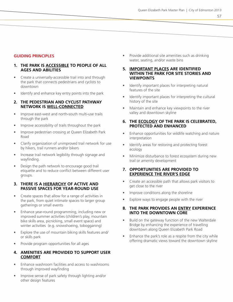
gUIDINg PrINCIPlEs
1. tHE Park Is aCCEssIblE to PEoPlE oF all agEs aND abIlItIEs
• Create a universally-accessible trail into and through the park that connects pedestrians and cyclists to downtown
• identify and enhance key entry points into the park
2. tHE PEDEstrIaN aND CyClIst PatHway NEtwork Is wEll-CoNNECtED
• improve east-west and north-south multi-use trails through the park
• improve accessibility of trails throughout the park
• improve pedestrian crossing at Queen Elizabeth Park road
• Clarify organization of unimproved trail network for use by hikers, trail runners and/or bikers
• increase trail network legibility through signage and wayfinding.
• design the path network to encourage good trail etiquette and to reduce conflict between different user groups.
3. tHErE Is a HIErarCHy oF aCtIvE aND PassIvE sPaCEs For yEar-roUND UsE
• Create spaces that allow for a range of activities in the park, from quiet intimate spaces to larger group gatherings or small events
• Enhance year-round programming, including new or improved summer activities (children’s play, mountain bike skills area, picnicking, small event space) and winter activities (e.g. snowshoeing, tobogganing)
• Explore the use of mountain biking skills features and/or skills park
• Provide program opportunities for all ages
4. aMENItIEs arE ProvIDED to sUPPort UsEr CoMFort
• Enhance washroom facilities and access to washrooms through improved wayfinding
• improve sense of park safety through lighting and/or other design features
• Provide additional site amenities such as drinking water, seating, and/or waste bins
5. IMPortaNt PlaCEs arE IDENtIFIED wItHIN tHE Park For sItE storIEs aND vIEwPoINts
• identify important places for interpreting natural features of the site
• identify important places for interpreting the cultural history of the site
• Maintain and enhance key viewpoints to the river valley and downtown skyline
6. tHE ECology oF tHE Park Is CElEbratED, ProtECtED aND ENHaNCED
• Enhance opportunities for wildlife watching and nature interpretation
• identify areas for restoring and protecting forest ecology
• Minimize disturbance to forest ecosystem during new trail or amenity development
7. oPPortUNItIEs arE ProvIDED to ExPErIENCE tHE rIvEr’s EDgE
• Create an accessible path that allows park visitors to get close to the river
• improve conditions along the shoreline
• Explore ways to engage people with the river
8. tHE Park ProvIDEs aN ENtry ExPErIENCE INto tHE DowNtowN CorE
• build on the gateway function of the new walterdale bridge by enhancing the experience of travelling downtown along Queen Elizabeth Park road
• Enhance the park’s role as a respite from the city while offering dramatic views toward the downtown skyline
58
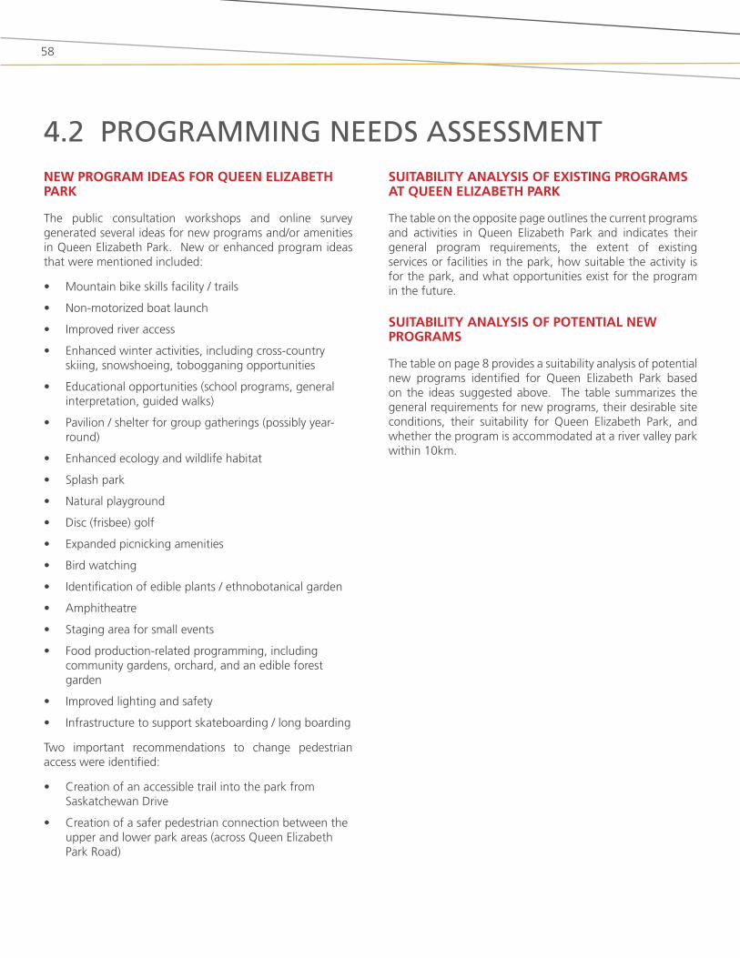
4.2 prograMMing neeDS aSSeSSMentNEw PrograM IDEas For QUEEN ElIzabEtH Park
the public consultation workshops and online survey generated several ideas for new programs and/or amenities in Queen Elizabeth Park. new or enhanced program ideas that were mentioned included:
• Mountain bike skills facility / trails
• non-motorized boat launch
• improved river access
• Enhanced winter activities, including cross-country skiing, snowshoeing, tobogganing opportunities
• Educational opportunities (school programs, general interpretation, guided walks)
• Pavilion / shelter for group gatherings (possibly year-round)
• Enhanced ecology and wildlife habitat
• splash park
• natural playground
• disc (frisbee) golf
• Expanded picnicking amenities
• bird watching
• identification of edible plants / ethnobotanical garden
• amphitheatre
• staging area for small events
• food production-related programming, including community gardens, orchard, and an edible forest garden
• improved lighting and safety
• infrastructure to support skateboarding / long boarding
two important recommendations to change pedestrian access were identified:
• Creation of an accessible trail into the park from saskatchewan drive
• Creation of a safer pedestrian connection between the upper and lower park areas (across Queen Elizabeth Park road)
sUItabIlIty aNalysIs oF ExIstINg PrograMs at QUEEN ElIzabEtH Park
the table on the opposite page outlines the current programs and activities in Queen Elizabeth Park and indicates their general program requirements, the extent of existing services or facilities in the park, how suitable the activity is for the park, and what opportunities exist for the program in the future.
sUItabIlIty aNalysIs oF PotENtIal NEw PrograMs
the table on page 8 provides a suitability analysis of potential new programs identified for Queen Elizabeth Park based on the ideas suggested above. the table summarizes the general requirements for new programs, their desirable site conditions, their suitability for Queen Elizabeth Park, and whether the program is accommodated at a river valley park within 10km.

59
Queen Elizabeth Park Master Plan | City of Edmonton 2013
CUrrENt PrograMs / aCtIvItIEs
gENEral PrograM rEQUIrEMENts
ExIstINg sErvICEs / FaCIlItIEs at QUEEN
ElIzabEtH Park
sUItabIlIty oF PrograM For
QUEEN ElIzabEtH Park
oPPortUNItIEs For FUtUrE Park PrograMMINg
walkINg / rUNNINg (PavED traIls)
Paved trail with accessible grades, well-connected
Major east-west multi-use paved trail, stair access to saskatchewan drive.
walking / running is a popular activity in the park and is well-suited for Queen Elizabeth Park. new trail development should minimize disturbance to existing forest where possible.
Users would benefit from universally-accessible trail connections to/from saskatchewan drive. additional accessible trail connections can be added to improve circulation and park access.
HIkINg / traIl rUNNINg (UNPavED/UNIMProvED traIls)
variety of trail experiences and terrain characteristics. trail guidelines or design features should be used to reduce conflict between different user groups. this can be done by providing networks that adequately support desired circulation patterns and demand, and that encourage trail etiquette.
there is a network of unofficial single-track trails throughout the upper and lower parks that are used for hiking, trail running, and mountain biking. trails take advantage of the site’s varying topography.
Hiking / trail running on unpaved/unimproved trails can be compatible with Queen Elizabeth Park. trail design should be low-impact.
there is an opportunity to formalize the network of secondary trails and improve trail standards to reduce any negative impacts on the forest.
CoMMUtEr aND rECrEatIoNal CyClINg (PavED traIls)
Paved trail with accessible grades, well-connected
Major east-west multi-use paved trail connects nellie McClung Park (east) and kinsmen Park (west). access from strathcona neighbourhood is difficult. there is no trail connection along Queen Elizabeth Park road. access from saskatchewan drive into the park is available from three staircases (one equipped with a ramp) and from 91st ave, through the lavigne area.
the park’s location is highly conducive to supporting commuting cyclists who travel between strathcona and downtown. new trail development should minimize disturbance to existing forest where possible.
there is an opportunity for better and safer north-south cycling routes through the park, particularly to support bike commuters who travel between strathcona and downtown.
MoUNtaIN bIkINg (UNPavED/UNIMProvED traIls)
variety of trail experiences and terrain characteristics. trail guidelines or design features should be used to reduce conflict between different user groups.
there is a network of unofficial single-track trails throughout the upper and lower parks that are used for hiking, trail running, and mountain biking. trails take advantage of the site’s varying topography.
Mountain biking is a popular activity in the park and there appears to be a good degree of public support for the activity. secondary / mountain bike trail design should be low impact to reduce erosion and tree damage.
there is an opportunity to formalize the network of secondary trails and improve trail standards to reduce any negative impacts on the forest. opportunities may exist to engage mountain biking clubs with trail building and stewardship.
sUItabIlIty aNalysIs oF ExIstINg PrograMs at QUEEN ElIzabEtH Park

60
CUrrENt PrograMs / aCtIvItIEs
gENEral PrograM rEQUIrEMENts
ExIstINg sErvICEs / FaCIlItIEs at QUEEN
ElIzabEtH Park
sUItabIlIty oF PrograM For
QUEEN ElIzabEtH Park
oPPortUNItIEs For FUtUrE Park PrograMMINg
PICNICkINg formal picnic areas include picnic tables and wood or briquette stoves/barbecues. some picnic sites should be wheelchair accessible. informal picnic areas should be well drained and have appropriate surfacing (e.g. lawn). waste bins and recycling bins could be situated nearby.
approx. 25 picnic sites, each equipped with picnic table and some have stoves / barbecues.
Picnicking is a well-loved activity that has a long tradition in the park, and there is an interest by the public in doing more picnicking in the park. Picnicking is a low impact activity that is well-suited to happen in its existing location.
there may be opportunities to increase the number of picnic areas, and/or to diversify the areas available for picnicking.
CaNaDa Day FIrEworks
Queen Elizabeth Park road and walterdale Hill rd are closed from 9:35-10:45pm on july 1st for Canada day fireworks.
views of the river valley and downtown, spectators access site from all sides on foot when streets are closed to vehicular traffic
Park has ample capacity and open spaces with views of fireworks and is a popular place to watch them from
there is an opportunity to improve the quality and flexibility of open space with unobstructed views of the river valley and downtown
Cross CoUNtry MoUNtaIN bIkE raCEs
loop track between walterdale br. and old timers’ Cabin primarily on single-track trails with a small portion of gravel trail, and along lavigne road/90 avenue. start/finish on multi-use path northeast of washroom building.
single track trails, multi-use trails, washrooms, parking for loading/unloading team vehicles with tents/equipment. Participant parking in upper park.
bike races utilize existing linear single track trail system for 1-3 events per year. some disturbance to regular park users during race events due to increased traffic and restricted trail use.
by ensuring that sufficient circulation options are provided, inconvenience to regular park users during race events may be reduced.
ENjoyINg vIEws oF rIvEr vallEy aND DowNtowN
vantage points and seating areas.
there are many informal viewpoints to the river valley and downtown from saskatchewan drive, Queen Elizabeth Park road, and dantzer’s Hill. formal views from saskatchewan drive entry points are partially obscured by forest.
formal and informal view points with seating are highly suitable for Queen Elizabeth Park.
trails, seating nodes and viewpoints within the park and along saskatchewan drive can be developed to take advantage of viewpoints to the river valley and downtown.
tablElaNDs grEEN sHaCk PrograM (storagE)
storage for green shacks (~10’ x 10’) outside of summer program season
15 - 27 green shacks are stored in the existing Queen Elizabeth Park Compound outside of the summer season (~150 to 250 m2)
Green shacks are not used for programming in Queen Elizabeth Park. the park does offer a desirable central location for Parks storage, however this may not be the best use of Queen Elizabeth Park.
since green shacks serve tablelands parks programming, it has been suggested that the storage of green shacks might be more suitable on tablelands.

61
Queen Elizabeth Park Master Plan | City of Edmonton 2013
CUrrENt PrograMs / aCtIvItIEs
gENEral PrograM rEQUIrEMENts
ExIstINg sErvICEs / FaCIlItIEs at QUEEN
ElIzabEtH Park
sUItabIlIty oF PrograM For
QUEEN ElIzabEtH Park
oPPortUNItIEs For FUtUrE Park PrograMMINg
boat storagE large, flat area that is accessible by vehicle for transportation to and from a boat launch. desirable to be close to a boat launch location. secured area to reduce theft and vandalism.
Ceyana Canoe Club and Edmonton dragon boat festival association have license agreements with the City to accommodate boat storage. Ceyana Canoe Club license area includes a 2-bay garage.
boat storage occurs at Queen Elizabeth Park due to the park’s central location, although the boats are not used for programming in the park. ideally boat storage is located within the vicinity of launch sites.
new walterdale bridge development requires realignment of existing access road. Potential for vehicular/pedestrian conflict depending on alternative new access road development.
the steep riverbank at Queen Elizabeth Park hinders access. a number of physical changes to the riverbank have happened in the last 20 years which have hindered the development of a permanent hand launch or dock. ideally boat storage is accommodated in areas with unhindered vehicular access and in proximity to launch sites.
rIvEr vallEy PrograMMINg (arCHEry, low roPEs)
archery requires a clear, flat area with controlled access to ensure public safety. area behind archery targets requires man-made or natural barricade or backing.
low ropes course requires a group of spaced posts, connected with ropes.
designated drop-off and parking for school buses with trail connections to program area, within a walkable distance.
located within a fenced compound approximately 1 ha in size. two ‘Green shacks’ for storage - one for each program.
brings approximately 4000 youth to the park annually for outdoor team-building activities
Potential to relocate the facilities to a location in the park with nicer surroundings that is more integrated with other uses in the park.
PlaygroUND spaces designed/designated for children to play, buffered from traffic, easily accessible, variety of play opportunities with consideration for all ages and abilities
small, dated playground near east end of park, forests and open grass areas
Potential to increase opportunities for play and other physical activity for all ages and in all seasons
Enhanced spaces that support children’s cognitive, social and motor skills development should be well-integrated throughout the park.
62
NEw PrograM / aCtIvIty IDEas
gENEral PrograM
rEQUIrEMENts
DEsIrablE sItE CoNDItIoNs
sUItabIlIty oF PrograM For
QUEEN ElIzabEtH Park
NEarby Parks wItH sIMIlar
PrograM
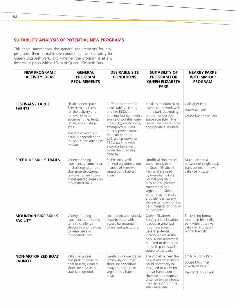
FEstIvals / largE EvENts
flexible open space. service road access for the delivery and removal of event equipment (i.e. tents, tables, chairs, stage, etc.)
the size of events in parks is dependent on the space and amenities available.
buffered from traffic, picnic tables, seating and fire bbQs, a drinking fountain with a source of potable water (hose bib), washrooms, emergency blufone, a 220v power source that can be fitted with a step-down to 110v, parking within a comfortable walk, wheelchair parking close by.
small to medium sized events could work well in the park depending on the flexible open space available. the largest events are more appropriate elsewhere.
Gallagher Park
Hawrelak Park
louise Mckinney Park
FrEE rIDE skIlls traIls variety of riding experiences, some areas of challenging terrain, challenge structures, features to keep users in designated areas / on designated trails.
stable soils, well-drained conditions, not in areas of sensitive vegetation / habitat areas.
Unofficial single track trails already exist at Queen Elizabeth Park and are used by mountain bikers. formalizing trails may help to protect topography and vegetation. steep terrain may be easily erodible, particularly in the eastern parts of the park. vegetation should be protected.
Multi-use and a network of single track trails connect the river valley park system.
MoUNtaIN bIkE skIlls FaCIlIty
variety of riding experiences, including terrain, challenge structures and features to keep users in designated areas.
located on a previously-disturbed site with access for mountain bikers and spectators.
Queen Elizabeth Park’s central location is popular amongst mountain bikers. several potential locations exist in the park. More research is required to determine if a skills park is well-suited to the park.
there is no formal mountain bike skills park within the river valley or, at present, within the City.
NoN-MotorIzED boat laUNCH
vehicular access and parking close to boat launch, cleared shoreline area with stabilized ground.
Gentle shoreline grades, previously-disturbed shoreline conditions away from sensitive vegetation / habitat areas.
the shoreline near the new walterdale bridge could potentially be designed to allow for a boat hand launch. However, the required distance to carry boats may detract from the site’s suitability.
Emily Murphy Park
louise Mckinney riverfront Park
Henrietta Miur Park
sUItabIlIty aNalysIs oF PotENtIal NEw PrograMs
this table summarizes the general requirements for new programs, their desirable site conditions, their suitability for Queen Elizabeth Park, and whether the program is at any river valley parks within 10km of Queen Elizabeth Park.
63
Queen Elizabeth Park Master Plan | City of Edmonton 2013
NEw PrograM / aCtIvIty IDEas
gENEral PrograM
rEQUIrEMENts
DEsIrablE sItE CoNDItIoNs
sUItabIlIty oF PrograM For
QUEEN ElIzabEtH Park
NEarby Parks wItH sIMIlar
PrograM
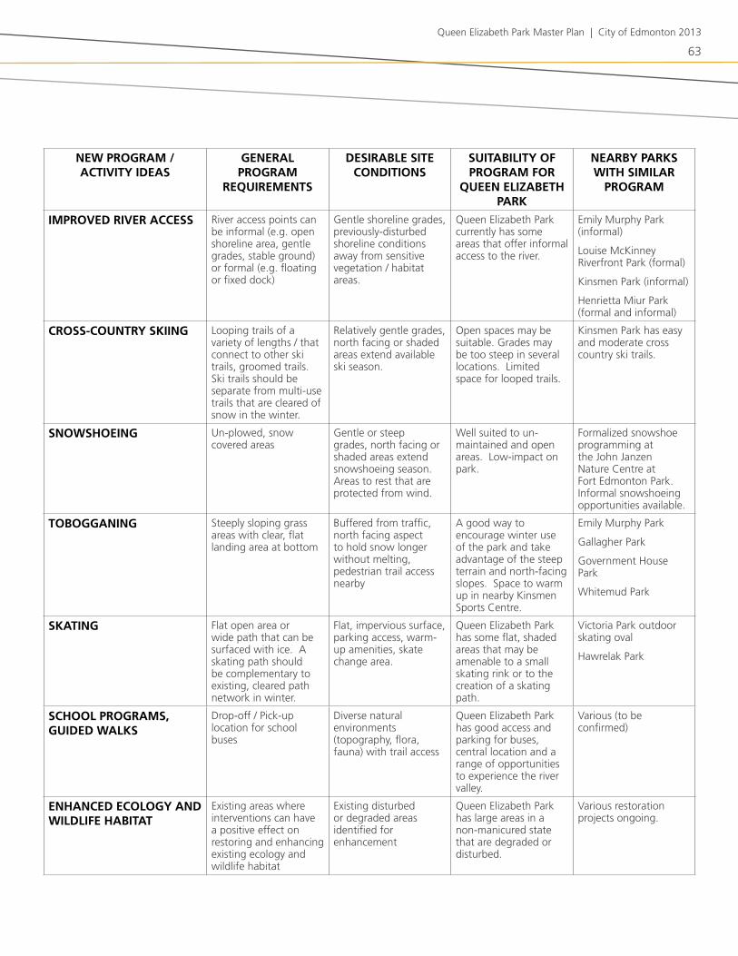
IMProvED rIvEr aCCEss river access points can be informal (e.g. open shoreline area, gentle grades, stable ground) or formal (e.g. floating or fixed dock)
Gentle shoreline grades, previously-disturbed shoreline conditions away from sensitive vegetation / habitat areas.
Queen Elizabeth Park currently has some areas that offer informal access to the river.
Emily Murphy Park (informal)
louise Mckinney riverfront Park (formal)
kinsmen Park (informal)
Henrietta Miur Park (formal and informal)
Cross-CoUNtry skIINg looping trails of a variety of lengths / that connect to other ski trails, groomed trails. ski trails should be separate from multi-use trails that are cleared of snow in the winter.
relatively gentle grades, north facing or shaded areas extend available ski season.
open spaces may be suitable. Grades may be too steep in several locations. limited space for looped trails.
kinsmen Park has easy and moderate cross country ski trails.
sNowsHoEINg Un-plowed, snow covered areas
Gentle or steep grades, north facing or shaded areas extend snowshoeing season. areas to rest that are protected from wind.
well suited to un-maintained and open areas. low-impact on park.
formalized snowshoe programming at the john janzen nature Centre at fort Edmonton Park. informal snowshoeing opportunities available.
toboggaNINg steeply sloping grass areas with clear, flat landing area at bottom
buffered from traffic, north facing aspect to hold snow longer without melting, pedestrian trail access nearby
a good way to encourage winter use of the park and take advantage of the steep terrain and north-facing slopes. space to warm up in nearby kinsmen sports Centre.
Emily Murphy Park
Gallagher Park
Government House Park
whitemud Park
skatINg flat open area or wide path that can be surfaced with ice. a skating path should be complementary to existing, cleared path network in winter.
flat, impervious surface, parking access, warm-up amenities, skate change area.
Queen Elizabeth Park has some flat, shaded areas that may be amenable to a small skating rink or to the creation of a skating path.
victoria Park outdoor skating oval
Hawrelak Park
sCHool PrograMs, gUIDED walks
drop-off / Pick-up location for school buses
diverse natural environments (topography, flora, fauna) with trail access
Queen Elizabeth Park has good access and parking for buses, central location and a range of opportunities to experience the river valley.
various (to be confirmed)
ENHaNCED ECology aND wIlDlIFE HabItat
Existing areas where interventions can have a positive effect on restoring and enhancing existing ecology and wildlife habitat
Existing disturbed or degraded areas identified for enhancement
Queen Elizabeth Park has large areas in a non-manicured state that are degraded or disturbed.
various restoration projects ongoing.

64
NEw PrograM / aCtIvIty IDEas
gENEral PrograM
rEQUIrEMENts
DEsIrablE sItE CoNDItIoNs
sUItabIlIty oF PrograM For
QUEEN ElIzabEtH Park
NEarby Parks wItH sIMIlar
PrograM
sPlasH Park a high visibility location with convenient access
Existing infrastructure in place (water, sewer, parking) and complementary programming activities that support high attendance numbers.
not well suited to Queen Elizabeth Park
kinsmen Park
NatUral PlaygroUND Environments that provide opportunities for open-ended play and interaction with nature.
buffered from traffic, central location with convenient access, trees, nearby neighbourhoods with families
lots of existing trees and forested areas, topography, views, picnic areas, multi-use paths and history as a family destination. Potential to enhance play opportunities in all seasons.
none known
DIsC (FrIsbEE) golF targets, tee pads signage, topography and safety
Under utilized parts of parks where possibility of points of interaction with non-players is minimized.
the areas of the park most suited for disc golf are also those most suited to other activities, potentially leading to conflict and safety concerns between user groups.
rundle Park
EtHNobotaNICal garDEN
indigenous and culturally-significant plant species with traditional uses as medicines, food, or as materials for fabrication or ceremonial purposes
vegetated areas near pedestrian paths to provide opportunities for interpretation.
as traditional territory of the Cree and blackfoot first nation, the park is in a culturally significant area of the river valley. an ethnobotanical garden is an appropriate way of acknowledging the history of the site and the aboriginal use of native plants.
none known
aMPHItHEatrE a natural formation shaped into a semicircular tiered seating area for viewing performances or other activities
semi-circular tiered slope with an interesting background view.
the regrading of dantzer’s Hill for the construction of the new walterdale bridge provides an opportunity for shaping the space into an amphitheatre
Hawrelak Park
FooD ProDUCtIoN, INClUDINg CoMMUNIty garDENs, orCHarD, EDIblE ForEst garDEN
depending on the program, requirements may include some or all of the following: sun, water, gardening tools, compost, passive surveillance, and a central, accessible location, community initiative to establish and maintain gardens.
varies depending on program.
City policy does not currently allow food production to take place in the river valley.
various community gardens located in neighbourhood parks (non-river valley)
i.e. strathcona rail (105th st between 85th and 86th ave)

65
Queen Elizabeth Park Master Plan | City of Edmonton 2013
NEarby rIvEr vallEy Parks /
aPProx. DrIvINg DIstaNCE FroM
QUEEN ElIzabEtH Park
IMPr
ov
ED t
ra
Ils
UN
IMPr
ov
ED t
ra
Ils
PIC
NIC
sIt
Es
wIN
tEr
IzED
w
asH
ro
oM
s
Ha
ND
bo
at
laU
NC
H
Pla
y a
rEa
tob
og
ga
NIN
g
xC
sk
IINg
sNo
wsH
oEI
Ng
ICE
ska
tIN
g
sPo
rts
FIE
lDs
Poo
l /
sPr
ay
Pa
rk
Co
vEr
ED g
ro
UP
/
PIC
NIC
sH
EltE
r
Co
NC
EssI
oN
blD
g
INFo
rM
al
oPE
N s
PaC
E
rIv
Er a
CC
Ess
otHEr
QUEEN ElIzabEtH Park • • • • • • • • • •
Unofficial skiing / snowshoeing / tobogganing / river access
kINsMEN Park (<500 M) • • • • • • • • • Pitch and Putt, museum
NEllIE MCClUNg Park
(<500 M)• •
MIll CrEEk ravINE Park (1 kM) • • • • • • •
vICtorIa Park (3 kM)
• • • • • • • •
Golf course adjacent, ball diamond, pitch and putt, cricket oval, horseshoes, pavilion planned, six reservable group picnic sites
EMIly MUrPHy Park (3 kM) • • • • • • • • • • two reservable group
picnic sites
HENrIEtta MUIr EDwarDs Park / gallagHEr Park
(3 kM)
• • • • • •Muttart Conservatory, Edmonton ski club, riverboat launch, festival site
HawrElak Park (4 kM) • • • • • • • • • • • •
Golf course adjacent, paddle boating, amphitheatre, five reservable group picnic sites, festival site
govErNMENt HoUsE Park (4 kM) • • • •
loUIsE MCkINNEy Park (4 kM) • • • • • • • •
Public dock, performance stage, riverfront plaza with future amenities / concession planned
wHItEMUD Park (5 kM) • • • • • • • Equestrian centre and trails
Fort EDMoNtoN Park
(6 kM)• • • • • Paid admission required
for museum facilities
bUENa vIsta / wIlFrID laUrIEr
Parks (10 kM)
• • • • • • • • • • •trailered boat launch, fishing area, horseshoe pits, picnic site reservations available
INvENtory oF aMENItIEs aND PrograMs at NEarby Parks

Queen Elizabeth Park Master Plan | City of Edmonton 2012
66
Queen Elizabeth Park Master Plan | City of Edmonton 2013
67
05 preliMinary DeSign conceptS
two preliminary design concepts were developed for Queen Elizabeth Park based on information gathered in the disCovEr phase, and based on the park vision, mission and guiding principles that were derived from this information. Public review and input on these concepts will inform the selection of a preferred approach for the park master plan.

68
ovErall INtENt
the overall intent of Concept 1 (figure 5.1) is to create a quiet, natural setting close to the river’s edge, where people can enjoy informal recreation in the large open field, or discover traditional uses of native plants at the ethnobotanical garden. the field and adjacent slope can also accommodate the occasional small event and winter activities. More active uses (bike skills area, river valley Programming) are placed in the upper park by the old Queen Elizabeth Pool and picnic area, where they are easily accessed by existing parking and a new path along fort Hill road.
kEy FEatUrEs oF CoNCEPt 1
Park aCCEss
• new multi-use trail along fort Hill road, beneath saskatchewan drive. this route would be quite steep (15% slope) but would not require stairs.
• Potential new multi-use trail along Queen Elizabeth Park road with moderate grades (8% slope). this path would require rebuilding part of Queen Elizabeth Park road, which would impact adjacent slopes and vegetation.
trEatMENt oF DaNtzEr’s HIll
• new large open field to accommodate a range of activities year-round. a slope connects the south end of the field to Queen Elizabeth Park road, providing a lookout point and tobogganing hill in the winter.
bIkE skIlls arEa
• new bike skills area in the upper park at the site of the old Queen Elizabeth Pool. this site would have convenient access from the existing parking lot and, as a previously developed site, it avoids new disturbance to natural areas.
sINglE traCk traIls
• new single track trails are built and existing trails are upgraded in the upper park. the primary single track trails are kept in the lower park, but others are closed and naturalized.
rIvEr baNk
• the single-track trail is retained and a new lookout is created. interpretive elements are provided to identify stories about wildlife and their habitat. the natural conditions of the river bank are enhanced.
5.1 concept 1: tranQuil riverfrontEtHNobotaNICal PlaNtINgs
• Ethnobotanical plantings (e.g. native species traditionally used by first nations) are established at the site of the old wastewater treatment plant and storage compound. some interesting “ruins” of the wastewater treatment plant will be left to tell the industrial history of the area.
NEw MUltI-UsE traIls + traIl CoNNECtIoNs
• new multi-use trail along the lower half of Queen Elizabeth road to improve north-south pedestrian movement. a trail connection between the existing access road and picnic area is made using stairs and ramps.
• Potential new multi-use trail along Queen Elizabeth Park road (refer to Park access)
rIvEr vallEy PrograMMINg
• river valley Programming is relocated to the upper park, where it can take advantage of the existing parking lot and the existing wall of the o’keefe Yard for archery.
CoMMoN FEatUrEs IN CoNCEPt 1 aND CoNCEPt 2
• improved pedestrian crossing mid-way down Queen Elizabeth Park road
• Expanded multi-use trail network throughout the park.
• improved quality, location, design and construction of single track trails to minimize impact on natural areas.
• new lookouts and improvements to existing lookouts to provide views of downtown and the river valley.
• Enhanced play area to provide a wider variety of play experiences.
• Enhanced picnic areas.
• improved habitat and ecological health of the forest and river’s edge.
• removing the wastewater treatment plant, cleaning up the site and leaving some “ruins” that can be interpreted as reminders of the site’s industrial history.
• new service road built as part of the new walterdale bridge project. this road will be a shared route for pedestrians, cyclists and service vehicles (no public vehicle access).

69
*
Exist
in
g condition
Exis
ting
cond
ition
Exist
ing condition
N
025
5010
020
0
MET
RES
1:15
00
va
Exis
tin
g
stai
rs
CIR
CU
LATI
ON
LEG
END
Sing
le-t
rack
tra
ilsM
ulti-
use
trai
ls, p
aved
Shar
ed t
rail
/ roa
dRo
adw
ayQ
uee
n E
lizab
eth
Par
k |
Co
nce
pt
1: T
ran
qu
il R
iver
fro
nt
Kin
smen
Par
k
Exis
tin
gW
alte
rdal
eB
rid
ge
Flex
ible
op
en s
pac
e fo
r ye
ar-r
ou
nd
sm
all e
ven
ts,
fest
ival
s, in
form
al s
po
rts
Enh
ance
d n
atu
ral
con
dit
ion
of
rive
r b
ank
wit
h s
ing
le t
rack
tra
il an
d n
ew lo
oko
ut
Imp
ort
ant
no
de
in p
ark
New
ser
vice
ro
ad (
par
t o
f W
alte
rdal
e B
rid
ge
pro
ject
)
Hill
wit
h lo
oko
uts
, to
bo
gg
anin
g in
win
ter
Enh
ance
d
pic
nic
are
as
Bik
e sk
ills
area
Imp
rove
dp
arki
ng
Up
gra
ded
Was
hro
om
s
Exis
tin
g,
trea
cher
ou
s, s
ing
le
trac
k tr
ail i
s cl
ose
d,
fore
st r
esto
red
Enh
ance
d p
icn
ic
area
s
Enh
ance
d a
nd
ex
pan
ded
pla
y ar
ea
Kin
smen
Sp
ort
s C
entr
e
Wal
terd
ale
Hill
Rd
Sask
atch
ewan
Dri
ve
No
rth
Sas
katc
hew
an
Riv
er
Gateway Blvd
104 St
105 St
106 St
109 St
Fort Hill RdLa
vig
ne
Nei
gh
bo
urh
oo
d
New
W
alte
rdal
e B
rid
ge
Loo
kou
ts
Loo
kou
t
Ro
ssd
ale
Queen Elizab
eth
Park
Rd
O’K
eefe
Sit
e
Exis
tin
g p
um
p
ho
use
Eth
no
bo
tan
ical
p
lan
tin
gs
amo
ng
“r
uin
s” f
rom
o
ld w
aste
wat
er
trea
tmen
t p
lan
t
Pote
nti
al f
or
mu
lti-
use
tra
il al
on
g
exis
tin
g r
oad
way
Enh
ance
dlo
oko
ut
Exis
tin
g p
ark
road
sh
ared
by
veh
icle
s,
ped
estr
ian
s an
d c
yclis
ts
Rel
oca
ted
an
d im
pro
ved
p
edes
tria
n
cro
ssin
g
Reb
uilt
lo
oko
ut
Imp
rove
d
ped
estr
ian
an
d
cycl
ing
acc
ess
alo
ng
Fo
rt H
ill
Ro
ad
New
loo
kou
t o
pp
ort
un
ity
Imp
rove
d m
ult
i-u
se t
rail
alo
ng
Sa
skat
chew
an
Dri
ve
Pub
lic a
rt
(par
t o
f W
alte
rdal
e B
rid
ge
pro
ject
)
Enh
ance
d e
ntr
y ex
per
ien
ce
Exis
tin
g
stai
rsEx
isti
ng
st
airs
New
tra
il /
stai
r ac
cess
b
etw
een
pic
nic
are
a an
d
exis
tin
g s
ervi
ce r
oad
Ad
dit
ion
al /
im
pro
ved
sin
gle
tr
ack
trai
ls in
sh
aded
are
as
Riv
er V
alle
y Pr
og
ram
min
g
fiGUrE 5.1: ConCEPt 1

70
*
Fort Hill Rd
Qu
een
Eliz
abet
h P
ark
| C
on
cep
t 2:
Vib
ran
t R
iver
fro
nt
Enh
ance
d
pic
nic
are
as
Kin
smen
Par
k
Exis
tin
gW
alte
rdal
eB
rid
ge
Flex
ible
op
en s
pac
e fo
r ye
ar-r
ou
nd
sm
all e
ven
ts,
fest
ival
s, in
form
al s
po
rts
Enh
ance
d n
atu
ral
con
dit
ion
of
rive
r b
ank
Imp
ort
ant
no
de
in p
ark
New
ser
vice
ro
ad (
par
t o
f W
alte
rdal
e B
rid
ge
pro
ject
)
Imp
rove
dp
arki
ng
Up
gra
ded
Was
hro
om
s
Exis
tin
g,
trea
cher
ou
s, s
ing
le
trac
k tr
ail i
s cl
ose
d,
fore
st r
esto
red
Enh
ance
d a
nd
ex
pan
ded
pla
y ar
ea
Kin
smen
Sp
ort
s C
entr
e
Wal
terd
ale
Hill
Rd
Sask
atch
ewan
Dri
ve
No
rth
Sa
skat
chew
an
Riv
er
Gateway Blvd
104 St
105 St
106 St
109 St
Fort Hill Rd
Lavi
gn
eN
eig
hb
ou
rho
od
New
W
alte
rdal
e B
rid
ge
Loo
kou
ts
Ro
ssd
ale
Queen Eliz
abet
h Pa
rk R
d
O’K
eefe
Sit
e
Exis
tin
g
pu
mp
h
ou
se
Enh
ance
dlo
oko
ut
Exis
tin
g p
ark
road
sh
ared
by
veh
icle
s,
ped
estr
ian
s an
d c
yclis
ts
Rel
oca
ted
an
d im
pro
ved
p
edes
tria
n
cro
ssin
g
Reb
uilt
lo
oko
ut
New
loo
kou
t o
pp
ort
un
ity
Imp
rove
d m
ult
i-u
se t
rail
alo
ng
Sa
skat
chew
an D
r.
Pub
lic a
rt(p
art
of
Wal
terd
ale
Bri
dg
ep
roje
ct)
Enh
ance
d e
ntr
y ex
per
ien
ce
Exis
tin
g
stai
rs
Exis
tin
g
stai
rs
Exis
tin
g
stai
rs
Exist
ing condition
Existing condition
Exis
ting
cond
ition
Enh
ance
d p
icn
ic a
reas
an
d e
thn
ob
ota
nic
al
pla
nti
ng
s
Ad
dit
ion
al p
arki
ng
(s
talls
/ p
aral
lel)
Pote
nti
al t
o
up
gra
de
exis
tin
g
trai
l (re
qu
ires
st
air
acce
ss)
107 St
Bik
e sk
ills
area
New
/ en
han
ced
p
icn
ic a
reas
Ad
dit
ion
al /
imp
rove
d
sin
gle
tra
ck t
rails
in
shad
ed a
reas
Riv
er V
alle
y Pr
og
ram
min
g
Ped
estr
ian
ove
rpas
s
Loo
kou
t o
pp
ort
un
ity
fro
m D
ug
gan
B
rid
ge
Riv
er a
cces
s /
view
po
int
Larg
e m
ou
nd
w
ith
loo
kou
ts,
tob
og
gan
ing
in w
inte
r
New
mu
lti-
use
tr
ail /
en
try
N
025
5010
020
0
MET
RES
1:15
00C
IRC
ULA
TIO
N L
EGEN
DSi
ngle
-tra
ck t
rails
Mul
ti-us
e tr
ails
, pav
edSh
ared
tra
il / r
oad
Road
way
fiGUrE 5.2: ConCEPt 2
71
Queen Elizabeth Park Master Plan | City of Edmonton 2013
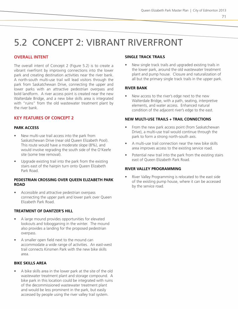
5.2 concept 2: vibrant riverfrontovErall INtENt
the overall intent of Concept 2 (figure 5.2) is to create a vibrant riverfront by improving connections into the lower park and creating destination activities near the river bank. a north-south multi-use trail will lead visitors through the park from saskatchewan drive, connecting the upper and lower parks with an attractive pedestrian overpass and bold landform. a river access point is created near the new walterdale bridge, and a new bike skills area is integrated with “ruins” from the old wastewater treatment plant by the river bank.
kEy FEatUrEs oF CoNCEPt 2
Park aCCEss
• new multi-use trail access into the park from saskatchewan drive (near old Queen Elizabeth Pool). this route would have a moderate slope (8%), and would involve regrading the south side of the o’keefe site (some tree removal).
• Upgrade existing trail into the park from the existing stairs east of the hairpin turn onto Queen Elizabeth Park road.
PEDEstrIaN CrossINg ovEr QUEEN ElIzabEtH Park roaD
• accessible and attractive pedestrian overpass connecting the upper park and lower park over Queen Elizabeth Park road.
trEatMENt oF DaNtzEr’s HIll
• a large mound provides opportunities for elevated lookouts and tobogganing in the winter. the mound also provides a landing for the proposed pedestrian overpass.
• a smaller open field next to the mound can accommodate a wide range of activities. an east-west trail connects kinsmen Park with the new bike skills area.
bIkE skIlls arEa
• a bike skills area in the lower park at the site of the old wastewater treatment plant and storage compound. a bike park in this location could be integrated with ruins of the decommissioned wastewater treatment plant and would be less prominent in the park, but easily accessed by people using the river valley trail system.
sINglE traCk traIls
• new single track trails and upgraded existing trails in the lower park, around the old wastewater treatment plant and pump house. Closure and naturalization of all but the primary single track trails in the upper park.
rIvEr baNk
• new access to the river’s edge next to the new walterdale bridge, with a path, seating, interpretive elements, and water access. Enhanced natural condition of the adjacent river’s edge to the east.
NEw MUltI-UsE traIls + traIl CoNNECtIoNs
• from the new park access point (from saskatchewan drive), a multi-use trail would continue through the park to form a strong north-south axis.
• a multi-use trail connection near the new bike skills area improves access to the existing service road.
• Potential new trail into the park from the existing stairs east of Queen Elizabeth Park road.
rIvEr vallEy PrograMMINg
• river valley Programming is relocated to the east side of the existing pump house, where it can be accessed by the service road.

72
5.3 featureS uniQue to each concept
FEatUrE CoNCEPt 1 CoNCEPt 2
Park aCCEss new multi-use trail along fort Hill road (below saskatchewan drive).
Potential new multi-use trail along Queen Elizabeth Park road.
accessible multi-use trail entry from saskatchewan drive to the old Queen Elizabeth Pool site which continues through the park to form a strong north-south multi-use axis.
Upgrade existing trail into the park from the existing stairs east of the hairpin turn onto Queen Elizabeth Park road.
PEDEstrIaN CrossINg ovEr QUEEN ElIzabEtH Park roaD
Multi-use trail overpass over Queen Elizabeth Park road.
trEatMENt oF DaNtzEr’s HIll
small slope (lookouts, tobogganing hill) connecting Queen Elizabeth Park road to a large open field
large mound (landmark, lookout point, tobogganing hill) and open field for flexible programming in the area currently occupied by dantzer’s Hill. an east-west trail across the field connects kinsmen Park to the new bike skills area.
rIvEr baNk the single-track trail is retained and a new lookout and interpretation opportunities are provided. no official river access area.
river access is provided next to the new walterdale bridge, allowing people to get down to the water’s edge. the single-track trail is upgraded to a more defined trail, with seating, and interpretation opportunities provided.
bIkE skIlls arEa situated in upper park, at site of old Queen Elizabeth Pool. access to strathcona neighbourhood and nearby parking.
situated in lower park at site of former wastewater treatment plant and storage compound. bike skills area incorporates “ruins” from old wastewater treatment plant. distance from parking.
sINglE-traCk traIls single-track trails upgraded and expanded in upper park. all but primary single-track trails in lower park are closed and naturalized.
single-track trails upgraded and expanded in lower park. all but primary single-track trails in upper park are closed and naturalized.
MUltI-UsE traIls aND traIl CoNNECtIoNs
new multi-use trail along the lower half of Queen Elizabeth Park road.
Potential new multi-use trail along upper half of Queen Elizabeth Park road.
new connection between picnic area and existing service road using combination of stairs and ramps.
accessible multi-use trail north-south from saskatchewan drive to the new walterdale bridge via overpass.
Multi-use trail connection near the new bike skills area for improved access to the river bank.
East-west trail across new field.
EtHNobotaNICal PlaNtINgs
dedicated area for ethnobotanical plantings in the lower park, with “ruins” from old wastewater treatment plant.
no dedicated area for ethnobotanical plantings; plantings incorporated throughout park.
rIvEr vallEy PrograMMINg
relocated to upper park, next to the old Queen Elizabeth Pool.
kept in lower park, but moved east of its current location.

73
Queen Elizabeth Park Master Plan | City of Edmonton 2013
wINtEr IN QUEEN ElIzabEtH Park
both conceptual designs for Queen Elizabeth Park allow for a variety of winter activities. (figures 5.3 and 5.4)
fill will be removed from dantzer’s Hill as part of the new walterdale bridge project, thereby creating the opportunity to re-grade this area into one of Edmonton’s best hills for tobogganing and other downhill uses (e.g. snow slide, snow scooters). in Concept 1 this hill is of a moderate size, while Concept 2 envisions it to be a larger, bolder mound feature that is linked to the pedestrian overpass. the hill would also provide good vantage points toward Edmonton’s winter skyline and snowy river valley.
new accessible paved paths are proposed to lead into the park from saskatchewan drive. these will be cleared of snow in the winter, thereby facilitating year-round access into the river valley. a network of cleared, paved paths will allow visitors to travel through the park and to adjacent parks and facilities (e.g. to kinsmen sports Centre) throughout the winter.
Unpaved paths and single-track trails will not be cleared in the winter, allowing these areas to be used for snowshoeing, winter hiking, and winter mountain biking when conditions allow.
Clearings within the park can be programmed for a wide variety of winter activities. the large open field north of the tobogganing hill has the potential to be a prominent location in the river valley for winter festivals and snow structures (e.g. snow forts, wind barriers, ice climbing walls, snow mounds). smaller clearings in the picnic areas could be equipped with portable gas fire pits, year-round barbeques, and/or temporary winter warming huts. More detailed design can ensure that sun, shadow, wind, and snow are considered to create comfortable outdoor microclimates.
for special events, food trucks could be brought in to sell hot drinks and food, and affordable winter equipment rentals could be provided (e.g. snowshoes, toboggans) to help visitors fully enjoy the park in winter.
interesting lighting can be incorporated into seating, paths, structures (e.g. pedestrian overpass) and other elements to enliven these spaces and extend their usability past daylight hours.
interpretation of the site could incorporate messaging that speaks to winter activities (e.g. winter wildlife) and cultural traditions for living in a cold climate.
5.4 winter activitieSwINtErCIty stratEgy INCorPoratIoN
the intent of the winterCity strategy is to transform Edmonton into a world-leading winter city. the Queen Elizabeth Park concepts incorporate a number of ideas encapsulated in the winterCity strategy, including:
• Creating a significant tobogganing hill in the current location of dantzer’s Hill;
• incorporating a fire pit into the lower park facility node to increase the comfort of winter users at the tobogganing hill;
• Enhancing the connectivity of cleared, paved paths to allow visitors to travel through the park and river valley;
• leaving unpaved paths and single-track trails uncleared in winter to be used for snowshoeing, winter hiking, and winter mountain biking when conditions allow;
• Providing a large accessible area for winter festivals, snow structures, and temporary winter warming huts.
Unique to Concept 2:
• Establishing a new accessible entry path from saskatchewan drive that will be cleared of snow in the winter, thereby facilitating year-round access.

74
fiGUrE 5.4 ConCEPt 2 witH wintEr aCtivitiEs ovErlaY
fiGUrE 5.3: ConCEPt 1 witH wintEr aCtivitiEs ovErlaY
flexible winter activity space potential for festivals,
snow structures, creative lighting, outdoor fire pits
flexible winter activity space potential for festivals,
snow structures, creative lighting, outdoor fire pits
Small toboggan hill
year-round barbeque pits in picnic areas
year-round barbeque pits in picnic areas
large tobogganing mound / winter slide
unpaved paths and single-track trails can be used for snowshoeing
accessible, cleared entry route into park
along fort hill rd
accessible, cleared entry route into park
potential accessible, cleared entry route
into park along Queen elizabeth
park road
unpaved paths and single-track trails can be used for snowshoeing
paved paths to be kept clear of snow
in winter
paved paths to be kept clear of snow
in winter
n100M
n100M
n100M
n100M

Queen Elizabeth Park Master Plan | City of Edmonton 2013
75
06 public conSultation SerieS #2

76
6.1 public workShop #2DatE: august 15, 2012, 6:30 to 8:30 pm
loCatIoN: old timers’ Cabin, 9430 scona road
NUMbEr oF PartICIPaNts: 20
MEEtINg PUrPosE:
the purpose of this workshop was to obtain public input on the alternative design concepts in order to help direct the development the preferred approach for the master plan. the vision, mission and guiding principles were presented for confirmation that they reflected input from the first round of public consultation.
MEEtINg ovErvIEw:
the meeting began with introductions, an overview of the process to date, and a review of opportunities for public participation. there was a presentation of the results from the first round of public consultations and a review of key opportunities and constraints of the park. the two preliminary design concepts were presented and key features and differences between the concepts were highlighted.
Participants were then divided into four groups (5 people each) to discuss the proposed vision, mission, guiding principles, and design concepts. Evaluation forms were used to direct the review of the concepts, but participants also had the opportunity to provide additional comments. Groups then presented their evaluations back to the rest of the workshop attendees.
CoMMENts oN vIsIoN, MIssIoN aND gUIDINg PrINCIPlEs:
the following are selected comments on the proposed park vision statement, mission statement, and guiding principles.
CoMMENts oN vIsIoN statEMENt:
“Queen Elizabeth Park is a well-loved destination in the heart of Edmonton where people come to connect with the natural world, have memorable gatherings with friends and family, discover the rich cultural heritage of the river valley, and experience a remarkable gateway into Downtown”
• the park should be a destination for all Edmontonians
• the park should stay natural, accommodate people, be special, and be safe
• the vision statement should recognize the range of
activity in the park (e.g. mountain biking, running, walking, orienteering, festivals, travel corridor)
CoMMENts oN MIssIoN statEMENt:
“To provide a variety of ways for Edmonton residents and visitors to experience, understand, and connect to the river valley environment”
• the mission statement is somewhat generic, but good
• the mission should convey that the park provides ways for people to be active
CoMMENts oN gUIDINg PrINCIPlEs:
• “The park is accessible for pedestrians and cyclists”
• statement should emphasize universal accessibility for all people, pedestrians and cyclists
• the statement should be inclusive of all human-powered users, including non-motorized boat users.
• “Amenities are provided to support user comfort (e.g. improved lighting and signage)”
• amenities should support user safety as well
• “The ecological character of the park is celebrated and enhanced”
• the ecological character of the park should be protected and restored as well
EvalUatIoN oF CoNCEPts:
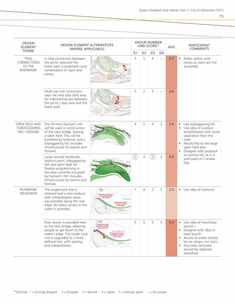
the following table (table 6-1) summarizes the group evaluations of the various design elements, organized by theme (e.g. connections, trails, field). Participants had been asked to score each element on a scale from “strongly disagree” (1) to “strongly agree” (5). average scores (out of 5) are indicated. Participants were also asked to choose three elements that they felt were the highest priorities for the park. these are indicated by circled numbers.
for detailed results of Public workshop #2, please see appendix a6.

77
Queen Elizabeth Park Master Plan | City of Edmonton 2013
Groups reporting back to rest of participants, Public workshop #2

78
DeSign eleMent theMe
DeSign eleMent alternativeS (where applicable)
group nuMber anD Score* avg participant
coMMentSg1 g2 g3 g4
nEw ConnECtions to / froM tHE
Park
fort Hill road access (separated trail or on-street marking, quite steep ~15% slope)
5 5 3 5 4.5 • would require small enhancements to make this an accessible park entry
trail along Queen Elizabeth Park road (north side of Queen Elizabeth Park road, significant impact on adjacent grades and forest, accessible slope ~8%)
1 1 3.5 1 1.6 • too expensive; money better saved for other things
new multi-use trail starting by 106 street (accessible slope ~8%, some tree removal and regrading)
5 5 5 1 4.0 • Preference is for multi-use trail connection at this location
Upgraded trail east of Queen Elizabeth Park road (requires stairs, some tree removal and regrading)
5 1 1 4 2.8 • Prefer unpaved path• Explore changing stairs
to path (ramp)
PEdEstrian ovErPass
the overpass connects the upper park and the field with a grade separated connection. the overpass also creates a gateway experience for people travelling along Queen Elizabeth Park road
5 5 5 -- 5.0 • location should be reviewed to minimize impact to trees
• overpass would be costly
• Proposed design doesn’t look “natural”
nortH-soUtH MUlti-UsE trail
new trail on north side of Queen Elizabeth Park road, connecting the east-west multi-use trail to new bridge.
3 4 5 -- 4.0
accessible, multi-use, north-south trail from saskatchewan drive to the new walterdale bridge via the new overpass.
5 5 5 -- 5.0
tablE 6-1. EvalUatIoN oF DEsIgN ElEMENts. CIrClED NUMbErs rEPrEsENt PrIorIty ElEMENts For EaCH groUP.
*scoring: 1 = strongly disagree 2 = disagree 3 = neutral 4 = agree 5 = strongly agree -- = no answer
79
Queen Elizabeth Park Master Plan | City of Edmonton 2013
DeSign eleMent theMe
DeSign eleMent alternativeS (where applicable)
group nuMber anD Score* avg participant
coMMentSg1 g2 g3 g4
trail ConnECtions
to tHE rivErbank
a new connection between the picnic area and the lower park is proposed using combination of stairs and ramps.
5 5 4 -- 4.7 • Prefer option with ramps as stairs are not accessible
Multi-use trail connection near the new bike skills area for improved access between the picnic / play area and the lower park.
5 2 5 -- 4.0
oPEn fiEld and toboGGaninG Hill / MoUnd
the fill from dantzer’s Hill will be used in construction of the new bridge, leaving a open field. this will be bordered by lookouts and a tobogganing hill. includes infrastructure for events and festivals.
4 5 4 2 3.8 • like tobogganing hill• like idea of outdoor
amphitheatre with some separation from the road
• would like to see large open field area
• disagree with proposal to remove hill, as it is well-used on Canada day
large mound (landmark, lookout point, tobogganing hill) and open field for flexible programming in the area currently occupied by dantzer’s Hill. includes infrastructure for events and festivals.
5 4 5 2 4.0
rivErbank trEatMEnt
the single-track trail is retained and a new lookout with interpretation areas are provided along the river edge. no direct access to the water is provided.
1 4 2 2 2.3 • like idea of lookouts
river access is provided next to the new bridge, allowing people to get down to the water’s edge. the single track trail is upgraded to a more defined trail, with seating, and interpretation.
5 5 5 5 5.0 • like idea of hand boat launch /
• disagree with idea of boat launch
• access to water should be via ramps, not stairs
• any trees removed should be replaced elsewhere
*scoring: 1 = strongly disagree 2 = disagree 3 = neutral 4 = agree 5 = strongly agree -- = no answer

80
DeSign eleMent theMe
DeSign eleMent alternativeS (where applicable)
group nuMber anD Score* avg participant
coMMentSg1 g2 g3 g4
bikE skills arEa
situated in the upper park, at site of old Queen Elizabeth Pool. this will consist of dirt jumps and other bike skill features. this is accessible to the strathcona neighbourhood and has parking nearby.
5 5 1 1 3.0 • location of skills area doesn’t matter as long as there is one
• skills area should be connected to single track trails
• should be an area for kids
situated in the lower park at the site of the former wastewater treatment plant and storage compound. bike skills area incorporates “ruins” from old wastewater treatment plant. not directly adjacent to parking.
5 1 5 3 3.5
sinGlE-traCk trails
single track trails upgraded and expanded in upper park. all but primary single track trails in lower park are closed and naturalized.
5 4 1 -- 3.3 • like naturalized trail by river
• desire to see single-track trails in both upper and lower parks
single-track trails upgraded and expanded in lower park. all but primary single track trails in upper park are closed and naturalized.
5 4 5 -- 4.7
EtHno-botaniCal PlantinGs
dedicated area for ethnobotanical plantings and a natural park experience in the lower park, with “ruins” from old wastewater treatment plant.
-- 5 2 -- 3.5 • like idea• disagree with proposed
location of plantings by old wastewater treatment plant
• location for plantings doesn’t matter
no dedicated area for ethnobotanical plantings (incorporated throughout park). traditional use of plants identified through interpretation.
5 3 5 -- 4.3
iMProvEd at-GradE
PEdEstrian CrossinG
the pedestrian crossing midway down Queen Elizabeth Park road will be moved north and better defined to provide a safer crossing of the roadway.
5 5 4 5 4.8 • should have lighting• safety should be
improved
*scoring: 1 = strongly disagree 2 = disagree 3 = neutral 4 = agree 5 = strongly agree -- = no answer
*

81
Queen Elizabeth Park Master Plan | City of Edmonton 2013
DeSign eleMent theMe
DeSign eleMent alternativeS (where applicable)
group nuMber anD Score* avg participant
coMMentSg1 g2 g3 g4
ExPandEd MUlti-UsE trail
nEtwork
throughout the park the multi-use trail network will be upgraded to provide a variety of experiences and provide better connections to the neighbourhood and to all parts of the park.
5 4 5 -- 4.7 • Have a mix of trail types; not all trails should be paved
• Concern with environmental degradation; the amount of trees removed should be replanted
iMProvEd sinGlE
traCk trails tHroUGH
forEst
the quality, location, design and construction standards of single track trails will be improved to minimize impact on natural areas.
5 5 1 -- 3.7
nEw lookoUts and iMProvEMEnt
to ExistinG lookoUts
new lookouts and improvements to existing lookouts to provide views of downtown and the river valley.
5 3 5 -- 4.3 • lookouts nice to have, but not top priority
EnHanCEd PlaY arEa
the playground will be designed and upgraded to provide a wider range of activities and play experiences for children. this will include nature-based play to help connect children to the natural environment.
5 5 4 3 4.3 • Could incorporate water feature
• Prefer play area to not take over open spaces
• include educational elements
• Concern with expanded parking area that may be required
• Concerned with road traffic and playground users
• Perhaps better to have smaller playground nodes instead of one large playground
EnHanCEd PiCniC arEa
Upgrades to existing picnic facilities and more facilities throughout the park.
5 5 4 -- 4.7
*scoring: 1 = strongly disagree 2 = disagree 3 = neutral 4 = agree 5 = strongly agree -- = no answer
82
aDDItIoNal CoMMENts:
additional comments and suggestions for the park design included the following:
• incorporation of an outdoor chess board, cross-country ski trails, a water feature, and identification (interpretation) of archaeological sites.
• Greater clarity on how the park’s ecological character will be protected and enhanced.
• improvements to the multi-use trail along saskatchewan drive.
• Considerations for park management, including cleaning up garbage along the river path, incorporating reservable picnic sites, and developing a plan for snow grooming / clearing to allow pedestrian use and possible cross-country skiing.

83
Queen Elizabeth Park Master Plan | City of Edmonton 2013
6.2 public online Survey #2DatE: survey period from august 16 to 31, 2012
NUMbEr oF rEsPoNDENts: 309
sUrvEy PUrPosE:
the purpose of the online survey was to complement Public workshop #2, whereby the proposed vision, mission, guiding principles and alternative design concepts were presented to participants for feedback and evaluation.
the survey represents a “convenience” sampling of river valley park users, and is not scientific; thus, the results do not necessarily reflect general public opinion.
there were 309 people who participated in the survey. respondents were not obliged to complete the entire survey, so the number of responses for each question was variable (268 - 308). the number of question responses is reported with the results.
for complete responses to Public online survey #2, please see appendix a7.
oPINIoNs rEgarDINg tHE ProPosED vIsIoN, MIssIoN aND gUIDINg PrINCIPlEs:
vIsIoN statEMENt:
“Queen Elizabeth Park is a well-loved destination in the heart of Edmonton where people come to connect with the natural world, have memorable gatherings with friends and family, discover the rich cultural heritage of the river valley, and experience a remarkable gateway into Downtown”
the majority of respondents (76%) agreed or strongly agreed with the vision statement as presented (figure 6.1).
one percent of respondents suggested recreation be added to the vision statement in some way. two percent of respondents questioned the idea of the park being a “gateway” into downtown. three people (<1% of respondents) did not think the park should be positioned as a “destination” into downtown.
fiGUrE 6.1. degree of support for the vision statement.
strongly agree
agreeneutraldisagreestrongly disagree
76% sUPPort
nU
MbE
r o
f rE
sPo
nd
Ents
84
selected comments regarding the vision statement:
“...Vision needs to recognize the many active uses of the park for running, orienteering, paddling, cycling, etc.”
“I like that connecting to the natural world is the first priority”
“... I don’t understand the ‘gateway into Downtown’ aspect. I go to the river valley to escape the city. I don’t want to be reminded of downtown while I’m there.”
“...I want the park to be a destination, and integrated into the heart of the city. That means being a directly linked part of Strathcona and also an extension of the Downtown river valley area.”
“Doesn’t directly mention connect to the river, access the river.”
“Live near the park and see many family picnics, church gatherings, scouts, etc.”
MIssIoN statEMENt:
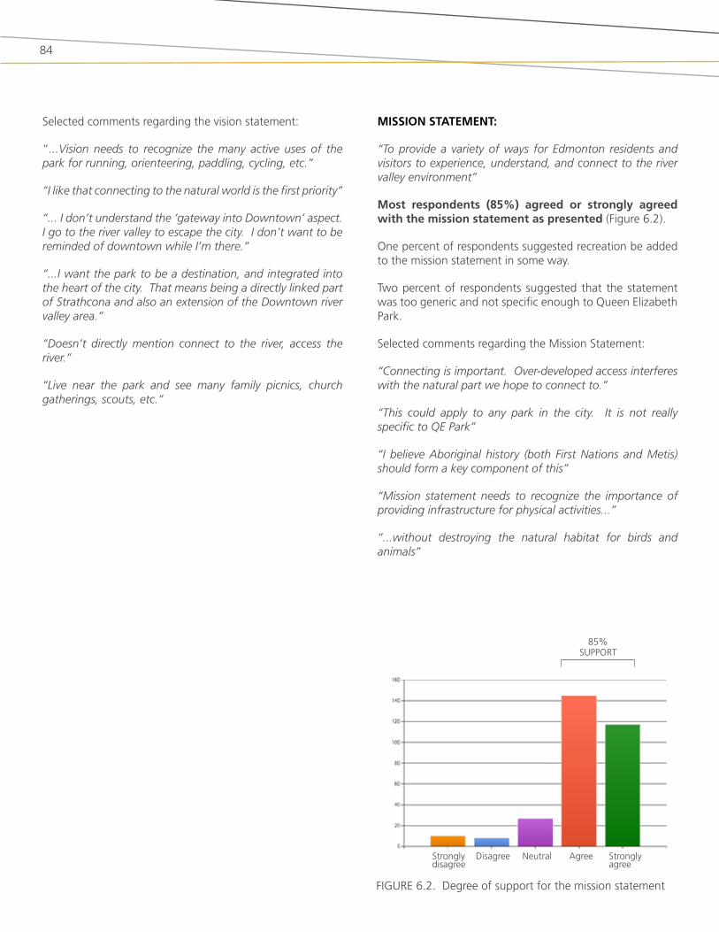
“To provide a variety of ways for Edmonton residents and visitors to experience, understand, and connect to the river valley environment”
Most respondents (85%) agreed or strongly agreed with the mission statement as presented (figure 6.2).
one percent of respondents suggested recreation be added to the mission statement in some way.
two percent of respondents suggested that the statement was too generic and not specific enough to Queen Elizabeth Park.
selected comments regarding the Mission statement:
“Connecting is important. Over-developed access interferes with the natural part we hope to connect to.”
“This could apply to any park in the city. It is not really specific to QE Park”
“I believe Aboriginal history (both First Nations and Metis) should form a key component of this”
“Mission statement needs to recognize the importance of providing infrastructure for physical activities...”
“...without destroying the natural habitat for birds and animals”
fiGUrE 6.2. degree of support for the mission statement
strongly agree
agreeneutraldisagreestrongly disagree
85% sUPPort

85
Queen Elizabeth Park Master Plan | City of Edmonton 2013
gUIDINg PrINCIPlEs:
there was generally a good level of support for all of the guiding principles (figure 6.3).
the principles that received the highest level of agreement were:
• the park is accessible for pedestrians and cyclists (94% agree + strongly agree);
• the pathway network is well-connected (90%);
• the ecological character of the park is celebrated and enhanced (75%); and
• opportunities are provided to experience the river’s edge (74%).
three percent of respondents stressed the value of having river access, particularly for hand boat launching (5 comments). one person stressed that river access should be done sensitively, and another thought the river bank was too sensitive for any development to occur.
one percent of respondents emphasized that the park should be universally-accessible to all park users, including people with walkers, strollers, and wheelchairs.
likewise, 1% of respondents did not understand the concept of having a “hierarchy” of spaces, and did not want this to translate into some users having priority over other users.
several people (2% of respondents) did not agree with the concept of the park acting as a “gateway” into downtown. these respondents appeared concerned that a “gateway” experience would mean constructed infrastructure of some kind along the road, or that a gateway role would detract from the park providing an escape from the city.
selected comments regarding guiding principles:
“Accessible to all citizens (disabled, young, old, mothers with strollers, etc.”
“Not sure what you mean by ...’hierarchy’... a variety of uses is good but that implies some are more important than others...”
“I want to emphasize the importance I perceive in having the edge of river be accessible. Although Edmontonians have plentiful ... opportunities to engage with the river valley, opportunities to engage the river itself are relatively slim”
“I hope there will be a strong Aboriginal presence in the interpretation and sense of place”
“I really want to see Edmonton’s profile enhanced, having a well-designed park that provides a ‘gateway’ experience”
accessible
well-
Connected
Hierarchy
Com
fort
important
Places
Ecological C
haracter
Experience river’s Edge
Gatew
ay
strongly agree
lEGEnd: agree neutral disagree strongly disagree
fiGUrE 6.3. degree of support for the guiding principles

86
strongly agree
agreeneutraldisagreestrongly disagree
strongly agree
agreeneutraldisagreestrongly disagree
fiGUrE 6.4. degree of support for a pedestrian overpass
fiGUrE 6.5 degree of support for river access
FEEDbaCk oN ProPosED DEsIgN ElEMENts:
PEDEstrIaN ovErPass:
Eighty-one percent of respondents agreed or strongly agreed with the idea of a pedestrian overpass over Queen Elizabeth Park road (figure 6.4).
aCCEss to rIvEr’s EDgE:
the majority of respondents (75%) supported or strongly supported the idea of having physical access to the river’s edge (figure 6.5).
IMProvED aCCEss INto tHE Park FroM saskatCHEwaN DrIvE:
survey participants were asked to rank four options for new pedestrian access into the park from the south (strathcona neighbourhood / saskatchewan drive), and results are shown in figure 6.6. illustrations and additional descriptions of the different options are shown in table 1-1.
the overall most preferred option was for a new multi-use trail entering the park from near the north end of 106 street (selected by 61% of respondents as either #1 or #2 choice). this was followed by improvements to fort Hill road (selected by 54% as #1 or #2), and building a new trail along Queen Elizabeth Park road (selected by 51% as #1 or #2). improving the entrance east of Queen Elizabeth Park road (selected by 39% as #1 or #2) was the lowest ranked entrance option.
fiGUrE 6.6. degree of support for the four different access options
nEw
trail
alo
nG
fort
Hill ro
ad
nEw
MU
lti-U
sE trail bY
106 st
nEw
trail
alo
nG
QE
Park
roa
d
iMPro
vEd
trail
East o
f QE
Park
roa
d
1 Most preferred
4 least preferred
2
81% sUPPort
ovErall raNk:
75% sUPPort
#2 #1 #3 #4
3lEGEnd:

87
Queen Elizabeth Park Master Plan | City of Edmonton 2013
bIkE skIlls arEa:
there was no clear preference for having the bike skills area in the upper or lower park (figure 6.7). twelve percent of respondents did not want to see a bike skills area in Queen Elizabeth Park. thus, other factors will need to be considered to inform the location of the bike skills area.
sINglE traCk traIls:
figure 6.8 illustrates the level of support for different single track trail options in Queen Elizabeth Park. the majority of respondents (45%) are in favour more single track trails in the park, but 32% are satisfied with the current number of trails. twenty-three percent of respondents want some degree of trail closure (fewer single track trails overall or fewer single track trails in some areas of the park).
Picnic area “ruins”Play arealookoutsMulti-use trails
fiGUrE 6.9. degree of support for other proposed elements
strongly agree
lEGEnd: agree neutral disagree strongly disagree
MUltI-UsE traIls:
the majority of respondents (61%) agreed or strongly agreed with the idea of an expanded multi-use trail network throughout the park (figure 6.9). a fifth of the respondents (22%) were opposed to having an expanded multi-use trail network.
lookoUt PoINts:
seventy percent of respondents agreed or strongly agreed with having new lookout points and improved lookout points to provide views of downtown and the river valley (figure 6.9).
ENHaNCED Play arEa:
a majority (60%) of respondents agreed with the idea of an enhanced play area (figure 6.9).
ENHaNCED PICNIC arEas:
Most respondents (60%) supported having enhanced picnic areas (figure 6.9).
“rUINs” FroM wastEwatEr trEatMENt PlaNt:
there were mixed opinions on keeping “ruins” from the old wastewater treatment plan, with 45% of respondents in favour of the idea, and 30% of respondents opposed (figure 6.9).
neither (no bike
park)
no preference
lower park
Upper park
fiGUrE 6.7. degree of support for different bike skills area location options
no changeMore in some areas
/ less in other areas
fewer single track
trails
More single track
trails
fiGUrE 6.8. degree of support for different single track trail options
88% sUPPort

88
PrIorIty ElEMENts:
survey respondents were asked to select three priority design elements from a list of 15 potential new or improved features (figure 6.10). the top four elements were:
• New / upgraded single-track trails (selected by 38% of respondents)
• bike skills area (selected by 37% of respondents)
• Pedestrian overpass (selected by 37% of respondents)
• opportunities for all-season activities (selected by 35% of respondents)
the next most popular element was enhanced ecological health of the forest and river bank (30% of respondents).
respondents were also given the opportunity to identify other well-liked concept features that were not on the list. the most popular response was for a hand boat launch / river access (3% of respondents).
some respondents took the question as an opportunity to suggest new features for the park. the most popular suggestion for new features included a disc (frisbee) golf course (2% of respondents).
Pedestrian overpass over QE Park road
bike skills area
opportunities for all-season activities
Enhanced ecological health of forest / riverbank
improved lookout points
Enhanced play area
Enhanced picnic areas
open field for a range of uses
Closure of some single-track trails
improved physical / visual access to the river near walterdale bridge
improved access into the park from saskatchewan drive
Ethnobotanical plantings (e.g. native plants traditionally used by first nations / early settlers)
Hill for viewpoints / tobogganing on the north side of QE Park road
“ruins” from old wastewater treatment plant incorporated into park design
new / improved single-track trails
fiGUrE 6.10. Most well-liked features (potential new or improved) for Queen Elizabeth Park

89
Queen Elizabeth Park Master Plan | City of Edmonton 2013
gENEral CoMMENts:
additional comments were given by 92 respondents. the following were some of the more widely-held ideas reported in these comments (figure 6.11):
• Many people (18) emphasized their support for a bike skills park. a few people stressed that it should be highly visible in order to ensure it is safe for kids and families.
• several people (16) expressed support for new or enhanced single track trails; six people stressed the importance of not turning these into gravel or paved paths. Many of these respondents were mountain bikers, but a few were hikers or trail runners.
• Many respondents (16) stressed the importance of keeping the park in a mostly natural / undeveloped state. several comments were received expressing concern with the environmental impacts of new trail development.
• twelve respondents emphasized the importance of ensuring the park has improved access for a wide range
of users and mobility levels (universal accessibility).
• Many (11) respondents emphasized their support for the pedestrian overpass, and several others (5) stressed the importance of making the at-grade pedestrian crossing safer. a couple of people expressed concern that a pedestrian overpass would block views of downtown or that it could take up too much space in the park.
• river access and/or a potential hand boat launch proved to be popular ideas, mentioned by 7 respondents. a few people raised safety concerns with allowing better access to the river (e.g. people falling in the river and getting swept downstream).
• several people (7) mentioned the importance of telling the history of the site, and several liked the use of the wastewater treatment site “ruins” to tell part of this story.
fiGUrE 6.11. “word cloud” generated from general comments. the size of the word is proportional to the number of times it was mentioned in the survey comments.

90
6.3 aboriginal coMMunity Meeting #2DatE: august 28, 2012, 5:00-7:00pm
loCatIoN: wicihitowin offices, Edmonton
NUMbEr oF PartICIPaNts: 11
attENDEEs: aretha Greatrix – wichitowin secretariat, Community liasion
beverly Crier – samson Cree nation Museum and interpretive Centre
Helen Calahasen – Executive director, dreamspeakers film festival society
Ed lavalee – wicihitowin Elders Circle
Calvin bruneau – Chief of Papaschase first nation
Harvey buffalo – samson Cree nation
Marilyn buffalo – samson Cree nation
arthur abel – artist
aboriginal relations office, City of Edmonton: leona Carter jaimy Miller Gord stewart
City of Edmonton facilitators: Michelle Hartlaub and rhonda norman, river valley Park and facility development
MEEtINg PUrPosE:
the purpose of this workshop was to obtain input on the alternative design concepts, and to confirm that the vision, mission and guiding principles reflected input from the first round of consultation. this meeting marked the second consultation with the aboriginal community.
MEEtINg ovErvIEw:
the meeting began with introductions, an overview of the process to date, and a review of opportunities for public participation. there was a presentation of the results from the first round of public consultations, and a review of key opportunities and constraints of the park. the two preliminary design concepts were presented and key features and differences between the concepts were highlighted.
the facilitators then walked through the evaluation form with the group, and answers were provided by consensus. one participant elected to fill in their own evaluation form. Explanations for the choices made were documented on the evaluation form. time constraints did not allow for all questions to be addressed. Participants were directed to individually complete the online survey.
EvalUatIoN oF DEsIgN CoNCEPts:
in general, there was a high degree of support for many of the design elements shown in Concept 2 (table 6-2). the following elements all received a score of 5 in the group evaluation exercise, indicating a strong level of support:
• Park access from saskatchewan Drive near 106 street along a new multi-use trail. Participants preferred this access route over the others for the following reasons: safer, accessible (grade can allow strollers and wheelchairs), can enjoy the scenery, meanders, touches more areas of the park, easier public access.
• Pedestrian overpass. Participants indicated their preference for having an overpass as it would provide views, interpretive opportunities, and safe access across Queen Elizabeth Park road.
• accessible, multi-use, north-south trail extending from saskatchewan drive to the new walterdale bridge, via the pedestrian overpass.
• Multi-use trail connection that connects the new bike skills Park to the main picnic area. Participants liked this option for its ability to provide an accessible connection to the lower park.
• large mound and open field by the walterdale bridge.
• Provision for river access near the new walterdale bridge. Participants noted their preference for this to have a natural design, and for it to be kept small.
otHEr CoMMENts:
the following were recommendations or suggestions for incorporating aboriginal stories and cultural values into Queen Elizabeth Park:
• interpretive panel on bridge telling story about what was found during archeological dig (other locations possibly);
• something underground for interpretation of site

91
Queen Elizabeth Park Master Plan | City of Edmonton 2013
(underground museum, build into ground);
• site map to tell story;
• artisans selling goods;
• statue on the south side of river - statues/art depicting aboriginal culture;
• Privacy for ceremonies;
• strathcona science Centre – historically famous for obsidian
• Hay lakes trail – Queen Elizabeth Park road;
• Connect north and south side of river – possible interpreters on site;
• want to see a designated space for aboriginals (similar to victoria island in ottawa)
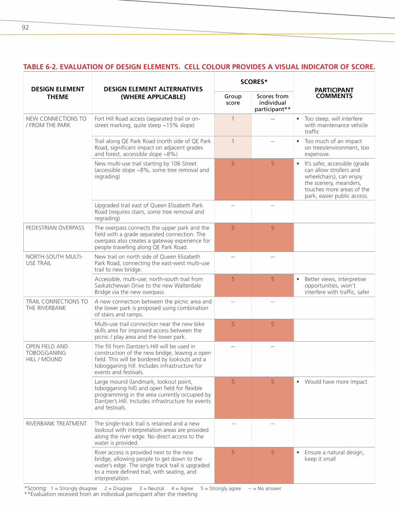
92
DEsIgN ElEMENt tHEME
DEsIgN ElEMENt altErNatIvEs (wHErE aPPlICablE)
sCorEs*PartICIPaNt CoMMENtsgroup
scoreScores from individual
participant**
nEw ConnECtions to / froM tHE Park
fort Hill road access (separated trail or on-street marking, quite steep ~15% slope)
1 -- • too steep, will interfere with maintenance vehicle traffic
trail along QE Park road (north side of QE Park road, significant impact on adjacent grades and forest, accessible slope ~8%)
1 -- • too much of an impact on trees/environment, too expensive.
new multi-use trail starting by 106 street (accessible slope ~8%, some tree removal and regrading)
5 5 • it’s safer, accessible (grade can allow strollers and wheelchairs), can enjoy the scenery, meanders, touches more areas of the park, easier public access.
Upgraded trail east of Queen Elizabeth Park road (requires stairs, some tree removal and regrading)
-- --
PEdEstrian ovErPass the overpass connects the upper park and the field with a grade separated connection. the overpass also creates a gateway experience for people travelling along QE Park road.
5 5
nortH-soUtH MUlti-UsE trail
new trail on north side of Queen Elizabeth Park road, connecting the east-west multi-use trail to new bridge.
-- --
accessible, multi-use, north-south trail from saskatchewan drive to the new walterdale bridge via the new overpass.
5 5 • better views, interpretive opportunities, won’t interfere with traffic, safer
trail ConnECtions to tHE rivErbank
a new connection between the picnic area and the lower park is proposed using combination of stairs and ramps.
-- --
Multi-use trail connection near the new bike skills area for improved access between the picnic / play area and the lower park.
5 5
oPEn fiEld and toboGGaninG Hill / MoUnd
the fill from dantzer’s Hill will be used in construction of the new bridge, leaving a open field. this will be bordered by lookouts and a tobogganing hill. includes infrastructure for events and festivals.
-- --
large mound (landmark, lookout point, tobogganing hill) and open field for flexible programming in the area currently occupied by dantzer’s Hill. includes infrastructure for events and festivals.
5 5 • would have more impact
rivErbank trEatMEnt the single-track trail is retained and a new lookout with interpretation areas are provided along the river edge. no direct access to the water is provided.
-- --
river access is provided next to the new bridge, allowing people to get down to the water’s edge. the single track trail is upgraded to a more defined trail, with seating, and interpretation.
5 5 • Ensure a natural design, keep it small
tablE 6-2. EvalUatIoN oF DEsIgN ElEMENts. CEll ColoUr ProvIDEs a vIsUal INDICator oF sCorE.
*scoring: 1 = strongly disagree 2 = disagree 3 = neutral 4 = agree 5 = strongly agree -- = no answer**Evaluation received from an individual participant after the meeting

93
Queen Elizabeth Park Master Plan | City of Edmonton 2013
DEsIgN ElEMENt tHEME
DEsIgN ElEMENt altErNatIvEs (wHErE aPPlICablE)
sCorEs*PartICIPaNt CoMMENtsgroup
scoreScores from individual
participant**
bikE skills arEa situated in the upper park, at site of old Queen Elizabeth Pool. this will consist of dirt jumps and other bike skill features. this is accessible to the strathcona neighbourhood and has parking nearby.
-- --
situated in the lower park at the site of the former wastewater treatment plant and storage compound. bike skills area incorporates “ruins” from old wastewater treatment plant. not directly adjacent to parking.
-- 5
sinGlE-traCk trails single track trails upgraded and expanded in upper park. all but primary single track trails in lower park are closed and naturalized.
-- --
single-track trails upgraded and expanded in lower park. all but primary single track trails in upper park are closed and naturalized.
-- 5
EtHnobotaniCal PlantinGs
dedicated area for ethnobotanical plantings and a natural park experience in the lower park, with “ruins” from old wastewater treatment plant.
-- --
no dedicated area for ethnobotanical plantings (incorporated throughout park). traditional use of plants identified through interpretation.
-- 5
iMProvEd at-GradE PEdEstrian CrossinG
the pedestrian crossing midway down Queen Elizabeth Park road will be moved north and better defined to provide a safer crossing of the roadway.
-- --
ExPandEd MUlti-UsE trail nEtwork
throughout the park the multi-use trail network will be upgraded to provide a variety of experiences and provide better connections to the neighbourhood and to all parts of the park.
-- 5
iMProvEd sinGlE traCk trails tHroUGH forEst
the quality, location, design and construction standards of single track trails will be improved to minimize impact on natural areas.
-- 5
nEw lookoUts and iMProvEMEnt to ExistinG lookoUts
new lookouts and improvements to existing lookouts to provide views of downtown and the river valley.
-- 5
EnHanCEd PlaY arEa the playground will be designed and upgraded to provide a wider range of activities and play experiences for children. this will include nature-based play to help connect children to the natural environment.
-- 5
EnHanCEd PiCniC arEa Upgrades to existing picnic facilities and more facilities throughout the park.
-- 5

94
sUMMary oF FINDINgs:
PartICUlar FEatUrEs tHat PartICIPaNts lIkED:
• increased pedestrian safety that would be attained by adding an overpass over Queen Elizabeth Park road
• river access (Concept 2)
• winter concepts and warming huts
sUggEstIoNs For MastEr PlaN:
• do not put in a boat launch as access would be difficult and there is a launch at nearby Emily Murphy Park.
• Explore adding a skating trail to park design
• Consider an additional washroom building in the lower park (e.g. at the ‘node’) to increase washroom access for a wider range of park users.
• Ensure removal of wastewater treatment plant.
• Provide universally-accessible amenities (e.g. washrooms, picnic tables, benches)
CoNsIDEratIoNs For DEtaIlED DEsIgN aND Park MaNagEMENt:
• Provide rentals for cross-country skiing, snowshoeing or toboggans at the park
• incorporate lighting
• Consider having reservable picnic sites
• Consider whether all hard trails should be cleared of snow/ice
• Consider providing event area with (winterized) power supply, water supply, and access for vehicles to load / unload equipment
• increase washroom capacity and make washrooms available year-round
• Provide signage to direct people to the park, direct people within the park, and provide information on trails.
• Ensure the toboggan hill is officially sanctioned by the City (official toboggan area) and built with a safe landing at the bottom
• issue with pedestrians crossing walterdale Hill rd from fort Hill rd to kinsmen Park; crossing unmarked and unsafe
DatE:
aUGUst 16, 2012, 10:30 - 11:30am
loCatIoN:
Cn tower, 12th floor, Edmonton
NUMbEr oF PartICIPaNts: 21
MEEtINg PUrPosE:
the internal open house provided City of Edmonton staff with an opportunity to review the preliminary design concepts for Queen Elizabeth Park. the consultant team presented the concepts to attendees and attendees were then able to review the concept boards and ask questions of the project team.
attENDEEs:
Members of City of Edmonton staff, including:
susan Holdsworth, Community strategies
alan otterbein, district Park and facility development
barry M sawchuk, Contract operations
jaimy Miller, aboriginal relations office
Christine lachance, district Park and facility development
tyler Golly, sustainable transportation
darrell reid, river valley operations
barry lozinsky, river valley operations
kerry kaboni, Playground / Utilities
Marian bruin, Community strategies
tatenda kwedza, Parks land Planning
bill bunker, Project Manager, river valley alliance
Gary Chung, district Park and facility development
jenny wheeler, Principal of forestry
sandra opdenkamp, river valley Park and facility development
diana o’donoghue, Communities of interest
Heather Crowe, Communities of interest
Erin Gillespie, district Park and facility development
Corinne bishop, district Park and facility development
Mike kuntz, district Park and facility development
roger jevne, river valley Park and facility development
City of Edmonton Project team: Michelle Hartlaub and rhonda norman
Project consultant team: jeff Cutler and Mike teed, space2place design inc.
6.4 internal open houSe
95
Queen Elizabeth Park Master Plan | City of Edmonton 2013
6.5 SuMMary of conSultation SerieS #2in the second round of public consultations, two design options were presented and evaluated by the public and City staff. Consultation events included public workshop #2, an internal (City of Edmonton staff) open house, public online survey #2, and the aboriginal Community meeting #2.
FEEDbaCk oN vIsIoN, MIssIoN aND gUIDINg PrINCIPlEs
the majority of participants supported the vision statement, Mission statement, and Guiding Principles as presented. some comments on the vision statement suggested adding language that expressed the importance of recreation in the park and removing the reference to the park being a “gateway.” some participants felt that the Mission statement was too generic and some people wanted to see language added regarding activity in the park. all of the guiding Principles were supported but some participants wanted to see more emphasis placed on universal accessibility and on river access.
PrEFErrED DEsIgN ElEMENts to bE INClUDED IN tHE MastEr PlaN
the following are the priority design elements that received the highest amount of support during the second round of consultation events:
• IMProvINg aCCEss INto tHE Park FroM tHE soUtH was explored through several design options. the most preferred option (selected by 61% of online survey respondents as either #1 or #2 choice) was for a new park entrance and multi-use trail from saskatchewan drive near the north end of 106 street. there was some support for improving access into the park along fort Hill road.
• IMProvINg NortH-soUtH MUltI-UsE traIl CoNNECtIoNs between saskatchewan drive and the new walterdale bridge was strongly supported. there was good support for improved and expanded multi-use trail connections throughout the park.
• bUIlDINg a NEw PEDEstrIaN ovErPass over Queen Elizabeth Park road received a high level of support. the overpass was identified by online survey respondents as a top priority.
• bUIlDINg a largE MoUND (for tobogganing, viewpoint, landmark) in place of dantzer’s Hill received a high level of support and was selected by two workshop groups as a top priority for implementation.
• ForMalIzINg aCCEss to tHE rIvEr received a good level of support (75% support in online survey). this design element was selected as a top priority for implementation in the online survey.
• bUIlDINg a NEw MoUNtaIN bIkE skIlls arEa received very strong support (88% support in online survey). there was no clear preference for the bike park location.
• IMProvINg aND/or ExPaNDINg sINglE traCk traIls throughout the park or in selected areas of the park was supported by 59% of online survey respondents; however there were many people who were satisfied with the number of single track trails in the park today (32%), or who wanted to see fewer of these trails (9%).
• INCorPoratINg EtHNobotaNICal PlaNtINgs throughout the park received a good amount of support (average score 4.3/5 in public workshop). Participants liked the idea of using interpretation to tell the stories about traditional uses of native plants.
• ProtECtINg aND ENHaNCINg tHE ECologICal HEaltH oF tHE ForEst aND rIvErbaNk was identified as a top priority in the online survey (top priority for 30% of respondents), and there were many comments received throughout the public consultation in support of preserving the park’s natural qualities.
• INtErPrEtatIoN oF NatUral aND CUltUral HIstory oF tHE Park received a good level of support based on online survey comments.
• IMProvINg tHE at-graDE PEDEstrIaN CrossINg to improve pedestrian safety received a high level of support (average score of 4.8/5 at public workshop).
• ENHaNCINg Play aND PICNIC arEas received a good level of support (60% support for each in online survey).
• INCorPoratINg “rUINs” FroM tHE olD wastEwatEr trEatMENt PlaNt received some support in the online survey (45% support, 25% neutral).
• IMProvINg aND aDDINg NEw lookoUts received some support in the online survey (45% support, 21% neutral).

Queen Elizabeth Park Master Plan | City of Edmonton 2012
96