quadrotor for indoor surveillance and reconnaissance conference... · quadrotor for indoor...
TRANSCRIPT

Quadrotor for Indoor
Surveillance and
Reconnaissance
Steven Viska, Scott Kline, Callie Chen, Giuseppe Tonini, Harsh Shah
Department of Aerospace Engineering
Cal Poly Pomona
AIAA Research Conference

Overview
• Unmanned Aerial Vehicles (UAVs)
• Motivations
• Research Objectives
• Simultaneous Localization and Mapping
• Hardware
• Software
• Obstacle Avoidance
• Autonomous Flight
• Conclusion
• Future Work
2

Unmanned Aerial Vehicles • Unmanned Aerial Vehicle
– Remotely piloted by
human or autonomous
(using autopilot)
• Replace manned operations
to reduce human risk, cost,
and expand capabilities
• Used for: surveillance, target
strike, search and rescue
missions, precision
agriculture, etc.
3

Motivations
• Autonomous navigation in GPS denied indoor
environments
• Aerial reconnaissance for assessment of
indoor environments
• Investigate unknown environments
• Evaluate hazardous or inaccessible
environments
• Minimize human risk
• Promote usability of indoor UAVs
4

Research Objectives
• Implementation of Simultaneous Localization and Mapping (SLAM) for navigation in indoor environments
• Develop a quadrotor capable of supporting the system.
• Minimal size and weight
• Payload capacity and integration
• 3D imaging
• Real-time mapping using a 3D Imaging Camera
• Design a portable power plant
• Wireless capabilities
• Data acquisition from 3D Imaging Camera
5

SLAM
• “Simultaneous localization and mapping”
• Use of 3D Imaging Camera sensors for 3D mapping
- Infrared (IR) projector
- RGB camera
- IR monochrome camera
• Use of FARO Scenect™ software for 3D image
integration
6

SLAM (cont.)
• Technique used by autonomous vehicles to
build/update map of an environment, while keeping
track of current location
• Use of many different sensors: 1D to 3D
• 3D Imaging Camera sensors utilize 3D image
reconstruction based on depth perception
information
• 3D vision describes not only shape, texture, and
color but depth and distance
7

3D Imaging Cameras • Microsoft Kinect and Asus Xtion Live Pro sensors
used for 3D image reconstruction:
• Infrared (IR) projector
• RGB camera
• IR monochrome camera
8

Camera Comparison
9
Asus Xtion Live Pro Microsoft Kinect
Price ≈$150 ≈$150
Power Consumption <2.5 W 12 W
Distance of use 0.8 m < x < 3.5 m 0.8 m < x < 4 m
Field of View 58° H; 45° V; 70° D 57.5° H; 43.5° V
Depth Image Size VGA (640 x 480) 30 fps; QVGA (320 x 240) 60 fps
VGA (640 x 480) 30 fps
Resolution SXVGA (1280*1024) SXVGA (1280*960)
Software Open NI SDK bundled Kinect for Windows SDK
Dimensions 18 x 3.5 x 5 cm 28 x 8 x 8 cm

3D Mapping Process • Signals are emitted from the IR projector
• Reflected infrared signals are retrieved on the IR
monochrome camera
• 3D depth map is generated
• Chromatic and 3D depth images can be obtained
simultaneously with texture from the RGB camera
• Camera provides automatic calibration based on
physical environment
• Accommodates for the presence of obstacles
10

Architecture for 3D Mapping
11

Raspberry Pi
• Possible solution for wireless
data transmission
• Description:
• Single board computer
• Considered due to its small size,
light weight and Wi-Fi
capability
• Method: 802.11abgnAC
interface can be used to transmit
images compressed or device
native/raw
12

Camera Hardware Architecture
13
3D
Imaging
Camera
Raspberry Pi
Model B
Wi-Fi
Dongle
Power Supply
Receiver
Ground
Station
USB Connection
USB
Connection
Micro USB
Connection
Wireless
Signal
Black – Signal
Red – Power

Quadrotor Vehicle
14

Autopilot and Sensors
Remote
Receiver APM 2.6
Motors
Sensors
(Gyro/Accel/Baro) Rangefinders
Battery
Power
Distribution
Board
15
Compass
3DR
Telemetry
Black – Signal
Red – Power

Ultrasonic Range Finder
• LV-MaxSonar EZ0™
• Range: 6 in – 254 in (6.45 m)
• 2.5V to 5.5V with 2mA current draw
• Readings can occur every 50ms (20 Hz rate)
• Serial, Analog, and Pulse width
16

Range Finder Assembly
• Daisy chaining multiple sonars due to current software restrictions
• Allows to constantly loop in sequence and provide latest range reading
17
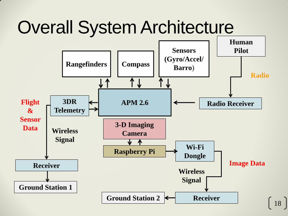
Overall System Architecture
18
APM 2.6
Sensors
(Gyro/Accel/
Barro) Rangefinders
Ground Station 1
Human
Pilot
Radio Receiver
3-D Imaging
Camera
Radio
Flight
&
Sensor
Data
Image Data Receiver
3DR
Telemetry
Raspberry Pi
Ground Station 2
Wi-Fi
Dongle
Receiver
Wireless
Signal
Wireless
Signal
Compass

Flight Control Software
• Runs on ArduCopter V3.1.2
Quad Configuration
• Works in conjunction with
APM Mission Planner
-Simple configuration and
calibration
-Displays vehicle status
-Displays and monitors
various sensor data
19

Software (cont.)
20
• Vehicle Status

SCENECT
• The SCENE software family is a comprehensive 3D point
cloud processing and managing software for users
• SCENECT by Faro allows the use of 3D Imaging Camera
sensor to capture objects and environments in 3D in real-time
• Allows the users to view, process and analyze recordings
• Can export to different formats for use in third party
applications, like CAD programs
21

3D Reconstructed Room - Using SCENECT, 3D image reconstruction of a room was
mapped
22

Obstacle Avoidance
• Use of rangefinder sensors to detect obstructions within the
vehicle’s path.
• Reflected signals from the rangefinder discovers the
position and distance
• Six rangefinders will be implemented within the system
• Aligned within half angles of each other to retrieve a clear
resolution of an obstacle
23

Obstacle Avoidance (cont.)
24

Autonomous Flight
• Can be used in any
environment
• Uses barometer, magnetometer,
gyroscope, accelerometer, and
range finder to follow the
assigned path
25
Conclusion
• Obstacle avoidance allows for the safe navigation of
autonomous UAV systems in various environments
• Implementation of SLAM into UAV systems provides
ground work for future applications.
• Mapping of unknown environments
• Creating virtual models of large regions or objects
26

Future Work
• Refinement of Obstacle Avoidance system
• Weight reduction of overall system
• Improvement of overall flight endurance
27

Acknowledgements
• Aerospace Engineering
• Dr. Subodh Bhandari
• Hovig V. Yaralian
28

Questions?
29