q8380080125 mojave national preserve
TRANSCRIPT
Q8380080125 Mojave National Preserve
REACTIVATION OF WELLS FOR RESEARCH INTO RESPONSES OF MULE DEER TO EXPERIMENTAL
MANIPULATION OF WATER SOURCES IN MOJAVE NATIONAL PRESERVE
Five wells have been selected for reactivation as part of a research project into mule deerresponse to artificial water. The research proposal is available at
http://www.nps.gov/moja/naturescience/upload/kstewart%20mojave%20proposal.pdf
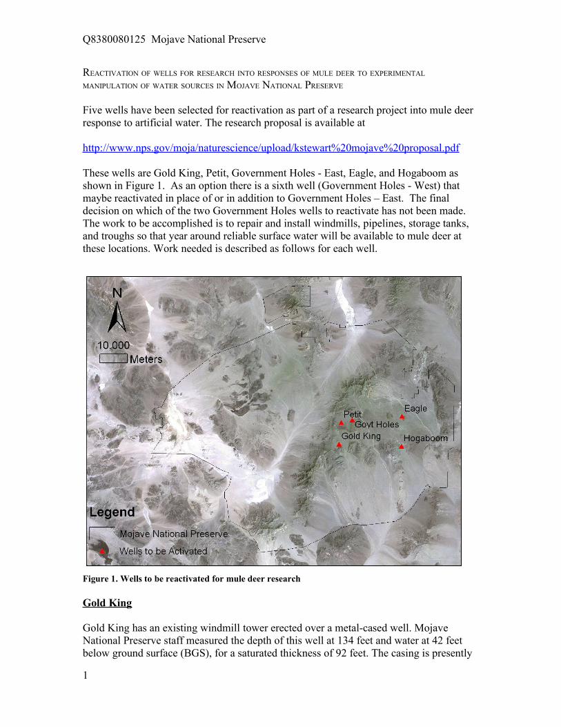
These wells are Gold King, Petit, Government Holes - East, Eagle, and Hogaboom asshown in Figure 1. As an option there is a sixth well (Government Holes - West) thatmaybe reactivated in place of or in addition to Government Holes – East. The finaldecision on which of the two Government Holes wells to reactivate has not been made.The work to be accomplished is to repair and install windmills, pipelines, storage tanks,and troughs so that year around reliable surface water will be available to mule deer atthese locations. Work needed is described as follows for each well.
Figure 1. Wells to be reactivated for mule deer research
Gold King
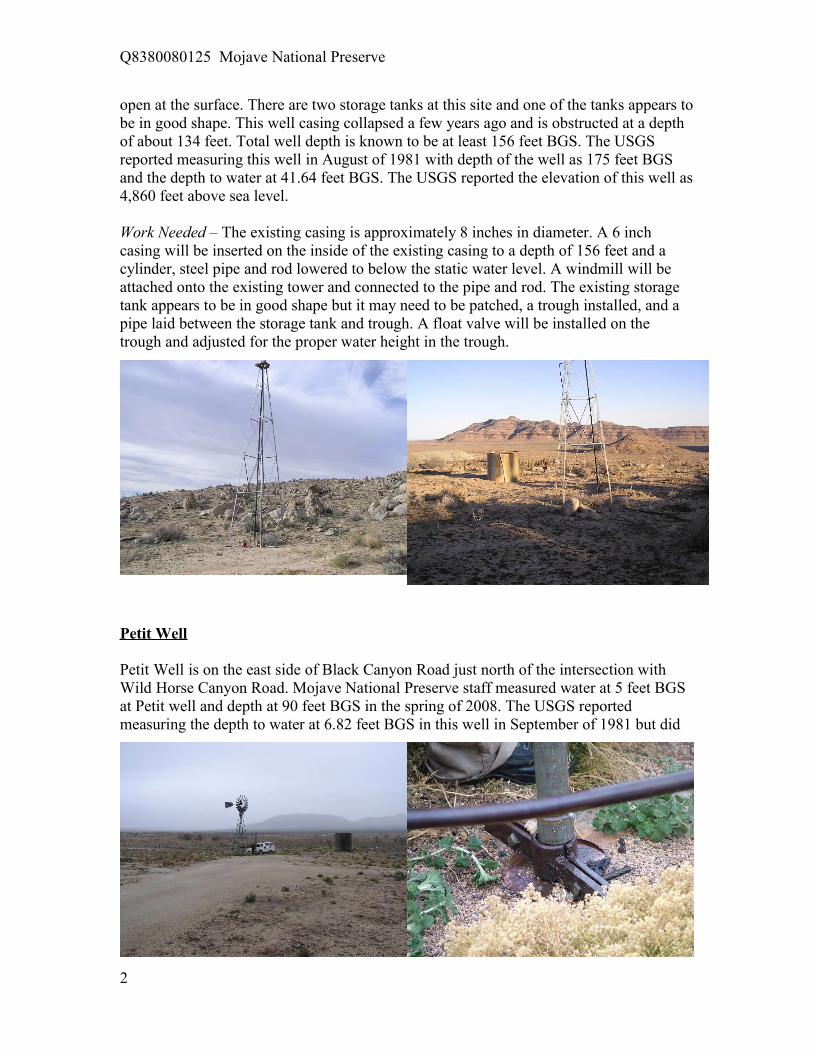
Gold King has an existing windmill tower erected over a metal-cased well. MojaveNational Preserve staff measured the depth of this well at 134 feet and water at 42 feetbelow ground surface (BGS), for a saturated thickness of 92 feet. The casing is presently
1
Q8380080125 Mojave National Preserve
open at the surface. There are two storage tanks at this site and one of the tanks appears tobe in good shape. This well casing collapsed a few years ago and is obstructed at a depthof about 134 feet. Total well depth is known to be at least 156 feet BGS. The USGSreported measuring this well in August of 1981 with depth of the well as 175 feet BGSand the depth to water at 41.64 feet BGS. The USGS reported the elevation of this well as4,860 feet above sea level.
Work Needed – The existing casing is approximately 8 inches in diameter. A 6 inchcasing will be inserted on the inside of the existing casing to a depth of 156 feet and acylinder, steel pipe and rod lowered to below the static water level. A windmill will beattached onto the existing tower and connected to the pipe and rod. The existing storagetank appears to be in good shape but it may need to be patched, a trough installed, and apipe laid between the storage tank and trough. A float valve will be installed on thetrough and adjusted for the proper water height in the trough.
Petit Well
Petit Well is on the east side of Black Canyon Road just north of the intersection withWild Horse Canyon Road. Mojave National Preserve staff measured water at 5 feet BGSat Petit well and depth at 90 feet BGS in the spring of 2008. The USGS reportedmeasuring the depth to water at 6.82 feet BGS in this well in September of 1981 but did
2

Q8380080125 Mojave National Preserve
not report a depth for the well. This well could be activated by repairing the windmill andlowering a polyethylene storage tank down inside the existing corrugated metal tank. TheUSGS reported the elevation of this well as 5,270 feet above sea level.
Work Needed – This windmill needs a new tail spring, Pitman rod, platform, oil, brakehandle, brake wire, and leathers for the cylinder. A polyethylene storage tank will be fitinside the existing corrugated metal tank and piped from the windmill riser.Approximately 400 feet of flexible pipe is needed to connect the storage tank to thetrough. The trough will need a new float valve, a cover built, cleaned and drained.
Government Holes - East
The windmill tower at Government Holes –East sits over an open, hand-dug well severalfeet wide. This creates a hazardous condition where animals or humans can fall in.Mojave National Preserve staff measured the water level at 8 feet BGS in spring of 2008.Total well depth is 28 feet BGS. There is an existing concrete tank about 300 feet or sodown gradient but there does not appear to be any pipe. The USGS has data on this wellstarting in 1917. According to the USGS, this well is 30 feet deep. The USGS recordedthe water levels as 15 feet BGS in 1917, 26 feet BGS in 1953, 22 feet BGS in 1955, 26feet BGS in 1958, 26 feet BGS in 1960, and 9 feet BGS in 1981. The USGS reported theelevation of this well as 5,040 feet above sea level. Work at site this site includesrepairing the windmill in keeping with the historic setting, covering the open hole, andinstalling a low profile polyethylene storage tank inside the existing corrugated metalstorage tank.
Work Needed – This windmill needs a new bonnet, oil, Pitman rod, and leathers for thecylinder. A well cover needs to be constructed over the open pit well and the existingtrees trimmed back. A low profile polyethylene tank will be lowered into the existingcorrugated metal tank and piped to the existing concrete trough with about 300 feet offlexible pipe. The concrete trough needs to be patched, cleaned, and the float valveadjusted.
3

Q8380080125 Mojave National Preserve
Eagle Well
Eagle well is located in Lanfair Valley approximately 2 ½ miles east of Ivanpah Road.The USGS reported the elevation of this well as 3,980 feet above sea level. There is a
windmill tower at the site but no fan, head, or pipe. The well head is welded shut. USGShas data on this well starting in 1937. According to the USGS, Eagle well is 700 feetdeep. The USGS recorded the water levels as 570 feet BGS in 1937, 518 feet BGS in1980, 510 feet BGS in January 1980, 521 feet BGS on September 1980, and 510 feetBGS in November 1983. There are two corrugated metal storage tanks at the site in poorcondition. The well and casing are at least 70 years old.
Work Needed – A polyethylene storage tank will be installed inside one of the existingcorrugated metal storage tanks and piped to a trough. Flow from the storage tank to thetrough will be by gravity controlled at the trough with a float valve. Water will be hauledto the site and pumped into the storage tank but not as part of this contract.
Hogaboom Well
The only structures remaining at the site of the Hogaboom (Vontrigger) well are threemetal cased boreholes. These three cased boreholes are located approximately 500 to
1000 feet from Lanfair Road in LanfairValley. The USGS reported the elevation ofthese wells as 3,590 feet above sea level.Two of boreholes are open and the thirdborehole has a piece of metal welded overthe top of it. This well, closest to LanfairRoad, is the one to be reactivated. Thediameter of the casing is about 6 inches.The depth of the well was measured at149.3' BGS and water was measured at 69.6feet BGS in the spring of 2008. A completewindmill with a tower, propeller, rods andpipes will be erected over the 149.3 feetdeep most westerly well.
4

Q8380080125 Mojave National Preserve
Work Needed – A new or used steel windmill tower will be erected over the existingmetal cased well. A smaller diameter PVC or steel casing will be perforated through thesaturated interval and inserted down the inside of the existing casing. A windmill will beinstalled on the tower and a cylinder, steel pipe, and rod lowered down to below staticwater level. The well riser will be connected by pipe to a polyethylene storage tank. Thestorage tank will then be piped to a trough equipped with a float valve.
Government Holes – West (optional well)
The only structure remaining at the site of the Government Holes - West well is a 6 inchdiameter metal cased borehole that sticks up about 1 foot above the ground surface. Ametal plate has been welded to the top of the casing and there is a hole in the side of thecasing for checking the water level of the well. The cased borehole is approximately2,300 feet to the west of the Government Holes – East well. The USGS reported theelevation of this well as 5,060 feet above sea level. The depth of the well was measured at94.1feet BGS and water was measured at 16.6 feet BGS in the spring of 2008. The USGSreported measuring this well in the summer of 1981. They reported the depth of the wellas 147 feet BGS and water was measured at 29.4 feet BGS. If the option to reactivate thiswell is exercised, then a complete windmill with a tower, propeller, rods and pipes will beerected over the 94 feet deep well.
Work Needed – If the option to reactivate this well is exercised, then a new or used steelwindmill tower will be erected over the existing metal cased well. A smaller diameterPVC or steel casing will be perforated through the saturated interval and inserted downthe inside of the existing casing. A windmill will be installed on the tower and a cylinder,steel pipe, and rod lowered down to below static water level. The well riser will beconnected by pipe to a polyethylene storage tank. The storage tank will then be piped to atrough equipped with a float valve.
5