pwm1 s15/0383 /mjnf target decision date: committee...
TRANSCRIPT

1
PWM1 S15/0383/MJNF Target Decision Date:
Committee Date: 02-Jul-2015 23-Jun-2015
Applicant Mr W Cheung, Big60Million Ltd Thorney Weir House, Thornley Mill Road, Iver, Buckinghamshire, SL0 9AQ
Agent
Proposal Installation of solar farm (14.82ha) and associated equipment and infrastructure.
Location Land south-east of Pasture Farm, Allington Lane, Allington, Grantham, NG32 1EQ
App Type Major Full (Non-residential)
Parish(es) Barrowby Great Gonerby
Reason for Referral to Committee
The application has been referred to Committee at the request of the Vice Chairman due to the scale and nature of the proposal.
Recommendation Approved subject to condition(s)
Key Issues
• The Council needs to consider whether the public benefits of a new source of renewable energy outweigh the environmental impacts - in particular the landscape/visual impact and heritage impact.
Technical Documents Submitted with the Application
• Design and Access Statement
• Heritage Impact Assessment
• Archaeological Evaluation Report
• Historic Maps and Geophysical Report
• Ecological Appraisal
• Agricultural Land Report
• Decommissioning Method Statement

2
• Flood Risk Assessment
• Landscape and Visual Impact Assessment
• Glint and Glare Assessment
• Transport Statement
• Statement of Community Involvement
• Construction Method Statement
• Alternative Site Assessment

3
REPORT 1.0 Application Category 1.1 This application is categorised as a major application for planning permission. 2.0 Reason for Referral to Committee 2.1 The application has been referred to Committee at the request of the Vice Chairman due to the
scale and nature of the proposal. 3.0 The Site 3.1 The application site comprises the whole of one field which is roughly triangular in shape and a
small rectangular section of the adjacent field. The area is approximately 14.82ha. There are hedgerows partially surrounding the site.
3.2 The site lies on gently sloping agricultural land between the villages of Allington, Great Gonerby,
Sedgebrook, and Barrowby. It is respectively 2.4km, 1.2km, 1.9km and 2km from each of these villages. The A1 trunk road passes approximately 100m to the eastern corner of the site with the Gonerby Moor commercial area beyond, and the Grantham to Nottingham railway line runs along the southern boundary.
3.3 In terms of topography, the immediate landscape is generally flat or gently undulating with the
escarpment of the Gonerby ridge running north east to south west rising dramatically from the vale – about 400m away at its nearest point. Allington village is on a much less pronounced low ridge to the northwest.
4.0 The Proposal 4.1 The proposal is for a solar farm and associated structures and equipment which would have an
estimated installed capacity of 5MW. Detailed drawings have been submitted for all the proposed equipment, buildings and structures which include:
• Rows of panels, set at 15 degrees running east to west, with a maximum height of 2.5m. Arrays would be spaced approximately 5.1 -6.7m apart
• 3 x Power Conditioning Units (“PCUs”).
• 1 x DNO Transfer Station
• 1 x Collecting Station
• 2 x Energy Storage Containers
• 1 x General Storage Container
• Perimeter Fencing (maximum 2m high).
• PADCON Monitoring System of Solar Modules.
• Wind and Irradiation Sensors
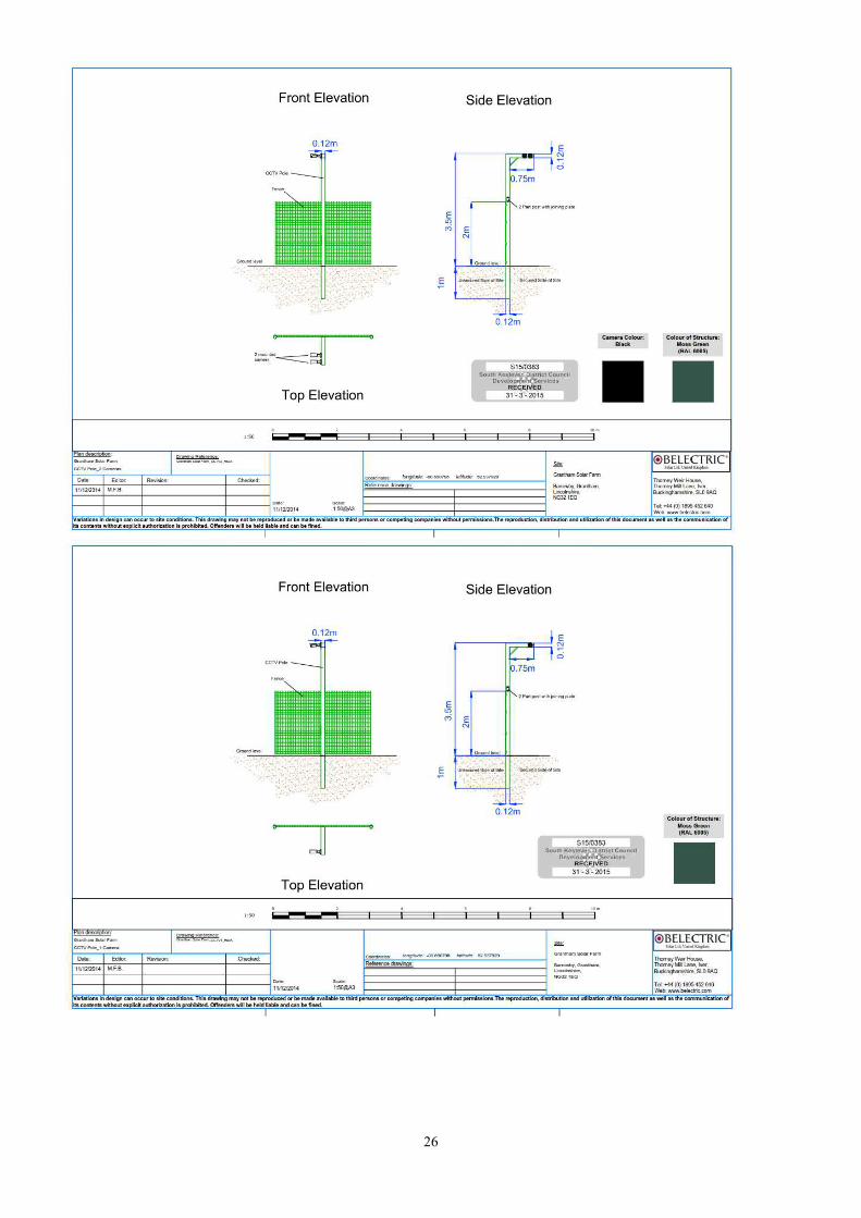
• CCTV Monitoring System (20 no. of 3.5m high pole-mounted cameras).
• Temporary Construction Compound
• Underground cabling.
• Vehicular access onto Allington Lane to the west
4.2 In addition to the physical structures on site, a comprehensive landscaping scheme as well as a Landscape, Biodiversity and Agricultural Management Plan (LBAMP) have been submitted in support of the application. Landscaping includes retention and enhancement of existing hedgerows, planting of new hedgerows around the perimeter and the planting of numerous native

4
trees within the hedgerows. The land within the site would be planted with appropriate grass species to enhance biodiversity and the land between the arrays would be used for sheep grazing.
4.3 Permission is sought for a temporary period of 30 years, after which the solar farm would be decommissioned and the site returned to its former condition.
4.4 The connection to the grid is proposed to be via an underground cable running approximately
1km north to Gonerby Lane. 5.0 Evaluation 5.1 Main Issue 5.1.1 The Council needs to consider whether the public benefits of a new source of renewable energy
outweigh the environmental impacts - in particular the landscape/visual impact and heritage impact.
5.2 Contribution of the Development to Renewable Energy – The Principle of Development 5.2.1 Taking into account the policies outlined in section 14 of this report, it is clear that there is strong
policy support at both national and local level for solar energy proposals in principle, although clearly there is not an automatic presumption that all locations will be appropriate. As the government’s Planning Practice Guidance for Renewable and Low Carbon Energy (PPG) makes clear, the need for renewable or low carbon energy does not automatically override environmental protections.
5.2.2 Of particular relevance are the following paragraphs in NPPF:
Para 97: To help increase the use and supply of renewable and low carbon energy, local planning authorities should recognise the responsibility on all communities to contribute to energy generation from renewable or low carbon sources. They should:
• have a positive strategy to promote energy from renewable and low carbon sources
• design their policies to maximise renewable and low carbon energy development while ensuring that adverse impacts are addressed satisfactorily, including cumulative landscape and visual impacts
Para 98: When determining planning applications, local planning authorities should not require applicants for energy development to demonstrate the overall need for renewable or low carbon energy and also recognise that even small-scale projects provide a valuable contribution to cutting greenhouse gas emissions; and approve the application if its impacts are (or can be made) acceptable.
5.2.3 Policy EN3 of the CS is supportive in principle of renewable energy schemes stating that such
schemes will be approved subject to compliance with other CS policies and national guidance. 5.2.4 To summarise, the overall need for renewable energy through proposals of all sizes and types,
and in appropriate locations has already been established and is enshrined in planning policy and does not need to be revisited when assessing individual planning applications.
5.2.5 The proposal is solar farm which would provide a new source of renewable energy that would
make a valuable contribution to meeting national targets, reducing greenhouse gas emissions and providing energy security, which are important public benefits.
5.2.6 These public benefits of the development (as enshrined in national and local planning policy) should therefore be given significant weight when balanced against the environmental impacts.

5
5.2.7 The PPG makes it clear that the weight given to public benefits should reflect the amount of energy produced. At approximately 5MW, the amount is fairly high. Therefore significant weight should be given to the public benefit when balanced against the environmental impacts.
5.3 Use of Agricultural Land 5.3.1 Taking into account the policies and guidance outlined in section 8 of this report, it is clear that
there is support for the general desirability of reusing brownfield land in preference to greenfield. However there is no blanket ban on the use of greenfield land. There is a limited amount of brownfield land available and it is not distributed evenly across the country with rural areas having much more limited supply. There are numerous types of development proposed with a need for land and there is insufficient brownfield land available or suitable at any one time to accommodate all development needs. In addition, large scale ground mounted solar farms have very specific requirements in terms of the type of site needed, which further limits the availability of suitable brownfield sites.
5.3.2 In respect of locating large scale ground mounted solar farms on greenfield agricultural land,
there has been some uncertainty about how the NPPF and other guidance should be interpreted and this Council has previously refused a number of solar farms on the grounds that the need to use greenfield land had not been demonstrated in accordance with NPPF para 112. Three of these proposals are currently under appeal (S14/0731 – Highfield farm, West Willoughby, S14/1084 – Honington Heath and S14/0430 – Highfield farm, Great Gonerby). A fourth, S13/3273 – Copley Farm Claypole has recently been allowed on appeal. More recently the Council has granted permission for two solar farms S14/2290 – Copley Farm, Claypole (smaller version of S13/3273) and S15/0194 – Gonerby Lane, Allington.
5.3.3 NPPF para 112 states: “Local planning authorities should take into account the economic and
other benefits of the best and most versatile agricultural land. Where significant development of agricultural land is demonstrated to be necessary, local planning authorities should seek to use areas of poorer quality land in preference to that of a higher quality.”
5.3.4 The PPG expands on this, stating that LPAs will need to consider “where a proposal involves
greenfield land, whether (i) the proposed use of any agricultural land has been shown to be necessary and poorer quality land has been used in preference to higher quality land; and (ii) the proposal allows for continued agricultural use where applicable and/or encourages biodiversity improvements around arrays.”
5.3.5 Within South Kesteven, the inspector clarified the situation stating in the recent appeal decision
at Copley Farm, Claypole: “The Council argues that the Appellants have not demonstrated that other sequentially preferable land is not available and has mentioned the government’s Solar PV Strategy Part 2 which emphasises the priority for utilising south facing commercial roofspace rather than greenfield agricultural land. Whilst the use of commercial roofspace and derelict land is clearly preferable the government’s strategy does not rule out the use of agricultural land for the siting of solar PV schemes to generate renewable energy. Furthermore, it is intended that the land would continue in agricultural use, almost certainly for the grazing of sheep, and the Council has suggested a condition to this effect. The proposed solar farm development would not be on BMV land and the land would remain in agricultural use. The development would not thus result in an unacceptable loss of agricultural land.”
5.3.6 There have also been a number of recent appeal decisions from around the country, which have
generally taken the same approach to the use of greenfield land, and which are material considerations which help to give some further clarity.
5.3.7 Firstly, inspectors have taken different approaches as to whether a solar farm can be described
as “significant development of agricultural land” depending on the circumstances. In some cases the scale of the site and visual impact has led them to conclude that it is. In other cases the view has been taken that when land would continue to be used for agriculture such as sheep grazing

6
in conjunction with the solar arrays, it is not. In addition the fact that solar arrays are temporary and easily reversible, it has been concluded that it is not significant irreversible development in the same sense as a quarry, or residential or commercial built development. However the PPG advises LPAs to consider whether the use of greenfield land has been demonstrated to be necessary for solar farms, so it is reasonable to conclude that for large scale schemes, significant development of agricultural land does occur for the purposes of NPPF para 112.
5.3.8 Most (although not all) recent appeal decisions have concluded that there is a general
presumption against the use of best and most versatile land (grades 1 – 3a) for solar farms unless there is overriding justification. For example if it has been clearly demonstrated that there is a lack of poorer quality land within a reasonable area of search. Furthermore, the former Secretary of State has now confirmed that this is the government’s approach stating in the March Planning Update Ministerial Statement “we want it to be clear that any proposal for a solar farm involving the best and most versatile agricultural land would need to be justified by the most compelling evidence.”
5.3.9 In order to demonstrate that the use of greenfield land is necessary, it is good practice (although
not explicitly required by policy) to apply a sequential test. N.B the PPG guidance specifically refers the factors to consider for large scale ground mounted solar farms so it can reasonably be assumed that only large brownfield sites that could accommodate such proposals need to be considered in preference to greenfield rather than commercial rooftops etc which are applicable to a different type/scale of solar development. The applicants have clearly set out in their submission the rationale behind their site selection. Greenfield land is proposed because they have identified a lack of suitable brownfield sites or lower quality land locally for large scale ground mounted solar farms. Factors such as the availability of grid connections and environmental concerns are also important, leading to the conclusion that there are very few suitable sites in any given area. The lack of available suitable brownfield sites is backed up by the Council’s own database. Furthermore, a recent appeal decision for a solar farm in Sussex looked at this issue in great detail and concluded that there is nothing in policy which requires a sequential test as long as the land is not BMV land. Taking the above into account it is considered that the proposal meets the first test of NPPF para 112.
5.3.10 The government’s Agricultural Land Classification classifies the land as Class 3
(undifferentiated). In support of their application, the developer has commissioned a site specific assessment by a suitably qualified independent professional (ARUP and Soil Environmental Services) which has found the land to be class 3b. It is therefore not best and most versatile and is therefore falls within the category of poorer quality land (3b – 5) as defined in National Planning Policy Statement - EN1. The agricultural land classification shows that there is very little land within a wide search area of classes 4 – 5. Furthermore the land between the arrays would continue to be used for sheep grazing. This, together with biodiversity enhancements would improve the overall quality of the land in the long term and weighs in favour of the proposal.
5.3.11 Whilst officers have no reason to doubt the robustness and conclusions of the original land
classification assessment, for the avoidance of doubt, the developer has agreed to submit a second opinion from a separate professional body to confirm that the land is indeed classified as 3b which will be reported in the Additional Items paper to members at the meeting.
5.4 Use of Agricultural Land – Conclusion 5.4.1 The proposal meets the tests of NPPF para 112, read in conjunction with the NPPG guidance
and ministerial statements and in this respect it is considered that there is no fundamental conflict with the NPPF, NPPG or Core Strategy Policies EN1, EN3. (it would also accord with the thrust of the recent appeal decisions)
5.5 Landscape and Visual Impact 5.5.1 A Landscape and Visual Impact Assessment (LVIA) has been submitted with this application
which includes a zone of theoretical visibility (ZTV) and photomontages, and an assessment of

7
the sensitivity of the landscape character, significant views and the nearest receptors and the magnitude of the impacts.
5.5.2 Solar farms often take up large expanses of land, can stand out to varying degrees and
particularly in undulating landscapes cannot be easily hidden. The key issue here is not whether it would be visible, but the degree to which the proposed development would have an impact on quality and character of the landscape and important views within that landscape.
5.5.3 As the PPG advises, the impact on the landscape character and visual impacts are best
considered separately. Landscape effects are concerned with the way in which a proposal would affects the fabric, quality and character of a landscape and the degree to which it would become a significant or defining feature of that landscape. Visual impacts concern the degree to which particular views or receptors experiencing those views would be affected.
5.5.4 The site lies within “The Trent and Belvoir Vales” character area, which is described as a
relatively simple, medium to large scale open arable and mixed farming landscape. The gentle landform and farmland creates a strongly rural feel and the village church towers and spires are noticeable in views across the landscape and provide character. Having said that, this is a relatively broadbrush assessment and not all parts of the vale display these characteristics, some being more or less sensitive. It is considered that the submitted LVIA is generally correct in its assessment of the magnitude of the landscape and visual impacts.
5.5.5 In terms of the baseline landscape character and sensitivity of this part of the Vale, the
application site is at the edge of the flatish vale floor. The land gently slopes up towards the foot of the scarp. In the immediate area there are few individual landscape features of intrinsic sensitivity although distant features such as Belvoir Castle and All Saint’s Church Barrowby do to a limited extent contribute positively to the landscape character. The area has the character of farmland on the urban fringe of Grantham adjacent to the A1 corridor. The immediate landscape consists of intensively cultivated arable land and whilst some of the original field pattern dating from Parliamentary enclosures remains, many hedgerows have been removed and fields enlarged for more intensive farming. In addition, to some extent, and more so than in other parts of the vale, there are a number of long established urbanising features and visual detractors that define the character of the area. These include the A1 trunk road and Gonerby Moor Interchange, Gonerby Moor commercial area, the Arena UK equestrian complex, large scale commercial buildings at Toll Bar Road, Marston, multiple railway tracks and high voltage power lines. In terms of the wider context, the site is relatively close to the steeply sloping ridges of the Gonerby/Grantham/Barrowby escarpment which forms the eastern/southeastern boundary of the vale. Despite the topography, which offers extensive panoramic views of the vale, the landscape is not statutorily designated as an area of outstanding natural beauty and therefore is not deemed to be of the highest quality or to warrant the highest degree of protection. Taking the above into account, this part of the Vale is considered to be of relatively low sensitivity to this type of development.
5.5.6 The land on which the solar farm would be situated is on a gentle north facing slope and whilst it
could not be wholly screened, the visual impact would be largely contained within a very localised area within a radius of about 1.5km, and even then it would be mainly seen in the context of the adjacent urban fringe. It would not be easily visible beyond this distance from within the vale itself due to intervening vegetation and buildings. The proposal would retain and enhance the existing historic field pattern and boundary features and would not result in the loss of any significant landscape features. However, because of the panoramic views from the escarpment, there would be some long distance views of the solar farm. The submitted photomontages show that the main difference from the existing view would be the colour and it would form a small component of the landscape in the middle distance, sitting within the existing field pattern, in the context of the modern influences described above. It would not appear so dominant as to become a defining feature in the landscape as a whole or to fundamentally change its overall character.
5.5.7 Government guidance indicates that the cumulative impact of renewable energy developments
should be considered and that the approach to assessing cumulative impacts of solar farms is

8
likely to be similar to that of wind turbines. There are a number of existing renewable energy developments in the area which have the potential to create a cumulative impact. These include an operational solar farm at Marston, a recently approved 11ha solar farm at Gonerby Lane, a 74m wind turbine at Green Lane Marston, a 69m wind turbine at Frinkley Farm, Hougham and a 35m wind turbine at Pasture Farm, Allington. The Marston solar farm is not easily visible from public vantage points so there would be no cumulative impact in that case. Cumulative impacts from the Gonerby Lane solar farm would only be experienced from long distance vantage point on the Gonerby and Barrowby ridges where both solar farms would be distant features within an urban fringe landscape characterised by many modern human influences. The abovementioned wind turbines would be seen together with the proposed solar farm from a limited number of mainly long distance viewpoints. However, they would be seen as relatively distant individual features in the wider landscape. Overall the proposal would not cumulatively result in a landscape dominated by renewable energy developments.
5.5.8 Turning to specific views within the landscape and the impact on receptors (including views
experienced by recreational users of the countryside, drivers and local residents). Within the vale the solar farm would be a low key feature set within a large scale landscape from most public vantage points. Users of the bridleway which runs from Gonerby Lane to the boundary of the site would experience some visual intrusion in an otherwise agricultural landscape although screening from hedgerows and trees would soften the impact. The proposed solar farm would be visible from public vantage points and PROWS along the Gonerby Ridge and the fringes of the Barrowby village. However from these locations it would be a distant feature, well integrated with the overall landscape, and as such it would not appear unduly overbearing, prominent or visually intrusive. The solar farm would be visible from passing trains and motorists on the A1 may be able to glimpse it through gaps in the hedgerow . However these receptors are of relatively low sensitivity given that this would be a very small part of their overall journey experience.
5.6 Landscape and Visual Impact - Conclusion 5.6.1 The proposed solar farm is similar in scale and surroundings to the recently approved Gonerby
Lane Solar farm approximately 1km to the north (S15/0194). However the current proposal being on gently sloping rather than flat land and closer to the Gonerby Ridge is in a slightly more sensitive location in landscape terms as it would be more difficult to wholly screen the site. Nonetheless it is significantly smaller than the 52ha Copley Farm scheme at Claypole (S13/3273), which was recently allowed on appeal. Whilst there are some similarities, it is considered that the landscape sensitivity and impact of the current scheme is less than that of Copley Farm. There would however be a minor adverse landscape/visual impact on the immediate area occupied by the solar farm and surrounding it, extending to a radius of about 1.5 km but this to some degree would be softened by new planting. Beyond this the landscape/visual impact would be negligible and it would not (including cumulatively with other nearby solar farms) become the defining feature in the wider landscape. CS Policy EN1, read in conjunction with CS policy EN3 can reasonably be interpreted as requiring that a renewable energy proposal can contribute to the overall conservation of its context even if there are some limited localised adverse effects as there will always be with renewable energy projects. However in this case it is considered that there is some limited conflict with Core Strategy Policy EN1in landscape/visual terms.
5.7 Historic Environment 5.7.1 Sections 66 & 72 of the Planning (Listed Buildings and Conservation Areas) Act 1990 require
decision makers to have special regard to the desirability of preserving listed buildings or their settings or any features of special architectural or historic interest which they possesses as well as the desirability of preserving or enhancing the character or appearance of conservation areas. Any adverse effect on a heritage asset, even if slight or minor, would not preserve the asset.
5.7.2 As was made very clear in the recent judgement of the Court of Appeal in the Barnwell Manor
case, the abovementioned legislation requires that considerable importance and weight must be

9
attached by the decision maker to the desirability of preserving the setting of heritage when balancing harm against public benefits.
5.7.3 The NPPF is very clear that proposals which would result in substantial harm should be refused
unless it can be demonstrated that it is necessary to achieve substantial public benefits that outweigh the harm. Where a proposal would lead to less than substantial harm to the significance of a designated heritage asset, this harm should be weighed against the public benefits of the proposal.
5.7.4 The applicant has submitted a Heritage Impact Assessment (HIA) and an Archaeological
Evaluation Report and officers generally agree with the conclusions of these documents, although any cumulative harm from the recently approved Gonerby lane solar farm (S15/0194) must also be taken into account. The area as a whole is rich in heritage assets although there are none close to the site. In this case, as confirmed in the HIA, the only heritage assets with the potential for their settings to be affected are some distance away and include grade II listed Barrowby Old Hall, grade I listed All Saints Church, Barrowby, grade I listed Belvoir Castle and grade II Belvoir registered Park and Garden and the conservation areas at Allington and Barrowby. Any others in the area are considered to be either out of view or too far away to be affected by the proposed solar farm.
5.7.5 There would be some very limited views in which the abovementioned heritage assets could be seen together with the solar farm, in most cases in the context of a landscape to some extent characterised by other modern development and overhead power lines. In respect of the church and Old Hall at Barrowby and Belvoir Castle and park/gardens, whilst they do have an extended countryside setting, the separation distances are so great that any impact would be very minor. There are some viewpoints to the north looking towards Barrowby where the solar farm would be partially visible in the middle distance with the Barrowby ridge beyond and All Saints Church on the horizon, but landscaping would help to mitigate this to some degree. The setting of Belvoir Castle, insofar as it is affected by this proposal also includes the panoramic view from the terrace across the vale. As was established in the Thackson’s Well wind farm appeal, the significance of this view, lies in its breadth rather than any particular feature within it. Equally, panoramic views across the vale out of Barrowby conservation area are noted as “key views” in the Barrowby Conservation Area Appraisal. However, the solar farm would be an insignificant component of the landscape in the middle distance and would not unduly harm theses views in so much as they contribute to the historic setting and therefore the significance of these assets. In respect of Allington Conservation Area, generally views into and out of the conservation area are restricted by more modern development surrounding the historic core of the village which is the main focus of the conservation area.
5.7.6 In respect of archaeology, the applicant’s geophysical survey and trial trench evaluation has
revealed evidence of archaeological remains from the 1st and 2nd centuries AD within the site, but none of such significance as to be worthy of designation. The Community Archaeologist is satisfied that a programme of works condition will ensure research objectives can be achieved and that there would be no adverse impact on archaeology.
5.8 Historic Environment -Conclusion 5.8.1 Taking into account the nature of the development and the separation distances involved, and
the cumulative impact of the approved Gonerby Lane solar farm (S15/0194), there would be no direct impact on archaeological remains, but the proposal would result in minor and less than substantial harm to the setting of heritage assets. And in this respect the proposal conflicts to some extent with Core Strategy Policy EN1. The NPPF test for less than substantial harm which requires the harm to be balanced against the public benefits is applied in the final planning balance.
5.9 Ecology

10
5.9.1 The site lies within an area of intensively cultivated arable farmland with few features of ecological sensitivity. A phase 1 habitat survey has been submitted with the application which concludes that there is a low probability of ecology being detrimentally affected. No further surveys are recommended.
5.9.2 The proposal has been assessed in accordance with Natural England’s standing advice,
consultee responses and the phase 1 habitat survey, and it is considered that the specific characteristics of the site and surrounding area are such that there is a low probability of protected species being affected. No objection has been raised by the relevant consultees including Natural England who are satisfied that by virtue of the scale and nature of the development, no designated sites would be adversely affected. As such in this case it is not considered necessary or appropriate to request any further survey work.
5.9.3 The proposal would result in an enhancement to local biodiversity through new planting and
ceasing of intensive agriculture. A condition has been attached to ensure that an appropriate ecological management plan is submitted and approved and the site is managed to secure the biodiversity benefits. This aspect of the proposal is supported by Natural England and Lincs Wildlife Trust and should be seen as a public benefit of the proposal which weighs in its favour.
5.10 Ecology - Conclusion 5.10.1 Taking the above into account, it is considered that (subject to conditions) the proposal would be
beneficial to wildlife and biodiversity that should be given due weight in the planning balance. And in this respect it is in accordance with the NPPF and Core Strategy Policies EN1 and EN3
5.11 Highways 5.11.1 Vehicular access to the site would be from the A1 and A52. A comprehensive transport
statement has been submitted with the application. The local highways authority are satisfied that subject to a condition requiring delivery of plant and machinery being carried out in strict accordance with this plan, and in particular that all HGVs access the site from the South via the A52 and Allington Lane, and all other traffic via Pasture Farm and Gonerby Lane.
5.12 Other Issues 5.12.1 Residential Amenity: There is a reasonable separation distance from the nearest residential
dwelling and as such it is not considered to be of such magnitude that it would be unacceptably dominant, oppressive or overbearing or otherwise detrimental to residential amenities.
5.12.2 Glint and Glare: Network Rail, the Highways Agency, MOD and NATS have confirmed that they
have no objection in respect of glint and glare. Network Rail have requested a condition which has been attached to ensure that nearby signals are not unduly affected.
5.12.3 Flooding: the EA and drainage consultees have no objection subject to various drainage
conditions and adherence to the flood risk assessment. 5.12.4 Rural Diversification: Planning policy at both the national and local level is supportive of farm
diversification. The proposal is a form of farm diversification which should be given some very limited weight in the planning balance, and as such the proposal accords with Core Strategy Policies E1, EN3 and the NPPF.
5.13 Planning Balance 5.13.1 Planning law requires that applications for planning permission must be determined in
accordance with the development plan, unless material considerations indicate otherwise. As with all large scale renewable energy developments there will inevitably be some adverse impact. In this case the adverse impacts conflict with policy EN1 of the South Kesteven Core Strategy.

11
5.13.2 However, the adverse landscape/visual impact would be minor and localised and can be partially mitigated through new planting. In respect of heritage impact, in applying the NPPF test for less than substantial harm to the setting of heritage assets, in the light of the statutory duty imposed by section 66 and 72 of the Planning (Listed Buildings and Conservation Areas) Act 1990, the very minor degree of harm is considered in this case to be outweighed by the substantial public benefits of the proposal.
5.13.3 The substantial public benefits of this proposal include the creation of a new 5MW source of
renewable energy as well as biodiversity enhancements and continued agricultural use of the land. Taking the above into account, the limited environmental impacts, as well as all relevant material considerations, including the NPPF read as a whole, it is considered that the minor conflicts with development plan policies are outweighed by the substantial public benefits of the proposal. The environmental impact of the proposal is therefore considered to be acceptable and this application is recommended for approval.
6.0 Section 106 Heads of Terms 6.1 No section 106 required. 7.0 Crime and Disorder 7.1 It is considered that the proposals would not result in any significant crime and disorder
implications. 8.0 Human Rights Implications 8.1 Articles 6 (Right to fair decision making) and Article 8 (Right to private family life and home) of the
Human Rights Act have been taken into account in making this recommendation. 8.2 It is considered that no relevant Article of that act will be breached. 9.0 SUMMARY 9.1 The proposed solar farm would provide a significant source of renewable energy, contributing to
a reduction in the use of fossil fuels, and energy security benefits, as well as biodiversity enhancements and continued agricultural use. The limited and localised adverse landscape/visual impact as well as minor less than substantial harm to the settings of heritage assets would result in some conflict with policy EN1 of the South Kesteven Core Strategy. However, in this case there are material considerations that indicate that the application should be approved. Taking all relevant material considerations into account including National Policy Statements - Overarching National Policy Statement for Energy (EN-1) & National Policy Statement for Renewable Energy Infrastructure (EN-3), The National Planning Policy Framework (Section 3 Supporting a prosperous rural economy, Section 12 Conserving and enhancing the historic environment, Section 11 Conserving and enhancing the natural environment, Section 10 Meeting the challenge of climate change and flooding, Section 7 Requiring good design), it is considered that the substantial public benefits of the proposal identified outweigh the provisions of the development plan and the environmental impacts of the proposal are therefore acceptable.
9.2 In reaching the decision the Council has worked with the applicant in a positive and proactive
manner by determining the application without undue delay. As such it is considered that the decision is in accordance with paragraphs 186 -187 of the National Planning Policy Framework.
10.0 RECOMMENDATION:

12
10.1 Approve subject to the following conditions:
1. The development hereby permitted shall be commenced before the expiration of three years from the date of this permission. Written notification of the date of commencement of the development hereby permitted shall be submitted to the Local Planning Authority no later than 14 days after the event. Reason: to comply with the provisions of Section 91 of the Town and Country Planning Act 1990 as amended.
2. The development hereby permitted shall be carried out in accordance with the following list of approved plans submitted as part of the application, unless otherwise agreed in writing with the local planning authority: Site Layout 1:10000 Site Layout 1:2500 Grantham Solar Farm P03 CC RevA Grantham Solar Farm P04 DI RevA Grantham Solar Farm P06 SA RevA Grantham Solar Farm P07 TS RevA Grantham Solar Farm P08 CS RevA Grantham Solar Farm P09 CT RevA Grantham Solar Farm P11 SC RevA Grantham Solar Farm P12 PC RevA Grantham Solar Farm P13 PE RevA Grantham Solar Farm P15 MB RevA Grantham Solar Farm P16 AT RevA Grantham Solar Farm P18 Sensor RevA Grantham Solar Farm P18 FGE RevA Grantham Solar Farm CCTV1 RevA Grantham Solar Farm CCTV2 RevA Grantham Solar Farm P22 PAT RevA All received 31 March 2015 Grantham Solar Farm P14 DNO RevB received 26 May 2015 Reason: To define the permission and for the avoidance of doubt.
3. The development hereby permitted shall be removed in accordance with condition 4 below after a period of 30 years from the date when electricity is first exported from the solar farm to the electricity grid (“First Export Date”). Written notification of the First Export Date shall be submitted to the Local Planning Authority no later than 14 days after the event. Reason: To ensure that the land is returned to it original agricultural use and appearance when the panels are no longer required for electricity generation and to comply with policy EN3 of the Core Strategy.
4. No later than 9 months before the expiry of this permission, a decommissioning and site restoration scheme shall be submitted for the written approval of the Local Planning Authority. The scheme shall make provision for the removal of the solar panels and associated above ground works approved under this permission. The scheme, as approved, shall be implemented within 6 months of the expiry of this permission. For the avoidance of doubt, the expiry of this permission is 30 years from the date when electricity is first exported from the solar farm to the electricity grid (“First Export Date”). Reason: To ensure that the land is returned to it original agricultural use and appearance when

13
the panels are no longer required for electricity generation and to comply with policy EN3 of the Core Strategy.
5. If, as a result of events or conditions within its control after the first export date, the solar farm hereby permitted fails for a continuous period of 12 months to produce electricity for supply to the local electricity grid network, then, unless otherwise agreed in writing by the Local Planning Authority, a scheme for the decommissioning and removal of the panels and any other ancillary equipment, shall be submitted to and agreed in writing by the Local Planning Authority within three months of the end of the cessation period. The scheme shall include details for the restoration of the site. The scheme shall be implemented within 6 months of the date of its agreement by the Local Planning Authority. Reason: To ensure removal of redundant equipment in the interests of amenity and protection of the local environment in accordance with the NPPF and policy EN1 of the South Kesteven Core Strategy.
6. Notwithstanding the provisions of the Town and Country Planning (General Permitted Development) Order 1995 (or any order revoking or re-enacting that Order with or without modification), no access track or means of enclosure other than those expressly permitted pursuant to condition 2 shall be constructed. Reason: The Local Planning Authority considers that further development could cause detriment to the character of the area, and for this reason would wish to control any future development, and in accordance with Policy EN1 of the adopted South Kesteven Core Strategy (July 2010).
7. The development shall be carried out in accordance with the submitted Landscape, Biodiversity and Agricultural Management Plan (LBAMP) in conjunction with the amended Landscape and Biodiversity Masterplan received 05 June 2015. Reason: In the interests of the ecology and visual amenity of the area and to ensure continued agricultural use of the land and in accordance with Policy EN1 of the adopted South Kesteven Core Strategy (July 2010)
8. No external artificial lighting shall be installed during the operational phase of the solar farm unless otherwise agreed in writing by the local planning authority. Reason: To prevent unnecessary light pollution and to ensure a satisfactory appearance to the development and in accordance with Policy EN1 of the adopted South Kesteven Core Strategy (July 2010).
9. No development shall take place within the application site until the applicant has secured the implementation of a programme of archaeological work in accordance with a written scheme of investigation which has been submitted to and approved by the Local Planning Authority. Reason: These details are required prior to commencement to ensure that construction of the final agreed layout will be achieved without adversely affecting archaeological remains on the site.
10. The development shall be carried out in accordance with the approved Flood Risk Assessment and the mitigation measures detailed within the FRA Reason: To reduce the risk of flooding.
11. The delivery of plant, materials and equipment to the development hereby permitted shall be undertaken in accordance with the submitted details of Construction Traffic Management Plan (CTMP) dated 13 May 2015. In particular, only HGV traffic to use Allington Lane, other site traffic to access via Gonerby Lane.
14
Reason: In the interests of safety of the users of the public highway and the safety of the users of the site
12. Within 24 months of the completion and commencement of operations of the development hereby approved in the event of any complaint to the Council from Network Rail relating to signal sighting safety or driver distraction, upon notification to the LPA, the applicant or operator of the solar farm shall within 28 days submit for approval to the Council details of a scheme of remedial measures to address the concerns raised with details of a timescale for implementation of the works. The works shall be carried out in accordance with the approved details and timetable. Reason: To ensure safety of the users of the railway.
Note(s) to Applicant
1. You are advised that the development should be carried out in accordance with the submitted Construction Management Plan.
2. Under the provisions of the Flood and Water Management Act 2010, and the Land Drainage Act. 1991, the prior written consent of the Lead Local Flood Authority (Lincolnshire County Council) is required for any proposed works or structures in any watercourse outside those designated main rivers and Internal Drainage Districts. At this location this Board acts as Agents for the Lead Local Flood Authority and as such any works, permanent or temporary, in any watercourse will require consent from the Board including the access culvert within the site. A consent form is attached for the use of the applicant. (Upper Witham, Witham First District & Witham Third District IDB)
3. Prior to the submission of details for any access works within the public highway you must contact the Divisional Highways Manager on 01522 782070 for application, specification and construction information.
11.0 Background Information 11.1 Consultations
11.2 LCC Highway Authority:
No objection to the application subject to conditions requiring the delivery of plant, materials and equipment to be carried out in accordance with the submitted Transport Statement and in particular, only HGV traffic to use Allington Lane, other site traffic to access via Gonerby Lane.
11.3 Highways England: No objection to the application subject to conditions requiring the delivery of plant, materials and equipment to be carried out in accordance with the submitted Transport Statement
11.4 Heritage Trust of Lincolnshire:
The Community Archaeologist has confirmed that the recommendations of the submitted archaeological report are acceptable and the further work required can be secured by a scheme of works condition.
11.5 Historic England No site specific advice given but note the area in general is rich in heritage assets. Give general advice on heritage considerations for solar farms, noting that in this case it is the historic landscape setting of nearby churches that is most likely to be a key consideration. Advise that the Council should be satisfied that there is sufficient information to assess the impacts and that all heritage assets potentially affected have been included in the HIA. Recommend that the application be determined in accordance with national and local policy and on the basis of the Council’s own specialist conservation advice.
11.6 Lincolnshire Wildlife Trust:
Support the proposed biodiversity enhancements in the Landscape, Biodiversity and Agricultural Management Plan and make further suggestions including planting of additional hedgerows.

15
11.7 Natural England:
No statutory sites affected. Refer to their standing advice.
11.8 Ministry of Defence: No safeguarding objection
11.9 NATS:
No safeguarding objection
11.10 Network Rail: No objection subject to a condition. Note that signals are unlikely to be affected by glint and glare by request a condition requiring remedial measures in the event that impact on signals is noted.
11.11 Environment Agency:
No objection subject to compliance with the mitigation measures in the submitted flood risk assessment.
11.12 Upper Witham Internal Drainage Board:
No objection
11.13 Sedgebrook Parish Council: Object on the grounds of loss of agricultural land, and concerns that acceptance could lead to further losses within the Vale.
11.14 Allington Parish Council:
No comments
11.15 Great Gonerby Parish Council No objection
11.16 Barrowby Parish Council No comments received
12.0 Representations as a Result of Publicity 12.1 The application has been advertised in accordance with the Council’s adopted Statement of
Community Involvement relevant to this type of planning application. 12.2 Neighbours have been notified of the application and a site notice posted. The period for receipt
of comments expired on 15 May 2015. 12.3 3 letters of objection received. A summary of the main concerns are listed below:
• Traffic during construction
• Visual intrusion
• Concerns about great crested newts
• Loss of good agricultural land
13.0 Policy Framework
Planning law requires that applications for planning permission must be determined in accordance with the development plan, unless material considerations indicate otherwise. Relevant national and local policies (and material considerations) in respect of the proposed development are as follows:

16
13.1 National Planning Policy Framework (NPPF)
13.1.1 Achieving Sustainable Development (paras 6 – 10) – Defines the NPPF’s role and the 3 key
elements of sustainable development i.e. economic, social and environmental, making it clear that these 3 elements should not be considered in isolation. It stresses the need adapt to climate change and move to a low carbon economy whilst protecting and enhancing the built, natural and historic environment.
13.1.2 Presumption in Favour of Sustainable Development (paras 11 – 16) - This summarises the key principle of the NPPF that a positive approach to decision taking should be taken and that development that complies with the NPPF and the adopted local plan should be approved without delay.
13.1.3 Core Planning Principles (para 17) – Sets out the overarching principles of sustainable development that should be followed in decision taking. Those relevant to this application include, seeking high standards of design and amenity, supporting the transition to a low carbon economy through the development of renewable energy, promoting mixed use developments by recognising that open land can perform multiple functions, conserving and enhancing the natural environment, reducing pollution and ensuring that developments are appropriate to their context, including the historic environment.
13.1.4 Section 3: Supporting a prosperous rural economy (para 28) – supports a positive approach to sustainable rural development, through expansion of all types of business and enterprise in rural areas, and promoting diversification of agricultural and other rural businesses.
13.1.5 Section 4: Promoting sustainable transport (paras 32, 34) – Developments generating significant movement (in this case during construction) should be supported by a transport statement. Recognises that different solutions that will be necessary in urban and rural areas.
13.1.6 Section 7: Requiring good design (paras 56- 58, 60-61, 63-66) – Requires new development to be of high quality design which is appropriate for the character of the area and the way it functions and makes use of all available opportunities to enhance it. Whilst local distinctiveness is encouraged, planning decisions should not attempt to impose architectural styles or particular tastes and they should not stifle innovation, originality or initiative. Development which promotes high levels of sustainability should not be refused due to concerns about incompatibility with the existing surroundings if it can be mitigated by good design. It is emphasised that good design goes beyond the visual appearance of individual buildings and includes among other things, connections between people and places, and integration with the historic, built and natural environment.
13.1.7 Section 10: Meeting the challenge of climate change, flooding and coastal change (paras 93 - 98) – Outlines the central role of planning in bringing forward a low carbon economy and supports the development of renewable energy as a key part of this. Local planning authorities are expected to have a positive strategy to promote and maximise renewable energy developments while ensuring that adverse impacts are addressed. Local planning authorities are also invited to consider identifying suitable areas to help bring such schemes forward and all communities are expected to contribute towards renewable energy aims. In all cases LPAs are expected to approve applications where the impacts are acceptable or can be made acceptable. Whilst applicants are not required to demonstrate the overall need for renewable energy, in coming to a judgment on whether the impacts are acceptable, the amount of power that would be generated by any individual proposal, together with any other public benefit has to be balanced by the decision maker against the environmental impact. N.B. The acceptability or otherwise of the environmental and other impacts is assessed under other sections of the NPPF as well as Local Plan policies.
13.1.8 Section 11: Conserving and enhancing the natural environment (paras 109, 111, 112, 118, 123) – Requires the protection and enhancement of valued landscapes to be considered and impacts on

17
biodiversity to be minimised (through mitigation where necessary). Any net increase in biodiversity is encouraged. The effective reuse of brownfield land is encouraged. Local planning authorities are required to take into account the economic and other benefits of the best and most versatile agricultural land (grade 1 – 3a) and where significant development of agricultural land is demonstrated to be necessary, local planning authorities should seek to use areas of poorer quality land in preference to that of a higher quality.
13.1.9 Section 12: Conserving and enhancing the historic environment (paras 128-129, 131-132) – Requires local planning authorities to take into account the significance of any heritage assets affected and the impact on their settings, stating that great weight should be given to the conservation of assets – the more important the asset, the greater the weight should be. If harm is caused it should require clear and convincing justification and the relevant tests should be applied.
13.2 National Planning Practice Guidance (PPG) 13.2.1 The Government’s planning practice guidance supports and supplements the NPPF. The
renewable energy section was first introduced in 2013 and announced with a press release entitled “Greater community say on wind turbines and solar farms”. This section of the practice guidance was issued before the other sections as the Government considered there was an urgent need for further guidance and clarification. They were concerned that the NPPF was not being correctly interpreted and insufficient weight had been given to heritage, landscape and other environmental impacts in planning decisions. The guidance was updated in April 2014, and further clarified the guidance on use of agricultural land. It reiterates the strong policy support for renewable energy, in appropriate locations, but expressly makes it very clear that this does not mean that the need for renewable energy automatically overrides environmental protections and the planning concerns of local communities. It also makes it clear that the energy output of a proposal in relation to the environmental impacts, will have a bearing on how much weight is given to the public benefits. The guidance also advises on particular planning considerations for large scale ground mounted solar farms, and how to assess them, including:
• encouraging use of brownfield land,
• ensuring that for greenfield land i) the use of agricultural land has been shown to be
necessary, and poorer quality land is used in preference to higher quality, ii) the proposal
allows for continued agricultural use where applicable and/or encourages biodiversity
improvements around arrays
• recognising that solar farms are temporary and reversible
• minimising glint and glare to aircraft
• the need for security measures
• minimising the impact on the historic environment
• the potential to mitigate landscape and visual impact through landscaping
13.2.2 The PPG is also relevant to the general consideration of other specific issues such as heritage,
green energy, natural environment etc and is a material consideration.
13.3 Overarching National Policy Statement for Energy (EN-1) 13.3.1 Sets out the government’s overarching planning policy for energy developments. Whilst primarily
intended for nationally significant infrastructure projects, section 10 of the NPPF states that in determining applications, LPAs should follow the approach set out in this document (read in conjunction with EN-3 below). Clarifies that grades 3b - 5 agricultural land are poorer quality that should be used in preference to best and most versatile land (grades 1 – 3a).
13.4 National Policy Statement for Renewable Energy Infrastructure (EN-3)

18
13.4.1 Sets out the government’s planning policy for renewable energy. Whilst primarily intended for nationally significant infrastructure projects, and drawn up before large scale solar developments became part of the renewable energy mix, it is relevant in many respects and read in conjunction with EN-1 above is a material consideration. It is recognised that large scale renewable energy schemes will inevitably have some adverse impacts and that they are generally temporary and reversible.
13.5 South Kesteven Local Plan - Core Strategy 2010: 13.5.1 Policy SP1: Spatial Strategy - This policy directs most new developments to sustainable locations
including the towns and local service centres, restricting development in rural areas. However rural diversification projects are supported.
13.5.2 Policy EN1: Protection and Enhancement of the Character of the District – Requires that development must be appropriate to the character and significant natural, historic and cultural attributes and features of the landscape within which it is situated, and contribute to its conservation, enhancement or restoration. This policy, read in conjunction with CS policy EN3 can reasonably be interpreted as requiring that a renewable energy proposal can contribute to the overall conservation of its context if there are some limited localised adverse effects as it is recognised that there will always be adverse landscape/visual effects with renewable energy projects.
13.5.3 Policy EN3: Renewable Energy - States that the Council will grant planning permission for renewable energy developments subject to compliance with other CS policies and national guidance and subject to the proposal being capable of being either connected to the grid or supplying on site needs, as well as provision of appropriate mitigation of the impacts/emissions and removal of equipment/reinstatement of the land when no longer needed.
13.5.4 Policy E1: Employment Development –Supports rural diversification in the countryside where it meets the needs of farming and other enterprises and has an essential requirement for a rural location.
13.6 South Kesteven Local Plan - Site Allocations & Policies DPD 2014 13.6.1 Policy SD1: Presumption in Favour of Sustainable Development – This policy reflects the
emphasis of the NPPF towards a positive approach to approving appropriate policy compliant development without delay
13.6.2 Policy SAP4: Business Development in the Countryside (Including Rural Development Schemes)
- Supports rural/farm diversification in the countryside that helps to support the local economy. 13.7 National Landscape Character Area (NCA) 13.7.1 NCAs have been defined by Natural England as an aid to decision makers when assessing
potential landscape impacts of development and are a material consideration. They divide England into 159 distinct natural areas. Each is defined by a unique combination of landscape, biodiversity, geodiversity, history, and cultural and economic activity. Their boundaries follow natural lines in the landscape rather than administrative boundaries. The application site is within the Trent and Belvoir Vales NCA which includes the whole of the vale extending from Grantham as far as Nottingham, Gainsborough and Lincoln.
13.7.2 The NCA is characterised by undulating, strongly rural and predominantly arable farmland,
centred on the River Trent. It is a low-lying rural landscape with relatively little woodland cover, and offers long, open views. However, it is recognised that not all areas are the same and that the character of some areas of the NCA have been strongly influenced by modern development.
13.8 East Midlands Region Landscape Character Assessment 2010 (EMRLCA)

19
13.8.1 This regional level of assessment is designed to add a regional layer to the 159 National Character Areas identified by Natural England and provide a strategic context and framework for more detailed landscape assessments at the county, district and local scales that nest within the larger scale assessments. Given that South Kesteven had already produced a landscape character assessment at the district level, prior to publication of the EMRLCA, it provides an additional evidence base which is a material consideration.
13.8.2 The application site lies with an area defined as the Unwooded Vales which roughly corresponds
with the eastern half of the Trent and Belvoir Vales NCA. Extensive long distance and panoramic views are noted.
13.9 South Kesteven Landscape Character Assessment 2007 (SKLCA) 13.9.1 The LCA is broadly based on the NCA and assesses the landscape character of the district at a
more detailed level. It has been used to inform CS policy EN1 and is a material consideration. It identifies the general characteristics of seven landscape areas within the district, each of which displays distinct characteristics of topography, agricultural usage, field systems and settlement patterns as well as historic building styles. The application site lies within “The Trent and Belvoir Vales” character area although to some extent the neighbouring Grantham Scarps and Valleys, and Denton-Harlaxton Bowl character areas would be affected.
13.9.2 The Trent and Belvoir Vales is described as a gently undulating landform, with shallow ridges
dropping down gently to broad river valleys. It is an open, arable or mixed, farmed landscape, strongly rural in feel, with trimmed hedges and few hedgerow trees; woodlands are only locally significant. There are frequent nucleated villages with red brick houses, roofed with pantiles, and spired churches prominent in long views and adding character. It has a medium to large scale character and it is noted that there are a few major urbanising features including the A1 corridor. The area is described as having medium sensitivity to development with renewable energy schemes likely to be more easily absorbed closer to existing human influences. N.B. the LCA refers to sensitivity to wind energy developments but the same criteria can be applied to solar farms.
13.9.3 The Grantham Scarps and Valleys and Denton-Harlaxton Bowl include the nearby scarps of the
Gonerby and Barrowby Ridges where there is greater sensitivity to development on the scarps themselves and “skylining” from development on the horizon.
13.10 Foston Parish Landscape Character Assessment (FPLCA) 13.10.1 The FPLCA carries some limited weight as a material consideration but it has not gone out to full
public consultation or been examined by an inspector in conjunction with a neighbourhood plan. The majority of the parish is described as “large scale arable” which is largely consistent with the character of the wider Trent and Belvoir Vales and the importance of long distance views emphasised.
13.11 Historic Landscape Characterisation Project for Lincolnshire 13.11.1 This document was published in 2011 by a partnership of English Heritage and local authorities
in Lincolnshire (including SKDC). Its purpose is for use as a tool for decision makers in understanding the historic dimension of the landscape. It describes the modern landscape of the historic county of Lincolnshire in terms of the existing features seen today, and of the historic processes by which they were formed. In respect of the application site, the area as a whole is categorised as the “Trent Valley”, the flat land where the solar farm would be located is described as the “Valley Fens” and the adjacent scarps and ridges are the “West Grantham Farmlands”. The project notes in many areas landscape retains a strong historic quality with several layers of time depth being legible.
13.12 European Union Renewable Energy Directive (RED)

20
13.12.1 This was put in place to help the EU meet its renewables target. Renewables include biomass, wind power, solar power, hydropower, and geothermal energy. In addition at least 10 % of final energy consumption in the transport sector must come from renewables by 2020. Each Member State has an individual target within RED. The UK’s target is for 15%.
13.13 Climate Change Act 2008 13.13.1 The act commits the UK to reducing emissions by at least 80% in 2050 from 1990 levels. 13.14 UK Renewable Energy Roadmap (Updated 2013) 13.14.1 Sets out the government’s strong support for renewable energy as part of a diverse, low carbon
and secure energy mix. Stresses that renewable energy offers the UK a wide range of benefits from an economic growth, energy security and climate change perspective. In respect of solar energy, it states
“The extensive deployment of solar PV across the UK has become increasingly visible to the public at all scales and recently solar received the highest public approval rating of all renewable energy technologies at 85%110. We need to ensure that this level of support can be maintained – including by ensuring that solar PV is appropriately sited. We do however expect on-going deployment of the technology to continue at all scales.”
13.15 UK Solar PV Strategy Part 1 13.15.1 This document, published in October 2013 by the Department of Energy and Climate Change
sets out the government’s vision for the expansion and encouragement of solar energy as part of their overall strategy for power generation. Support is given to large scale ground mounted solar farms as part of the mix, including the benefits of increased biodiversity. However the need to ensure that solar farms are appropriately sited, giving proper weight to environmental considerations is stressed. The strategy is based on the following guiding principles:
I. Support for solar PV should allow cost-effective projects to proceed and to make a cost-effective contribution to UK carbon emission objectives in the context of overall energy goals – ensuring that solar PV has a role alongside other energy generation technologies in delivering carbon reductions, energy security and affordability for consumers. II. Support for solar PV should deliver genuine carbon reductions that help meet the UK’s target of 15% renewable energy from final consumption by 2020 and in supporting the decarbonisation of our economy in the longer term – ensuring that all the carbon impacts of solar PV deployment are fully understood. III. Support for solar PV should ensure proposals are appropriately sited, give proper weight to environmental considerations such as landscape and visual impact, heritage and local amenity, and provide opportunities for local communities to influence decisions that affect them. IV. Support for solar PV should assess and respond to the impacts of deployment on: grid systems balancing; grid connectivity; and financial incentives – ensuring that we address the challenges of deploying high volumes of solar PV.
13.16 UK Solar PV Strategy Part 2 13.16.1 This document, published in April 2014 by the Department of Energy and Climate Change
supplements Part 1 above and sets out the government’s vision for the continued expansion and encouragement of solar energy as part of their overall strategy for power generation. The government have expressed in this document that they would like to see a big expansion of “mid scale” solar development on commercial roofs which is seen as a large and as yet mainly untapped resource. The strategy looks to find ways of encouraging this type of development and

21
removing various constraints which are seen as barriers to mid scale solar developments coming forward. Potential changes include changing the government’s subsidy regime, making more government owned land available and looking at ways to remove other identified constraints. It is very important to note that changes to current planning policy are not proposed and that whilst the strategy confirms that more large scale ground mounted solar farms have come forward than anticipated and potential problems with public perception and support have been identified, such schemes on agricultural land have not been categorically ruled out of the mix. Rather it is a case of looking at ways of shifting the emphasis i.e. the ratio of different types of schemes coming through. The Strategy also reiterates existing planning policy and good practice (including supporting the Solar Trade Association “10 commitments” and the BRE National Solar Centre guidance). Solar Trades Association Commitment 1 states that “we will focus on non agricultural land or land which is of lower agricultural quality”.
13.17 Ministerial Statement by Secretary of State for Communities and Local Government Rt Hon Eric
Pickles MP – Planning Update march 2015 (25 March 2015) 13.17.1 The Secretary of State updated parliament on the progress of the government’s UK PV Solar
Strategy, reiterating the importance of encouraging the use of brownfield land, and announcing new permitted development rights for larger solar arrays on commercial rooftops. He also emphasised the importance of landscape and heritage protections in the NPPF and clarified the need to avoid the use of high quality agricultural land for large scale solar farms. In doing so he confirmed that this refers to best and most versatile land i.e. grades 1 – 3a stating that “In light of these concerns we want it to be clear that any proposal for a solar farm involving the best and most versatile agricultural land would need to be justified by the most compelling evidence.”
13.18 Historic England – Good Practice Advice Notes 2 & 3 13.18.1 Give comprehensive advice on how the significance and setting of heritage assets should be
assessed in decision taking. 13.19 Relevant Local Appeal Decisions 13.19.1 Recently a large scale (52ha) ground mounted solar farm at Copley Farm, Claypole was allowed
on appeal. Although each case must be considered on its own merit, to some extent the inspector’s conclusion in this case is a relevant material consideration, as there are a number of similarities in terms of landscape/heritage sensitivity and impacts.
14.0 Relevant Planning History 14.1 A screening opinion was issued in 2013 (S13/1375) for a much larger scheme of 54.6ha and that
proposal was deemed by the Council to be EIA development. 14.2 Two further screening opinions have been issued in 2014 - S14/0887 (10.5ha) & S14/2664
(14.8ha). Both were deemed not to be EIA. The current proposal is an almost identical to the 14.8ha proposal.
15.0 SKDC Corporate Priorities 15.1 This application supports the “keep SK clean, green and healthy”, and “grow the economy”
strands of the Council’s Corporate Priorities by facilitating the growth of renewable energy business and reducing greenhouse gas emissions.

22

23

24

25
26

27

28

29