puc.sd.gov silt loams,-0 to 1 c004a 3.290 not. prime yes high low no no no moderate percent slooes...
TRANSCRIPT

........ .__. ~ DAKOTA ACCESS/ LLC
DAKOTA ACCESS PIPELINE PROJECT SOUTH DAKOTA ENERGY FACILITY PERMIT
APPLICATION
DOCKET NO. HP14-002
ENERGY FACILITY PERMIT APPLICATION AND
EXHIBITS B-D
M??\iC:0:\1-cm- D f\~L \
Ex~->;or-\- g- DA9L 3 Z: xl,., -\.:, 1-t- C. - DPri?L. ~ z_ 'Xh~b \- D - D A-DL S

( ! ', ;
~ ...... f #. DAKOTA ACCESS,.llC
Exhibit C
Supplementary Tables

TABLE OF CONTENTS
Soil Characteristics for Each Soil Map Unit within the Project Area
Waterbodies Crossed by the Project
Federal and State Listed Threatened and Endangered Species in South Dakota
Page 4
Page 31
Page 44

) Soil Characteristics for Each Soil Map Unit within the
Project Area
·"-··- ~-·._../
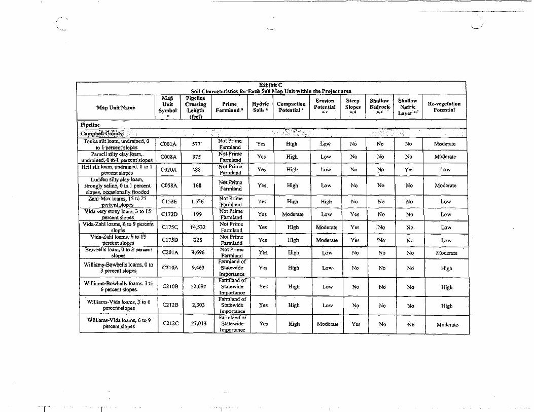
EXbibitC Soil Characteristics for Each S~il-MaD Unit within the Proiect area
Map Pipeline Erosion Steep Shallow Shallow Re-vege~tion Unit CJVSsing Prime HydJic Compaction
Potential Slopes Bedrock Natrie Map UnitName Symbol Length Farmland--a Soils-• POtential a ~· .. Layer·-"! Potential
~· . (fe~t~-
Pipeline
~~P-~:~W~~:~~~L:_ .. . . ·· .: •.. . ••••
Tonka silt loam,. undrained, 0 CO.OIA 577 Not-Prime
Yes High Low No No No Moderate to I nercentslones Fannland
Parnell silty clay lo.am. C008A 375 N<:>t Prime Yes High Low No No No Moderate
undrairied. 0 to -1 nW:ent slooeS Farmland Heil silt loam, undrained, 0 to 1
C020A 488 Not Prime
Yes High Low No No Yes Low ~rslones Farmland Ludden silty. clay loa.-n,
168 Not-.Prime Yes High Low No No No Moderate strongly saline, 0 to 1 percent C058A Farmland
sl.,.;_.,: oecasionallv flooded Zahl-M.x loams, 15 to 25 Not Prime
High No No No· Low : nerbent stOnes
CI53E 1,556 Farmland
Yes High
Vida very stony lo:am, 3 to 15 C172D 199 Not Prime
Yes Moderate Low Yes No No Low ~ents1ones Farmland Vida~Zahlloams, 6 to 9 percent
C175C 14,532 Not Prime
Yes High MOderate Yes No No Low stones Farmland Vida-Zahlloams, 6 to 15
CI7SD 328 Not Prime
Yes High· Mod~te Yes No No Low oereent slooes Farmland Bowbells loam, 0 to 3 percent
CZOIA 4,696 Not Prime Yes High Low No No No Moderate slones Farmland
Williams-Bowbells loams, 0 to Farmland of
C2!0A 9;.46S :~~wiOe Yes Hi.gh Low No No No High 3 percent slopes rm r:tance
Williams-.Bo'Wbells loams,. 3 tO Fanrt1and of C2IOB 52,691 Statewide Yes High Low No No No High 6 percent slopes Importance
Williams-Vida loarns, 3 to 6 Fannland of C212B 2,303 statewide Yes High Low No No No High percent slopes
Importance
Willi-ams~ Vida loams., 6 -to 9 Farmland of C212C 27,013 Statewide Yes High Moderate Yes No No Moderate percent slopeS
Imoortance
r T ..
"-·- -"_/
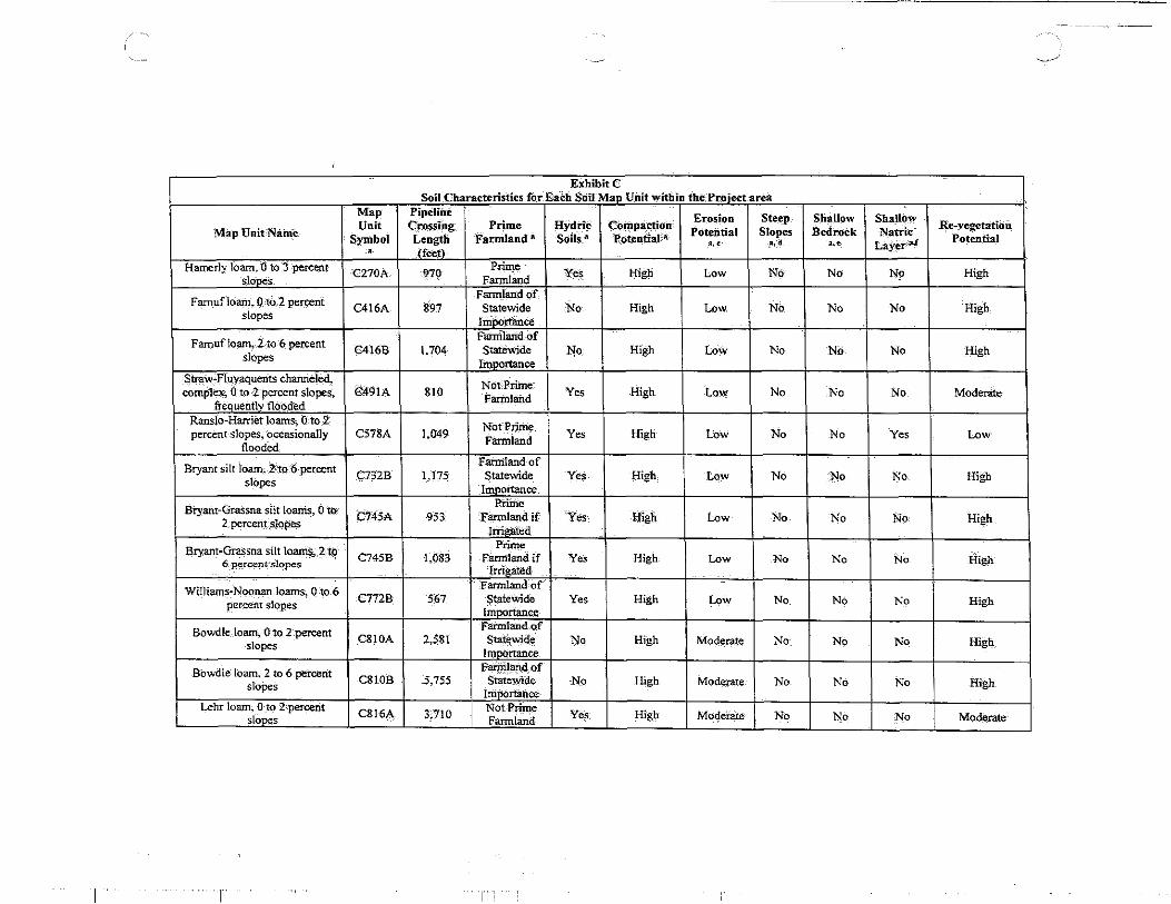
Exhibit C Soil Characteris-tics for EaCh SoifMap Unit within the Project-area
Map Pipeline Erosion Steep ShaiJow Shallow
Map Unit Name Unit Cross-i_ng Prime HYdriC- COtnpa-ctio·n
P"otential Slopes Bedrock Natric R.e-yegetation
Symbol Length Farmland_ a SOils a Potential-a '·' •• d ... La:f_~r-a.r
Potential • (f.;t)·
Hamerly loam, -o to 3 percent C270A 970
P-rim.e Ye~ High Low No- No No High
slooes Farmland
Famufloam, 0-tO 2 percent Fannland of_
C416A 897 Statewide No High Low No No No High slopes
IrilDortance
Famufloam, 1 to 6 percent Farmland. of
C416B 1.704 Statewide No. High Low No No No High slopes Importance
$traw.:.Fiuvaquen·ts channeled, NOt-. Prime
complex, 0 to 2 percent slopes, C491A 810 Farmland Yes High Low No No No Moderate frequent1V "floOded
Ranslo-Harr:iet loams, o·-to 2 Not Prime
percent slopes, o_ccasiona1Iy C578A 1,049 Filrmland Yes High Low No No Yes Low floodi::d
Bryant silt loam_; 2'to 6-percent Familandof
C732B 1,175 Statewide Yes High Low No No No. High slopes Importance
Bi"yailt-Grassna silt loani.s, 0 to Ptiffie
c745A -953 Farmland if Yes High Low No No No· High 2 percent_s_lopes Irrigated
Bryan~·Grassna silt loarnS-, 2-to P'rime
C745B 1,083 Fatmland if Ye·s High Low No No No High 6 percent slopes !rrigated
Williams-Noonan loams, 0 to.6 Farmland of
C772B 567 Statewide Yes High Low No No No High percent slopes !mportance
Bowdle_. loam, Oto 2 :percent Familandof
C810A 2,581 Statewide No High Mod~~e No No No High slopes Importance
Bowdle· loam. 2 to 6 percent Fa$landof C810B 5,75.5 Statewide No High Moderate No No No High slopes
Importance Lehr loam; 0 to 2 percerit
C816A 3,710 Not Prime
y"l' High Modeiate- No No No Moderate slooes Farmland
I 1.,,!

--../
ExhibifC Soil.Characteristics for Each SoitMau Unit within the Proiect area
Map Pipeline Erosion Steep Shallow- Shallow Re-vegetation Unit Crossing Prime Hydric Compaction Potential Slopes Bedrock ~atric Potential Map Unit Name SYmbol Length Farrriland" Soils'• Potential a
~' ~· " Layer as • (f.;.l Lehr loain, 2 to 6-percent CS16B 6,:ll! Not Prime Yes Hi&h Mod-erate Np No No Moder~te
- slooes farmland Vida vel)' stony loam, 3 to 15 C819B 8,786
Not Prime Yes High Moderate No' No No Moderate
.Oercent slones Farmland Wabek.,.Lehr-Appam complex,.
C870E 203 Not Prime Yes High High Yes No No Low
9 to 25 oercent slooes Farmland Wlibek-Appam complex,.6 to 9
C874C 563 Not Prime Yes MOderate High No No No Low n.ercent sloDe·s Farmland
Wabek-Lehr cotnpJex, 6 to 9 C877C 1,993
Not Prime Yes Moderate High No No No Low i
nerCent sione:s Farnilaild Pits. gravel and-sand; 0 to 60
C990F 243 Not Prime No NotRat~;d High Yes No No Low
oercent slopes Farmland
~-~hel:wn--c~unzy • ·><•·"' ': ..
Tonka~Nishon silt loams., 0 to l C004A 228 Not-Prime Yes l:!igh LOw No l'!o No Modeq~.te nercent stones Farmland
Heil silt loam, undrained., Oto 1 C020A 238
Not Prime Yes High Low No No Yes Low nercent slones Fannland
Vallers loam, undrairied, 0 to 1 Prime C022A 112 Farmland'-if Yes High Low No No No Moderate' percent slopes
Drained Nishon-Heil silt Ioams, 0 to 1 C03JA 326 Not-Prime Yes High Low No No No Moderate nercent slones Farmland
Vida~ Williams loams, 3 To 6 Farmland of C136B 1,364 Statewide Yes High Moderate l'!o No No High percent slopes
lmnortance Williams-Bowbells~ Tonka, Farmland-of undrained CQq~.ptex, 0 to 6 C150B 1,730 Statewide Yes High Low No No No High
percent slones lllll>Ortance Vida~ Williams-Bowbells C177D 1,294
Not Prime Yes High Moderate Yes No No Moderate Ioams. 3 to 15 percent-slOpes F3nn!and
Bowbells loam, 3 to 6 percent C201B 987
Prime Yes High Low No No No High sl.;,s . Fannland
--
1"'1"1
"··-' .-../·
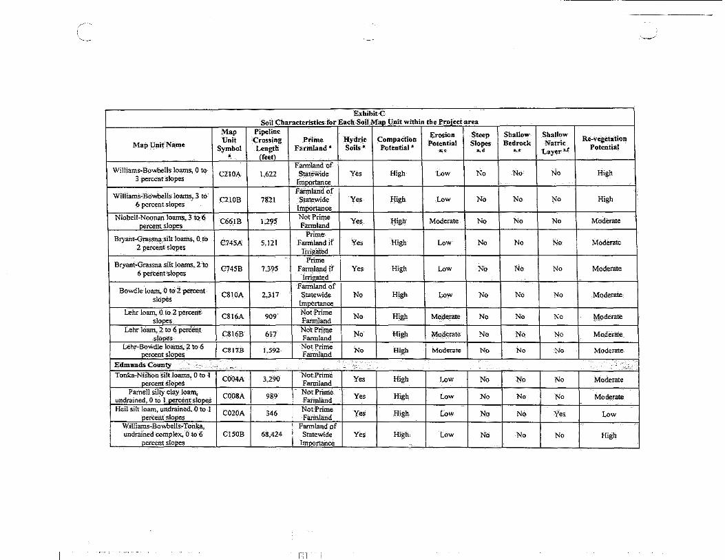
Exhibit C Soil Characteristics for Each Soil Mao Unit within the Project area
Map Pipeline Erosion Steep Shallow Shallow Re-vegetation Unit ·crossing Prime Hydric Compaction Potential Slopes Bedrock Nat ric Map Unit"Na.me Symbol Length Fat:mland .. Soils • Potential a
~· ~· Layera.C Potential ~· • (feetl
Farmland of H;gh Williams-Bowbells loarns, 0 to C2!0A 1.622 Statewide Yes H;gh Low No No No
3 percent Slopes Importplce Faimland of
William5"BOwbe1ls lo~ 3 to C210B 7821 Statewide Yes High Low No No No High 6 percent slopeS Importance
Niobell-Noonan IOant$, 3 ,to~ C66IB 1,295 Not Prime
Y~s H;&i> Moderilte No No No Moderate percent slopes Farmland
Prime Bryant-Gras.snasilt loarris, 0-tO C745A 5.121 Farmland if Yes High Low No No No Moderate
2 percent slopes lrrigoted
Bryant-Grassna silt loams,_2 to Prime C745B 7.395 Farmland if Yes H;gh Low No No No Moderate
6 percent slopes Irrigated
Bowdle-loam. 0 to· 2 percent farmland of
CSIOA 2,317 Statewide No High Low No No No Moderate slopes
bl!j>Ortance Lehr loam. 0 to 2 percent C8!6A 909
Not Prime No H;gh Moderate No No No Moderate slooes Farmland
Lehr loam,2 to 6 percent C816B 617
NOt-Prime No H;gh Moi:Jerate No Nq No MOderate-_ slooes Fannlimd
Lehr-BoWdle loam·~ .2 to 6 C817B 1,592 Not Prime No High Moderate No No No Moderate percent slooeS Farmland
Edmunds County ·.·· . . '> Tonka-Nishon silt loams,- 0 to 1 C004A 3.290
Not. Prime Yes High Low No No No Moderate percent slooes Farmland Parnell silty clay loa.ll\ COOSA 989
Not. Prime Yes High Low No No No Moderate undfained, 0 to t.oeTcentslooeS Farmhurd Heilsilt loam, un:drained,.O to 1
C020A 346 Not'Prime Yes H;gh Low No No Yes. Low percent sloocs Farinland Williams-Bowbells,. Tonka, Farmland of undrained complex, 0 to 6 CISOB 68,424 Statewide Yes High Low NO No No High
percent slooes ImPOrtance
1: I

'~- '----'
Exhibit C Soil CharacteristiCs for Each S-otf':Mao Unit within-the Pro_fect:area
Map fipeline HydriC COJiip3.'di0n
Ei'OsiOn Steep Shallow Shallow Re--vegetation Unit Crossing Prime Potential_ Slopes Bedrock Natri~ Map Unit Nam~ Symbol Length Farmla-nd a Soils-a Potential" ~d ... LayerJAJ Potential •. '
• <rei<> Vida:-Zahl-16artis, 6 to 9 percent Cl75C ~.016
NOt Prime Yes- High Moderate· Yes NO No :Moderate slopes Farmland,
Vida-William~-Bowbetls CI77D 147 NolPrime
Yes High Moderate Yes No No Moderate loams,3 to 15 percent slon~s Familand_
Williams-Bowbells loarns, 3- to Farmland of
No High C210B 76,709 Statewide Y-es High Low No No 6 percent.slopes Importance
Witlia.tns.Bowbells loams.,. 6 to Fannlandof
High C2IOC 4,705 Statewide Yes MOderate MOderate No No No 9 percent.s.lo~ Importance
-Prime Mondamin silty-clay loam, 0 to C420A 5,463 Farmland if YeS Low Low No· No No Modet:?te
2- percent slopes Irrigated
Prime Mondamin silty-clay loam,·2 to
C420B S.)03 Farmland if Yes Low Moderate No No No Moderate 6- percent slopeS Irrigated
Mondarnin-Heil c6rilJ)ll!x,. 0 to Farmland of
C430A IA23 Statewide Yes High Low No ·No NO High 2 percent slo~s. Importance
Grassna_silrlOam, Q '00· 2 C4S7A 174
Prime Yes High Low No No No High percent-slOt:!~ Farmland
Niobell-Noonan loams, 3 to 6 C6~IB 1~3-79
Not Prime Yo. High Moderate No No No Moderate
~ntslooes Farmland
BoWbells-Niobell loams; 0 to-3 Farmland of
C670A 5,584 StateWide Yes High Low No No·· No High percent slopes
Il)l~rtance
Bryant silt loam, 0 to. 2-percent Farmland of
C732A 278 Statewide Yes High Low No No No High slopes
Importance
Bryant silrloam, 2 to '6. percent Fannland of
C732B 6,955 Statewide Yes High Low No No No High slopes Importance
r ITI ::

'------ - ~·
E:<bibitC Soil Characteristics for Each Soil Map._Unit within-the Protect area
Map "Pipeline Erosion Steep Shallow Shallow
Map Unit Name Unit Crossing Prime Hydrit: co-~pa_ctiO-u Potential Slopes Bedrock Natric
Re-vegetation Symbol Length Farmland • Soils-11 Potentiat *
~· ~· ... Layer# Potential • <feetl
T-emvik~Bryant complex., -2· to 6 P-rime
C74IB 1,463 Fannland if Yes Moderate Low No NO No Moderate percent slopes Irrigated
Temvik~Grassna silt loams, 2 Prime
C742B 1,209 farmland if YeS Moderate Low No No No Moderate to 6 percent slopes
Irrigated
Bryant-Grassna silt loam~ 2 to Prime
C745B 2,062 Farmland if Yes High Low No No No Moderate 6 percent slopes
l.....,..,d
Bowdle loam, 2 to 6 percent Farmland of
C810B 138 s·talewide No High Moderate No No No High slopes
Importance
Faulk County ..... ·· . .. : .. :'~. ; ,·
Tonka~Nishon-silt Joams~ 0 to 1 C004A 3,707
Not Prime Yes High Low No No No Moderate percent slopes- Farmland
Parnell Silty clay loam,. COOSA 151
Not Prime Yes High Low No No No Moderate
undrained. 0 to 1 oerceht slooes Fannland Nishon silt loam,() to 1 percent
C030A 2,964 Not Prime Yes liigh Low No No No Moderate slopes Fai:m13nd
Zahl-Williams~Zahill complex, Cl35C 538
Not Prime Yes High Moden;tte No No No Mo!ierate 6.to 9 percent sloneS Farmland
Vida-Williams-Bowbells Fannlandof
loams, 3 to 9 percent slopes Cl38C 3.601 Statewide Yes High. Moderate Yes No No Moderate
rmoortance Zahill~Straw complex,; 2 to-25:
C139E 697 Not Prime Yes High High Yes No No Low -oercent slopes Famlland
Williams-Bowbells·Tonka, Farmland of undrained complex, 0 to 6 C150B 21.122 Statewide Yes High Low No No No High
nercent slooes lmoortance
Max-Arnegard loams., 0 to 3 Prime C167A 666 Farmland if Yes. High Low No No No Modetate percent slopes
Irrigated
I ITI

Map Unit
Map Unit Name Symbol •
Max-Amegaro;.zaht Ioams, '0 to C168B 6 percent slopes
Williams-Zahill-Bowbell$ C!73D
loams. 3 to 15 ~ntslopes-BowbellS 1oam. 0 to: 3 percent C201A
slooes
Williams~BO\vbells lo~,. 0 to C210A
3 percent slopes
Williams-:Sowbelts loa.rns,-'3 to C210B 6 percent slopes
Straw loam. 0 to2 percent C490A slooes St:raw-Fluvaquents channeled. complex, 0 to-2.percent ~lope$. C491A
freauentlv flooded Noonan-M4'anda loam.s,. 0 to 6
C556B uei<:ent slo0¢s Ranslo-Haniet lOam~ 0 to 2 percent slopes, occasionally C578A
flooded Harriet loam, 0 to ~ percent C584A
slooes Niobell-Noonan-Max lo<l!lls, 0 C650A to 3 nercent slooes Niobell-Noonan loams. 0 to 3
· nercent slooes C66IA
Williazns..Niobefl toams. Jto-6 C667B perCent SlopeS
Max-Niobell-Noonan loams, 3 to 6 UerceOt slooe C672B
I
Exhibit C Soil Cbarat:teristics for Each Soil MaP Unit within the Proiect area
Pipeline Crossing Length (f..;;)
13,494
4,654
317
30,402
21,107
1,357
2,050
4,199
1,095
426
4,985
3,790
5,076
8,195
Prime Farmland •
Prime Farmland if
Irrigated Not Prime Fartnland
Prime Farmland
farmland of Statewide
lmoortance Farmland of S~tewide
Importance Prime
Farmland
Not Prime Faimtand
Not Prime Farmland
Not Prime Farmland
Not Prime Farmland Not Prime Farmland Not Prime Farmland
farmland of Statewide
Importance Not Prime Farmland
,,., '
Erosion Steep Hydric Compaction
Potential Slopes Soils"" Potential"
~· ~·
Yes High Low No
Yes High Moderate Yes
Yes High Low No
Yes High Low No
Yes High Low No
Yes High Low NCI'
Yes High Low No
Yes High Low No
Yes High Low No
Yes High Low No
Yes High Low No
Ye-s High Low No
Yes High Low No
Yes High Low No
_____./
Shallow Shallow Re-vegetati'on
Bed nick Natric Potential ... Layera.r
No No Moderate
No No Low
No No High
No No High
No No High
No No High
:No No M0:derate
No Yes Moderate
No Yes Moderate
No Yes Moderate
No No Moderate
No No Moderate
No No High
No No Moderate

Map Unit
Map Unit Name Symbol •
Bryant .. Grassna silt loams~ _0 to C745A 2 percent Slopes
Tally fine· san4y loam, 0 to 2 C769A percent slopes
Tally fine sandy loam,~ to 6 C769B percent slopes
Williams-Bo~lls-Noonan C773A loam~ 0 to3 percent slopes
Bowdle loam, 0 to 2 percent C810A slopes
Lehr loam,. 0 to 2 percent C816A
slooes Lehr loam, 2 to 6 percent
C816B slooes Pits. gravel and-sand, O-to-60
C990F percent slopes
Spink County /
Beadle,-Stickney complex, 0 to BeA
2 percent slopes
Beadle-Stickney comple.'<, 0 to BfA 2 percent slopes. very stony
Tonka-silt loam. undrained, 0 COO!A to 1 nercentslOoes
Tonka~Rimlap silt loams,- 0 to 1 CO lOA oercent slooes Heil silt loam, undrained,_ 0 to 1
C020A oercent slooes
I
~--
Exhibit-C Soil Characteristics for Each Soil M~ Unit within :the Proiect area
Pipeline Crossing Length _(feet)
3,180
2.932
203
2,567
2,814
273
212
540
38~081
2,639
272
477
274-
Prinie Farmland ,a
Prime F-landif
Irrigated Prime
Farmland if Irrigated
Prime Farmland if
Irrigated Farmland of
Statewide 11ll!l0rtance Farmland of
Statewide Imoortance Not Prime F~and
Not-Prime F~and Not-Prime Farmland
Fannlandof Statewide
Importance Not Prime Farmland Not Prime Farmland Not Prirrie F~and Not-Prime Farmland
,., ''
HydriC Soils"
Yes
Yes
Yes
Yes
No
No
No
No:
.•
Ytes
Yes-
Yes
Yes
Yes
Erosion Steep 'Compa_tt_il)n
Potential Slopes Potential • a_,c ~·
High Low No
High Moderate No
High Moderate No
High Low No
Low Low No
Low Low No
High Moderate_ No
Not Rated Low y-es
High Low No
High Low No
High Low No
High Low No
High Low No
Shallow Shallow Re-vegetation
Bedrock Nat ric Potential ... -~ Layera.r
No No Moderate
No No Moderate
No No Moderate
No No High
No No High
No No Modetate
No No Moderate
No No LoW ,_ --
No No High
No No Moderate
No No Moderate
No No Moderate
No Yes Moderate

Exhibit_:C Soil CharacteriStics for Each Soli Map Unit"wiihin the Project area
Map Pipeline Erosion steep SbaJ)ow Sb:iillow Re-vegetation Unif Crossing Prime Hydric Com'pa:ctiOn:
Potential SIC) pes B'edrock Natric Map Unit Name Farmland a SOils 11 POtential"' Potential Symbol Len~h ... ••• ~· Layera.r • (feet
Lov."e loarn,._O to 2 percent C054A 2,460 NotPriine
Yes High Low No No NO Moderate slopes. occasSiOnallv flooded farmland Zahl..zahillloams, 15 to 40
C058A 479 NofPrirD.e
Yes High Low No No No Moderate oerc~tStones Farmland
Zahi~ZahiU e9mplex, 15 "tO 40 C13.3F 164 NOt-Prime
Yes High High Yes No No Low percent s-lopes Farmland
Williams~Niobeii~TOnka Farmland of
l-!igh C147B 6,410 Statewide Yes High Low No No No complex, 0 to 6 _percent slopes
lnroo-ce
Max~Amegard loams, 0 to 3 Prjme
No No Moderate C167A 8,850 Farmland-if Yes High Low No percent s_!_opes
Irrigated Prime
Max~Arnegard-Zahlloam~, o·to C168B 27,5.89 Farrriland if Yes High Low No No No Moderate
6 percent slopes lrricrated
Max~Zaht~Amegard lmmls, 3',to Fannlandof
CI68C 6.97 Statewide Yes High Mo9-erate Yes _No No Moderate 9 percent.Siopes
lmoOrtance Noonan-Mirand3:_loams, 0 to 6
C556B :1,317 Not Prime
Yes High LoW No No Yes Mo!feratc; nercent slooe::t Fartnland Miranda~Heil complex. O'tQ ~
C558A 1,150 Not'Prime
Yes High Low No No Yes Moderate oercent slopes Fannland Ranslo- loain,: 0 .to·2 percent
.C575A 610 Not_Prime
Yes High Low No No No Moderate slooes Farmland Niobeii~NOonM-loarits, 0 to-3
C661A 2,409 NOt Prlrrie
Yes High Low No No No Moderate nercent stones Farmland
Williams~Niobelllt)ams,._ 0 to 3 Farmtand:.of
C667A uoo State"wide Yes, High Low No No No High percent slopeS' Importance
Willtams,.Niobellloams. 3 to 6 Farmland-Of
C667B 498 Statewide Yes High Low No No No High percent slopes ImPOrtance
Niobell·No<>nan-HeiJ complex, C668A 2,647
NOt'Prjme Yes Hig}l !,ow No No No MoP,erate 0 to 3 ·percent slOpes Fannland
I I T I I

-./
Exhibit-C Soil CharacteristiCs for :Each Soil Mau Unit w1tbin the Project area
Map Pipeline Erosion Steep Shallow Shallow Re-vegetation Unit Crossing Prime Hydric Compaction Potential Slopes Bedrock Natric Map Unit Name Symbol Length Farmland' Soils-• Potential • ••• ... Layer a/
Potential M . creetl
CrosSplain-Tetonka complex,. 0 Pri111e
No No No Moderate Ct 6!9 Farmland if Yes_ High Low to 1 percent-slopes D'rained
Prime Moderate Delmont-Enet IoamS, 0 to 2 DeA !.854 Farmland if Yes High Low No No No
percent slopes Irri~ated
Dudley-Jerauld silt loams. O.to Du 3,827 Not-Prime Yes High Low No No No Moderate
2 percentslooes Farmland Ethan-Hand loams, 9 tO 20 EnD 3,203
Not Prime yes High High No No No Moderate percent stones Farmland
Cresbard-Cavour loams, 0 to 3 G!24A !.658
Not·Prime Yes High Low No No No Moderate percent slo;,.,. Farmland
Cavour~Ferney loams, 0 to 3 Gl29A 2.097
NOt Prime Yes High Low No No No Moderate oerCent stones Farmland
Ferney-Hen. till substratum Gl33A 1.017
Not Prime Yes High Low No No Yes Moderate complex, 0 to 3 oercent slooes. Farmland
Forman-Cresbard-Tonka Farmland of Gl36A 219 Statewide Yes High Low No No No High
complex, 0 tO 3 percent slopes lrnportanoe FaimlandOf
Fonnan..Cresbard looms. 0 to 3 GI39A 1,409 Statewide Yes High Low No No No High percent slopes Irrt.,-onance Forman-Buse-Aastad loams, 1
G!90B 5;910. Prime Yes High Low No No No High to 6 percent sloees FWmland
Fonnall"'Buse-Aastad foams, 3 Farmland of
GJ9.0C 704 Statewide Yes High Moderate No No No High to 9 percent slopes Importance Aastad-Fo~ loams, 0 to 3
G!93A 627 Prime Yes High- Low No No No High percent slones Farmland Buse-Vida. m9ist-Fonnan
GI93E 514 Not Prime Yes- High High Yes No No Low loams., 9 to :is' Dereent sloues Farmland
Aastad-Tonka complex, 0 to 3 Prime
G195A 375 Familand-if Yes High Low No No' No Moderate percent slopes Drained
I I I I

Map
Map Unit Name Unit
Symbol . Bearden silt loam, saline, O·to 2 G453A
oercentslooes Aberdeen"'Nahon~Heil :silt
Ioams, till substratUm.,{) to 2 G476A percent slQ'ReS
Lowe lOam, very po~;>rly drairied, 0 to. 1 percent slopes. G5Z2A
frequently flooded Lamoure silty,clay loam,.
somewhat poorly drained, 0 to· G533A
I percent slopes. frequently flooded
Playmoor silty clay Ioam. 0 to 2 percent slopes, frequently G543A
flooded RansJo~Harriet loams. Oto 2 percent slopes, occasionally G553A
flooded RanstO silty clay loam, 0 to 1 percent slop~, occasionally G557A
flooded G~at Bend~Beotia silt looms_, 0. G720A
to 2 percent slOpes Great Bend-Beotia-siltJOarns, till-substratum, 0 to 2 percent G721A
slopes Great Bend-Zell silt learns, 2 to
G722B 6 percent stones
Kranzburg-Cresbard silt lOams, G796A 0 to 2 percent slopeS
Harmony~Beotia-silt loams, till substratum, ·o to 2 percent G863A
slopes
I
Exhibit-C Soil Characteristics for Each Soil Mao Unit within the Proiect area
Pipeline Erosion Steep Crossing Prime Hydric ~tt:mpadion Potential Slopes Length Farniland • Soils• 'Potential 11 .,, ••• <feet)
484 Not Prime Yes Hig)t Low No Farmland
Not Prime 517 Farmland.
Yes High Low No
Not Prime 238
Farmland Yes High Low No
Prime 243 Farmllmd if Yes High Moderate No
Drained
Not Prime 67 Farmland
Yes Hig)t Hig)t No
Not Prime 903
Farmland Yes Hig)t Low No
Not-Prime 605 Farmland YeS <figh Low No
1~509 Prime
Ye' Rlgh Low No Farmland
Prime_ 2,642 Yes 'High Low No Farmland
2;538 Piime
Yes Hig)t Low No Farmland Farmland of
1,657 Statewide Yes High Low No Imoortance
Prime 2,598 Farmland Yes Hig)t Low No
I I i
Shallow Shallow Bedrock Natric
"' Layer•.r
No No
No No
No No
No No
No No
No No
No No
No No
No No
No No
No No_
No No
Re-v~etation
Potential
M09erate
Moderate
Moderate
Moderate
Low
Moderate
Moderate
Hig_h
Hig)t
High
High
Hi~h
' -._../
,,_ ~~
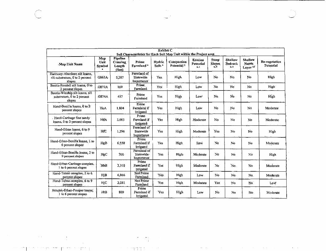
,Exhibit C Soil CharacteristicS for-Each Soil Map Unit within .th'e'Pi"oject area
Map Pipeline EM ion Steep Shallow ShalloW
M~rp,Utiit Name Unit crossing Prim-e Hyd'ric Com'p3.ction
Potential Slope< Bedrock Nattie_ Re-vegetation Symbol Length Farmland',;: SOils"' PoteDtial a
~' .,, a. e.- Layera.f Potential . (f.;tl
Harmony:-AberdeetJ. silt 1Qams. F3.nnland. oJ till substratrn:n,_ a·'·to 2 percent G865A 5~387 Statewide. Yes High Low No No No High
Slopes ImOOrtance Beotia-Rondell silt loam~ O·.ro_ G872A 169
Priine_ YeS_ High Low No No No High 2 percerit·slopes_ Farmland
Beotia-Winshjp.silt lo_arro..s, till Prime
substratum, 0 to 2 percent .G874A 457 Farmland
Yes High Low No N:O No High slopes
Hand~Bonilla loams; 0 toJ .. Prime HcA 1,804 Fafmland if Yes lc1igh Lo.w No No No Moderate
percent·slopes ltTig.,ed
_ Hand-Carthage fine·sandy Prime
HdA 3,003 Farmland if Yes High Moderate No No No Moderate Joams, 0 to 3 p_ercent-slop~;:s lrrieatecl
Hand-Ethan IQ_~ 6 to ~ Fa:rmland of
HfC 1,296 Statewide Yes High Moderate Yes No No High percent slopes Importance
Hand-Ethan-Bonillaloams, l to Priin'e
HgB 6,550 Farrrilandif Yes High t;ow No No No Moderate 6 percent slopes; Irrigated
Hand-Ethan-Bonilla-loams, 2 to Faimlandof
HgC 700 StateWide Yes High Moderate NO No No High 9 -pe_rcent slo-pes Iinp(,rtance
Hand-Ethan-Carthage -complex_. Prime
HhB 2,31& Fafmlandif Yes High Moderate No No No- Moderate 1 to 6 percent slopes Irrigated Hand-Talmo complex, 2 to 6
Hjll 6,866 No( Prime
Yes High Low No No No Moderate percent slopes Fafmland Hand-Talmo.-CQmp_lex, 6 to 9 HjC 2,281 No~ Prime
Yes High Moderate Yes No No LoW oercent slooes Fafmland
Houdek-Ethart-Prosper loamS_. Prime
HtB 809 Farmland if Yes High Low No No No. Moderate 1 to 6 percent slopes Irrigated
I T
', ...... _./
ExbibltC Soil Characteristics for Each-Soil Map Unit-within the PrQi~t area
Map Pipeline-Compacti_on:
Erosion Steep Shallow Shatl(!w Re'-Vegetation Unit Crossing t"r'iJ11e Hy~ric
Potential Slopes- Bedrot::k Natrie MapUnit;Name Symbol Len~h Farmland 11 Soils 11 Potential_.
~· ••• ~· Laye-r ..S Potential . (feet
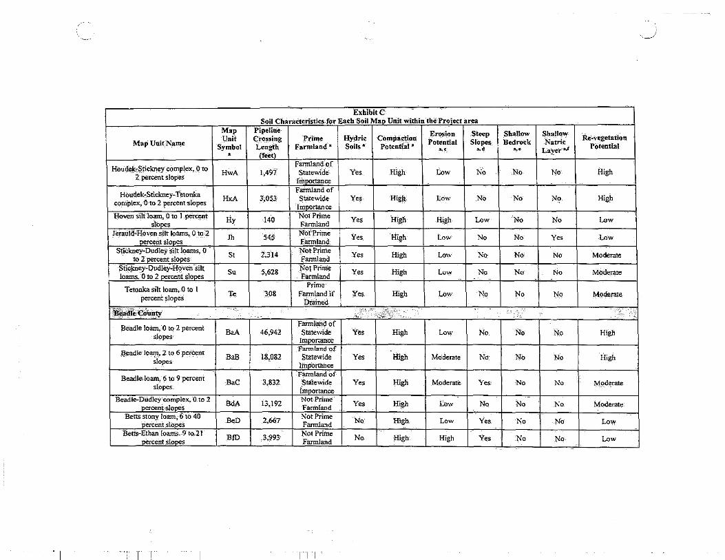
Houd~~S_tickney co_mplex, 0 to Fann1and-oJ
No No No High HwA 1,497 Statewide Yes High Low 2: percent slopes Importance
Houdek-Stickney-Tetonka Farmland of
High HxA 3'~053 Statewide Yes Hig~ tow No No No coniplex, -o to 2 percent slopes Imoortan ce Hoven -silt lo3Il4 0 to 1 percent Hy I40
Not Prime Yes H~gb High Low No No Low slo~s Fannland Jerauld·Hoven.silt loamS;- 0 to-2
Jh 545 NOt-Prime Yes High Low No No Yes Low percent slopes Fannland
StiCkney~ Dudley Silt loams, 0 St 2.3I4
l'ot Prime Yes High Low No No No Moderate to 2 percent slopes Farmland Stickney-Dudley-Hoven silt Su 5,628
Not Prime Yes High Low No No No Moderate loams .. 0 to 2 oercent slopes Farmland
Prime Tetonka silt loam. 0 to I Te 308 Farmland if Ye_s High Low 1-\o No No Moderate
percent slopes Drained
~~eCounty' .. ,? ...• -' ~·_:;:;· •. ' ''.i
Beadle loam,() to 2 percent Farmlan.d of
BaA 46,942 Statewide Yes High Low No No No High slopes· Imoortance Farmland of
Be_adle loam, 2 to 6 percent BaB 18,082 Statewide Yes High Moderate No No No High slopes Imoortailce
Farmland of Beadle-loam, f) to 9 percent
BaC 3,832 Statewide Yes High Moderate Yes· No No Moderate slopes Importance
Beadle-Dudley ·complex, 0. to 2 BdA 13~192 Not Prime
Yes High Low No No No Moderate nercent--slo~ Farinland Betts stony loam, 6 to 40
B~D 2,667 Not. Prime No High Low Yes No No Low oercent_slo_oes Farmland
Betts-Ethan Ioams.9 to'21 BID 3,993 Not Prime No High High Yes No No Low nercent slooes Farmland
I I I I

~
Exhibit,C Soil Characteristics for-EaCh"Soil Map, Unit within the-Pro_iectaru
Map Pipeline Erosion Steep Shallow Shallow
Map Unit Name Unit Crossing Prime Hydric Compaction -potenQal Slopes Bedrock Natri_c
Re:-vegetation Syhlbol Lerigth Fatmla·nd-~ Soils· a POtential .a ,,, ,. ,, Layer•.r Potential
• (feet)
Bon silt loam Bo 1;508 Prime
Yes High Low No No No High Fannland
Boncsift loam, channeled BX 2,995 Not Prime Yes High Low No No No Mo(jerate Farmland
C:arihage fine sandy loam. 2 to Farmland of
CaB 126 StateWide Yes Moderate Moderate No No No High 6 percent slopes Importance
Carthage fine sandy loam, 6·to Fannhmd of
CaC 363 Statewide Yes Moderate Moderate Yes No. No Moderate_ 9 percent slopes Importance
Farmland of ' Carthage-Blendc:m fine ~tly CbA 1,155 Statewide Yes- Moderate Moderate No No No Moderate loams, O.to,2 percent slop;es Importance
Davis loam, 2 to 9 ·percent Farmland of
DaB 2,881 Stat~wide No High Low No No No High slopeS Importance:
Delmont loam. Q, t_o.-2 -"Percent DeA 181 Not Prime
Yes High Low No NO No Moderate slooes Farmland
Dudley-StiCkney. sild93.ttts, 0 DsA 10,617 Not Prime
Yes Hi&h Low No No No Moderate-to 3 percent sloP<s Fannland
Dudley-Tetonka silt1oams DtA 2,5'73 NotPrime Yes High Low No No No MOderate Farmland
Egas silty clay.loam Eg 624 Not:Prime Yes High Low No No No Moderate F3.rmland
Elsmere-loamy fine sand.- Em 1,142 NotP'ririle
Yes Moderate Moderate No No. No Moderate loamy substratum Fannland
Enet lo~ 9to ·-2 percent Farmland of
EnA 3,429 Stat~wide Yes High Low No No No High slopes
Importance Forestburg-Doger loamy fihe:
FrA 996 Not Prime Yes High MOderate No No No Moderate sands. 0 to 3 perc:ent.sl~s Fannland
Houdek-Prosper loams, 0 to 2 Farmland of
percent slopeS GQA 7,025 Statewide Yes High Low No No No High
Importance
""I' I T I I

·-· ~
ExhibitC Soil Characteristics for Each Soil Map Unit within the Project area
Map Pi~line Erosion Steep ShallOW Shallow Map Unit Name
Unit CrosSing Prime Hydric Compaction Potential Slopes Bedrock Natrie
Re-vegetation Symbol Length Farmland .a sons~ Potential .a
'·' ~· ~· Layetd Potential . lfeetl
Bend-Edwin·siltloams, 2 to 6 Farinlimd of
GzB 2,962 Statewide Yes High Low No No ·.No High percent slopes -IinOOrtance
Houdek-Ethan loarp~ 6 to 9 Fannlarid of
HeC 1,801 Statewide Yes High Moderate Yes No No MOderate percent slopes
lnl!lOrtance
Houdek~Prosper loams.. 0 to 2 Farmland of
HoA 8,703 Statewide Yes High Low No No No High percent slopes Importance
Houdek-Prosper loams. 2 to 6 Farmland of
HoB 3,513 Statewide Yes High Low No No No High percent slopf:s lmoortance
Hoven sil~ lo.am Hv 460 Not Prime Yes High Low No No No Moderate Farmland
LaDelle silt loam La ],415 Prime Yes High Low No No No High Fannland
Lane silt loam,. 0 to 2 percent Fannlandof
LnA 3,091 Statewide Yes High Low No No NQ High slopes lm[J<J_rtance
Prosp:er--Davison loanl$, 0 to 3 Fannland :Of
PrA 1,570 Statewide' Yes High Low No No No High percent slopes fm!J()rtance
Shue loamy fine sand Sh 380 Not Prime
Yes Moderate' Moderate No No No Moderate Farmland F3rmlahd 'Of
Spottswood loam Sp 878 Statewide Yes High Low No No No High ImPortance
Tetonka-Hoven silt loams Te 721 Not Prime Yes High Low No No No Moderate Farffiiand Edwin silt loam, 6 to I 2 ZeC 529 Not Prime No High High Yes No No Low percent slooes Farmland
-KingSbury County . ~J :: : ·. > ' -- -
. c£5i:
I I i

/
Exhibif·C SoitCharacterisdcs for Eaeh Soil Map·-finit within the Proiec't area
Map Pipeline Erosion Steep Shallow Shallow Map Un~t Name
Unit Crossing Prime Hydric COmpaction Poteritial Slopes Bedrock Natric Re-vegetation
symbol Length' Earmlainf a S~ils"' Potential -• ~· ~· ~· Layer aS
Potential • (feet)
Beadle. loam, 2 tO 6. percent Prime
BdB 692 Familand if Yes High Mode!Jlte No No No Mo9erate slopes Irrigated
Beadle·Dudley C()mplex,. 0 to 2 BeA 1,629
Not P-rime Yes ,Hjgh Low No No No Moderate
percent slopes Farm-land
Bon loam Bn 991 Prime
Yes High LOw Nq No No High Fannland
Bon loam. channeled Bo 1,229 NOt Prime
Yes High Low No No No Moderate Fannland
Clamo-Bonilla Ioams., 0 to 2 Prime
CbA 19,702 Fannland if Yes High Low No No No Moderate percent sl9pes Irrigated
Clamo--Ethan-Bonilla lpams, 1 Prime
CeB 19,012 Farmland if Yes High Low No No No Moderate to 6 percent slope's
Irrigated
Clamo-Ethan-Bonilla loams, 2 Fannlandof CeC 385 Statewide Yes High Moderate Yes No No Moderate to 9 percent slopes
lmoortance Prime
Crossplain-Tetonka complex Ct 5,894 Farmland if Yes High Low Ncf No No Moderate Drained
Delmont-Talmo loams, 2 to 6 DtB 605 Not Prime Yes High Moderate No No No Moderate
peu:ent slopes Farmland Ethan-Bon. channeled, loams, 0
EoD 2,540 Not Prime No High High Yes No No Low to 2~cent slooes Farmland
Ethan-CI~o loams~ 9''{o 15 EtD 1,376 NOtPriine
No High High Yes No No Low percent slopes Fannland
Houdek-Prosper Ioams,. 1 to-{) Prime HpB 1,373 Farmland if Yes High Low No No No Moderate percent slopes
Irri~ated
HOudek-Stickney complex., 0 to Farmland of
2 percent slopes HsA 28;613 Statewide Yes High Low No No No High
--· -- -- - - - - Importance
I I
/"
'
Map Unit Name
Houdek~Stickney complex) 2 to 6 percent slopes
Houdek~Stickney-T etonk.a complex
Stickney-Dudley Silt learns
Stickney-Dudley-Hoven,silt loams
~erCounty
Arlo clay loam
Baltic silty clay loam
B~m silt loam
Clarno-B'onilla loams, 0 to 3 percent slopes
Cfarno~Bonilla loams. I to 6 percent slopes-
Clamo-Crossplain loams; 0 to 2 percent Slopes
Clarno-Ethan <.:Omplex, 2 to 6 percent slo~s
Clamo-Stickney-Tetonka complex, 0 to 2 percent slopes ...
I I
Map Unit
Symbol •
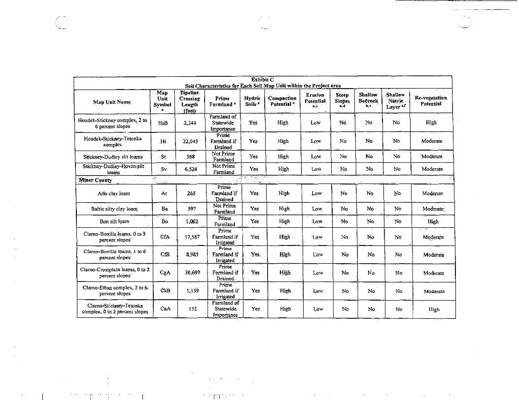
HsB
Ht
St
Sv
,
AI
Ba
Bo
CfA
CfB
CgA
CkB
CnA
ExhibitC Soil-Characteristics for-Eacb'SOU Map Unit-within the Pr.Qject area
Pipeline Erosion Steep Crossing Prime Hydric Compaction Potential $lop<S Length Farmland" Soils a Potenti::i.J.II a,-.;
~· (f.eil Farmland of
2,344 Statewide lmDortance
Yes High Low ~··
Prime-22,045 Farmland if YE:s High Low ~0
Drained
368 Nqt Prime Yes High Low No Farmland
6,524 Not Priine Yes High Low No Farmland /•
Prime 265 Farmland if Yes High Low No
Drained
597 Not Prime Yes High Low No Fanri.land
1,002 Prime Yes High Low No Fannland Prime
17,587 FMmlarid if Yes High LOW No Irrigated
Prime 8,985 Farmland if Yes High LOw No
Irrigated Prime
30,699 Farmlimd if Yes High Low No Drained
Prime 1,159 Farmland if Yes High Low No
Irrigated Farmland of
152 Statewide Yes High LOw No ImportanCe
T I I
, ___ __,
Shallow Shallow Bedi"ock Natric
Re-vegetation
~· Layer2J Potential
~0 ~· High
~. No Moderate
No No Moderate
No No Moderate
No No Moderate_
~0 No Moderate
No No Higll
No No Moderate
No No Moderate
No No Moderate
No No Moderate.
No No High

, __ -~--"
ExhibitC Soil Gharacte·ristics for Each Soii-M3p Unit within tbe Project area
Map Pipeline Erosion Steep ShallOw Shallow Map UnitNa._me Unit CrOsSing Prime HydriC Compaction
Potential Slopes B_ed.rock Natric Re-vegetatiOn
Symbol Length Farmland"' SoilS a Potential -a· .,, •• a,_e Laye·r a.r Poten·.tial . (f.;t) Prime
Crossplain-Tetonka cqmple;.:: Ct 10,595 Fannland if Yes High l..ow No No No Mo.derate Drained
'
Enet-Delmont lO'amS, ·O to 4 Prim~
I EdA 2.439 Farmland if Yes High Low No No No Moderate
percents! opes Irrigated
Ethan-Clarno complex, 6 to 9 Farmland of
EgC 331 State),Vide Yes High Moderate Yes No No Moderate percent slopes lmoortance
Clamo:-Stickney-Tetonka Prim:e La 411 FarmJartd if Yes· High Low No No No Moderate cpmplex, ·o to 2. percent ·slopes Drained
Prime Tetonka silt-1oam Te 504 Farmland if Yes High Lo\v No No No Moderate
Drained
Lal<e,Co.mty ·· .. ·. ····•· . ··:;~.·· .. ,.·., .... ' .·.
Prime Badus silty Claj loam Ba 974 f'armland if Yes High Low No No No Moderate
Drained Cliuno-Ei:han loams, -9 to 16
Be 346 NOt'Piime Yes High Low No No No Moderate percerit sloues· Fannlimd Beadle-Dudley compteX. 0 to 2
BdA 144 Not-Prime Yes High Low No No No Mod_erate . percentsloP,s Farmland
Clarno loam,- 0 to 2 percent CaA 778 Prime Yes High Low No No No High slooes Fannland
Clarno loam, 2 to 6 percent CaB 6;891 Prime Yes High Low No No No High slopes Farmland
Clarno loam, 6 to 9 percent Fannland of
CaC 1,817 Statewide 'Yes High· Moderate No No No High slopes ID:ioortance
Clarno-Ethan-loams, 2-to 6 CeB 649 Prime Yes_ High Low No NQ No High percent slopes Familand
- - -
I I I

. -./
ExhibitC Soil Characteristics for-Bath SOil Map Unit within theProied area
Map Pipeline Erosion Steep Shallow Shallow Re-vegetation Unit Crossing Prime Hydri< <;:ompaction
Pottntial Slopes Bedrock Nattie Map Unit Name Soils a Potential• Potential SymbOl Length Farmland • ~· ~· ~· Layer aS • (f.;t)
Farmland-of MOdefat~ Clarno~ Ethan loams, 6 to 9.
Co<; 7.462 Statewide Yes High Mode~te Yes No No percent slopes
lm~ce
Clarno-Ethan !Qalns, 9!0 16 CeD 3.138 ' Not Prim~::: Yes
-percent stones Farmland High Moderate Yes NO No Low
Farmland of Moderate Egan Silty clay loam, 6 to 9 EaC 3.206 Statewide Yes High Mod~te Yes No No
percent slopes Importance Egan.:Beadle complex.,_ Q to 2
EbA 969 Prime
Yes High Low No No No High ..2_ercent slones Farmland
Egan-Beadle complex,. '2 to 6 EbB 10,790
Prime Yes High Low No No No High
~cent slOpes Fannland Fannlandof
Egan-Beadle cOmplex,. 6 to 9 EbC :3,995 Statewide Yes High Moderate Yes No No -Moderate
percent slopes lmp<>rtance
Egan-Ethan complex,. 2 to 6 Eeb 1.985
Prime Yes High Low No No No High
jl_ercent slopes Farmland Egan·Ethan complel4 6-to-9
EeC2 4,220 ~otPrime
Yes High Moderate Yes No No Low - percent slopes, eroded farmland Egan-Viborg-silty·claylOams,.Q
EgA 1,306 Prime
Yes High Low No No No High to 3' percent slOoes Fannland
Egan-Wectworth~silty clay EhB 13.,.703
Prime Ye' High Low l;o No No High
Ioams. 2 to 6 rcent sJooes Fannland Ethan-Betts loams, 21 to 40. Eof 249
Not-Prime No High High Yes No No Low percent slo-res Fannland
Ethan-Clarno loams, 1.6 t9 21 ErE 652 Not fritlle No High High Yes No No Low percent slorX:s Farmland Ethan-Davis stony corriplex, 3 EsE 3,708
No'tPrime Yes High Low Yes No No Low to,21 pereent slooes Fannland
Ethan-Davis stony complex,.-3 EtD 1.033
Not Prime Yes High Low Yes No No Low to 21 percent slooes Farmland
Houdek-Prosper Joams, 0 to 3 HpA 2.050 Prime Yes High Low No No No High percent-slooes Farmlari'd·
T r
'··-'
ExhibitC Soil Characteristics for Each Soil Map Unit Within the Pro.iect area
Map Pipeline Erosion Steep Shallow Shallow
Map Unit Name Unit Crossing. Prime Hydric CompactiOn
Potential Slopes, Bedrock Natric Re-"egetation
Symbol Length F:llnitland a SoilS ·a Potential• ~· ~· ~· Layer2.f Potential
• rfeetl Prime
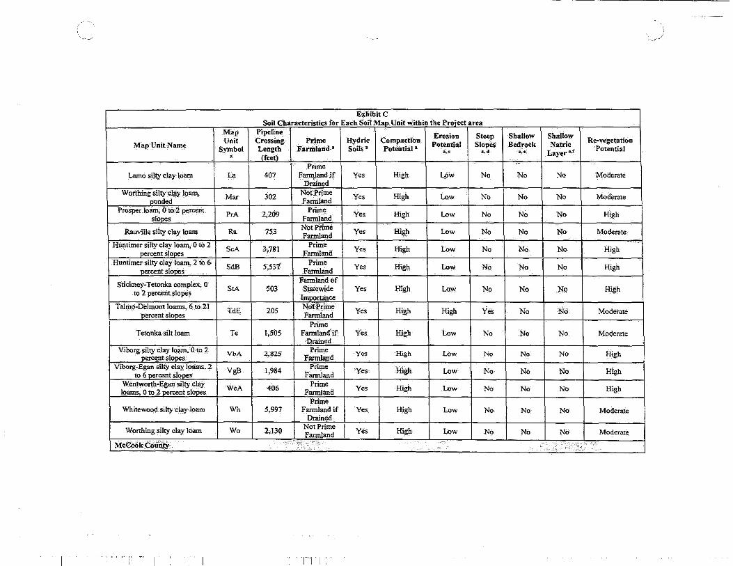
Lamo silty clay· loam La 407 Fannland if Yes Hig~ LOW No No No Moderate Drained
Worthing .silty clay loam, Mar 302
Not·Prime Yes High Low No No No Moderate -oonded Farmland ProSper Jo~ 0 to .. :2 percerit PeA 2,209
Prime Yes Hizb Low No No No High slooes Fannland
Rauville silty clay loam Ra 753 Not:Prime Yes a· h Low No No No Moderate Fannland ~
Htintimer silty clay Ioal11, 0 to 2 SeA 3i781 Prime Yes High Low No No No High
oercent slooes Fannland Huntimer silty clay loam, 2 to 6 SdB 5~537
Prime Yes High Low No No No High -percent slopes Fannland
StickneyMTetonka complex; 0 Fannlandof
StA 503 Statewide Yes High Low No No No High to 2 percent slopes lmoortance
Talmo-Delmont loams, 6 to.2l TdE 205 Not Prime Yes High High Ye·s No No Moderate percent slopes Fannland
Prime Tetonka siit loam Te 1,505 Farmtand"if Yes High Low No No No Moderate
Drilined Viborg silty clay loam,'O to 2 VbA 2,82S:
Priine Yes High Low No No No High percent, slopes Fann!and
Viborg7Egan silty clay Ioams,.2 VgB 1,984 Prime 'Yes High Low No No No High to 6 percent slopes i'armland
Wentwo®~Egan silty clay WeA 406 Prime Yes High Low No No No High loams, 0 to 2 oercent slopes Fannland Prime
Whitewood silty clay loam Wh 5,997 Farmland if Yes High Low No No No Moderate: Drained
Worthing silty clay lOam Wo 2,!30 Not Prime Yes Farmland High Low No No No Moderate
M:cCook_C<>.ili!Y > <:,, '' "' ,> ,,',' ,' ::,, :'
T I
'
T i I

. -o_/)
EXhibitC Soil CharaCteristics for Eiicb Soil Man-Unit within the Proiect area
Map Pipeline ·compaCtioll
Erosion Steep Shallow Shallow Re-vegetation Unit C~ing Prime Hydric
Potential Slopes Bedrock Natric Map Unit Name Symbol Length Farmland a Soils 2 Potentiaf 3
~· ... Layer·a.r Potential "' . (feet\
Egan-Ethan-complex, :5 to--9 Farmland of
High EaC 2,041 Statewide Yes High Moderate No No NQ percent slopes
lmoortance Huntimer silty clay-loam, 0 to 2
560 Prime Yes High Low No No No High
nercent siooes HuA Farmland Wentworth silty day loam; 0 to
1,081 Prime Yes High Low No No No High
2 nercent slones WaA
Farmland Wentworth silty clay lo~ 2- to WhB 1,067
l?ririle Yes High Low No No No High 5 oercent slones Fariiiland
Wentworth-Ethan complex, 2 WeB 1,19Q Prime Yes High Low No No No High
tO -s oercent slopes Fannland Prime
Whitewood silt loam Wh 393 Fannhind if Yes High Low No No No Moderate Drained
Worthing silty Clay loam Wo 2,746 Not Prime Yes High Low No No No Moderate Fannland
Minnehaha County ··.·· •·
.,;,.; ... ··. . ••
Alcestersiltv clay loam. -2· to 6 AcB 400 Prune No High Low No No No High ne~nt slooes Farmland.
Baltic silty clay loam, O.to -1 Ba 1.191 Not Prime
Y-es High Low No No No Moderate ne~cem slooes f.armland Betts-Ethan loams. 15 to 40 BeE 140
Not Prime Yes High High Yes No No Low
oercent slboes farmland
Chancellor silty clay lOam; 0 to Prime
Cb 621 Farmland if Yes High Low No No No Moderate 1 percent.slopes Oralned
Chancellor-Tetonirn complex. 0 Prime
Cc 6.775 Fanriland if Yes Jiigh Low· No No No Moderate to· 1 percent slopes Drained Pi"hile
Davison-.Crossplain clay loatllS; Dd 4,335 Farmland if Yes High Low No No No· Moderate 0 to 2 percent slopes
Drained Egan-Ethan· cOmpleX; 2 to 6-
EaB 1.400 Prime Yes High Low No No No High percent slopes Farmland
I T I I

Exliibit C Soil Characteristics for Ea_ch SOil Map Unit within the-Project·area
Map Pipeline Erosion Steep Shallow Shallow Re-vegetation unit Crossing Prime: Hydric Compaction
Potential Slopes Bedrock Natrit: Pote'ntial Map Unit Name Symbol Length Farm~nd'" Soils a Potential•
'·' ,, ... Layer a.! • (feet) Egan:-Ethah-Trent compl __ ~x,_ 1 EeB 52,056
Prime Yes High Low No No No; High
to 6 oercent slooes Farmland Egan-Trent :Silty clay loams~ 0 EfA 1.243
Prime Yes High Low No No NO. High to 2 nercent slOres Farmland
Egan-Wentworth-Trent silty 9,562
Prime Yes High Low No Np_ No High clay loams, I to 6 percent EgB Farmland
slooes Ethan-Berts loams, 9 to 15 EpD 688
Not Prime Yes High High Yes No No Low
1>ercent slo1>0s Fannland Ethan'ClatJ10 loams, 6 to 25
EsE 1,302 NotP;:time
Yes High Low Yes No No Low Qercent s1ooes, VerY stonV Farmland
Ethan-ClarnO loams, 9to 15 EtD 7,427
'Not Prime Yes High High Yes No No Low
oercent slo""' :i3armland
Ethan--Egan compte~.-6 to 9 Farmland Of
Moderate EuC 25,140 Statewide Yes High Moderate Yes- No No percent slo~s
Imoortance Ethan,. very stony~Egan
ExC 9)5 Not Prime
Yes High High Yes· No No Low complex. 2 to 9 oercent slooes Farmland Huntimer silty clay loam, 0 to 2
HuA 5,483 Prime
YeS High Low No No No High nercent siones Farmland Huntimer silty clay lo~ 2··t:o.Ji:· HuB 2,57§ Prime:
Yes High Low No No No High nercent slooes Farmland
Lamo silty clay loam, 0 to 1 Prime
La 174 Familandif Yes High Low No No No Mod~rate percent slQpes Drained Obert silty clay loam, 0 to I
Ob 350 Not Prime
Yes High Low No No No Moderate .,.;.,ent slooes Farmland Salmo silty clay loam, 0 to I
Sa 1;13_9 ~otPrime Yes High Low No No No Moderate neicent slooes Farmland
Tetonka silt loam, 0 to 1 Prime
Te 209 Farmland if Yes High Low No No No Moderate percent--slopes Drained
r 1 · T I I
·---.-/ f:'
ExhibitC Soil Characteristics for Eaeh Soil Map Unii: within tbe Proiect area
Map Pipeline' ¢pmpaction
Erosion Steep $haJiow Shallow Re-vegetation Unit Crossing Prime Hydric
Potential Slopes Bedrock Natrit Map Unit Name SymbOl Length Farmland • Soilslil Potentia1 4
'·' ~· ... Layeral Potential
• (feet)
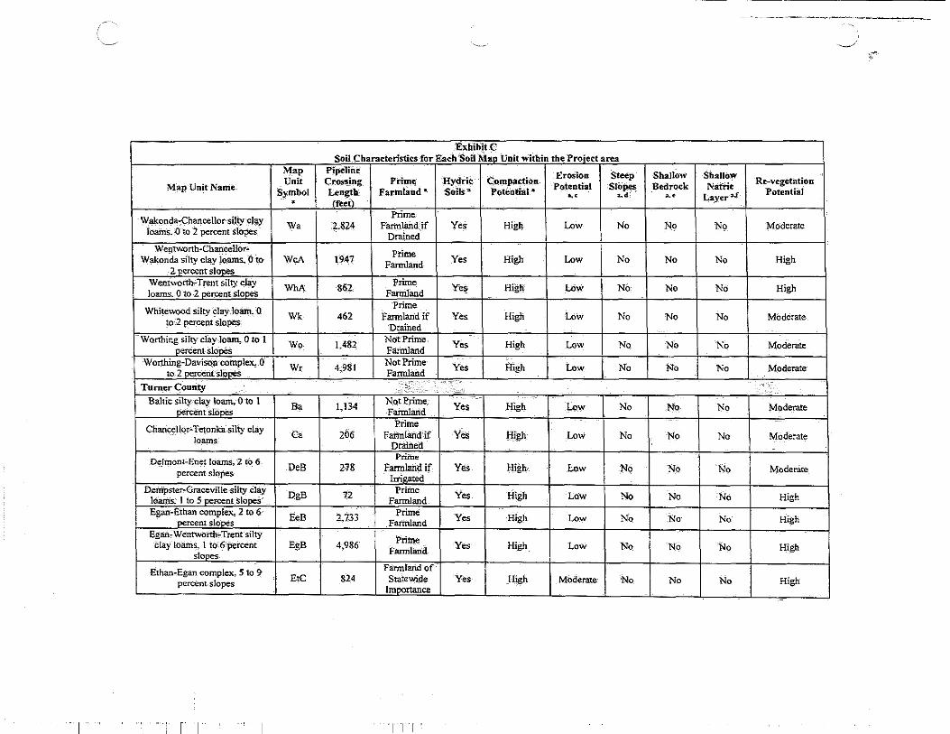
Walco.nda-Chancellor·silty .cJay Prime
Wa 2.824 Fartnlarid_ if Yes High Low No No No Moderate ioams.-{) to i percent Slopes
Drained Wentworth-ChancellOr-
Priine Yes High Low No No No High Wakl)nda silty clay loams., ()to WcA 1947 Familand 2 nercent stones
Wentworth-Trent silty clay WhA 862 Prime Yes High Low No No No High loams. Q to 2 nercenutooes Farmland Prime
Whitewood silty day Joatn~ 0 Wk 462 Fartnland-if Yes High Low No No No Moderate
to: 2 percent sloJ)e;S Dr.ained Worthing silty clay loam, 0 to 1 Wo 1,482 Not Prime Yes High Low No No No Moderate O.rcent slooes Familand Worthing-Davison complex, .0
Wr 4,981 Not Prime -Yes High !.ow No No No Moderate to.i oercent slooeS Familand
Turner ~ounty ,.,, .· .. ··· .... •· ······ Baltic silty clay loam, 0 to 1
Ba 1,134 Not Prime_ Yes High Low No No No Moderate percent slooes Farmlarid
Chan'ceHor.;.Tetpnka silty clay Prime Ca 206 F atml3.nd, if Yes Jiigh Low No No No Moderate loams
Drained Prime Deltnont-Enet Ioams, 2 tO 6
DeB 278 Farmland if Yes High Low No No No Modenite percent slopes Irrieated
Dem'pster-Graceville silty clay J:)gB 72 Prime Yes High Low No No No High loams; 1 to 5 per-cent slopes Familand
Egan-Ethan complex, 2 to 6 EeB 2,733
Prime Yes High Low No No No High nercent slones Fartnland Egan-W ent\.vorth .. Trent ·silty
Prime _ Yes High Low No No No High C!ay'loams. 1 to:6-percent EgB 4,986 slopes Farmland
Ethan-Egan complex, 5 to 9 Fa:nnland of EtC 824 Statewide Yes High Moderate No No No High percent-slopes lmoortance
I I Tll

·, __ . ~
ExhibitC SoilCharaeterisficS for Each. SOH Map Unit-within the P.roj~t area
Ma·p Pipeline Eros:io~ Steep Shallow Shallow
Map-Unit.Name Uliii Crossing P.i"iine. Hydric Coin paction_ Potential Slopes 8-edr:ock Natric Re-v~etation
-Symbol Length Fa_rmland)' Soits·a Poten'tial a ... •• • • ·La)'eri$ Potential • (f.;t)
Huntimer Silty clay:Joam, O_·to 2 HuA 923 PHine Yes High Low No No No High
percent slOpes Farmland Prime
Tetonka silt lOam Te 489 Farmland if No High Low No No No Moderate D'i·ained
Li~ln'£::0imtY ····' ·""' ' . ... " . ·. Alcester silty clay loam, 0 to2
AcA 262 Prime.
Yes High Low No No NO High percenfSIOpes Farmland
Bon soils, frequently flooded Bo 849 Not P-rime No High Low No No No Moderate Fatmland
Chancellor.:.Tetonka silty clay Prime·
ca 12,119 Farmland- if Yes High Low No No No Moderate loams Drained
Chancellor-Viborg-silty clay. Prime
Cd 10,857 Farniland if Yes High Low No No No Moderare loams Drained
Chancellor-Wakonda-Tetonka Farmland, Of
complex Ch 1,141 Statewide Yes High Low No No No High
lmoortance
Davis: loam Da 868 Prime
Yes Farmland
High Low Ni:> No No High
Delmont loam, 2 to 6, percent 'Prime
DeB 1,108 Farmland if Yes High Low No No No Moderate slopes 1trigared D'elmont and' Talmo- soils-, 2' to
DkB 585 Not Prime Yes High Low No No No 9 percentslopes Farmland Moderate
Egan·_siltyclay loam, 3 to- 6 EaB 11,345 Prime Yes High ~w N9 No No High . percent sl2pe:s Fannland
Egan-chancellor sBty f_lay Farniland of EcB 4,50~ StateWide Yes High Low No No No High lo~ 0 to· 4--percent slopes ImportanCe
Egan-Shindler complex, ·z- to 6 EsB 9,013 Prime
Yt:s High Low No No ____ percent s!Qpes Farmland No High
I .I ' r 1· I I

---
Exhibi.tC Soil Char-acteristics for Each Soil Map Unit within the Pro.iect area
Map Pipeline Erosion Steep Shallow Shallow Map Unit Name
Unit Crossing Prime Hydric Compaction Potential Slopes Bedrot:k Natric Re-vegetation Symbol Length Farmland" Soils'" Potentia! • .. ~' ~· Layer a,f
Potential • (fed)
a As designated by the Natural Resources Conservation Service. b Represents total length (in feet) crossed by the pipeline facilities. ~Erosion Potential- Based on land capability class and subclass: High (subclass Ve-VIIIe), Moderate (subclass IIle-IVe). and Low (remaining subclasses)_ d Steep Slopes- Represents soils with slopes greater than 8 percent. e Shallow bedrock - Represents soils with unconsolidated rock 60 inches or less from the surface. e Shallow Natric layers- Represents subsoil layers with a l_arg~ accumulation of sodium salts that can reduce pJant grov.1h within 18 inches or less from the surface_
.I I r 1· T. I!
)
Waterbodies Crossed by the Project

,~'
ExhibitC Waterbodies Crossed bv_the Dakota Ac'eeSS -Pro_iect
Approximate Flow Regime State Classification S U D . . I Crosses Waterbody Name upports se estgnatton c t r Mileoost:l' enji
catt~pb<H;e>incy ;!;:,:;; ' ,' L 21M Unnamed Tributary ofLa.ke Pocasse Ephemeral - - Yes 1
211.0 Unnamed Tributary ofLake,Pocasse Ephemeral - - Yes
211.7 On1_1amed Tributary of'Spring Creek Ephemeral - - Yes
212,6 Unnamed Tributary-ofSpring Creek Ephemeral - - Yes
212.8 Unnamed TributaryofSpring Creek Ephemeral - - Yes
212.9 Unnamed Tributary ofSprrog Creek Iiltemiittenf - - Yes
213.6 UnnamedTributary of Spring Creek Ephemeral - - Yes
214.0 Agricultural Irrigation Ditch Ephemeral - - Yes
214.3 Unriamed Pond Open water - - No
215.0 Unnamed Tributary ofUnnamed Pond Ephemeral - - Yes
215.8 Unnamed Tributary ofUnnanied Pond Ephemeral - - Yes
216.1 Unnamed Tributary of Unnamed Pond Ephemeral - - Yes
216.1 Unnamed Pond Open water - - No
216.7 Agricultural Irrigation Ditch Ephemeral - - Yes
216.8 L!nnamed Tributary o(SpriugCreek Ephemeral - - Yes
217.6 Ui"L.-lamed Tributary ofSpriiig Creek Ephemeral - - Yes
218.4 Agricultural -Irrigation Ditch Ephemeral - - Yes
218.5 Agricultural Irrigation Ditch Ephemeral - - Yes
219.0 Spring Creek P~ial - - • Yes
219.5 Agricultural Irrigation Ditch Ephemeral - - Yes
219.8 Agricultural Irrigation Ditch Ephemeral - - Yes
222.0 Unnamed Pond Open water - - Yes
222.2 Unnamed Tributary ofMc<;Iarem Lake Eph~eral - - Yes
223.7 Unnamed Tributary ofUrinained Pond Ephemeral - - Yes
22_4.7 Agricultura:J Irrigation Ditch Ephemeral - - Yes --
i I' i ; I

/
i ',-·"
'-...-.. /
ExhibitC Waterbodies Crossed b_ythe DakOta Access PrQj~d
Approximate Waterbody Name Flow Regime State Classification Supports Use Designation Crosses MilePost"' Centerline
226.1 Agricultural Irrigat-ion Ditch Ephemeral - - Yes
228.4 AgricultUral Irrigation Ditch Ephemeral - - Yes
229.8 Agricultural Irrigation Ditch Ephemeral - - Yes
232.7 Agricultural Irrigation Dit-ch Ephemeral - - Yes
234.1 Agricultural 'Irrigation Ditch Ephemeral - - Yes
238.8 Unnamed Tributary of Unnamed Pond Ephemeral - - Yes
M\¥b~n C-ounty ·. :;'<-·.: ... · . i 243'.5 Agricultural Irrigation Ditch Ephemeral I - I - I Yes .
E:Qfl:lunds County .··' . ?t_ . . .· ..
247.1 Unnamed Pond Open water - - No
251.4 Unnamed-Tributary of Unnamed P:ond Ephemeral - - Yes
254.3 Agrictiltural Irrigation Ditch EPhemeral - - Yes
255.4 Unnamed Tributary of Unnamed Pond Ephemeral - - Yes
257.6 Unnamed-Tributary of Unnamed Pond Ephemeral - - Yes-
257.9 Agricultural Irrigation Ditch Ephemeral - - Yes
267.9 Unnamed Tributary ofUnnamei:i Pond Ephemeral - - Yes
276.1 Unnilmed Tributary of Stafford Dani Ephemeral - - Yes
277.7 Agricultural Irrigation Ditt;:h Ephemeral - - Yes
280.6 Unnamed Tributary ofNorth Fork Snake_-Cieek Ephemeral - - Yes
281:5 Unnamed Tributary ofNorth Fork Snake- Creek Ephemeral - - Yes
~'Sulk County · .. ·c. [•:• t, . ;;;;':'Z'l '_: •..... ··."\ ;
283.5 Unnamed Tributary _ofNorth Fork Sna.Jce-Creek Intermittent - - Yes . 287.3 Uhnamed Tributary ofNorth Fork Snake Creek Ephemetal - - Yes 288.9 Uimamed Tributary ofNorth Fork Snake C~ek Intetri:littent - - Yes 291.0 Unnamed Tributary o(Nonh Fork Snake Creek Intermittent - - Yes 2923 Unnamed Tributary of North Fork Snake_ Creek Ephe~~ral - - Yes ---------- -
i I I I
Approximate MilePOSe
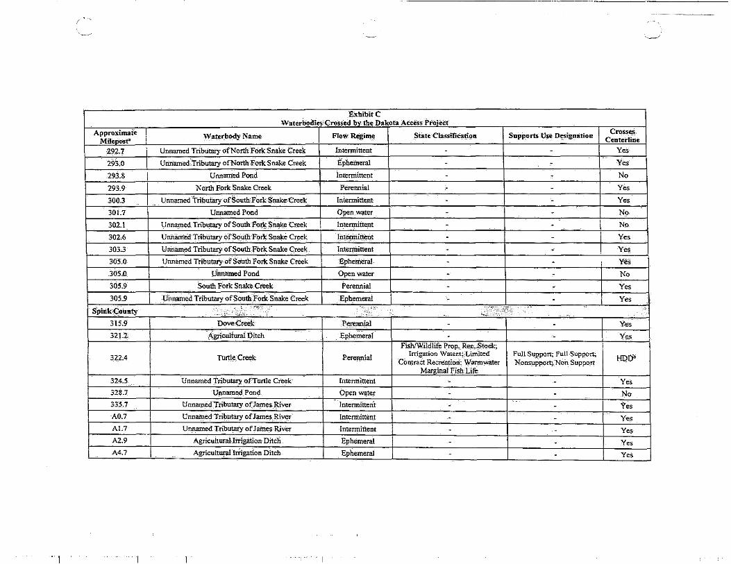
292.7
293.0
293.8
293.9
300.3
301.7
302.1
302.6
3033
305.0
305.0
305.9
305.9
SJ?inkQO~nty 315.9
3212
322.4
324.5
328.7
335.7
A0.7
Al.7
A2.9
A4.7
ExhibitC Waterbodies-CroSsed by tht;.Q:akota Access Pro:iect
\Vaterbody Name FlowRegim~ State ClassifiCa~on
Unnamed Tributary ofNorth·Fork Snake Creek Intermittent
Unnamed-.Tributary ofNonb-Fork Snake Creek Ephemeral
Unnamed Pond Intermittent
North Fork Snake Creek Perennial
Unnamed -Tributary· ofSoutlLFork Snake Creek Intermittent
Unnamed Pond Open water
Unnamed Tributary ofSouthForJs:~nake Creek Intermittent
Unnamed ·Tributary OfSouth-Fork Snake C~ek lhtemiitterit
Unnamed· Tributary of South Fork Snake Creek Tntennittent
Unnamed Tributary of South Fork Snake Creek Ephemeral
Unnamed Pond Open water
·south Fork Snake Creek Perennial
Unnamed Tri!,utary ofSouth.J"otk Snake Creek Ephemeral
Dove Creek Perennial
A,gricultural Ditch ephemeral -Fish/Wildlife Prop~ R~c.Stock;
Irrigation Waters;- Limited COn:traCt Recreation; Wannwater
Turtle Creek Perennial
Marginal Fish_Life Unnamed Tributary ofTurtle Creek Intennittent -
Unnamed Pond Open water -Unnamed Tributary ofJam~s River Intermittent -Unnamed Tributary of Jam~ River Intermittent -Uimamed Tributaiy of James River Intermittent -
Agricultural Irrigation Ditch Ephemeral -Agricultural Irrigation Ditch Ephemeral -
Supports Use Designation
- I
Full Suppon; Full Support; 1 Nonsupport; Non Support
-' -' -' -. -
' --
Crosses Centerline
Yes
Yes
No
Yes
Yes
No
No
Yes
Yes Ye·s
No
Yes
Yes
Yes --Y<;>.
HDD'
Yes
No
Yes
Yes
Yes
Yes
YeS
'~'

, __ _ ~~·
ExhibitC Waterbodies Crossed bv the Dakota Access Proieet
Approximate Waterbody-Name Flow Regime I State Classification Supports Use Designation Crosses
Mi!eoost' CenterliDe
Beadle C•uuty, • .• • . . :1.>;'-T . . · .•.... .. ...
Fish/Wildlife Prop, Red, Srock; Fu!! Support; Full Support 348.0 James River Perennial
Irrigation_ Waters; Limited Nonsupport HDDb
Cont;a:ct Recreation;- Warm water Semipermanent Fish Life
Nonsupport
348.2 Unnamed Tril;nrtary of James River Intermittent - - Yes
349.4 Unnamed Tributary of James River Intermittent - - Yes
35!.1 Unnamed Tributary of Jimlci:s River Ephemeral - - Yes
352.1 Agricultural Irrigation Ditch Ephemeral - - Yes
352.5 Foster Creek Perennia1 - - Yes
353.2 Unnamed Tributary of Foster Creek Intermittent - - Yes
353.8 Unname4, Tributary ofFoster Creek lntennittent - - Yes
:)56.1 Unname_d Tributary of Lake Byron "Intermittent - - Yes
357.8 Unnamed Tributary of Lake Byron Intermittent - - Yes
358.4 U11muned TributaryofL~ Byrpn Ephemeral - - Yes
358.7 Unnamed Tributary of Lake Byron [nierminent - - Yes 359~0 Unnamed TribUtary of Lake B_yron Ihternlitteht - - Yes
360.2 Unnamed Pond Open water - - No
36L9 Unnamed Tributary of-Unnamed lake Intermittent - - Yes 363.0 Shue_Crec;::k Perennial - - YI!S
363.7 Unnamed Tributary ofShue Creek Ephemeral - - No 364.7 Unnamed Tributaiy ofShue Creek EphemeraJ - - Ye_s
364.8 Agricultural Irrigation Ditch Ephemeral - - Yes
365.1 Unnamed Tributary ofShue Creek Intermittent - - Yes
366.5 Unnamed Tributary ofShue Creek Interrriittent - - Yes 367.9 Pearl Creek Intermittent - - Yes 369.0 Unnamed POnd Open W?J.ier - - No ---·- --- ·-

ExhlbitC Waterbodies'Crossed ~the Dakota Aceess P~ect
Approximate Waterbody Name Flow Regime State Classification Supports Use Designation CroSses
Mileoose' Centerline
37LO Middle Pearl Creek Intermittent - - Yes
3722 Unnarn_ed Tributary ofMiddle]?'earl C:rpak Intermittent - - Yes
373.2 Unnamed-Tributary of Middle Pearl Creek _Intennitt_ent - - Yes
373.8 Unnamed Tributary of Middle Pearl Creek Intermittent - - Yes
I 374.0 Unnamed Pond Open water_ - - No
itfu·gs·fi.U!Y-c!)unty '
375.3 South Fork Pearl Creek Intennittent - - Yes
375.4 I South-Fork Pearl Creak Intermittent - - No
375.5 Unnamed Tributary of South Fork Pearl.-C~k Intennittent - - Yes
377.2 Unnamed Tributary of South Fork Pearl Cre~~ Intennittent - - Yes
378.4 Unnamed POnd Open water - - No
378.8 Onnarited Tributary of Lake. IroquoiS Intermittent - - Yes
379,7 Unnamed Tributary of Lake Iro·q1.19·is Intermittent - - Yes
385,8 Red Stone Creek Intermittent - - Yes
387.5 Unnamed Tril:>utar:y of Red Stone Creek Intennittent - - Yes
388,6 I Unnamed Tributary of Red Stone Creek Intetmittent - - Yes
389,3 Utmamed Pond Open water - - No
391.5 Rock Creek Intennittent - - No
391.7 Rock Creek lritermitterit - - Yes
392.4 Unnamed Tributary ofUnnamed P~md- Intermittent - - Yes
393.3 Unnamed Pond Open water - - Yes
395.0 WestFork Vennillion River Intermittent - - Yes
. Nfm~~¢~~nty ,< •\ .· .. - .,
396.7 Unnamed Tributary of West Fork Vermillion River Intermittent - - Yes
398.6 Unnamed Tributary ofWest Fork VermilliO!I River Intemiittent - - Yes
399.2 Unnamed Tributary of West Fork Vermillion River Ephemeral L__ - - Yes
, ___ -
, I 'I I

, I ,_
Exhibit C Waterbodies Crossed 'bv the Dakota AcCeSs Proiect
ApProximate Waterbody Name FlowR~ime S:tate Classification Supports Use Designation Crosses.
Milepost" Centerline
399.7 lJnnamed Tributary of West Fork Vennillion _River Ephemeral . . Yes
400;8 Agricultucil Irrigation Ditch Ephemeral . . Yes
400,9 Unnamed Tribu:tacy ,Of West Fork VemiU~iOn River Inteqnittern . . Yes
40L6 Unnamed Tributary·ofWest Fork Vermillion RiVer Ephemeral . - YeS
40L8 Agricultural Irrigation Ditch Ephemeral . . Yes
402.0 Unnamed Tributary of Unnamed Pond Ephe:me·tal . . Yes
4025 Unnamed S~am Intermittent . . Yes
4033 Unnamed, Tributary of West Foik Vermillion River Ephemeral . . Yes
403.5 Unnamed TributaryofWest Fork Vennillion ttiver Ephemeral . . Yes
403.7 Unnamed Pond Open water . . No
403.9 Unnamed Tribut_aryofWestf{)rkVermilliOnl~.iv;er Ephemeral . . Yes
404.0 Unnarn:ed Tributary of West Folk Vermillion River Ephemeral . . Yes
404.5 unn·~eOTributary West Fork Vermillioil River Intermittent . . Yes
404.8 Unnamed Tributary ofUnnamec;J Pond Ephemeral . . Yes
407.6 Agricultural Irrigation ditch Ephemeral . . Yes
408.2 Unnamed Tributary of Otter Lake~ Ephemeral . . Yes
4093 Unnamed Pond Open~ water . . No
409,6 Unnamed TriQqtary of Otter ~ Ephemeral . . Yes
410.4 Unnamed Tributary ofUnnamed Pond Epherrieral . . Yes
Lake CoUnty .'
····· >X· . ••
410,7 Unnamed Pond Open water . . No 410.7 Unnamed Tributary of Unnamed Pond Ephemeral . . Yes 410.9 Unnamed P'ond Open water . . No 410.9 l)nnamed, Tributary of Unnamed Pond Ephem~ral . . Yes 411,0 Unn:amed~Pond Open, ~ter . . No 41LO Ui:uiamed Tributary ofUrinamed Pond Ephemeral . . Yes L__
I" 'Ill

' '
f l,
Approximate MilepOS~
411.1
412.0
4!2.3
412.6
412.8
412.9
413.0
413.3
4133
413.9
414.0
414.1
414.2
414.7
414.8
414.9
415.0
415.0
415.2
415.3
415.4
415.4
415.6
415.6
415.7
415.8 --
··111
ExhibitC Waterbodies Crossed by the Dakota Access Pro.iect
Waterbody Name. Flow Regime State Classification
Unnamed Pond Open water -Unnamed Tributuy of Unnamed Pond Ephemeral -
Unnamed Pond Open w<iter -Agricultural Irrigation Ditch Ephemeral -Agricultur.itJrrigation Ditch Ephemeral -Agricultural Irrigation Diteh Ephemerel -AgricultUral Irrigation Ditch EPhemeral -AgriCultural Irrigation Ditch Ephemeral -
Unnamed Pond Open water -Agricultural.-Irrigatio·n Ditch Ephemeral -Agricultural Irrigation Ditch Ephemeral -Agricultural Irrigation Ditch Ephemeral -Agricultural Irrigation Ditch Ephemeral
Agricultural Irrigation Ditch Ephel!leral -Agricll1tural ~rrigation Ditch Ephem.rel -AgriCultural Irrigation Ditch Ephemeral -
Unnamed Pond Open water -Roadside Ditch Ephemeral -
Agricultural Irrigation Ditch ephemeral -Agric:ultunti Irrigation Ditch ephemeral -AgriCultural Irrigation Ditch Ephemeral -AgriCulturaUrrigation Ditch Ephemeral -
Unnamed Tributary of East Fork Vermillion River Intermittent -Unnamed Pond Open water -
East Fork Vermillion Riyer P'erennial -L_ __ Agricul~ lrr_igation J?itcb __ Ephemeral -
, _ __.'
Supports Use Designation Crosses Centerlfne
- No
- Yes
- No
- Yes
- Yes
- NO
- ·Yes
- Yes
- No
- Yes
- Yes
- . Yes.
- Yes
- Yes
- Yes
- Yes
- No
- Yes
- Yes
- Yes
- Yes
- Yes
- Yes
- No
- Yes
- Yes

-~
Exhibit C Waterbodies -crossed :bv the- Dakota ACcess Proiect
Approximate Waterbody Name FJ9wRegime _State Classification Supports Use Designation CrOsses Milepost" Centerline
416:2 Unnamed Tributary of East Fork Vermillion River Intermittent - - Yes
416.4 Unnamed Tributary ofEast Fork Vermillion River Intermittent - - Yes
416.5 Agricultural Irrigation Ditch Ephemeral - - Yes
416.7 Unnamed Tributary ofEast Fork Vermillion-River Intermittent - - Yes
416.9 Unnamed Tributary of Unnamed POnd Intermittent - - Yes
417.0 Unn~~d Jributary ofUnnarp.ed'Pond Ephei:neral - - Yes
417.1 Unnalried Tributary ofUnnamed-Pond Ephemeral - - Yes
417.3 Unnamed Tributary ofUnparned_E-ast Fork "Ephemeral . - Yes Vermillion RiVer
417.5 Unnamed Tributary of Unnamed East Fork Intermittent - - Yes Vermillion RiVer
417.1 Unnamed-Tributary of Unnamed East Fork
Ephemeral - - Yes Vermillion River
417.1 Unnamed Tributary of Unnamed East Fork
Ephemeral - - Yes Vermillion River
417.9 Unnamed T ribtitary of Unn~e(j East Fork
Intermittent - - Yes Vermiilion River
418.2 lillflamed Tributary of Unnamed East Fork
1ntennitteilt - - Yes Vermillion River
418.5 Unnamed T ributazy of Unnamed East Fork
Inrerminent - - Yes Vermillion River
418.8 Agricultural rrrigation Ditch Ephemeral - - Yes
419.1 Unnamed Tiibutazy of Unnamed East Fork
Interrn'inem - Yes Vermillion River -4192
Unnamed Tributary of Unnamed East Fork Ephemeral - - Yes Vermillion River
419.4 Unnamed Tributary of Unnamed East Fork
Intennittetit - Yes Vermillion River -419;8 Unn-amed Tributary of Unnamed East Fork
Ephemeral - - Yes Vermillion River
419.9 Unnamed Tributary of Unnamed East-Fork Ephemeral Vermillion River - - Yes
II ···111
--.-"
ExhibitC WaterbodiesCrossed.bv-tbe Dakota Access Proiect
Approximate Waterbody Name Flow Regime State Classification Supports Use D_esignation CrOsses
Mileoost" Centerline
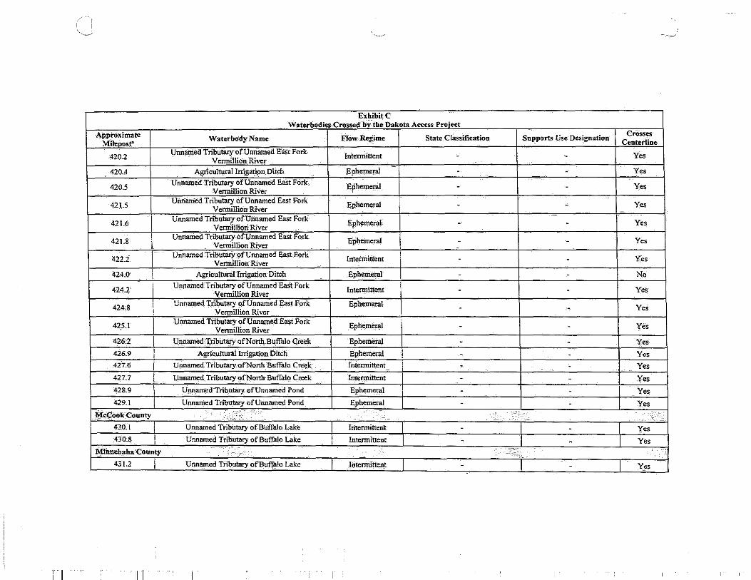
4202 Unnamed Tributacy-ofUnnamed East Fork Intermittent - - Yes
Vermillion River
420.4 Agricultural Irrigation Ditch Ephemeral - - Yes
420.5 Unnamed Tributary ofUnitamed EaSt Fork Ephemeral - - Yes
Vermillion River
421.5 Unnamed Tributary ofUnnamed East Fork Ephemeral - - Yes
Vermillion River
421.6 Unnamed TnOutary of Unnamed East Fork Ephemeral
vermillion River - - Yes
421.8 I Unnamed Tributary ofUnnamed East fork Ephemeral - - Yes Vennillion River
422.2 Unnamed Tributary of Unnamed East F-ork Intetmitreni - - Yes
Vermillion: River
424.0 Agricultural Iirigation Ditch Ephemeral - - No
424.2 Unnamed Triblltar:Y of Unnamed East Fork Intermittent - - Yes Vermillion River
424.8 Unname4 Tributary ofUnnamed East Fork Ephemenl - - Y~s Vennil1ion River
425.1 I Unnamed Tributary ofUnnamed East Fork Ephemeral - - Yes Vennillion River
426:2 I UnriamedTributary ofNorth.Buffalo Cn.\ek Ephemeral - - Yes
426.9 I AgriCultural Irrigation DitCh Ephemeral - - Yes 42'7.6 I Unnamed.Tributary.ofNonh Buffalo Creek Intermittent - . Yes
427.7 I Unnamed_ Tributary of North BuffaiQ Creek Intennittent - - Yes 428.9 I Unnamedlributary ofUnnamed Pond Ephemeral - - Yes
429.1 Unnamed TnOutary of Unnamed Pond Ephemeral - - Yes
.¥~ook:County :::\: ·.· • .. ~ . . '
430..1 Unnamed Tributary ofBuffillo Lake Intermittent . - I Yes 43'0.8 Unnamed Tributary of Buffalo Lake Intermittent - - I Yes
Mfnnebaha County .....
. . . :·-;,,_ ..... •
431.2 Unnamed Tributary ofBu:ffillo Lake Intermittent - I - I_ Yes
··111

-'
Exbibit'C Waterbodies Crossed by the Dakota Access-Project
Approximate Waterbody Name Flo,w_ Regime State Classific.atio~:~ Supports 'Us_e DeSignation Crosses
MilepQ.~f' centerline
431.8 TJnnamed Tributary of Buffalo Lake [ntermittent - - Yes
432.3 Unnamed Tributary of Buff~o Lake' Intermittent - - Yes
433.3 Unnamed Tributary-ofWest Branch Skunk Creek Ephemeral - - Yes
433.7 UilnamedTributary-ofWest Branch Skunk Creek Ephemeral - - Yes
434.2 UnnamedTributary of West Branch Skunk C:reek Intermittent - - Yes
434.9 AgriculturallrrigationJ)itch Ephemeral - - Yes
43.';.2 Ui:mamed· Tributary of West Stanch S~nk Creek Ephemeral - - Yes
435.4 Unnamed Tributary qfWest Branch Skunk Creek Ephemeral - - Yes
433.8 Uimam.ed'Tributacy .Of West 'Branch Skunk Ci"eek Ephemeral - - Yes
43.';.9 Agricultural lrrigation· ])itch Ephemeral - - Yes
436.2 West Brand1 Skunk Creek Intermittent . - - Yes
436.2 Unnamed Pond Open water - - No
436.4 Agricultural Irrigation Ditch Ephemeral - - Yes
4372 Uimamed Tributary of West Branch Skunk Creek lntermittent - - Yes
439.4 Agricultural IrrigatiQp Ditch EPhemeral - - Yes 439.5 Agricultural_Irrigation Dit<;:h Ephemeral - - Yes
439.7 AgriCUltural Irrigation Ditch Ephemeral - - Yes
440.7 Unnamed Tributary of West Branch Skunk Creek Ephemeral - - Yes 44-2.0 Unnamed Tributary of West Branch Skunk-Creek -Intermittent . . Yes
442.3 Unnamed Tributary of West-Branch Skunk Creek Intermittent - - Yes
445.4 Unnamed Tributary of West Bran~:trS:kunk Creek rnrermittent - - Yes 446.0 Agricultural Irrigation Ditch f:phemeral - - Yes
446.3 Unnamed TributarY ofSktink: Creek lritenriittent - - Yes 446.4 Unnamed Pond Open v.:ater - - No 447.1 Unnamed Tributary of Skunk Creek [ntennittent - - Yes 447.8 Unnamed-Tributary ofSkurik:Creek Intermittent - - Yes - -
i I 'liT

----J ·'-·-'
ExhibitC W-aterbodies Crossed by the D3.kota Access-P-rpject
Approximate Waterbody Name. Flow Regime Mil~st"'
State,Ciassiti_cation Supports Use Designation CrosSes Centerline
448.1 Unnamed Tributary ofSkunk Creek Jntennirtent - - Yes
448.8 Unnamed Tributary ofSlQink Cz:eek Intennitterit - - Yes
449:0 Unnamed Tributary of Skunk Cree~ -Intermittent - - Yes 449.4 Agrieulturallrrigation Ditch Ephemeral - - Yes I
449.7 Unnamed Tributary of Skunk Creek Intermittent - - Yes
450.8 Unnamed Tributary ofSlq.J.nk Creek lntenJ.tittent - - Yes
452.1 Unnamed Tributary of Wall Lake Intermittent - - Yes
452.4 Unnamed Tributar~/ofWall Lake lntennittent - - Yes
4535 Unnamed TributaryofWaU Lake Intermittent - - Yes
453.9 AgriculturaJ Irrigation Ditch Ephemeral - - Yes
454.0 Agricultural lrrigation Ditch Ephemeral - - Yes
454.6 Ufma:Jl?.ed Tributary of Unnamed ?ond Intermittent - - Yes
455.4 Unnamed Tn1mtary of Skunk Creek lntermittent - - Yes
455.8 Agricultural 'Irrigation Ditch Ephemeral - - Yes
:T~~C9unty •· .. ::• :· ,;:' .. ,·. ; . ·.: BO.l I Unnamed Tributary ofSkurik Creek I Intermittent I - - I Yes
't.;fu~hi COunty .
', .. . :::.. ·h:;.:: .. • ...... .. · .. .; . 41,2.2 Unnamed Tributary ofNine Mile Creek Ephemeral - - No
473.0 I Agri_cultural Irrigation Ditch I;.phemernl - - No
473.7 Unnamed Tributary of.Nine Mile Creek Intermittent - - Yes 474.0 Agriculturallr~igation Ditch Ephemeral - - Yes 474.6 Agricultural Irrigation Ditch Ephemeral - - Yes 475.0 Agricultural Irrigation Ditch Ephemeial - - Yes 476.4 Agricultural Irrigation Ditch Ephemeral - - Yes 477.0 Unnamed Tributary of Big SiOux River Intermittent - - Yes
478.7 Agriculturilllrrigation Ditch Ephemeial - - No -- - - --
, I Ill

~
EXhibitC Waterbodies Crossed by the_ Dakota Access Pl1)ject
Approximate Waterbody'Name Flow Regime State Classification Supports Use Designation Crosses
Milepost- Centerline'
478.9 Unnamed Tributary of'Big Sio_JIX River Intermittent - - No
4803 Unnamed Tributary ofBig-Sioux-River I ntennirient - - Yes
48!.5 Unname_d Tributary of Big Sioux River Ephemeral - - Yes
Fish/Wildlife PJop. Rec, Stock; Immetsion Recreation; Irrigation Full Support; Nonsupport;
48!.6 Big Sica"< River Perennial Waters; Li~ited E:()ntact Full Support; Nonsupport; HDIJli Recreation, Warmwater Nonsupport Semipermane-nt fish life
82.9 Unnamed Tributary ofBeaver Creek Intermittent - - Yes
B1.2 Agdcultural Irrigation Ditch Epheineral - - Yes
84.3 Unnamed Tribut;ary of BeaverCreek fntern:tittent - - Yes
84.4 AgriCultural Inigil.lion Ditch Epheme_ral - - Yes
85.2 Unn'arhed Tributary of Beaver Creek Ephemeral - - Yes
B5.9 Unnamed Ti-ibutary Of Beaver Creek Intehnittent - - Yes
88_1 Unnamed Tributary ofBeaver Creek Intennittent - - Yes
88.9 Unnamed Tributary ofBeaver_ Cieek llitermittent - - Yes
89.5 Unnamed Tributary -ofBeaver.Creek lntenninent - - Yes
Bl0.6 Unnamed Tributary o(Beaver Creek intermittent - - Yes
810.7 Unnamed Tributary ofBeaver Creek Intermittent - - Yes
BILl Agricultural lrrigation Ditch Ephemeral - - Yes
BII.S Uhnamed Tributary of Beaver Creek Intermittent - - Yes
812.9 Unnamed Tributary of-BeaverCreek Intermittent - - Yes
BIS.I Unnamed Tributary ·ofNine Mile Creek Intermittent - - Yes
Bl5.4 Unnamed Tributary ofNine Mile Cree_k Intermittent - - Yes a'Milepo,sts proceeded with the lette_r A reference the reroute in Spink County,- and mileposts proceeded with the· letter B 'reference the reroute in Turner and Lincoln cOunties. b HDD= Waterbody will be crossed via horizontal directional drill (HI) D). _ _ _
•·
1,11
- I I '
l
)
Federal and State Listed Threatened and Endangered Species in South Dakota

i' "-·-''
Northern long-eared bat
Interior least tern I
Piping plover I
Scientific Name
Myotis septentrionalis
Sterna antillarum athalassos
Charadrius melodus
I
I
Red knot I Calidris canutus I rufa
l I]
T
E I
T I
T I
Beadle, Campbell, Edmunds, Faulk, Kingsbwy, Lake, Lincoln, McCook, McPherson, Miner, Minnehaha, Spink,
Turner
Campbell
Campbell, Kingsbwy
Beadle, Campbell, Edmunds, Faulk, Kingsbwy, Lake, Lincoln, McCook, McPherson, Miner, Minnehaha, Spink,
No effect
I No effect I
I No effect I
No effect
Summer roosting habitat underneath bark or in crevices of live and dead trees. Winter
habitat includes caves and mines with large entrances.
.u.n .... uv~ '"'"""'~ ....,,u u ... ~~LLIQ navu.u~ .. ,.,.,..,_.,..,."'
open shorelines, riverine sandbars, and mudflats along Missouri and Mississippi
Sandy or gravelly beaches and sandbars or alkaline wetlands.
Breeds in the Arctic tundra areas, such as sparsely vegetated habitat. When non-
breeding they prefer primarily intertidal, marine habitats, coastal inlets, estuaries, and
bays.
I
,~
Determination of Effect
The USFWS has issued an interim 4( d) rule. The implementation of the interim 4( d) rule for the northern long-eared bat
exempts certain activities within the white nose syndrome (WNS) buffer zone- those
areas within 150 miles ofWNS-positive counties - provided certain conservation
measures are implemented. In areas outside ofthe !50-mile WNS buffer zone,
incidental take from lawful activities would be exempted. All of South Dakota
is outside of the WNS 150-mile buffer zone; thus, construction and operation of
the Project area within South Dakota would be exempt from the Endangered
.e prohibition O<i1_~;~>,;o.~ • 'V::S
The Project does not cross the Missouri River within South Dakota. No suitable
habitat within the Project area.
No suitable during Project field surveys. I Critical habitat for the piping plover is
along the Missouri River; the Project does not cross the Missouri River within South Dakota. This species is highly mobile and
J would likely avoid the constructi
j No suitable habitat within the Project area

]
Sprague's pipit
Whooping crane
Pallid sturgeon
I
Scientific Name
Anthus spragueii
Grus americana
Scaphirhynchus a/bus
ill
c
E
E
Campbell, McPherson
Beadle, Campbell, Clark, Edmoods,
Faulk, Kingsbury, McCook,
McPherso~ Miner, Spink, Turner
Campbell, Lincoln
No effect
No effect
May affect, not likely to
adversely affect
. 'I"'"''
I
height and sparse to intermediate vegetation density, low forb density, and little bare groood but low litter depth. Introduced
grasslands may be utilized, but to a much lesser extent. Nests on the ground from early
During migration, this species utilizes wetlands and cropland ponds for feeding and
roosting. Seasonal and semi-permanent wetlands are the most commonly used.
Prefer a fast flowing turbid river with a firm sand or gravel bottom. Areas at the end of chutes or sandbars are commonly used for
feeding.
~·
Determination of Effect
Breeding habitat range is in the northern part of the state. Some of the Project area may be within this range; however. there
are no occurrences documented within the Project area (SDNHP, 2014 and eBird,
2014)
area range of this species (Cornell
Ornithology, 2014). Only one whooping crane occurrence record is located in
Kingsbury Coooty whhin one mile of the Project (SDNHP, 2014). This species is
highly mobile and would likely avoid
will not be crossed in South Dakota, the Big Sioux River (Lincoln Coooty) will be crossed via HDD. Dakota Access plans
to withdraw water from the Big Sioux River for HDD installation activities and hydrostatic testing of the HDD segroent.
Dakota Access would implement conditions on permitted intake structures at the Big Sioux River as described in the
USFWS Recovery Plan for the Pallid Sturgeon (USFWS, 2014). Potential
indirect impacts on pallid sturgeon would be avoided and minimized through
implementation of the HDD Contingency Plan.

I
~
Topeka shiner
Dakota skipper
Western prairie fringed
orchid
E= Endangered T= Threatened c~ Caodidate
Scientific Name
Notropis topeka
Hesperia dacotae
Platanthera praeclara
111
E
T
T
Beadle, Kingsbury, Lake, Lincoln,
McCook, Miner, Minnehaha, Spink,
Turner
Edmunds, McPherson
Lake, Lincoln, McCook, Miner,
Minoehaha, Turner
. ''I'
'
May affect,
likely to adven;ely
affect
No effect
No effect
Habitat Requirement
Found in small prairie streams that exhibit perennial or nearly perennial flow. Substrate
usually is clean gravel, cobble, or sand.
Dakota skippers only utilize high quality undisturbed (i.e., remnant, uncultivated)
prairie; including, wet tallgrass prairie and
Prefers moist tallgrass prairie and sedge meadows.
--/
Determination of Effect
waterbodies crossed by the South Dakota were identified by the
USFWS as containing known occurrences (James River, Shue Creek, Pearl Creek,
Middle Pearl Creek, Redstone Creek, Rock Creek, West Fork Verntillion River, East Fork Vermillion River, and Big Sioux
River). Four waterbodies (James River, Pearl Creek, East Fork Vermillion River, aod Big Sioux River) would be crossed using HDD construction methods, thus avoiding direct adverse effects at these
locations. Field surveys of the remaining five waterbodies identified that one of
these waterbodies, the West Fork Vermillion, would be crossed at the
headwaters of the stream where it is an emergent wetland with no perennial flow.
Therefore, the West Fork Vermillion River is not suitable habitat for the species. The
four remaining streams (Shue Creek, Redstone Creek, Middle Pearl Creek, aod Rock Creek) include known occurrences
tial suitable spawning habitat. ::.: !-';~-::~-~:itt~~;,~~~~~~~I~~~~,~1:{~'$:
No native grasslands were identified within Edmunds and McPherson counties
during :field surveys.

"-~· ~/
acres or Black-footed I Mustela nigripes I E I No impact more) prairie dog towns. Use burrows for shelter
ferret anticipated and feed on prairie dogs and other species within a the habitat. within the Pro· ect area
Within the Project area, this species has b documented within the Big Sioux River and James
Northern river I Lontra I I No impact I Rivers with high quality water and an abundant
1
River watersheds (South Dakota Game, Fish, and Parks T [SDGFP], 2014a and South Dakota Natural Heritage
otter canadensis anticipated food supply. Program [SDNHP], 2014). However, both of these rivers will be crossed via HDD, therefore avoiding im acts to the riverine habitats utili
""T- ~----.. Prefer short or mixed grass prairies with flat to Although historically the range oft Swift fox Vulpes velox T
American I Cinclus I I No impact
1
stone, or sand bottoms which support invertebrates. T Streams with structures over the water such as
dipper mexicanus anticipated waterfalls, rocks and boulders are needed for
nestin . There are few forested areas
Breeds and winters in areas close to a coast, river nesting. Occurrence data from the SDNHP documented
Bald eagle I Haliaeetus I T I No impact I or lake. Prefers conifers for nesting and roosting
a nest approximately one mile from the Project area. leucocephalus anticipated and tends to avoid areas with high human traffic.
Field surveys did not identify bald eagles within the Project area This species is highly mobile and would
likely avoid construe! '1'1..- n __ ; __ .. ---- :_ ... :..t.:_ ... t._ ' Eskimo I Numenius
E No impact
Variety of grassland habitats. curlew borealis anticipated
•..uvvuv ....._....., ., ... ...,,
Interior least I UJ'f:;f t<U
I I No impact Interior least tern nesting habitat includes open The Project does not cross
tern antillarum E
anticipated shorelines, riverine sandbars, and mudflats along South Dakota. No snitable habitat within the Project .. Missouri and Mississippi Rivers drainages . area. Prefer habitat near water including, saltmarshes, The Project area is within the migratory range of this
Osprey I Pandion I T I No impact rivers, ponds, and reservoirs. Osprey places their species (Cornell Lab of Ornithology. 2014). This haliaetus anticipated nest in open areas on poles, channel markers, and species is highly mobile and would likely avoid
I I , I! I
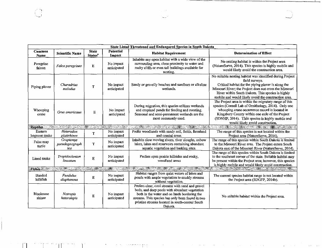
"-~J ---' ____ j
Scientific Name I .;I LA ..... I .a.u .. ...-.. ., .... I Habitat Requirement I Determination of Effect ~· . . T ----'
Inhabits any open habitat with a wide view of the
I No nesting habitat is within the Project area
Peregrine I Falco peregrines I E I No impact
I surrounding area, close proximity to water and
(NatureServe, 2014). This species is highly mobile and falcon anticipated rocky cliffs or even tall buildings available for
would likely avoid the construction area
~ habitat was field surveys.
Piping plover I Charadrius I T I
No impact I Sandy or gravelly beaches and sandbars or alkaline I Critical habitat for the piping plover is along the melodus anticipated wetlands. Missouri River; the Project does not cross the Missouri
River within South Dakota. This species is highly construction ar~
The Project area is within the migratory range of this During migration, this species utilizes wetlands species (Cornell Lab of Ornithology, 2014). Only one
Whooping I Grus americana I E I No impact
I and cropland ponds for feeding and roosting. whooping crane occurrence record is located in
crane anticipated Seasonal and semi-permanent wetlands are the Kingsbury County within one mile of the Project most commonly used. (SDNHP, 2014). This species is highly mobile and
would likel avoid
T Noi~ ........ .-..-antic
T No impact anticipated
Lined snake I Tropidoclonion I E I No impact Prefers open prairie hillsides and rocky, lineatum anticipated woodland areas
Banded I Fundulus
I I No impact
Habitat ranges from quiet waters of lakes and The current species habitat range is not located within
killifish diaphanous E
anticipated ponds with ample vegetation to muddy streams
the Project area (SDGFP, 2014b) . .. .:.-~-.out ve etation. streams with sand and gravel
beds, and deep pools with abundant vegetation Blacknose I Notropis
I E I No impact
I both in the water and on lands bordering the
I No suitable habitat within the Project area shiner heterolepis anticipated streams. This species has only been found in two pristine streams located in south-central South
Dakota.
Ill

, __ ---- ---, ---- -·- I -
State Listed Threatened and Endangered Species in South Dakota Common Scientific Name
State Potential Habitat Requirement Determination of Effect
Name Statu sa Impact Occur most often in cool, clear mountain streams
Finescale dace Chrosomus
E No impact and less often in lakes, reservoirs, or large rivers. The Project area is outside of the current species range
neogaeus anticipated Prefer moderate water velocities, associate with a (NatureServe, 2014). variety of substrates.
Longnose Catostomus No impact Found in cool, spring-fed streams where it feeds on
The Project area is outside of the current species range T the bottom on crustaceans, snails, insect larvae, and
sucker catostomus anticipated larvae.
(NatureServe, 2014).
Northern pearl Margariscus No impact Occurs in cool bogs, ponds, lakes, and clear The species distribution is not located within the Project
T area Limited to Counties within southwestern South dace nachtriebi anticipated streams.
Dakota (U.S. Geological Survey, 2014b) Northern
Chrosomus eos T No impact Prefers areas with beds of aquatic vegetation in Believed to be extirpated from the Big Sioux drainage
redbelly dace anticipated spring-fed streams. (SDGFP, 2014c)
Prefer a fast flowing turbid river with a firm sand The Missouri River (Caropbell County) will not be Pallid Scaphirhynchus
E No impact
or gravel bottom. Areas at the end of chutes or crossed in South Dakota, and the Big Sioux River
sturgeon alb us anticipated sandbars are commonly used for feeding.
(Lincoln County) will be crossed via HDD, therefore no impacts will occur to this species.
Macrhybopsis No impact Prefer large, turbid rivers with a diversity of depths
Sicklefin chub meeki
E anticipated
and velocities forming braided channels, sand bars, No suitable habitat within the Project area sand flats, and gravel bars.
Macrhybopsis No impact Prefer large, turbid rivers with a range of depths
Sturgeon chub gelida
T anticipated
and velocities forming braided channels, gravel No suitable habitat within the Project area. bars, and sand flats and bars.
E Endangered T= Threatened • South Dakota state listed species do not have county listings, they are listed state-wide.
'
! . Ill
.. _ _.J.
REFERENCES:
Cornell Lab of Ornithology. 2014. All About Birds. http://www.allaboutbirds.org/guide/search. Accessed November and December 2014.
eBird. 2014. eBird Observation Maps. http://ebird.org/ebird/map/. Accessed November and December 2014.
NatureServe. 2014. NatureServe Explorer. http://explorer.natureserve.org/. Accessed December 2014.
South Dakota Natural Heritage Program. 2014. South Dakota Game, Fish, and Parks, Wildlife Diversity Program. Occurrence data within 2 miles of pipeline route. Received July 2014.
South Dakota Game, Fish, and Parks. 2014a. Northern River Otter. http://gfi:>.sd.gov/wildlife/management/diversity/river-otter.aspx. Accessed December 2014.
South Dakota Game, Fish, and Parks. 2014b. Banded Killifish. http://gip.sd.gov/wildlife/critters/fishlrare-fish/banded-killifish.aspx. Accessed December 2014.
South Dakota Game, Fish, and Parks. 2014c. Northern Redbelly Dace. http://gfi:>.sd.gov/wildlife!critters/fish!rare-fishlnorthernredbelly-dace.aspx. Accessed November 2014.
U.S. Fish and Wildlife Service. 2015. Western Prairie Fringed Orchid (Platanthera praeclara). http://www.fws.gov/northdakotafieldoffice/endspecies/species/western__prairie _fringed_ orchid.htm. Accessed September 2015.
U.S. Fish and Wildlife Service. (2014). Revised Recovery Plan for the Pallid Sturgeon (Scaphirhynchus a/bus). Accessed February 2015 from http://ecos.fws.gov/docs/ recovery __plan!Pallid%20Sturgeon%20Recovery%20Plan%20First%20Revision%20signed%20version%200 12914 _3.pd£
U.S. Geological Survey. 2014a. North Dakota's Federally Listed Endangered, Threatened, and Candidate Species- 1995. Western Prairie Fringed Orchid (Platanthera praeclara). http://www.npwrc.usgs.gov/resource/wildlife/nddanger/species/platprae.htm. Accessed December 2014.
Ill.
I

i I
U.S. Geological Survey. 2014b. Endangered, Threatened, & Rare Animals in South Dakota. http://www.npwrc.usgs.gov/resource/wildlife/sdrare/species/semomarg.htm. Accessed November 2014.
Ill. I