public notice (12-15) waterway and … · united states coast guard seventh district ... their...
TRANSCRIPT
PUBLIC NOTICE (12-15)
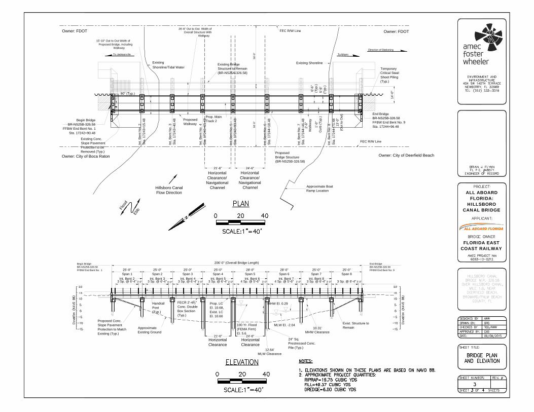
All interested parties are notified that the Commander, Seventh Coast Guard District has received an application Amec Foster Wheeler Environment & Infrastructure, Inc., on behalf of All Aboard Florida, requesting approval of the location and plans for the modification of an existing bridge over a navigable waterway of the United States. WATERWAY AND LOCATION: Hillsboro Canal, mile 1.6, near Deerfield Beach, FL. Latitude 26°19’22.23” N, Longitude 80°05’55.82” W (26.322842,-80.098839). CHARACTER OF WORK: The proposed project includes the addition of a single-track railroad bridge and associated pilings built to the west of and parallel to the existing single track railroad bridge. The piles will be constructed directly in line with the existing piles. The out-to-out width of the proposed new structure is approximately 15’ 6”. The existing railway bridge is currently used for freight transport. The proposed bridge is necessary in order to create a double-track for use as a passenger rail corridor. The existing bridge will remain in use as part of the freight corridor. MINIMUM NAVIGATIONAL CLEARANCES: Existing Proposed Horizontal: Horizontal: 24.5 ft between face of piles 24.5 ft between face of piles Vertical: Vertical: 10.31 ft above Mean High Water 10.31 ft above Mean High Water 12.64 ft above Mean Low Water 12.64 ft above Mean Low Water ENVIRONMENTAL CONSIDERATIONS: The Federal Railroad Administration (FRA), the lead federal agency, approved a Final Environmental Impact Statement (FEIS) on 4 August 2015 for the purposes of the National Environmental Policy Act. The FEIS and associated documents are available for review at the above address, Monday through Friday, 7:30 a.m. to 4:00 p.m. The bridge is located in the floodplain. The 100-year flood elevation is 5.6 ft. and the bridge low member elevation is 10.68 ft; elevations are reference to NAVD 88 datum. The area surrounding the project site is primarily mowed and covered in riprap in association with the existing bridge. Vegetation in the project area is dominated by invasive Brazilian pepper. Australian pine and White mangrove are present in the surrounding area. In accordance with the SFMWD and USACE guidelines, the project will not impact wetland resources within Palm Beach or Broward counties. Under Broward County
Commander United States Coast Guard Seventh District
909 SE 1st Avenue Miami, Florida 33131 Staff Symbol: (dpb) Phone: (305) 415-6736 Fax: (305) 415-6763 Email: [email protected] 16591/2457 October 1, 2015

2
Environmental Protection and Growth Management Department (BCEPGMD) guidelines, 0.004 acres of White mangrove will be permanently impacted. As such, BCEPGMD is requiring the applicant to purchase saltwater credits from the Everglades mitigation bank to offset the impacts. The South Florida Water Management District (SFWMD) is the certifying agency, as defined in 40 CFR § 121.1(e), for issuance of Water Quality Certification (WQC) pursuant to Section 401, Public Law 92-500, 33 U.S.C. Section 1341. The SFWMD issued Environmental Resource Standard General Permit (ERP) No. 13-05321-P dated 7 March 2014. The USACE is reviewing the application for a nationwide permit. The proposed project does not involve any demolition and is not expected to impact any historic properties listed or eligible for listing in the National Register of Historic Places. Preliminary analysis indicates that the project would not result in adverse effects as described in Section 106 of the National Historic Preservation Act of 1966. A concurrence letter was issued by the Florida Department of State dated 6 November 2012. A Biological Assessment (BA) was completed and submitted in September 2013 for species under USFWS and NMFS jurisdiction. The USFWS is currently reviewing the BA for species under their jurisdiction. NMFS has issued a concurrence letter with respect to the Endangered Species and Biological Assessment dated 26 February 2015. Temporary impacts to navigation during construction are anticipated. Navigational impacts include crane barges working in and around the navigation channel and intermittent reoccurring blockage of the navigation channel. Mariners will be notified of the details of in-water construction activities which will impact the navigation channel at and around the bridge site. Details of navigational impacts including dates and durations of full and partial channel blockage will be disseminated to mariners via the Coast Guard’s Local Notice to Mariners (LNM). SOLICITATION OF COMMENTS: Mariners are requested to comment on the proposed vertical and horizontal navigational clearances and other navigational safety issues, including but not limited to impacts due to construction activities. Interested parties are requested to express their views, in writing, on the proposed bridge project including its possible impact on minority and/or low income population, if any, giving sufficient detail to establish a clear understanding of their reasons for support of, or opposition to, the proposed work. Comments will be received for the record at the office of: Commander (dpb), Seventh Coast Guard District, 909 SE 1st Ave., Ste 432, Miami, Florida 33131-3028, for a 30-day period from the date of this public notice. Our project manager for this application is Mr. Randall Overton. He can be contacted by telephone at (305) 415-6736, by mail at the above address, or e-mail at [email protected]. Comments received will be made part of the case record. Map of location and plans attached.

ALL ABOARDFLORIDA:
HILLSBOROCANAL BRIDGE
FLORIDA EASTCOAST RAILWAY

ALL ABOARDFLORIDA:
HILLSBOROCANAL BRIDGE
FLORIDA EASTCOAST RAILWAY
FEC R/W Line
FEC R/W Line
Proposed
Walkway
Int. Bent 3 Int. Bent 4 Int. Bent 5 Int. Bent 6 Int. Bent 8
Existing
Shoreline/Tidal Water
Existing Shoreline
Approximate
Existing Ground
Handrail
Post
(Typ.)
Exist. Structure to
Remain
FECR 2'-4
1
2
"
Conc. Double
Box Section
(Typ.)
24" Sq.
Prestressed Conc.
Pile (Typ.)
100 Yr. Flood
(FEMA Firm)
El. 5.6
Temporary
Critical Steel
Sheet Piling
(Typ.)
Int. Bent 2 Int. Bent 7
Prop. LC
El. 10.68,
Exist. LC
El. 10.60
Begin Bridge
BR-NS25B-326.58
FFBW End Bent No. 1
Sta. 17242+90.48
Existing Bridge
Structure to Remain
(BR-NS25A-326.58)
Proposed
Bridge Structure
(BR-NS25B-326.58)
Proposed Conc.
Slope Pavement
Protection to Match
Existing (Typ.)
Existing Conc.
Slope Pavement
Protection to be
Removed (Typ.)
End Bridge
BR-NS25B-326.58
FFBW End Bent No. 9
Sta. 17244+96.48
Prop. Main
Track 2
6'-6"
(T
yp.)
1'-0"
Curb (T
yp.)
13'-0"
(O
ut to O
ut)
5'-6"
(T
yp.)
50
'-0
"
206'-0" (Overall Bridge Length)
25'-0"
Span 1
2'-6"
Walkw
ay
90° (Typ.)
Int. B
ent N
o. 3
Sta. 17243+
40.48
Int. B
ent N
o. 4
Sta. 17243+
65.48
Int. B
ent N
o. 5
Sta. 17243+
90.48
Int. B
ent N
o. 6
Sta. 17244+
18.48
Int. B
ent N
o. 7
Sta. 17244+
46.48
Begin Bridge
BR-NS25B-326.58
FFBW End Bent No. 1
End Bridge
BR-NS25B-326.58
FFBW End Bent No. 9
Int. B
ent N
o. 2
Sta. 17243+
15.48
Int. B
ent N
o. 8
Sta. 17244+
71.48
50
'-0
"
25'-0"
Span 2
25'-0"
Span 3
25'-0"
Span 4
28'-0"
Span 5
28'-0"
Span 6
25'-0"
Span 7
25'-0"
Span 8
3 Sp. @ 6'-4" 3'-0" 3 Sp. @ 6'-4"
3'-0"
3 Sp. @ 6'-4" 3'-0" 3 Sp. @ 6'-4"3'-0"
4 Sp. @ 5'-6" 3'-0" 4 Sp. @ 5'-6" 3'-0" 3 Sp. @ 6'-4" 3'-0" 3 Sp. @ 6'-4" 3'-0"
24'-6"
24'-6"
14'-0"
21'-6"
21'-6"
26'-6" Out to Out Width of
Overall Structure With
Walkway
15'-10" Out to Out Width of
Proposed Bridge, including
Walkway
MLW El. -2.04
MHW El. 0.29
Approximate Boat
Ramp Location
10.31'
MHW Clearance
12.64'
MLW Clearance
ALL ABOARDFLORIDA:
HILLSBOROCANAL BRIDGE
FLORIDA EASTCOAST RAILWAY
Hillsboro Canal
Flow Direction
Owner: City of Deerfield Beach
Owner: City of Boca Raton
Owner: FDOT
Owner: FDOT
Horizontal
Clearance/
Navigational
Channel
Horizontal
Clearance
Horizontal
Clearance
Horizontal
Clearance/
Navigational
Channel
E
b
b
F
l
o
o
d

ALL ABOARDFLORIDA:
HILLSBOROCANAL BRIDGE
FLORIDA EASTCOAST RAILWAY