public hearings november 4, 6, 10 & 12, 2014 · ties into existing thedford 115 kv substation...
TRANSCRIPT

Public HearingsNovember 4, 6, 10 & 12, 2014

11/12/2014 2
Randy LindstromTransmission Planning Supervisor
Nebraska Public Power District

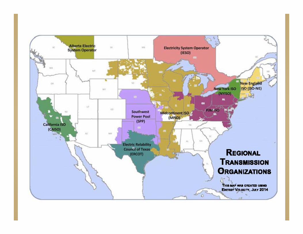
SPP is a FERC Approved Regional Transmission Organization
Monitor the Regional Grid to Maintain Reliability Process Requests for Generator Interconnections and
Transmission Service Across the Region Operate Integrated Market Planning Coordinator For The Nine State SPP Region NPPD is a Member of SPP

Three Year study process to assess long-term and near-term needs of SPP Transmission System
Objective is to develop a cost-effective, flexible, and robust transmission network that provides efficient, reliable access to diverse generation resources
Promotes transmission investment that meets reliability, economic and public policy needs
ITP20-Year & ITP10-Year Plans are developed every three years and the ITP Near-Term Plan is developed every year
5
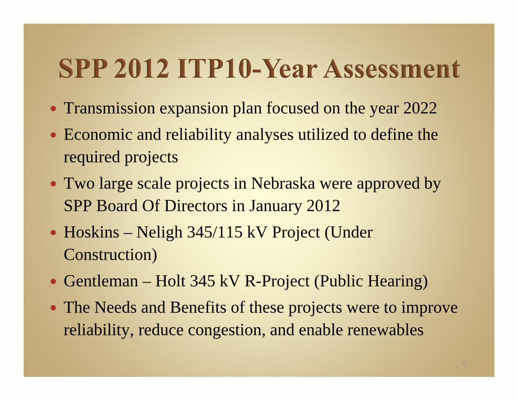
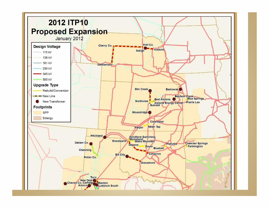
Transmission expansion plan focused on the year 2022 Economic and reliability analyses utilized to define the
required projects Two large scale projects in Nebraska were approved by
SPP Board Of Directors in January 2012 Hoskins – Neligh 345/115 kV Project (Under
Construction) Gentleman – Holt 345 kV R-Project (Public Hearing) The Needs and Benefits of these projects were to improve
reliability, reduce congestion, and enable renewables
6
During the Summer of 2012, NPPD experienced severe hot and dry weather conditions across the entire system
Resulted in extreme system peak load levels NPPD set all-time record summer peak load levels
which were nearly 400 MW greater than 2011 North Central Nebraska area (Zone 5) experienced
unprecedented loads due to irrigation demand There were load delivery issues in Zone 5 due to
limited transmission capacity

North Central Nebraska area (Zone 5) consists of high concentration of electric irrigation load
115 kV Transmission ring connected to stronger sources via limited capacity, high impedance lines
During contingency events of these source lines, or connections within the ring, thermal overloads and voltage depressions can occur
These issues jeopardize the future ability to reliably serve the local area loads during peak loading conditions

In 2013, SPP Board of Directors directed this study in response to potential high incremental load additions in the SPP region
Oil and Gas development in New Mexico, Texas and Oklahoma and irrigation load growth in Nebraska
These new loads had not been accounted for in previous ITP studies
Cost effective transmission plan was developed to address reliability needs over a 10-year period under updated loads
High Priority Incremental Load Study was approved by SPP in 2014 and the Thedford 345/115 kV Project was included
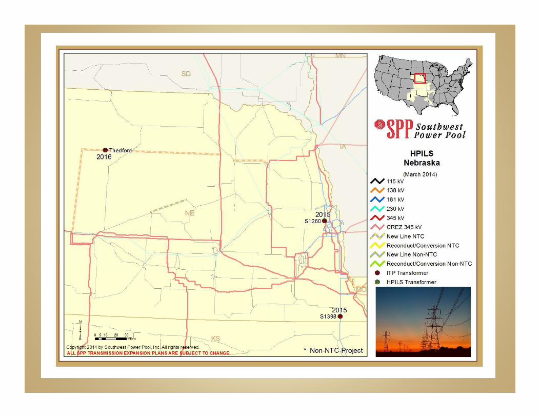

New Thedford 345 kV Substation and new Thedford345/115 kV 417 MVA Transformer
Ties into existing Thedford 115 kV Substation to provide a new high capacity feed on the west side of Zone 5
Thedford project is needed to address thermal overloads and voltage violations during contingency events in Zone 5
Thedford plan focused on maximizing the reliability benefits of the R-Project facility additions

220 miles of new 345 kV transmission line and new 345 kV interconnections at Thedford and Holt County
Provides significant reliability benefits by addressing the worst case GGS area stability issues and the future Zone 5 load delivery issues
Provides congestion relief by increasing west – east transfer capability across the NPPD transmission system
Provides transmission capacity to allow interconnection of new renewable generation projects
Provides a new bulk transmission path to address thermal and voltage issues identified along the Gentleman – Grand Island transmission corridor
14

R-Project needed to improve the Reliability of the Nebraska transmission system for future load delivery service
R-Project needed to Reduce Congestion on the existing Nebraska transmission system to improve future generation delivery service
R-Project needed to provide new transmission capacity to enable future Renewable generation interconnection and delivery service
The Nebraska Power Review Board approved NPPD’s application for authority to construct this project on October 10, 2014
11/12/2014 17
Aaron AmesDepartment Manager/Analyst
POWER Engineers, Inc.
11/12/2014 18
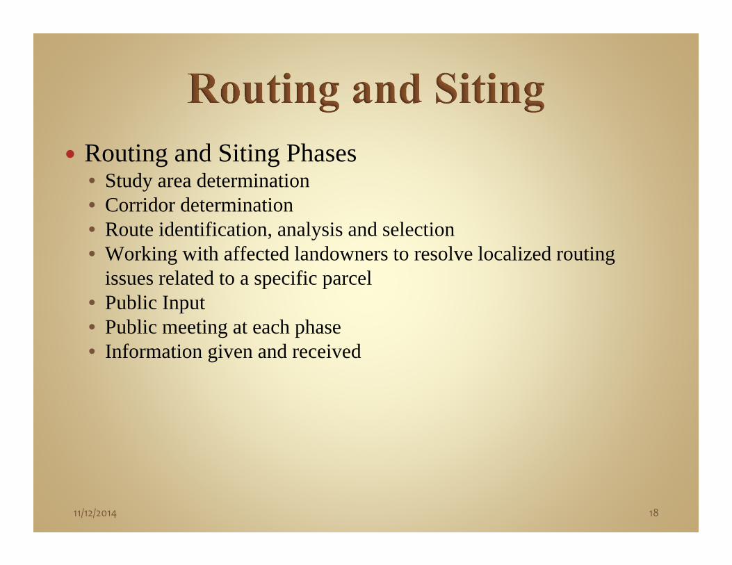
Routing and Siting Phases• Study area determination• Corridor determination• Route identification, analysis and selection• Working with affected landowners to resolve localized routing
issues related to a specific parcel• Public Input• Public meeting at each phase• Information given and received
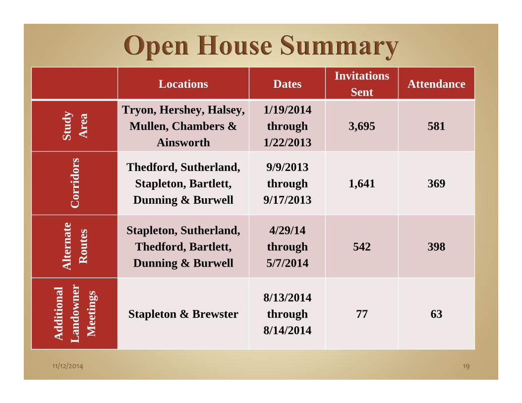
Locations DatesInvitations
SentAttendance
Stud
y A
rea Tryon, Hershey, Halsey,
Mullen, Chambers &Ainsworth
1/19/2014 through
1/22/20133,695 581
Cor
rido
rs Thedford, Sutherland,Stapleton, Bartlett, Dunning & Burwell
9/9/2013 through
9/17/20131,641 369
Alte
rnat
e R
oute
s Stapleton, Sutherland, Thedford, Bartlett,Dunning & Burwell
4/29/14 through 5/7/2014
542 398
Add
ition
al
Lan
dow
ner
Mee
tings
Stapleton & Brewster8/13/2014 through
8/14/201477 63
11/12/2014 19

11/12/2014 20
Preliminary Study Area Determination Data Acquisition Field Reconnaissance Final Study Area Determination

11/12/2014 21
Reviewed the Study Area and Project • Agency scoping meetingsObtained agency input and data from US Fish and Wildlife Service,
Nebraska Game and Parks Commission, Nebraska Department of Roads, US Army Corps of Engineers, Nebraska Historical Society
• Public outreach meeting and community leader briefings• Study Area Public Meetings• Public comment and dataObtained comment and feedback, provided project information

11/12/2014 22

11/12/2014 23
Summary of Results from Study Area Public Meeting• Minimize impacts to residences• Minimize impacts to farm and ranch operations• Acquired data on new and planned center pivots, residence
locations, cemeteries, and land use
11/12/2014 24
Detailed Data Acquisition• High resolution aerial photography of Study Area • Field verification of information Initial public commentPublic data sources
• Identification of potential river crossings Determination of Initial Corridors Review Meeting and Determination of Final Corridor
11/12/2014 25
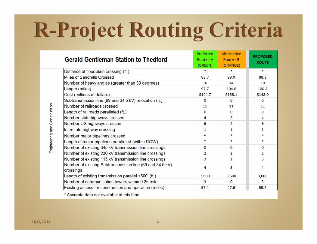
Determined Routing Criteria Key Criteria
• Proximity to homes• Proximity to Towns and Villages• Existing Access• Center pivot conflicts• Shelterbelts• Field bisections• Wetlands/Jurisdictional waters• Length• Cost• Heavy Angles
Conducted Analysis of Data based on the Criteria

11/12/2014 26
Proximity to Occupied ResidencesNumber less than 300 ft.Number over 300 ft. & less than 500 ft.Number over 500 ft. & less than 0.25 mile
Proximity to Towns/VillagesNumber less than or equal to 0.25 mileNumber over 0.25 mile & less than or equal to 0.5 mileNumber over 0.5 mile & less than 1 mile
Proximity to Other AmenitiesNumber of churches within 500 ft.Number of schools within 0.25 mileNumber of cemeteries within 500 ft.Public use airports (landing strip > 3200 ft.) within 1.5 milesPublic use airports (landing strip < 3200 ft.) within 1.25 milesPrivate FAA registered airports within 1.25 milesPrivate non-FAA registered airports within 0.5 mile
Land Use CriteriaWellheads within ROW of apparent centerlineNumber of other buildings within ROWProximity to platted developmentLength adjacent to platted development (ft.)Irrigated cropland crossed (acres in ROW)Pasture/rangeland crossed (acres in ROW)Dry land crops crossed (acres in ROW)Number of center pivot conflictsCultivated field bisections
Other Land UseNumber of parcels crossed by ROW Number of land owners affected by ROW

11/12/2014 27
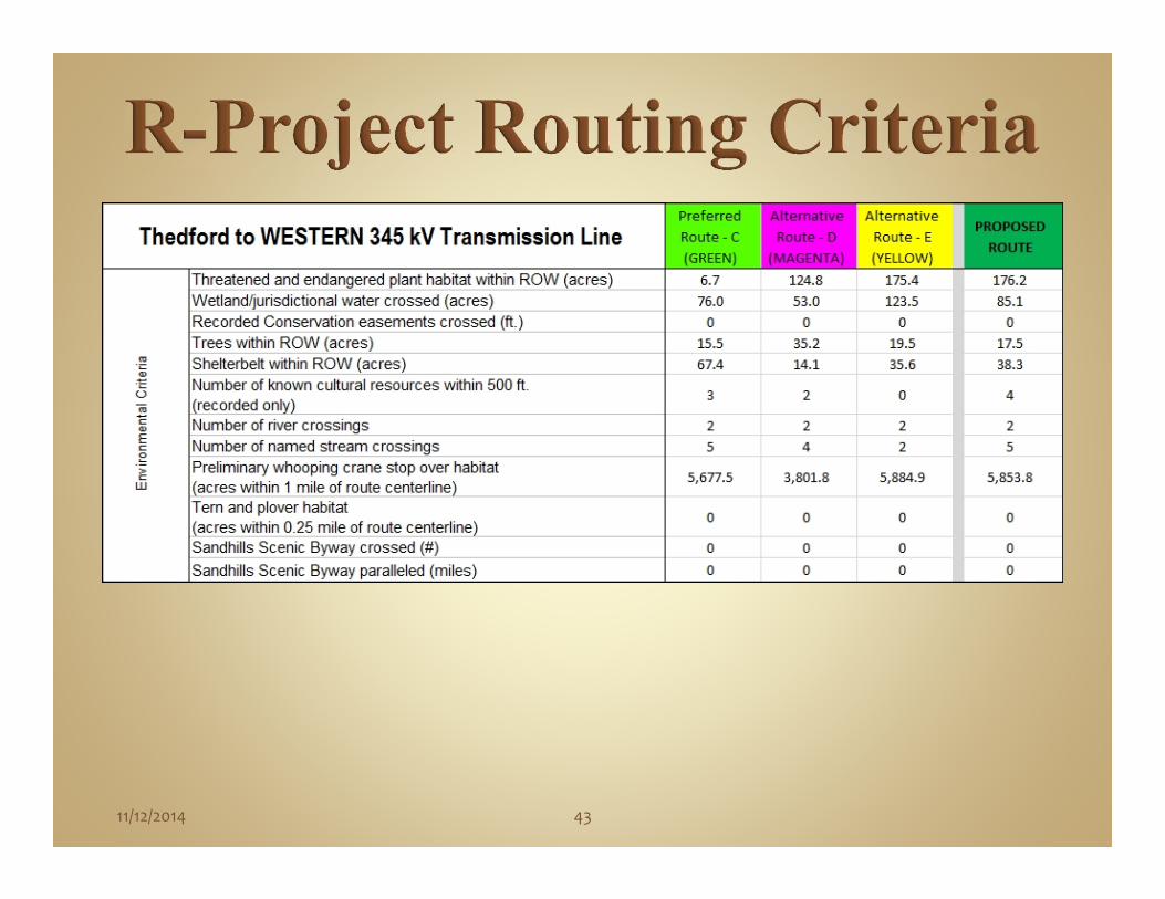
Environmental CriteriaThreatened and endangered plant habitat within ROW (acres)Wetland/jurisdictional water crossed (acres)Recorded Conservation easements crossed (ft.)Trees within ROW (acres)Shelterbelt within ROW (acres)Number of known cultural resources within 500 ft. (recorded only)Number of river crossingsNumber of named stream crossingsPreliminary whooping crane stop over habitat (acres within 1 mile of route centerline)Tern and plover habitat (acres within 0.25 mile of route centerline)Sandhills Scenic Byway crossed (#)Sandhills Scenic Byway paralleled (miles)
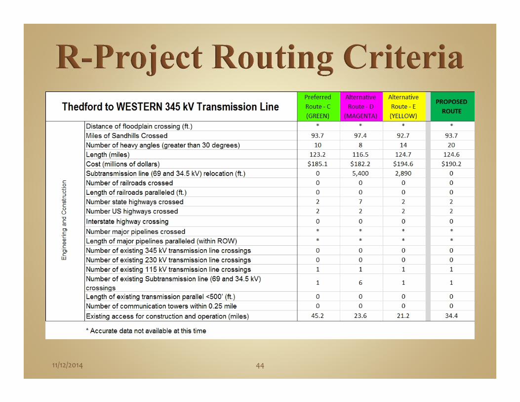
Engineering and ConstructionDistance of floodplain crossing (ft.)Miles of Sandhills CrossedNumber of heavy angles (greater than 30 degrees)Length (miles)Cost (millions of dollars)
Subtransmission line (69 and 34.5 kV) relocation (ft.)Number of railroads crossedLength of railroads paralleled (ft.)Number state highways crossedNumber US highways crossedInterstate highway crossingNumber major pipelines crossedLength of major pipelines paralleled (within ROW)Number of existing 345 kV transmission line crossingsNumber of existing 230 kV transmission line crossingsNumber of existing 115 kV transmission line crossingsNumber of existing Subtransmission line (69 and 34.5 kV) crossingsLength of existing transmission parallel <500’ (ft.)Number of communication towers within 0.25 mileExisting access for construction and operation (miles)

11/12/2014 28
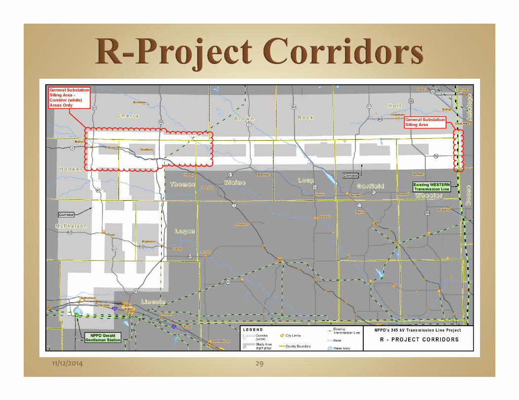
Corridor Selection• Selected corridors to minimize conflictsAvoidance of population density Minimizing impacts to agricultural land and center pivotsAvoidance of residencesRiver CrossingsAvoidance of wetlands
• Selected corridors that would provide for routing flexibility• Selected corridors that would provide substation siting
opportunities• Mapped corridors
11/12/2014 29
11/12/2014 30
Agency Scoping Conducted Second Public Outreach Meeting and
Briefings of Community Leaders Conducted Corridor Public Meetings Conducted Detailed Data Acquisition Conducted Additional Field Verification of
Information

11/12/2014 31
Input data collected into a Geographic Information System (GIS)
Determined Potential Route Links Screened Potential Route Links Determined Potential Routes Evaluated and Screened Potential Routes

11/12/2014 32
Route Screening Route alternatives developed Project team reviewed and further evaluated
alternatives

11/12/2014 33

Conducted Third Set of Public Outreach and Community Leader Meetings
Conducted Alternative Route Public Meetings Obtained Public Comment Specific to Route
Alternatives
Routing and Siting
11/12/2014 34

• Additional Landowner meetings held• Invitations sent to potentially affected landowners• Comments specific to alternative routes were taken
1811/12/2014 35

11/12/2014 36
Reviewed over 2,200 Public Comments Final Route Evaluation Final Proposed Route Selection

11/12/2014 37

11/12/2014 38

11/12/2014 39

11/12/2014 40
11/12/2014 41

11/12/2014 42
11/12/2014 43
11/12/2014 44
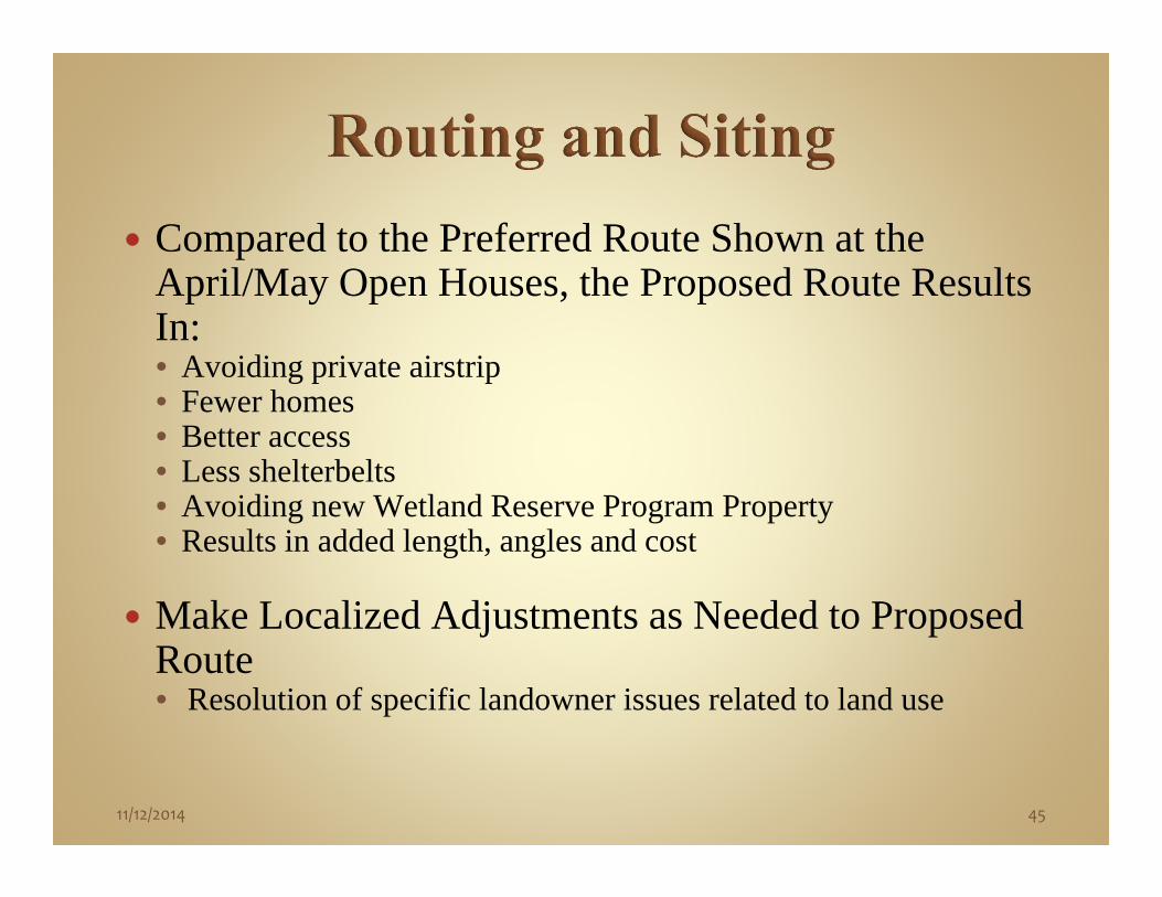
Compared to the Preferred Route Shown at the April/May Open Houses, the Proposed Route Results In:• Avoiding private airstrip• Fewer homes• Better access• Less shelterbelts• Avoiding new Wetland Reserve Program Property• Results in added length, angles and cost
Make Localized Adjustments as Needed to Proposed Route• Resolution of specific landowner issues related to land use
11/12/2014 45
Clint Endsley, PEProject Engineer
POWER Engineers, Inc.

47
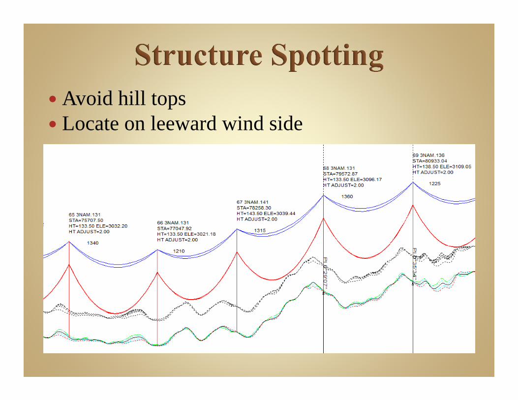
Avoid hill tops Locate on leeward wind side

49
TUBULAR STEEL POLE
HORIZONTAL LATTICE TOWER


51
TUBULAR STEEL POLE
HORIZONTAL LATTICE TOWER

53
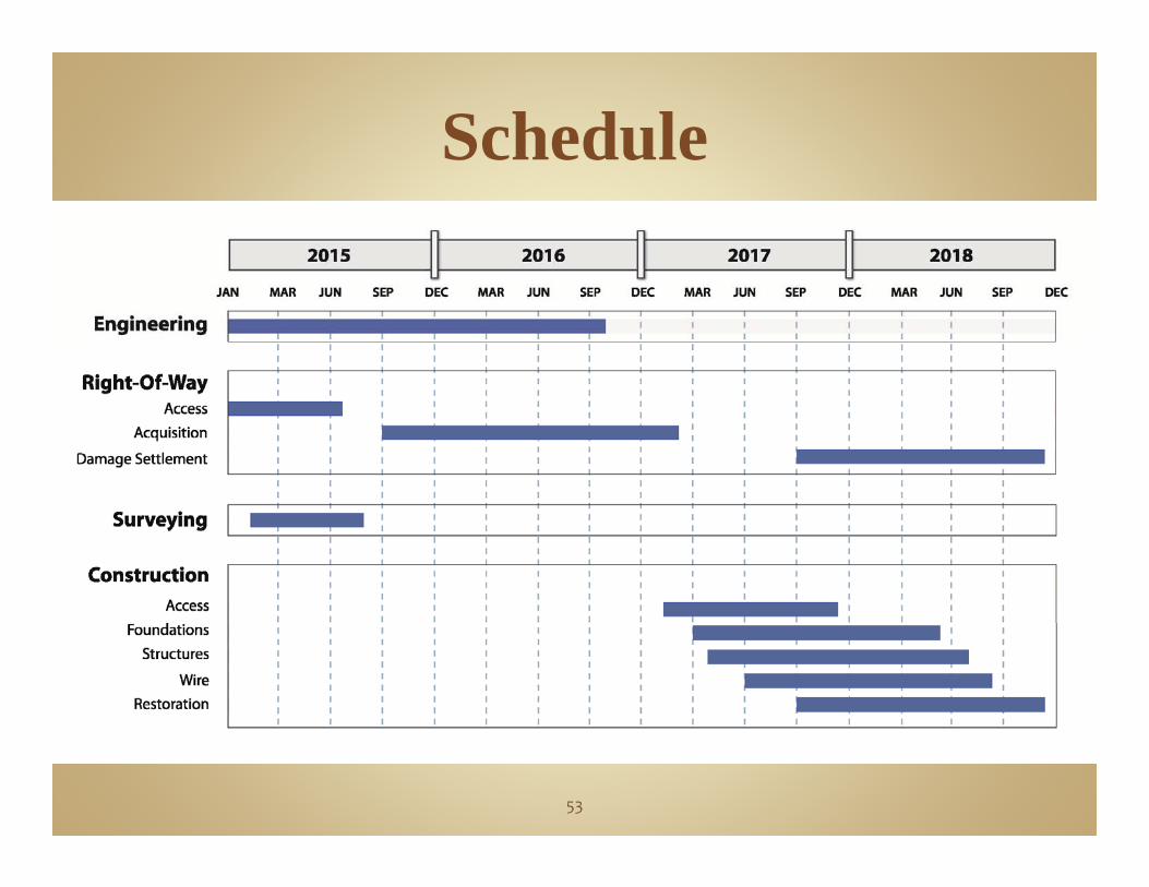
Schedule

54


56

Process of Succession Stabilization Vegetative Cover Periods of Varying Dominant
Plant Communities Native Plant Community Returns
Input from Stakeholders Landowners Sandhills Experts (Dr.
Stubbendieck, Restoration Contractors)
Local Agencies (UNL, NRCS, NRD, NDOR)

Al BeiermannLand Management Manager
Nebraska Public Power District

Stage 1: Preliminary activities• Survey• Engineering• Environmental• Appraisal
Stage 2: Acquisition of easements and substation sites
Stage 3: Construction and Maintenance activities
59
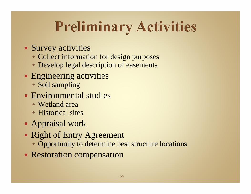
Survey activities• Collect information for design purposes• Develop legal description of easements
Engineering activities• Soil sampling
Environmental studies• Wetland area• Historical sites
Appraisal work Right of Entry Agreement
• Opportunity to determine best structure locations Restoration compensation
60

Landowner Contacts• Description of transmission line and easement• Landowner input welcome
Easement Rights• Landowner rightsContinue existing operationsRestrictions for trees, buildings, altering grade of land, etc.NPPD review of future plans
• NPPD RightsConstruct, operate, maintain line
Substation Facilities61

Good Faith Negotiations
Compensation Methodology
• Establish baseline land market values
Land classifications (based on land use)
Establish values for all land classifications
Obtain Independent Real Estate Appraiser
62
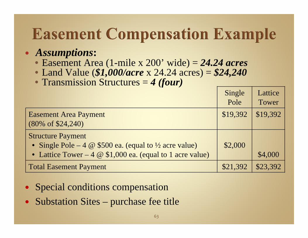
Assumptions: • Easement Area (1-mile x 200’ wide) = 24.24 acres• Land Value ($1,000/acre x 24.24 acres) = $24,240• Transmission Structures = 4 (four)
Special conditions compensation Substation Sites – purchase fee title
SinglePole
Lattice Tower
Easement Area Payment(80% of $24,240)
$19,392 $19,392
Structure Payment• Single Pole – 4 @ $500 ea. (equal to ½ acre value) • Lattice Tower – 4 @ $1,000 ea. (equal to 1 acre value)
$2,000$4,000
Total Easement Payment $21,392 $23,392
63
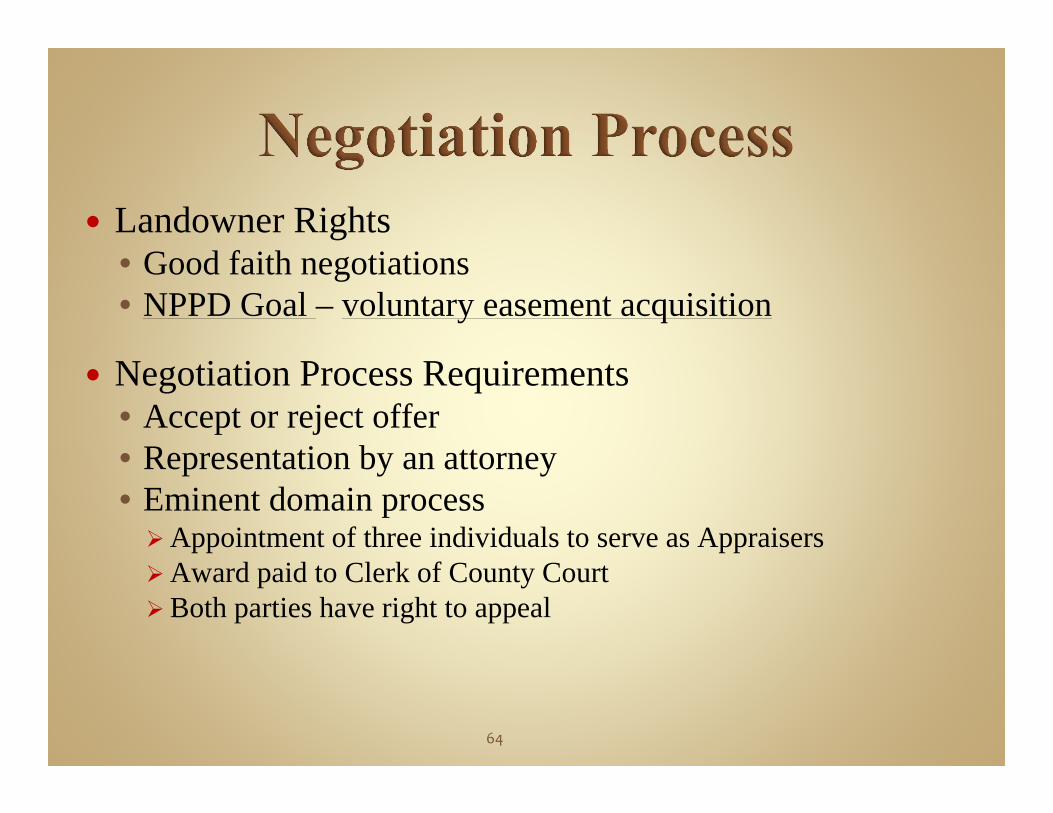
Landowner Rights• Good faith negotiations • NPPD Goal – voluntary easement acquisition
Negotiation Process Requirements• Accept or reject offer• Representation by an attorney• Eminent domain processAppointment of three individuals to serve as AppraisersAward paid to Clerk of County CourtBoth parties have right to appeal
64

Construction Activity• Compensation for damages
Tree Removal• Protect line integrity• Reduce future maintenance activities• Dispose of material
Future Maintenance Activity• Compensation for damages
Thirty-Day Comment Period
65

Tom Kent, Vice President and Chief Operating
Officer