pt geoprima solusi tbk company in brief
TRANSCRIPT
SF SEKURITAS | 1
PT Geoprima Solusi Tbk
IPO Report
SEKURITAS
Executive Summary
Company in Brief:
PT Geoprima Solusi Tbk is an Indonesian company that was
established in 1998 with the distribution, sale, and reparation of
geospatial equipment, mainly land surveying and navigation systems,
as its core business. The company operates as a distributor of South
Instrument, a geospatial equipment manufacturer in China.
HIGHLIGHTS:
• Years of Experience in the Niche Market – The company
has approximately 23 years of experience in the industry. Its
presence in Indonesia’s Geospatial Market is far from being
unnoticed. Over time, the company has built a healthy
relationship with the government and state-owned
enterprises.
• Unprecedented Recent Revenue Growth – The company
has seen extraordinary growth in recent years, excluding
2020 due to the COVID-19 pandemic. Revenue grew 137%
and 61% in 2018 and 2019 respectively. This IPO
transaction will provide the needed resources for the
company to capitalize on its growth momentum.
• Debt-free – The company’s capital structure is composed of
100% equity. Based on the proprietary internal projection,
the company could lever up and improve its ROE with little
impact on its profitability and cash flow.
• Geospatial is More Relevant Than Ever – The ever-
increasing demand for data and ease of aggregating it
through technology cause a spike in the awareness and
implementation of geospatial technology in the commercial
setting.
• Minimal Inherited Default Risk from an Undiversified
Supplier Portfolio – The company is acting as the sole
distributor of South Instrument, a Chinese geospatial
equipment manufacturer, in Indonesia. Although this
suggests that the company captures the complete market
share on the sales of South Instrument’s products, the
company faces an increased risk consideration to factor in
the potential default risk coming from the principal (South
Instrument). That said, the company is under no obligation
to only distribute South Instrument’s products and can
engage other suppliers.
INVESTMENT RATIONALE:
Positive Investment Recommendation – The company is a part of a
low-risk industry with a growing market and relevance that is
integrated into a more saturated and mature industry. Internally, the
company is profitable with a healthy capital structure but adopts a
slight potential default risk from its principal.
PT GEOPRIMA SOLUSI TBK
Ticker GPSO
Target Price Rp 233
Potential Upside 29.17%
Estimated IPO Schedule Book Building 9-13 Agustus 2021
Effective Date 25 August 2021
Offering Period 27 Aug -1 Sept 2021
Listing Date 3 September 2021
Indicative IPO Structure Max Offered Shares 166,666,600
Max Shares Post-IPO 666,666,600
Par Value per Share Rp50.00
Offering Price per Share Rp175 – Rp180
Floating Shares 25%
Listing Indonesia Stock Exchange
Use of Proceeds Mixed-use Building 30.61%
LiDAR (Equipment) 36.74%
UAVs (Inventory) 20.41%
Marketing 12.24%
Forecast Valuation
2021F 2022F
P/E 42.2 x 11.4 x
P/BV 2.83 x 2.5 x
Contributor
Kenedy Anguwono
Shofiyanto [email protected]
Yakobus Yulianto [email protected]
Table of Content Financial Exhibit 2
Geospatial as an Industry 3
Domestic Geospatial Industry 6
Company Overview 9
Financial Breakdowns 11
Valuation 12
Qualitative 14
SF SEKURITAS | 2
PT Geoprima Solusi Tbk
IPO Report
SEKURITAS
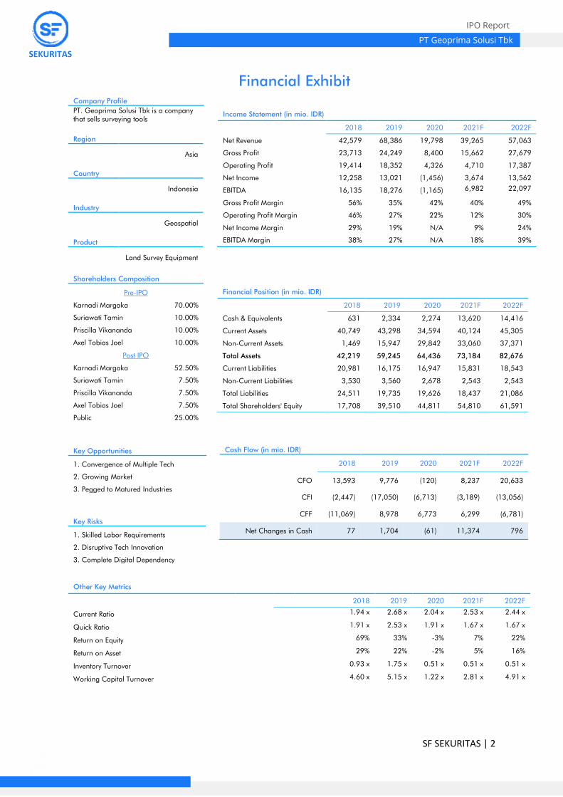
Financial Exhibit
Other Key Metrics
2018 2019 2020 2021F 2022F
Current Ratio 1.94 x 2.68 x 2.04 x 2.53 x 2.44 x
Quick Ratio 1.91 x 2.53 x 1.91 x 1.67 x 1.67 x
Return on Equity 69% 33% -3% 7% 22%
Return on Asset 29% 22% -2% 5% 16%
Inventory Turnover 0.93 x 1.75 x 0.51 x 0.51 x 0.51 x
Working Capital Turnover 4.60 x 5.15 x 1.22 x 2.81 x 4.91 x
Company Profile
PT. Geoprima Solusi Tbk is a company that sells surveying tools
Income Statement (in mio. IDR)
2018 2019 2020 2021F 2022F
Net Revenue 42,579 68,386 19,798 39,265 57,063
Gross Profit 23,713 24,249 8,400 15,662 27,679
Operating Profit 19,414 18,352 4,326 4,710 17,387
Net Income 12,258 13,021 (1,456) 3,674 13,562
EBITDA 16,135 18,276 (1,165) 6,982 22,097
Gross Profit Margin 56% 35% 42% 40% 49%
Operating Profit Margin 46% 27% 22% 12% 30%
Net Income Margin 29% 19% N/A 9% 24%
EBITDA Margin 38% 27% N/A 18% 39%
Financial Position (in mio. IDR)
2018 2019 2020 2021F 2022F
Cash & Equivalents 631 2,334 2,274 13,620 14,416
Current Assets 40,749 43,298 34,594 40,124 45,305
Non-Current Assets 1,469 15,947 29,842 33,060 37,371
Total Assets 42,219 59,245 64,436 73,184 82,676
Current Liabilities 20,981 16,175 16,947 15,831 18,543
Non-Current Liabilities 3,530 3,560 2,678 2,543 2,543
Total Liabilities 24,511 19,735 19,626 18,437 21,086
Total Shareholders' Equity 17,708 39,510 44,811 54,810 61,591
Region
Asia
Country
Indonesia
Industry
Geospatial
Product
Land Survey Equipment
Shareholders Composition
Pre-IPO
Karnadi Margaka 70.00%
Suriawati Tamin 10.00%
Priscilla Vikananda 10.00%
Axel Tobias Joel 10.00%
Post IPO
Karnadi Margaka 52.50%
Suriawati Tamin 7.50%
Priscilla Vikananda 7.50%
Axel Tobias Joel 7.50%
Public 25.00%
Cash Flow (in mio. IDR)
2018 2019 2020 2021F 2022F
CFO 13,593 9,776 (120) 8,237 20,633
CFI (2,447) (17,050) (6,713) (3,189) (13,056)
CFF (11,069) 8,978 6,773 6,299 (6,781)
Net Changes in Cash 77 1,704 (61) 11,374 796
Key Opportunities
1. Convergence of Multiple Tech
2. Growing Market
3. Pegged to Matured Industries
Key Risks
1. Skilled Labor Requirements
2. Disruptive Tech Innovation
3. Complete Digital Dependency

SF SEKURITAS | 3
PT Geoprima Solusi Tbk
IPO Report
SEKURITAS
Geospatial as an Industry
What is Geospatial?
The geospatial industry, fundamentally, has always revolved around
the mapping and surveying of both land and marine. To this day, that
statement remains true. However, through the rapid expansion and
advancement of technology, the geospatial industry evolves into a
much bigger and more complex industry. Geospatial now
encompasses segments such as GIS (Geographic Information System)
/ Spatial Analytics, GNSS (Global Navigation Satellite System), and
Earth Observation (EO). The ever-growing integration of the digital
world, Internet of Things, Artificial Intelligence, Big Data, and robotics
into the geospatial industry and the increasing demand for data and
information further extends the industry’s reach and relevancy towards
other industries.
Ecosystem of the Industry
The current landscape of Geospatial industry and relationships
between segments are increasing in complexity and
interconnectedness. This conditions the industry to be more productive,
efficient, accurate, and safe; thus, bringing more value towards the
global economy and society.
As of now, chains of relationships between segments are as follow:
• Global Navigation Satellite System (GNSS) is highly
dependent and driven by Internet of Things, facilitated by an
interconnected system, and communicated through a
wireless network.
• Geographic Information System is a cloud-based analytic
system facilitated by open data.
• Earth Observation is geared towards professional niche
users that are Big Data and Artificial Intelligence-driven. The
enormous size of data and its volume requires the integration
of the aforementioned drivers alongside open data and the
cloud.
• Scanning Segment relies on Artificial Intelligence and Big
Data to generate high-quality mapping and self-driving cars.
This segment is heavily facilitated by standards.
Geospatial Ecosystem
Source: Geospatial Industry Outlook 2019, Geobuiz
SF SEKURITAS | 4
PT Geoprima Solusi Tbk
IPO Report
SEKURITAS
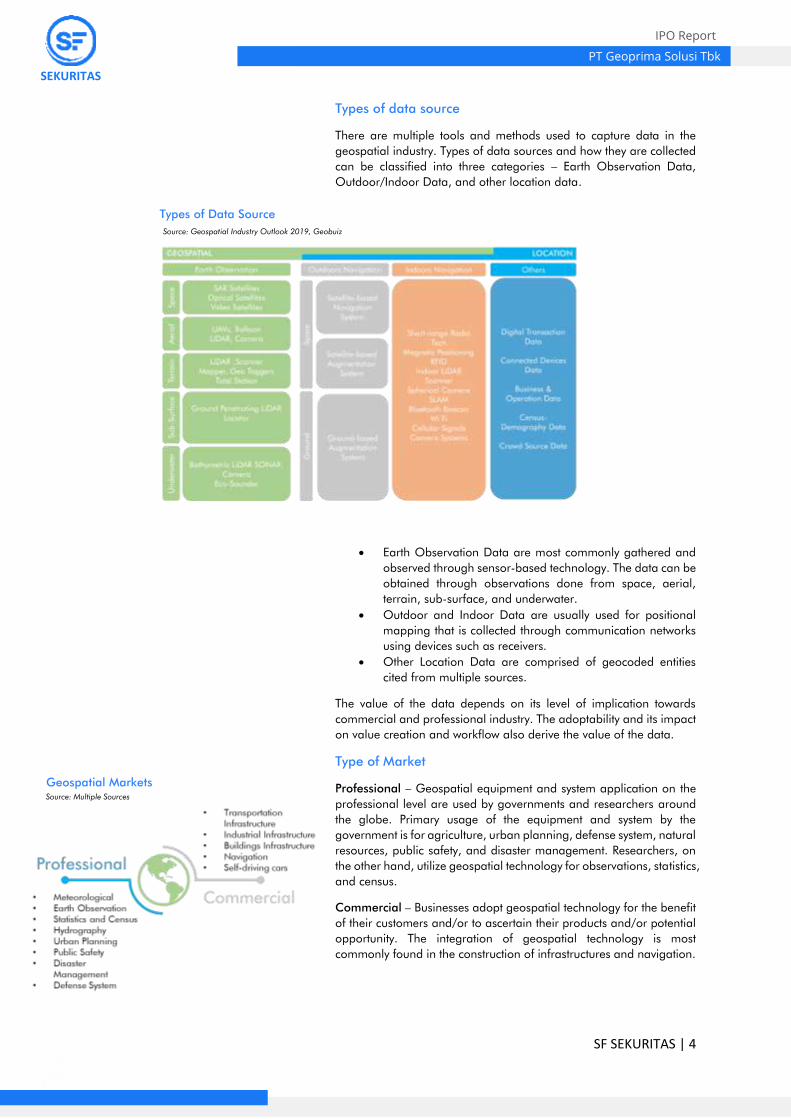
Types of data source
There are multiple tools and methods used to capture data in the
geospatial industry. Types of data sources and how they are collected
can be classified into three categories – Earth Observation Data,
Outdoor/Indoor Data, and other location data.
• Earth Observation Data are most commonly gathered and
observed through sensor-based technology. The data can be
obtained through observations done from space, aerial,
terrain, sub-surface, and underwater.
• Outdoor and Indoor Data are usually used for positional
mapping that is collected through communication networks
using devices such as receivers.
• Other Location Data are comprised of geocoded entities
cited from multiple sources.
The value of the data depends on its level of implication towards
commercial and professional industry. The adoptability and its impact
on value creation and workflow also derive the value of the data.
Type of Market
Professional – Geospatial equipment and system application on the
professional level are used by governments and researchers around
the globe. Primary usage of the equipment and system by the
government is for agriculture, urban planning, defense system, natural
resources, public safety, and disaster management. Researchers, on
the other hand, utilize geospatial technology for observations, statistics,
and census.
Commercial – Businesses adopt geospatial technology for the benefit
of their customers and/or to ascertain their products and/or potential
opportunity. The integration of geospatial technology is most
commonly found in the construction of infrastructures and navigation.
Types of Data Source
Geospatial Markets
Source: Geospatial Industry Outlook 2019, Geobuiz
Source: Multiple Sources

SF SEKURITAS | 5
PT Geoprima Solusi Tbk
IPO Report
SEKURITAS
Outlook of Geospatial in AEC Industry
Geospatial market value towards the AEC (Architecture, Engineering,
and Construction) industry is expected to grow by a CAGR of 13.3%
from 2019 to 2023. This implies the ever-increasing relevance and
importance of geospatial technology in the AEC industry.
The AEC industry, meanwhile, will see more modest growth from 2019
to 2023 with a CAGR of 3.3%. Note that the industry is a matured
industry and such growth is fair and as expected.
Continue to Next Page →
Cumulative Global AEC Market Global Geospatial Market in AEC Industry
1,1
9
1,3 1,4
22,5
8
2,4
8
2,2
9
7,3
6
7,9
4
8,5
5
0
2
4
6
8
10
2019 2021 2023
In trilli
on U
SD
Transportation Industrial Building
US$ 11.13 trillion
CAGR 3.3%
US$ 11.72 trillion US$ 12.26 trillion
71,2878,67
89,68
102,53
117,59
0
20
40
60
80
100
120
140
2019 2020 2021 2022 2023
in b
illio
n U
SD
CAGR 13.3%
Source: GEOBIM market in AEC Industry Report, Geospatial Media Source: GEOBIM market in AEC Industry Report, Geospatial Media

SF SEKURITAS | 6
PT Geoprima Solusi Tbk
IPO Report
SEKURITAS
Domestic Geospatial Market
Key Takeaways
There are four (4) highly prospective segments that geospatial
technology has been and will continue to be an integral part of in
Indonesia – Construction, Agriculture, Mining, and Disaster Mitigation
and Prevention. Through surveying tools and photogrammetry
technology, geospatial industry’s contribution to these four segments
is immense.
1) Indonesia has the fourth-largest population and an infrastructure
that is not adequate to accommodate such a large number of
people. Additionally, the current lack of infrastructure is causing
a bottleneck in the advancement and growth of Indonesia’s
Economy (ifc.org). Based on the GCI 2019, Indonesia is ranked
72nd of 141 economies in terms of infrastructure. These posed a
common urgency for the Indonesian government to push its
investments in infrastructure; along with it, geospatial industry.
2) Indonesia is an agrarian country and is the largest producer of
Crude Palm Oil (CPO) in the world; more than double Malaysia
the second-largest producer. According to Indonesia’s Minister of
Agriculture, 58.9 million hectares of land was allocated to CPO
plantation. Since CPO production is heavily reliant on land,
geospatial technology can provide better information on the
utilization of land in plantations.
3) Indonesia’s adoption of greener energy sources is still far from
realization and the country has an enormous appetite for energy
to fuel its high-octane economy. With an uptrend in domestic coal
production and consumption, an increase in demand for
geospatial equipment to locate potential reserves, comply with
health and safety standards, and improve operational efficiency
is to be expected. 4) It is not uncommon that Indonesia is associated with natural
disasters due to its geological positioning and lack of proper
infrastructure. From January to Mei 2020 alone, Indonesia has
experienced 1,295 natural disasters. These numbers are
dominated by floods, landslides, and tornadoes. The devastating
impact of these natural recurring disasters has raised awareness
to apply a better system for mitigation and prevention, which
requires geospatial equipment.
Construction
In 2018, the government’s infrastructure budget was recorded at
IDR394 trillion. Meanwhile, in 2020, there was a significant decrease
in infrastructure spending due to the Covid-19 pandemic postponing
infrastructure development (APBN Information for 2021, Ministry of
Finance of the Republic of Indonesia).
For 2021, the infrastructure budget spending will be focused on public
health facilities and the provision of basic necessities to support the
national public health system after the Covid-19 pandemic. In
addition, development is also focused on digital infrastructure to drive
logistical efficiency and connectivity. Completion of pending 2020
priority activities is also the focus of the government in its infrastructure
policy in 2021.
Indonesia’s Gov’ Infrastructure Budget
-40%
-30%
-20%
-10%
0%
10%
20%
30%
40%
50%
60%
0
50
100
150
200
250
300
350
400
450
2016 2017 2018 2019 2020 2021*
in trilli
on r
upia
h
Budget (in trillion Rp) Growth*Outlook
Source: APBN Information 2021, Ministry of Finance R.I.
SF SEKURITAS | 7
PT Geoprima Solusi Tbk
IPO Report
SEKURITAS
Agriculture
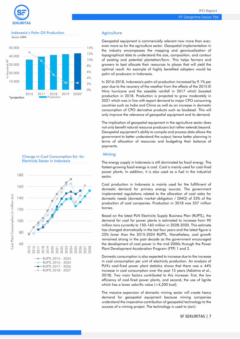
Geospatial equipment is commercially relevant now more than ever;
even more so for the agriculture sector. Geospatial implementation in
the industry encompasses the mapping and geovisualization of
topographical data to understand the size, composition, and contour
of existing and potential plantation/farm. This helps farmers and
growers to best allocate their resources to places that will yield the
optimal result. An example of highly benefited adopters would be
palm oil producers in Indonesia.
In 2016-2018, Indonesia's palm oil production increased by 9.1% per
year due to the recovery of the weather from the effects of the 2015 El
Nino hurricane and the sizeable rainfall in 2017 which boosted
production in 2018. Production is projected to grow moderately in
2021 which was in line with export demand to major CPO consuming
countries such as India and China as well as an increase in domestic
consumption of CPO derivative products such as biodiesel. This will
only improve the relevance of geospatial equipment and its demand.
The implication of geospatial equipment in the agriculture sector does
not only benefit natural resource producers but rather extends beyond.
Geospatial equipment’s ability to compile and process data allows the
government to better understand the output; hence better planning in
terms of allocation of resources and budgeting their balance of
payments.
Mining
The energy supply in Indonesia is still dominated by fossil energy. The
fastest-growing fossil energy is coal. Coal is mainly used for coal-fired
power plants. In addition, it is also used as a fuel in the industrial
sector.
Coal production in Indonesia is mainly used for the fulfillment of
domestic demand for primary energy sources. The government
implemented regulations related to the allocation of coal sales for
domestic needs (domestic market obligation / DMO) of 25% of the
production of coal companies. Production in 2018 was 557 million
tonnes.
Based on the latest PLN Electricity Supply Business Plan (RUPTL), the
demand for coal for power plants is estimated to increase from 90
million tons currently to 150-160 million in 2028-2030. This estimate
has changed dramatically in the last four years and the latest figure is
25% lower than the 2015-2024 RUPTL. Nonetheless, coal growth
remained strong in the past decade as the government encouraged
the development of coal power in the mid-2000s through the Power
Plant Development Acceleration Program (FTP) 1 and 2.
Domestic consumption is also expected to increase due to the increase
in coal consumption per unit of electricity production. An analysis of
PLN's coal-fired power plant statistics shows that there was a 44%
increase in coal consumption over the past 15 years (Adiatma et al.,
2018). Two main factors contributed to this increase: first, the low
efficiency of coal-fired power plants, and second, the use of lignite
which has a lower calorific value (<4,200 kcal).
The massive expansion of domestic mining sector will create heavy
demand for geospatial equipment because mining companies
understand the imperative contribution of geospatial technology to the
success of a mining project. The technology is used to (esri):
Indonesia’s Palm Oil Production
Change in Coal Consumption Est. for
Electricity Sector in Indonesia
0%
2%
4%
6%
8%
10%
12%
14%
-
10.000
20.000
30.000
40.000
50.000
2016 2017 2018 2019 2020*
in thousa
nd M
T
Production*projection
Source: USDA
60
80
100
120
140
160
180
20
15
20
16
20
17
20
18
20
19
20
20
20
21
20
22
20
23
20
24
20
25
20
26
20
27
20
28
Coal Pla
nt C
onsu
mptio
n (in
mill
ion ton)
RUPTL 2015 - 2024RUPTL 2016 - 2025RUPTL 2017 - 2026RUPTL 2018 - 2027

SF SEKURITAS | 8
PT Geoprima Solusi Tbk
IPO Report
SEKURITAS
• Target mineral exploration
• Evaluate mining conditions
• Model mine construction
• Display geochemical and hydrology data
• Improve facility management and policing
• Apply for mining permits
• Assess environmental impact
• Manage land titles
• Process closures
• Plan reclamation activities
• Improve community education
Disaster Mitigation
In 2020, Indonesia has experienced 2,951 natural disasters. These
numbers are dominated by flood, landslide, and tornado. The natural
disasters caused 6,450,903 refugees, 409 death cases, and 536
injured victims. Aside of natural disasters, as of 13 April 2020 the
government assigned Covid-19 spread-out as non-natural national
disaster.
The devastating impact of these natural recurring disasters has raised
awareness to apply a better system for mitigation and prevention,
which requires geospatial equipment.
The Disaster Management Cycle and the geospatial technology
implication are (BNPB):
1. Planning and Mitigation – geospatial technology can be used
to pinpoint hazardous location and quickly evaluate the risk
of potential emergencies.
2. Preparation – Geospatial equipment constantly monitors
signs and early warnings of emergency events in real-time.
3. Event – the occurrence of emergencies or disasters.
4. Response – Geospatial data helps decisionmakers to
understand the damages and resources required.
5. Recovery – Geospatial technology and data can display and
monitor an area’s recovery phases. The technology also
helps in creating a long-term recovery plan.
Continue to Next Page →

SF SEKURITAS | 9
PT Geoprima Solusi Tbk
IPO Report
SEKURITAS
Company Overview
Company Background
PT Geoprima Solusi Tbk is an Indonesian company that was
established in 1998 with the distribution, sale, and reparation of
geospatial equipment, mainly land surveying and navigation systems,
as its core business. The company operates as a sole distributor of
South Instrument, a geospatial equipment manufacturer.
Management Biography
Shareholders Structure
Axel Tobias Joel
President Commissioner
22 Years Old
5 Years of Experience
Bachelor Degree from City University
of Seattle (in progress)
Priscilla Vikananda Margaka
Commissioner
27 Years Old
8 Years of Experience
MBA from City University of Seattle
Pardjo
Independent Commissioner
44 Years Old
27 Years of Experience
MBA from Atma Jaya Jakarta
Suriawati Tamin
Director of Finance
54 Years Old
35 Years of Experience
Bachelor Degree from Christian
University of Indonesia
Karnadi Margaka
President Director
54 Years Old
32 Years of Experience
MBA from School of Theology LETS
Daniel Gunawan
Director of Operation
43 Years Old
21 Years of Experience
Bachelor Degree from Sekolah
Tinggi Theologia Reformed Injili
Indonesia

SF SEKURITAS | 10
PT Geoprima Solusi Tbk
IPO Report
SEKURITAS
Business Model
PT Geoprima Solusi Tbk has three (3) main operations – Sales of
Product, Consultation, and Reparation.
Sales of Products workflow is as follows:
1. Client submits a purchase order
2. The company checks availability through its inventory
management system
3. In the event that the product is not on hand, the company will
send a delivery request from its principal
4. Principal delivers the requested product to the warehouse
5. The company procures the product from the warehouse
6. The company completes the client’s purchase order
Consultation workflow is as follows:
1. Client requests a consultation service
2. The company refers to its principal’s products
3. The company provides consultation service to the client
Reparation workflow is as follows:
1. Client submits a reparation request
2. The company checks the availability of repair parts through
its inventory management system
3. In the event that the required repair part is not on hand, the
company will send a delivery request from its principal
4. Principal delivers the requested repair part to the warehouse
5. The company procures the repair part from the warehouse
6. The company repairs the client’s product.
Product
• PT Geoprima Solusi Tbk is the certified distributor of South
Instrument. The products that the company offers are as
follow:
• Global Positioning System (GPS) – navigation system that
utilizes satellites, receivers, and algorithms to pinpoint
locations
• Electronic Total Station – a tool to measure angles and
distances electronically and outputs position coordinates.
• Echo Sounder – a tool to map out the ocean floor by
transmitting sound waves and pulses.
• LiDAR – a mapping tool that uses pulsating lasers to create
a high-resolution model.
• Theodolites – a tool to measure horizontal and vertical
angles.
Clients
Most of PT Geoprima Solusi Tbk's clients are State-owned Enterprises
and government entities such as but not limited to PT Wijaya Karya
Beton Tbk, Ministry of Agrarian Affrairs and Spatial Planning, and
Ministry of Energy and Mineral Resources.

SF SEKURITAS | 11
PT Geoprima Solusi Tbk
IPO Report
SEKURITAS
Financial Breakdown
Revenue
The Company was adversely impacted by the economic contraction
caused by the COVID-19 pandemic. Its revenue dropped by 71% YoY.
The company plans to reach beyond its previous peak by 2023.
Moving forward beyond 2021, they are expecting a significant level of
growth by capitalizing on its pre-pandemic momentum. The IPO
proceeds are essential for the company to capture Indonesia’s
domestic market and secure its targeted growth rate.
The major contributor to PT Geoprima Solusi Tbk’s revenue is the sale
of GPS. It accounts for around 90% of Total Revenue. Most of the GPS
sale was Tender-based; however, the company hopes to see equal
contribution from tender and non-tender in the future. The company
expects a more diversified sale of products with the addition of UAVs
and LiDARs.
Gross Earnings
PT Geoprima Solusi Tbk has a thick gross profit margin, around 44%
historically. This statement will remain true for the foreseeable future
based on internal projection. This is could be accredited to the
company’s favorable terms with both the supplier and customers.
EBITDA
Ever since 2018, the company manages to have a sizeable EBITDA
margin. This potentially suggests that the management has been
effective in controlling cost centers. The drop in EBITDA margin in
2021 to a negative level is due to a drop in sales performance and a
non-recurring IPO fee of Rp 5.5 billion.
Net Earnings
PT Geoprima Solusi Tbk has enjoyed outstanding Net Earnings since
2018. The company’s lack of financing expenses adds to this fact.
With an average of 17% Net Earnings Margin historically and
expectation of reaching 24% before diminishing to account for
potential rising competition, the company has prepared a thick buffer
for unexpected costs. This might open up an opportunity to lever up
the company and improve its Return of Equity.
In Billion IDR
In Billion IDR
In Billion IDR
In Billion IDR
18
43
68
20
39
57
78 89
102
-100%
-50%
0%
50%
100%
150%
-
20
40
60
80
100
120
Revenue growth
7
24 24
8 16
28
42 48
56
0%
10%
20%
30%
40%
50%
60%
-
10
20
30
40
50
60
Gross Earning Margin
1
1618
-1
7
22
32 32 31
-10%
0%
10%
20%
30%
40%
50%
-505
101520253035
EBITDA Margin
-10%
0%
10%
20%
30%
40%
-5
0
5
10
15
20
25
Net Earning Margin

SF SEKURITAS | 12
PT Geoprima Solusi Tbk
IPO Report
SEKURITAS
Valuation
Valuation Summary
Based on the consolidation of two approaches, income approach
using FCFE method and market approach using PBV multiple method,
the equity value ranges from Rp 209 to Rp 256 per share.
Rationale
FCFE
1) FCFE has the closest approximation on the theoretical value of
the company’s ability to generate cash flow from the perspective
of equity holders.
2) FCFE accounts for the associated systemic risk.
3) FCFE is a standardized valuation method most commonly used
by institutions.
PBV Multiple
1) Generally, relative valuation represents real market conditions
and sentiment toward the pricing of comparable companies.
2) Relative valuation is equally common and most pragmatic in most
cases.
3) Book value is more stable than EPS and is positive in most cases;
even when EPS is negative.
Income Approach
Based on the Free Cash Flow to Equity method, the fair value of the
company’s equity is to be around Rp 159 billion. This valuation is
derived using 12.38% WACC which accounts for IBPA 30Y Notes’
yield, developing country risk spread, and Blume adjusted sectoral
Beta. Additionally, 22% tax rate and 3.5% perpetual growth rate were
used and believed to be fair assumptions.
(50.000)
50.000
100.000
150.000
200.000
2021 2022 2023 2024 2025 2026 2027 2028 2029 2030
Net Revenue CAPEX FCFE Cash Balance

SF SEKURITAS | 13
PT Geoprima Solusi Tbk
IPO Report
SEKURITAS
Market Approach
With the lack of commonly sized domestic players, the relative
valuation takes on a broader perspective, adjusts by discounting the
weight, and selects several notable global players such as Nearmap
Ltd., Beijing Supermap Software, Topcon Corp, Scanpoint Geomatic
Ltd., and Boustead Singapore Ltd. The multiple used were PBV and
Price-to-Sales. The fair value of the company based on relative
valuation is around Rp 148 billion.
Consolidation
The equity value based on 2 approach is as follows:
t 1 2 3 4 5 6 7 8 9 10 10< Year 2021 2022 2023 2024 2025 2026 2027 2028 2029 2030 Terminal
Fractional 0.48 1.00 1.00 1.00 1.00 1.00 1.00 1.00 1.00 1.00 1.00
(in million IDR) Net Income 3,674 13,562 19,065 18,892 18,598 22,819 22,848 17,258 22,393 27,519
Depreciation 2,272 4,710 7,151 7,529 7,551 7,487 7,397 7,338 9,121 10,455
Δ NWC 2,291 2,361 (4,880) (5,856) 7,693 1,796 (6,200) (3,640) (2,960) (3,694)
Net Debt
Net Capex
(17,379)
(14,146)
(14,146)
(3,396)
(1,396)
(9,896)
(9,896)
(9,896)
(9,896)
(9,896)
FCFE (9,142) 6,486 7,189 17,169 32,445 22,206 14,149 11,060 18,658 24,384 284,300
PV of Equity (8,136) 5,136 5,066 10,765 18,104 11,026 6,251 4,348 6,528 7,592 88,511
Transactional (3,901) 5,136 5,066 10,795 18,104 11,026 6,251 4,360 6,528 7,592 88,511
Total Equity
Value
159,468
Company Name Ticker Currency Price Stock Exchange PBV PE P/S
Nearmap, Ltd NEA AUD 1.88 Australia Stock Exchange 7.92 n/a 11.05
Boustead Singapore Ltd BTSS SGD 1.01 Singapore Stock Exchange 1.39 12.37 0.7
Topcon Corp 7732 JPY 1548 Tokyo Stock Exchange 2.53 n/a 1.23
Beijing Supermap Software 300036 CNY 15.86 Shenzhen Stock Exchange 3.32 30.88 4.33
Scanpoint Geomatics Ltd SCAG INR 16.5 Bombay Stock Exchange 1.39 44.68 1.59
Average
3.31 29.31 3.78
Reconciliation Full Value Weighted Weighted Average Value
Market Approach 148,323 40% 59,329
Income Approach 159,468 60% 95,681
Total Weighted Average Value 155,101
Value per Share (in IDR) 233
263,12
532,35
215,28
65,20
233
-
100
200
300
400
500
600
DCF PBV Comparables Valuation

SF SEKURITAS | 14
PT Geoprima Solusi Tbk
IPO Report
SEKURITAS
Qualitative
Porter five-forces Analysis
Bargaining Power of Suppliers – The Company’s supplier has
moderate bargaining power. Several notable geospatial equipment
manufacturers have a higher global presence in terms of branding;
however, they may not be able to offer better terms of contract
compared to South Instrument.
Bargaining Power of Buyers – Although geospatial takes up a small
portion of Indonesia’s four extensive markets (Mining, Construction,
Agriculture, & Disaster Mitigation), it is invaluable to these industries
because of its contribution to safety and productivity. This translates to
a low bargaining power for the buyers.
Threat of Substitutes – Current geospatial equipment is unique, state
of the art, and specific in terms of usage. Therefore, there is close to
no threat of substitutes.
Threat of New Entrants – The only special requirement to become a
distributor is to hire skilled personnel with technical capabilities and
knowledge to operate, the threat of new entrants is relatively high.
Existing Rivalry – Globally, the geospatial market can be categorized
as monopolistic with each brand offering some type of differentiation.
In Indonesia, on the other hand, the existing rivalry is less prominent
due to the lack of players.
SWOT Analysis
Strength
• A seasoned player in the industry (23 years of experience)
• Competitive Pricing
Weakness
• Product from China may be associated with negative
connotations and manufacturers with a high global presence are
usually from Europe and the USA.
• Currently, the Company is only distributing products from a single
brand.
Opportunity
• Technological innovation creates access to new markets like
disaster mitigation and prevention.
• Increasing demand due to an increase in mining exploration for
commodities with high global usage such as nickel, coal, etc.
Threat
• Relatively low barrier of entry
• High margin will attract new competitors.
1
2
3
4
5Supplier
Buyers
ExistingSubsitution
New Entrant
Scale (1 = unfavorable; 5 = favorable)
0
1
2
3
4
5Strength
Weakness
Opportunity
Threat
Scale (1 = unfavorable; 5 = favorable)
SF SEKURITAS | 15
PT Geoprima Solusi Tbk
IPO Report
SEKURITAS
Disclaimer
This report has been prepared by PT Surya Fajar Sekuritas (“SF Sekuritas”) on behalf of itself and its affiliated
companies and is provided for information purposes only. Under no circumstances is it to be used or considered as
an offer to sell, or a solicitation of any offer to buy. This report has been produced independently and the forecasts,
opinions, and expectations contained herein are entirely those of SF Sekuritas.
While all reasonable care has been taken to ensure that information contained herein is not untrue or misleading at
the time of publication. SF Sekuritas makes no representation as to its accuracy or completeness and it should not
be relied upon as such. This report is provided solely for the information of clients of SF Sekuritas who are expected
to make their own investment decisions without reliance on this report. Neither SF Sekuritas nor any officer or
employee of SF Sekuritas accept any liability whatsoever for any direct or consequential loss arising from any use of
this report or its contents. SF Sekuritas and/or persons connected with it may have acted upon or used the information
herein contained, or the research or analysis on which it is based, before publication. SF Sekuritas may in the future
participate in an offering of the company’s equity securities.
This report was prepared, approved, published, and distributed by SF Sekuritas located outside of the United States
(a “non-US Group Company”). Neither the report nor any analyst who prepared or approved the report is subject
to U.S. legal requirements of the Financial Industry Regulatory Authority, Inc. (“FINRA”) or other regulatory
requirements about research reports or research analysts. No non-US Group Company is registered as a broker-
dealer under the Exchange Act or is a member of the Financial Industry Regulatory Authority, Inc. or any other U.S.
self-regulatory organization.
SF Sekuritas states that it had an investment banking relationship with PT Geoprima Solusi Tbk in the last 12 months.
It expects to receive or intends to seek compensation for investment banking services from PT Geoprima Solusi Tbk
in the next 3 months.
This document is confidential and is being furnished to you solely for your information and may not be reproduced
or redistributed or passed on directly or indirectly, to any other person or published. In whole or in part, for any
purpose. In particular, neither this document nor any copy may be distributed to the press or other media. By
accepting this document, you agree to be bound by the foregoing limitations.