prospectus mining district: whitehorse confidential x …
TRANSCRIPT
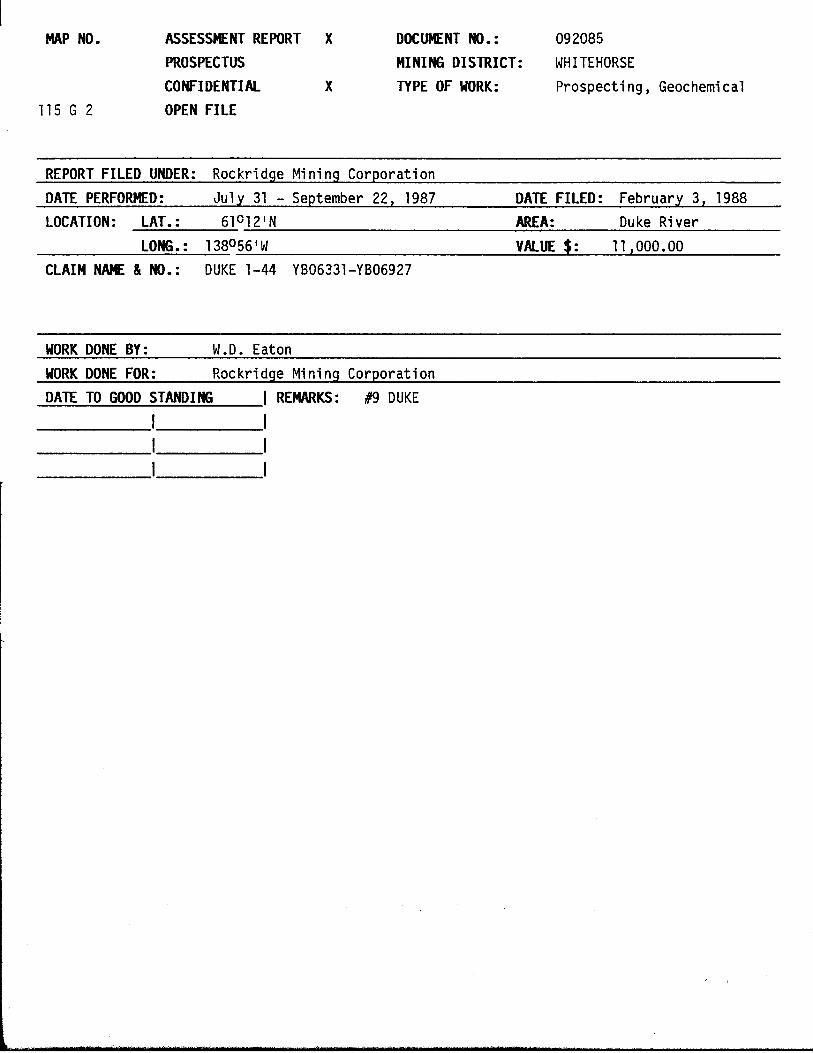
MAP NO. ASSESSMENT REPORT X
PROSPECTUS
CONFIDENTIAL X
OPEN F I L E
DOCUENT NO.: 092085
MINING DISTRICT: WHITEHORSE
TYPE OF WORK: Prospect ing , Geochemical
REPORT FILED UNDER: Rockridge Min ing Corporat ion
DATE PERFORMED: J u l y 31 - September 22, 1987 DATE FILED: February 3, 1988
LOCATION: LAT. : 61012'N AREA: Duke R iver
LONG.: 138056'W VALUE$: 11,000.00
CLAIM NNE & NO.: DUKE 1-44 YB06331-YB06927
WORK DONE BY: W.D. Eaton
WORK DONE FOR: Rockr i dqe Min ing Corporat ion
DATE TO GOOD STANDING 1 REMARKS: #9 DUKE

ARCHER. CATHRO s ABBOCUTEB (leal) LIMITED
CONSULTING GEOLOGICAL E N G I N E E R S
Report On
PROSPECTING AND GEOCHEMICAL PROGRAM
DUKE 1-16 CLAIMS (YB06331-YB06346)
DUKE 17-24 CLAIMS (YB06904-YB06911)
DUKE 25-28 CLAIMS (YB06347-YB06350)
DUKE 29-44 CLAIMS (YB06912-YB06927)
NTS 115G/2
L a t i t u d e 61°12'N; Longi tude 138O56'W
W.D. Eaton, B.A., B.Sc.
December, 1987
Work done between July 3 1 and September 22, 1987

This r e p ~ r t has been exafi ; i ied by the ~eo log i ca l Evaluation Unit under Section 53 (4) Yukon Quartz Mining Act and is allowed as representation work in the amount
3f $ ( 1 r n t -

TABLE OF CONTENTS
.INTRODUCTION ................................................ PROPERTY, LOCATION AND ACCESS ............................... GEOLOGY ..................................................... MINERALIZATION .............................................. GEOCHEMISTRY ................................................ DISCUSSION AND CONCLUSIONS ..................................
NO. - 1
2
3
4
FIGURES
Location Map ........................................ Geology, Mineralization and Claim Data .............. Cu and Ni Geochemistry .............................. Pt, Pd and Au Geochemistry ..........................
APPENDICES
I Author's Statement of Qualifications
I1 Personnel
PAGE - 1
2
3
5
6
8
LOCATION
Following Page 1
In Pocket
In Pocket
In Pocket

INTRODUCTION
Twenty Duke claims were staked on July 22, 1987 by Kluane Joint Venture
(Chevron Minerals Limited and All-North Resources Ltd.) following release of
Geological Survey of Canada (GSC) Reconnaissance Stream Sediment Sampling Open
File 1362 to cover a drainage from which a sample returned strongly anomalous
nickel (791 ppm), copper (254 ppm), and cobalt (74 ppm) values. The nickel and
cobalt values are higher and copper just slightly lower than those obtained by
the GSC from a sample taken directly downstream from the main zone at the
former Wellgreen nickel-copper-cobalt-platinum group element (PGE) Mine, 28 km
to the northwest (see Figure 1 on the following page). The property was
optioned to Rockridge Mining Corporation which subsequently added another
twenty-four claims.
The 1987 exploration program was funded by Rockridge under the author's
supervision and consisted of prospecting and soil geochemistry done during the . second phase of staking and on two days in September. Further attempts to
explore the property were terminated by snow. The Author's Statement of
Qualifications is in Appendix I, while a list of personnel who worked on the
property appears in Appendix 11.

Fisure 1 ARCtER. CATHRO & ASSOCUES (1981) LUTT;ED
LOCATION MAP
'DUKE PROPERTY 0 SO miles - ROCKRIDGE MINING CORPORATION
KLUANE JOINT VENTURE n 6 ? n +'

PROPERTY, LOCATION AND ACCESS
The Duke property consists of forty-four contiguous claims registered with
the Whitehorse Mining Recorder as follows:
Claim Name Grant Numbers Expiry Date
Duke 1-16 Duke 17-24 Duke 25-28 Duke 29-44
YB06331-YB06346 July 28, 1988 YBO6904-YBO6911 August 6, 1988 YB06347-YB06350 July 28, 1988 YB06912-YB06927 August 6, 1988
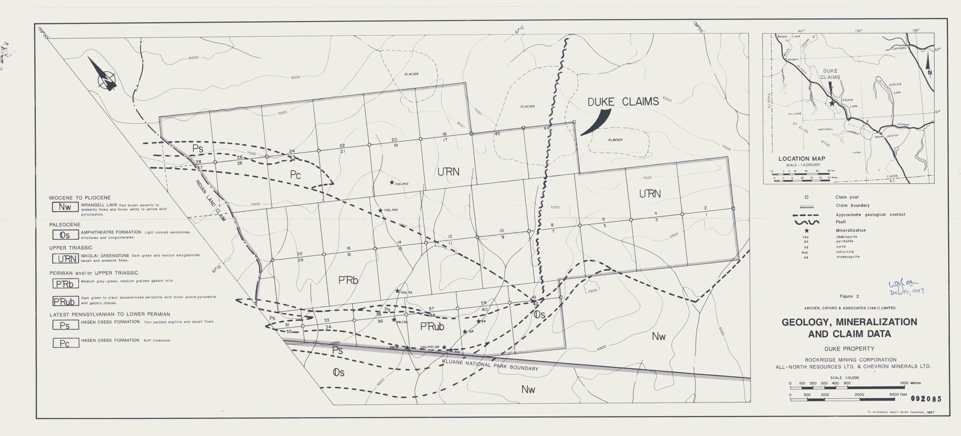
The claims are located at latitude 61°12'N and longitude 138O56'W on NTS
map sheet 115G/2, as shown on Figure 2 in the pocket. The southern and western
property boundaries adjoin Kluane National Park and an Indian Land Claim,
respectively, both of which are closed to mineral exploration at the present
time.
The closest road access lies 9 km to the northeast at Destruction Bay, a
. small community on the paved Alaska Highway, 261 km by road from Whitehorse and
354 km from the year-round, deep-sea port at Haines, Alaska. Access in 1987
was by Bell 2060 helicopter operating from a seasonal base at Burwash Landing,
13 km north of the property.

GEOLOGY
The property is located in the front range of the Kluane Mountains and
covers most of two, south-facing drainages that flow into the Duke River. Both
drainages were occupied by glaciers until recently and have near vertical
cirques at their heads, steep talus slopes on their flanks, and thick deposits
of glacial till on their floors. Outcrop is limited to the cirque faces, ridge
tops and actively eroding creek cuts. Local elevations range from 1700 m in
the creek bottoms to 2250 m on the ridge tops. Vegetation is restricted to
scattered clumps of slide alder in the creek bottoms plus grasses, moss and
lichen on glacial terraces and lower slopes.
Regional mapping by the GSC (Open File 829) indicates that the property
lies within the Wrangellia Terrane and covers a package of sedimentary and
volcanic rocks, the lower part of which is intruded by mafic and ultramafic
sills, as shown on Figure 2. The oldest rocks belong to the Late Pennsylvanian
to Lower Permian Hasen Creek Formation and include thin-bedded argillite and
basalt flows (Unit Ps) and buff limestones (Unit PC). These units are
unconformably overlain to the north and east by dark green and maroon
amygdaloidal basaltic and andesitic flows of the Upper Triassic Nikolai
Greenstone (Unit U K N ) and to the south by a Tertiary sequence that is floored
by Amphitheatre Formation, light coloured sandstones and conglomerates (Unit
0s) and capped by Wrangell Lava, red brown basaltic to andesitic flows with
minor white to yellow acid pyroclastic horizons (Unit NW).
The Hasen Creek Formation rocks are intruded by a complex, Permian to
Upper Triassic sill consisting of a basal ultramafic unit and overlying mafic
unit. The ultramafic (Unit PAub ) is principally comprised of dark green to

black, partially serpentinized peridotite with minor dunite, pyroxenite and
gabbro phases. It is about 270 m thick, strikes northwesterly and dips 60°NE
away from the park boundary. Sedimentary rocks adjacent to the ultramafics
commonly exhibit moderate to intense quartz-carbonate alteration. The mafic
part of the sill (Unit P X b ) is more homogeneous and is primarily medium grey
to green, equigranular, medium-grained gabbro. It appears to be about 500
metres thick and parallels the ultramafic unit. To the east the intrusive
units extend beneath the younger volcanic and sedimentary cap while to the west
(in the Indian Land Claim area) the sill continues with the ultramafic portion
becoming thicker and the mafic portion pinching out.

MINERALIZATION
Six types of mineralization have been identified on the property with the
limited work done to date. Five occur within or adjacent to the ultramafic
sill while the other is hosted by Unit P R b gabbro, as shown on Figure 2 and
described below.
The most abundant mineralization is minor (1 to 2%) pyrrhotite with rare
chalcopyrite and malachite which are finely disseminated throughout the
peridotite and pyroxenite phases of the ultramafic.
Malachite, chalcopyrite (4%) and pyrrhotite (2%) were found in two Unit
Pfi ub gabbro f 1 oat boulders a1 ong the recessive weathering, footwall
contact of the sill.
A lens of massive pyrrhotite, up to 1 m wide, is partially exposed at the
base of a creek cut within intensely quartz-carbonate altered sedimentary
rocks, 50 m below the footwall contact of the sill.
Disseminated arsenopyrite forms up to 5% of some quartz-carbonate altered
rocks lying between the massive pyrrhotite lens and the sill.
Scattered malachite is found on fractures cutting weakly skarnified Unit
Ps sedimentary and volcanic rocks in the footwall of the sill.
Malachite and chalcopyrite occur on fractures and as disseminations in a
few widely scattered, Unit PRb gabbro float boulders.
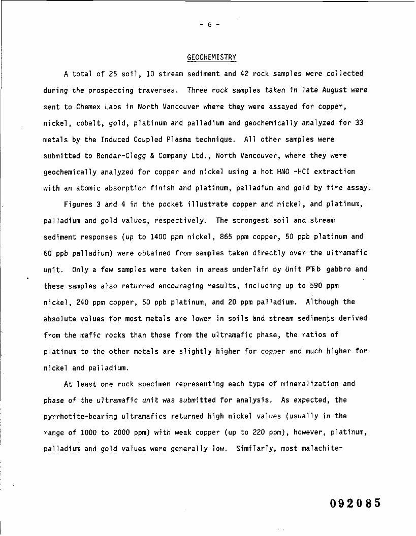
GEOCHEMISTRY
A total of 25 soi 1 , 10 stream sediment and 42
during the prospecting traverses. Three rock samp
rock samples were
les taken in late
coll ected
August were
sent to Chemex Labs in North Vancouver where they were assayed for copper,
nickel, cobalt, gold, platinum and palladium and geochemically analyzed for 33
metals by the Induced Coupled Plasma technique. All other samples were
submitted to Bondar-Clegg & Company Ltd., North Vancouver, where they were
geochemically analyzed for copper and nickel using a hot HNO -HCI extraction
with an atomic absorption finish and platinum, palladium and gold by fire assay.
Figures 3 and 4 in the pocket illustrate copper and nickel, and platinum,
palladium and gold values, respectively. The strongest soil and stream
sediment responses (up to 1400 pprn nickel, 865 pprn copper, 50 ppb platinum and
60 ppb palladium) were obtained from samples taken directly over the ultramafic
unit. Only a few samples were taken in areas underlain by Unit PRb gabbro and . these samples also returned encouraging results, including up to 590 pprn
nickel, 240 pprn copper, 50 ppb platinum, and 20 pprn palladium. Although the
absolute values for most metals are lower in soils and stream sediments derived
from the mafic rocks than those from the ultramafic phase, the ratios of
platinum to the other metals are slightly higher for copper and much higher for
nickel and palladium.
At least one rock specimen representing each type of mineralization and
phase of the ultramafic unit was submitted for analysis. As expected, the
pyrrhotite-bearing ultramafics returned high nickel values (usually in the
range of 1000 to 2000 ppm) with weak copper (up to 220 ppm), however, platinum,
palladium and gold values were generally low. Similarly, most malachite-

and/or chalcopyrite-bearing rocks produced moderate to high copper assays (up
to 2.6%) but only background to weakly anomalous values for the other metals.
The only sample that returned potentially economic grade assays (2.04% copper,
0.74% nickel, 420 ppb platinum and 1380 ppb palladium) was taken from one of
the malachite-, chalcopyrite- and pyrrhotite-bearing, Unit PXub gabbro float
boulders found along the recessive weathering footwall contact. Surprisingly,
a chip sample across the massive pyrrhotite lens on specimens of the
arsenopyrite-bearing quartz-carbonate yielded near background values for all
metals.

DISCUSSION AND CONCLUSIONS
Preliminary prospecting and geochemical results are encouraging, having
located several previously unreported mineral occurrences associated with mafic
and ultramafic rocks similar to those that host nickel-copper-cobalt-PGE
mineralization at the former Wellgreen Mine. The results are further enhanced
by the presence of moderate to strong soil geochemical anomalies.
Based on initial prospecting, the most favourable target appears to be the
recessive weathering footwall contact, but it should be remembered that only a
tiny fraction of the area of interest has been explored and that almost no work
has been done on the Unit PKb gabbro where soil geochemistry suggests platinum
is concentrated relative to other
The total thickness of the s
ultramafic units, is about 750 m y
Wellgreen district. Although the
metals.
i l l on the Duke property, including mafic and
which makes it one of the thickest in the
strike extension to the northwest cannot be .
explored because of an Indian Land Claim, the sill is open to the southeast
where it projects beneath younger cover rocks. The main obstacles to future
exploration are the lack of direct access, the proximity to the park boundary
and the glacial till that obscures most of the ultramafic rocks.
This property covers one of the prime targets in the Wellgreen area and
should be aggressively explored. The next stage of exploration should include
air photos and preparation of orthophotos plus geological mapping and
prospecting over the entire property and grid soil geochemical, VLF, magnetic
and gradiometer surveys where topography permits. The work is estimated to
cost $134,500 as detailed on the following page.

Labour - Senior supervisor 300 hours, geologist 45 days, 3 ......... fieldmen and cook 30 days each and surveyor for 5 days $ 46,000
Helicopter - 25 hrs @ $600/hr ....................................... 15,000
Analyses and Assays - 500 soils and rocks geochemically analyzed for Pt, Pd, Cu, Ni , Au @ $23/sampl e, plus 20 assays for Pt, Pd, Cu, Ni , Au @ $80/sample and 5 minor PGE assays @ $100/sampl e ........................................... 13,500
Room & Board - 200 mandays @ $65 day ................................ 13,000
Geophysical Surveys - 40 km of VLF, Mag and Gradiometer @ $150/km, plus travel and report costs ........................ 12,000
Transportation and Shipping ......................................... 10,000
........................................... Airphotos and Orthophotos 10,000
Office, Drafting and Printing ....................................... 8,000
................................................... Assessment Filing 2,000
.......................................................... Management 5,000
TOTAL - $134,500
Respectfully submitted,
ARCHER, CATHRO & ASSOCIATES (1981) LIMITED
u W.D. Eaton, B.A., B.Sc.


APPENDIX I
AUTHOR'S STATEMENT OF QUALIFICATIONS

STATEMENT OF QUALIFICATIONS
I , W. Douglas Eaton, geologist , with business addresses i n Whitehorse,
Yukon Territory and Vancouver, Br i t i sh Columbia, and resident ial address i n
Burnaby, Bri t ish Columbia, do hereby declare:
I graduated from the University of Bri t ish Columbia i n 1980 with a
B.Sc.
From 1971 to the present, I have been act ively engaged i n mineral
exploration in Br i t i sh Columbia and Yukon Terr i tory and on June 1, 1981,
became a partner in Archer, Cathro & Associates (1981) Limited.
I have personally participated i n o r supervised the f i e l d work reported
herein and have interpreted a l l data resul t ing from t h i s work.
W . Douglas Eaton, B.A . , B.Sc.
APPENDIX I 1
PERSONNEL

NAME POSITION DATES ON PROPERTY
D. Eaton
I . T a l b o t
D. Parry
T. Becker
L. Cymbal i s t y
B. Wengzynowski
R . McGinn
S. M i l l e r
Geologist
Geologist
F i e l dman
Fieldman
F i e l dman
F i e l dman
Fie1 dman
Geologist
J u l y 31, September 9
J u l y 3 1
J u l y 3 1
September 9
September 9
September 22
September 22
September 22