proposed public housing development sites 1 & 2 in sheung
TRANSCRIPT

Hong Kong Housing Authority
Proposed Public Housing
Development Sites 1 & 2 in
Sheung Shui Areas 4 and 30
Traffic Impact Assessment
Final
Revision 1 | March 2021
This report takes into account the particular
instructions and requirements of our client.
It is not intended for and should not be relied
upon by any third party and no responsibility
is undertaken to any third party.
Job number 236072-09
Ove Arup & Partners Hong Kong Ltd
Level 5 Festival Walk
80 Tat Chee Avenue
Kowloon Tong
Kowloon
Hong Kong
www.arup.com

Hong Kong Housing Authority Proposed Public Housing Development Sites 1 & 2 in Sheung Shui Areas 4 and 30
Traffic Impact Assessment
236072-09 | Revision 14 | March 2021
\\HKGNTS69\TRAFFIC_GROUP\DOCUMENT\236000\236072-09 INSTRUCTION NO. A19, TRAFFIC IMPACT ASSESSMENT FOR SITES 1 & 2 AT FANLING SHEUNG SHUI AREA
30\09 REPORTS\TIA\FORMAL\14TH FORMAL (02102020)\FR_REV13C.DOCX
Contents
Page
1 INTRODUCTION 1
1.1 Background 1
1.2 Comparison of Development Plan of the Sites 1
1.3 Study Tasks 3
1.4 Structure of the Report 4
2 EXISTING TRAFFIC CONDITIONS 5
2.1 Locality and Access to the Site 5
2.2 Existing Road Network 5
2.3 Existing Traffic Condition 6
2.4 Public Transport Facilities 8
3 THE PROPOSED HOUSING DEVELOPMENT 12
3.1 Site Description 12
3.2 Development Schedule 12
3.3 Car Parking and Loading / Unloading Provision 13
3.4 Access Arrangement / Pedestrian Facilities 13
3.5 Re-provision of Private Car Parking Space 15
4 FUTURE TRAFFIC CONDITIONS 16
4.1 Assessment Scenarios 16
4.2 Forecasting Methodology 16
4.3 Junction Capacity Assessment 24
4.4 Proposed Junction Improvement Schemes 27
4.5 Proposed Improvement Scheme at Po Shek Wu Road 30
4.6 Other Improvement Schemes to Existing Interchanges 32
5 SENSITIVITY TEST 36
5.1 Sensitivity Test for Proposed Public Transport Interchange at Site 1 36
5.2 Sensitivity Test on the Programme Slippage of Major Improvement Works 37
6 PEDESTRIAN TRAFFIC IMAPCT ASSESSMENT 38
6.1 Existing Pedestrian Conditions 38
6.2 Pedestrian Demand Forecasting 41
6.3 Future Pedestrian Condition 45
7 PRELIMINARY PROPOSAL OF PUBLIC TRANSPORT FACILITIES 48
7.1 Proposed Public Transport Facilities for Site 1 48

Hong Kong Housing Authority Proposed Public Housing Development Sites 1 & 2 in Sheung Shui Areas 4 and 30
Traffic Impact Assessment
236072-09 | Revision 14 | March 2021
\\HKGNTS69\TRAFFIC_GROUP\DOCUMENT\236000\236072-09 INSTRUCTION NO. A19, TRAFFIC IMPACT ASSESSMENT FOR SITES 1 & 2 AT FANLING SHEUNG SHUI AREA
30\09 REPORTS\TIA\FORMAL\14TH FORMAL (02102020)\FR_REV13C.DOCX
7.2 Proposed Public Transport Facilities for Site 2 49
7.3 Review of Impact on East Rail Line 50
8 SUMMARY AND CONCLUSION 51
8.1 Summary 51
8.2 Conclusion 52
Figures
Figure 1 Subject Site and Assessed Junctions and Links Locations
Figure 2 Accessibility to/ from the Proposed Development
Figure 3 Year 2017 Traffic Flows
Figure 4 Public Transport Facilities in the Vicinity of Subject Site
Figure 5 Year 2030 Reference Traffic Flows
Figure 6 Year 2030 Design Traffic Flows
Figure 7 Year 2033 Reference Traffic Flows
Figure 8 Year 2033 Design Traffic Flows
Figure 9 Proposed Improvement Scheme at Po Shek Wu Road Southbound
Figure 10 Example of Public Transport Routing Before and After Public Transport Redistribution
Figure 11 Location Plan for Assessed Pedestrian Facilities
Figure 12 Pedestrian Routings to/from the Proposed Development
Figure 13 Proposed Public Transport Facilities
Figure 14 Overview of Proposed Footbridge Network
Appendices
Appendix A Planned/ Committed Junction Improvement Schemes by Other Projects
Appendix B Proposed Junction Improvement Schemes

Hong Kong Housing Authority Proposed Public Housing Development Sites 1 & 2 in Sheung Shui Areas 4 and 30
Traffic Impact Assessment
236072-09 | Revision 14 | March 2021
\\HKGNTS69\TRAFFIC_GROUP\DOCUMENT\236000\236072-09 INSTRUCTION NO. A19, TRAFFIC IMPACT ASSESSMENT FOR SITES 1 & 2 AT FANLING SHEUNG SHUI AREA
30\09 REPORTS\TIA\FORMAL\14TH FORMAL (02102020)\FR_REV13C.DOCX
Page 1
1 INTRODUCTION
1.1 Background
1.1.1 Further to the Final TIA Report submitted via Hong Kong Housing Authority (HKHA) memo dated 15 October 2018 and Transport Department’s acceptance memo on 2 November 2018, Arup was appointed by HKHA to update the TIA report to reflect the latest updates on the facilities and population intake years provided of the proposed public housing development at Sites 1 and 2 in Sheung Shui Areas 4 and 30 (the Sites). Sites 1 and 2 are public housing development at Choi Yuen Road and San Wan Road respectively.
1.1.2 Site 1 is bounded by Choi Fai Street on the north, Choi Yuen Road on the south and Po Shek Wu Road on the east. It is zoned “Industrial” (“I”) and currently an existing public car park under Short Term Tenancy (STT). The proposed public housing development will comprise of about 2,088 flats and is envisaged to be completed by Year 2025/26 for Phase 1 (2 residential blocks), Year 2027 for a new public transport interchange and Year 2029/30 for Phase 2 (1 residential block). The site location and its environs in the vicinity are shown in Figure 1.
1.1.3 Site 2 is bounded by Ka Fu Close on the north, San Wan Road on the south and Po Shek Wu Road on the east. It is zoned “I” and “Other Specified Uses” annotated (Bus Depot) (“OU (Bus Depot)”) and partly as an existing public car park under STT and partly as WSD’s depot under TGLA. The proposed public housing development will comprise of about 1,556 flats (3 residential blocks) and is envisaged to be completed by Year 2025/26. The site location and its environs in the vicinity are shown in Figure 1.
1.1.4 This TIA study is to examine the impacts of the traffic generated by the proposed public housing development at the Sites on the existing and planned road networks, particularly with respect to the performances of the affected junctions in the vicinity; and present the findings and results of analyses of the other traffic and transport issues related to the proposed public housing developments. Any deficiency would be identified and improvement proposals would be recommended if necessary to resolve any foreseeable problem.
1.2 Comparison of Development Plan of the Sites
1.2.1 According to the latest development plan provided by HKHA, the development parameter and population in take year of the proposed public housing development in the Sites has been updated. Table 1.1 below compares the development schedule (i.e. those adopted in the accepted TIA as abovementioned in para 1.1.1, and the latest development plan) of the proposed public housing developments in the Sites.

Hong Kong Housing Authority Proposed Public Housing Development Sites 1 & 2 in Sheung Shui Areas 4 and 30
Traffic Impact Assessment
236072-09 | Revision 14 | March 2021
\\HKGNTS69\TRAFFIC_GROUP\DOCUMENT\236000\236072-09 INSTRUCTION NO. A19, TRAFFIC IMPACT ASSESSMENT FOR SITES 1 & 2 AT FANLING SHEUNG SHUI AREA
30\09 REPORTS\TIA\FORMAL\14TH FORMAL (02102020)\FR_REV13C.DOCX
Page 2
Table 1.1: Comparison of Development Schedule of the Sites
Development
Parameters
(adopted in the accepted TIA dated 15
October 2018)
Parameters
(latest development plan adopted in this
TIA)
Site 1 Site 2 Site 1 Site 2
Public Housing
2,040 flats 1,480 flats 2,088 flats 1,556 flats
(For Assessment: (For Assessment: (For Assessment: (For Assessment:
2,244 flats)* 1,628 flats)* 2,297 flats)* 1,712 flats)*
Retail 400 sqm GFA 700 sqm GFA 395 sqm GFA 700 sqm GFA
Post Office N/A 560 sqm GFA N/A N/A
Welfare
Facilities 8,710 sqm GFA N/A 10,513 sqm GFA N/A
Kindergarten 6 classrooms N/A 6 classrooms N/A
Full Population
Intake Year 2024/25 2027/28 2029/30 2025/26
Notes:
*With additional 10% allowance for the proposed number of flats for assessment
purpose.
1.2.2 Based on the information in Table 1.1, a summary of the trips related to the proposed public housing developments, comparing those adopted in this TIA and the the accepted TIA dated 15 October 2018, is shown in Table 1.2 below.
1.2.3 In view thereof, the change of development parameter in the latest development plan will only generate minimal additional traffic, i.e. 2-way 6pcu/hr for AM and PM peak hours respectively, and it is anticipated that the change of development parameter should not further deteriorate the traffic condition. The corresponding assessment based on the latest development parameter will be detailed in the succeeding sections.

Hong Kong Housing Authority Proposed Public Housing Development Sites 1 & 2 in Sheung Shui Areas 4 and 30
Traffic Impact Assessment
236072-09 | Revision 14 | March 2021
\\HKGNTS69\TRAFFIC_GROUP\DOCUMENT\236000\236072-09 INSTRUCTION NO. A19, TRAFFIC IMPACT ASSESSMENT FOR SITES 1 & 2 AT FANLING SHEUNG SHUI AREA
30\09 REPORTS\TIA\FORMAL\14TH FORMAL (02102020)\FR_REV13C.DOCX
Page 3
Table 1.2: Comparison of Estimated Generated and Attracted Traffic
for the Sites (PCUs / hr)
Development AM Peak PM Peak
Generation Attraction Generation Attraction
Adopted in the accepted TIA dated 15 October 2018
Public Housing Development at Site 1
Public Housing 55 51 40 46
(Assessment Purpose: 2,244 flats)
Retail (400 m2 GFA) 1 1 2 2
Kindergarten (6 classrooms) and Welfare
facilities (8,710 m2 GFA) 30 30 30 30
Total of Site 1 86 82 72 78
Public Housing Development at Site 2
Public Housing 40 37 29 33
(Assessment Purpose: 1,628 flats)
Retail (700 m2 GFA) 2 2 3 3
Public Car Park no additional traffic generated / attracted are expected
in view of the existing car park within the site
Post Office (560 m2 GFA)
traffic generated / attracted are expected to fall outside
the peak hours and would be minimal during the peak
hours
Total of Site 2 42 39 32 36
Total (Site 1+ Site 2), (A) 128 121 104 114
Latest development plan adopted in this TIA
Public Housing Development at Site 1
Public Housing 56 52 41 47
(Assessment Purpose: 2,297 flats)
Retail (395 m2 GFA) 1 1 2 2
Kindergarten (6 classrooms) and Welfare
facilities (10,5130 m2 GFA) (2) 30 30 30 30
Total of Site 1 87 83 73 79
Public Housing Development at Site 2
Public Housing 42 39 31 35
(Assessment Purpose: 1,712 flats)
Retail (700 m2 GFA) 2 2 3 3
Public Car Park no additional traffic generated / attracted are expected
in view of the existing car park within the site
Total of Site 2 44 41 34 38
Total (Site 1+ Site 2), (B) 131 124 107 117
Difference, (B) - (A) 3 3 3 3
1.3 Study Tasks
1.3.1 The principal objective of the Study is to support the proposed public housing development by addressing the traffic-related issues and

Hong Kong Housing Authority Proposed Public Housing Development Sites 1 & 2 in Sheung Shui Areas 4 and 30
Traffic Impact Assessment
236072-09 | Revision 14 | March 2021
\\HKGNTS69\TRAFFIC_GROUP\DOCUMENT\236000\236072-09 INSTRUCTION NO. A19, TRAFFIC IMPACT ASSESSMENT FOR SITES 1 & 2 AT FANLING SHEUNG SHUI AREA
30\09 REPORTS\TIA\FORMAL\14TH FORMAL (02102020)\FR_REV13C.DOCX
Page 4
ensuring that the proposed developments would be feasible in terms of traffic without causing adverse impacts on the surrounding road network and pedestrian facilities.
1.3.2 To achieve this objective, the major tasks can be summarised as follows:
- to assess the existing traffic conditions in the vicinity of the
proposed public housing development;
- to forecast traffic demands on the adjacent road network in the
design years 2030 and 2033;
- to estimate the likely traffic generated by the proposed public
housing development;
- to assess the impacts of traffic generated by the proposed public
housing development on the adjacent road network using the
forecast background flows and the traffic generated by the
proposed developments;
- to recommend improvement measures, if necessary, to alleviate
any traffic problems on the road network; and
- to investigate the public transport and pedestrian needs generated
by the proposed public housing development.
1.4 Structure of the Report
1.4.1 Following this introductory chapter, there are seven further chapters:
Chapter 2 – Describes the existing traffic conditions;
Chapter 3 – Describes the planning parameters of the proposed development, issues regarding the site access and provision of car parking and loading / unloading facilities;
Chapter 4 – Presents the trip generation of the proposed development and the traffic forecasts; reports the results of the junction capacity assessments; reviews traffic condition in the vicinity of the proposed development; and recommends measures to improve the traffic condition, if considered necessary;
Chapter 5 – Describes the sensitive analysis on the bus rerouting with the new public transport interchange (PTI) at Site 1 in place;
Chapter 6 – Describes the pedestrian impact assessment and any proposal for improving the pedestrian network where necessary;
Chapter 7 – Describes the public transport provision for the proposed development; and
Chapter 8 – Summarises and concludes the study.
Hong Kong Housing Authority Proposed Public Housing Development Sites 1 & 2 in Sheung Shui Areas 4 and 30
Traffic Impact Assessment
236072-09 | Revision 14 | March 2021
\\HKGNTS69\TRAFFIC_GROUP\DOCUMENT\236000\236072-09 INSTRUCTION NO. A19, TRAFFIC IMPACT ASSESSMENT FOR SITES 1 & 2 AT FANLING SHEUNG SHUI AREA
30\09 REPORTS\TIA\FORMAL\14TH FORMAL (02102020)\FR_REV13C.DOCX
Page 5
2 EXISTING TRAFFIC CONDITIONS
2.1 Locality and Access to the Site
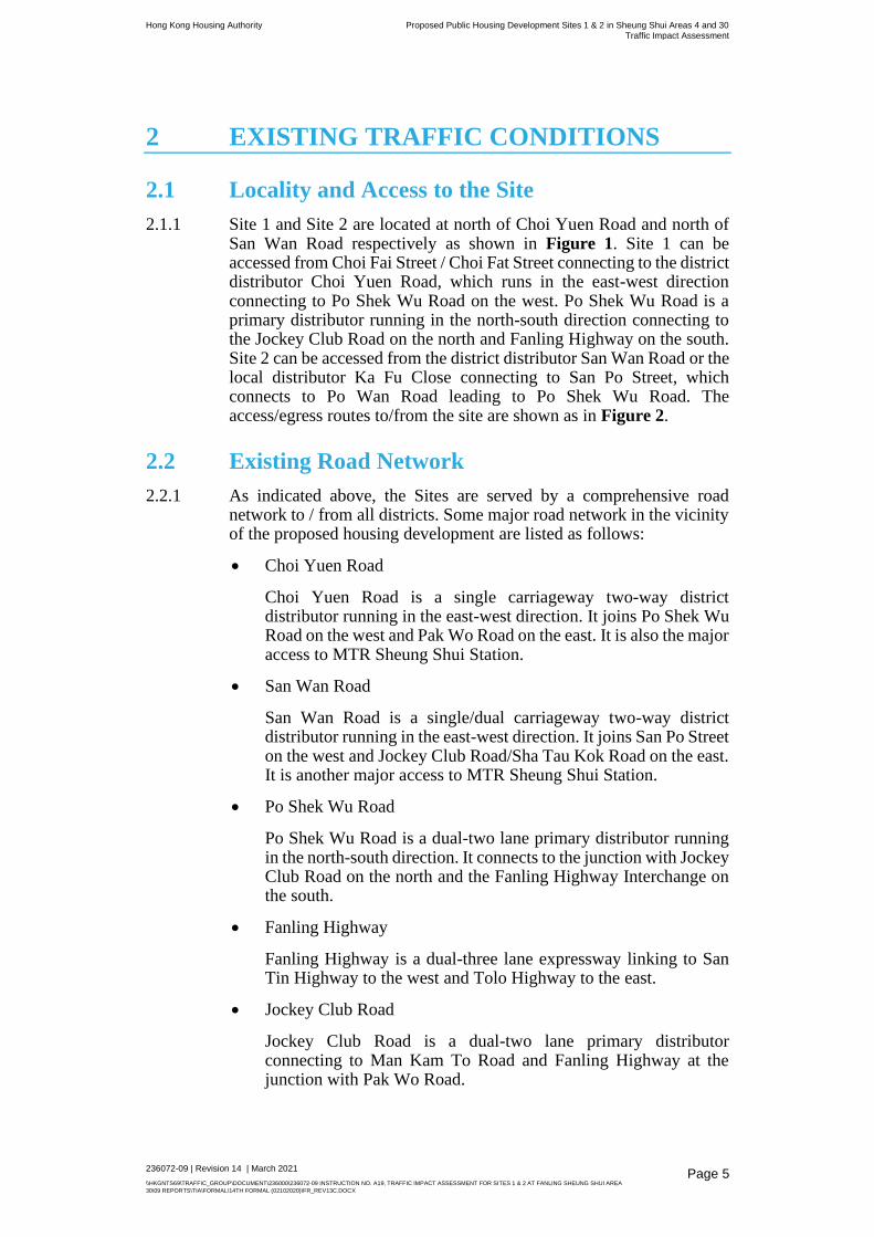
2.1.1 Site 1 and Site 2 are located at north of Choi Yuen Road and north of San Wan Road respectively as shown in Figure 1. Site 1 can be accessed from Choi Fai Street / Choi Fat Street connecting to the district distributor Choi Yuen Road, which runs in the east-west direction connecting to Po Shek Wu Road on the west. Po Shek Wu Road is a primary distributor running in the north-south direction connecting to the Jockey Club Road on the north and Fanling Highway on the south. Site 2 can be accessed from the district distributor San Wan Road or the local distributor Ka Fu Close connecting to San Po Street, which connects to Po Wan Road leading to Po Shek Wu Road. The access/egress routes to/from the site are shown as in Figure 2.
2.2 Existing Road Network
2.2.1 As indicated above, the Sites are served by a comprehensive road network to / from all districts. Some major road network in the vicinity of the proposed housing development are listed as follows:
• Choi Yuen Road
Choi Yuen Road is a single carriageway two-way district distributor running in the east-west direction. It joins Po Shek Wu Road on the west and Pak Wo Road on the east. It is also the major access to MTR Sheung Shui Station.
• San Wan Road
San Wan Road is a single/dual carriageway two-way district distributor running in the east-west direction. It joins San Po Street on the west and Jockey Club Road/Sha Tau Kok Road on the east. It is another major access to MTR Sheung Shui Station.
• Po Shek Wu Road
Po Shek Wu Road is a dual-two lane primary distributor running in the north-south direction. It connects to the junction with Jockey Club Road on the north and the Fanling Highway Interchange on the south.
• Fanling Highway
Fanling Highway is a dual-three lane expressway linking to San Tin Highway to the west and Tolo Highway to the east.
• Jockey Club Road
Jockey Club Road is a dual-two lane primary distributor connecting to Man Kam To Road and Fanling Highway at the junction with Pak Wo Road.

Hong Kong Housing Authority Proposed Public Housing Development Sites 1 & 2 in Sheung Shui Areas 4 and 30
Traffic Impact Assessment
236072-09 | Revision 14 | March 2021
\\HKGNTS69\TRAFFIC_GROUP\DOCUMENT\236000\236072-09 INSTRUCTION NO. A19, TRAFFIC IMPACT ASSESSMENT FOR SITES 1 & 2 AT FANLING SHEUNG SHUI AREA
30\09 REPORTS\TIA\FORMAL\14TH FORMAL (02102020)\FR_REV13C.DOCX
Page 6
• Ka Fu Close
Ka Fu Close is a single-two lane local distributor in the industrial area. It forms a local road network with other local roads, i.e. San Po Street and Cheuk Wan Street.
2.3 Existing Traffic Condition
2.3.1 To appreciate the existing traffic conditions, comprehensive classified traffic counts were conducted at the following key junctions and links. The assessments have been based on the latest junction layouts and method of control. Locations of these surveyed junctions and links are listed below and shown in Figure 1.
• J1 – Jockey Club Road / Po Shek Wu Road (Roundabout)
• J2 – Po Shek Wu Road / Po Wan Road (Signal Junction)
• J3 – Po Shek Wu Road / Choi Yuen Road (Signal Junction)
• J4 – Choi Yuen Road / Pak Wo Road (Roundabout)
• J5 – Jockey Club Road / Lung Sum Avenue (Signal Junction)
• J6 – Jockey Club Road / So Kwun Po Road (Signal Junction)
• J7 – So Kwun Po Road Interchange (Roundabout)
• J8 – Po Shek Wu Road Interchange (Roundabout)
• J9 – Po Wan Road / San Po Street (Signal Junction)
• J10 – San Wan Road / San Po Street (Priority)
• J11 – Choi Yuen Road / Choi Fai Street (Priority)
• J12 – Choi Fat Street / Choi Fai Street (Priority)
• J13 – Ka Fu Close / San Po Street (Priority)
• J14 – Ka Fu Close / Cheuk Wan Street (Priority)
• L1 – Po Shek Wu Road – Section between Choi Yuen Road and Fanling Highway
(Link)
• L2 – Po Shek Wu Road – Section between Choi Yuen Road and Po Wan Road
(Link)
• L3 - Po Shek Wu Road – Section between Jockey Club Road and Po Wan Road
(Link)
• L4 - Po Wan Road (Link)
• L5 – San Wan Road (Link)
• L6 – Choi Fat Road (Link)
• L7 – Choi Yuen Road (Link)
2.3.2 The traffic counts were undertaken on a normal weekday in 2016 during
the periods 0730 - 0930 and 1730 - 1930 hours. Supplementary survey
was conducted in May 2017 at Junctions J6, J7, J8 and Link L1. The
surveyed traffic flows in 2017 are in general higher than those of 2016.
It is revealed that the observed total flows of the most critical road links
in the town, i.e. Po Shek Wu Road and So Kwun Po Road, in 2017 is
Hong Kong Housing Authority Proposed Public Housing Development Sites 1 & 2 in Sheung Shui Areas 4 and 30
Traffic Impact Assessment
236072-09 | Revision 14 | March 2021
\\HKGNTS69\TRAFFIC_GROUP\DOCUMENT\236000\236072-09 INSTRUCTION NO. A19, TRAFFIC IMPACT ASSESSMENT FOR SITES 1 & 2 AT FANLING SHEUNG SHUI AREA
30\09 REPORTS\TIA\FORMAL\14TH FORMAL (02102020)\FR_REV13C.DOCX
Page 7
about 14% and 10% higher than those of 2016 during AM and PM peak
hours respectively. In view thereof, adjustment factor of 1.14 (for AM
peak) and 1.10 (for PM peak) to the traffic flows observed in 2016 is
therefore applied for assessment of existing traffic condition, except for
Junction J6, J7, J8 and Link L1 in which the observed traffic flows in
2017 are adopted. The adopted traffic flows to assess 2017 existing
junction performance are presented in Figure 3. From the observed
traffic flows in 2017, the morning and evening peak hours were
identified as 0730-0830 hours and 1730-1830 respectively. In general,
the morning peak hour flows were observed to be higher than the
evening peak periods.
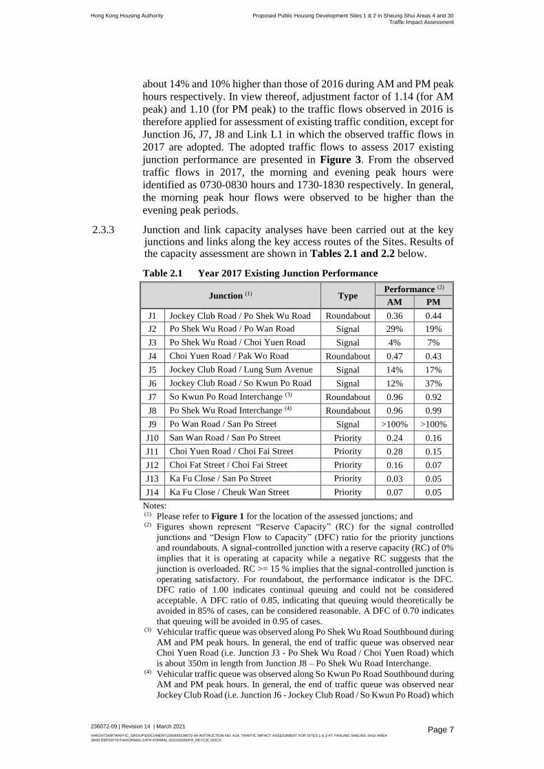
2.3.3 Junction and link capacity analyses have been carried out at the key junctions and links along the key access routes of the Sites. Results of the capacity assessment are shown in Tables 2.1 and 2.2 below.
Table 2.1 Year 2017 Existing Junction Performance
Junction (1) Type Performance (2)
AM PM
J1 Jockey Club Road / Po Shek Wu Road Roundabout 0.36 0.44
J2 Po Shek Wu Road / Po Wan Road Signal 29% 19%
J3 Po Shek Wu Road / Choi Yuen Road Signal 4% 7%
J4 Choi Yuen Road / Pak Wo Road Roundabout 0.47 0.43
J5 Jockey Club Road / Lung Sum Avenue Signal 14% 17%
J6 Jockey Club Road / So Kwun Po Road Signal 12% 37%
J7 So Kwun Po Road Interchange (3) Roundabout 0.96 0.92
J8 Po Shek Wu Road Interchange (4) Roundabout 0.96 0.99
J9 Po Wan Road / San Po Street Signal >100% >100%
J10 San Wan Road / San Po Street Priority 0.24 0.16
J11 Choi Yuen Road / Choi Fai Street Priority 0.28 0.15
J12 Choi Fat Street / Choi Fai Street Priority 0.16 0.07
J13 Ka Fu Close / San Po Street Priority 0.03 0.05
J14 Ka Fu Close / Cheuk Wan Street Priority 0.07 0.05
Notes: (1) Please refer to Figure 1 for the location of the assessed junctions; and (2) Figures shown represent “Reserve Capacity” (RC) for the signal controlled
junctions and “Design Flow to Capacity” (DFC) ratio for the priority junctions
and roundabouts. A signal-controlled junction with a reserve capacity (RC) of 0%
implies that it is operating at capacity while a negative RC suggests that the
junction is overloaded. RC >= 15 % implies that the signal-controlled junction is
operating satisfactory. For roundabout, the performance indicator is the DFC.
DFC ratio of 1.00 indicates continual queuing and could not be considered
acceptable. A DFC ratio of 0.85, indicating that queuing would theoretically be
avoided in 85% of cases, can be considered reasonable. A DFC of 0.70 indicates
that queuing will be avoided in 0.95 of cases. (3) Vehicular traffic queue was observed along Po Shek Wu Road Southbound during
AM and PM peak hours. In general, the end of traffic queue was observed near
Choi Yuen Road (i.e. Junction J3 - Po Shek Wu Road / Choi Yuen Road) which
is about 350m in length from Junction J8 – Po Shek Wu Road Interchange. (4) Vehicular traffic queue was observed along So Kwun Po Road Southbound during
AM and PM peak hours. In general, the end of traffic queue was observed near
Jockey Club Road (i.e. Junction J6 - Jockey Club Road / So Kwun Po Road) which

Hong Kong Housing Authority Proposed Public Housing Development Sites 1 & 2 in Sheung Shui Areas 4 and 30
Traffic Impact Assessment
236072-09 | Revision 14 | March 2021
\\HKGNTS69\TRAFFIC_GROUP\DOCUMENT\236000\236072-09 INSTRUCTION NO. A19, TRAFFIC IMPACT ASSESSMENT FOR SITES 1 & 2 AT FANLING SHEUNG SHUI AREA
30\09 REPORTS\TIA\FORMAL\14TH FORMAL (02102020)\FR_REV13C.DOCX
Page 8
is about 390m in length from Junction J7 – Po Shek Wu Road Interchange. For
southern side, the end of traffic queue was occasionally observed along Pak Wo
Road near J4 - Ching Hiu Road/ Pak Wo Road which is about 300m in length
from Junction J7 – So Kwun Po Road Interchange.
Table 2.2 Year 2017 Existing Road Link Performance
Road Links Direction Capacity
(pcu/hr) (1)
Flow (pcu/hr) V/C Ratio (2)
AM PM AM PM
L1
Po Shek Wu Road – Section
between Choi Yuen Road
and Fanling Highway
NB 4,700 1,810 2,175 0.39 0.46
SB 3,000 1,910 2,050 0.64 0.68
L2
Po Shek Wu Road – Section
between Choi Yuen Road
and Po Wan Road
NB 2,800 1,405 1,585 0.50 0.57
SB 2,800 1,290 1,425 0.46 0.51
L3
Po Shek Wu Road – Section
between Jockey Club Road
and Po Wan Road
NB 2,800 705 1,050 0.25 0.38
SB 2,800 880 1,205 0.31 0.43
L4 Po Wan Road EB 900 250 215 0.28 0.24
WB 1,800 315 170 0.18 0.09
L5 San Wan Road EB 1,800 110 100 0.06 0.06
WB 1,800 70 130 0.04 0.07
L6 Choi Fat Street EB 900 30 35 0.03 0.04
WB 900 105 85 0.12 0.09
L7 Choi Yuen Road EB 2,700 395 210 0.15 0.08
WB 1,800 215 315 0.12 0.18
Note: (1) Road capacity is defined in accordance to STM Model and TPDM Volume 2
Chapter 2.4 Table 2.4.1.1 by converting the vehicles to pcu for analysis; (2) A V/C ratio of 0.7 might infer adequate operating conditions, the effect of
junctions or traffic signals both within and at the end of the road link may be such
that the design flow could never be achieved in practice, and the link might be
severely congested well before a V/C ratio of 1.0 is reached.
2.3.4 Results of the analysis indicate that all junctions and links in the vicinity
of the Sites are currently operating within capacity.
2.4 Public Transport Facilities
2.4.1 The Sites are served by various modes of public transport services in vicinity. The key modes of public transport are:
• Franchised Bus Services – The Sites are served by comprehensive franchised bus services operating within the surrounding road network. The bus services operating in the vicinity of the Site are summarised in Table 2.3.
• Green Minibus (GMB) Services – The Sites are also served by GMB services operating within the surrounding road network. A summary of GMB services are found in Table 2.3.

Hong Kong Housing Authority Proposed Public Housing Development Sites 1 & 2 in Sheung Shui Areas 4 and 30
Traffic Impact Assessment
236072-09 | Revision 14 | March 2021
\\HKGNTS69\TRAFFIC_GROUP\DOCUMENT\236000\236072-09 INSTRUCTION NO. A19, TRAFFIC IMPACT ASSESSMENT FOR SITES 1 & 2 AT FANLING SHEUNG SHUI AREA
30\09 REPORTS\TIA\FORMAL\14TH FORMAL (02102020)\FR_REV13C.DOCX
Page 9
• The Sites are located within approximately 600m walking distance west of MTR Sheung Shui Station.
2.4.2 Figure 4 shows the locations of existing bus stops and GMB stops in vicinity of the Sites.
2.4.3 In summary, the Sites are serving with comprehensive public transport services via the adjacent railway network and the road-based public transport services (including franchised bus and GMB services).
2.4.4 In view of comprehensive coverage of the public transport services and the available different choices on transport modes, the proposed housing development is considered to have good accessibility via public transport.

Hong Kong Housing Authority Proposed Public Housing Development Sites 1 & 2 in Sheung Shui Areas 4 and 30 Traffic Impact Assessment
236072-09 | Revision 14 | March 2021
\\HKGNTS69\TRAFFIC_GROUP\DOCUMENT\236000\236072-09 INSTRUCTION NO. A19, TRAFFIC IMPACT ASSESSMENT FOR SITES 1 & 2 AT FANLING SHEUNG SHUI AREA 30\09 REPORTS\TIA\FORMAL\14TH FORMAL (02102020)\FR_REV13C.DOCX
Page 10
Table 2.3 Existing Public Transport Services
Route No. Origin - Destination Frequency
(minutes) Remarks
Bus
70K Wah Ming B/T ↔ Ching Ho 15 – 20 Circular route
73K Sheung Shui B/T ↔ Man Kam To 15 – 30
76K Ching Ho B/T ↔ Long Ping Estate B/T 20 – 30
77K Sheung Shui B/T ↔ Yuen Long (Fung Cheung Road) B/T 20 – 30
78K Sheung Shui B/T ↔ Sha Tau Kok B/T 15 – 30
79K Sheung Shui B/T ↔ Ta Kwu Ling 20 – 30
261 Sam Shing ↔ Ting Ping Estate B/T 20 – 30
261P Ng Tau Road (Tsing Lun Road) → Tin Ping Estate B/T - Monday to Saturday morning peak hour service only
270 Tin Ping Estate ↔ Tsui Lai Garden B/T 7 – 10 Circular Route
270A Sheung Shui B/T ↔ Tsim Sha Tsui East (Mody Road) 10 – 20
270B Sheung Shui B/T ↔ Shum Shui Po 15 – 60 Monday to Saturday morning peak hour service only Sunday noon peak hour service only
270P Sheung Shui B/T ↔ Kowloon Station - Monday to Saturday morning peak hour service only
270S Tsim Sha Tsui East (Mody Road) ↔ Luen Wo Hui B/T - 00:45-02:00 only
273A Choi Yuen B/T ↔ Wah Ming 4 – 10 Circular route
273B Ching Ho Estate B/T ↔ Sheung Shui Station 5 – 10 Circular route
273D Sheung Shui B/T ↔ Wah Ming 15 – 30 Circular route
276 Tin Tsz B/T ↔ Sheung Shui B/T 15 - 25
276A Tin Heng Estate B/T ↔ Tai Ping 5 – 15
276B Tin Fu ↔ Choi Yuen B/T 15 – 20
276P Tin Shui Wai Station ↔ Sheung Shui B/T 5 – 20
277E Tin Ping Estate B/T ↔ Lam Tin Station B/T 20
277P Tin Ping Estate B/T ↔ Lam Tin Station B/T 30 Monday to Friday morning peak hour service only
278X Sheung Shui B/T ↔ Tsuen Wan (Nina Tower) 5 – 20
279X Luen Wo Hui B/T ↔ Tsing Yi Station B/T 9 – 15

Hong Kong Housing Authority Proposed Public Housing Development Sites 1 & 2 in Sheung Shui Areas 4 and 30 Traffic Impact Assessment
236072-09 | Revision 14 | March 2021
\\HKGNTS69\TRAFFIC_GROUP\DOCUMENT\236000\236072-09 INSTRUCTION NO. A19, TRAFFIC IMPACT ASSESSMENT FOR SITES 1 & 2 AT FANLING SHEUNG SHUI AREA 30\09 REPORTS\TIA\FORMAL\14TH FORMAL (02102020)\FR_REV13C.DOCX
Page 11
Route No. Origin - Destination Frequency
(minutes) Remarks
373 Sheung Shui B/T ↔ Central (Hong Kong Station) - Monday to Saturday morning and afternoon peak hour service only
673 Sheung Shui B/T ↔ Central (Hong Kong Station) 30
678 Sheung Shui B/T ↔ Causeway Bay - Monday to Friday morning peak hour service only
978 Wah Ming B/T ↔ Wan Chai North 10 – 30
978A Luen Wo Hui B/T ↔ Wan Chai North - Monday to Friday morning peak hour service only
978B Chi Fok Circuit ↔ Wan Chai North - Monday to Friday morning peak hour service only
A43 Luen Wo Hui B/T ↔ Airport (Ground Transportation Centre) Terminus 15 – 30
A43P Luen Wo Hui B/T ↔ Airport (Ground Transportation Centre) Terminus 25 – 30
N42A Luen Wo Hui B/T ↔ Tung Chung Station - Night route
N42P Sheung Shui Station ↔ Airport (Ground Transportation Centre) Terminus - Night route
N73 Sheung Shui B/T ↔ Lok Ma Chau B/T 30 Night route
T270 Cheung Wah B/T ↔ Tsim Sha Tsui East (Mody Road) - Monday to Friday morning peak hour service only
T277 Sheung Shui B/T ↔ Lam Tin Station B/T - Monday to Friday morning peak hour service only
GMB
44 Tuen Mun Ferry Pier ↔ Sheung Shui Station 2 – 3
44A Tuen Mun Station PTI ↔ Sheung Shui Station 2 – 5
50A Sheung Shui Station ↔ Kwu Tung (South) 10 – 15 Circular route
50K Sheung Shui Station ↔ Hang Tau 5 – 25
51K Sheung Shui Station ↔ Ho Sheung Heung 7 – 20
55K Sheung Shui Station ↔ Sha Tau Kok (Shun Lung Street) 4 – 10
57K Sheung Shui Station ↔ Tong Kung Leng 8 – 30
58K Sheung Shui Station ↔ Ping Kong 10 – 30
58S Mong Kok Station ↔ Sheung Shui Station 12 – 15 Night route
59K Sheung Shui Station ↔ Lin Ma Hang 15 – 60
501S Sheung Shui Station ↔ Yue Man Square 15 – 20 Night route
605 Ki Lun Tsuen ↔ Sheung Shui Station 25

Hong Kong Housing Authority Proposed Public Housing Development Sites 1 & 2 in Sheung Shui Areas 4 and 30
Traffic Impact Assessment
236072-09 | Revision 14 | March 2021
\\HKGNTS69\TRAFFIC_GROUP\DOCUMENT\236000\236072-09 INSTRUCTION NO. A19, TRAFFIC IMPACT ASSESSMENT FOR SITES 1 & 2 AT FANLING SHEUNG SHUI AREA
30\09 REPORTS\TIA\FORMAL\14TH FORMAL (02102020)\FR_REV13C.DOCX
Page 12
3 THE PROPOSED HOUSING DEVELOPMENT
3.1 Site Description
3.1.1 Site 1 is bounded by Choi Fai Street on the north, Choi Yuen Road on the south and Po Shek Wu Road on the east. It is zoned “Industrial” (“I”) and currently an existing public car park under Short Term Tenancy (STT). The proposed public housing development will comprise of about 2,088 flats and is envisaged to be completed by Year 2025/2026 for Phase 1 (2 residential blocks), Year 2027 for a new PTI and Year 2029/2030 for Phase 2 (1 residential block). The site location and its environs in the vicinity are shown in Figure 1.
3.1.2 Site 2 is bounded by Ka Fu Close on the northeast, San Wan Road on the southeast and Po Shek Wu Road on the southeast. It is zoned “I” and “Other Specified Uses” annotated (Bus Depot) (“OU (Bus Depot)”) and partly as an existing public car park under STT and partly as WSD’s depot under TGLA. The proposed public housing development will comprise of about 1,556 flats (3 residential blocks) and is envisaged to be completed by Year 2025/2026. The site location and its environs in the vicinity are shown in Figure 1.
3.2 Development Schedule
3.2.1 Table 3.1 below summarises the latest development schedule of proposed housing development.
Table 3.1 Summary of Development Schedule
Development Site 1 Site 2
Public Housing
2,088 flats
(For Assessment:
2,297 flats)*
1,556 flats
(For Assessment:
1,712 flats)*
Retail 395 sqm GFA 700 sqm GFA
Post Office N/A N/A
Welfare Facilities 10,513 sqm GFA N/A
Kindergarten 6 classrooms N/A
Avg. Household Size
2.8 2.8
Population
5,847
(For Assessment: 6,432)*
4,357
(For Assessment: 4,794)*
Notes:
*With additional 10% allowance for the proposed number of flats for assessment
purpose.

Hong Kong Housing Authority Proposed Public Housing Development Sites 1 & 2 in Sheung Shui Areas 4 and 30
Traffic Impact Assessment
236072-09 | Revision 14 | March 2021
\\HKGNTS69\TRAFFIC_GROUP\DOCUMENT\236000\236072-09 INSTRUCTION NO. A19, TRAFFIC IMPACT ASSESSMENT FOR SITES 1 & 2 AT FANLING SHEUNG SHUI AREA
30\09 REPORTS\TIA\FORMAL\14TH FORMAL (02102020)\FR_REV13C.DOCX
Page 13
3.3 Car Parking and Loading / Unloading Provision
3.3.1 The proposed provision of parking and loading/unloading facilities were provided by HKHA based on the Hong Kong Planning Standards and Guidelines (HKPSG). The proposed provisions described in Table 3.2 have fully considered the subject development.
Table 3.2 Parking and Loading / Unloading Facilities Provision
Development Facility HKPSG Guideline Requirement Proposed Provision
Public Housing Development at Site 1
Public Housing
(2,088 flats, including
511 nos. of 1P/2P
flats)
(3 Residential Blocks)
Private Car Parking 1 per 26-40 flats (excluding 1P/ 2P
flats) 39-61 nos. 61 + 15 (1) nos.
Light Goods Vehicle Parking 1 per 200-600 flats (excluding 1P/ 2P
flats) 3-8 nos. 8 nos.
Motor cycle Parking 1 per 110-250 flats (excluding 1P/ 2P
flats) 7-15 nos. 15 nos.
Loading / Unloading 1 per residential block 3 nos. 3 nos.
Bicycle Parking 1 per 15 flats 140 nos. 140 + 40 (1) nos.
Retail
(395 sqm GFA)
Private Car Parking 1 per 200-300 sqm GFA 2 nos. 2 nos. parking spaces
Loading / Unloading 1 per 800-1200 sqm GFA 1 no. 1 nos. loading/ unloading
bay
Community Hall
(1,095 sqm GFA)
Private Car Parking As Per Operator’s Requirements
-
Loading / Unloading 1 no.
Welfare Facilities
(10,513 m2 GFA)
16-seater Van
As Per Operator’s Requirements
1 no.
24-seater Van 1 no.
Loading / Unloading 1 no.
Kindergarten
(6 classrooms)
Private Car Parking For schools and kindergartens within
public housing estates, the carparking
provisions, taxi and private car lay-bys
and loading/unloading provisions
should be subject to the requirements of
Housing Authority.
1 no.
Loading / Unloading 1 no.
Public Housing Development at Site 2
Public Housing
(1,556 flats including
119 nos. of 1P/2P
flats)
(3 Residential Blocks)
Private Car Parking 1 per 26-40 flats (excluding 1P/ 2P
flats) 36 - 56 nos. 56 + 15 (1) nos.
Light Goods Vehicle Parking 1 per 200-600 flats (excluding 1P/ 2P
flats) 3-8 nos. 8 nos.
Motor cycle Parking 1 per 110-250 flats (excluding 1P/ 2P
flats) 6 - 14 nos. 14 nos.
Loading / Unloading 1 per housing block 3 nos. 3 nos.
Bicycle Parking 1 per 15 flats 104 nos. 104 + 40 (1) nos.
Retail
(700 sqm GFA)
Private Car Parking 1 per 200-300 sqm GFA 3 - 4 nos. 4 nos.
Loading / Unloading 1 per 800-1200 sqm GFA 1 no. 1 no.
Note: (1) Additional private car and bicycle parking provision in accordance with the agreement
with Transport Department.
3.4 Access Arrangement / Pedestrian Facilities
Site 1

Hong Kong Housing Authority Proposed Public Housing Development Sites 1 & 2 in Sheung Shui Areas 4 and 30
Traffic Impact Assessment
236072-09 | Revision 14 | March 2021
\\HKGNTS69\TRAFFIC_GROUP\DOCUMENT\236000\236072-09 INSTRUCTION NO. A19, TRAFFIC IMPACT ASSESSMENT FOR SITES 1 & 2 AT FANLING SHEUNG SHUI AREA
30\09 REPORTS\TIA\FORMAL\14TH FORMAL (02102020)\FR_REV13C.DOCX
Page 14
3.4.1 Vehicles can access the Site 1 at Choi Fai Street via Choi Yuen Road connecting to Po Shek Wu Road, which links to Jockey Club Road to the north and Fanling Highway to the south.
3.4.2 There will be 2 nos. of vehicular accesses for the Site to provide Emergency Vehicular Accesses (EVA). The detailed arrangement of the proposed vehicular accesses is indicated in Figure 1.
3.4.3 The internal road system within the proposed development is subject to detailed design. The Emergency Vehicular Access (EVA) should be of a minimum 6m in width wherever applicable in the internal road system and fully comply with requirements of “Code of Practices of Means of Access for Firefighting and Rescue” by Buildings Department.
3.4.4 The existing pedestrian facilities are well-developed in the vicinity of the Site. The existing footpath will be maintained on Choi Fat Street and Choi Yuen Road. Pedestrians can access the proposed development via the surrounding pedestrian facilities connecting to the nearby bus / GMB termini and MTR Sheung Shui Station.
3.4.5 A footbridge is proposed to connect the proposed development to the future public housing development site at Choi Yuen Road Sites 3 and 4 (now named as Po Shek Wu Estate), with new footbridges connecting to Po Shek Wu Road Site and the existing footbridge linking Choi Yuk House on the south and Landmark North on the north. An operational capacity assessment for existing pedestrian facilities have been conducted and will be discussed in Section 5 to access the capability of existing facilities to cater for future demand.
Site 2
3.4.6 Vehicles can access the Site 2 at Ka Fu Close via San Po Street and Po Wan Road connecting to Po Shek Wu Road, which links to Jockey Club Road to the north and Fanling Highway to the south.
3.4.7 There will be 1 no. of vehicular access for the Site on Ka Fu Close and a separate vehicular access to serve the car park block via Ka Fu Close. The detailed arrangement of the proposed vehicular accesses is indicated in Figure 1.
3.4.8 The internal road system within the proposed development is subject to detailed design. The Emergency Vehicular Access (EVA) should be of a minimum 6m in width wherever applicable in the internal road system and fully comply with requirements of “Code of Practice for Fire Safety in Buildings 2011” by Buildings Department.
3.4.9 The existing pedestrian facilities are well-developed in the vicinity of the Site. The existing footpath will be maintained on San Wan Road and Ka Fu Close. A new footbridge is proposed to connect the proposed development to Po Shek Wu Road Site, with new footbridges connecting to Po Shek Wu Estate and the existing footbridge linking Choi Yuk House on the south and Landmark North on the north. The comprehensive footbridge network connecting different public housing developments will enhance the pedestrian accessibility. Details on the pedestrian facilities assessment will be discussed in Section 5.

Hong Kong Housing Authority Proposed Public Housing Development Sites 1 & 2 in Sheung Shui Areas 4 and 30
Traffic Impact Assessment
236072-09 | Revision 14 | March 2021
\\HKGNTS69\TRAFFIC_GROUP\DOCUMENT\236000\236072-09 INSTRUCTION NO. A19, TRAFFIC IMPACT ASSESSMENT FOR SITES 1 & 2 AT FANLING SHEUNG SHUI AREA
30\09 REPORTS\TIA\FORMAL\14TH FORMAL (02102020)\FR_REV13C.DOCX
Page 15
3.4.10 In addition, a possible footbridge connection connecting the existing footbridge to Sheung Shui MTR Station would be provided subject to further investigation at detail design stage. Figure 15 shows the overview of the proposed footbridge network in the vicinity of the subject site.
3.5 Re-provision of Private Car Parking Space
3.5.1 Separate parking study was conducted in 2016 to review the parking condition in vicinity of the proposed developments, it was observed that there would be shortfall in about 270 nos. of private car parking spaces after closure of the affected public car parks under STT (currently providing about 470 nos. of car parking spaces) as mentioned in Section 3.1.2.
3.5.2 Permanent re-provision of private car parking space will be provided in the new car park block at Site 2, providing about 320 nos. of private car parking spaces.
3.5.3 During the construction stage of proposed development and the new car park block which is planned to be commenced in 2021/22, 300 nos. of private car parking spaces will be temporarily provided at portion of Site 1 and/or Site 2 under STT. Construction work at this portion of Site 1 and/or Site 2 will be commenced after the operation of the new car park block at Site 2 targeted in 2024/25. In conclusion, at least 300 nos. of private car parking space will always be provided during and after the construction works.
3.5.4 For goods vehicle parking, HKHA already suggested LandsD and relevant departments to make new STT sites and convert the existing STT car parks for goods vehicles and coach/bus parking only, in order to provide additional parking provision for large vehicles after closure of the concerned STT Car Parks for tackling the public car park issue in short term. For long term solution, it will be explored in the upcoming Phase 2 study of Sheung Shui Areas 4 and 30 pending the findings of Phase 1 Study.

Hong Kong Housing Authority Proposed Public Housing Development Sites 1 & 2 in Sheung Shui Areas 4 and 30
Traffic Impact Assessment
236072-09 | Revision 14 | March 2021
\\HKGNTS69\TRAFFIC_GROUP\DOCUMENT\236000\236072-09 INSTRUCTION NO. A19, TRAFFIC IMPACT ASSESSMENT FOR SITES 1 & 2 AT FANLING SHEUNG SHUI AREA
30\09 REPORTS\TIA\FORMAL\14TH FORMAL (02102020)\FR_REV13C.DOCX
Page 16
4 FUTURE TRAFFIC CONDITIONS
4.1 Assessment Scenarios
4.1.1 To evaluate the associated traffic impact likely to be induced by the proposed change in land use, four scenarios were analysed and compared. The 1st and 3rd scenarios are Reference Scenario (without the proposed housing developments) in Year 2030 and 2033. The 2nd and 4th scenarios are Design Scenarios (with the proposed housing developments) in Year 2030 and 2033, respectively.
4.1.2 Taking into consideration that the proposed development will be completed by 2029/2030 and phased commissioning of NDA development area and Fanling Bypass, years 2030 and 2033 were adopted as the design years in the study. The year 2030 scenario would demonstrate the traffic conditions in the study area after completion of the proposed development. The year 2033 scenario would demonstrate the traffic conditions in the study area 3 years after completion of the proposed development respectively, taking into account of the change of traffic pattern before/ after the phased commissioning of NDA development area and Fanling Bypass.
4.1.3 Four assessment scenarios were assessed for the design years, namely:
• 2030 Reference Case (2030 Background Traffic Flows including
generated/attracted traffic related to other planned developments
in the vicinity)
• 2030 Design Case (2030 Reference Case Traffic Flows +
generated/attracted traffic related to the proposed development)
• 2033 Reference Case (2033 Background Traffic Flows including
generated/attracted traffic related to other planned developments
in the vicinity)
• 2033 Design Case (2033 Reference Case Traffic Flows +
generated/attracted traffic related to the proposed development)
4.1.4 The methodology adopted to forecast the traffic for the future years is presented in the next section.
4.1.5 The forecasted traffic flows for above assessment scenarios are shown in Figures 5 to 8.
4.2 Forecasting Methodology
Proposed Area of Influence (AOI)
4.2.1 Area of Influence (AOI) is proposed and presented in Figure 1. It covers the critical road junctions and road networks in Sheung Shui Town, which may be affected by the proposed development in the Site. Necessary data and information within the AOI have been collected and assembled for assessments.
New Development Area (NDA)

Hong Kong Housing Authority Proposed Public Housing Development Sites 1 & 2 in Sheung Shui Areas 4 and 30
Traffic Impact Assessment
236072-09 | Revision 14 | March 2021
\\HKGNTS69\TRAFFIC_GROUP\DOCUMENT\236000\236072-09 INSTRUCTION NO. A19, TRAFFIC IMPACT ASSESSMENT FOR SITES 1 & 2 AT FANLING SHEUNG SHUI AREA
30\09 REPORTS\TIA\FORMAL\14TH FORMAL (02102020)\FR_REV13C.DOCX
Page 17
4.2.2 Considering the traffic impact of the future development at New Development Area (NDA), it is expected that the future traffic patterns (i.e. design years 2030 and 2033) will be complex by the changes in the NDA. The complexity of growth in overall transport demand, coupled with the anticipated significant changes in pattern, would complicate the future traffic forecast. To maintain accuracy, it is recommended that comprehensive traffic forecast should be adopted, taking into account of the latest development proposal of NDA and the future road network and highway for the Year 2030 and Year 2033 traffic.
Other Planned/Committed Developments in the Vicinity of Site
4.2.3 Besides NDA, there are some other planned/committed developments in the vicinity of the Sites, including:
• Proposed Committed Public Housing Development at Po Shek Wu Estate;
• Proposed Public Housing Development at Po Shek Wu Road, Sheung Shui;
• Proposed Wholesale Conversion into Retail Development from Existing Advanced Technology Centre at No.2 Choi Fat Street, Sheung Shui;
• Proposed Wholesale Conversion into Office-cum-Retail Building from Existing Industrial Building at No.9 Choi Yuen Road, Sheung Shui;
• Proposed Wholesale Conversion into Retail Development at No. 6 Choi Fai Street, Sheung Shui; and
• Proposed Wholesale Conversion into Office-cum-Retail Building at No. 21 Po Wan Road, Sheung Shui
4.2.4 The estimated trips of these developments have also been reviewed and incorporated into the development of traffic forecast, as appropriate. Trip generation / attraction by proposed housing development of Po Shek Wu Estate are reference to the HKHA’s Traffic Impact Assessment (TIA) Report for Po Shek Wu Estate. Trip generation / attraction of Site at Po Shek Wu Road are estimated from trip generation rates of public housing development stipulated in TPDM as shown in Table 4.1. Summary of the trip generation of these public housing developments is given in Table 4.2 respectively.

Hong Kong Housing Authority Proposed Public Housing Development Sites 1 & 2 in Sheung Shui Areas 4 and 30
Traffic Impact Assessment
236072-09 | Revision 14 | March 2021
\\HKGNTS69\TRAFFIC_GROUP\DOCUMENT\236000\236072-09 INSTRUCTION NO. A19, TRAFFIC IMPACT ASSESSMENT FOR SITES 1 & 2 AT FANLING SHEUNG SHUI AREA
30\09 REPORTS\TIA\FORMAL\14TH FORMAL (02102020)\FR_REV13C.DOCX
Page 18
Table 4.1 Trip Generation / Attraction Rates for Public Housing
Development at Po Shek Wu Road
Development Type AM Peak PM Peak
Generation Attraction Generation Attraction
Subsidised Housing:
HOS/PSPS/SSF
(pcu/flat/hr) (1)
0.0622 0.0426 0.0297 0.0401
Retail / Shopping Complex
(pcu/hr/100 m2 GFA) (1) 0.2296 0.2434 0.3100 0.3563
Note: (2) Reference to “Traffic Rates for Residential Developments at 95% Confidence Level”,
Transport Planning and Design Manual (TPDM), Volume 1
Table 4.2 Estimated Trip Generation / Attraction for other Planned
Public Housing Development in the Vicinity of the Sites
Development AM Peak PM Peak
Generation Attraction Generation Attraction
Public Housing Development at Po Shek Wu Estate (1)
PRH
(Planned: 1,160 flats) (1) 65 53 34 41
Retail
(790 m2 GFA) (1) 2 2 3 3
6-Classroom Kindergarten, Welfare
facilities
(2,604 m2 GFA) (1)
30 30 30 30
Public Car Park
(221 nos. of space) (1) 18 35 42 40
Total of Po Shek Wu Estate 115 120 109 114
Public Housing Development at Po Shek Wu Road
SSF
(Planned: 1,850 flats) 115 79 55 74
Retail
(3,000 m2 GFA) 7 7 9 11
Kindergarten
(6-Classroom) (2) 30 30 30 30
Total of Site at Po Shek Wu Road 152 116 94 115
Note: (1) Trip generation / attraction of Po Shek Wu Estate are reference to HKHA’s TIA Report of
Po Shek Wu Estate; and (2) For the kindergarten and welfare facilities, a nominal traffic of total 30 pcu/hr each way is
assumed for these facilities as a conservative approach, in view of the minimal trips
induced on the road networks during ordinary peak hours.
4.2.5 Trip generation / attraction by planned private retail and office development are reference to the Traffic Impact Assessment (TIA) Report by the corresponding developers under the S.16 Application.

Hong Kong Housing Authority Proposed Public Housing Development Sites 1 & 2 in Sheung Shui Areas 4 and 30
Traffic Impact Assessment
236072-09 | Revision 14 | March 2021
\\HKGNTS69\TRAFFIC_GROUP\DOCUMENT\236000\236072-09 INSTRUCTION NO. A19, TRAFFIC IMPACT ASSESSMENT FOR SITES 1 & 2 AT FANLING SHEUNG SHUI AREA
30\09 REPORTS\TIA\FORMAL\14TH FORMAL (02102020)\FR_REV13C.DOCX
Page 19
Summary of the trip generation of these private development is given in Table 4.3 respectively.
Table 4.3 Estimated Trip Generation / Attraction for Other Planned
Private Development in the Vicinity of the Sites
Development AM Peak PM Peak
Generation Attraction Generation Attraction
Proposed Wholesale Conversion into Retail Development from Existing Advanced Technology Centre at No.2 Choi Fat Street, Sheung Shui (1)
24 16 15 19
Proposed Wholesale Conversion into Office-cum-Retail Building from Existing Industrial Building at No.9 Choi Yuen Road, Sheung Shui (2)
45 64 37 34
Proposed Wholesale Conversion into Retail Development at No. 6 Choi Fai Street, Sheung Shui (3)
69 73 93 107
Proposed Wholesale Conversion into Office-cum-Retail Building at No. 21 Po Wan Road, Sheung Shui (3)
9 12 12 12
Note: (1) Trip generation / attraction are reference to the net changes of trip generation / attraction
stipulated in Developer’s TIA Report under the S.16 Application No. A/FSS/246; (2) Trip generation / attraction are reference to the net changes of trip generation / attraction
stipulated in Developer’s TIA Report under the S.16 Application No. A/FSS/241; and (3) Trip generation / attraction are reference to the estimated trip generation / attraction
stipulated in TIA Report under S.16 Application No. A/FSS/241.
2-Tier Transport Modelling
4.2.6 A two-tier modelling approach was adopted. The upper tier involved the use of Arup’s in-house CTS-compatible Traffic Model (TM) which produced traffic forecasts on a strategic basis. The cordoned matrices from the TM would then be input into the lower tier Local Area Traffic Model (LATM) which would be used to predict the future year traffic flow on a more local perspective. The modelling approach is elaborated in the following sections.
Upper Tier Model
4.2.7 Arup’s in-house CTS-compatible TM was applied as the upper tier model. The TM was capable of producing trip matrices for the base and future years throughout the territory. The TM also offered the advantage of being capable of reflecting the traffic impacts especially the mode choice caused due to changes of road networks. It was hence recommended to adopt this model as the basis, and updated using the latest available planning data in the Enhanced 2011-based Territorial Population and Employment Data Matrix (TPEDM), planned and committed new infrastructures and local developments, including private development at Castle Peak Road – Kwu Tung (Rezoning Application No. Y/FSS/14), private development at Pak Wo Road 5

Hong Kong Housing Authority Proposed Public Housing Development Sites 1 & 2 in Sheung Shui Areas 4 and 30
Traffic Impact Assessment
236072-09 | Revision 14 | March 2021
\\HKGNTS69\TRAFFIC_GROUP\DOCUMENT\236000\236072-09 INSTRUCTION NO. A19, TRAFFIC IMPACT ASSESSMENT FOR SITES 1 & 2 AT FANLING SHEUNG SHUI AREA
30\09 REPORTS\TIA\FORMAL\14TH FORMAL (02102020)\FR_REV13C.DOCX
Page 20
(Rezoning Application No. Y/FSS/13), public housing development at Sheung Shui Area 36 Phase 4 (Ching Ho Extension), Kong Nga Po Police Facilities and Sandy Ridge Columbarium and Crematorium Development for this study.
4.2.8 In order to ensure the traffic patterns predicted by the model could reasonably replicate the current traffic condition and hence provided confidence in forecasting the future year traffic, the output from the base year TM was compared against observed traffic flows as published in the Annual Traffic Census for both the AM and PM peak hours.
Lower Tier Model
4.2.9 Matrices cordoned from the TM were input into the LATM. Despite the LATM only performs traffic assignment, it offered the benefit of giving more detailed accounting of queuing, junction control and delays, making it more suitable for the evaluation of localized traffic impacts.
4.2.10 The development of the LATM would follow the same approach as TD’s latest 2008-based Base District Traffic Model (BDTM). The compatibility between the 2 tiers was ensured by the control of the external trip ends, which were essentially the link flows of Fanling Highway, Fan Kam Road, Castle Peak Road – Kwu Tung, obtained from the TM. The link flows and junction turning counts on a more local level would be produced by the LATM assignments for subsequent impact assessments.
4.2.11 Validation was also carried out for the LATM and additional focus was given to the comparison of observed and modelled flows at both strategic and local road links. Supplementary traffic survey had been conducted to provide traffic flows and turning counts which were not available in the Annual Traffic Census.
4.2.12 As survey counts represented the Year 2017 observed traffic flows, it was proposed to adopt Year 2017 as the LATM base year, and the LATM was validated to Year 2017 conditions.
4.2.13 The LATM has been developed for the area of N.T. North District, in which the traffic condition could be fully represented.
Trip Generation / Attraction for Proposed Public Housing Development of Sites 1 and 2 at Sheung Shui Areas 4 and 30
4.2.14 For the proposed development trip generation and attraction, trip rates were made reference to Transport Department’s Transport Planning and Design Manual (TPDM) Volume 1 Chapter 3 - Transport Considerations in Town Plans. The adopted trip rates for the proposed development are shown in Table 4.4.

Hong Kong Housing Authority Proposed Public Housing Development Sites 1 & 2 in Sheung Shui Areas 4 and 30
Traffic Impact Assessment
236072-09 | Revision 14 | March 2021
\\HKGNTS69\TRAFFIC_GROUP\DOCUMENT\236000\236072-09 INSTRUCTION NO. A19, TRAFFIC IMPACT ASSESSMENT FOR SITES 1 & 2 AT FANLING SHEUNG SHUI AREA
30\09 REPORTS\TIA\FORMAL\14TH FORMAL (02102020)\FR_REV13C.DOCX
Page 21
Table 4.4 Adopted Trip Generation / Attraction Rates for Proposed
Housing Development Sites 1 and 2
Development AM Peak PM Peak
Generation Attraction Generation Attraction
Subsidised Housing: Public Rental
Average Flat Size of 30sqm
(pcu/flat/hr) (1) 0.0242 0.0226 0.0177 0.0201
Retail / Shopping Complex
(pcu/hr/100 m2 GFA) (1) 0.2296 0.2434 0.3100 0.3563
Source: (1) ‘Traffic Rates for Residential Developments at 95% Confidence Level’,
Transport Planning and Design Manual (TPDM), Volume 1
4.2.15 Trip rates of proposed development had also been referenced to the traffic generation survey conducted at the similar development in North District. The traffic generation surveys were undertaken during AM & PM peak hours on a normal weekday. The observed peak traffic generation rates are tabulated in Table 4.5.
Table 4.5 Summary on Surveyed Trip Rates at Existing Public
Housing Development in North District
Development AM Peak PM Peak
Generation Attraction Generation Attraction
Wah Ming Estate – 5,340 flats
(pcu/flat/hr) 0.0171 0.0125 0.0073 0.0127
Ching Ho Estate – 7,200 flats
(pcu/flat/hr) 0.0175 0.0085 0.0078 0.0158
4.2.16 For public housing development, it is observed that the surveyed trips rates for both AM and PM peaks shown in Table 4.5 are much lower than the mean values of rate stated in TPDM according to Table 4.4. It is therefore recommended to adopt the mean values of rate stated in TPDM for conservative assessment purpose.
4.2.17 For Site 1, there are about 2,088 flats in the public housing development, 395 sqm GFA of retail facilities, 10,513 sqm GFA of social welfare facilities, 886 sqm GFA of kindergarten. To adopt a conservative approach for the subject planned housing sites, a 10% increase in flat number (i.e. 2,297 flats) is adopted for estimating the traffic generated / attracted by the development for traffic impact assessment purpose. For the kindergarten and welfare facilities in the Site, a nominal traffic of total 30 pcu/hr each way is assumed for these facilities, since they are expected to induce minimal trips on the road network.
4.2.18 For Site 2, there are about 1,556 flats in the public housing
development, 700 sqm GFA of retail facilities and a public car park in
the Site. To adopt a conservative approach for the subject planned
housing sites, a 10% increase in flat number (i.e. 1,712 flats) is adopted
for estimating the traffic generated / attracted by the development for
traffic impact assessment purpose. On the other hand, as the subject site

Hong Kong Housing Authority Proposed Public Housing Development Sites 1 & 2 in Sheung Shui Areas 4 and 30
Traffic Impact Assessment
236072-09 | Revision 14 | March 2021
\\HKGNTS69\TRAFFIC_GROUP\DOCUMENT\236000\236072-09 INSTRUCTION NO. A19, TRAFFIC IMPACT ASSESSMENT FOR SITES 1 & 2 AT FANLING SHEUNG SHUI AREA
30\09 REPORTS\TIA\FORMAL\14TH FORMAL (02102020)\FR_REV13C.DOCX
Page 22
is currently a public car park (providing about 470 nos. of private car
parking space), the proposed future car park (providing about 320 nos.
of private car parking space) should not induce additional increase of
traffic in view of the similar use as existing facilities. It is also
considered to be conservative in view of the smaller scale of the
proposed car park compared with the existing car park. On the other
hand, as the traffic generated / attracted from/to the post office are
expected to fall outside the peak hours and would be minimal during
the peak hours, the traffic from these facilities are neglected in the
assessment.
4.2.19 The traffic generation by the proposed development are summarised in Table 4.6. The total trips would be around 255 and 224 two-way pcus/hr during the AM and PM peak periods respectively.
Table 4.6 Estimated Trips for the Subject Site
Development AM Peak PM Peak
Generation Attraction Generation Attraction
Public Housing Development at Site 1
Public Housing
*(Planned: 2,088 flats
Assessment Purpose: 2,297 flats) (1)
56 52 41 47
Retail
(395 m2 GFA) 1 1 2 2
Kindergarten (6 classrooms) and Welfare facilities (10,513 m2 GFA)
30 30 30 30
Total of Site 1 87 83 73 79
Public Housing Development at Site 2
Public Housing
*(Planned: 1,556 flats
Assessment Purpose: 1,712 flats) (1)
42 39 31 35
Retail
(700 m2 GFA) 2 2 3 3
Public Car Park
(about 320 spaces)
no additional traffic generated / attracted are expected in view of the existing car park within the site
Total of Site 2 44 41 34 38
Total (Site 1+ Site 2) 131 124 107 117
Note: (1) With additional 10% allowance for the proposed number of flats
Planned/ Committed Junction Improvement Schemes by Other Projects
4.2.20 Junction improvement schemes were recommended in other study of projects in the vicinity of the Sites. The junction improvement schemes, which are considered in the study, are summarized in Table 4.7 below. The junction improvement schemes considered are based on the latest

Hong Kong Housing Authority Proposed Public Housing Development Sites 1 & 2 in Sheung Shui Areas 4 and 30
Traffic Impact Assessment
236072-09 | Revision 14 | March 2021
\\HKGNTS69\TRAFFIC_GROUP\DOCUMENT\236000\236072-09 INSTRUCTION NO. A19, TRAFFIC IMPACT ASSESSMENT FOR SITES 1 & 2 AT FANLING SHEUNG SHUI AREA
30\09 REPORTS\TIA\FORMAL\14TH FORMAL (02102020)\FR_REV13C.DOCX
Page 23
public available information. The general arrangement are shown as Appendix A.
Table 4.7 Summary of Junction Improvement Schemes by Others
Junction (1) Type Description Completion
Year
Design Scenarios
Considered
Drawing No. in Appendix A (2)
J3
Po Shek Wu Road / Choi Yuen Road
Signal
Phase 1
➢ Lane arrangement of the Choi Yuen Road westbound to be revised for providing two left-turn lanes
Phase 2
➢ Po Shek Wu Interchange Improvement which provides a flyover to allow the right turning traffic from Po Shek Wu Road southbound to Fanling Highway westbound to bypass the existing Po Shek Wu Interchange
➢ Po Shek Wu Road southbound would be narrowed from 5 lanes to 4 lanes
Already Completed
under Queen’s
Hill Project
(Phase 1)
Year 2029
(Phase 2)
Year 2030
&
Year 2033
A1, A2
J5
Jockey Club Road / Lung Sum Avenue
Signal
➢ Lane arrangement of the Lung Sum Avenue northbound/southbound to be revised for allowing straight-ahead traffic to use two traffic lanes
➢ Widening the Lung Sum Avenue northbound by narrowing the central median of Lung Sum Avenue
Year 2021
Year 2030
&
Year 2033
A3
J7 So Kwun Po Road Interchange
Roundabout
➢ Local widening of southbound approach arm of So Kwun Po Road for a smoother entrance to the elevated roundabout
Year 2021
Year 2030
&
Year 2033
A4
J8 Po Shek Wu Road Interchange
Roundabout
➢ Local widening of southbound approach arm of Po Shek Wu Road to 10m to have two traffic lanes when approaching the roundabout
Year 2021
Year 2030
&
Year 2033
A5

Hong Kong Housing Authority Proposed Public Housing Development Sites 1 & 2 in Sheung Shui Areas 4 and 30
Traffic Impact Assessment
236072-09 | Revision 14 | March 2021
\\HKGNTS69\TRAFFIC_GROUP\DOCUMENT\236000\236072-09 INSTRUCTION NO. A19, TRAFFIC IMPACT ASSESSMENT FOR SITES 1 & 2 AT FANLING SHEUNG SHUI AREA
30\09 REPORTS\TIA\FORMAL\14TH FORMAL (02102020)\FR_REV13C.DOCX
Page 24
Notes: (1) Please refer to Figure 1 for the location of the assessed junctions. (2) The general arrangement of junction improvement scheme are shown in
Appendix A. (3) Road L4 and Kwu Tung Interchange are assumed to be in place in Year 2030 and
2033 assessment scenarios.
4.3 Junction Capacity Assessment
4.3.1 Junction and link capacity assessment were undertaken based on the
methodology presented in the TPDM. The results for the 2030 and 2033
reference and design cases are shown in Tables 4.8 - 4.11.
Table 4.8 Summary of Junction Performance – Year 2030
Junction (1) Type
Junction Performance
Reference Case (2) Design Case (2)
AM PM AM PM
J1 Jockey Club Road / Po Shek Wu Road Roundabout 0.54 0.54 0.55 0.55
J2 Po Shek Wu Road / Po Wan Road Signal -6% -4% -8% -6%
J3 Po Shek Wu Road / Choi Yuen Road Signal 18% 15% 15% 13%
J4 Choi Yuen Road / Pak Wo Road Roundabout 0.47 0.43 0.48 0.44
J5 Jockey Club Road / Lung Sum Avenue Signal 1% 34% -1% 32%
J6 Jockey Club Road / So Kwun Po Road Signal -28% -14% -28% -14%
J7 So Kwun Po Road Interchange Roundabout 1.04 1.02 1.04 1.02
J8 Po Shek Wu Road Interchange Roundabout 0.78 0.75 0.82 0.77
J9 Po Wan Road / San Po Street Signal 87% >100% 76% >100%
J10 San Wan Road / San Po Street Priority 0.31 0.10 0.31 0.10
J11 Choi Yuen Road / Choi Fai Street Priority 0.32 0.41 0.44 0.53
J12 Choi Fat Street / Choi Fai Street Priority 0.15 0.19 0.26 0.32
J13 Ka Fu Close / San Po Street Priority 0.03 0.03 0.10 0.07
J14 Ka Fu Close / Cheuk Wan Street Priority 0.09 0.07 0.10 0.09
Notes: (1) Please refer to Figure 1 for the location of the assessed junctions; and (2) Figures shown represent “Reserve Capacity” (RC) for the signal controlled
junctions and “Design Flow to Capacity” (DFC) ratio for the roundabout. A
signal-controlled junction with a reserve capacity (RC) of 0% implies that it is
operating at capacity while a negative RC suggests that the junction is overloaded.
RC >= 15 % implies that the signal-controlled junction is operating satisfactory.
For roundabout, the performance indicator is the DFC. DFC ratio of 1.00 indicates
continual queuing and could not be considered acceptable. A DFC ratio of 0.85,
indicating that queuing would theoretically be avoided in 85% of cases, can be
considered reasonable. A DFC of 0.70 indicates that queuing will be avoided in
0.95 of cases.

Hong Kong Housing Authority Proposed Public Housing Development Sites 1 & 2 in Sheung Shui Areas 4 and 30
Traffic Impact Assessment
236072-09 | Revision 14 | March 2021
\\HKGNTS69\TRAFFIC_GROUP\DOCUMENT\236000\236072-09 INSTRUCTION NO. A19, TRAFFIC IMPACT ASSESSMENT FOR SITES 1 & 2 AT FANLING SHEUNG SHUI AREA
30\09 REPORTS\TIA\FORMAL\14TH FORMAL (02102020)\FR_REV13C.DOCX
Page 25
Table 4.9 Year 2030 Road Link Performance
Road Links Direction Capacity
(pcu/hr) (1)
Road Link Performance
Reference Case Design Case
Flow (pcu/hr) V/C Ratio (2) Flow (pcu/hr) V/C Ratio (2)
AM PM AM PM AM PM AM PM
L1
Po Shek Wu Road –
Section between Choi
Yuen Road and
Fanling Highway
NB 3,000 2,125 2,550 0.71 0.85 2,220 2,635 0.74 0.88
SB 3,000 1,855 1,980 0.62 0.66 1,910 2,045 0.64 0.68
L2
Po Shek Wu Road –
Section between Choi
Yuen Road and Po
Wan Road
NB 2,800 1,815 1,840 0.65 0.66 1,850 1,865 0.66 0.67
SB 2,800 1,050 1,080 0.38 0.39 1,070 1,110 0.38 0.40
L3
Po Shek Wu Road –
Section between
Jockey Club Road and
Po Wan Road
NB 2,800 1,120 1,445 0.40 0.52 1,155 1,455 0.41 0.52
SB 2,800 1,680 1,715 0.60 0.61 1,690 1,725 0.60 0.62
L4 Po Wan Road EB 900 275 275 0.31 0.31 310 300 0.34 0.33
WB 1,800 550 195 0.31 0.11 585 220 0.33 0.12
L5 San Wan Road EB 1,800 205 120 0.11 0.07 215 130 0.12 0.07
WB 1,800 115 135 0.06 0.08 120 145 0.07 0.08
L6 Choi Fat Street EB 900 85 130 0.09 0.14 165 205 0.18 0.23
WB 900 95 70 0.11 0.08 155 130 0.17 0.14
L7 Choi Yuen Road EB 2,700 465 350 0.17 0.13 525 415 0.19 0.15
WB 1,800 505 630 0.28 0.35 590 710 0.33 0.39
Note: (1) Road capacity is defined in accordance to STM Model and TPDM Volume 2
Chapter 2.4 Table 2.4.1.1 by converting the vehicles to pcu for analysis; (2) A V/C ratio of 0.7 might infer adequate operating conditions, the effect of
junctions or traffic signals both within and at the end of the road link may be such
that the design flow could never be achieved in practice, and the link might be
severely congested well before a V/C ratio of 1.0 is reached.
Hong Kong Housing Authority Proposed Public Housing Development Sites 1 & 2 in Sheung Shui Areas 4 and 30
Traffic Impact Assessment
236072-09 | Revision 14 | March 2021
\\HKGNTS69\TRAFFIC_GROUP\DOCUMENT\236000\236072-09 INSTRUCTION NO. A19, TRAFFIC IMPACT ASSESSMENT FOR SITES 1 & 2 AT FANLING SHEUNG SHUI AREA
30\09 REPORTS\TIA\FORMAL\14TH FORMAL (02102020)\FR_REV13C.DOCX
Page 26
Table 4.10 Summary of Junction Performance – Year 2033
Junction (1) Type
Junction Performance
Reference Case (2) Design Case (2)
AM PM AM PM
J1 Jockey Club Road / Po Shek Wu Road Roundabout 0.55 0.55 0.56 0.56
J2 Po Shek Wu Road / Po Wan Road Signal -8% -5% -9% -8%
J3 Po Shek Wu Road / Choi Yuen Road Signal 16% 13% 13% 11%
J4 Choi Yuen Road / Pak Wo Road Roundabout 0.48 0.44 0.49 0.44
J5 Jockey Club Road / Lung Sum Avenue Signal -1% 32% -3% 30%
J6 Jockey Club Road / So Kwun Po Road Signal -29% -15% -29% -15%
J7 So Kwun Po Road Interchange Roundabout 1.04 1.02 1.04 1.02
J8 Po Shek Wu Road Interchange Roundabout 0.80 0.76 0.83 0.78
J9 Po Wan Road / San Po Street Signal 84% >100% 74% >100%
J10 San Wan Road / San Po Street Priority 0.31 0.10 0.31 0.10
J11 Choi Yuen Road / Choi Fai Street Priority 0.33 0.42 0.44 0.54
J12 Choi Fat Street / Choi Fai Street Priority 0.15 0.20 0.26 0.32
J13 Ka Fu Close / San Po Street Priority 0.03 0.03 0.10 0.07
J14 Ka Fu Close/ Cheuk Wan Street Priority 0.09 0.07 0.10 0.09
Notes: (1) Please refer to Figure 1 for the location of the assessed junctions; and (2) Figures shown represent “Reserve Capacity” (RC) for the signal controlled
junctions and “Design Flow to Capacity” (DFC) ratio for the roundabout. A
signal-controlled junction with a reserve capacity (RC) of 0% implies that it is
operating at capacity while a negative RC suggests that the junction is overloaded.
RC >= 15 % implies that the signal-controlled junction is operating satisfactory.
For roundabout, the performance indicator is the DFC. DFC ratio of 1.00 indicates
continual queuing and could not be considered acceptable. A DFC ratio of 0.85,
indicating that queuing would theoretically be avoided in 85% of cases, can be
considered reasonable. A DFC of 0.70 indicates that queuing will be avoided in
0.95 of cases.
Table 4.11 Year 2033 Road Link Performance
Road Links Direction Capacity
(pcu/hr) (1)
Road Link Performance
Reference Case Design Case
Flow (pcu/hr) V/C Ratio (2) Flow (pcu/hr) V/C Ratio (2)
AM PM AM PM AM PM AM PM
L1
Po Shek Wu Road –
Section between Choi
Yuen Road and
Fanling Highway
NB 3,000 2,165 2,595 0.72 0.87 2,260 2,680 0.75 0.89
SB 3,000 1,885 2,010 0.63 0.67 1,940 2,075 0.65 0.69
L2
Po Shek Wu Road –
Section between Choi
Yuen Road and Po
Wan Road
NB 2,800 1,845 1,870 0.66 0.67 1,880 1,895 0.67 0.68
SB 2,800 1,070 1,110 0.38 0.40 1,070 1,110 0.38 0.40
L3
Po Shek Wu Road –
Section between
Jockey Club Road and
Po Wan Road
NB 2,800 1,140 1,470 0.41 0.53 1,175 1,480 0.42 0.53
SB 2,800 1,705 1,740 0.61 0.62 1,715 1,755 0.61 0.63
L4 Po Wan Road EB 900 280 280 0.31 0.31 310 305 0.34 0.34
WB 1,800 555 200 0.31 0.11 595 225 0.33 0.13

Hong Kong Housing Authority Proposed Public Housing Development Sites 1 & 2 in Sheung Shui Areas 4 and 30
Traffic Impact Assessment
236072-09 | Revision 14 | March 2021
\\HKGNTS69\TRAFFIC_GROUP\DOCUMENT\236000\236072-09 INSTRUCTION NO. A19, TRAFFIC IMPACT ASSESSMENT FOR SITES 1 & 2 AT FANLING SHEUNG SHUI AREA
30\09 REPORTS\TIA\FORMAL\14TH FORMAL (02102020)\FR_REV13C.DOCX
Page 27
Road Links Direction Capacity
(pcu/hr) (1)
Road Link Performance
Reference Case Design Case
Flow (pcu/hr) V/C Ratio (2) Flow (pcu/hr) V/C Ratio (2)
AM PM AM PM AM PM AM PM
L5 San Wan Road EB 1,800 210 125 0.12 0.07 220 135 0.12 0.08
WB 1,800 120 140 0.07 0.08 125 150 0.07 0.08
L6 Choi Fat Street EB 900 85 130 0.09 0.14 170 210 0.19 0.23
WB 900 100 70 0.11 0.08 160 135 0.18 0.15
L7 Choi Yuen Road EB 2,700 475 360 0.18 0.13 535 420 0.20 0.16
WB 1,800 515 640 0.29 0.36 595 720 0.33 0.40
Note: (1) Road capacity is defined in accordance to STM Model and TPDM Volume 2
Chapter 2.4 Table 2.4.1.1 by converting the vehicles to pcu for analysis; (2) A V/C ratio of 0.7 might infer adequate operating conditions, the effect of
junctions or traffic signals both within and at the end of the road link may be such
that the design flow could never be achieved in practice, and the link might be
severely congested well before a V/C ratio of 1.0 is reached.
4.3.2 All analysed results revealed the assessed junctions and links would still
be performing with desirable capacity in Year 2030 and 2033, except
for Junctions J2 - Po Shek Wu Road / Po Wan Road, J3 - Po Shek Wu
Road / Choi Yuen Road, J5 - Jockey Club Road / Lung Sum Avenue,
J6 - Jockey Club Road / So Kwun Po Road and J7 - So Kwun Po Road
Interchange. Improvement measures are proposed and discussed in
succeeding sections.
4.4 Proposed Junction Improvement Schemes
Proposed Junction Improvement of Junction J2 – Po Shek Wu Road /
Po Wan Road, J3 - Po Shek Wu Road / Choi Yuen Road, J5 - Jockey
Club Road / Lung Sum Avenue and J8 - Po Shek Wu Road
Interchange
4.4.1 Under the CEDD’s project “Site Formation and Infrastructure Works for Police Facilities in Kong Nga Po” (hereafter named Kong Nga Po Project), junction improvement schemes are proposed in North District, including J2 – J/O Po Shek Wu Road / Po Wan Road, J3 - Po Shek Wu Road / Choi Yuen Road, and J5 - Jockey Club Road / Lung Sum Avenue and J8 - Po Shek Wu Road Interchange. The site formation and infrastructure works, with the corresponding proposed junction improvement works, are tentatively be completed before the population intake year of the subject development under the current available information, while the junction improvement work will be implemented under NDA project as confirmed by CEDD.
4.4.2 The details of the proposed junction improvement schemes are summarized as follows. The general layout of the proposed junction improvement scheme is shown in Appendix B:
Hong Kong Housing Authority Proposed Public Housing Development Sites 1 & 2 in Sheung Shui Areas 4 and 30
Traffic Impact Assessment
236072-09 | Revision 14 | March 2021
\\HKGNTS69\TRAFFIC_GROUP\DOCUMENT\236000\236072-09 INSTRUCTION NO. A19, TRAFFIC IMPACT ASSESSMENT FOR SITES 1 & 2 AT FANLING SHEUNG SHUI AREA
30\09 REPORTS\TIA\FORMAL\14TH FORMAL (02102020)\FR_REV13C.DOCX
Page 28
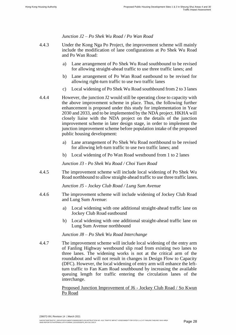
Junction J2 – Po Shek Wu Road / Po Wan Road
4.4.3 Under the Kong Nga Po Project, the improvement scheme will mainly include the modification of lane configurations at Po Shek Wu Road and Po Wan Road:
a) Lane arrangement of Po Shek Wu Road southbound to be revised for allowing straight-ahead traffic to use three traffic lanes; and
b) Lane arrangement of Po Wan Road eastbound to be revised for allowing right-turn traffic to use two traffic lanes
c) Local widening of Po Shek Wu Road southbound from 2 to 3 lanes
4.4.4 However, the junction J2 would still be operating close to capacity with the above improvement scheme in place. Thus, the following further enhancement is proposed under this study for implementation in Year 2030 and 2033, and to be implemented by the NDA project. HKHA will closely liaise with the NDA project on the details of the junction improvement scheme in later design stage, in order to implement the junction improvement scheme before population intake of the proposed public housing development:
a) Lane arrangement of Po Shek Wu Road northbound to be revised for allowing left-turn traffic to use two traffic lanes; and
b) Local widening of Po Wan Road westbound from 1 to 2 lanes
Junction J3 - Po Shek Wu Road / Choi Yuen Road
4.4.5 The improvement scheme will include local widening of Po Shek Wu Road northbound to allow straight-ahead traffic to use three traffic lanes.
Junction J5 - Jockey Club Road / Lung Sum Avenue
4.4.6 The improvement scheme will include widening of Jockey Club Road and Lung Sum Avenue:
a) Local widening with one additional straight-ahead traffic lane on Jockey Club Road eastbound
b) Local widening with one additional straight-ahead traffic lane on Lung Sum Avenue northbound
Junction J8 – Po Shek Wu Road Interchange
4.4.7 The improvement scheme will include local widening of the entry arm of Fanling Highway westbound slip road from existing two lanes to three lanes. The widening works is not at the critical arm of the roundabout and will not result in changes in Design Flow to Capacity (DFC). However, the local widening of entry arm will enhance the left-turn traffic to Fan Kam Road southbound by increasing the available queuing length for traffic entering the circulation lanes of the interchange.
Proposed Junction Improvement of J6 - Jockey Club Road / So Kwun Po Road

Hong Kong Housing Authority Proposed Public Housing Development Sites 1 & 2 in Sheung Shui Areas 4 and 30
Traffic Impact Assessment
236072-09 | Revision 14 | March 2021
\\HKGNTS69\TRAFFIC_GROUP\DOCUMENT\236000\236072-09 INSTRUCTION NO. A19, TRAFFIC IMPACT ASSESSMENT FOR SITES 1 & 2 AT FANLING SHEUNG SHUI AREA
30\09 REPORTS\TIA\FORMAL\14TH FORMAL (02102020)\FR_REV13C.DOCX
Page 29
4.4.8 Junction improvement schemes at J6 - Jockey Club Road / So Kwun Po Road are being reviewed and explored under NDA, which includes:
a) Lane arrangement of the Jockey Club Road northbound to be revised for allowing left-turn traffic to use two traffic lanes; and
b) Method-of-Control (MOC) to be revised for minimizing / optimizing the intergreen time
c) Lane arrangement of Ma Sik Road southbound to be revised for allowing three traffic lanes for vehicles to travel straight ahead
d) Local widening of So Kwun Po Road southbound from 2 to 3 lanes
4.4.9 However, the junction J6 would still be operating over capacity with the above improvement scheme in place in both Year 2030 and 2033. Thus, the following further enhancement is proposed under this study for implementation:
a) Local widening with one additional straight-ahead traffic lane on So Kwun Po Road northbound
b) Local widening of Ma Sik Road northbound from 2 to 3 lanes
4.4.10 HKHA will closely liaise with the NDA project on the details and implementation of the junction improvement scheme.
4.4.11 The general layout of the proposed junction improvement scheme is shown in Appendix B.
4.4.12 With the above proposed junction improvement schemes in place, the results of junction capacity assessment of Junctions J2, J3, J5, J6 and J8 are shown in Table 4.12 below:
Table 4.12 Summary of Junction Performance – With Proposed
Junction Improvement Schemes in Place
Junction (1) Type
Junction Performance (2)
Year 2030 Year 2033
Reference Case Design Case Reference Case Design Case
AM PM AM PM AM PM AM PM
J2 Po Shek Wu Road /
Po Wan Road Signal 22% 17% 17% 15% 19% 13% 14% 11%
J3 Po Shek Wu Road /
Choi Yuen Road Signal 18% 17% 15% 13% 16% 15% 13% 11%
J5 Jockey Club Road /
Lung Sum Avenue Signal 21% 53% 18% 51% 19% 51% 16% 49%
J6 Jockey Club Road /
So Kwun Po Road Signal 12% 27% 11% 27% 10% 25% 9% 25%
J8 Po Shek Wu Road
Interchange (3)
Round
about 0.78 0.75 0.82 0.77 0.80 0.76 0.83 0.78
Notes: (1) Junction Improvement Scheme had been incorporated in both reference and
design case; and (2) Figures shown represent “Reserve Capacity” (RC) for the signal controlled
junctions and “Design Flow to Capacity” (DFC) ratio for the roundabout. A
signal-controlled junction with a reserve capacity (RC) of 0% implies that it is

Hong Kong Housing Authority Proposed Public Housing Development Sites 1 & 2 in Sheung Shui Areas 4 and 30
Traffic Impact Assessment
236072-09 | Revision 14 | March 2021
\\HKGNTS69\TRAFFIC_GROUP\DOCUMENT\236000\236072-09 INSTRUCTION NO. A19, TRAFFIC IMPACT ASSESSMENT FOR SITES 1 & 2 AT FANLING SHEUNG SHUI AREA
30\09 REPORTS\TIA\FORMAL\14TH FORMAL (02102020)\FR_REV13C.DOCX
Page 30
operating at capacity while a negative RC suggests that the junction is overloaded.
RC >= 15 % implies that the signal-controlled junction is operating satisfactory.
For roundabout, the performance indicator is the DFC. DFC ratio of 1.00 indicates
continual queuing and could not be considered acceptable. A DFC ratio of 0.85,
indicating that queuing would theoretically be avoided in 85% of cases, can be
considered reasonable. A DFC of 0.70 indicates that queuing will be avoided in
0.95 of cases. (3) The proposed widening works is not at the critical arm of the roundabout and
thus does not result in changes in Design Flow to Capacity (DFC).
4.4.13 With the proposed junction improvement scheme in place, performance of all junction would be improved with RC higher than those before the proposed housing developments in place (i.e. Reference Case as presented in Tables 4.8 and 4.10). HKHA will closely liaise with the relevant government departments on the details of the junction improvement scheme in later design stage, in order to implement the junction improvement scheme before population intake of the proposed public housing development. HKHA will consider taking up the junction improvement works at J2 and J3 as described in Section 4.4.4 and 4.4.5 respectively, in which the traffic generated/attracted by the proposed housing development have direct impact to these junctions, by government funding in case the junction improvement works undertaken by others could not meet HKHA's population intake of the proposed housing development.
4.4.14 The proposed road improvement works under Kong Nga Po project by CEDD would be implemented under NDA project by CEDD as confirmed by CEDD.
4.5 Proposed Improvement Scheme at Po Shek Wu Road
4.5.1 To further enhance the vehicular accessibility in the vicinity of the
proposed housing sites and alleviate the existing traffic queue problem
on Po Shek Wu Road southbound, an improvement scheme at Po Shek
Wu Road Southbound is shown in Figure 9. The improvement scheme
consists of widening the Po Shek Wu Road Southbound (Section
between Fanling Highway and Choi Yuen Road) with 1 no. of
additional lane.
4.5.2 As mentioned in Section 2.4, Po Shek Wu Road Interchange is
currently operating close to its capacity, mainly due to high traffic
volume from Po Shek Wu Road Southbound approach arm. Due to the
short available queuing length for vehicles waiting to enter the
interchange, the left-turn traffic to Fanling Highway Eastbound would
frequently be hindered from the vehicle queue at the interchange.
Vehicles would easily queue up along Po Shek Wu Road Southbound,
reaching Choi Yuen Road (i.e. Junction J3 - Po Shek Wu Road / Choi
Yuen Road), and further extend to Po Wan Road (i.e. Junction J2 - Po
Shek Wu Road / Po Wan Road) at intermittent critical condition.
4.5.3 The proposed improvement scheme will widen Po Shek Wu Road
Southbound to 3 nos. of lanes all the way. This could accommodate an

Hong Kong Housing Authority Proposed Public Housing Development Sites 1 & 2 in Sheung Shui Areas 4 and 30
Traffic Impact Assessment
236072-09 | Revision 14 | March 2021
\\HKGNTS69\TRAFFIC_GROUP\DOCUMENT\236000\236072-09 INSTRUCTION NO. A19, TRAFFIC IMPACT ASSESSMENT FOR SITES 1 & 2 AT FANLING SHEUNG SHUI AREA
30\09 REPORTS\TIA\FORMAL\14TH FORMAL (02102020)\FR_REV13C.DOCX
Page 31
additional lane with approximately 300m in length. The total available
length of traffic lanes for queueing at existing condition and after
implementation of the proposed improvement scheme are summarized
in Table 4.13.
Table 4.13 Summary of Available Length of Traffic Lanes for
Queuing of Po Shek Wu Road Southbound (Section
between Po Shek Wu Road Interchange and Choi Yuen
Road)
Location
Available Length of Traffic Lanes for Queuing (m)
Existing
(2 lanes)
With Possible Improvement Scheme in Place
(3 lanes)
Po Shek Wu Road Southbound
(Section between Po Shek Wu Road
Interchange and Choi Yuen Road)
~600 ~850
4.5.4 The traffic entering the interchange could utilize either middle or right
lane, and the traffic to Fanling Highway Eastbound can enter the
dedicated left-turn lane by utilizing the additional lane at Po Shek Wu
Road Southbound. It is anticipated that the traffic condition at Po Shek
Wu Road Southbound could be improved by minimizing the weaving
movements and increasing the queuing length.
4.5.5 CEDD Civil Engineering Office will undertake the improvement of Po Shek Wu Road. The implementation details, design and construction responsibility will be further investigated in the later design stage.
4.5.6 With the proposed Po Shek Wu Road widening scheme in place, the results of link capacity assessment of Link L1 – Po Shek Wu Road southbound (Section between Choi Yuen Road and Fanling Highway) for Year 2030 and 2033 are summarized in Table 4.14 and 4.15 respectively.
Table 4.14 Summary of Road Link Performance in Year 2030 – With
Proposed Po Shek Wu Road Widening Schemes in Place
Road Links Direction Capacity
(pcu/hr) (1)
Road Link Performance
Reference Case Design Case
Flow (pcu/hr) V/C Ratio (2) Flow (pcu/hr) V/C Ratio (2)
AM PM AM PM AM PM AM PM
L1
Po Shek Wu Road –
Section between Choi
Yuen Road and
Fanling Highway
SB
Before
Widening
3,000
1,855 1,980 0.62 0.66 1,910 2,045 0.64 0.68
SB
After
Widening
4,700
1,855 1,980 0.39 0.42 1,910 2,045 0.41 0.44
Note: (1) Road capacity is defined in accordance to STM Model and TPDM Volume 2
Chapter 2.4 Table 2.4.1.1 by converting the vehicles to pcu for analysis; (2) A V/C ratio of 0.7 might infer adequate operating conditions, the effect of
junctions or traffic signals both within and at the end of the road link may be such
that the design flow could never be achieved in practice, and the link might be
severely congested well before a V/C ratio of 1.0 is reached.

Hong Kong Housing Authority Proposed Public Housing Development Sites 1 & 2 in Sheung Shui Areas 4 and 30
Traffic Impact Assessment
236072-09 | Revision 14 | March 2021
\\HKGNTS69\TRAFFIC_GROUP\DOCUMENT\236000\236072-09 INSTRUCTION NO. A19, TRAFFIC IMPACT ASSESSMENT FOR SITES 1 & 2 AT FANLING SHEUNG SHUI AREA
30\09 REPORTS\TIA\FORMAL\14TH FORMAL (02102020)\FR_REV13C.DOCX
Page 32
Table 4.15 Summary of Road Link Performance in Year 2033 – With
Proposed Po Shek Wu Road Widening Schemes in Place
Road Links Direction Capacity
(pcu/hr) (1)
Road Link Performance
Reference Case Design Case
Flow (pcu/hr) V/C Ratio (2) Flow (pcu/hr) V/C Ratio (2)
AM PM AM PM AM PM AM PM
L1
Po Shek Wu Road –
Section between Choi
Yuen Road and
Fanling Highway
SB
Before
Widening
3,000
1,885 2,010 0.63 0.67 1,940 2,075 0.65 0.69
SB
After
Widening
4,700
1,885 2,010 0.40 0.43 1,940 2,075 0.41 0.44
Note: (1) Road capacity is defined in accordance to STM Model and TPDM Volume 2
Chapter 2.4 Table 2.4.1.1 by converting the vehicles to pcu for analysis; (2) A V/C ratio of 0.7 might infer adequate operating conditions, the effect of
junctions or traffic signals both within and at the end of the road link may be such
that the design flow could never be achieved in practice, and the link might be
severely congested well before a V/C ratio of 1.0 is reached.
4.5.7 It is revealed that the widening work will greatly improve the link performance (i.e. reducing the V/C ratio of Po Shek Wu Road southbound from 0.69 to 0.44 during the most critical 2033 design case PM peak).
4.5.8 It is worth to note that the future Po Shek Wu Interchange Improvement which provides a flyover to allow the right turning traffic from Po Shek Wu Road southbound to Fanling Highway westbound and bypass the existing Po Shek Wu Interchange. The traffic flow on Po Shek Wu Road southbound, between Choi Yuen Road and Fanling Highway, will be reduced and the traffic queue problem is expected to be further alleviated.
4.6 Other Improvement Schemes to Existing Interchanges
4.6.1 Besides the future Po Shek Wu Interchange Improvement, it is noted
that the government is planning to carry out a feasibility study for a new
infrastructure connecting the northern and southern side of Fanling
Highway. The new North South Link will be able to divert traffic and
relieve the traffic condition in the existing interchanges, i.e. Junctions
J7 – So Kwun Po Road Interchange and J8 –Po Shek Wu Road
Interchange.
4.6.2 Table 4.16 summarizes the improvement scheme as proposed amongst
different concurrent projects.

Hong Kong Housing Authority Proposed Public Housing Development Sites 1 & 2 in Sheung Shui Areas 4 and 30
Traffic Impact Assessment
236072-09 | Revision 14 | March 2021
\\HKGNTS69\TRAFFIC_GROUP\DOCUMENT\236000\236072-09 INSTRUCTION NO. A19, TRAFFIC IMPACT ASSESSMENT FOR SITES 1 & 2 AT FANLING SHEUNG SHUI AREA
30\09 REPORTS\TIA\FORMAL\14TH FORMAL (02102020)\FR_REV13C.DOCX
Page 33
Table 4.16 Summary of Junction Improvement Schemes
Junction (1) Type Description Proposed
by Project
Anticipated
Implementation
Schedule
Drawing
No. in
Appendix
B (2)
J2 Po Shek
Wu Road/
Po Wan
Road
Signal ➢ Lane arrangement of Po
Shek Wu Road southbound
to be revised for allowing
straight-ahead traffic to use
three traffic lanes
➢ Lane arrangement of Po
Wan Road eastbound to be
revised for allowing right-turn
traffic to use two traffic lanes
Kong Nga
Po
To tie in with the
programme of phased
population intake of
NDA. The current
target of completion is
2023.
B1
➢ Lane arrangement of Po
Shek Wu Road northbound
to be revised for allowing left-
turn traffic to use two traffic
lanes; and
➢ Local widening of Po Wan
Road westbound from 1 to 2
lanes
Sheung
Shui Areas
4 and 30
Sites 1 &2
(to be
incorporated
in Kong Nga
Po)
To tie in with the
programme of phased
population intake of
NDA. The current
target of completion is
2023.
B1
J3 Po Shek
Wu Road/
Choi Yuen
Road
Signal ➢ Lane arrangement of the
Choi Yuen Road westbound
to be revised for providing
two left-turn lanes
Queen’s Hill
Already completed
under Queen’s Hill
Project
A1
➢ local widening of Po Shek
Wu Road northbound to
allow straight-ahead traffic to
use three traffic lanes
Kong Nga
Po
To tie in with the
programme of phased
population intake of
NDA. The current
target of completion is
2023.
B3
➢ Po Shek Wu Interchange
Improvement which provides
a flyover to allow the right
turning traffic from Po Shek
Wu Road southbound to
Fanling Highway westbound
to bypass the existing Po
Shek Wu Interchange
➢ Po Shek Wu Road
southbound would be
narrowed from 5 lanes to 4
lanes
NDA To tie in with the
programme of phased
population intake of
NDA. The current
target of completion is
2029.
A2
J5
Jockey
Club Road/
Signal ➢ Lane arrangement of the
Lung Sum Avenue
northbound/southbound to
Queen’s Hill
Year 2021 A3

Hong Kong Housing Authority Proposed Public Housing Development Sites 1 & 2 in Sheung Shui Areas 4 and 30
Traffic Impact Assessment
236072-09 | Revision 14 | March 2021
\\HKGNTS69\TRAFFIC_GROUP\DOCUMENT\236000\236072-09 INSTRUCTION NO. A19, TRAFFIC IMPACT ASSESSMENT FOR SITES 1 & 2 AT FANLING SHEUNG SHUI AREA
30\09 REPORTS\TIA\FORMAL\14TH FORMAL (02102020)\FR_REV13C.DOCX
Page 34
Junction (1) Type Description Proposed
by Project
Anticipated
Implementation
Schedule
Drawing
No. in
Appendix
B (2)
Lung Sum
Avenue
be revised for allowing
straight-ahead traffic to use
two traffic lanes
➢ Widening the Lung Sum
Avenue northbound by
narrowing the central median
of Lung Sum Avenue
(Queen’s Hill
Infrastructure works
undertaken by CEDD)
➢ Local widening with one
additional straight-ahead
traffic lane on Jockey Club
Road eastbound
➢ Local widening with one
additional straight-ahead
traffic lane on Lung Sum
Avenue northbound
Kong Nga
Po
To tie in with the
programme of phased
population intake of
NDA. The current
target of completion is
2023.
B4
J6 Jockey
Club Road/
So Kwun
Po Road
Signal ➢ Lane arrangement of the
Jockey Club Road
northbound to be revised for
allowing left turn traffic to use
two traffic lanes
➢ Method-of-Control (MOC) to
be revised for minimizing/
optimizing the intergreen
time
➢ Lane arrangement of Ma Sik
Road southbound to be
revised for allowing three
traffic lanes for vehicles to
travel straight ahead
➢ Local widening of So Kwun
Po Road southbound from 2
to 3 lanes
NDA
To tie in with the
programme of phased
population intake of
NDA. The current
target of completion is
2023.
B5
➢ Local widening with one
additional straight-ahead
traffic lane on So Kwun Po
Road northbound
➢ Local widening of Ma Sik
Road northbound from 2 to 3
lanes
Sheung
Shui Areas
4 and 30
Sites 1 &2
(to be
incorporated
in NDA)
To tie in with the
programme of phased
population intake of
NDA. The current
target of completion is
2023.
B5
J7
So Kwun
Po Road
Interchange
Roundabout ➢ Local widening of
southbound approach arm of
So Kwun Po Road for a
smoother entrance to the
elevated roundabout
Queen’s Hill Year 2021
(Queen’s Hill
Infrastructure works
undertaken by CEDD)
A4

Hong Kong Housing Authority Proposed Public Housing Development Sites 1 & 2 in Sheung Shui Areas 4 and 30
Traffic Impact Assessment
236072-09 | Revision 14 | March 2021
\\HKGNTS69\TRAFFIC_GROUP\DOCUMENT\236000\236072-09 INSTRUCTION NO. A19, TRAFFIC IMPACT ASSESSMENT FOR SITES 1 & 2 AT FANLING SHEUNG SHUI AREA
30\09 REPORTS\TIA\FORMAL\14TH FORMAL (02102020)\FR_REV13C.DOCX
Page 35
Junction (1) Type Description Proposed
by Project
Anticipated
Implementation
Schedule
Drawing
No. in
Appendix
B (2)
➢ New infrastructure to connect
the northern and southern
side of Fanling Highway
Subject to
further Gov.
study
Nil Nil
J8 Po Shek
Wu Road
Interchange
Roundabout ➢ Local widening of
southbound approach arm of
Po Shek Wu Road to 10m to
have two traffic lanes when
approaching the roundabout
Queen’s Hill
2021
(Queen’s Hill Infrastructure works undertaken by CEDD)
A5
➢ Local widening section of
southbound of Po Shek Wu
Road between Choi Yuen
Road and Po Shek Wu Road
Interchange
Sheung
Shui Areas
4 and 30
Sites 1 &2
Year 2023/24
(undertaken by CEDD
Civil Engineering
Office)
Nil
➢ local widening of the entry
arm of Fanling Highway
westbound slip road from
existing two lanes to three
lanes
Kong Nga
Po
To tie in with the
programme of phased
population intake of
NDA. The current
target of completion is
2023.
B6
➢ Po Shek Wu Interchange
Improvement which provides
a flyover to allow the right
turning traffic from Po Shek
Wu Road southbound to
Fanling Highway westbound
and bypass the existing Po
Shek Wu Interchange
NDA To tie in with the
programme of phased
population intake of
NDA. The current
target of completion is
2029.
A2
Notes: (1) Please refer to Figure 1 for the location of the assessed junctions. (2) The general arrangement of junction improvement schemes are shown in
Appendix A and B. (3) The proposed road improvement works under Kong Nga Po project by CEDD
would be implemented under NDA project by CEDD as confirmed by CEDD.
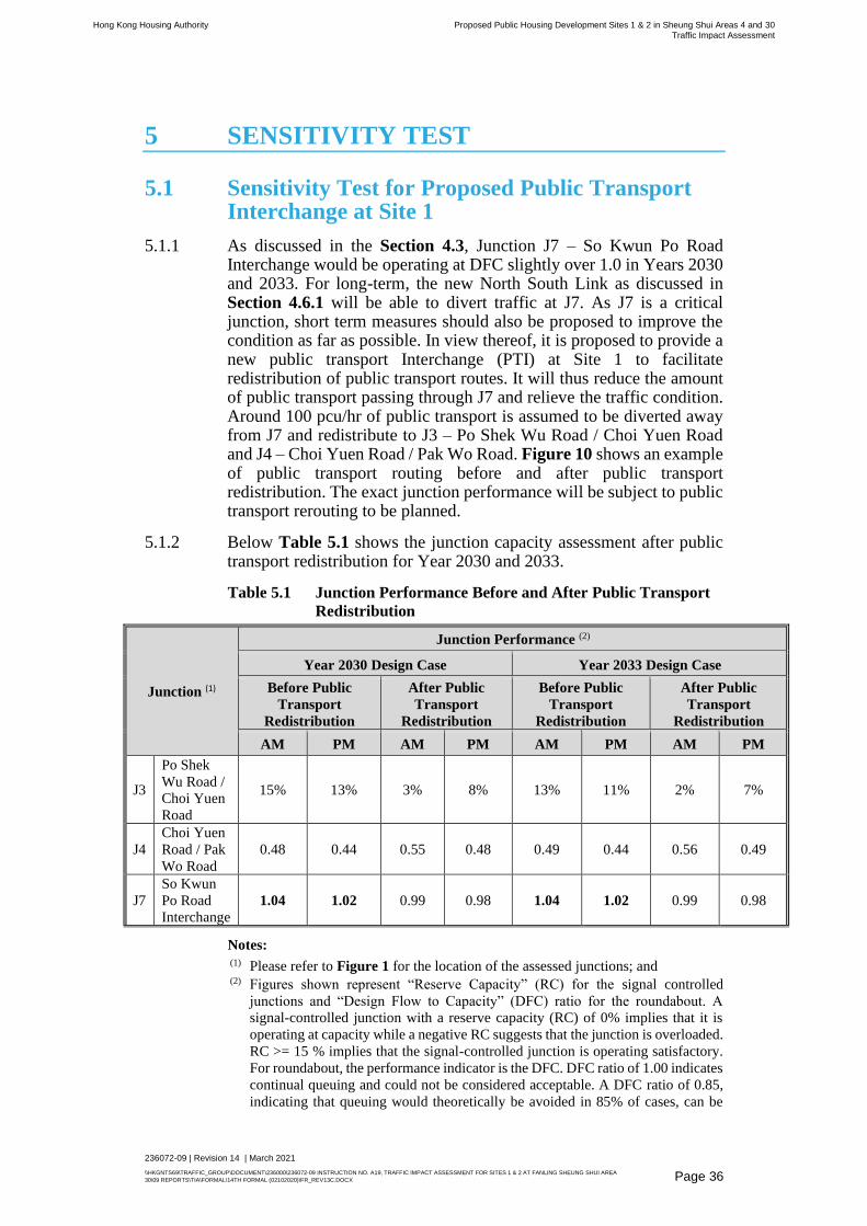
Hong Kong Housing Authority Proposed Public Housing Development Sites 1 & 2 in Sheung Shui Areas 4 and 30
Traffic Impact Assessment
236072-09 | Revision 14 | March 2021
\\HKGNTS69\TRAFFIC_GROUP\DOCUMENT\236000\236072-09 INSTRUCTION NO. A19, TRAFFIC IMPACT ASSESSMENT FOR SITES 1 & 2 AT FANLING SHEUNG SHUI AREA
30\09 REPORTS\TIA\FORMAL\14TH FORMAL (02102020)\FR_REV13C.DOCX
Page 36
5 SENSITIVITY TEST
5.1 Sensitivity Test for Proposed Public Transport Interchange at Site 1
5.1.1 As discussed in the Section 4.3, Junction J7 – So Kwun Po Road Interchange would be operating at DFC slightly over 1.0 in Years 2030 and 2033. For long-term, the new North South Link as discussed in Section 4.6.1 will be able to divert traffic at J7. As J7 is a critical junction, short term measures should also be proposed to improve the condition as far as possible. In view thereof, it is proposed to provide a new public transport Interchange (PTI) at Site 1 to facilitate redistribution of public transport routes. It will thus reduce the amount of public transport passing through J7 and relieve the traffic condition. Around 100 pcu/hr of public transport is assumed to be diverted away from J7 and redistribute to J3 – Po Shek Wu Road / Choi Yuen Road and J4 – Choi Yuen Road / Pak Wo Road. Figure 10 shows an example of public transport routing before and after public transport redistribution. The exact junction performance will be subject to public transport rerouting to be planned.
5.1.2 Below Table 5.1 shows the junction capacity assessment after public transport redistribution for Year 2030 and 2033.
Table 5.1 Junction Performance Before and After Public Transport
Redistribution
Junction (1)
Junction Performance (2)
Year 2030 Design Case Year 2033 Design Case
Before Public
Transport
Redistribution
After Public
Transport
Redistribution
Before Public
Transport
Redistribution
After Public
Transport
Redistribution
AM PM AM PM AM PM AM PM
J3
Po Shek
Wu Road /
Choi Yuen
Road
15% 13% 3% 8% 13% 11% 2% 7%
J4
Choi Yuen
Road / Pak
Wo Road
0.48 0.44 0.55 0.48 0.49 0.44 0.56 0.49
J7
So Kwun
Po Road
Interchange
1.04 1.02 0.99 0.98 1.04 1.02 0.99 0.98
Notes: (1) Please refer to Figure 1 for the location of the assessed junctions; and (2) Figures shown represent “Reserve Capacity” (RC) for the signal controlled
junctions and “Design Flow to Capacity” (DFC) ratio for the roundabout. A
signal-controlled junction with a reserve capacity (RC) of 0% implies that it is
operating at capacity while a negative RC suggests that the junction is overloaded.
RC >= 15 % implies that the signal-controlled junction is operating satisfactory.
For roundabout, the performance indicator is the DFC. DFC ratio of 1.00 indicates
continual queuing and could not be considered acceptable. A DFC ratio of 0.85,
indicating that queuing would theoretically be avoided in 85% of cases, can be

Hong Kong Housing Authority Proposed Public Housing Development Sites 1 & 2 in Sheung Shui Areas 4 and 30
Traffic Impact Assessment
236072-09 | Revision 14 | March 2021
\\HKGNTS69\TRAFFIC_GROUP\DOCUMENT\236000\236072-09 INSTRUCTION NO. A19, TRAFFIC IMPACT ASSESSMENT FOR SITES 1 & 2 AT FANLING SHEUNG SHUI AREA
30\09 REPORTS\TIA\FORMAL\14TH FORMAL (02102020)\FR_REV13C.DOCX
Page 37
considered reasonable. A DFC of 0.70 indicates that queuing will be avoided in
0.95 of cases.
5.1.3 J7 will be improved with DFC reduced from 1.04 to 0.99 at the critical AM peak of Year 2030 and 2033, while J3 and J4 will still be operating within capacity, after public transport redistribution.
5.1.4 It is suggested to conduct a comprehensive review when the traffic condition becomes stable after commissioning of the Lung Shan Tunnel which will commission in end 2018 and cause changes in the traffic pattern in Fanling/Sheung Shui.
5.2 Sensitivity Test on the Programme Slippage of Major Improvement Works
5.2.1 This sensitivity test will investigate the impact on the surrounding road network in case of slippage of the major improvement works, i.e. Fanling Bypass (Eastern Section), for the 2030 Design Case Scenario. Other local junction improvement schemes considered for the 2030 Design Case Scenario as stated in Table 4.16 are scheduled to be completed by Year 2023/24, which are unlikely to be postponed beyond the population intake of the subject development. Therefore, the local junction improvement schemes are assumed to be in place in this sensitivity test. The sensitivity test also considers the public transport redistribution as described in Section 5.1.
5.2.2 The sensitivity test scenario will exclude Fanling Bypass (Eastern Section) from the Base Design Case Scenario to reflect any programme slippage. Fanling North NDA (Advance Phase) will also be excluded.
5.2.3 Table 5.2 compares the assumptions considered in the Base Design Case Scenario and in the sensitivity analysis.
Table 5.2 Major Assumptions for Sensitivity Test Scenarios
Test
Land Use Planning Assumptions Transport Infrastructure Assumptions
Sheung
Shui
Area 30
Fanling
North
NDA
(Advance
Phase)
Fanling
North NDA
(Remaining
Phase)
Fanling
Bypass
(Eastern
Section)
Fanling Bypass
(Western Section)
and associated
road works
Other infras-tructures
in Remain-ing Phase of NDA
(including Po Shek Wu Flyover,
Fanling Highway widening, and
Fanling Bypass Western Section )
Base Design
Case Scenario
Sensitivity
Test Scenario
5.2.4 The above sensitivity test scenario was also reviewed in the Report on
Traffic and Transport Impact Assessment Review (August 2018) under
Agreement No. CE 13/2014 (CE) Development of Kwu Tung North
and Fanling North New Development Areas, Phase 1 Design and
Construction (i.e. Test 6 under Section 4.5 of the aforesaid report). It is
revealed that all key junctions in Sheung Shui area will still be operating
with DFC < 1.0 or RC > 0% and considered acceptable.
Hong Kong Housing Authority Proposed Public Housing Development Sites 1 & 2 in Sheung Shui Areas 4 and 30
Traffic Impact Assessment
236072-09 | Revision 14 | March 2021
\\HKGNTS69\TRAFFIC_GROUP\DOCUMENT\236000\236072-09 INSTRUCTION NO. A19, TRAFFIC IMPACT ASSESSMENT FOR SITES 1 & 2 AT FANLING SHEUNG SHUI AREA
30\09 REPORTS\TIA\FORMAL\14TH FORMAL (02102020)\FR_REV13C.DOCX
Page 38
6 PEDESTRIAN TRAFFIC IMAPCT ASSESSMENT
6.1 Existing Pedestrian Conditions
6.1.1 Pedestrian count surveys were conducted on normal weekdays in September 2016 / February & April 2017 at selected locations during the periods 0700-1000 and 1700-2000 hours. These locations of the surveyed pedestrian facilities are detailed in Figure 11 and summarized in Table 6.1.
Table 6.1 Critical Pedestrian Facilities
Index (1) Type
I Footpath
K Footbridge
L Footbridge
M Staircase
O Footpath
Q Footpath
R Subway
S Subway
T Staircase
AE Footbridge
AF Staircase
AH Footpath
AI Staircase
AK Footbridge
AL Staircase
AM Footbridge
AN Footpath
AO Staircase
AT Footbridge
BA Footpath
BB Footpath
BC Footpath
BD Footpath
BF Crossing
BG Footpath
Note: (1) Refer to Figure 11 for the location of the assessed pedestrian facilities.
6.1.2 It was observed that the peak pedestrian period was occurred in the morning peak during 0830 – 0930 and evening peak during 1745 - 1845. ‘Level of Service’ and “volume to capacity ratio (V/C)” assessment have been undertaken.

Hong Kong Housing Authority Proposed Public Housing Development Sites 1 & 2 in Sheung Shui Areas 4 and 30
Traffic Impact Assessment
236072-09 | Revision 14 | March 2021
\\HKGNTS69\TRAFFIC_GROUP\DOCUMENT\236000\236072-09 INSTRUCTION NO. A19, TRAFFIC IMPACT ASSESSMENT FOR SITES 1 & 2 AT FANLING SHEUNG SHUI AREA
30\09 REPORTS\TIA\FORMAL\14TH FORMAL (02102020)\FR_REV13C.DOCX
Page 39
Level of Service (LOS)
6.1.3 ‘Level of Service’ (LOS) analysis of the existing pedestrian facilities was carried out based on the definitions presented in the Highways Capacity Manual 2000. This follows the approach currently being recommended by Transport Department. In general, LOS C and D are typical values and LOS A and B would provide a very good LOS. At a LOS of A, pedestrians basically move in desired paths without altering their movements in response to other pedestrians. Walking speeds are freely selected and conflicts between pedestrians are unlikely. At a LOS of B, pedestrians would continue to freely select their own walking speed, can bypass slower pedestrians, and avoid crossing conflicts with others. At a LOS of C, pedestrians are restricted in selecting walking speed and in bypassing other pedestrians. A LOS of D would represent a further deterioration of the pedestrian movements but would still provide reasonable fluid flow. At a LOS of E or lower, it was determined that mitigation measures or improvement schemes should be considered to achieve a LOS of D or better. For the purposes of this pedestrian impact assessment, a LOS of C or above would be considered acceptable while a LOS of D would be marginally acceptable. Table 6.2 shows the various LOS ‘quantified’ in terms of pedestrian flow rates.
Table 6.2 Level of Service (LOS) for Walkway
LOS Flow rate
(ped/min/m) Description
A <= 16 Pedestrians move in desired paths. Walking speeds are freely selected and
conflicts between pedestrians are unlikely.
B 16 - 23
Sufficient space is provided for pedestrians to freely select walking speeds,
to bypass other pedestrians and to avoid crossing conflicts with others.
Pedestrians become aware of other pedestrians.
C 23 - 33
Sufficient space is available to select normal walking speeds and to bypass
other pedestrians in unidirectional stream. Minor conflicts will occur in
reverse direction or crossing movements.
D 33 - 49
Freedom to select individual walking speeds and bypass other pedestrians
is restricted. Probability of conflicts is high in crossing or reverse-flow
movements. LOS provides reasonable fluid flow, however, friction and
interactions between pedestrians are likely to occur.
E 49 - 75
All pedestrians would have normal walking speeds restricted. Space is
insufficient to pass over slower pedestrians. Cross and reverse movements
are possible only with extreme difficulties. Design volumes approach the
limit of walking capacity.
F > 75
Walking speeds are severely restricted. Forward progress is made by
shuffling. Cross and reverse movements are virtually impossible. Space is
more characteristic of queued pedestrians than of moving pedestrian
streams.

Hong Kong Housing Authority Proposed Public Housing Development Sites 1 & 2 in Sheung Shui Areas 4 and 30
Traffic Impact Assessment
236072-09 | Revision 14 | March 2021
\\HKGNTS69\TRAFFIC_GROUP\DOCUMENT\236000\236072-09 INSTRUCTION NO. A19, TRAFFIC IMPACT ASSESSMENT FOR SITES 1 & 2 AT FANLING SHEUNG SHUI AREA
30\09 REPORTS\TIA\FORMAL\14TH FORMAL (02102020)\FR_REV13C.DOCX
Page 40
6.1.4 Based on the pedestrian count surveys, Table 6.3 details the results of the LOS assessment.
Table 6.3 Existing (2016/2017) Pedestrian Facilities Assessment
Results
Location (1)
Type
Clear
Width
(m)
Capacity
(ppm/m) (2)
Pedestrian
Demand (pph)
Flow Rate
(ppm/m) (3) LOS V/C Ratio
AM PM AM PM AM PM AM PM
I(4) Footpath 2.2 50 1,210 1,145 11.2 10.6 A A 0.22 0.21
K Footbridge 3.5 50 1,260 1,270 8.4 8.5 A A 0.17 0.17
L Footbridge 3.5 50 1,380 1,460 9.2 9.7 A A 0.18 0.19
M Staircase 3.0 40 160 315 1.3 2.6 A A 0.03 0.07
O(4) Footpath 3.5 50 715 730 3.8 3.9 A A 0.08 0.08
Q Footpath 1.2 50 45 10 0.9 0.2 A A 0.02 0.00
R Footpath 2.1 50 385 595 5.8 9.0 A A 0.12 0.18
S Subway 2.6 50 385 620 4.0 6.5 A A 0.08 0.13
T Staircase 3.0 40 10 0 0.1 0.0 A A 0.00 0.00
AE(4) Footbridge 5.3 50 5,135 8,560 19.9 33.2 B D 0.40 0.66
AF Staircase 5.2 40 7,400 6,785 29.4 26.9 C C 0.73 0.67
AH Footpath 6.5 50 3,080 5,730 8.9 16.5 A B 0.18 0.33
AI Staircase 2.0 40 710 995 11.8 16.6 A B 0.30 0.41
AK Footbridge 4.5 50 1,220 2,315 5.8 11.0 A A 0.12 0.22
AL Staircase 3.4 40 35 145 0.2 1.0 A A 0.01 0.03
AM Footbridge 3.5 50 785 955 5.2 6.4 A A 0.10 0.13
AN(4) Footpath 3.5 50 2,615 3,655 14.1 19.7 A B 0.28 0.39
AO Staircase 3.0 40 665 755 5.5 6.3 A A 0.14 0.16
AT(4) Footbridge 3.2 50 3,995 2,855 30.3 21.6 C B 0.61 0.43
BA Footpath 3.0 40 1,000 795 8.3 6.6 A A 0.21 0.17
BB Footpath 3.5 50 800 640 4.8 3.8 A A 0.10 0.08
BC Footpath 2.5 50 480 385 4.4 3.6 A A 0.09 0.07
BD Footpath 3.5 50 385 495 2.3 2.9 A A 0.05 0.06
BF Crossing 4.6 12.4 2,040 3,070 7.4 11.1 - - 0.60 0.90
BG Footpath 3.5 50 905 1,430 5.4 8.5 A A 0.11 0.17
BH(5) Footpath 2.3 50 2,830 3,820 24.8 33.5 C D 0.50 0.67
Notes: (1) Refer to Figure 11 for the location of the assessed pedestrian facilities; (2) Refer to TPDM Vol. 2 Ch. 3 Table 3.7.7.1 for capacity of walkway/ staircase, and
TPDM Vol. 4 Chapter 3 Para 3.2.5.6 for capacity of signalized crossing; (3) Computed based on effective width for footpath/footbridge/staircase, by assuming
0.2m and 0.5m lateral clearance to railing/planter/tree and wall/fence according to
Highway Capacity Manual 2000 Chapter 18 Exhibit 18-1; (4) In view of the reduced surveyed pedestrian flows in Year 2016/2017 at locations
I, O, AE, AN and AT compared with the Year 2014 surveyed pedestrian flows
under the pedestrian assessment of Po Shek Wu Estate, the highest surveyed
pedestrian flows among Year 2014 and Year 2016/2017 are adopted for
conservative assessment purpose, with the aims of taking into account the
fluctuation impacts of the parallel trade activities; and (5) Taking into account of the bus passenger queue and reducing the effective
footpath width by 1m, the flow rate of BH becomes 52.4 ppm/m and 70.7 ppm/m
(i.e LOS E) during AM and PM peak respectively.
6.1.5 As shown in Table 6.3 all existing pedestrian facilities are operating with LOS C or better and V/C ratio <= 1, except for locations AE and BH.

Hong Kong Housing Authority Proposed Public Housing Development Sites 1 & 2 in Sheung Shui Areas 4 and 30
Traffic Impact Assessment
236072-09 | Revision 14 | March 2021
\\HKGNTS69\TRAFFIC_GROUP\DOCUMENT\236000\236072-09 INSTRUCTION NO. A19, TRAFFIC IMPACT ASSESSMENT FOR SITES 1 & 2 AT FANLING SHEUNG SHUI AREA
30\09 REPORTS\TIA\FORMAL\14TH FORMAL (02102020)\FR_REV13C.DOCX
Page 41
6.2 Pedestrian Demand Forecasting
Background Pedestrian Flows and Other Planned/Committed Developments in the Vicinity of Site
6.2.1 Pedestrian flows adopted in this study were primarily based on the existing Year 2016 pedestrian counts undertaken (details refer to Section 6.1). Pedestrian trip generation/attraction for other planned/committed developments in the vicinity of the Sites had been incorporated in the background pedestrian flows, including the following developments:
• Proposed Committed Public Housing Development at Po Shek Wu Estate;
• Proposed Public Housing Development at Po Shek Wu Road, Sheung Shui;
• Proposed Wholesale Conversion into Retail Development from Existing Advanced Technology Centre at No. 2 Choi Fat Street, Sheung Shui;
• Proposed Wholesale Conversion into Office-cum-Retail Building from Existing Industrial Building at No.9 Choi Yuen Road, Sheung Shui;
• Proposed Wholesale Conversion into Retail Development at No. 6 Choi Fai Street, Sheung Shui; and
• Proposed Wholesale Conversion into Office-cum-Retail Building at No. 21 Po Wan Road, Sheung Shui.
6.2.2 The estimated pedestrian trips of these developments have also been reviewed and incorporated into the development of pedestrian forecast, as appropriate. Pedestrian trip generation / attraction by proposed housing development of Po Shek Wu Estate are reference to the HKHA’s Traffic Impact Assessment (TIA) Report for Po Shek Wu Estate. To estimate the pedestrian generation for other planned/committed development in the vicinity of Site, reference has been made to in-house pedestrian survey conducted for the existing public housing developments, office, retail facilities and kindergarten. The trip rates were applied to the development parameters of the planned/committed development to derive the pedestrian trips as shown in Table 6.4.

Hong Kong Housing Authority Proposed Public Housing Development Sites 1 & 2 in Sheung Shui Areas 4 and 30
Traffic Impact Assessment
236072-09 | Revision 14 | March 2021
\\HKGNTS69\TRAFFIC_GROUP\DOCUMENT\236000\236072-09 INSTRUCTION NO. A19, TRAFFIC IMPACT ASSESSMENT FOR SITES 1 & 2 AT FANLING SHEUNG SHUI AREA
30\09 REPORTS\TIA\FORMAL\14TH FORMAL (02102020)\FR_REV13C.DOCX
Page 42
Table 6.4 Trip Generation Rates and Pedestrian Demand for Other
Planned/Committed Developments in the Vicinity of the Sites
Parameter Unit
Trip Rates# Trip Generations (ped/hr)
AM PM AM PM
GEN ATT GEN ATT GEN ATT GEN ATT
Public Housing Development at Po Shek Wu Estate (1)
PRH cum retail facilities (1,160
flats and 790 m2 GFA retail
facilities)
ped/hr/flat 0.742 0.259 0.298 0.614 899 314 361 744
Kindergarten (6 classrooms) ped/hr/classroom 12.020 30.310 2.750 1.000 72 182 17 6
Welfare facilities (3,498m2 GFA)
and multi-function area (396m2
GFA)
expected to serve mainly the Site residents and will only induce minimal pedestrian trips
Public Car Park (221 nos. of spaces) ped/hr/vehicular trip 2 2 2 2 38 70 84 82
Total (Po Shek Wu Estate) 1,009 566 462 832
Public Housing Development at Po Shek Wu Road
SSF cum retail facilities (1,850
flats and 3,000m2 GFA retail
facilities)
ped/hr/flat 0.580 0.120 0.200 0.380 1,073 222 370 703
Kindergarten (6 classrooms) ped/hr/classroom 12.020 30.310 2.750 1.000 72 182 17 6
Total (Public Housing Development at Po Shek Wu Road) 1,145 404 387 709
Proposed Wholesale Conversion into Retail Development from Existing Advanced Technology Centre at No. 2 Choi Fat
Street, Sheung Shui (2)
Retail (12,445 m2 GFA) ped/100m2 GFA 0.000 0.000 2.011 2.132 30 30 250 265
Total (No. 2 Choi Fat Street, Sheung Shui) 30 30 250 265
Proposed Wholesale Conversion into Office-cum-Retail Building from Existing Industrial Building at No.9 Choi Yuen
Road, Sheung Shui (3)
Retail (6,219 m2 GFA) ped/100m2 GFA 0.000 0.000 2.011 2.132 30 30 125 133
Office (21,821 m2 GFA) ped/100m2 GFA 0.222 1.934 1.567 0.266 48 422 342 58
Total (No. 9 Choi Yuen Road, Sheung Shui) 78 452 467 191
Proposed Wholesale Conversion into Retail Development at No. 6 Choi Fai Street, Sheung Shui (4)
Retail (29,821 m2 GFA) ped/100m2 GFA 0.000 0.000 2.011 2.132 30 30 600 636
Total (No. 6 Choi Fai Street, Sheung Shui) 30 30 600 636
Proposed Wholesale Conversion into Office-cum-Retail Building at No. 21 Po Wan Road, Sheung Shui (4)
Retail (2,601 m2 GFA) ped/100m2 GFA 0.000 0.000 2.011 2.132 30 30 52 55
Office (1,676 m2 GFA) ped/100m2 GFA 0.222 1.934 1.567 0.266 4 32 26 4
Total (No. 21 Po Wan Road, Sheung Shui) 34 62 79 60
Note: (1) Trip generation / attraction of Po Shek Wu Estate are reference to HKHA’s TIA Report of Po Shek Wu Estate; (2) Development parameters are reference to Developer’s TIA Report under S.16 Application No. A/FSS/246; (3) Development parameters are reference to Developer’s TIA Report under S.16 Application No. A/FSS/241; (4) Development parameters are reference to the parameters stipulated in TIA Report under S.16 Application No.
A/FSS/241.
# Pedestrian trip rates for public housing development at Po Shek Wu Road and private redevelopment are
reference to in-house pedestrian survey conducted at similar existing SSF, office and retail facilities:
a) SSF – Choi Po Court (No. 2 Choi Yuen Road, Sheung Shui);
b) Office – Office Tower of Landmark North (No. 39 Lung Sum Avenue, Sheung Shui); and
c) Retail – Retail shops in Fanling Town Centre (No.18 Fanling Station Road, Fanling)
For conservative assessment purpose, a nominal pedestrian generation / attraction with 30 ped/hour is assumed
for the retail facilities during AM peak hours.
Pedestrian trip rates for kindergarten school are reference to HKHA’s TIA Report of Po Shek Wu Estate.

Hong Kong Housing Authority Proposed Public Housing Development Sites 1 & 2 in Sheung Shui Areas 4 and 30
Traffic Impact Assessment
236072-09 | Revision 14 | March 2021
\\HKGNTS69\TRAFFIC_GROUP\DOCUMENT\236000\236072-09 INSTRUCTION NO. A19, TRAFFIC IMPACT ASSESSMENT FOR SITES 1 & 2 AT FANLING SHEUNG SHUI AREA
30\09 REPORTS\TIA\FORMAL\14TH FORMAL (02102020)\FR_REV13C.DOCX
Page 43
Development Trip Generations
6.2.3 To estimate the pedestrian generation for the proposed development, reference has been made to in-house pedestrian survey conducted for the existing public housing developments, retail facilities and kindergarten school. The trip rates were applied to the proposed additional number of flats to derive the resident trips. These rates and the estimated pedestrian trips are tabulated in Table 6.5. For the development type of welfare facilities, they are expected to serve mainly the local residents and will only induce minimal pedestrian trips on the walkway network. These development types are therefore excluded from the estimation.
Table 6.5 Trip Generation Rates and Pedestrian Demand for
Proposed Public Housing Development Sites 1 and 2
Parameter Unit
Trip Rates# Trip Generations (ped/hr)
AM PM AM PM
GEN ATT GEN ATT GEN ATT GEN ATT
Public Housing Development at Site 1
Public Housing cum retail facilities (2,088 flats and 395 m2 GFA retail facilities) (1)
ped/hr/flat 0.742 0.259 0.298 0.614 1,704 595 684 1,411
Kindergarten (6 classrooms)
ped/hr/classroom 12.020 30.310 2.750 1.000 72 182 17 6
Welfare facilities (10,513 m2 GFA)
expected to serve mainly the Site residents and will only induce minimal pedestrian trips
Total (Site 1) 1,776 777 701 1,417
Public Housing Development at Site 2
Public Housing cum retail facilities (1,556 flats and 700 m2 GFA retail facilities) (1)
ped/hr/flat 0.742 0.259 0.298 0.614 1,270 443 510 1,051
Total (Site 2) 1,270 443 510 1,051
Note: (1) An additional 10% allowance for the proposed number of flats has been taken into
account.
# Pedestrian trip rates for public housing and kindergarten are reference to HKHA’s
TIA Report of Po Shek Wu Estate.
6.2.4 Trip rates of proposed housing development and kindergarten facilities had also been referenced to the traffic generation survey conducted at the similar development in North District. The traffic generation surveys were undertaken during AM & PM peak hours on a normal weekday. The observed peak traffic generation rates are tabulated in Table 6.6.

Hong Kong Housing Authority Proposed Public Housing Development Sites 1 & 2 in Sheung Shui Areas 4 and 30
Traffic Impact Assessment
236072-09 | Revision 14 | March 2021
\\HKGNTS69\TRAFFIC_GROUP\DOCUMENT\236000\236072-09 INSTRUCTION NO. A19, TRAFFIC IMPACT ASSESSMENT FOR SITES 1 & 2 AT FANLING SHEUNG SHUI AREA
30\09 REPORTS\TIA\FORMAL\14TH FORMAL (02102020)\FR_REV13C.DOCX
Page 44
Table 6.6 Summary on Surveyed Pedestrian Trip Rates at Existing
Public Housing Development and Kindergartens in North
District
Development AM Peak PM Peak
Generation Attraction Generation Attraction
Public Housing cum Retail Facilities
Wah Ming Estate – 5,340 flats
(ped/hr/flat) (1) 0.523 0.164 0.159 0.429
Ching Ho Estate – 7,200 flats
(ped/hr/flat) (1) 0.550 0.187 0.176 0.496
Kindergarten
Kindergarten: Buddhist Sum Tong
Fook Kindergarten - 8 classrooms
(ped/hr/classroom)
10.625 29.500 1.500 0.500
6.2.5 For public housing development and kindergarten, it is observed that the surveyed pedestrian trips rates for both AM and PM peaks shown in Table 6.6 are lower than the trip rates adopted for approved HKHA’s TIA Report of Po Shek Wu Estate stated in Table 6.5. It is therefore recommended to adopt the pedestrian trip rates adopted for HKHA’s TIA Report of Po Shek Wu Estate, for conservative assessment purpose.
6.2.6 As indicated in Table 6.5, the proposed development would generate some 3,046 and 1,211 pedestrians per hour during AM and PM peak hour period respectively. And the attraction would be some 1,220 and 2,468 pedestrians per hour during AM and PM peak hour respectively. The generated pedestrian demand would be superimposed onto the surrounding pedestrian facilities according to the observed trip distribution at the existing public housing site, to produce the future forecast pedestrian flows (i.e. Year 2030 upon completion of the Sites).
6.2.7 As mentioned in Section 3.4, a footbridge is proposed to connect the proposed development at Site 1 to Po Shek Wu Estate, with new footbridges connecting to Po Shek Wu Road Site and the existing footbridge linking Choi Yuk House on the south and Landmark North on the north. For Site 2, a footbridge is proposed to connect the proposed development to Po Shek Wu Road Site, with new footbridges connecting to Po Shek Wu Estate and the existing footbridge linking Choi Yuk House on the south and Landmark North on the north. The indicative alignment is shown in Figure 11. Their engineering feasibility should be reviewed by other civil and structural studies etc and subjected to detailed design stage. It is anticipated that some residents of the proposed development at the Sites 1 & 2 will be diverted to use the proposed comprehensive footbridge network. Examination of the pedestrian impacts on the existing pedestrian network due to the aforesaid new footbridges will be included in the pedestrian facilities assessment in the succeeding section.

Hong Kong Housing Authority Proposed Public Housing Development Sites 1 & 2 in Sheung Shui Areas 4 and 30
Traffic Impact Assessment
236072-09 | Revision 14 | March 2021
\\HKGNTS69\TRAFFIC_GROUP\DOCUMENT\236000\236072-09 INSTRUCTION NO. A19, TRAFFIC IMPACT ASSESSMENT FOR SITES 1 & 2 AT FANLING SHEUNG SHUI AREA
30\09 REPORTS\TIA\FORMAL\14TH FORMAL (02102020)\FR_REV13C.DOCX
Page 45
Proposed Pedestrian Facilities Improvement Schemes by Other Projects
6.2.8 Under the TIA report of proposed Public Housing Development at Po Shek Wu Estate, location I will be operating over-capacity. Associated improvement measure has been proposed to alleviate the condition. Diversion of the existing cycle track via the adjacent cycle parking area was proposed to facilitate footpath widening at location I. The clear footpath width will be widen to 3m, taking into account of the provision of railing along road kerb. The existing cycle parking area will be modified with expansion of new cycle parking facilities to the western side, underneath the existing footbridge connecting Landmark North and Choi Yuen Estate. Below figure demonstrates the preliminary layout of the aforesaid diverted cycle track, modified cycle parking area and footpath widening at Location I.
Proposed Improvement Measure at Location I by Proposed
Public Housing Development at Po Shek Wu Estate
6.2.9 The aforesaid proposed improvement scheme will be included in the pedestrian facilities assessment in succeeding section.
6.3 Future Pedestrian Condition
6.3.1 Considering the site-related trips as described in the preceding sections, a forecast LOS assessment has been undertaken at the selected footpaths as shown in Figure 11. The pedestrian routings to/from the subject sites are shown in Figure 12.
6.3.2 The LOS and V/C ratio assessment results of pedestrian footpaths are shown in Tables 6.7.

Hong Kong Housing Authority Proposed Public Housing Development Sites 1 & 2 in Sheung Shui Areas 4 and 30
Traffic Impact Assessment
236072-09 | Revision 14 | March 2021
\\HKGNTS69\TRAFFIC_GROUP\DOCUMENT\236000\236072-09 INSTRUCTION NO. A19, TRAFFIC IMPACT ASSESSMENT FOR SITES 1 & 2 AT FANLING SHEUNG SHUI AREA
30\09 REPORTS\TIA\FORMAL\14TH FORMAL (02102020)\FR_REV13C.DOCX
Page 46
Table 6.7 Future Pedestrian Facilities Assessment Results
Location (1)
Type
Clear
Width
(m)
Capacity
(ppm/m) (2)
Pedestrian
Demand
(pph)
Flow Rate
(ppm/m) (3) LOS V/C Ratio
AM PM AM PM AM PM AM PM
I(4) (10) Footpath 3 50 2,855 3,285 18.3 21.1 B B 0.37 0.42
K Footbridge 3.5 50 1,260 1,270 8.4 8.5 A A 0.17 0.17
L Footbridge 3.5 50 2,520 2,790 16.8 18.6 B B 0.34 0.37
M Staircase 3 40 160 315 1.3 2.6 A A 0.03 0.07
O(10) Footpath 3.5 50 2,360 2,870 12.7 15.4 A A 0.25 0.31
Q Footpath 1.2 50 45 10 0.9 0.2 A A 0.02 0.00
R Subway 2.1 50 1,350 2,175 20.5 33.0 B C 0.41 0.66
S Subway 2.6 50 1,475 2,405 15.4 25.1 A C 0.31 0.50
T Staircase 3 40 10 0 0.1 0.0 A A 0.00 0.00
AE(10) Footbridge 5.3 50 5,135 8,560 19.9 33.2 B D 0.40 0.66
AF Staircase 5.2 40 7,400 6,785 29.4 26.9 C C 0.73 0.67
AH Footpath 3.6 50 3,080 5,730 16.0 29.8 B C 0.32 0.60
AI Staircase 2 40 710 995 11.8 16.6 A B 0.30 0.41
AK Footbridge 4.5 50 1,590 2,770 7.6 13.2 A A 0.15 0.26
AL Staircase 3.4 40 35 145 0.2 1.0 A A 0.01 0.03
AM Footbridge 3.5 50 3,780 4,190 25.2 27.9 C C 0.50 0.56
AN(10) Footpath 2.7 50 2,615 3,655 21.8 30.5 B C 0.44 0.61
AO Staircase 3 40 665 755 5.5 6.3 A A 0.14 0.16
AT(10) Footbridge 3.2 50 3,995 2,855 30.3 21.6 C B 0.61 0.43
BA Footpath 2.9 50 1,245 995 10.9 8.7 A A 0.22 0.17
BB Footpath 2.2 50 1,045 840 11.6 9.3 A A 0.23 0.19
BC Footpath 2.5 50 480 385 4.4 3.6 A A 0.09 0.07
BD Footpath 3.5 50 545 635 3.2 3.8 A A 0.06 0.08
BF Crossing 4.6 12.4 2,040 3,070 7.4 11.1 - - 0.60 0.90
BG Footpath 3.5 50 1,150 1,630 6.8 9.7 A A 0.14 0.19
BH (11) Footpath 2.3 50 2,830 3,820 24.8 33.5 C D 0.50 0.67
FA (5) Proposed Footbridge 3 50 1,250 1,140 10.4 9.5 A A 0.21 0.19
FB (6) Proposed Footbridge 3 50 2,000 2,420 16.7 20.2 B B 0.33 0.40
FC (7) Proposed Footbridge 3 50 1,420 1,555 11.8 13.0 A A 0.24 0.26
FD (8) Proposed Footbridge 3 50 1,290 1,435 10.8 12.0 A A 0.22 0.24
FE (9) Proposed Footbridge 3 50 3,520 3,265 29.3 27.2 C C 0.59 0.54
FF (12) Proposed Footbridge 3 50 1,665 1,360 13.9 11.3 A A 0.28 0.23
Notes: (1) Refer to Figure 11 for the location of the assessed pedestrian facilities; (2) Refer to TPDM Vol. 2 Ch. 3 Table 3.7.7.1 for capacity of walkway/ staircase;
(3) Computed based on effective width for footpath/footbridge/staircase, by assuming 0.2m and 0.5m lateral
clearance to railing/planter/tree and wall/fence according to Highway Capacity Manual 2010 Chapter 18
Exhibit 18-1; (4) Assumed proposed improvement scheme by Po Shek Wu Estate in place (details refer to Section 6.2); (5) Proposed footbridge between Site 2 and Po Shek Wu Road Site. Assume minimum 3m clear width to be
adopted; (6) Proposed footbridge between Site 1 and Po Shek Wu Estate. Assume minimum 3m clear width to be
adopted; (7) Proposed footbridge of Po Shek Wu Estate. Assume minimum 3m clear width to be adopted; (8) Proposed footbridge between Po Shek Wu Road Site and Po Shek Wu Estate. Assume minimum 3m clear
width to be adopted; (9) Proposed footbridge of Po Shek Wu Road Site. Assume minimum 3m clear width to be adopted;

Hong Kong Housing Authority Proposed Public Housing Development Sites 1 & 2 in Sheung Shui Areas 4 and 30
Traffic Impact Assessment
236072-09 | Revision 14 | March 2021
\\HKGNTS69\TRAFFIC_GROUP\DOCUMENT\236000\236072-09 INSTRUCTION NO. A19, TRAFFIC IMPACT ASSESSMENT FOR SITES 1 & 2 AT FANLING SHEUNG SHUI AREA
30\09 REPORTS\TIA\FORMAL\14TH FORMAL (02102020)\FR_REV13C.DOCX
Page 47
(10) In view of the reduced surveyed pedestrian flows in Year 2016/2017 at locations I, O, AE, AN and AT
compared with the Year 2014 surveyed pedestrian flows under the pedestrian assessment of Po Shek Wu
Estate, the highest surveyed pedestrian flows among Year 2014 and Year 2016/2017 are adopted for
pedestrian flow forecast as the conservative assessment purpose, with the aims of taking into account the
fluctuation impacts of the parallel trade activities; (11) Taking into account of the bus passenger queue and reducing the effective footpath width by 1m, the
flow rate of BH becomes 36.3 ppm/m and 49.0 ppm/m (i.e LOS D) during AM and PM peak respectively;
and (12) Proposed footbridge between the existing footbridge and Sheung Shui MTR Station. Assume minimum
3m clear width to be adopted.
6.3.3 The pedestrian facilities with the proposed footbridge in place would be adequate to cater for the additional pedestrian demand generated from the proposed development, with LOS “C” or better, except for location AE and BH, under the future pedestrian facilities assessment.
6.3.4 It is worth to note that the proposed public housing developments would not induce significant impact to footbridge location AE, which is the footbridge connecting MTR Sheung Shui Station and Landmark North, and operating at LOS D. Site-related trip to/from these major attraction nodes could mainly use the at-grade footpaths and footbridges (i.e. locations L and AM) instead of AE.
6.3.5 In addition, with the additional footbridge FF provided along San Wan Road in place, location BH will marginally operate beyond LOS C and at low-end of LOS D. Site-related trip (i.e Site 2 and Po Shek Wu Road Site) to/from MTR Sheung Shui Station would be able to travel via FE and FF, instead of BH. Therefore, no improvement measures at BH is considered necessary if the proposed footbridge network is in place.

Hong Kong Housing Authority Proposed Public Housing Development Sites 1 & 2 in Sheung Shui Areas 4 and 30
Traffic Impact Assessment
236072-09 | Revision 14 | March 2021
\\HKGNTS69\TRAFFIC_GROUP\DOCUMENT\236000\236072-09 INSTRUCTION NO. A19, TRAFFIC IMPACT ASSESSMENT FOR SITES 1 & 2 AT FANLING SHEUNG SHUI AREA
30\09 REPORTS\TIA\FORMAL\14TH FORMAL (02102020)\FR_REV13C.DOCX
Page 48
7 PRELIMINARY PROPOSAL OF PUBLIC TRANSPORT FACILITIES
7.1 Proposed Public Transport Facilities for Site 1
7.1.1 As mentioned in Section 2.6, the Site 1 is served by various modes of public transport services. The key modes of public transport include:
a) Franchised Bus Services – The Site 1 is served by franchised bus services operating within the surrounding road network;
b) Green Minibus (GMB) Services – The Site 1 is also served by GMB services operating within the surrounding road network.
c) The Site 1 is located within approximately 600m walking distance west of MTR Sheung Shui Station.
7.1.2 With the provision of proposed footbridge connecting Site 1 and Po Shek Wu Estate, the approximate walking distance between Site 1 and MTR Sheung Shui Station / Landmark North Bus Terminus and journey time are summarized as Table 7.1 below:
Table 7.1 Summary of Approximate Walking Distance and Journey
Time between Site 1 and Landmark North Bus Terminus /
MTR Sheung Shui Station
Pedestrian Movement Approximate
Walking Distance (m)
Approximate Journey Time
(min) (1)
Site 1 →
Landmark North Bus Terminus ~525 8 (2)
Site 1 →
MTR Sheung Shui Station ~550 8
Notes: (1) Estimation based on average pedestrian walking speed of 1.2m/sec as reference to TPDM
Vol.4; and (2) Additional 0.5 mins induced by level change of utilizing staircase of footbridge across
San Wan Road.
7.1.3 In addition, a new PTI is proposed to be located in Site 1. A preliminary PTI layout is shown in Figure 13. It is expected that residents of Site 1 will utilize the PTI and the existing public transport service at major transport hubs such as Landmark North Bus Terminus and MTR Sheung Shui Station to access different destinations.
7.1.4 Besides, 5 nos. of bus routes are currently located at the bus stops at Po Shek Wu Road and Choi Yuen Road, within 500m walking distance from the Site 1. It is anticipated that some residents could also utilize the bus services at the mentioned bus stops to access different destinations.

Hong Kong Housing Authority Proposed Public Housing Development Sites 1 & 2 in Sheung Shui Areas 4 and 30
Traffic Impact Assessment
236072-09 | Revision 14 | March 2021
\\HKGNTS69\TRAFFIC_GROUP\DOCUMENT\236000\236072-09 INSTRUCTION NO. A19, TRAFFIC IMPACT ASSESSMENT FOR SITES 1 & 2 AT FANLING SHEUNG SHUI AREA
30\09 REPORTS\TIA\FORMAL\14TH FORMAL (02102020)\FR_REV13C.DOCX
Page 49
7.2 Proposed Public Transport Facilities for Site 2
7.2.1 As mentioned in Section 2.6, the Site 2 is also served by various modes of public transport services. The key modes of public transport include:
a) Franchised Bus Services – The Site 2 is served by franchised bus services operating within the surrounding road network;
b) Green Minibus (GMB) Services – The Site 2 is also served by GMB services operating within the surrounding road network.
c) The Site 2 is located within approximately 600m walking distance west of MTR Sheung Shui Station.
7.2.2 With the provision of proposed footbridge connecting Site 2 and Po Shek Wu Road Site, footbridge connecting Po Shek Wu Road Site and the existing footbridge, and the direct at-grade footpath along San Wan Road and Po Shek Wu Road, the approximate walking distance between Site 2 and MTR Sheung Shui Station / Landmark North Bus Terminus / proposed PTI at Site 1 and journey time are summarized as Table 7.2 below:
Table 7.2 Summary of Approximate Walking Distance and Journey
Time between Site 2 and Landmark North Bus Terminus /
MTR Sheung Shui Station / Proposed PTI at Site 1
Pedestrian Movement
Approximate Walking
Distance (m)
Approximate Journey Time
(min) (1)
Site 2 →
Landmark North Bus Terminus
~455 6.5
Site 2 →
MTR Sheung Shui Station ~580 8
Site 2 →
Proposed PTI at Site 1 ~350 5
Notes: (1) Estimation based on average pedestrian walking speed of 1.2m/sec as reference to TPDM
Vol.4; and
7.2.3 It is expected that residents of Site 2 will utilize the proposed PTI at Site 1 and the existing public transport service at major transport hubs such as Landmark North Bus Terminus and MTR Sheung Shui Station to access different destinations.
7.2.4 Besides, 5 nos. of bus / minibus routes are currently located at the bus stops at Po Shek Wu Road and San Fung Avenue, within 500m walking distance from the Site 2. It is anticipated that some residents could also utilize the bus services at the mentioned bus stops to access different destinations.
7.2.5 In addition, the existing planter area on San Wan Road at the southern frontage of Site 2 could be converted as bus lay-by to accommodate 3 nos. of bus, as shown in Figure 13.

Hong Kong Housing Authority Proposed Public Housing Development Sites 1 & 2 in Sheung Shui Areas 4 and 30
Traffic Impact Assessment
236072-09 | Revision 14 | March 2021
\\HKGNTS69\TRAFFIC_GROUP\DOCUMENT\236000\236072-09 INSTRUCTION NO. A19, TRAFFIC IMPACT ASSESSMENT FOR SITES 1 & 2 AT FANLING SHEUNG SHUI AREA
30\09 REPORTS\TIA\FORMAL\14TH FORMAL (02102020)\FR_REV13C.DOCX
Page 50
7.3 Review of Impact on East Rail Line
7.3.1 According to the Review and Update of the Railway Development Strategy 2000 - Executive Summary published by Highways Department, the future North South Corridor (formed by the East Rail Line, Lok Ma Chau Spur Line and Hung Hom to Admiralty Section of the Shatin to Central Link) will have a maximum carrying capacity of 80,000 persons per hour per direction.
7.3.2 According to the Public Transport Strategy Study published by Transport and Housing Bureau in June 2017, about 37% of public transport trips will use heavy rail, such that the proposed public housing development is expected to generate some additional 1,127 passengers one-way during the critical AM peak hour. The increase in passenger demand on the future North South Corridor is no more that 1.5% of its carrying capacity. Hence, the additional passenger demand on the future North South Corridor is considered negligible.
7.3.3 In addition, the future Northern Link (NOL) will connect the East Rail Line and the West Rail Line, forming a loop in the northern New Territories. This will allow residents in the New Territories to have more route choices without straining the road network. It is expected that NOL would reduce reliance on road-based transport and alleviating the associated congestion.

Hong Kong Housing Authority Proposed Public Housing Development Sites 1 & 2 in Sheung Shui Areas 4 and 30
Traffic Impact Assessment
236072-09 | Revision 14 | March 2021
\\HKGNTS69\TRAFFIC_GROUP\DOCUMENT\236000\236072-09 INSTRUCTION NO. A19, TRAFFIC IMPACT ASSESSMENT FOR SITES 1 & 2 AT FANLING SHEUNG SHUI AREA
30\09 REPORTS\TIA\FORMAL\14TH FORMAL (02102020)\FR_REV13C.DOCX
Page 51
8 SUMMARY AND CONCLUSION
8.1 Summary
8.1.1 Arup was appointed by Hong Kong Housing Authority to conduct a Traffic Impact Assessment (TIA) for the land rezoning of the proposed public housing development at Sites 1 and 2 in Sheung Shui Areas 4 and 30 (the Sites).
8.1.2 Hong Kong Housing Authority intends to develop the Sites for public housing development with an approximate development schedule of 2,088 flats and 1,556 flats for Site 1 and Site 2 respectively. Full population intake will be by Year 2029/2030.
8.1.3 The parking and servicing facilities provision for the proposed development will be provided with reference to relevant standard and guideline.
8.1.4 To appreciate the existing traffic conditions, comprehensive classified traffic counts were conducted at the key junctions in the vicinity of the Site. Junction capacity analyses have been carried out at the key junctions in vicinity of the Site. Results of the analysis indicate that all assessed junctions are currently operating within capacity during both morning and evening peaks.
8.1.5 Junction capacity assessment was undertaken for scenarios of design years 2030 and 2033. All analysed results revealed that the associated junctions along the accessing/ leaving routes would still be performing within capacity, with proposed improvement work in place.
8.1.6 Future pedestrian condition was also assessed. A footbridge is proposed to connect the proposed development at Site 1 to Po Shek Wu Estate, with new footbridges connecting to Po Shek Wu Road Site and the existing footbridge linking Choi Yuk House on the south and Landmark North on the north. For Site 2, a footbridge is proposed to connect the proposed development to Po Shek Wu Road Site, with new footbridges connecting to Po Shek Wu Estate and the existing footbridge linking Choi Yuk House on the south and Landmark North on the north. The comprehensive footbridge network connecting different public housing developments will enhance the pedestrian accessibility.
8.1.7 Based on the LOS assessment, all assessed pedestrian facilities would be adequate to cater for the additional pedestrian demand generated from the proposed development, with LOS “C” or better, with proposed improvement schemes in place, except for locations AE and BH. Site-related trip to/from the major attraction nodes (e.g. MTR Sheung Shui Station and Landmark North) would mainly use the proposed footbridge network and not induce significant impact to locations AE and BH. Therefore, no improvement measure is considered necessary if the proposed footbridge network is in place.
8.1.8 A new PTI is proposed at Site 1 and the proposed Site 1 and Site 2 are located in the vicinity of major transport hubs i.e. MTR Sheung Shui Station / Landmark North Bus Terminus. Both Site 1 and Site 2 are

Hong Kong Housing Authority Proposed Public Housing Development Sites 1 & 2 in Sheung Shui Areas 4 and 30
Traffic Impact Assessment
236072-09 | Revision 14 | March 2021
\\HKGNTS69\TRAFFIC_GROUP\DOCUMENT\236000\236072-09 INSTRUCTION NO. A19, TRAFFIC IMPACT ASSESSMENT FOR SITES 1 & 2 AT FANLING SHEUNG SHUI AREA
30\09 REPORTS\TIA\FORMAL\14TH FORMAL (02102020)\FR_REV13C.DOCX
Page 52
served by various modes of public transport services in vicinity. In addition, provision of public transport facilities near the proposed development are proposed on San Wan Road.
8.2 Conclusion
8.2.1 Based on the above discussion, it is concluded that the proposed public housing development at Sites 1 and 2 in Sheung Shui Areas 4 and 30 (the Sites) would not induce adverse traffic impact on the surrounding road network and pedestrian network upon completion at design years 2030 and 2033. Therefore, the proposed development is considered acceptable with the timely implementation of the improvement works from the traffic point of view.

Figures

PROPOSED PUBLIC HOUSING DEVELOPMENT SITES 1 & 2 IN SHEUNG SHUI AREA 30Drawing Title
Job Title
Date
Drawn
Scale
Job No.
12/2016
CYRL 236072-09
FIGURE 1
SUBJECT SITE AND ASSESSED JUNCTIONS AND LINKS LOCATIONSN.T.S.
N
LEGEND:
SUBJECT SITE
SURVEYED JUNCTIONS
MTR SHEUNG SHUI STATION(EAST RAIL LINE)
J1J1
J2
J3
J8
J7
J6
J5
J4
PROPOSED VEHICULAR ACCESSES OF SITE 1
AREA OF INFLUENCE (AOI)
MTR SHEUNG SHUI STATION
J9
J10
J11
J12
ASSESSED ROAD LINKS
L1
L2
L3
L4
L5
L6
L7
L1
J13
J14
08/2018
WC
PROPOSED PUBLIC HOUSING DEVELOPMENT SITES 1 & 2 IN SHEUNG SHUI AREAS 4 AND 30
PROPOSED HOUSING SITE VEHICULAR ACCESS
PROPOSED CAR PARK BLOCK VEHICULAR ACCESS
PROPOSED CAR PARK BLOCK VEHICULAR ACCESS IN SITE 2
PROPOSED VEHICULAR ACCESS OF SITE 2

PROPOSED PUBLIC HOUSING DEVELOPMENT SITES 1 & 2 IN SHEUNG SHUI AREA 30Drawing Title
Job Title
Date
Drawn
Scale
Job No.
12/2016
CYRL 236072-09
MTR SHEUNG SHUI STATION(EAST RAIL LINE)
FIGURE 2
ACCESSIBILITY TO/FROM THE PROPOSED DEVELOPMENTN.T.S.
N
LEGEND:
SUBJECT SITE
MTR SHEUNG SHUI STATION
PROPOSED HOUSING SITE VEHICULAR ACCESS
VEHICULAR ROUTING
PROPOSED CAR PARK BLOCK VEHICULAR ACCESS
08/2018
WC
PROPOSED PUBLIC HOUSING DEVELOPMENT SITES 1 & 2 IN SHEUNG SHUI AREAS 4 AND 30

PROPOSED PUBLIC HOUSING DEVELOPMENT SITES 1 & 2 IN SHEUNG SHUI AREA 30Drawing Title
Job Title
Date
Drawn
Scale
Job No.
12/2016
CYRL 236072-09
FIGURE 3
YEAR 2017 TRAFFIC FLOWSN.T.S.
120(130)620(990)5 (0)
35 (85)310 (185)390 (345)
60
5 (9
60
) 93
0 (1
19
5)
85
(14
5)0 (0)
40 (30)245 (205)
25 (25)20 (5)305 (180)4
95
(49
5)
78
5 (1
14
0)
34
0 (1
85
)
19
5 (1
65
)1
25
0 (1
37
5)
35
(40
)
0 (0)230 (60)165 (150)
345 (190)5 (15)775 (745)
12
40
(14
25
)6
60
(72
0)
18
0 (2
60
)
0 (0)190 (115)0 (0)
50
0 (5
35
)5
10
(51
5)
85
5 (9
10
)5
5 (1
00
)
10 (0)375 (370)0 (0)450 (400)
55
(70
)6
00
(64
0)
68
5 (6
20
)0
(0)
90 (105)175 (220)95 (90)
34
0 (2
80
)2
20
(19
0)
10
(13
5)
45
(35
)1
45
(12
5)
14
0 (1
15
)
545 (450)30 (25)
94 (159)199 (180)273 (223)
80
(55
)7
20
(64
5)
21
5 (2
05
)
34
0 (2
90
)9
60
(69
5)
52
5 (5
30
)
120 (80)245 (225)305 (200)
125 (15)465 (585)430 (335)
0 (0)90 (20)5 (10)1
0 (2
0)
46
5 (3
05
)
34
5 (4
05
)5
15
(64
0)
12
75
(78
0)
10
(10
)1410 (1100)0 (0)411(245)0 (0)
0 (0)325 (285)0 (0)105 (125)
0 (0
)2
15
(20
0)
74
0 (7
30
)4
30
(12
0)
110 (220)
JOCKEY CLUB ROAD
FANLING HIGHWAY
PO SHEK WU ROAD
LUNG SUM AVE SO KWUN PO ROAD
PA
K W
O R
OA
D
0 (0
)
50 (85)170 (230)
0 (0
)
19
5
(11
0)0 (5)
200 (100)
0 (0)105 (50)
20
(40
)
30
(45
)
0 (0
)9
0 (6
0)
PO WAN ROAD
CHOI YUEN ROAD
CHOI FAI STREET
220 (155)
15
65
(1
63
5)
545 (575)
97
0 (8
15
)
1140 (1215)
10
65
(88
5) 395 (435)
70
0 (6
45
)
210 (255)280 (290)
1260 (1270) 400 (485)
82
5 (9
25
)
19
50
(18
60
)
70
0 (7
00
)
98
5 (8
60
)
15
(0)
0 (5
)
25
(90
)
0 (0)210 (180)150 (10)
0 (0)195 (90)15 (25)
75
(14
0)
5 (1
5)
0 (0
)
45 (95)10 (10)
0 (5
)
17
0 (5
0)
0 (0)10 (10)
SAN WAN ROAD
SA
N P
O
ST
RE
ET
5 (5
)3
5 (7
5)
20
(10
)1
50
(40
)
10 (20)5 (5) 3
0 (2
0)
5 (5
)
20 (10)5 (5)
10 (20)20 (15)
SAN WAN ROAD
SAN PO STREET
KA FU CLOSECHEUK WAN STREET
INSET A
CH
EU
K W
AN
S
TR
EE
T
KA FU CLOSE
N
0 (0
)
20
5 (2
05
)08/2018
WC
PROPOSED PUBLIC HOUSING DEVELOPMENT SITES 1 & 2 IN SHEUNG SHUI AREAS 4 AND 30

PROPOSED PUBLIC HOUSING DEVELOPMENT SITES 1 & 2 IN SHEUNG SHUI AREA 30Drawing Title
Job Title
Date
Drawn
Scale
Job No.
12/2016
CYRL 236072-09
MTR SHEUNG SHUI STATION(EAST RAIL LINE)
73K, 79K, 973
73K, 79K
73K, 79K, 79K, 373
73K, 77K, 79K
73K, 77K, 78K, 79K, 270A, 270B, 270P, 273D, 276, 276P, 277E, 277P, 278X, 373, 673, 678, T277
76K, 273A, 276A, 276B, 978, N73
76K, 273A, 276A, 276B
273A, 276B
77K
76K, 276A, 276B, 978,N73
76K, 276A, 276B, 978, 978A, 978B, N73
76K, 77K, 276A, 276B, 978, 978A, 978B, N73
70K, 261, 261P, 270, 270A, 270B, 270S, 273B, 276, 276P, 277E, 277P, 278X, 279X, 678, A43, A43P, N42A, N42P
59K
59K
58S55K
44, 44A, 50A, 50K, 55K, 57K, 58K, 59K, 605
FIGURE 4
PUBLIC TRANSPORT FACILITIES IN THE VICINITY OF SUBJECT SITEN.T.S.
N
LEGEND:
SUBJECT SITE
GMB TERMINUS /STOP
BUS TERMINUS / STOP
MTR SHEUNG SHUI STATION
76K, 77K, N73
58S
501S55K, 58S, 501S
70K, 261, 270, 277E, 277P
70K, 261, 261P, 270, 270S, 277E, 277P
70K, 79K, 277E, 271P, T277
270, 270S
08/2018
WC
PROPOSED PUBLIC HOUSING DEVELOPMENT SITES 1 & 2 IN SHEUNG SHUI AREAS 4 AND 30

PROPOSED PUBLIC HOUSING DEVELOPMENT SITES 1 & 2 IN SHEUNG SHUI AREA 30Drawing Title
Job Title
Date
Drawn
Scale
Job No.
12/2016
CYRL 236072-09
FIGURE 5
YEAR 2030 REFERENCE TRAFFIC FLOWSN.T.S.
110 (220)
SAN WAN ROAD
SAN PO STREET
KA FU CLOSECHEUK WAN STREET
N
57
0 (1
20
5)
16
15
(16
25
)6
5 (9
0)0 (0)
35 (20)240 (255)
25 (25)15 (5)435 (380)
56
5 (4
20
)1
09
5 (1
42
0)
53
0 (1
90
)
22
5 (1
05
)7
30
(89
0)
95
(85
)
0 (0)325 (245)145 (105)
385 (205)15 (25)980 (980)
14
30
(16
35
)6
00
(73
5)
39
5 (5
20
)
Free (free)90 (0)240 (140)0 (0)
Fre
e (fre
e)
44
5 (5
50
)1
06
5 (1
20
0)
10
(20
)
1 (0)430 (360)0 (0)Free (free)
75
(80
)5
40
(63
0)
83
5 (6
70
)F
ree
(0)
155 (170)475 (115)100 (70)
27
5 (2
25
)2
65
(28
0)
10
(10
5)
50
(25
)2
75
(23
0)
29
5 (1
60
)
330 (220)30 (25)
80 (155)200 (125)620 (155)
75
(65
)1
09
0 (1
10
5)
45
(14
0)
32
5 (5
50
)1
11
0 (9
35
)3
95
(39
0)
235 (70)300 (130)555 (425)
145 (25)545 (615)345 (285)
0 (0)110 (20)0 (10)1
0 (3
0)
64
0 (3
40
)
Fre
e (fre
e)
66
0 (8
70
)2
28
5 (1
58
5)
0 (1
0)Free (free)
0 (0)395 (360)0 (0)
0 (0)445 (480)0 (0)Free (free)
0 (0
)1
55
(21
5)
39
0 (7
00
)F
ree
(free
)
PO SHEK WU ROAD
LUNG SUM AVE SO KWUN PO ROAD
PA
K W
O R
OA
D
0 (0
)
200 (275)305 (355)
5 (5
)
21
0
(15
0)5 (5)
255 (160)
5 (5)90 (65)
80
(12
5)
12
0 (1
50
)
5 (5
)1
20
(85
)
PO WAN ROAD
CHOI FAI STREET
10
75
(13
50
)
15
05
(14
20
)
330 (255)
480 (475)
86
5 (9
75
)
835 (725)
91
5 (1
08
5)
770 (715)
175 (210)455 (415)
1805 (1575) 315 (445)
78
5 (1
21
5)
24
40
(24
10
)
64
5 (9
70
)
10
90
(12
40
)
JOCKEY CLUB ROAD
CHOI YUEN ROAD
PO WAN ROAD
20
(15
)
5 (5
)
45
(40
)
0 (0)355 (180)190 (10)
0 (0)170 (100)15 (10)
65
(13
5)
5 (1
0)
0 (0
)
75 (60)10 (10)
35
(0)
17
0 (3
0)
0 (0)20 (5)
SAN WAN ROAD
SA
N P
O
ST
RE
ET
5 (5
)6
5 (5
0)
15
(5)
19
0 (2
5)
10 (10)5 (5) 4
0 (3
0)
5 (5
)
15 (5)5 (5)
10 (10)30 (20)
INSET A
CH
EU
K W
AN
S
TR
EE
T
KA FU CLOSE
FANLING HIGHWAY
30 (50)135 (85)565 (365)
54
0 (2
50
)
0 (0
)
165 (55)1115 (1350)
5 (25)
08/2018
WC
PROPOSED PUBLIC HOUSING DEVELOPMENT SITES 1 & 2 IN SHEUNG SHUI AREAS 4 AND 30

PROPOSED PUBLIC HOUSING DEVELOPMENT SITES 1 & 2 IN SHEUNG SHUI AREA 30Drawing Title
Job Title
Date
Drawn
Scale
Job No.
12/2016
CYRL 236072-09
FIGURE 6
YEAR 2030 DESIGN TRAFFIC FLOWSN.T.S.
110 (220)
SAN WAN ROAD
SAN PO STREET
KA FU CLOSECHEUK WAN STREET
N
57
0 (1
20
5)
16
20
(16
35
)6
5 (9
0)10 (0)
35 (20)265 (275)
25 (25)15 (5)435 (380)
56
5 (4
25
)1
12
0 (1
43
0)
57
0 (2
20
)
22
5 (1
05
)7
40
(91
0)
10
5 (9
5)
0 (0)335 (260)190 (155)
390 (205)25 (35)980 (980)
14
60
(16
60
)6
00
(73
5)
46
0 (5
80
)
Free (free)90 (0)240 (140)0 (0)
Fre
e (fre
e)
44
5 (5
50
)1
06
5 (1
20
0)
10
(20
)
1 (0)430 (360)0 (0)Free (free)
75
(80
)5
40
(63
0)
83
5 (6
70
)F
ree
(0)
160 (170)510 (120)100 (70)
27
5 (2
25
)2
65
(28
0)
10
(10
5)
50
(25
)2
75
(23
0)
29
5 (1
60
)
335 (230)30 (25)
85 (160)205 (125)645 (155)
75
(65
)1
09
0 (1
10
5)
45
(14
5)
32
5 (5
50
)1
11
0 (9
35
)4
00
(39
5)
235 (70)300 (130)555 (425)
145 (25)560 (630)345 (285)
0 (0)110 (20)0 (10)1
0 (3
0)
65
5 (3
50
)
Fre
e (fre
e)
66
0 (8
70
)2
28
5 (1
58
5)
0 (1
0)Free (free)
0 (0)395 (360)0 (0)
0 (0)445 (480)0 (0)Free (free)
0 (0
)1
55
(21
5)
39
0 (7
00
)F
ree
(free
)
PO SHEK WU ROAD
LUNG SUM AVE SO KWUN PO ROAD
PA
K W
O R
OA
D
0 (0
)
280 (355)305 (355)
5 (5
)
27
0
(21
0)5 (5)
255 (160)
5 (5)150 (125)
16
0 (2
00
)
12
0 (1
50
)
5 (5
)1
20
(85
)
PO WAN ROAD
CHOI FAI STREET
11
15
(13
85
)
15
35
(14
45
)
330 (255)
510 (490)
93
0 (1
01
0) 835 (725)
93
0 (1
11
0)
795 (725)
175 (210)455 (415)
1805 (1575) 315 (445)
79
0 (1
22
5)
24
45
(24
10
)
65
0 (9
80
)
10
90
(12
45
)
JOCKEY CLUB ROAD
CHOI YUEN ROAD
PO WAN ROAD
55
(35
)
5 (5
)
50
(40
)
0 (0)355 (180)225 (35)
0 (0)170 (100)15 (10)
65
(13
5)
5 (1
0)
0 (0
)
75 (60)10 (10)
35
(0)
17
0 (3
0)
0 (0)20 (5)
SAN WAN ROAD
SA
N P
O
ST
RE
ET
5 (5
)6
5 (5
0)
50
(30
)1
90
(25
)
45 (30)5 (5) 4
5 (4
0)
5 (5
)
50 (30)5 (5)
45 (30)40 (35)
INSET A
CH
EU
K W
AN
S
TR
EE
T
KA FU CLOSE
FANLING HIGHWAY
30 (50)135 (85)575 (375)
57
5 (2
55
)
0 (0
)
165 (55)1115 (1350)
5 (25)
08/2018
WC
PROPOSED PUBLIC HOUSING DEVELOPMENT SITES 1 & 2 IN SHEUNG SHUI AREAS 4 AND 30

PROPOSED PUBLIC HOUSING DEVELOPMENT SITES 1 & 2 IN SHEUNG SHUI AREA 30Drawing Title
Job Title
Date
Drawn
Scale
Job No.
12/2016
CYRL 236072-09
FIGURE 7
YEAR 2033 REFERENCE TRAFFIC FLOWSN.T.S.
110 (220)
N
JOCKEY CLUB ROAD
PO WAN ROAD
FANLING HIGHWAY
5 (5)
CHOI YUEN ROAD
16
40
(16
50
)7
0 (9
0)
0 (0)35 (20)245 (260)
25 (25)15 (5)440 (390)
57
0 (4
30
)1
11
5 (1
44
0)
54
0 (1
95
)
23
0 (1
05
)7
40
(90
5)
95
(85
)
0 (0)330 (250)145 (110)
390 (205)15 (25)995 (995)
14
50
(16
60
)6
10
(74
5)
40
5 (5
25
)
Free (free)540 (230)235 (230)0 (0)
Fre
e (fre
e)
48
0 (7
20
)3
50
(28
0)
15
(25
)
0 (0)350 (330)0 (0)Free (free)
31
5 (2
70
)6
20
(77
6)
93
0 (8
60
)0
(0)
160 (170)485 (120)100 (75)
28
0 (2
30
)2
70
(28
5)
10
(10
5)
50
(25
)2
80
(23
5)
30
0 (1
60
)
335 (225)30 (25)
85 (160)200 (125)630 (155)
75
(65
)1
10
5 (1
12
0)
45
(14
5)
33
0 (5
55
)1
12
5 (9
50
)4
00
(39
5)
240 (75)305 (130)565 (430)
145 (25)555 (625)350 (290)
0 (0)110 (20)0 (10)1
0 (3
0)
65
0 (3
45
)
Fre
e (fre
e)
68
5 (8
65
)2
24
5 (1
57
5)
0 (1
0)Free (free)
0 (0)455 (410)0 (0)
0 (0)430 (445)0 (0)Free (free)
0 (0
)1
55
(21
0)
46
0 (7
40
)F
ree
(free
)
PO SHEK WU ROAD
LUNG SUM AVE SO KWUN PO ROAD
PA
K W
O R
OA
D
0 (0
)
205 (280)310 (360)
5 (5
)
21
5
(15
0)
260 (165)
5 (5)95 (65)
80
(12
5)
12
0 (1
55
)
5 (5
)1
20
(85
)
PO WAN ROAD
CHOI FAI STREET
335 (260)
490 (480)
10
90
(13
70
)
15
25
(14
45
)8
80
(99
0)
845 (735)
93
0 (1
10
5)
785 (725)
175 (210)455 (415)
1805 (1575) 315 (445)
78
5 (1
21
5)
24
40
(24
10
)
64
5 (9
70
)
10
90
(12
40
)
20
(15
)
5 (5
)
50
(40
)
0 (0)360 (185)190 (10)
0 (0)175 (105)15 (10)
65
(14
0)
5 (1
0)
0 (0
)
75 (60)10 (10)
35
(0)
17
0 (3
0)
0 (0)20 (5)
SAN WAN ROAD
SA
N P
O
ST
RE
ET
5 (5
)6
5 (5
0)
15
(5)
19
5 (2
5)
10 (10)5 (5) 4
0 (3
0)
5 (5
)
15 (5)5 (5)
10 (10)30 (20)
INSET A
CH
EU
K W
AN
S
TR
EE
T
KA FU CLOSE
SAN WAN ROAD
SAN PO STREET
KA FU CLOSECHEUK WAN STREET
170 (55)1130 (1370)
5 (25)
58
0 (1
22
0)
55
0 (2
50
)
0 (0
)
35 (55)140 (85)575 (370)
08/2018
WC
PROPOSED PUBLIC HOUSING DEVELOPMENT SITES 1 & 2 IN SHEUNG SHUI AREAS 4 AND 30

PROPOSED PUBLIC HOUSING DEVELOPMENT SITES 1 & 2 IN SHEUNG SHUI AREA 30Drawing Title
Job Title
Date
Drawn
Scale
Job No.
12/2016
CYRL 236072-09
FIGURE 8
YEAR 2033 DESIGN TRAFFIC FLOWSN.T.S.
110 (220)
N
JOCKEY CLUB ROAD
PO WAN ROAD
FANLING HIGHWAY
5 (5)
CHOI YUEN ROAD
16
45
(16
60
)7
0 (9
0)
10 (0)35 (20)270 (280)
25 (25)15 (5)440 (390)
57
5 (4
30
)1
14
0 (1
45
0)
58
0 (2
20
)
23
0 (1
05
)7
50
(92
0)
10
5 (9
5)
0 (0)340 (260)190 (160)
395 (210)25 (35)995 (995)
14
85
(16
85
)6
10
(74
5)
46
5 (5
90
)
Free (free)540 (230)235 (230)0 (0)
Fre
e (fre
e)
48
0 (7
20
)3
50
(28
0)
15
(25
)
0 (0)350 (330)0 (0)Free (free)
31
5 (2
70
)6
20
(77
6)
93
0 (8
60
)0
(0)
160 (175)515 (120)100 (75)
28
0 (2
30
)2
70
(28
5)
10
(10
5)
50
(25
)2
80
(23
5)
30
0 (1
60
)
340 (235)30 (25)
85 (160)210 (130)655 (155)
75
(65
)1
10
5 (1
12
0)
45
(14
5)
33
0 (5
55
)1
12
5 (9
50
)4
05
(40
0)
240 (75)305 (135)565 (430)
145 (25)565 (640)350 (290)
0 (0)110 (20)0 (10)1
0 (3
0)
66
5 (3
55
)
Fre
e (fre
e)
68
5 (8
65
)2
24
5 (1
57
5)
0 (1
0)Free (free)
0 (0)455 (410)0 (0)
0 (0)430 (445)0 (0)Free (free)
0 (0
)1
55
(21
0)
46
0 (7
40
)F
ree
(free
)
PO SHEK WU ROAD
LUNG SUM AVE SO KWUN PO ROAD
PA
K W
O R
OA
D
0 (0
)
285 (360)310 (360)
5 (5
)
27
5
(21
5)
260 (165)
5 (5)155 (130)
16
5 (2
05
)
12
0 (1
55
)
5 (5
)1
20
(85
)
PO WAN ROAD
CHOI FAI STREET
335 (260)
515 (500)
11
30
(14
05
)
15
60
(14
65
)9
45
(10
25
)
845 (735)
94
5 (1
13
0)
810 (740)
175 (210)455 (415)
1805 (1575) 315 (445)
79
0 (1
22
5)
24
45
(24
10
)
65
0 (9
80
)
10
90
(12
45
)
55
(35
)
5 (5
)
50
(40
)
0 (0)360 (185)225 (35)
0 (0)175 (105)15 (10)
65
(14
0)
5 (1
0)
0 (0
)
75 (60)10 (10)
35
(0)
17
0 (3
0)
0 (0)20 (5)
SAN WAN ROAD
SA
N P
O
ST
RE
ET
5 (5
)6
5 (5
0)
50
(30
)1
95
(25
)
45 (30)5 (5) 4
5 (4
0)
5 (5
)
50 (30)5 (5)
45 (30)40 (35)
INSET A
CH
EU
K W
AN
S
TR
EE
T
KA FU CLOSE
SAN WAN ROAD
SAN PO STREET
KA FU CLOSECHEUK WAN STREET
170 (55)1130 (1370)
5 (25)
58
0 (1
22
0)
58
5 (2
60
)
0 (0
)
35 (55)140 (85)585 (385)
08/2018
WC
PROPOSED PUBLIC HOUSING DEVELOPMENT SITES 1 & 2 IN SHEUNG SHUI AREAS 4 AND 30

PROPOSED PUBLIC HOUSING DEVELOPMENT SITES 1 & 2 IN SHEUNG SHUI AREA 30Drawing Title
Job Title
Date
Drawn
Scale
Job No.
12/2016
CYRL 236072-09
MTR SHEUNG SHUI STATION(EAST RAIL LINE)
Route No. 273B
FIGURE 10
EXAMPLE OF PUBLIC TRANSPORT ROUTING BEFORE AND AFTER PUBLIC TRANSPORT REDISTRIBUTIONN.T.S.
N
LEGEND:
SUBJECT SITE
MTR SHEUNG SHUI STATION
ROUTING BEFORE PUBLIC TRANSPORT REDISTRIBUTION
08/2018
WC
PROPOSED PUBLIC HOUSING DEVELOPMENT SITES 1 & 2 IN SHEUNG SHUI AREAS 4 AND 30
ROUTING AFTER PUBLIC TRANSPORT REDISTRIBUTION
PROPOSED PUBLIC HOUSING DEVELOPMENT AT PO SHEK WU ROAD
PROPOSED PUBLIC HOUSING PO SHEK WU ESTATE
PROPOSED PUBLIC TRANSPORT INTERCHANGE IN SITE 1

PROPOSED PUBLIC HOUSING DEVELOPMENT SITES 1 & 2 IN SHEUNG SHUI AREA 30Drawing Title
Job Title
Date
Drawn
Scale
Job No.
12/2016
CYRL 236072-09
FIGURE 11
LOCATION PLAN FOR ASSESSED PEDESTRIAN FACILITIESN.T.S.
N
LEGEND:
SUBJECT SITE
PROPOSED PUBLIC HOUSING PO SHEK WU ESTATE
MTR SHEUNG SHUI STATION(EAST RAIL LINE)
MTR SHEUNG SHUI STATION
PROPOSED FOOTBRIDGE OF PO SHEK WU ESTATE
PROPOSED FOOTBRIDGE BETWEEN SITE 1 AND PO SHEK WU ESTATE
PROPOSED FOOTBRIDGE OF PO SHEK WU ESTATE
PROPOSED FOOTBRIDGE BETWEEN SITE 1 AND PO SHEK WU ESTATE
FOOTPATH
STAIRCASE
SUBWAY
FOOTBRIDGE
LAN
AM
AK
ALAO
BA
BC
BD
ST
RQ
PO
SH
EK
WU
RO
AD
FCM
O
KI
PROPOSED PUBLIC HOUSING DEVELOPMENT AT PO SHEK WU ROAD
BB
AEAFAH
AI AT
CROSSING
BG
BF
BH
PROPOSED FOOTBRIDGE BETWEEN SITE 2 AND PO SHEK WU ROAD SITE
PROPOSED FOOTBRIDGE BETWEEN SITE 2 AND PO SHEK WU ROAD SITE
FA
FB
07/2019
WC
PROPOSED PUBLIC HOUSING DEVELOPMENT SITES 1 & 2 IN SHEUNG SHUI AREAS 4 AND 30
PROPOSED FOOTBRIDGE BETWEEN PO SHEK WU ROAD SITE AND PO SHEK WU ESTATE
FD
PROPOSED FOOTBRIDGE BETWEEN PO SHEK WU ROAD SITE AND PO SHEK WU ESTATE
PROPOSED FOOTBRIDGE OF PO SHEK WU ROAD SITE
FE
PROPOSED FOOTBRIDGE OF PO SHEK WU ROAD SITE
PROPOSED FOOTBRIDGE CONNECTION TO MTR STATION
FF
PROPOSED FOOTBRIDGE CONNECTION TO MTR STATION

PROPOSED PUBLIC HOUSING DEVELOPMENT SITES 1 & 2 IN SHEUNG SHUI AREA 30Drawing Title
Job Title
Date
Drawn
Scale
Job No.
12/2016
CYRL 236072-09
FIGURE 12
PEDESTRIAN ROUTINGS TO/FROM THE PROPOSED DEVELOPMENTN.T.S.
N
LEGEND:
SUBJECT SITE
MTR SHEUNG SHUI STATION(EAST RAIL LINE)
MTR SHEUNG SHUI STATION
PO
SH
EK
WU
RO
AD
PROPOSED PUBLIC HOUSING DEVELOPMENT AT PO SHEK WU ROAD
PEDESTRIAN ROUTINGS TO/FROM SUBJECT SITE
TO/FROM LANDMARK NORTH
PROPOSED FOOTBRIDGE BETWEEN SITE 2 AND PO SHEK WU ROAD SITE
PROPOSED FOOTBRIDGE BETWEEN SITE 2 AND PO SHEK WU ROAD SITE
PEDESTRIAN ROUTINGS IN PUBLIC HOUSING SITES (INDICATIVE)
07/2019
WC
PROPOSED PUBLIC HOUSING DEVELOPMENT SITES 1 & 2 IN SHEUNG SHUI AREAS 4 AND 30
PROPOSED FOOTBRIDGE OF PO SHEK WU ESTATE
PROPOSED FOOTBRIDGE BETWEEN SITE 1 AND PO SHEK WU ESTATE
PROPOSED PUBLIC HOUSING PO SHEK WU ESTATE
PROPOSED FOOTBRIDGE OF PO SHEK WU ESTATE
PROPOSED FOOTBRIDGE BETWEEN SITE 1 AND PO SHEK WU ESTATE
PROPOSED FOOTBRIDGE BETWEEN PO SHEK WU ROAD SITE AND PO SHEK WU ESTATE
PROPOSED FOOTBRIDGE OF PO SHEK WU ROAD SITE
PROPOSED FOOTBRIDGE BETWEEN PO SHEK WU ROAD SITE AND PO SHEK WU ESTATE
PROPOSED FOOTBRIDGE OF PO SHEK WU ROAD SITE
PROPOSED FOOTBRIDGE CONNECTION TO MTR STATION
PROPOSED FOOTBRIDGE CONNECTION TO MTR STATION

PROPOSED PUBLIC HOUSING DEVELOPMENT SITES 1 & 2 IN SHEUNG SHUI AREA 30Drawing Title
Job Title
Date
Drawn
Scale
Job No.
12/2016
CYRL 236072-09
FIGURE 13
PROPOSED PUBLIC TRANSPORT FACILITIESN.T.S.
N
PROPOSED PUBLIC TRANSPORT FACILITIES ON SAN WAN ROAD
SAN WAN ROAD
LEGEND
PROPOSED BUS LAY-BY
PROPOSED SITE 2
PROPOSED FOOTPATH
Approx. 4.7m FOOTPATH
3.25m BUS LAY-BY
PROPOSED PUBLIC TRANSPORT INTERCHANGE IN SITE 1
08/2018
WC
PROPOSED PUBLIC HOUSING DEVELOPMENT SITES 1 & 2 IN SHEUNG SHUI AREAS 4 AND 30

PROPOSED PUBLIC HOUSING DEVELOPMENT SITES 1 & 2 IN SHEUNG SHUI AREA 30Drawing Title
Job Title
Date
Drawn
Scale
Job No.
12/2016
CYRL 236072-09
FIGURE 14
OVERVIEW OF PROPOSED FOOTBRIDGE NETWORKN.T.S.
N
LEGEND:
SUBJECT SITE
PROPOSED PUBLIC HOUSING PO SHEK WU ESTATE
MTR SHEUNG SHUI STATION(EAST RAIL LINE)
MTR SHEUNG SHUI STATION
PROPOSED FOOTBRIDGE OF PO SHEK WU ESTATE
PROPOSED FOOTBRIDGE BETWEEN SITE 1 AND PO SHEK WU ESTATE
PROPOSED FOOTBRIDGE OF PO SHEK WU ESTATE
PROPOSED FOOTBRIDGE BETWEEN SITE 1 AND PO SHEK WU ESTATE
PO
SH
EK
WU
RO
AD
PROPOSED PUBLIC HOUSING DEVELOPMENT AT PO SHEK WU ROAD
PROPOSED FOOTBRIDGE BETWEEN SITE 2 AND PO SHEK WU ROAD SITE
PROPOSED FOOTBRIDGE BETWEEN SITE 2 AND PO SHEK WU ROAD SITE
07/2019
WC
PROPOSED PUBLIC HOUSING DEVELOPMENT SITES 1 & 2 IN SHEUNG SHUI AREAS 4 AND 30
PROPOSED FOOTBRIDGE BETWEEN PO SHEK WU ROAD SITE AND PO SHEK WU ESTATE
PROPOSED FOOTBRIDGE BETWEEN PO SHEK WU ROAD SITE AND PO SHEK WU ESTATE
PROPOSED FOOTBRIDGE OF PO SHEK WU ROAD SITE
PROPOSED FOOTBRIDGE OF PO SHEK WU ROAD SITE
PROPOSED FOOTBRIDGE CONNECTION TO MTR STATION
PROPOSED FOOTBRIDGE CONNECTION TO MTR STATION
The engineering feasibility of the proposed footbridges should be reviewed by other civil and structural studies etc and subjected to detailed design stage.

Appendix A
Planned/ Committed Junction Improvement Schemes by Other Projects

J3 – Po Shek Wu Road / Choi Yuen Road

J3 – Po Shek Wu Road / Choi Yuen Road
(Proposed Po Shek Wu Road Flyover)

J5 – Jockey Club Road / Lung Sum Avenue
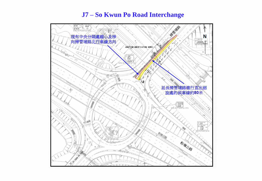
J7 – So Kwun Po Road Interchange

3
3
J8 – Po Shek Wu Road Interchange

Appendix B
Proposed Junction Improvement Schemes

Drawing No. B1
J2 – Po Shek Wu Road / Po Wan Road (to be Completed by 2023)
Modification of the road marking
from “Straight Ahead” to “Shared
Left Turn and Straight Ahead”
Removal of existing planter to
provide an additional receiving
lane of Po Wan Road WB
Legend:
KNP Scheme
HKHA Scheme

Drawing No. B3
J3 – Po Shek Wu Road / Choi Yuen Road (to be Completed by 2023)
Legend:
KNP Scheme

Drawing No. B4
J5 – Jockey Club Road / Lung Sum Avenue (to be Completed by 2023)
Legend:
KNP Scheme
Queen’s Hill Scheme

Drawing No. B5
J6 – Jockey Club Road / So Kwun Po Road (to be Completed by 2023)
Legend:
NDA Scheme
HKHA Scheme
Removal of existing planter and
slope work to provide an
additional “Straight Ahead” lane
of So Kwun Po Road NB
Removal of existing planter to
provide an additional receiving
lane of Ma Sik Road NBProvision of deck structure to
maintain footpath along Ma Sik
Road NB.

Drawing No. B6
J8 – Po Shek Wu Road Interchange (to be Completed by 2023)
Legend:
KNP Scheme
Queen’s Hill Scheme