proposed ndumo gezisa 132kv single circuit … - ba for ndumo-gezisa 132kv... · working area...
TRANSCRIPT

Zitholele Consulting Reg. No. 2000/000392/07 PO Box 6002 Halfway House 1685 South Africa Thandanani Park, Matuka Close Halfway Gardens, Midrand Tel + (27) 11 207 2060 Fax + (27) 86 674 6121 E-mail : [email protected]
Directors : S Pillay (Managing Director); N Rajasakran (Director); Mr Andre Van Nieker (Director)
AMENDED FINAL BASIC ASSESSMENT REPORT
PROPOSED NDUMO GEZISA 132kV SINGLE
CIRCUIT POWER LINE OR A 132/22kV
MULTI-CIRCUIT POWER LINE
Report No : 12775-46-Rep-001-BAR-Rev1 - Basic Assessment Report
Submitted to:
Department of Environmental Affairs Environment House
Corner of Steve Biko Road and Soutpansberg Road
Pretoria, 0001 South Africa
DISTRIBUTION:
2 Copies - Department of Environmental Affairs 1 Copy - Zitholele Consulting (Pty) Ltd – Library
15 September 2014 12775

FINAL BASIC ASSESSMENT REPORT
2
TABLE OF CONTENTS
SECTION A: ACTIVITY INFORMATION .................................................................... 5
1 PROJECT DESCRIPTION ............................................................................ 5 2 FEASIBLE AND REASONABLE ALTERNATIVES ..................................... 10 3 PHYSICAL SIZE OF THE ACTIVITY .......................................................... 16 4 SITE ACCESS ............................................................................................. 16 5 LOCALITY MAP ........................................................................................... 17
6 LAYOUT/ROUTE PLAN .............................................................................. 18 7 SENSITIVITY MAP ...................................................................................... 18 8 SITE PHOTOGRAPHS ................................................................................ 18 9 FACILITY ILLUSTRATION .......................................................................... 18 10 ACTIVITY MOTIVATION ............................................................................. 19
11 APPLICABLE LEGISLATION, POLICIES AND/OR GUIDELINES ............. 27 12 WASTE, EFFLUENT, EMISSION AND NOISE MANAGEMENT ............... 31 13 WATER USE ............................................................................................... 33
14 ENERGY EFFICIENCY ............................................................................... 33 SECTION B: SITE/AREA/PROPERTY DESCRIPTION .......................................... 34 1. GRADIENT OF THE SITE ........................................................................... 34 2. LOCATION IN LANDSCAPE ....................................................................... 35
3. GROUNDWATER, SOIL AND GEOLOGICAL STABILITY OF THE SITE ............................................................................................................. 35
4. GROUNDCOVER ........................................................................................ 35 5. SURFACE WATER ..................................................................................... 37 6. LAND USE CHARACTER OF SURROUNDING AREA ............................. 41
7. CULTURAL/HISTORICAL FEATURES ...................................................... 42
8. SOCIO-ECONOMIC CHARACTER ............................................................ 42 9. BIODIVERSITY ............................................................................................ 43 SECTION C: PUBLIC PARTICIPATION .................................................................. 54
1. ADVERTISEMENT AND NOTICE............................................................... 54 2. DETERMINATION OF APPROPRIATE MEASURES ................................ 54
3. ISSUES RAISED BY INTERESTED AND AFFECTED PARTIES ............. 56 4. COMMENTS AND RESPONSE REPORT ................................................. 61
5. AUTHORITY PARTICIPATION ................................................................... 62 6. CONSULTATION WITH OTHER STAKEHOLDERS .................................. 65 SECTION D: IMPACT ASSESSMENT ..................................................................... 66
1. IMPACTS THAT MAY RESULT FROM THE PLANNING AND DESIGN, CONSTRUCTION, OPERATIONAL, DECOMMISSIONING AND CLOSURE PHASES AS WELL AS PROPOSED MANAGEMENT OF IDENTIFIED IMPACTS AND PROPOSED MITIGATION MEASURES .......................................................................... 66
ENVIRONMENTAL ASPECT AND IMPACT REGISTER ........................................ 98 2. ENVIRONMENTAL IMPACT STATEMENT .............................................. 110 SECTION E. RECOMMENDATION OF PRACTITIONER ................................ 115 SECTION F. APPENDICES .............................................................................. 117

FINAL BASIC ASSESSMENT REPORT
3
LIST OF APPENDICES
Appendix A: Maps Appendix B: Site Photographs Appendix C: Facility Illustration Appendix D: Specialist Reports (Including Terms of Reference) Error! Not a valid result for table. Appendix F: Impact Assessment Appendix G: Environmental Management Programme (EMPr) Appendix H: Details of EAP and Expertise Appendix I: Specialist Declaration of Interest Appendix J: Additional Information

FINAL BASIC ASSESSMENT REPORT
4
(For official use only)
File Reference Number:
Application Number:
Date Received:
Basic assessment report in terms of the Environmental Impact Assessment Regulations, 2010, promulgated in
terms of the National Environmental Management Act, 1998 (Act No. 107 of 1998), as amended.
Kindly note that:
1. This basic assessment report is a standard report that may be required by a competent authority in terms
of the EIA Regulations, 2010 and is meant to streamline applications. Please make sure that it is the report
used by the particular competent authority for the activity that is being applied for.
2. This report format is current as of 1 September 2012. It is the responsibility of the applicant to ascertain
whether subsequent versions of the form have been published or produced by the competent authority
3. The report must be typed within the spaces provided in the form. The size of the spaces provided is not
necessarily indicative of the amount of information to be provided. The report is in the form of a table that
can extend itself as each space is filled with typing.
4. Where applicable tick the boxes that are applicable in the report.
5. An incomplete report may be returned to the applicant for revision.
6. The use of “not applicable” in the report must be done with circumspection because if it is used in respect of
material information that is required by the competent authority for assessing the application, it may result in
the rejection of the application as provided for in the regulations.
7. This report must be handed in at offices of the relevant competent authority as determined by each authority.
8. No faxed or e-mailed reports will be accepted.
9. The signature of the EAP on the report must be an original signature.
10. The report must be compiled by an independent environmental assessment practitioner.
11. Unless protected by law, all information in the report will become public information on receipt by the
competent authority. Any interested and affected party should be provided with the information contained in
this report on request, during any stage of the application process.
12. A competent authority may require that for specified types of activities in defined situations only parts of this
report need to be completed.
13. Should a specialist report or report on a specialised process be submitted at any stage for any part of this
application, the terms of reference for such report must also be submitted.
14. Two (2) colour hard copies and one (1) electronic copy of the report must be submitted to the competent
authority.
15. Shape files (.shp) for maps must be included on the electronic copy of the report submitted to the competent
authority.

FINAL BASIC ASSESSMENT REPORT
5
SECTION A: ACTIVITY INFORMATION
Has a specialist been consulted to assist with the completion of this section? YES NO
If YES, please complete the form entitled “Details of specialist and declaration of interest” for the specialist
appointed and attach in Appendix I.
1 PROJECT DESCRIPTION
a) Describe the project associated with the listed activities applied for a) Background and Context
Eskom Distribution’s – KwaZulu-Natal Operation Unit is in the process of upgrading the electricity infrastructure in the Makhathini Flats area of northern KwaZulu-Natal. The existing Makhathini 22kV distribution network is highly constrained in terms of capacity and is unable to supply current and additional electrification requirements in the Candover, Mbazwana and Manguzi areas. Eskom is therefore committed to establishing a new 132kV network of power lines and substations on the Makhathini Flats to strengthen the existing electrification network and cater for future electrification loads. The following 132kV network expansion is presently in progress:
Nondabuya-Ndumo 132kV power line and Ndumo 132/22kV substation – Environmental Authorisation was obtained on 29 August 2011 and is currently under construction;
Candover-Mbazwana-Gezisa 132kV power line and proposed 132/22kV substations at Mbazwana and Gezisa (Manguzi) –Basic Assessment is complete and awaiting Environmental Authorisation from the Department of Environmental Affairs; and
Ndumo Gezisa 132/22kV multi-circuit or a single 132kV single-circuit power line – is presently undergoing a Basic Assessment (the subject of this application).
The construction of a 132/22kV multi-circuit power line or 132kV single circuit power line between the Ndumo and Gezisa Substations is part of the larger Makhathini electrification project to form a closed circuit (ring) of power lines on the Makhathini Flats. Construction and operation of the above proposed 22/132kV multi-circuit power line or 132kV single circuit power line is subject to a Basic Assessment (BA) in terms of Section 14 of the National Environmental Management Act, No 107 of 1998 (NEMA), as amended. In fulfilment of this requirements, Eskom has appointed Zitholele Consulting (Pty) Ltd as the independent Environmental Assessment Practitioner (EAP) to undertake the BA process.
b) Project Description
Study Area The study area where the proposed activity is to take place is located in northern KwaZulu-Natal to the south of the Mozambique border and between the towns of Ndumo and Emanguzi. The study area falls within the Jozini and Umhlabuyalingana Local Municipality area which forms part of the Umkhanyakude District Municipality. The study area is currently dominated by the Tembe Elephant Reserve, ribbon development along the main arterial road (Provincial Road P522) which traverses the study area between the Pongola River in the west and Emanguzi Town in the east. The proposed power line will run from the Ndumo Substation presently under construction in the west to the proposed Gezisa Substation in the east. 132/22kV Multi-circuit Power line The proposed 132kV portion of the 132kV/22kV multi-circuit power line will consist of three conductors in a delta configuration protected by a thinner shield / earth wire above. The 22kV portion of the multi-circuit power line occurs on the same set of pylons but lower down and is itself comprised of 3 conductors also in a delta configuration. The pylons will be stand sectional steel pole structures. Opting for a multi-circuit 132kV/22kV power line as opposed to a single circuit 132kV line and another parallel 22kV power line will reduce the required working area during the Construction Phase, as well as the footprint of the power line within the servitude.
Servitude Clearance Requirements High voltage 132kV power lines require a large clearance area for safety precautions. The Occupational Health and Safety Act, 1993 (Act No. 85 of 1993) provides for statutory clearances.

FINAL BASIC ASSESSMENT REPORT
6
Table 1: Electrical Clearance Specifications for 132/22kV Multi-Circuit Power Line (Eskom)
Clearances Minimum Clearance Distance (m)
Ground clearance 6.3
Building structures not part of power line 3.8
Above roads and in townships, proclaimed roads 7.5
Telecommunication lines 2.0
Table 2: Minimum Clearance Chart for Power lines from Roads (132kV – KZN Region)
National Roads: any part of structure greater than 60m , from road reserve boundary
KZN Main Roads: (any part of structure) greater than 35m from centre line of road or 15m from road fence
KZN District roads: (any part of structure) 20m from central line of the road
Access Access is required during both the construction and operation/maintenance phases of the power line’ life cycle. Where possible, existing access roads and tracks will be used to gain access to construction sites and the servitude. Access roads will enable the transportation of construction material as well as construction teams to the site and facilitate maintenance activities once the power line has been constructed.
Foundations The type of terrain encountered, underlying geotechnical conditions as well as the pylon type required determines the choice of foundation. The actual size and type of foundation to be installed will depend on the soil bearing capacity (actual sub-soil conditions). Foundations will be mechanically excavated where access to the site is readily available. All foundations are back-filled, stabilised through compaction, and capped with concrete at ground level.
Towers (Pylons) The pylons (towers) can be located approximately 250m to 400m apart on level ground (this applies to lattice towers only), pole structures will be closer i.e. around 200m to 250m, but the span length can be increased up to 1300m when crossing steep-sided valleys and depending on the terrain not applicable on this project, other than the Pongola River crossing. A combination of the following single circuit pylons are proposed to be used:
255a Lattice Suspension Tower (Delta Configuration);
255b Lattice Angle Strain Towers (Delta Configuration);
255c Lattice Angle Strain Towers (Delta Configuration);
255d Lattice Angle Strain Towers (Delta Configuration);
273a Guyed Lattice Suspension Towers (Delta Configuration);
273b Guyed Lattice Suspension Towers (Delta Configuration);
273c Guyed Lattice Suspension Towers (Delta Configuration);
273e Guyed Lattice Angle Strain Tower (Delta Configuration);
248a Lattice Suspension Tower (Horizontal Configuration);
248b Lattice Angle Strain Towers (Horizontal Configuration); and
248c Lattice Angle Strain Towers (Horizontal Configuration).
In the unusual event of a multi-circuit line being required by Eskom, the following pylons are proposed to be used:
245a Lattice Suspension Tower (Vertical Configuration);
245b Lattice Angle Strain Towers (Vertical Configuration);
245c Lattice Angle Strain Towers (Vertical Configuration);
245d Lattice Angle Strain Towers (Vertical Configuration); and
245e Lattice Angle Strain Towers (Vertical Configuration). The actual pylon footprints for the self-supporting lattice towers range from between 5m x 5m square and 11m x 11m square depending on the structure that is used. The actual footprints for the guyed towers range from between 11m x 11m square and 30m x 30m square depending on

FINAL BASIC ASSESSMENT REPORT
7
the height of the structure required. The pylon also differs in structure to accommodate increased strain when a bend is made in the power line. The pylons will be approximately 18 – 25 m high (which varies depending on terrain) and require a 36m wide servitude i.e. 18m either side of the centre line of the servitude. Drawings of the proposed pylons to be used are presented in Appendix C of this BAR. Approval is sought for a corridor 1 km wide for the power line to allow for deviations within the approved corridor once a final route has been negotiated with landowners.
c) Power line Design, Construction and Operation Activities Design Phase Activities The following activities will be carried out during the Design Phase;
Environmental survey of study area;
Selection of alternative power line corridors;
Determination of technically feasible alternatives;
EIA input into route selection and obtaining government authorisation;
Negotiation of final line route and servitude with affected landowners;
Route survey and Corridor walk-down: To ensure that all site specific sensitivities are avoided. During this process the exact co-ordinates of the proposed towers will be established; and
Final design of line and placement of towers.
Construction Phase Activities The following activities will be carried out during the Construction Phase:
Construction Camps: Construction camps will be sited in areas where least disturbance to potentially sensitive environments will be caused;
Batching Plants: If Readymix concrete is not available, small mobile batching plants will have to be established in the area close to the power line;
Access: Access tracks will be clearly demarcated. Vegatation within the demarcated access tracks will be removed, to allow large construction vehicles to gain access the proposed servitude.
Vegetation clearance: A 36m wide servitude is required for the proposed 132kV power line. Trees and shrubs will be cleared where required along the entire length of the servitude for access, erection of the pylons and stringing of the conductor (the vegetation will also be maintained by Eskom in the operational phase of the project);
Surveying, pegging and soil nominations: During construction the route will be surveyed, pegged and the soil nominations undertaken for each of the potential pylon foundations.
Pylon footings: Foundations will be laid for the footings of the pylons. The first step is the excavation of the pylon foundations, the reinforcing thereof and finally the concreting of the foundations. The equipment required to excavate the foundations can be manual labour, a Tipper-Loader-Back Hoe or in the case of hard rock – a drilling rig will be required. The concrete will have to be transported by concrete cement mixer trucks to the required locations. The option of using screw anchors will be considered for the steel lattice towers, depending on cost comparisons with conventional type concrete foundations. The 253 & 259 type steel monopole structures are planted directly into the ground and have a concrete collar cast around the base thereof, such structures cannot accommodate the use of screw anchor type foundations;
Tower Structures: The towers will be erected in stages. After the foundations and footings have been installed the construction team will transport the various steel parts of the towers to the site and start erection of the pylons. This process requires manual labour to layout and assemble the towers on the ground. Mobile cranes are used to lift and erect the towers onto their foundations;
Stringing: Once the towers have been erected, conductors and the earth or shield wire will be strung between the towers. Once stringing and tensioning is complete, the line is dressed and tested prior to being commissioned; and
Rehabilitation: The following activities will be carried out during the rehabilitation and management of the working area along the power line route alignment: o Remove all construction plant, equipment, storage containers, temporary fencing from
the working area and site camps (where applicable);
o As far as possible all disturbed areas should be shaped to blend in with the surrounding

FINAL BASIC ASSESSMENT REPORT
8
landscape;
o Ensure that no excavated material or stockpiles remain within the working area and that
any remaining is used for shaping the disturbed areas to blend in with the surrounding
landscape;
o Topsoil should be placed in the same area from where it was removed; and
o Following the placement of the topsoil, all areas within the working area should be
ripped and / or scarify to facilitate mixing of the upper most soil layers;
o Alien vegetation monitoring and management should be carried out on an ongoing
basis during the operation of the powerlines.
Both the Design Phase and Construction Phase of the proposed project will take approximately 60 months to complete. The Design Phase and Construction Phase may only commence if Environmental Authorisation to proceed with the activities are granted by the Competent Authority.
Operational Phase Activities During the Operational and Maintenance Phase of the proposed project, Eskom will require access to the servitude to carry out maintenance activities. Maintenance activities may include repairs and replacement of various hardware on the towers and the conductor as well as repairs to the foundations. .
Decommissioning Phase Activities The physical removal of the power line infrastructure would entail the reversal of the construction process which would necessitate the following action to be taken:
A rehabilitation programme would need to be agreed upon with the landowners (if applicable) before being implemented.
Materials generated by the decommissioning process will be disposed of according to the Waste Hierarchy i.e. wherever feasible, materials will be reused, then recycled and lastly disposed of. Materials will be disposed of in a suitable manner, in a suitably licensed facility
All of the aforementioned Decommissioning Phase activities would be subject to a separate Environmental Authorisation Process.

FINAL BASIC ASSESSMENT REPORT
9
Overview of Environmental Features of the Study Area
The natural topography of the study area is relatively flat except for the portion west of the
Pongola River which has a slightly higher elevation than that east of the Pongola River. The
western portion of the study are is characterised by an undulating landscape defined by the
Pongola River and various drainage channels. Conversely, the eastern portion is generally more
flat and characterised by large wetland-type habitats on the former coastal plain.
The majority of the Maputaland region falls under rural community land-use. As such, large
sections of the study area and surrounding landscape are characterised by rural villages and
scattered households, with associated activities, such as subsistence agriculture, livestock
farming and natural resource harvesting. Areas displaying high levels of anthropogenic
development or impacts are typically aligned with the main Jozini – eMangusi / Kosi Bay P522
arterial road and the various rural feeder roads, as well as along prominent water courses such as
the Pongola River. Beyond these high-impact zones, the land is generally in a natural to semi-
natural condition and used primarily for the grazing of cattle and goats. Additional areas where
high levels of anthropogenic development or impacts are evident include the areas surrounding
the towns of Skhemelele and the proposed Phelindaba layout.
Two regionally important conservation areas, namely Tembe Elephant Park and Ndumu Nature Reserve, are located in this region of Maputaland. The former is situated in the centre of the study area, while the latter is situated to the north-west. Moreover, the smaller, less well known Sileza Nature Reserve is located in the south-eastern portion. Based on species composition, physiognomy, moisture regime, slope and disturbance characteristics, the following five broad vegetation communities/ units were recognised in the study area during the 2013 field survey (Golder Associates Africa, 2014:11) (refer to Appendix D1):
Hyphaene moist grasslands;
Strychnos – Terminalia sand bushveld;
Mixed bushveld;
Sand forest; and
Riparian vegetation community.4
It must be noted that a natural variation within the vegetation communities has resulted from various natural influences, as well as current and historic anthropogenic disturbance.
b) Provide a detailed description of the listed activities associated with the project as applied for
Listed activity as described in GN R.544, 545 and 546
Description of project activity
GN R.544, 18 June 2010 Item 10(i) The construction of facilities or infrastructure for the transmission and distribution of electricity (i) Outside urban areas or industrial
complexes with a capacity of more than
33 but less than 275 kV.
Construction of a multi-circuit high voltage
electricity transmission line between the
existing Ndumo Substation and the proposed
Gezisa substations or the construction of a
single 132kV high voltage power line.
GN R.544, 18 June 2010 Item 11(xi) The construction of infrastructure or structures within a watercourse or within 32m of a watercourse.
Some of the power line structures may have to be placed within 32 m of the banks of the Pongola River (estimated 2 structures), within a floodplain, or within the Muzi wetlands.
GN R.544, 18 June 2010 Item 26 Any process or activity identified in terms of Section 53(1) of NEM: Biodiversity Act, 2004
The Ndumo to Gezisa area is known for it’s environmental sensitivity due to the presence of Sand Forest patches and the location of the Ndumo Nature Reserve and the Tembe Elephant Park Nature Reserve.

FINAL BASIC ASSESSMENT REPORT
10
Listed activity as described in GN R.544, 545 and 546
Description of project activity
GN R546 18 June 2010 Item 13 (a) (c) ii The clearance of an area of 1 hectare or more of vegetation where 75 % or more of the vegetative cover constitutes indigenous vegetation.
Clearing of indigenous vegetation along the servitude will occur and will exceed 1 ha in totality.
GN R546, 18 June 2010 12(a) The clearance of an area of 300 square metres or more of vegetation where 75% or more of the vegetative cover constitutes indigenous vegetation. (a) Within any critically endangered or endangered ecosystem listed in terms of section 52 of the NEMBA or prior to the publication of such a list, within an area that has been identified as critically endangered in the National Spatial Biodiversity Assessment 2004;
Sections of the power line will require the clearing of indigenous bush and this may include (depending on final power line routing within the preferred corridor) the clearing of Sand Forest.
GN R546 18 June 2010 16(iv) (a) ii. (hh) The construction of: (iv) infrastructure covering 10 square metres or more where such construction occurs within a watercourse or within 32 metres of a watercourse, measured from the edge of a watercourse, excluding where such construction will occur behind the development setback line.
The power line structures will cover an area of 10m
2 or more and some of them may have to be
placed within 32m of a watercourse/wetland where unavoidable. This will occur within 5 km of the Tembe Elephant Nature Reserve.
2 FEASIBLE AND REASONABLE ALTERNATIVES “alternatives”, in relation to a proposed activity, means different means of meeting the general purpose and requirements of the activity, which may include alternatives to— (a) the property on which or location where it is proposed to undertake the activity; (b) the type of activity to be undertaken; (c) the design or layout of the activity; (d) the technology to be used in the activity; (e) the operational aspects of the activity; and (f) the option of not implementing the activity.
Describe alternatives that are considered in this application as required by Regulation 22(2)(h) of GN R.543.
Alternatives should include a consideration of all possible means by which the purpose and need of the
proposed activity (NOT PROJECT) could be accomplished in the specific instance taking account of the
interest of the applicant in the activity. The no-go alternative must in all cases be included in the assessment
phase as the baseline against which the impacts of the other alternatives are assessed. The determination of
whether site or activity (including different processes, etc.) or both is appropriate needs to be informed by the
specific circumstances of the activity and its environment. After receipt of this report the, competent authority
may also request the applicant to assess additional alternatives that could possibly accomplish the purpose
and need of the proposed activity if it is clear that realistic alternatives have not been considered to a
reasonable extent.

FINAL BASIC ASSESSMENT REPORT
11
The identification of alternatives should be in line with the Integrated Environmental Assessment Guideline
Series 11, published by the DEA in 2004. Should the alternatives include different locations and lay-outs, the
co-ordinates of the different alternatives must be provided. The co-ordinates should be in degrees, minutes
and seconds. The projection that must be used in all cases is the WGS84 spheroid in a national or local
projection.
Please Note Based on the outcome of the process identifying reasonable corridor alternatives the following Alternatives are assessed and presented in this BAR and are identified as follows (refer to Appendix A2):
Alternative 1 - Corridor 3P (Preferred);
Alternative 2 – Corridor 3A;
Alternative 3 – Corridor 3B; and
Alternative 4 – Corridor 3C.
a) Corridor alternatives In the case of linear activities:
Alternative: Latitude (S): Longitude (E): Alternative 1 – Corridor 3P (preferred)
Starting point of the activity 27° 00' 16.23" S 32° 15' 12.69" E
Middle/Additional point of the activity 27° 04' 31.09" S 32° 28' 09.46" E
Identification of Reasonable Corridor Alternatives The following process was implemented in the identification of feasible and reasonable alternatives for the construction and operation of a multi-circuit 132/22kV power line connecting the Ndumo and Gezisa substations. A desktop assessment of the study area was undertaken using GIS biodiversity data provided by Ezemvelo KZN Wildlife and landuse data provided by KZN Meteorological Data. During this desk top assessment, technical input was provided by Eskom to further assist identifying reasonable and feasible alternatives. At this level of assessment, the following potential corridors were identified:
Corridor 1 – Northern Corridor;
Corridor 2 – Central Corridor;
Corridors 3A to 3C – South Central Corridors; and
Corridor 3D – Southern Corridor. The six corridor alternatives were then assessed by specialists in the following disciplines:
Avifauna – Endangered Wildlife Trust;
Heritage – PGS Heritage;
Terrestrial Ecology – Golder & Associates;
Surface Water and Wetlands – Jones & Wagener;
Visual – Jones & Wagener; and
Land Use and Capability – Zitholele Consulting. Subsequent to the interpretation of the specialists and obtaining feedback from Eskom Technical Designers two additional short sections of corridor (Corridor 3E and 3F) were included for assessment as part of the South Central Corridors. The Avifauna and Terrestrial Ecology specialists concluded that Corridors 1 – Northern Corridor, Corridor 2 – Central Corridor and Corridor 3D – Southern Corridor and Corridor 3F were all fatally flawed in terms of environmental issues and were declared “NO GO” options. Subsequent to these studies, an additional corridor was identified and included an amalgamation of the South Central corridors into a preferred route i.e. Corridor 3P (Preferred). The map in Appendix A1 shows the location of all the alternative corridors considered in this process.

FINAL BASIC ASSESSMENT REPORT
12
End point of the activity 27° 01' 18.68" S 32° 38' 56.08" E
Alternative 2 – Corridor 3A
Starting point of the activity 27° 00' 16.23" S 32° 15' 12.69" E
Middle/Additional point of the activity 27° 02' 14.41" S 32° 17' 14.41" E
End point of the activity 27° 01' 18.68" S 32° 38' 56.08" E
Alternative 3 – Corridor 3B
Starting point of the activity 27° 00' 16.23" S 32° 15' 12.69" E
Middle/Additional point of the activity 27° 05' 37.61" S 32° 29' 53.99" E
End point of the activity 27° 01' 18.68" S 32° 38' 56.08" E
Alternative 4 – Corridor 3C
Starting point of the activity 27° 00' 16.23" S 32° 15' 12.69" E
Middle/Additional point of the activity 27° 04' 23.36" S 31° 32' 56.82" E
End point of the activity 27° 01' 18.68" S 32° 38' 56.08" E For route alternatives that are longer than 500m, please provide an addendum with co-ordinates taken every 250 meters along the route for each alternative alignment. In the case of an area being under application, please provide the co-ordinates of the corners of the site as indicated on the lay-out map provided in Appendix A.
b) Lay-out alternatives “Layout alternatives” in the context of this application refers to the spatial configuration or alignment of the proposed power lines corridors. All four potential route alignments are shown on the layout map in Appendix A2. A map showing the preferred route alignment is included as Appendix A3.
Alternative 1 (preferred): Corridor 3P
Description
This corridor traverses from the Ndumo Substation in a south easterly direction towards the proposed Pongola River crossing at Makhane’s Drift. This corridor will cross the Pongola River to the south of the existing high level pedestrian bridge over the Pongola River. Once across the Pongola River, the corridor parallels to the south west of the gravel District Road D1861 until its junction with the P522. Thereafter the corridor parallels the P522 in an easterly direction and to the south of the P522. 2.4 km from to the west of the junction of the P522 with the R22 the corridor veers away and to the south of the P522 up to a distance of 0.9 km in order to traverse around the Phelandaba township area. Once beyond the township, the proposed corridor traverses back towards the P522 and crosses over the P522 approximately 2.3 km to the east of the junction with the R22 where after it runs parallel to the P522 to the north for approximately a further 5.5km where after it runs in a north easterly direction to the Gezisa substation.
Alternative 2: Corridor 3A
This corridor traverses from the Ndumo substation in a southerly direction for approximately 3.4 km where it intersects the P522 and runs parallel to the P522 crossing over the Pongola River and traversing to the north of Lulwane settlement area for 6.5 km until returning to parallel to the immediate south of the P522 all the way until it turns north to the Gezisa substation. Portions of this corridor correspond with that of the preferred corridor described above.
Alternative 3: Corridor 3B
Description
This corridor traverses from the Ndumo substation in a due easterly direction for approximately 3.95 km where after it turns in a south easterly direction to cross over the Pongola River at Makhane’s Drift. After crossing the Pongola River this corridor continues in a south easterly direction until it intersects and crosses the P522. Thereafter it parallels the P522 in an easterly direction approximately 1 km south of the road up until it crosses back over the P522 to travel direct north to the Gezisa substation

FINAL BASIC ASSESSMENT REPORT
13
Alternative 4: Corridor 3C
Description
This corridor follows the exact same routing as Corridor 3B until 3.2 km west of the intersection with the R22 where it veers off to the north east to cross over the P522 and continue in a north easterly direction north of Phelandaba township area to the Gezisa substation.
c) Technology alternatives
Alternative 1(Preferred Alternative): Multi-circuit Overhead Power line A final decision has not been reached with regards to whether a 132/22kV multi-circuit power line or a 132kV single circuit power line will be constructed. The construction of a multi-circuit power line would indicate that the multi-circuit tower will carry the conductors of two different voltages, therefore a multi-cicruit power line will be selected in the event where both the 132kV and 22kV power lines will be constructed. Where sensitive environmental features are identified, and there is sufficient justification, Eskom will consider the use of a multi-circuit (placing a 132kV line and a 22kV power line on the same tower structure) to reduce impacts. The use of multi-circuiting has a number of technical disadvantages:
Faults or problems on one power line may mean that the other power line is also disabled during maintenance, and this will affect the quality of supply to an area;
Larger and taller towers as well as more towers are required for multi-circuit power lines; and
Carrying out maintainance on one power line while the other remains switched on poses a safety hazard.
However, in this instance, the combining the 22kV and 132kV power lines onto a single multi-circuit structure is advantageous as it will combine overhead impacts into a central corridor and result in reduced working area required within the power line servitude. Furthermoore combining the 22kV and 132kV power lines onto a single multi-circuit structure will also mean that two separate servitudes can be combined into a single servitude. In the event where a second 22kV power line is required, placing the power line on the “existing”
1 132kV/22kV multi-
circuit structure, may reduce the impacts associated with placing the additional 22kV power line on the same structure.
Alternative 2 (preferred alternative) – Single Circuit 132kV Overhead Power line The use of single circuit overhead power lines to distribute electricity is usually considered the most appropriate technology and has been designed over may years for the existing environmental conditions and terrain as specified by Eskom Specifications and best international practice. Based on all current technologies available, single circuit overhead power lines are considered the most environmentally practicable technology available for the distribution of power. This option is considered appropriate for the following reasons:
More cost effective installation costs;
Less environmental damage during installation; and
More effective and cheaper maintenance costs over the lifetime of the power line.
Taking into account that a 22kV power line in addition to the 132kV power line may be constructed, the sensitive environment in the study area and the lack of space for numerous servitudes in the developed zones, may necceistate opting for a multi-ciruit power line rather than opting for a single ciruit power line.
Alternative 3 – Underground Cabling Underground cabling of high voltage power lines over long distances is not considered a feasible or environmentally practicable alternative for the following reasons:
Underground cabling will incur significantly higher installation and maintenance costs;
It is more difficult and takes longer to isolate and repair faults on underground cables;
There is increased potential for faulting at the transition point from underground cable to overhead power line;
1 The “existing” multi-circuit structure refers to the completed 132kV/22kV multi-cicruit overhead power line, following the completion of the Construction Phase and provided that Environmental Authorisation is granted for the proposed project.

FINAL BASIC ASSESSMENT REPORT
14
Underground cables require a larger area to be cleared and disturbed during construction or maintenance and hence have a bigger environmental disturbance footprint; and
Underground cabling requires the disturbance of a greater area when it comes to agriculture and other compatible land uses as the entire servitude becomes available for use as opposed to just the area around the towers.
Note: A number of factors are taken into consideration when determining whether to opt for
underground cabling or overhead power lines. The table below provides a summary of the key
considerations which are taken into account by Eskom when deciding on whether to use
overhead power lines or underground cabling.
Comparative Analysis
Aspect Underground Cabling Overhead Power Line
Disturbed Area
A working are of approximately 15m wide is required to allow adequate space for:
Excavating material from the trench (approximately 1 – 2m deep);
Stockpiling of excavated soil; and
Accommodating a service road and movement of vehicles during the Construction Phase.
The surface area covered by the tower base will require a working area of approximately insert surface area (40mx40m);
An area of 12m3 will be excavated
to place and secure the self-supporting steel structures.
Vegetation Clearing
Vegetation along the entire length of the cable will be removed.
Vegetation will only be cleared at the specific tower locations, estimated to be placed every 350m in relatively flat areas; and
In areas where the access to the servitude can be easily gained vegetation within the demarcated access tracks will be cleared. Where the power line extends across steep and inaccessible terrain alternative means of constructing access tracks will be used.
Rehabilitation
Active rehabilitation (e.g. management of alien and invasive species) of the disturbed area will be required throughout the Operational Phase.
Owing to the limited disturbance of and vegetation clearing required for placing the towers, the area to be rehabilitated may be reduced.
Technical Implications
The use of copper and insulation increases the cost associated with underground cabling;
Subject to the site specific soil conditions, the costs associated with the trenching required for placing underground cabling is high;
Cables require additional infrastructure in the form of a “Sealing end substation” that is used as an interface between cable and overhead lines; and
Cables have a longer repair time due to fault finding and trenching to repair the fault.
Shorter repair time for overhead power lines as opposed to the repair time required for under cables;
No additional infrastructure required; and
Excavations will only be required at the locations of the towers along the route alignment, thereby reducing the costs associated with excavating foundations.
Spoil Large volumes of spoil will be generated by trenching.
Excavated topsoil will be used for rehabilitation of the disturbed area; and
Minimal spoil is generated by the excavations done for placing the towers.

FINAL BASIC ASSESSMENT REPORT
15
d) Other alternatives – Tower Design Alternatives
Alternative 1 – Steel Lattice Towers The steel lattice towers provide the following advantages over the other tower types available:
Enables multipath earthing which enhances the overall electrical performance of the power line;
Is visually less obtrusive than the mono-pole options;
Is more practicable that other options i.e. more cost effective and more practical to construct and maintain;
Is safer to work on than the monopole and wood pole structures; and
Is more durable than the woodpole structures.
Alternative 2 – Steel Monopoles The steel monopole may be considered less suitable than the steel lattice towers for the following reasons:
Is visually more intrusive than the lattice towers;
Is more expensive than the lattice towers;
Requires more steel than the lattice towers;
Is more difficult to erect; and
Is not as safe to work on as the lattice towers.
Although the steel monopoles will cover a smaller area within the servitude as opposed to the surface area of steel lattice, technical constraints such as the tendency of corrosion on the inside of the monopole and the implications thereof, renders the use of steel monopoles less favourable. However in sensitive environments, more favourable as it As steel monopoles will result in a smaller working area within the servitude as well as the smaller surface area of the tower bases than that of the steel lattice towers, the use of steel monopoles are favoured for use within sensitive environments.
e) No-go alternative The ‘No Go’ alternative in the context of this project implies that the power line would not be
constructed. If the power line does not go ahead, the negative environmental impacts which have
been identified if it does go ahead would not occur. However, if the power line is not constructed
and commissioned, the region would be negatively affected by an inadequate and unreliable supply
of electricity (a basic service) which would inhibit future development in Northern Zululand.
In the event where the proposed project is not implemented, the unrealiable and inqdequet supply of
electricity, would jeopardise the success of the regions Integrated Development Plans and Spatial
Development Frameworks, all of which identify the lack of electrical services as inhibitors to future
development and an improved quality of life. Therefore, the need for stable and reliable power
supply to meet current and future demand will likely outweigh the potential negative impacts to the
surrounding environment. It is thereby concluded that the “No-go‟ option is not in the best interests
of future sustainable development in this region.
FINAL BASIC ASSESSMENT REPORT
16
Paragraphs 3 – 13 below should be completed for each alternative.
3 PHYSICAL SIZE OF THE ACTIVITY
a) Indicate the physical size of the preferred activity/technology as well as alternative
activities/technologies (footprints):
Alternative: Length of the activity:
Alternative 1 (preferred) – Corridor 3P ± 44 000 m
Alternative 2 – Corridor 3A ± 47 000 m
Alternative 3 – Corridor 3B ± 47 500 m
Alternative 4 – Corridor 3C ± 46 000 m
b) Indicate size of the alternative sites or servitudes (within which the above footprints will occur):
Alternative: Size of the site/servitude:
Alternative 1 (preferred) – Corridor 3P (36 m wide) 1 584 000 m2
Alternative 2 – Corridor 3A (36 m wide) 1 692 000 m2
Alternative 3 – Corridor 3B (36 m wide) 1 710 000 m2
Alternative 4 – Corridor 3C (36 m wide)1 656 000 m2
4 SITE ACCESS
Alternative 1 (preferred) –Corridor 3P
Does ready access to the site exist? YES NO
If NO, what is the distance over which a new access road will be built
Alternative 2 – Corridor 3A
Does ready access to the site exist? YES NO
If NO, what is the distance over which a new access road will be built 30 000 m
Alternative 3 –Corridor 3B
Does ready access to the site exist? YES NO
If NO, what is the distance over which a new access road will be built 40 000 m
Alternative 4 –Corridor 3C
Does ready access to the site exist? YES NO
If NO, what is the distance over which a new access road will be built 40 000 m
Describe the type of access road planned:
ACCESS ROADS
Alternative 1 (Preferred) –
Corridor 3P
The preferred corridor largely parallels existing roads and passes
through areas where numerous access tracks are already existing
and these will be used to gain access to the servitude. It is therefore
foreseen that construction of new access routes will not be required.
It may be necessary to widen existing access tracks to permit the
passage of construction vehicles.

FINAL BASIC ASSESSMENT REPORT
17
ACCESS ROADS
Alternative 2 – Corridor 3A
Due to the close proximity of the P522 main road to the corridor as
well as the prescence of numerous existing tracks that will permit
access ot the servitude by the construction vehicles, new access
tracks for Corridor 3A will not be required.
Alternatives 3 – Corridor
3B and 4 – Corridor 3C
These proposed routes are set at least 1000 m from the formal roads
that they parallel and large sections are undisturbed bush that will
require clearing for the creation off access tracks to the proposed
servitudes. Access in the form of an informal single truck-width
driven track will be required along the entire length of the power line
and also at various points accessing the servitude from public roads
and other existing tracks. Typically for the construction of power
lines, access is generally created by repetitive passes of the
construction vehicles along the servitude and along the same tracks
to create a rough driveable track. The required temporary access
routes will not exceed a width of 6 m and does therefore not trigger
Listed Activity 22(ii) of Government Notice R.544 (Listing Notice 1).
5 LOCALITY MAP
An A3 locality map must be attached to the back of this document, as Appendix A. The
scale of the locality map must be relevant to the size of the development (at least 1:50 000.
For linear activities of more than 25 kilometres, a smaller scale e.g. 1:250 000 can be used.
The scale must be indicated on the map.). The map must indicate the following:
an accurate indication of the project site position as well as the positions of the
alternative sites, if any;
indication of all the alternatives identified;
closest town(s;)
road access from all major roads in the area;
road names or numbers of all major roads as well as the roads that provide access to the
site(s);
all roads within a 1km radius of the site or alternative sites; and
a north arrow;
a legend; and
locality GPS co-ordinates (Indicate the position of the activity using the latitude and
longitude of the centre point of the site for each alternative site. The co-ordinates should
be in degrees and decimal minutes. The minutes should have at least three decimals to
ensure adequate accuracy. The projection that must be used in all cases is the WGS84
spheroid in a national or local projection).
See the Locality Map included in this report as Appendix A2.

FINAL BASIC ASSESSMENT REPORT
18
6 LAYOUT/ROUTE PLAN A detailed site or route plan(s) must be prepared for each alternative site or alternative activity. It must be attached as Appendix A to this document. The site or route plans must indicate the following:
the property boundaries and numbers of all the properties within 50 metres of the site;
the current land use as well as the land use zoning of the site;
the current land use as well as the land use zoning each of the properties adjoining the
site or sites;
the exact position of each listed activity applied for (including alternatives);
servitude(s) indicating the purpose of the servitude;
a legend; and
a north arrow.
See Appendix A2: Locality Map showing Assessed Corridors.
7 SENSITIVITY MAP The layout/route plan as indicated above must be overlain with a sensitivity map that indicates all the sensitive areas associated with the site, including, but not limited to:
watercourses;
the 1:100 year flood line (where available or where it is required by DWA);
ridges;
cultural and historical features;
areas with indigenous vegetation (even if it is degraded or infested with alien species);
and
critical biodiversity areas.
The sensitivity map must also cover areas within 100m of the site and must be attached in Appendix A. See Appendix A4 : Sensitivity Map
8 SITE PHOTOGRAPHS
Colour photographs from the centre of the site must be taken in at least the eight major
compass directions with a description of each photograph. Photographs must be attached
under Appendix B to this report. It must be supplemented with additional photographs of
relevant features on the site, if applicable. The area comprising the proposed power line corridors is large and it is not possible to provide photographs for the entire site. For this reason representative sample pictures are provided in Appendix B.
9 FACILITY ILLUSTRATION
A detailed illustration of the activity must be provided at a scale of at least 1:200 as
Appendix C for activities that include structures. The illustrations must be to scale and must

FINAL BASIC ASSESSMENT REPORT
19
represent a realistic image of the planned activity. The illustration must give a representative
view of the activity.
Facility Illustrations have been included Appendix C.
10 ACTIVITY MOTIVATION Motivate and explain the need and desirability of the activity (including demand for the activity):
1. Is the activity permitted in terms of the property’s existing land use rights?
Alternative 1 (Preferred) –Corridor 3P YES NO Please Explain
If the power line is constructed in this corridor, the power line will pass through lands that are currently settled, used for subsistence agricultural or open space where no registered servitude exists and hence a servitude will have to be registered to permit the construction of the power line. The land use will however remain unchanged.
Alternative 2 – Corridor 3A YES NO Please Explain
If the power line is constructed in this corridor, the power line will pass through lands that are currently settled, used for subsistence agricultural or open space where no registered servitude exists and hence a servitude will have to be registered to permit the construction of the power line. The land use will however remain unchanged.
Alternative 3 –Corridor 3B Yes NO Please Explain
If the power line is constructed in this corridor, the power line will pass through lands that are currently settled, used for subsistence agricultural or open space where no registered servitude exists and hence a servitude will have to be registered to permit the construction of the power line. The land use will however remain unchanged.
Alternative 4 –Corridor 3C Yes NO Please Explain
If the power line is constructed in this corridor, the power line will pass through lands that are currently settled, used for subsistence agricultural or open space where no registered servitude exists and hence a servitude will have to be registered to permit the construction of the power line. The land use will however remain unchanged.
2. Will the activity be in line with the following?
(a) Provincial Spatial Development Framework (PSDF) YES NO Please explain
The KwaZulu Natal Provincial Spatial Development Framework (PSDF) has identified that one of the primary Provincial Growth and Development Strategies is to grow the economy and that growing the economy is reliant on the provision of reliable and affordable services by government. Such services include, amongst others, the provision of electricity. If electricity cannot be provided the economic potential of the province will not be realised. The KZN PSDF recognises that electricity supply is under stress in the province and that this is hindering development in all sectors.
(b) Urban edge / Edge of Built environment for the area YES NO Please explain
Not Applicable – Linear servitude outside built environment.

FINAL BASIC ASSESSMENT REPORT
20
(c) Integrated Development Plan (IDP) and Spatial Development Framework (SDF) of the Local Municipality (e.g. would the approval of this application compromise the integrity of the existing approved and credible municipal IDP and SDF?).
YES NO Please explain
Both the Jozini and Umhlabuyalingana IDPs’ have identified that one of the main developmental challenges in the region is the poor to non-existent physical infrastructure to deliver basis services such as electricity. Both the IDPs and SDFs have identified that electrification within the Local Municipalities is one of the Lead Projects for the region and that one of the limitations is the lack of electrical capability in the region along with a decent distribution network.
(d) Approved Structure Plan of the Municipality YES NO Please explain
The approved Structure Plan of the municipality has identified that tourism and agriculture are major economic development potentials in the region and that the development of these sectors without reliable electricity supply will be hindered.
(e) An Environmental Management Framework (EMF) adopted by the Department (e.g. Would the approval of this application compromise the integrity of the existing environmental management priorities for the area and if so, can it be justified in terms of sustainability considerations?)
YES NO Please explain
The approval of this application will not compromise the integrity of the Environmental Management Framework for the area, especially if the preferred Corridor 3P is approved as this route closely parallels existing roads and overhead power distribution infrastructure and passes through areas where a large degree of anthropogenic activity has altered the natural environment.
(f) Any other Plans (e.g. Guide Plan) YES NO Please explain
3. Is the land use (associated with the activity being applied for) considered within the timeframe intended by the existing approved SDF agreed to by the relevant environmental authority (i.e. is the proposed development in line with the projects and programmes identified as priorities within the credible IDP)?
YES NO Please explain
One of the objectives of the IDPs’ of both local municipalities is to provide infrastructure and basic services to the expanded areas predominantly outside the former TLC boundaries and this project will assist in achieving that objective in the next 2 – 5 years.
4. Does the community/area need the activity and the associated land use concerned (is it a societal priority)? (This refers to the strategic as well as local level (e.g. development is a national priority, but within a specific local context it could be inappropriate.)
YES NO Please explain
The upgrading of the electrical infrastructure in this area is of prime social importance as the current 22kV power line servicing the area is frequently overloaded resulting in inconsistent supply to the area. Consultation with local leaders and community members revealed that the provision of stable electricity supply is of prime importance. Without a new 132kV power line, it will not be possible for the region to achieve the electrification and economic objectives that have been set in the IDPs.

FINAL BASIC ASSESSMENT REPORT
21
5. Are the necessary services with adequate capacity currently available (at the time of application), or must additional capacity be created to cater for the development? (Confirmation by the relevant Municipality in this regard must be attached to the final Basic Assessment Report as Appendix I.)
YES NO Please
explain
The power lines do not need any municipal services other than access roads for maintenance of the power line; and the preferred corridor is easily accessible via existing roads. The Proponent will be responsible for the design and construction of required access roads.
6. Is this development provided for in the infrastructure planning of the municipality, and if not what will the implication be on the infrastructure planning of the municipality (priority and placement of services and opportunity costs)? (Comment by the relevant Municipality in this regard must be attached to the final Basic Assessment Report as Appendix I.)
YES NO Please
explain
The infrastructure planning of the Local Municipalities has highlighted that in order to achieve their planned infrastructure development, it is imperative that the 132kV line is constructed to improve power supply to the affected areas. Without the establishment of this proposed 132kV power line, it will not be possible for the Local Municipalities concerned to provide the infrastructure they have planned for.
7. Is this project part of a national programme to address an issue of national concern or importance?
YES NO Please
explain
Electricity shortage, the growing demand for electricity and the need to provide basic services to all
communities is a national concern and priority.
8. Alternative A1 (preferred) and A2 – Corridor 3P and 3A Do location factors favour this land use (associated with the activity applied for) at this place? (This relates to the contextualisation of the proposed land use on this site within its broader context.)
YES NO Please
explain
Corridor 3P and 3A have been located parallel to existing road and overhead 22kV infrastructure, as well as in areas where a large degree of anthropogenic development has occurred to alter the natural environment. Thus, a new power line will be erected in an area where overhead power lines and linear road development have already been integrated into the environment for over 20 years and structure design has been optimised to minimise visual intrusion and the cumulative effect of an additional power line.

FINAL BASIC ASSESSMENT REPORT
22
8. Alternative A3 and A4 – Corridor 3B and 3C Do location factors favour this land use (associated with the activity applied for) at this place? (This relates to the contextualisation of the proposed land use on this site within its broader context.)
YES NO Please
explain
There are currently no high voltage power lines running in the same area as these two proposed corridors and the degree of anthropogenic alteration of the landscape is relatively little with large sections of the proposed corridors being dominated by undisturbed natural forest of which some is highly protected Sand Forest. Thus, the construction of overhead power lines in these areas may not be considered favourable land use by Ezemvelo KZN Wildlife (Biodiversity Protectorate in KZN) and by organisations such as the Wildlife & Environmental Society of Southern Africa (WESSA).
9. Alternative A1 (Preferred) and A2 – Corridor 3P and 3A Is the development the best practicable environmental option for this land/site?
YES NO Please
explain
In the instance of these two corridors there are already overhead 22kV power lines traversing parallel to the proposed corridors as well as Road P522 and associated anthropogenic activities which makes it preferable to place a new power line in this already developed area as opposed to areas that are less impacted on by human development and agriculture.
9. Alternatives A3& A4 – Corridors 3B and 3C Is the development the best practicable environmental option for this land/site?
YES NO Please
explain
There are currently no high voltage power lines running in the same area as these two proposed
corridors and the degree of anthropogenic alteration of the landscape is relatively little with large
sections of the proposed corridors being dominated by undisturbed natural forest of which some is
highly protected Sand Forest. Thus, the construction of overhead power lines in these areas may
not be considered favourable land use by Ezemvelo KZN Wildlife (Biodiversity Protectorate in KZN)
and by organisations such as the WESSA.
10. Will the benefits of the proposed land use/development outweigh the negative impacts of it?
YES NO Please
explain
The anticipated negative impacts of the development are all of low to moderate significance
following mitigation (see section D) for Corridors 3P and 3A and the main benefit of the
development i.e. improved reliability of electrical supply and increased supply to the region resulting
in economic growth and alleviation of poverty is of high significance.
11. Will the proposed land use/development set a precedent for similar activities in the area (local municipality)?
YES NO Please
explain
The upgrade of electrical supply is not for profit gain, but is to provide essential services to an area
and hence will not set a precedent. Additional upgrades will only occur in the region if the demand
for the basic service requires it.
12. Will any person’s rights be negatively affected by the proposed activity/ies?
YES NO Please
explain
As the Traditional Authority (TA) or Ngonyama Trust are the responsible organisations for providing
permission for the development to proceed, some individual residents within the proposed power
line servitude (i.e. 36 m wide) may not have a choice of whether to allow a pylon structure to be
placed on their property. The exact route will however be surveyed and aligned as far as practically
possible to avoid houses, agricultural lands etc. The proposed power line servitude, on receipt of
Environmental Authorisation, will be procured through a willing landowner principal (similar to willing
buyer willing seller principal). All processes have followed an extensive stakeholder consultation
process and therefore no juristic or natural person’s right is anticipated to be adversely affected.

FINAL BASIC ASSESSMENT REPORT
23
13. Will the proposed activity/ies compromise the “urban edge” as defined by the local municipality?
YES NO Please
explain
This is a linear activity that will fall well outside the defined “urban edge” and is considered an
isolated activity that will not encourage further urban development along its servitude or in
association with its servitude.
14. Will the proposed activity/ies contribute to any of the 17 Strategic Integrated Projects (SIPS)?
YES NO Please
explain
This Project in support of the following SIPS:
SIP 9: Electricity Generation to support socio-economic development; and
SIP 10: Electricity Transmission and Distribution for all.
15. What will the benefits be to society in general and to the local communities?
Please explain
The potential benefit of the proposed power line between the Ndumo and Gezisa substations lies in
the stimulation of the local economy (specifically tourism and agriculture) through the supply of
reliable electricity to improve service delivery to all sectors. Furthermore there will be some
employment benefits during the construction phase of the project. In addition to providing electricity
to many households in the area, a stable electricity supply will have a positive impact on existing
and proposed new developments in the area, including tourism and agriculture, which will in turn
greatly boost the economic growth potential of the area and the KwaZulu-Natal Province.
The DAEARD has embarked on a project which included compiling a master plan for the Makhathini
Flats which proposes agricultural activities such as sugar cane and cotton, tourism and associated
agri-industrial developments. These developments aim to provide employment for local
communities and to improve food security Some of these projects will not be viable without
electricity.
The proposed Mbazwana and Gezisa substations will provide an additional supply of electricity to
the Makhathini Flats area. A large number of households in this region currently do not have
electricity and are reliant on alternative sources for lighting and cooking purposes. A dedicated,
additional supply of electricity will enable many previously
un-serviced households to receive electricity.
Should the proposed developments not be undertaken, the risk for electrical faults and associated
power outages, which are currently occurring in the area on a relatively frequent basis, will increase
significantly. In addition, the ability to supply new customers would be severely limited in that it is
anticipated that the demand for electricity in the study area will soon exceed the capacity of
Eskom’s existing 22kV electrical system. This will consequently have a significant negative impact
on existing and proposed new developments in the area, including tourism and agriculture.
16. Any other need and desirability considerations related to the proposed activity?
Please explain
Improving the network reliability may reduce the number of communities reliant on domestic fires for
their cooking and heating requirements which in turn will have the following benefits:
Reduction in the harvesting pressure on natural woodlands in the region;
Improved health of persons in these communities through the reduction in the inhalation of
smoke fumes; and
Assisting in the controlled development of townships through the provision of a reliable electrical
supply.

FINAL BASIC ASSESSMENT REPORT
24
17. How does the project fit into the National Development Plan for 2030? Please explain
The National Development Plan for 2030 has a vision that South Africa will have an energy sector
that promotes economic growth and development through adequate investments in energy
infrastructure and the provision of quality energy services.
18. Please describe how the general objectives of Integrated Environmental Management as set out in section 23 of NEMA have been taken into account.
This proposed 132kV power line development has been adequately assessed by competent
Environmental Assessment Practitioners and discipline specialists. All potential impacts that may
have a significant impact on the receiving environment have been identified and adequately
assessed as required by the NEMA 2010 EIA regulations and mitigation measures developed and
the impact significance reassessed. The conclusions of the environmental impact assessment have
been concisely summarised to adequately inform decision-making by the competent authority. A
comprehensive Public Participation Process was also undertaken, which conformed to requirements
in Chapter 6 of the Environmental Impact Assessment Regulations. Furthermore, all Interested and
Affected Parties will be given ample time (as per the requirements of the EIA Regulations) to review
and comment on all documents and reports and the affected landowners will be empowered to be
able to state their concerns and issues adequately.

FINAL BASIC ASSESSMENT REPORT
25
19. Please describe how the principles of environmental management as set out in section 2 of NEMA have been taken into account.
The primary objective of the project is to contribute to the provision of stable electricity supply to the
Northern Zululand region of KwaZulu-Natal. The provision of a stable electricity supply with spare
capacity will encourage future development in the area and will potentially improve the economic
situation through job creation.
The social, economic and environmental impacts have been identified and rated by the EAP with
the assistance of numerous specialists.
The environmental impact of power lines is well understood and the tower structures selected for
this development have been chosen to reduce visual impacts, impacts on cultivated land and impact
on avifauna.
A heritage survey, surface water and wetlands assessment as well as an ecological and avifauna
studies were also undertaken as part of the basic assessment process and recommendations have
been made by all the specialists for inclusion in the EMPr.
Eight alternative corridors were identified and assessed as part of the Basic Assessment and a
single preferred corridor was found to be more environmentally suitable than the others based on
the conclusions of the specialists studies and ranking the significance of each aspect identified by
the relevant specialist.
The Environmental Basic Assessment was advertised and members of the public were given the
opportunity to register as I&AP as described in Section C: public participation and the issues and
responses report (See Appendix E).
Most of the negative impacts associated with the project will occur during the construction phase.
Where negative impacts are unavoidable they will be mitigated according to stipulations in the
EMPr. Those impacts that can be addressed during the design phase have been identified and the
mitigations recommended will form part of the design. The impacts of the proposed power line on
wetlands and sensitive vegetation will be reduced by on site placement of towers to avoid placing
them in wetland areas or in sensitive vegetation. Bird diversion designs will be implemented on
towers and on the conductor to prevent/reduce bird electrocutions and bird strikes ( please see the
notebox below comparing the risk of bird electrocution).
Recommendations and mitigations presented in the EMPr will reduce the disturbance to
ecosystems and the loss of biodiversity. Where negative impacts are unavoidable, strict
management and rehabilitation is recommended to minimise the potential negative impacts. The
use of potentially polluting substances will be managed according to requirements in the EMPr. The
EMPr will hold the developer responsible for any unnecessary negative impacts of the development
on the environment.
The EMPr will include a rehabilitation plan and the cost to of rehabilitation required due to pollution
or unnecessary environment degradation resulting from the activity will be the responsibility of the
developer.
Note: Summary of bird electrocution risk associated with a 132kV Multi-circuit Power Line and a
132kV Single Cicruit Power Line.
Summary of bird electrocution risk

FINAL BASIC ASSESSMENT REPORT
26
Single-Circuit 132kV Structures Multi-Circuit 132kV Structures
• Steel poles, with shorter clearances between stand-off insulators, have no means of mitigation other than a perching beam on the peak of the structure.
• Steel lattice towers have greater clearances between the live conductor above and the steelwork below of the cross-arm on which the bird perches. Mitigation is enhanced by using spikes in addition to the perch beam above the tower. Thus the steel lattice towers are preferable for mitigating the electrocution of perching birds or electrocution induced via their streamers on single-circuit 132kV power lines.
• The further design option of a steel lattice tower with horizontal configuration as opposed to a delta configuration is the most preferable. This tower type may be construed as being more visually intrusive as the cross-arm is longer and its use will be more costly than the delta configuration.
• It is recommended therefore that the steel lattice delta configuration be utilised where less bird interaction or perching is expected and the horizontal configuration utilised, in areas where high bird activity is anticipated, such as in close proximity to vulture restaurants.
• Steel monopole structures, with shorter clearances between stand-off insulators, have no means of mitigation other than a perching beam on the peak of the structure.
• Steel lattice towers which would have a double-circuit horizontal configuration as described above, have greater clearances between the live conductor above and the steelwork below of the cross-arm on which the bird perches. Mitigation is enhanced by using spikes on the cross-arms. No perching beam is necessary as the uppermost earth peaks fulfil this function. Thus the steel lattice towers for a multi-circuit 132/22kV power line are preferable for mitigating the electrocution of perching birds or electrocution induced via their streamers.
• However, it is recommended that the steel monopole multi-circuit configuration is used as it is far less costly than the double circuit steel lattice towers.
• Where less bird interaction or perching is anticipated the steel monopole is recommended and the double-circuit steel lattice horizontal configuration only be utilised in areas where high bird activity is anticipated, such as in close proximity to vulture restaurants.

FINAL BASIC ASSESSMENT REPORT
27
11 APPLICABLE LEGISLATION, POLICIES AND/OR GUIDELINES
List all legislation, policies and/or guidelines of any sphere of government that are applicable
to the application as contemplated in the EIA regulations, if applicable:
Title of legislation, policy or guideline
Applicability to the project Administering
authority Date
Constitution of the Republic of South Africa (Act 108 of 1996)
The Constitution paves the way for the protection of the natural environment and heritage resources through the recognition of the right to a health and safe environment.
South African Government
1996
National Environmental Management Act (Act No 107 of 1998)
NEMA is the key environmental management legislation and states in s2(4)(k) that "the environment is held in public trust for the people, the beneficial use of resources must serve the public interest and the environment must be protected as the people’s common heritage” thereby paving the way for EIA process to assess developments that may have a harmful impact on the environment.
National and Provincial Department of Environmental Affairs
1998
National Heritage Resources Act (Act No 25 of 1999)
Under section 38(1) of the NHRA any person who intends to construct a power line or other linear development exceeding 300m in length must notify the responsible heritage resources agency of its intention. The responsible heritage resources authority may require a heritage impact assessment where power lines are being proposed
South African Heritage Resources Agency/AMAFA
1999
Environmental Impact Assessment Regulations (GN R543-546 of 2010)
The EIA regulations describe the EIA process to be followed including the public participation process, and the listed activities that may have a harmful impact on the environment and must be assessed.
National and Provincial Department of Environmental Affairs
2010
National Environmental Management: Biodiversity Act (Act No 10 of 2004)
The Biodiversity Act provides for the management and protection of the country’s biodiversity within the framework established by NEMA. It provides for the protection of species and ecosystems in need of
National and Provincial Department of Environmental Affairs And Ezemvelo KZN Wildlife
2004

FINAL BASIC ASSESSMENT REPORT
28
Title of legislation, policy or guideline
Applicability to the project Administering
authority Date
protection, sustainable use of indigenous biological resources, and equity in bio-prospecting. Some Critical Biodiversity Areas and vulnerable and endangered ecosystems have been identified by the vegetation specialist in the study site.
National Environmental Management: Protected Areas Act (Act 57 of 2003)
The Protected Areas Act provides for the protection and conservation of ecologically viable areas representative of the country’s biological diversity, its natural landscapes and seascapes. The proposed alternative routes runs through a non-statutory protected area.
National and Provincial Department of Environmental Affairs And Ezemvelo KZN Wildlife
2003
National Forests Act (Act 84 of 1998)
The development of the proposed project may result in damage or destruction of a tree under the National Forests Act
Department of Agriculture, Forestry and Fisheries (DAFF)
1998
National Veld and Forest Fires Act (Act 101 of 1998)
Department of Agriculture, Forestry and Fisheries (DAFF)
1998
Promotion of Access to Information Act (Act No 2 of 2000)
National Department of Environmental Affairs
2000
National Water Act (Act No. 36 of 1998)
This Act provides for the protection and management of water resources. A Water Use Licence Application is made to authorise water use activities pertaining to the altering of the bed and banks of a watercourse and diverting the flow of water in a watercourse. A WULA may be required on this project for the construction of tower structures within 500m of a watercourse or wetlands.
Department of Water Affairs
1998
Conservation of Agricultural Resources Act (Act No 43 of 1983)
In terms of section 6 of the Act, the Minister may prescribe control measures with which all land users have to comply. The control measure may relate to the regulating of the flow pattern of run-off water, the control of weeds and invader plants, and the restoration or reclamation of eroded land or land which is otherwise
Department of Agriculture
1983

FINAL BASIC ASSESSMENT REPORT
29
Title of legislation, policy or guideline
Applicability to the project Administering
authority Date
disturbed or denuded. This act will regulate construction activities to prevent the spreading of invasive species and to ensure successful rehabilitation of the receiving environment.
Occupational Health and Safety Act (Act No 85 of 1993)
The OHSA governs and ensures the protection of employees in the workplace. A number of permanent and contract skilled and semi-skilled workers will be involved in the construction of the different aspects of the project. Their appointment and work periods will be subject to the provisions of the OHSA. This act and its regulations also govern the design and operation of power lines.
Department of Labour 1993
Electricity Regulations Act (Act No 4 of 2006)
This act establishes a national regulatory framework for the electricity supply industry; and provides for licences and registration as the manner in which generation, transmission, distribution, reticulation, trading and the import and export of electricity are regulated. The erection of new electricity distribution infrastructure is thus regulated in terms of this act.
National Energy Regulator of South Africa
2006
National Energy Act (Act no 34 of 2008)
The Act allows for the regulation and maintenance of security of energy supply in South Africa. The act empowers the energy regulator to invest in the maintenance of energy infrastructure, which includes the installation of electrical infrastructure in area where the grids is operating at near maximum
South African National Energy Development Institute
2008
National Environmental Management: Waste Act (Act No 59 of 2008)
Requires sustainable integrated waste management and implementation of the waste hierarchy.
Department of Environmental Affairs
2008

FINAL BASIC ASSESSMENT REPORT
30
Title of legislation, policy or guideline
Applicability to the project Administering
authority Date
Jozini Local Municipality By-Laws
The current by-laws which have been adopted by the Jozini Local Municipality have no bearing on the proposed project.
Jozini Local Municipality
-
UMkhanyakude District Municipality By-Laws
The current by-laws which have been adopted by the UMkhanyakude District Municipality have no bearing on the proposed project.
UMkhanyakude District Municipality
-
Umhlabuyalingana Local Municipality By-Laws
The current by-laws which have been adopted by the Umhlabuyalingana Local Municipality have no bearing on the proposed project.
Umhlabuyalingana Local Municipality
-

FINAL BASIC ASSESSMENT REPORT
31
12 WASTE, EFFLUENT, EMISSION AND NOISE MANAGEMENT
a) Solid waste management
Will the activity produce solid construction waste during the construction/initiation phase? YES NO
If YES, what estimated quantity will be produced per month? ± 6 m3
How will the construction solid waste be disposed of (describe)? Waste generated during the construction phase will be collected in designated areas, in facilities
designed to safely store the waste. Waste separation for reuse and recycling will take place.
Once sufficient volumes of waste have been collected, or once a month, whichever occurs first,
the waste will be transported to the nearest suitably licensed/acceptable solid waste disposal
facility waste facility. Receipts / waybills will be obtained from the facility for record purposes.
Where will the construction solid waste be disposed of (describe)? No licensed landfill currently exists in the uMkhanyakude DM for the disposal of general or
hazardous waste. The following protocol must be incorporated into the Integrated Waste
Management plan for the project:
The project is advised to use the existing Municipal disposal facilities at either Lulwane
(Skhemelela waste handling facility or Mangizi dumpsite (not licensed) for small quantities of
general waste;
Recyclable material should be separated out and a recycling plan implemented; and
Hazardous waste must be transported to the nearest registered hazardous landfill facility.
Will the activity produce solid waste during its operational phase? YES NO
If YES, what estimated quantity will be produced per month?
How will the solid waste be disposed of (describe)?
N/A
If the solid waste will be disposed of into a municipal waste stream, indicate which registered landfill site will
be used.
N/A
Where will the solid waste be disposed of if it does not feed into a municipal waste stream (describe)?
N/A
If the solid waste (construction or operational phases) will not be disposed of in a registered landfill site or be
taken up in a municipal waste stream, then the applicant should consult with the competent authority to
determine whether it is necessary to change to an application for scoping and EIA.
Is the activity that is being applied for a solid waste handling or treatment facility? YES NO
If YES, then the applicant should consult with the competent authority to determine whether it is
necessary to change to an application for scoping and EIA. An application for a waste permit in terms
of the NEM:WA must also be submitted with this application.
Can any part of the solid waste be classified as hazardous in terms of the
NEM:WA? YES NO
If YES, inform the competent authority and request a change to an application for scoping and EIA.
An application for a waste permit in terms of the NEM:WA must also be submitted with this
application.

FINAL BASIC ASSESSMENT REPORT
32
b) Liquid effluent
Will the activity produce effluent, other than normal sewage, that will be disposed of in a
municipal sewage system? YES NO
If YES, what estimated quantity will be produced per month? m3
Will the activity produce any effluent that will be treated and/or disposed of on site? YES NO
If YES, the applicant should consult with the competent authority to determine whether it is necessary to
change to an application for scoping and EIA.
Will the activity produce effluent that will be treated and/or disposed of at another
facility? YES NO
If YES, provide the particulars of the facility:
Facility name: N/A
Contact
person:
N/A
Postal
address:
N/A
Postal code: N/A
Telephone: N/A Cell: N/A
E-mail: N/A Fax: N/A
Describe the measures that will be taken to ensure the optimal reuse or recycling of waste water, if any:
N/A
c) Emissions into the atmosphere
Will the activity release emissions into the atmosphere other that exhaust emissions and
dust associated with construction phase activities?
YES NO
If YES, is it controlled by any legislation of any sphere of government? YES NO
If YES, the applicant must consult with the competent authority to determine whether it is necessary to change
to an application for scoping and EIA.
If NO, describe the emissions in terms of type and concentration:
d) Waste permit
Will any aspect of the activity produce waste that will require a waste permit in terms of the
NEM:WA? YES NO
If YES, please submit evidence that an application for a waste permit has been submitted to the competent
authority.

FINAL BASIC ASSESSMENT REPORT
33
e) Generation of noise
Will the activity generate noise? YES NO
If YES, is it controlled by any legislation of any sphere of government? YES NO
If YES, the applicant should consult with the competent authority to determine whether it is necessary to
change to an application for scoping and EIA.
If NO, describe the noise in terms of type and level:
Construction Phase: Noise control regulations and SANS 10103: Short term noise impacts are
anticipated during the construction phase of the project relating to the operation of heavy
machinery. It is however anticipated that the noise will be localised and contained within the
construction site. The applicant must adhere to the relevant provincial noise control legislation (if
any) as well as SANS 10103. Working hours should be restricted to 07h00 to 18h00 Monday to
Friday excluding public holiday.
Operational phase: A corona can be produced from water droplets forming on the conductor and
crackling noise being formed from the breakdown of air molecules. (Eskom GFS 0009 Revision 2
Document, May 2004).
13 WATER USE
Please indicate the source(s) of water that will be used for the activity by ticking the appropriate box(es):
Municipal Construction
Phase Water board
Groundwater Construction
phase
River, stream,
dam or lake Other
The activity will not
use water
If water is to be extracted from groundwater, river, stream, dam, lake or any other natural
feature, please indicate the volume that will be extracted per month: ≤ 20 000 litres
Does the activity require a water use authorisation (general authorisation or water use
license) from the Department of Water Affairs? YES NO
If YES, please provide proof that the application has been submitted to the Department of Water Affairs.
Note: A Water Use License (WUL) will not be required for the abstraction of water from a
natural source. However, a water use license may be required as all the corridors cross several
water features (i.e. Pongola River in the west of the study area and various pans, seep zones
and channel wetlands in the eastern portions of the study area. Due to the strategic nature of
the proposed development an exemption from a WUL might be possible for the final route
alignment and for application for a General Authorisation to cross the Pongola River may be
required. DWA will be consulted to determine the way forward in respect to obtaining the
necessary WUL once the final power line alignment has been determined (this can only be
done post environmental authorisation).
14 ENERGY EFFICIENCY
Describe the design measures, if any, that have been taken to ensure that the activity is energy efficient: The entire power line design has been optimised over the years to prevent or reduce energy losses
between the point of generation and use and hence is considered to be energy efficient.
Describe how alternative energy sources have been taken into account or been built into the design of the
activity, if any:
N/A

FINAL BASIC ASSESSMENT REPORT
34
SECTION B: SITE/AREA/PROPERTY DESCRIPTION
Important notes:
1. For linear activities (pipelines, etc) as well as activities that cover very large sites, it may be necessary to complete this section for each part of the site that has a significantly different environment. In such cases please complete copies of Section B and indicate the area, which is covered by each copy No. on the Site Plan.
Section B Copy No. (e.g. A):
2. Paragraphs 1 - 6 below must be completed for each alternative.
3. Has a specialist been consulted to assist with the completion of this section? YES NO
If YES, please complete the form entitled “Details of specialist and declaration of interest” for each specialist thus
appointed and attach it in Appendix I. All specialist reports must be contained in Appendix D.
Property
description/physical
address:
Province KwaZulu Natal
District Municipality Umkhanyakude DM
Local Municipality Jozini and Umhlabuyalingana Local Municipalitiess
Ward Number(s) See Appendix J1.
Farm name and number
See Appendix J1.
Portion number See Appendix J1.
SG Code See Appendix J1.
Where a large number of properties are involved (e.g. linear activities), please
attach a full list to this application including the same information as indicated
above.
See Appendix J1 for Property Description List for all the Corridors as well as Appendix A5
Current land-use
zoning as per local
municipality
IDP/records:
Tribal lands, agriculture, Open Space and unspecified.
In instances where there is more than one current land-use zoning, please attach a list of
current land use zonings that also indicate which portions each use pertains to, to this
application.
Is a change of land-use or a consent use application required? Not for any of
the alternatives.
YES NO
1. GRADIENT OF THE SITE Indicate the general gradient of the site. Alternative A1, A2, A3 & A4 (Corridor 3P, 3A, 3B & 3C)
Flat
95% of
corridor
1:50 – 1:20
1:20 – 1:15
1:15 – 1:10
5% of
corridor
1:10 – 1:7,5 1:7,5 – 1:5 Steeper
than 1:5
See Appendix A6 for Topography Map for all Corridors.

FINAL BASIC ASSESSMENT REPORT
35
2. LOCATION IN LANDSCAPE Indicate the landform(s) that best describes the site: Alternative A1, A2, A3 & A4 (Corridor 3P, 3A, 3B & 3C):
2.1 Ridgeline 2.4 Closed valley 2.7 Undulating plain / low hills
2.2 Plateau 2.5 Open valley 2.8 Dune
2.3 Side slope of hill/mountain 2.6 Plain 2.9 Seafront
See Appendix A6 for Topography Map for all assessed route alternatives.
3. GROUNDWATER, SOIL AND GEOLOGICAL STABILITY OF THE SITE Is the site(s) located on any of the following?
Alternative A1:Corridor 3P
Alternative A2: Corridor 3A:
Alternative A3: Corridor 3B:
Alternative A3: Corridor 3C
Shallow water table (less than 1.5m deep) YES NO YES NO YES NO YES NO
Dolomite, sinkhole or doline areas YES NO YES NO YES NO YES NO
Seasonally wet soils (often close to water
bodies) YES NO
YES NO
YES NO
YES NO
Unstable rocky slopes or steep slopes with
loose soil YES NO
YES NO
YES NO
YES NO
Dispersive soils (soils that dissolve in water) YES NO YES NO YES NO YES NO
Soils with high clay content (clay fraction
more than 40%) YES NO
YES NO
YES NO
YES NO
Any other unstable soil or geological feature YES NO YES NO YES NO YES NO
An area sensitive to erosion YES NO YES NO YES NO YES NO
If you are unsure about any of the above or if you are concerned that any of the above aspects may be an issue of concern in the application, an appropriate specialist should be appointed to assist in the completion of this section. Information in respect of the above will often be available as part of the project information or at the planning sections of local authorities. Where it exists, the 1:50 000 scale Regional Geotechnical Maps prepared by the Council for Geo Science may also be consulted.
See Appendix A7 for Soil Map or all Corridors.
4. GROUNDCOVER Indicate the types of groundcover present on the site. The location of all identified rare or endangered species or other elements should be accurately indicated on the site plan(s). Alternative A1- Corridor 3P Natural veld - good conditionE
18% of Corridor
Natural veld with scattered aliensE
36% of Corridor
Natural veld with heavy alien infestation
Veld dominated by
alien speciesE Gardens

FINAL BASIC ASSESSMENT REPORT
36
Sport field Cultivated land
10% of Corridor Paved surface
Building or other
structure
36 % of Corridor
Bare soil
Alternative A2- Corridor 3A Natural veld - good conditionE
13% of Corridor
Natural veld with scattered aliensE
39% of Corridor
Natural veld with heavy alien infestationE
Veld dominated by
alien speciesE Gardens
Sport field Cultivated land
3% of Corridor Paved surface
Building or
other structure
46% of Corridor
Bare soil
Alternative A3- Corridor 3B Natural veld - good conditionE
44% of Corridor
Natural veld with scattered aliensE
35% of Corridor
Natural veld with heavy alien infestationE
Veld dominated by
alien speciesE Gardens
Sport field Cultivated land
5% of Corridor Paved surface
Building or
other structure
16% of Corridor
Bare soil
Alternative A4- Corridor 3C Natural veld - good conditionE
47% of Corridor
Natural veld with scattered aliensE
20% of Corridor
Natural veld with heavy alien infestationE
Veld dominated by
alien speciesE Gardens
Sport field Cultivated land
9% of Corridor Paved surface
Building or
other structure
24% of Corridor
Bare soil
Note: “Building or other structure” in this instance means a rural homestead surrounded by
cleared bush used for subsistence agriculture or grazing.
If any of the boxes marked with an “E “is ticked, please consult an appropriate specialist to assist in the completion of this section if the environmental assessment practitioner doesn’t have the necessary expertise.
See Appendix D1 for Ecological Report for all Corridors and Land Use Map.

FINAL BASIC ASSESSMENT REPORT
37
5. SURFACE WATER Indicate the surface water present on and or adjacent to the site and alternative sites? Alternative A1 –Corridor 3P
Perennial River YES NO UNSURE
Non-Perennial River YES NO UNSURE
Permanent Wetland YES NO UNSURE
Seasonal Wetland YES NO UNSURE
Artificial Wetland YES NO UNSURE
Estuarine / Lagoonal wetland YES NO UNSURE
Alternative A2 –Corridor 3A
Perennial River YES NO UNSURE
Non-Perennial River YES NO UNSURE
Permanent Wetland YES NO UNSURE
Seasonal Wetland YES NO UNSURE
Artificial Wetland YES NO UNSURE
Estuarine / Lagoonal wetland YES NO UNSURE
Alternative A3 –Corridor 3B
Perennial River YES NO UNSURE
Non-Perennial River YES NO UNSURE
Permanent Wetland YES NO UNSURE
Seasonal Wetland YES NO UNSURE
Artificial Wetland YES NO UNSURE
Estuarine / Lagoonal wetland YES NO UNSURE
Alternative A4 –Corridor 3C
Perennial River YES NO UNSURE
Non-Perennial River YES NO UNSURE
Permanent Wetland YES NO UNSURE
Seasonal Wetland YES NO UNSURE
Artificial Wetland YES NO UNSURE
Estuarine / Lagoonal wetland YES NO UNSURE

FINAL BASIC ASSESSMENT REPORT
38
If any of the boxes marked YES or UNSURE is ticked, please provide a description of the relevant watercourse.
Freshwater Lakes and the surrounding Subtropical Alluvial Vegetation The Freshwater Lake vegetation unit is found within the floodplain of the Pongola River within the Study Area. Here large lakes form in the winding riverbed and allow riparian vegetation to prosper as shown in the photo below. The vegetation surrounding the lakes as well as the riverbanks is classified as Subtropical Alluvial Vegetation. Dominant species include Ficus spp. Acacia xanthophloea and Combretum erythrophyllum. The pictures below firstly show one of the larger lakes in the study area and secondly the two crossing points over the Pongola River, through the Subtropical Alluvial Vegetation is shown.
Figure 1: Freshwater Lakes Lowveld Riverine Forest and Floodplains Another vegetation unit found along the lower reaches of the rivers is called the Lowveld Riverine Forest. This unit is similar to the Subtropical Alluvial Vegetation, but here the trees have grown so large and the canopy is closed hence the name refers to a forest rather than just vegetation. The photo below illustrates a snapshot of this vegetation unit, showing the dense tree cover all along the river banks. Main species include Ficus sycomorus and Diospyros mespiliformis.

FINAL BASIC ASSESSMENT REPORT
39
Figure 3: Lowveld Riverine Forest
Figure 4: Subtropical Freshwater Wetlands found inside Tembe Elephant Reserve Subtropical Salt Pans There are a few Subtropical Salt Pans within the study area to the southwest. These pans originate in areas where there is no drainage from the waterlogged areas and over time the salt content of the soils increases to the point where the system is described as brackish or even saline. Delineated Wetlands and Buffer Zones Using the methodology for the delineation of wetlands by DWA described in the sections above, there are a variety of wetlands present on site. These are areas where all or several of the abovementioned criteria were identified. It should, however, be noted that several of the wetlands could also be classified as riparian zones as they form perennial rivers and streams on site.

FINAL BASIC ASSESSMENT REPORT
40
Table 1: Wetland types identified within Study Area
System Eco-Region Landscape Setting Hydrogeomorphic
Unit Hydrological
Regime
Inland
Lowveld
Valley Floor Channel Perennial
Valley Floor Floodplain Seasonal
Valley Floor Valleyhead seep Seasonal
Valley Floor Depression Perennial
Natal Coastal Plain
Plain Unchanneled valley bottom wetland
Seasonal / Perennial
Plain Seep Seasonal
Plain Valleyhead seep Temporary
Plain Depression / Flat Seasonal
Plain Seep Temporary
From the Surface Water Resource map presented in Appendix A8 in it can be seen that none of the proposed corridors can avoid crossing a riparian area or wetlands. The following was noted from the analysis:
All the corridors cross over the Pongola River and the associated riparian systems;
The route associated with the Northern Corridor (Corridor 1) meanders over this section three times and will have a significantly larger impact on this section than the other alternatives which only cross the system once. It must however be taken into account that only Alternative A1 (Corridor 3P (Preferred Alternative), Alternative A2 (Corridor 3A), Alternative A3 (Corridor 3B) and Alternative A4 (Corridor 3C) have been assessed in this BAR. The preferred alternative (Corridor 3P) represents a combination of the Southern and Northern Corridors;
The long channelled-valley bottom system that traverses through the centre of the site is crossed by all the alternative corridors; and
The south western part of the study area is littered with large depressions, flats, valley-head and seep wetlands. These are large temporary wetlands that form on the very flat low-lying areas during very high rainfall events due to the lack of drainage in the area.
The map also includes buffer zones. The two zones illustrated include a 100 m buffer (red) and a 500 m buffer (pink). The 100 m buffer is the preferred no-go zone for the placement of pylons and should be sufficient to ensure that no impact occurs to the wetlands and riparian zones. The 500 m buffer is included to illustrate the area that the Department of Water Affairs highlighted. If any activity takes place within this 500 m buffer that could potentially impact on a water resource a Water Use License will be required. As the exact corridor, servitude and tower positions are not available at this stage, the need for a Water Use License will have to be re-evaluated once all those parameter are in place. See Appendix D2 for the Surface Water Impact Specialist Report and Wetland Study.

FINAL BASIC ASSESSMENT REPORT
41
6. LAND USE CHARACTER OF SURROUNDING AREA Indicate land uses and/or prominent features that currently occur within a 500m radius of the site and give description of how this influences the application or may be impacted upon by the application: Alternatives 1 –Corridor 3P, Alternative 2 –Corridor 3A, Alternative 3 –Corridor 3B and Alternative 4 – Corridor 3C
Natural area Dam or reservoir Polo fields
Low density residential Hospital/medical centre Filling station H
Medium density residential School Landfill or waste treatment site
High density residential Tertiary education facility Plantation
Informal residentialA Church Agriculture
Retail commercial & warehousing Old age home River, stream or wetland
Light industrial Sewage treatment plantA Nature conservation area
Medium industrial AN Train station or shunting yard N Mountain, koppie or ridge
Heavy industrial AN Railway line N Museum
Power station Major road (4 lanes or more) N Historical building
Office/consulting room Airport N Protected Area
Military or police base/station/compound
Harbour Graveyard
Spoil heap or slimes damA Sport facilities Archaeological site
Quarry, sand or borrow pit Golf course Other land uses (describe)
The maps showing the Land Use for the corridors is presented in Appendix A9.
If any of the boxes marked with an “N “are ticked, how will this impact / be impacted upon by the proposed activity?
N/A
If any of the boxes marked with an "An" are ticked, how will this impact / be impacted upon by the proposed activity? Specify and explain:
N/A
If any of the boxes marked with an "H" are ticked, how will this impact / be impacted upon by the proposed activity? Specify and explain:
N/A
Does the proposed site (including any alternative sites) fall within any of the following:
Critical Biodiversity Area (as per provincial conservation plan) YES NO
Core area of a protected area? YES NO
Buffer area of a protected area? YES NO
Planned expansion area of an existing protected area? YES NO
Existing offset area associated with a previous Environmental Authorisation? YES NO
Buffer area of the SKA? YES NO

FINAL BASIC ASSESSMENT REPORT
42
If the answer to any of these questions was YES, a map indicating the affected area must be included in Appendix A.
A map showing the Protected / Conservation areas in the region relative to all the Alternative Corridors is presented in Appendix A10.
7. CULTURAL/HISTORICAL FEATURES
Are there any signs of culturally or historically significant elements, as defined in section 2 of the National Heritage Resources Act, 1999, (Act No. 25 of 1999), including Archaeological or paleontological sites, on or close (within 20m) to the site? If YES, explain:
YES NO
Uncertain
If uncertain, conduct a specialist investigation by a recognised specialist in the field (archaeology or palaeontology) to establish whether there is such a feature(s) present on or close to the site. Briefly explain the findings of the specialist: A specialist was appointed to undertake a heritage site survey of all the alternative corridors. The Heritage Report is presented in Appendix D4. The report identified a number of potential heritage sites located within or close to each alternative corridors. However the report concludes that the sites are not extensive and if identified prior to tower siting and final line alignment, these sites can be avoided and protected.
Will any building or structure older than 60 years be affected in any way? YES NO
Is it necessary to apply for a permit in terms of the National Heritage Resources Act, 1999 (Act 25 of 1999)?
YES NO
If YES, please provide proof that this permit application has been submitted to SAHRA or the relevant provincial authority.
8. SOCIO-ECONOMIC CHARACTER
a) Local Municipality
Please provide details on the socio-economic character of the local municipality in which the proposed site(s) are situated. Level of unemployment:
An estimation of 52% of the entire population is economically active. Only 27% of this population group is employed which means that the unemployment rate is as high as 74% for the area.
Economic profile of local municipality:
The economy is largely based on agricultural activities and tourism. Construction work is periodic construction work. The local economy is further characterised by the absence of beneficiation strategies. Raw products are transported to other industrial centres for further processing and this result in the erosion of the job creation potential of the area. The Public Sector remains the dominant provider of employment opportunities. This has a significant economic impact to the small number of employees in this sector. The informal sector is, however, expanding, primarily based on the taxi industry, informal financial services and taverns.

FINAL BASIC ASSESSMENT REPORT
43
Level of education: In 2007, 22% of the total adult population in the Municipality had no formal education, whilst a further 39% only had some primary education. Only 4% of the adult population had higher education.
b) Socio-economic value of the activity
What is the expected capital value of the activity on completion? R 34 001 709
What is the expected yearly income that will be generated by or as a result of the
activity?
N/A
Will the activity contribute to service infrastructure? YES NO
Is the activity a public amenity? YES NO
How many new employment opportunities will be created in the development and
construction phase of the activity/ies?
± 50 - 100
What is the expected value of the employment opportunities during the development
and construction phase?
Unknown
What percentage of this will accrue to previously disadvantaged individuals? Eskom BEE and
affirmative action
policies’ will be
enforced
How many permanent new employment opportunities will be created during the
operational phase of the activity?
± 2 - 5
What is the expected current value of the employment opportunities during the first
10 years?
Unknown
What percentage of this will accrue to previously disadvantaged individuals? Eskom BEE and
affirmative action
policies’ will be
enforced
9. BIODIVERSITY Please note: The Department may request specialist input/studies depending on the nature of the biodiversity occurring on the site and potential impact(s) of the proposed activity/ies. To assist with the identification of the biodiversity occurring on site and the ecosystem status consult http://bgis.sanbi.org or [email protected]. Information is also available on compact disc (cd) from the Biodiversity-GIS Unit, Ph (021) 799 8698. This information may be updated from time to time and it is the applicant/ EAP’s responsibility to ensure that the latest version is used. A map of the relevant biodiversity information (including an indication of the habitat conditions as per (b) below) and must be provided as an overlay map to the property/site plan as Appendix D to this report.
a) Indicate the applicable biodiversity planning categories of all areas on site and indicate the
reason(s) provided in the biodiversity plan for the selection of the specific area as part of the
specific category)
Systematic Biodiversity Planning Category If CBA or ESA, indicate the reason(s) for its selection in biodiversity plan
Critical Biodiversity
Ecological Support
Other Natural
No Natural Area

FINAL BASIC ASSESSMENT REPORT
44
Systematic Biodiversity Planning Category If CBA or ESA, indicate the reason(s) for its selection in biodiversity plan
Area (CBA) Area (ESA)
Area (ONA)
Remaining (NNR)
b) Indicate and describe the habitat condition on site
Alternative A1: Corridor 3P
Habitat Condition
Percentage of habitat
condition class (adding up to 100%)
Description and additional Comments and Observations
(including additional insight into condition, e.g. poor land management practises, presence of quarries,
grazing, harvesting regimes etc).
Natural 18% See description in text and figures that follow below and in Appendix D1.
Near Natural (includes areas with
low to moderate level of alien invasive
plants)
36% See description in text and figures that follow below and in Appendix D1.
Degraded (includes areas
heavily invaded by alien plants)
%
Transformed (includes cultivation,
dams, urban, plantation, roads, etc)
46% See description in text and figures that follow below and in Appendix D1.
Alternative A2: Corridor 3A
Habitat Condition
Percentage of habitat
condition class (adding up to 100%)
Description and additional Comments and Observations
(including additional insight into condition, e.g. poor land management practises, presence of quarries,
grazing, harvesting regimes etc).
Natural 13% See description in text and figures that follow below and in Appendix D1.
Near Natural (includes areas with
low to moderate level of alien invasive
plants)
39% See description in text and figures that follow below and in Appendix D1.
Degraded (includes areas
heavily invaded by alien plants)
%
Transformed (includes cultivation,
dams, urban, plantation, roads, etc)
48% See description in text and figures that follow below and in Appendix D1.

FINAL BASIC ASSESSMENT REPORT
45
Alternative A3: Corridor 3B
Habitat Condition
Percentage of habitat
condition class (adding up to 100%)
Description and additional Comments and Observations
(including additional insight into condition, e.g. poor land management practises, presence of quarries,
grazing, harvesting regimes etc).
Natural 44% See description in text and figures that follow below and in Appendix D1.
Near Natural (includes areas with
low to moderate level of alien invasive
plants)
35% See description in text and figures that follow below and in Appendix D1.
Degraded (includes areas
heavily invaded by alien plants)
%
Transformed (includes cultivation,
dams, urban, plantation, roads, etc)
21%
See description in text and figures that follow below and in Appendix D1.
Alternative A3: Corridor 3C
Habitat Condition
Percentage of habitat
condition class (adding up to 100%)
Description and additional Comments and Observations
(including additional insight into condition, e.g. poor land management practises, presence of quarries,
grazing, harvesting regimes etc).
Natural 47% See description in text and figures that follow below and in Appendix D1.
Near Natural (includes areas with
low to moderate level of alien invasive
plants)
20% See description in text and figures that follow below and in Appendix D1.
Degraded (includes areas
heavily invaded by alien plants)
%
Transformed (includes cultivation,
dams, urban, plantation, roads, etc)
33% See description in text and figures that follow below and in Appendix D1.

FINAL BASIC ASSESSMENT REPORT
46
c) Complete the table to indicate:
(i) the type of vegetation, including its ecosystem status, present on the site; and (ii) whether an aquatic ecosystem is present on site.
Terrestrial Ecosystems Aquatic Ecosystems
Ecosystem threat status as per the
National Environmental Management:
Biodiversity Act (Act No. 10 of 2004)
Critical Wetland (including rivers, depressions, channelled and unchannelled wetlands, flats,
seeps pans, and artificial wetlands)
Estuary Coastline Endangered
Vulnerable
Least Threatened YES NO UNSURE YES NO YES NO
The Ecological Specialist Report is presented as Appendix D1 of this report.
d) Please provide a description of the vegetation type and/or aquatic ecosystem present on site,
including any important biodiversity features/information identified on site (e.g. threatened
species and special habitats)
The following information has been extracted from the Terrestrial Ecological Assessment. For the complete document, please consult Appendix D1. Flora Assessment – Surrounding Landscape Matrix The natural topography of the study area is variable with the western portion characterised by an undulating landscape defined by the Pongola River, various drainage channels and upland areas. Conversely, the eastern portion is generally more flat and characterised by large wetland-type habitats on the former coastal plain. The majority of the Maputaland region falls under rural community land-use. As such, large sections of the study area and surrounding landscape are characterised by rural villages and scattered households, with associated activities, such as subsistence agriculture, livestock farming and natural resource harvesting. Areas displaying high levels of anthropogenic development or impacts are typically aligned with the main Jozini - eMangusi/Kosi Bay arterial road and the various rural feeder roads, as well as along prominent water courses such as the Pongola River. Beyond these high-impact zones, the land is generally in a natural to semi-natural condition and used primarily for the grazing of cattle and goats. Evidence suggests that fire is frequently used in grassland and bushveld areas to promote grass production. Other prominent non-rural land-uses observed in the landscape matrix include timber plantations. These are predominantly sited in the eastern portion of the study area.Two regionally important conservation areas, namely Tembe Elephant Park and Ndumu Game Reserve, are located in this region of Maputaland. The former is situated in the centre of the study area, while the latter is situated to the north-west. Moreover, the smaller, less well known Sileza Nature Reserve is located in the south-eastern portion. Study area characteristics Five broad vegetation communities/units were recognised in the study area. These were recognised based on species composition, physiognomy, moisture regime, slope and disturbance characteristics. These are:
Hyphaene moist grasslands;
Strychnos – Terminalia sand bushveld;
Mixed bushveld;
Sand forest; and
Riparian vegetation community.

FINAL BASIC ASSESSMENT REPORT
47
Although recorded as such, there is natural variation within the vegetation communities as a result of various natural influences, as well as current and historic anthropogenic disturbance. The characteristics of the recognised vegetation communities are detailed as follows Hyphaene Moist Grasslands This vegetation community occurs on the very sandy, leached soils of the former coastal plain in the eastern portion of the study area. The topography is generally flat, with occasional depressed zones providing moister patches characterised by hygrophilous vegetation. The vegetation in the Hyphaene moist grassland vegetation community is typified by open, grasslands with scattered individual or pockets of the palm Hyphaene coriacea. In larger Hyphaene pockets other common woody species were noted, including Combretum molle, Dichrostachys cinerea and Phoenix reclinata. These woody thickets have an approximate height of 2 to 4m. The grassland component of this vegetation community is variable. Depressed areas are seasonally wet, and are dominated by hygrophilous grasses and sedges. Drier areas support a variety of grasses and forbs, as well woody suffrutex species such as Eugenia capensis. Fire coupled with high soil moisture levels are the primary agents maintaining this vegetation community in a grass dominated state. It is noted that cattle and to a lesser extent goat grazing is common, as is the harvesting of palm oil from Phoenix reclinata. The pine (Pinus sp.) plantations are also primarily found in this vegetation community.
2Figure 1:Typical view of Hyphaene moist grassland.
2 The figures have been numbered as per the sequence in which they appear in this BAR. The figure numbers will therefore not correspond to that of the Terrestrial Ecology Report.

FINAL BASIC ASSESSMENT REPORT
48
Figure 2:Pocket of denser woody vegetation within Hyphaene moist
grassland vegetation community.
Sensitivity Aspects and Ecological Integrity Rating Hyphaene moist grasslands are one of the larger vegetation communities in the study area. Although subject to heavy grazing they do provide important grassland and ephemeral wetland type habitat for a variety of flora and fauna species, some of which are endemic or of conservation importance (e.g. the protected trees Sclerocarya birrea & Spirostachys africana). The ecological integrity of this vegetation community is rated at C/B (fair to good ecological integrity). Accordingly, the conservation importance of areas of this vegetation community is also Moderate Strychnos Sand Bushveld The woody component of the Hyphaene moist grassland increases toward the west and this vegetation community grades into Strychnos sand bushveld, which extends across the central portion of the study area. The Strychnos sand bushveld vegetation community is underlain by sandy soils and is characterised by open- to closed bushveld, consisting of a mixture of woody, predominantly broad-leaf species of a mean height of 2 - 4m. The woody composition of this vegetation community is rich, containing elements of the Hyphaene moist grasslands and the Sand forest vegetation communities. Strychnos madagascariensis is very abundant, as are a number of other woody species including Acacia burkei, Aloe parvibracteata, Catunaregam spinosa, Dichrostachys cinerea and Hyphaene coriacea. Like Hyphaene moist grasslands, areas of Strychnos sand bushveld appear to be regularly burnt and used for livestock grazing.
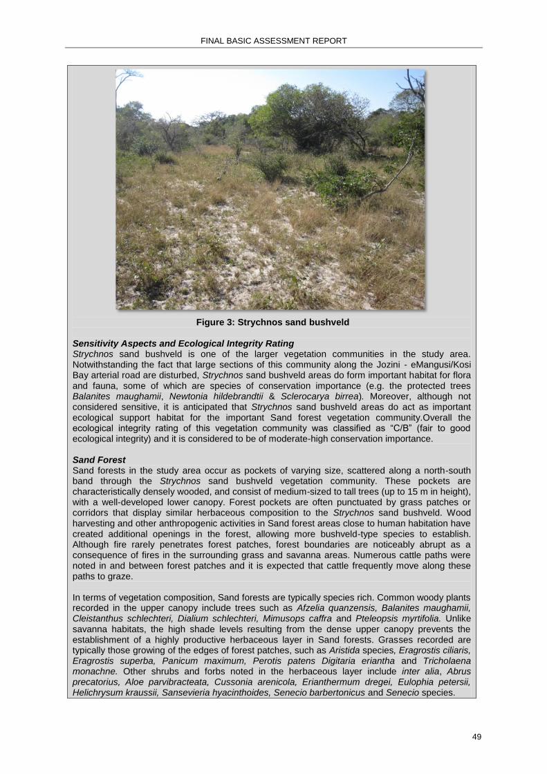
FINAL BASIC ASSESSMENT REPORT
49
Figure 3: Strychnos sand bushveld
Sensitivity Aspects and Ecological Integrity Rating Strychnos sand bushveld is one of the larger vegetation communities in the study area. Notwithstanding the fact that large sections of this community along the Jozini - eMangusi/Kosi Bay arterial road are disturbed, Strychnos sand bushveld areas do form important habitat for flora and fauna, some of which are species of conservation importance (e.g. the protected trees Balanites maughamii, Newtonia hildebrandtii & Sclerocarya birrea). Moreover, although not considered sensitive, it is anticipated that Strychnos sand bushveld areas do act as important ecological support habitat for the important Sand forest vegetation community.Overall the ecological integrity rating of this vegetation community was classified as “C/B” (fair to good ecological integrity) and it is considered to be of moderate-high conservation importance. Sand Forest Sand forests in the study area occur as pockets of varying size, scattered along a north-south band through the Strychnos sand bushveld vegetation community. These pockets are characteristically densely wooded, and consist of medium-sized to tall trees (up to 15 m in height), with a well-developed lower canopy. Forest pockets are often punctuated by grass patches or corridors that display similar herbaceous composition to the Strychnos sand bushveld. Wood harvesting and other anthropogenic activities in Sand forest areas close to human habitation have created additional openings in the forest, allowing more bushveld-type species to establish. Although fire rarely penetrates forest patches, forest boundaries are noticeably abrupt as a consequence of fires in the surrounding grass and savanna areas. Numerous cattle paths were noted in and between forest patches and it is expected that cattle frequently move along these paths to graze. In terms of vegetation composition, Sand forests are typically species rich. Common woody plants recorded in the upper canopy include trees such as Afzelia quanzensis, Balanites maughamii, Cleistanthus schlechteri, Dialium schlechteri, Mimusops caffra and Pteleopsis myrtifolia. Unlike savanna habitats, the high shade levels resulting from the dense upper canopy prevents the establishment of a highly productive herbaceous layer in Sand forests. Grasses recorded are typically those growing of the edges of forest patches, such as Aristida species, Eragrostis ciliaris, Eragrostis superba, Panicum maximum, Perotis patens Digitaria eriantha and Tricholaena monachne. Other shrubs and forbs noted in the herbaceous layer include inter alia, Abrus precatorius, Aloe parvibracteata, Cussonia arenicola, Erianthermum dregei, Eulophia petersii, Helichrysum kraussii, Sansevieria hyacinthoides, Senecio barbertonicus and Senecio species.

FINAL BASIC ASSESSMENT REPORT
50
Figure 4: Sand forest
Sensitivity Aspects and Ecological Integrity Rating The Sand forest vegetation community is considered the most valuable and rarest in Maputaland, having high levels of both flora and fauna (Gaugris & Van Rooyen, 2008), and a number of species listed as Red Data and/or protected. Patches of Sand forest along the Jozini - eMangusi arterial road show signs of localised anthropogenic disturbances associated with timber harvesting. Be that as it may, the ecological integrity, of undisturbed patches of this vegetation community, is classified as “A” (excellent ecological integrity). This vegetation community is considered threatened and sensitive to additional degradation and fragmentation. Accordingly, is regarded as being of high the conservation importance and measures should be taken to minimise additional disturbances. Mixed Bushveld Mixed Bushveld extends from the edge of the Pongola River riparian zone westward. The soils of this vegetation community are noticeably less sandy than the other communities, having a red colour, a firmer structure and ostensibly higher clay content. The vegetation composition of upland areas is mixed, but generally dominated by broad-leafed woody species (height 2 to 4m), most notably Carissa bispinosa, Canthium inerme, Combretum molle, Croton pseudopulchellus and Terminalia sericea. Common herbaceous species, in the upland areas, include the grasses Aristida congesta subsp. barbicollis, Dactyloctenium australis, Sida dregei, Tricholaena monachne, Aristida congesta, subsp. barbicollis, Panicum maximum, Perotis patens, Themeda triandra and Tragus berteronianus, as well as the forbs Asparagus setaceus, Kalanchoe brachyloba and Sansevieria hyacinthoides.

FINAL BASIC ASSESSMENT REPORT
51
Figure 5: Upland area of the Mixed bushveld vegetation community
From the upland areas, the clay content of the soil gradually increases toward the low-lying areas adjacent to the Pongola River riparian zone. This is reflected in a gradual transition in the woody species composition from broad-leaf to fine-leaf dominated species, with species such as Acacia nilotica, Acacia tortilis, Acacia xanthophloea, Albizia anthelmintica and Dichrostachys cinerea becoming particularly dominant Other woody species recorded in the low lying zones that were not noted/common in upland areas include Aloe parvibracteata, Azima tetracantha, Balanites maughamii, Brachylaena huilensis, Commiphora neglecta, Croton steenkampianus, Euclea undulata, Grewia microthyrsa, Gymnosporia buxifolia, Maerua caffra, Maerua decumbens, Manilkara mochisia, Newtonia hildebrandtii, Salvadora australis, Schotia brachypetala, Senna petersiana, Strychnos decussata and Trichilia emetica. In low lying areas of this vegetation community, the annual grass Sporobolus nitens is particularly common. This species is abundant in disturbed veld which indicates the overgrazing is taking place. Other herbaceous species recorded include Adenium multiform, Argemone mexicana*, Chromolaena odorata*, Gomphocarpus fruticosus subsp. decipiens, Cissus cactiformis, Sida cordifolia, Solanum panduriforme and Tribulus terrestris, while Litogyne gariepina and Pechuel-Loeschea leubnitziae and Sesbania bispinosa were recorded in ephemeral water-filled depressed areas. (Note:* deonotes alien invader species).

FINAL BASIC ASSESSMENT REPORT
52
Figure 6: Low lying areas of Mixed bushveld – note sparse grass
cover and dominance of Sporobolus nitens
Sensitivity Aspects and Ecological Integrity Rating Areas of Mixed bushveld are heavily utilised by the rural community for inter alia grazing and firewood. This notwithstanding, they do form important habitat for flora and fauna, some of which are species of conservation importance (e.g. Balanites maughamii & Boscia albitrunca). The ecological integrity rating of non-transformed areas of this vegetation community was classified as “C/B” (fair to good ecological integrity) and it is considered to be of moderate conservation importance. Riparian vegetation community The Riparian vegetation community is centred on the Pongola River, which is located on the western edge of the study area. Large areas of the Pongola River embankment and associated floodplains have been cleared of natural vegetation by the local communities and used to grow agricultural crops. As such, much of the Pongola River riparian vegetation community in the study area is disturbed and highly fragmented. Woody plants are generally confined to the immediate river banks or in areas between cultivated fields, and comprise a mixture of tall (> 6 m) obligate riparian species in the upper canopy (e.g. Ficus sycomorus) and smaller ( 3 m) species growing lower shrub layer. Tall trees contributing to the upper canopy include Acacia robusta, Acacia xanthophloea, Albizia versicolor, Faidherbia albida, Ficus sycomorus, Garcinia livingstonei, Kigelia africana, Sclerocarya birrea, Schotia brachypetala, Spirostachys africana, Trichilia emetica and Ziziphus mucronata. Numerous exotic Mango (Mangifera indica) trees were also recorded growing in the cultivated fields adjacent to the river. Where not disturbed or cleared, woody species recorded in the lower shrub layer are include Acacia schweinfurthii, Acacia tortilis, Dichrostachys cinerea, Euclea divinorum, Grewia flavescens, Grewia villosa, Gymnosporia senegalensis, Phoenix reclinata, Phyllanthus pinnatus, Phyllanthus reticulatus and Tabernaemontana elegans.

FINAL BASIC ASSESSMENT REPORT
53
Figure 7: Riparian vegetation community along the Pongola River.
As a consequence of the high levels of disturbance, the herbaceous layer comprises a mixture of indigenous and exotic species, such as inter alia, Argemone mexicana*, Chromolaena odorata*, Cynodon dactylon, Cyperus species, Eragrostis ciliaris, Gomphocarpus fruticosus subsp. decipiens, Gossypium herbaceum subsp. africanum, Imperata cylindrica, Leonotis intermedia, Panicum maximum, Pechuel-Loeschea leubnitziae, Phragmites australis, Ricinus communis var. communis*, Sesbania bispinosa *, Sida cordifolia, Sorghum species, Strelitzia nicolai and Xanthium strumarium*.
Figrue 8: Floodplain of the Pongola River cleared and used for crop cultivation
Sensitivity Aspects and Ecological Integrity Rating
FINAL BASIC ASSESSMENT REPORT
54
Subsistence agriculture has transformed and disturbed large sections of the Pongola River
floodplain comprising the riparian vegetation community. This notwithstanding, riparian areas do
form critical fauna and flora habitat and provide important movement and dispersal corridors.
Moreover, flora species of conservation importance (e.g. Sclerocarya birrea & Spirostachys
africana) were also noted in this vegetation community. The ecological integrity of this vegetation
community was classified as “C” (fair ecological integrity). However, Riparian vegetation
community is sensitive and considered of high conservation Measures should be taken to
minimise additional disturbances.
The Ecological Report is presented in Appendix D1 and Maps showing Ecological zones and
sensitivities are presented in Appendix A4.
SECTION C: PUBLIC PARTICIPATION
1. ADVERTISEMENT AND NOTICE
Publication name The Mercury
The Zululand Observer
Vryheid Herald
Date published 22 February 2012
24 February 2012
24 February 2012
Site notice position Latitude Longitude See Appendix E1.
Date placed 19-23 February 2013
Publication name The Mercury
Date published 18 November 2013
Site notice position Latitude Longitude See Appendix E1
Date placed 18-22 November 2013
Include proof of the placement of the relevant advertisements and notices in Appendix E1. Copies of the advertisements placed in the newspapers and photographed locations of the site
notices are presented in Appendix E1.
2. DETERMINATION OF APPROPRIATE MEASURES Provide details of the measures taken to include all potential I&APs as required by Regulation 54(2)(e) and 54(7) of GN R.543. Key stakeholders (other than organs of state) identified in terms of Regulation 54(2)(b) of GN R.543:
Title, Name and Surname Affiliation/ key stakeholder status
Contact details (tel number or e-mail address)
Please see Appendix E2 for a complete list of the Key Stakeholders.
Include proof that the key stakeholder received written notification of the proposed activities as Appendix E2. This proof may include any of the following:

FINAL BASIC ASSESSMENT REPORT
55
e-mail delivery reports;
registered mail receipts;
courier waybills;
signed acknowledgements of receipt; and/or
or any other proof as agreed upon by the competent authority. Proof of Notification of Key Stakeholders is presented in Appendix E2.
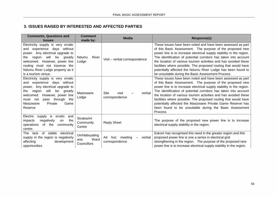
FINAL BASIC ASSESSMENT REPORT
56
3. ISSUES RAISED BY INTERESTED AND AFFECTED PARTIES
Comments, Questions and
Issues
Comment
made by: Media Response(s)
Electricity supply is very erratic
and experience days without
power. Any electrical upgrade to
the region will be greatly
welcomed. However, power line
routing must not traverse the
Ndumu River Lodge property as it
is a tourism venue.
Ndumu River
Lodge Visit – verbal correspondence
These issues have been noted and have been assessed as part
of this Basic Assessment. The purpose of the proposed new
power line is to increase electrical supply stability in the region.
The identification of potential corridors has taken into account
the location of various tourism activities and has avoided these
facilities where possible. The proposed routing that would have
potentially affected the Ndumu River Lodge has been found to
be unsuitable during the Basic Assessment Process.
Electricity supply is very erratic
and experience days without
power. Any electrical upgrade to
the region will be greatly
welcomed. However, power line
must not pass through the
Masizwane Private Game
Reserve
Masizwane
Lodge
Site visit – verbal
correspondence
These issues have been noted and have been assessed as part
of this Basic Assessment. The purpose of the proposed new
power line is to increase electrical supply stability in the region.
The identification of potential corridors has taken into account
the location of various tourism activities and has avoided these
facilities where possible. The proposed routing that would have
potentially affected the Masizwane Private Game Reserve has
been found to be unsuitable during the Basic Assessment
Process.
Electric supply is erratic and
impacts negatively on the
operations of the community
centre.
Sicabazini
Community
Centre
Reply Sheet The purpose of the proposed new power line is to increase
electrical supply stability in the region.
The lack of stable electrical
supply in the region is negatively
affecting development
opportunities.
Umhlabuyaling
ana Ward
Councillors
Ad hoc meeting – verbal
correspondence
Eskom has recognised this need in the greater region and this
proposed power line is one a series in electrical grid
strengthening in the region. The purpose of the proposed new
power line is to increase electrical supply stability in the region.

FINAL BASIC ASSESSMENT REPORT
57
Comments, Questions and
Issues
Comment
made by: Media Response(s)
The proposed town planning
scheme for Phelendaba area
must be taken into account when
locating the power line.
Umhlabuyaling
ana Ward
Councillor 11
Ad hoc meeting – verbal
correspondence
During the identification of the potential power line corridors, the
proposed planning scheme for Phelendaba was consulted.
However, final comment will be provided by the Umhlabuyalinga
Town Planner during the Draft BAR comment period and that
comment will be addressed and form part of the Final BAR and
final alignment of the proposed power line.
The lack of stable electrical
supply in the region is negatively
affecting development
opportunities. The time taken by
Eskom to deliver the new power
lines is a concern as the power
improvements are urgently
needed.
Technical
Services
Manager –
Umhlabuyaling
ana Local
Municipality
(LM)
Meeting – verbal
correspondence
Eskom has recognised this need in the greater region and this
proposed power line is one a series in electrical grid
strengthening in the region. The purpose of the proposed new
power line is to increase electrical supply stability in the region.
Eskom has prioritised this project, but the environmental
assessment process is partly responsible for the delays.
The proposed power line routing
must be in keeping with the town
planning scheme for the region.
Technical
Services
Manager –
Umhlabuyaling
ana LM
Meeting – verbal
correspondence
The Draft BAR showing the proposed alignments will be
presented to the Umhlabuyalingana LM Town Planners for
comment.
There is strong support for the project from the mayor’s office and the local councillors present. The Honourable Mayor emphasised that the region has been waiting for the provision of electricity from Eskom for a while now. The mayor urged the EAP to accelerate the authorisation process.
Honourable
Mayor -
Umhlabuyaling
ana LM
Focus Group Meeting Noted
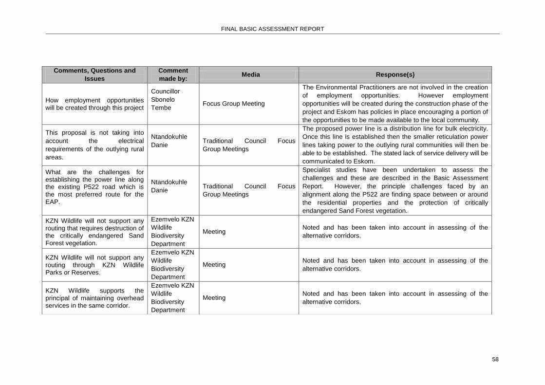
FINAL BASIC ASSESSMENT REPORT
58
Comments, Questions and
Issues
Comment
made by: Media Response(s)
How employment opportunities will be created through this project
Councillor
Sbonelo
Tembe
Focus Group Meeting
The Environmental Practitioners are not involved in the creation
of employment opportunities. However employment
opportunities will be created during the construction phase of the
project and Eskom has policies in place encouraging a portion of
the opportunities to be made available to the local community.
This proposal is not taking into
account the electrical
requirements of the outlying rural
areas.
Ntandokuhle
Danie
Traditional Council Focus
Group Meetings
The proposed power line is a distribution line for bulk electricity.
Once this line is established then the smaller reticulation power
lines taking power to the outlying rural communities will then be
able to be established. The stated lack of service delivery will be
communicated to Eskom.
What are the challenges for establishing the power line along the existing P522 road which is the most preferred route for the EAP.
Ntandokuhle
Danie
Traditional Council Focus
Group Meetings
Specialist studies have been undertaken to assess the
challenges and these are described in the Basic Assessment
Report. However, the principle challenges faced by an
alignment along the P522 are finding space between or around
the residential properties and the protection of critically
endangered Sand Forest vegetation.
KZN Wildlife will not support any routing that requires destruction of the critically endangered Sand Forest vegetation.
Ezemvelo KZN
Wildlife
Biodiversity
Department
Meeting Noted and has been taken into account in assessing of the
alternative corridors.
KZN Wildlife will not support any routing through KZN Wildlife Parks or Reserves.
Ezemvelo KZN
Wildlife
Biodiversity
Department
Meeting Noted and has been taken into account in assessing of the
alternative corridors.
KZN Wildlife supports the principal of maintaining overhead services in the same corridor.
Ezemvelo KZN
Wildlife
Biodiversity
Department
Meeting Noted and has been taken into account in assessing of the
alternative corridors.

FINAL BASIC ASSESSMENT REPORT
59
Comments, Questions and
Issues
Comment
made by: Media Response(s)
In correspondence received from the Ezemvelo KwaZulu Natal Wildlife a number of recommendations and issues requiring clarification was pointed out. The following issues were raised:
The Basic Assessment Report does not clearly indicate how the alternatives referred to in the specialists reports relate to the revised alternatives in the BAR, as they do not have the same names nor make reference to each other.
Clarity regarding the preferred alternative 3P is required.
A concern is that none of the maps included in the BAR clearly indicate the preferred 3P alignment (as only minor fragment can be seen and not the entire length).
A clear description and illustration of the proposed alternatives, in particular the preferred alternative is included in the BAR, to allow for informed and defensible decision making (particularly as it is the maps contained in the BAR that would be included in the Environmental Authorisation, should authorisation be granted, and no the .shp files provided for
Ezemvelo KZN
Wildlife
Biodiversity
Department
Email – 09 May 2014
Response by EAP: The issues that have been raised by the Ezemvelo KwaZulu Natal Wildlife have been addressed by means of the following:
The Specialist Studies (Avifaunal and Terrestrial Ecology Study) have been amended to ensure that the alternatives referred to in both these reports corresponds with the alternatives described in the final Basic Assessment Report.
A Description of Preferred Alternative 3P is provided in Section 2(b) Lay-out Alternatives of the final Basic Assessment Report.
All maps included as Appendices to the final Basic Assessment Report have been amended to clearly show Alternative A1 (Preferred Alternative Corridor 3P), Alternative A2 (Corridor 3A), Alternative A3 (Corridor 3B) and Alternative A3 (Corridor 3C).
All mitigation measures provided in the Terrestrial Ecology Study have been included in both the final Basic Assessment Report as well as the Environmental Management Programme. The proponent will be required to ensure that all mitigation measures provided in the EMPr are adhered to throughout the project lifecycle.
Ezemvelo KwaZulu Natal Wildlife will be provided with an electronic copy of the amended final Basic Assessment Report and associated Appendices for review.

FINAL BASIC ASSESSMENT REPORT
60
assessment in ArcView).
Given the extremely sensitive nature of the landscape associated with the proposed project, it is strongly recommended that the Final BAR for the proposed project explicitly and clearly indicate in both the maps and the report the preferred Alternative 3P route as well as the relation of the preferred alternatives to other assessed alternatives.
Final comment from Ezemvelo KwaZulu Natal Wildlife will be provide once the requested information have been received.
In the correspondence received from the KwaZulu Natal Department of Agriculture, Environmental Affairs and Rural Development the following comments were included:
Only final Specialist Studies must be included in the amended final Basic Assessment Report.
Ezemvelo KwaZulu Natal Wildlife must be consulted with regards to the Protected Areas Expansion Stratgey and Biodiversity Stewardship Programme.
All recommendations and mitigation measures that have been included in the EMPr must stringently be adhered to.
KwaZulu Natal
Department of
Agriculture,
Environmental
Affairs and
Rural
Development
Facsimile received on
13 May 201.
Comments regarding the proposed project have been received from the Ezemvelo KwaZulu Natal Wildlife (dated 09 May 2014). These comments did however make no reference to the Protected Areas Expansion Stratgey and Biodiversity Stewardship Programme.
The proponent will be required to adhere to all mitigation measures that are included in the EMPr provided that Environmental Authorisation is granted.
All final Specialist Studies will be included in the amended final Basic Assessment Report.
As per the information received from Ezemvelo KZN (letter dated 12 September 2014) note is taken that the Tshanini-Bhekula Community Reserve and Bhekabantu Community Conseration area forms part of theEzemvelo KZN Wildlife Biodiversity Stewardship Programme.

FINAL BASIC ASSESSMENT REPORT
61
4. COMMENTS AND RESPONSE REPORT
The practitioner has recorded all comments received from I&APs and responded to each comment for inclusion into
the Final BAR for submission to DEA. The comments and responses are captured in a comments and response
report as prescribed in the EIA regulations and be attached to the Final BAR as Appendix E3. The I&AP Comment and Response Report is presented in Appendix E3.

FINAL BASIC ASSESSMENT REPORT
62
5. AUTHORITY PARTICIPATION
Authorities and organs of state identified as key stakeholders:
Authority/Organ of State
Contact person (Title, Name
and Surname) Tel No Fax No E-mail Postal address
Department of Water Affairs (DWA)
Mr Thys Badenhorst
(031) 336-2783 (031) 307-7279 [email protected]
Chief Director: KZN Region Department of Water Affairs (DWA) P O Box 1018 DURBAN 4000
Department of Co-operative Governance & Traditional Affairs
Sipho Buthelezi (034) 312-5380 Department of Co-operative Governance & Traditional Affairs (KZN) Private Bag X9078 PIETERMARITZBURG 3200
Department of Economic Development and Tourism
Ms Carol Coetzee
(033) 264-2500 (033) 264-2580 [email protected]
Head of Department Economic Development and Tourism Private Bag X9152 PIETERMARITZBURG 3201
Zululand District Municipality
Mr Johannes de Klerk
(035) 874 5500 (035) 874 5589/91 [email protected]
Municipal Manager Zululand District Municipality Private Bag X76 ULUNDI3838
Ezemvelo KZN Wildlife
Ms Dinesree Thambu
(033) 845-1425 (033) 845-1499 [email protected]
Principal Conservation Planner Ezemvelo KZN Wildlife P O Box 13053 CASCADES 3202
uPhongolo Local Municipality
Mrs F Jardim (034) 413-1223 (034) 413-1706 [email protected]
Municipal Manager uPhongolo Local Municipality P O Box 191 PONGOLA 3170
Department of Agriculture, Forestry and Fisheries
Mr Makhosi Mdamba
(035) 780-6700 (035) 789-0662 [email protected]
Department of Agriculture, Forestry and Fisheries (KZN) 65 Victor Street DUNDEE

FINAL BASIC ASSESSMENT REPORT
63
Authority/Organ of State
Contact person (Title, Name
and Surname) Tel No Fax No E-mail Postal address
Kwanyawo Traditional Council
Mr Thandukuhle Zwane
082 773 3146 Kwanyawo Traditional Council P O Box 141 INGWAVUMA 3968
Mathenjwa Traditional Council
Mr Thandukuhle Mathenjwa
072 548 5515 [email protected] Mathenjwa Traditional Council Private Bag X2247 INGWAVUMA 3968
Mathenjwa Traditional Council
Mrs Violah Mathenjwa
076 169 5202 Mathenjwa Traditional Council Private Bag X2247 INGWAVUMA 3968
Mathenjwa Traditional Council
Mrs Lilian Mathenjwa
079 405 2808 Mathenjwa Traditional Council Private Bag X2247 INGWAVUMA 3968
Department of Co-operative Governance & Traditional Affairs
Mrs R. T. Mthembu
076 774 9234 035 573 1744
Department of Co-operative Governance & Traditional Affairs Private Bag X503 MKHUZE 3965
uMhlabuyalingana Local Municipality
Councillor Sbonele Tembe
073 424 0916 [email protected] P O Box 536 KWANGWANASE 3973
uMhlabuyalingana Local Municipality
Councillor N. C. Mdletshe
079 6161729 [email protected] P O Box SIBHAYI 3967
uMhlabuyalingana Local Municipality
Councillor B. H. Ngubane
079 111 0787 P O Box 69 KWANGWANASE 3973
uMhlabuyalingana Local Municipality
Councillor T. U. Gumede
072 587 8744 P O Box 4418 KWANGWANASE 3973
Department of Agriculture Forestry and Fisheries
012 319 6000 Private Bag X250, Pretoria, 0001
Jozini Local Municipality

FINAL BASIC ASSESSMENT REPORT
64
Authority/Organ of State
Contact person (Title, Name
and Surname) Tel No Fax No E-mail Postal address
Amafa KwaZulu Natal
Bernadette Pawandiwa
033 394 6543 - [email protected] -

FINAL BASIC ASSESSMENT REPORT
65
Include proof that the Authorities and Organs of State received written notification of the proposed activities as
appendix E4. The proof of notification of Authorities and Organs of state is presented in Appendix E4, E4a &
E4b.
In the case of renewable energy projects, Eskom and the SKA Project Office must be included in the list of
Organs of State. Note: In response to the correspondence received from the Department of Environmental Affairs
dated 22 April 2014, additional engagement with specific Commenting Authorities have been
carried out. The Environmental Assessment Practitioner was requested to approach and provide
comments received from the Department of Agriculture, Forestry and Fisheries specific to the
impact of the proposed project on the Sand Forest and to confirm the boundaries of the Protected
Areas Expansion Strategy and Biodiversity Stewardship Programme sites in relation to the
proposed corridors. Furthermore the DEA also requested that comments relating to the final BAR
be obtained from the following authorities:
KwaZulu Natal Department of Agriculture and Environmental Affairs.
Ezemvelo KwaZulu Natal Wildlife.
Department of Water Affairs.
Jozini Local Municipality.
Umhlabuyalingana Local Municipality.
Provincial Heritage Resources Agency.
All comments that have been provided by the above mentioned Commenting Authorities have been
collated in the Comments and Response Report (refer to Appendix E3). Furthermore all
correspondence between the EAP and the particular Commenting Authorities is included in this
report as Appendix E2. Comments have not been received from the Umhlabuyalingana Local
Municipality and the South African Heritage Resources Agency. However correspondence sent to
the the Umhlabuyalingana Local Municipality and the South African Heritage Resources Agency
requesting comments on the proposed project have been included in Appendix E2.
6. CONSULTATION WITH OTHER STAKEHOLDERS
Note that, for any activities (linear or other) where deviation from the public participation requirements may be
appropriate, the person conducting the public participation process may deviate from the requirements of that
sub-regulation to the extent and in the manner as may be agreed to by the competent authority.
Proof of any such agreement must be provided, where applicable. Application for any deviation from the
regulations relating to the public participation process must be submitted prior to the commencement of the
public participation process.
A list of registered I&APs must be included as appendix E5.
A list of registered I&APs is included in Appendix E5.
Copies of any correspondence and minutes of any meetings held must be included in Appendix E6.
Copies of correspondence and meetings are included in Appendix E6.

FINAL BASIC ASSESSMENT REPORT
66
SECTION D: IMPACT ASSESSMENT
The assessment of impacts must adhere to the minimum requirements in the EIA Regulations, 2010, and should
take applicable official guidelines into account. The issues raised by interested and affected parties should also
be addressed in the assessment of impacts.
1. IMPACTS THAT MAY RESULT FROM THE PLANNING AND DESIGN,
CONSTRUCTION, OPERATIONAL, DECOMMISSIONING AND CLOSURE
PHASES AS WELL AS PROPOSED MANAGEMENT OF IDENTIFIED
IMPACTS AND PROPOSED MITIGATION MEASURES
Provide a summary and anticipated significance of the potential direct, indirect and cumulative impacts that
are likely to occur as a result of the planning and design phase, construction phase, operational phase,
decommissioning and closure phase, including impacts relating to the choice of site/activity/technology
alternatives as well as the mitigation measures that may eliminate or reduce the potential impacts listed.
This impact assessment must be applied to all the identified alternatives to the activities identified in Section
A(2) of this report. The detailed Environmental Impact Assessment Matrix is presented in Appendix F and the
findings are summarised in the following tables:

FINAL BASIC ASSESSMENT REPORT
67
PLANNING AND DESIGN PHASE
Activity Impact summary
Pre-mitigation Significance Proposed mitigation
Post-Mitigation Significance Impact Statement
A1 A2 A3 A4 A1 A2 A3 A4
Heritage Sites
Direct impacts: Damage to heritage and archaeological sites as a result of position of the towers.
L- L- M- M-
Select route within corridor least likely to impact on heritage sites. Appoint heritage specialist at design phase to assist with identification of sites and placement of towers. Avoid location of towers on or near heritage sites. There is a high possibility that fossils could be encountered during excavation of the Uloa and Mzinene Formations and there is a good possibility of uncovering root structures and fossilised wood during excavation of the Muzi and Berea Formations. There is thus a good possibility of finding fossils during the excavation of pylon foundations.
L- L- L- L-
Heritage sites of various significance were identified in close proximity to all the proposed corridor alignments. However, implementation of the proposed mitigation measures will result in the potential negative impact being of LOW significance for all 4 corridors.
Direct impacts: Damage to heritage sites and archaeological sites as a result of the alignment of access roads.
M- M- M- M-
Ensure access plan detailing exact access routes is developed prior to construction. Appoint heritage specialist to review proposed access plan and routes to verify that they do not pass through or close to heritage sites. The movement of
L- L- L- L-
Heritage sites of various significance were identified in close proximity to all the proposed corridors. However, the implementation of the proposed mitigation measures will result in the potential impact being of LOW significance for all 4 corridors.

FINAL BASIC ASSESSMENT REPORT
68
Activity Impact summary Pre-mitigation Significance
Proposed mitigation Post-Mitigation
Significance Impact Statement
heavy machinery and vehicles over unexposed heritage or palaeontology resources may damage the resources.
Direct impacts: Bird electrocutions
L- L- L- L-
A tower design which poses the least risk of bird electricution and which provides the least area available for perching should be selected (i.e. a bird friendly tower structure);
It is highly recommended that the steel monopole design be used and that structure incorporates the standard bird perch. The standard bird perch included in the monopole structure will allow most raptors and birds of high electrocution risk to perch well above the conductors;
To accommodate the largest bird wing span, all clearances between live and earth components should be 1.8 m for steel lattice towers and 1.5m for steel monopoles;
Existing power line routes should as far as possible be followed to increase visibility of the power line structure;
L- L- L- L-
Electrocution is possible on a 132kV power line, especially where large raptors and vultures feature prevalently. Fortunately, it is unlikely that vultures will occur in the study area but numerous large eagles and buzzards may be present, so the impact of electrocution is likely to be of Low Significance across all alternatives for the proposed power line if the proposed mitigations are implemented.

FINAL BASIC ASSESSMENT REPORT
69
Activity Impact summary Pre-mitigation Significance
Proposed mitigation Post-Mitigation
Significance Impact Statement
Ensure that suitable bird repelling structure, such as bird guards are considered in the design; and
The further design option of a steel lattice tower with horizontal configuration as opposed to a delta configuration is the most preferable. This tower type may be construed as being more visually intrusive as the cross-arm is longer and its use will be more costly than the delta configuration.
Direct impacts: Avifaunal habitat destruction due to vegetation clearance
L- L- H- H-
Select corridor requiring the least amount of clearing of indigenous bush for access construction and maintenance; and
Vegetation clearing should be: o Limited to 16 m within
the working area; and o Vegeation should only
be removed from the minimum required construction and / or working area, within the servitude.
L- L- M- M-
Due to the fact that Corridors 3P and 3A are located within areas where anthropogenic settlement has already resulted on habitat destruction the expected impact of a power line of either of these corridors is expected to be low. Corridors 3B and 3C are located on the fringes of human settlements and there is more likelihood of requiring a greater degree of removal of indigenous vegetation to create the cleared servitude and access routes.
Direct impacts: Disturbance of breeding activities
L- L- M- M-
Select Corridor with least potential to impact on breeding activities of endemic birds. Appoint specialist during final positioning and alignment of
L- L- L- L-
Due to the fact that Corridors 3P and 3A are located within areas where anthropogenic settlement it as anticipated that roosting and nesting bird species have

FINAL BASIC ASSESSMENT REPORT
70
Activity Impact summary Pre-mitigation Significance
Proposed mitigation Post-Mitigation
Significance Impact Statement
power line in order to assist with identification of roosts or nests in order to attempt to avoid these where practically possible.
avoided these areas. Corridors 3B and 3C are located on the fringes of human settlements and there is more likelihood of the existence of bird roosts or breeding nests in these less disturbed areas
Social and Socio-economic
Direct Impacts: Visual impact on tourism route/operations and residential homes
H- H- M- M-
Ensure that as much as possible natural vegetation should be retained within the corridor to ensure once the servitude is visual screening of the power line by the vegetation.
M- M- L- L-
Corridors 3P and 3A will be highly visible along the P522 and the associated ribbon developments while Corridors 3B and 3C will be less visible due to screening that will be provided by forest vegetation between the road, associated ribbon development and the proposed power line corridors. However, a visual impact already occurs along Corridors 3P and 3A due to the presence of ribbon development and the existing 22kV power line and the impact is currently being assimilated to a degree. Whereas these will be totally new negative impacts to Corridors 3B and 3C. Most biophysical impacts compound one another, however in the case of visual impact, often stakeholders prefer to have impacts in areas of existing impact.
Vegetation
Direct impacts: Increased potential for loss of indigenous vegetation due to
M- M- H- H-
Select corridor and route least likely to impact on indigenous vegetation.
L- L- M- M-
The following natural bush clearing will be required for each of the corridors: 3P - 19.04 km; 3A - 17.82 km; 3B - 25.43 km;

FINAL BASIC ASSESSMENT REPORT
71
Activity Impact summary Pre-mitigation Significance
Proposed mitigation Post-Mitigation
Significance Impact Statement
alignment of power line and position of towers.
Where possible locate towers and alignment in areas of least dense indigenous vegetation and tree cover to minimise the amount of bush clearing required;
All efforts should be made to select a route which require the least clearing of species forming part of the vegetation community, where the loss of vegetation have been rated as a high significance impact (e.g. Sand Forest) (refer to Appendix D1);
A specialist botanist should be appointed during the design phase to assist with the final alignment of the power-line in the approved corridor to minimise or avoid placement of the power-line through sensitive vegetation (such as Sand Forest) where possible.
3C - 24.83 km. Corridor 3A will require the least amount of clearing of indigenous bush as it is located closer to the P522 road within the ribbon development zone wherein most of the natural vegetation has already been cleared for development. Corridor 3P lies on the fringe of the development zone and requires a little more bush clearing. Corridors 3B and 3C traverse large areas of undisturbed natural bush which has not been impacted on by development.
Direct impacts: Increased potential for loss of species biodiversity due to alignment of power line and position of towers
M- L- H- H-
Select corridor with least potential to impact on critically endangered Sand Forest. Where possible locate towers and alignment in areas and habitats identified as consisting of species
L- L- M- M-
The vegetation mapping shows that all the potential corridors pass through Sand Forest communities. However, on the ground studies have shown that the Sand Forest Communities and ecotypes in Corridor 3P and 3A have been impacted on by

FINAL BASIC ASSESSMENT REPORT
72
Activity Impact summary Pre-mitigation Significance
Proposed mitigation Post-Mitigation
Significance Impact Statement
typical and numerous in the area. Make use of specialist during alignment to do this and to avoid Sand Forest communities.
A specialist botanist should be appointed during the design phase to assist with the final alignment of the power-line in the approved corridor to minimise or avoid placement of the power-line through sensitive vegetation (such as Sand Forest) where possible.
anthropogenic activity and it may be possible to select an alignment that can avoid these remnant communities in both these corridors. The Sand Forest Communities and other ecotypes along corridors 3B and 3C are relatively intact and it will be difficult to avoid taking a power line through them.
Direct Impacts: Increased potential for loss of rare or endangered species due to alignment of power line and position of towers.
M- L- H- H-
Select corridor with least potential to impact on critically endangered Sand Forest. Where possible locate towers and alignment in areas identified as consisting of species typical and numerous in the area. Make use of specialist during alignment to do this and to avoid Sand Forest communities.
L- L- M- M-
The vegetation mapping shows that all the potential corridors pass through Sand Forest communities. However, on the ground studies have shown that the Sand Forest Communities and ecotypes in Corridor 3P and 3A have been impacted on by anthropogenic activity and it may be possible to select an alignment that can avoid these remnant communities in both these corridors. The Sand Forest Communities and other ecotypes along corridors 3B and 3C are relatively intact and it will be difficult to avoid taking a power line through them.
Wetland Impacts
Direct Impacts: Impact of power line
L- L- L- L- No other structures, apart
from a single elongated L- L- L- L-
Corridors 3P, 3B and 3C will all cross the Pongola River at

FINAL BASIC ASSESSMENT REPORT
73
Activity Impact summary Pre-mitigation Significance
Proposed mitigation Post-Mitigation
Significance Impact Statement
on Pongola River and impact of Pongola River flow on power line.
platform within the the floodplain on the North-Western side of the Makhanye’s Drift, may be constructed within the 1:100 year floodline;
The design of the towers must take cogniscance of the impact of Pongola River flow on power line and ensure that the structure can withstand the velocity and volume of flow;
Use existing river crossings where possible;
The working area within riparian areas should be confined the smallest possible area.
Makhane's drift. Corridor 3A proposed tp cross the Pongola River at parallel to the P522 road bridge where the existing 22kV crosses. The Makhane's Drift crossing is considered preferable due to a narrower flood plain and the availability of high ground which will permit easy spanning of the floodplain.
Direct Impacts: Pongola River crossing – impact on riverine vegetation
M- M- M- M-
Select power line route alignment with least potential to impact on riverine vegetation; and
Avoid impacts to wetlands and perennial rivers as far as possible.
L- L- L- L-
In the case of all the corridors, agriculture has already caused the approaches to the rivers in the floodplains to be cleared of most vegetation and there is evidence of alien species infestation. The impact of the power line on riverine vegetation is expected to be low for all potential corridors.
Direct Impacts: Damage to Muzi wetlands through direct impact or associated run-off impacts
M- M- M- M-
Select corridor traversing wetlands in those areas where the wetlands have already been subjected to a high level of anthropogenic transformation or degradation. Use findings of
L- L- L- L-
All the corridors traverse the extensive wetland systems in the eastern portion of the study area. However, Corridors 3P and 3A traverse these wetlands in areas where they have already been substantially

FINAL BASIC ASSESSMENT REPORT
74
Activity Impact summary Pre-mitigation Significance
Proposed mitigation Post-Mitigation
Significance Impact Statement
specialist study to select power line route alignment within corridor with least potential to impact on water sources and to assist in placement of the towers to as far as possible avoid these features; and
No-go areas should be clearly demarcated for the duration of the Construction Phase. No activities or movement within the no-go areas will be permitted;
The DWA should be consulted to determine any specific requirements regarding undertaking construction activities within the extent of watercourses and floodplains during controlled events;
Regular inspection of all activities which are carried out within close proximity to watercourses, must be done by a ECO; and
All reasonable measures should be taken to prevent adverse impacts on all watercourses which are associated with the proposed project.
transformed and impacted on anthropogenic activities and hence the impact of the power line along either of these two corridors is expected to be less than for Corridors 3B and 3C where the wetlands are less impacted on and closer to their natural functioning.
Visual Direct Impacts: Pylons become visually dominant on
H- H- L- L- Select corridor and power
line route alignment which is least likely to create a
L- L- L- L-
Corridors 3P and 3A will be highly visible along the P522 and the associated ribbon

FINAL BASIC ASSESSMENT REPORT
75
Activity Impact summary Pre-mitigation Significance
Proposed mitigation Post-Mitigation
Significance Impact Statement
skylines and in open areas.
negative visual impact. developments however, the visual impact is in keeping with the visual impact that is expected along a service corridor defined by ribbon development. Corridors 3B and 3C will be less visible due to screening that will be provided by forest vegetation between the road, associated ribbon development and the proposed power line corridors. However, a visual impact already occurs along Corridors 3P and 3A due to the presence of ribbon development and the existing 22kV power line and the impact is currently being assimilated to a degree. Whereas these will be totally new negative impacts to Corridors 3B and 3C. Most biophysical impacts compound one another, however in the case of visual impact, often stakeholders prefer to have impacts in areas of existing impact.

FINAL BASIC ASSESSMENT REPORT
76
Activity Impact summary Pre-mitigation Significance
Proposed mitigation Post-Mitigation
Significance Impact Statement
Ecological
Direct Impacts: Habitat loss and degradation through vegetation clearing
H- H- H- H-
Select the power line route alignment that is least likely to require habitat transformation though excessive bush clearing or platform cutting (soil disturbance);
Where possible locate towers and power line route alignment in areas of where habitat transformation has already occurred; Should have transpired during corridor selection.
M- M- H- H-
Habitat loss is likely to be less of an impact along Corridors 3P and 3A due to the location in and along the fringe of developed areas where a substantial degree of bush clearing has already occurred. Corridors 3B and 3C traverse areas where there has been significantly less anthropogenic impact on the indigenous vegetation and hence construction of a power line along either of these routes will impact negatively and significantly on ecological habitats.
Ecological
Direct Impacts: Habitat fragmentation through vegetation clearing
H- H- H- H-
Select corridor and route least likely to result in habitat fragmentation though excessive bush clearing for the power line route and for the creation of access roads. Where possible locate towers and alignment in areas of where habitat fragmentation has already occurred.
H- H- H- H-
Further habitat fragmentation is likely to be less along Corridors 3P and 3A where a significant degree of habitat fragmentation has already occurred due to anthropogenic activities. Furthermore, the degree of new access roads required is significantly less for these corridors than for Corridors 3B and 3C. The greater the extent of new access roads required, the greater the destruction of natural habitats.
Ecological
Direct Impacts: Habitat transformation and destabilisation i.e cutting and filling and potential to cause
H- H- H- H-
Select route within corridor that requires least amount of invasive road construction works. Access plan to be
M- M- M- M-
Further habitat transformation as a result of road construction is likely to be less along Corridors 3P and 3A where access exists off of formal roads and existing access tracks. A number of new

FINAL BASIC ASSESSMENT REPORT
77
Activity Impact summary Pre-mitigation Significance
Proposed mitigation Post-Mitigation
Significance Impact Statement
soil erosion determined prior to construction to ensure best access routes are selected to keep cutting to a minimum. Repair existing access routes before making new access routes.
access roads will have to be created in order to access large sections of Corridors 3B and 3C. The greater the extent of new access roads required, the greater the destruction of natural habitats.
Ecological Direct Impacts: Terrestrial faunal impacts
M- M- M- M-
Select corridor and route least likely to impact on terrestrial fauna. Where possible locate towers and alignment in areas of where habitat transformation has already occurred.
Routine EMPr Compliance Audits, as specified in the EA conditions, should be carried out by a ECO;
A low speed limit should be enforced on site to reduce wildlife-collisions; and Employees and contractors should be made aware of the presence of, and rules regarding fauna through suitable induction training and on-sitesignage.
M- M- M-
Terrestrial fauna impacts are likely to be less along Corridors 3P and 3A because impacts already experienced due to existing linear activities and anthropogenic development. These corridors have already been significantly transformed by anthropogenic activities. Also already existing access to these corridor alignments will prevent further impacts on terrestrial fauna.

FINAL BASIC ASSESSMENT REPORT
78
Activity Impact summary Pre-mitigation Significance
Proposed mitigation Post-Mitigation
Significance Impact Statement
Land Use Direct Impacts: Impact on residential areas
M- M- L- L-
Select corridor least likely to require the movement of homes to create space for the construction and operation of a power line.
L- M- L- L-
Corridors 3B and 3C are more appropriate for the construction of a power line in order to reduce potential impacts to existing residential homes and areas. Corridor 3P is slightly more favourable than Corridor 3A as it is located on the fringe of the development zone while Corridor 3P traverses through the residential zones.
Land Use
Direct Impacts: Introduction of a non-compatible landuse into an area due to inappropriate alignment of the power line.
L- M- M- M-
Select corridor and route least likely to introduce new incompatible landuse into new areas.
L- M- M- M-
The fact that linear overhead services and ribbon development already occurs along Corridors 3P and 3A favours these corridors to prevent introducing incompatible landuse to the more pristine areas characterising Corridors 3B and 3C.
Economic Development
Cumulative Impacts: Strengthening of the grid will ensure uninterrupted electricity supply in Northern Zululand.
H+ H+ H+
The new 132kV Power line must be constructed to achieve this result in the region and to ensure the success and efficiency of all the other grid strengthening activities that are being planned in the region.
H+ H+ H+
Strengthening of the will assist with improving economic development in the region, alleviating poverty and assist with provision of basic services to all - HIGH POSITIVE IMPACT

FINAL BASIC ASSESSMENT REPORT
79
CONSTRUCTION PHASE
Activity Impact summary
Pre-mitigation Significance Proposed mitigation
Post-Mitigation Significance Impact Statement
A1 A2 A3 A4 A1 A2 A3 A4
Heritage Sites
Direct impacts: Damage to or destruction of archaeological and heritage sites as a result of construction activities
L- L- L- L-
Ensure all identified sites are clearly demarcated prior to construction and that all persons on site are sensitised to the issue and the significance. Stop work if new site exposed during construction. Notify relevant authorities.
L- L- L- L-
Heritage sites of various significance were identified in close proximity to all the proposed corridor alignments. However, implementation of the proposed mitigation measures will result in the potential negative impact during construction being of LOW significance for all 4 corridors.
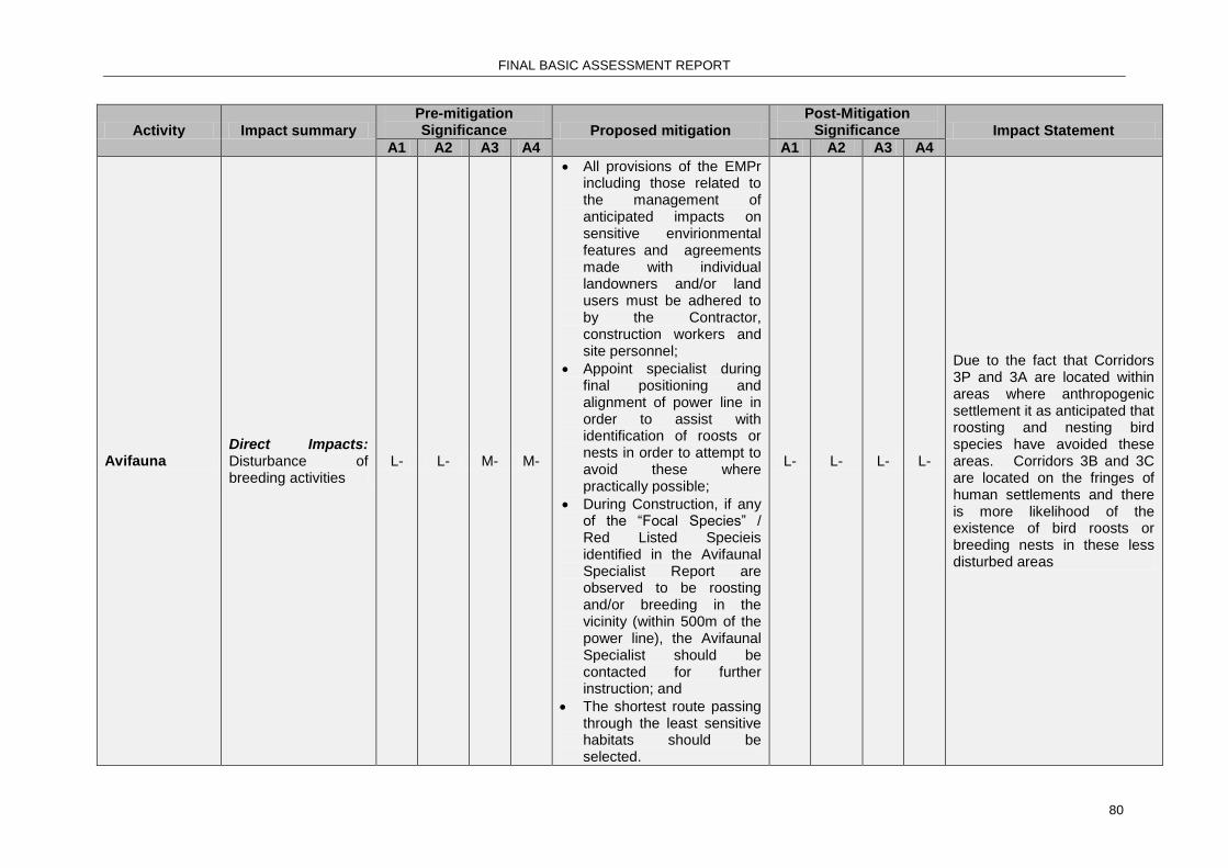
FINAL BASIC ASSESSMENT REPORT
80
Activity Impact summary
Pre-mitigation Significance Proposed mitigation
Post-Mitigation Significance Impact Statement
A1 A2 A3 A4 A1 A2 A3 A4
Avifauna Direct Impacts: Disturbance of breeding activities
L- L- M- M-
All provisions of the EMPr including those related to the management of anticipated impacts on sensitive envirionmental features and agreements made with individual landowners and/or land users must be adhered to by the Contractor, construction workers and site personnel;
Appoint specialist during final positioning and alignment of power line in order to assist with identification of roosts or nests in order to attempt to avoid these where practically possible;
During Construction, if any of the “Focal Species” / Red Listed Specieis identified in the Avifaunal Specialist Report are observed to be roosting and/or breeding in the vicinity (within 500m of the power line), the Avifaunal Specialist should be contacted for further instruction; and
The shortest route passing through the least sensitive habitats should be selected.
L- L- L- L-
Due to the fact that Corridors 3P and 3A are located within areas where anthropogenic settlement it as anticipated that roosting and nesting bird species have avoided these areas. Corridors 3B and 3C are located on the fringes of human settlements and there is more likelihood of the existence of bird roosts or breeding nests in these less disturbed areas

FINAL BASIC ASSESSMENT REPORT
81
Activity Impact summary
Pre-mitigation Significance Proposed mitigation
Post-Mitigation Significance Impact Statement
A1 A2 A3 A4 A1 A2 A3 A4
Avifauna
Direct impacts: Disturbance of birds, damage to nests or nesting grounds
H- H- H- H-
Identify areas where known nesting grounds are located and avoid taking access roads near these areas. Sensitise employees to issue;
Ensure that all construction activities remains in minimal working area;
Ensure that access roads clearly demarcated;
Vehicle movement should be confined to access roads; and
If any of the Red-listed species listedin the Avifauna Specialist Report are are observed to be roosting and / or breeding in the vicinity, the EWT must be contacted for further instruction.
H- H- H- H-
There will be some disturbance to bird life during construction but this can be reduced by implementing simple mitigation measures. Corridors 3B and 3C are characterised by undisturbed indigenous forest areas and thus are at risk of potential disturbance of breeding bird species.
Avifauna Direct Impacts: Avifauna habitat destruction
H- H- H- H-
Strict control should be maintained over all activities during construction, in particular heavy machinery and vehicle movements, and staff. Use existing access tracks where possible;
The removal of vegetation from the required working area within the servitude, should be done in accordance with Eskom’s
H- H- H- H-
Due to the fact that Corridors 3P and 3A are located within areas where anthropogenic settlement has already resulted on habitat destruction the expected impact of the construction activities is expected to be low. Corridors 3B and 3C are located on the fringes of human settlements and there is more likelihood of requiring a greater degree of removal of indigenous

FINAL BASIC ASSESSMENT REPORT
82
Activity Impact summary
Pre-mitigation Significance Proposed mitigation
Post-Mitigation Significance Impact Statement
A1 A2 A3 A4 A1 A2 A3 A4
Vegetation Management and Maintenance within Eskom Land, Servitudes and Rights of Way Standard (240- 70 0172585)
vegetation to create the cleared servitude and access routes.
Social and Socio-economic
Direct impacts: Damage to agricultural lands by construction activities.
L- L- L- L-
Negotiate access to agricultural lands with landowner. Sensitise employees to issue. Ensure all construction remains in agreed footprint area. Ensure access roads clearly marked and adhered to.
L- L- L- L-
Impact to agricultural lands will be low if mitigation measures implemented. There is very little agricultural land along any of the proposed corridors.
Direct Impacts: Disturbance of tourism activities
M- M- M- M- None required L- L- L-
The impact on tourism activities will be low due to proposed location of corridors away from prime tourism areas.
Cumulative impacts: Creation of temporary jobs during construction
L+ L+ L+ L+ Contractor to employ as many local labourers as is feasibly possible.
M+ M+ M+ M+
Construction phase will create temporary jobs for unskilled labour and drivers. This will result in a significant moderate positive impact in the area.
Vegetation
Direct impacts: Unnecessary loss of rare and endangered species due to bush clearing and access activities.
H- H- H- H-
Prior to the commencement of the Construction Phase an ECO should do a survey of the final route alignment to determine / identify specific sites along the route alignment where vegetation species of conservation importance
M- M- H- H-
If no controls are in place then there is a chance that some rare or endangered species will be damage during these activities. This risk is higher for Corridors 3B and 3C. the ratings remain high due to the sensitivity of the sand forest habitat.

FINAL BASIC ASSESSMENT REPORT
83
Activity Impact summary
Pre-mitigation Significance Proposed mitigation
Post-Mitigation Significance Impact Statement
A1 A2 A3 A4 A1 A2 A3 A4
(Red List and protected)are found;
• Prior to commencement of the Construction Phase, permits to remove all protected trees within the route alignment must be applied for and obtained from the relevant national and/or provincial authority; and
The relevant national/provincial authority must be consulted to determine any specific requirements which the authority may have and authorisations / permits required for the management of all species along the power line route which have been categorised by the IUCN Red List of Threatened Species as Near Threatened, Vulnerable, Endangered or Critically Endangered species
Direct impacts: Unnecessary loss of indigenous vegetation due to uncontrolled access activities.
H- H- H- H-
Ensure access routes are planned, clearly demarcated and suitable for the vehicles that will be using them. Ensure drivers are sensitised and
L- M- M- M-
Poor management of construction vehicle access can result in the development of multiple tracks on a servitude.

FINAL BASIC ASSESSMENT REPORT
84
Activity Impact summary
Pre-mitigation Significance Proposed mitigation
Post-Mitigation Significance Impact Statement
A1 A2 A3 A4 A1 A2 A3 A4
disciplined to the issue. Vehicle access through riparian or wetland system to be limited to pre-existing formal access only.
Vegetation clearing should be restricted to the minimum required working in area within the servitude and demarcated access tracks / roads;
Areas to be cleared should be clearly demarcated to prevent prevent unnecessary vegetation clearing outside the demarcated sites;
Removed topsoil should be stockpiled and used to rehabilitate disturbed areas.
It is recommended that an Environmental Control Officer (ECO) be consulted prior to the commencement of vegetation clearing to determine any additional suggested mitigation measures; and
It is recommended that the holder of the Environmental Authorisation monitor and manage rehabilitated areas during the defects period

FINAL BASIC ASSESSMENT REPORT
85
Activity Impact summary
Pre-mitigation Significance Proposed mitigation
Post-Mitigation Significance Impact Statement
A1 A2 A3 A4 A1 A2 A3 A4
(recommended period of 12 months) to ensure successful stabilisation and revegetation of the areas disturbed by construction.
Direct Impacts: Bush clearing through riparian and riverine vegetation may result in unnecessary loss of riparian and riverine vegetation.
H- H- H- H-
The removal of vegetation from the required working area within the servitude, should be done in accordance with Eskom’s Vegetation Management and Maintenance within Eskom Land, Servitudes and Rights of Way Standard (240- 70 0172585).
H- H- H- H-
Poor management of clearing the servitude through riparian and riverine vegetation can result in unnecessary damage to these sensitive environments

FINAL BASIC ASSESSMENT REPORT
86
Activity Impact summary
Pre-mitigation Significance Proposed mitigation
Post-Mitigation Significance Impact Statement
A1 A2 A3 A4 A1 A2 A3 A4
Vegetation
Direct Impacts: Control of invader species along servitude and access roads.
M+ M+ M+ M+
Ensure policies are strictly and consistently enforced through construction phase;
Forming part of vegetation management measures included in Eskom’s CNC EMP Standard (KZN13TGS014), monitoring inspections and subsequent exotic species control interventions should be conducted at least once a year during the growing/wet season for the first 3 years of the power-lines operations;
An exotic species control programme, including monitoring, must be developed and implemented to reduce the encroachment of exotic invasive species in the power-line corridor; and
It is recommended that monitoring inspections and subsequent exotic species control interventions should be conducted at least once a year during the growing/wet season for the first 3 years of the power-lines operations.
M+ M+ M+
The bush clearing and invader species management policies of Eskom encourage clearing and management of invader species in the entire project area - POSTIVE IMACT
Vegetation Indirect Impacts: H- H- H- H- An invader species M- M- M- M- The clearing of indigenous

FINAL BASIC ASSESSMENT REPORT
87
Activity Impact summary
Pre-mitigation Significance Proposed mitigation
Post-Mitigation Significance Impact Statement
A1 A2 A3 A4 A1 A2 A3 A4
Bush clearing along servitude and access routes may increase the risk of invader species encroachment.
eradication and management plan must be developed for the construction phase and must be implemented consistently throughout construction phase.
vegetation creates an opportunity for encroachment by invader species in to areas that are relatively pristine.
Vegetation
Indirect Impacts: Vegetation removal can increase erosion potential.
M- M- M- M-
Bush clearing may only occur through cutting or trimming. No scalping or ploughing of the earth is permitted.
L- L- L- L-
If the servitude, access routes and construction areas are denuded, there will be a significant increase in erosion
Soil
Indirect Impacts: Vegetation removal can result in the loss of topsoil.
M- M- M- M-
Bush clearing may only occur through cutting or trimming;
No scalping or ploughing is permitted; and
Removed topsoil should be stockpiled and used to rehabilitate disturbed areas.
L- L- L- L-
If the servitude, access routes and construction areas are denuded, there will be a significant increase in erosion and loss of topsoil
Soil
Indirect Impacts: Hardening of soil surfaces by construction activities can prevent the revegetation of an area and promote erosion.
M- M- M- M-
All hardened surfaces will be ripped during the rehabilitation phase to assist with rapid vegetation re-establishment.
L- L- L- L- Hardening of soil surfaces will prevent the re-establishment of vegetation.
Ecological
Indirect Impacts: Construction activities will cause fragmentation of habitats during construction.
M- M- M- M-
Must be limited by minimising clearance wherever possible; by ensuring good discipline of vehicle movements on site and staying on one track.
L- L- L- L-
Activities during construction will divide up the continuity of habitats and prevent natural movements.
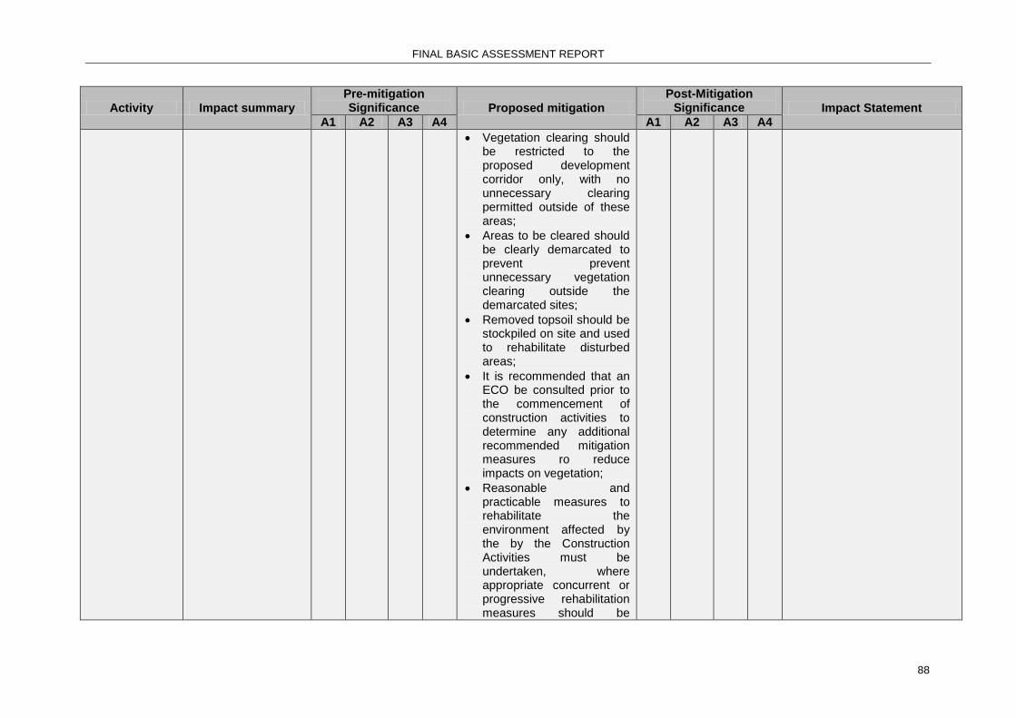
FINAL BASIC ASSESSMENT REPORT
88
Activity Impact summary
Pre-mitigation Significance Proposed mitigation
Post-Mitigation Significance Impact Statement
A1 A2 A3 A4 A1 A2 A3 A4
Vegetation clearing should be restricted to the proposed development corridor only, with no unnecessary clearing permitted outside of these areas;
Areas to be cleared should be clearly demarcated to prevent prevent unnecessary vegetation clearing outside the demarcated sites;
Removed topsoil should be stockpiled on site and used to rehabilitate disturbed areas;
It is recommended that an ECO be consulted prior to the commencement of construction activities to determine any additional recommended mitigation measures ro reduce impacts on vegetation;
Reasonable and practicable measures to rehabilitate the environment affected by the by the Construction Activities must be undertaken, where appropriate concurrent or progressive rehabilitation measures should be

FINAL BASIC ASSESSMENT REPORT
89
Activity Impact summary
Pre-mitigation Significance Proposed mitigation
Post-Mitigation Significance Impact Statement
A1 A2 A3 A4 A1 A2 A3 A4
implemented;
It is recommended that the holder of EA monitor and manage rehabilitated areas during the defects period (recommended 12 months) to ensure successful stabilisation and re-vegetation of the areas disturbed by construction;
Prior to the commencement of the Construction Phase an ECO should do a survey of the final route alignment to determine / identify specific sites along the route alignment where vegetation species of conservation importance (Near Threatened, Vulnerable, Endangered or Critically Endangered, Red List and protected)are found;
Prior to commencement of the Construction Phase, permits to remove all protected trees within the route alignment must be applied for and obtained from the relevant national and/or provincial authority; and
The relevant

FINAL BASIC ASSESSMENT REPORT
90
Activity Impact summary
Pre-mitigation Significance Proposed mitigation
Post-Mitigation Significance Impact Statement
A1 A2 A3 A4 A1 A2 A3 A4
national/provincial authority must be consulted to determine any specific requirements which the authority may have and authorisations / permits required for the management of all species along the power line route which have been categorised by the IUCN Red List of Threatened Species as Near Threatened, Vulnerable, Endangered or Critically Endangered species.
Surface water and wetlands
Direct Impacts: Bush clearing can result in increased stormwater run-off and soil erosion
M- M- M- M-
Bush clearing may only be achieved through cutting - no scalping will be permitted. Destumping of trees on stream and river banks will not be permitted.
Care must be taken to ensure that in removing vegetation adequate erosion prevention be implemented.
L- L- L- L-
Poor bush clearing practices can result in increased stormwater flow and soil erosion.
Noise
Direct Impacts: Operation of construction equipment and vehicles will increase noise levels
L- L- L-
Ensure all vehicles and equipment are in good working order and within allowable noise ranges. Equipment exceeding allowable must be equipped with silencers or removed from site. Operations should occur during
L- L- L- L- Noise levels will increase at the construction areas only.
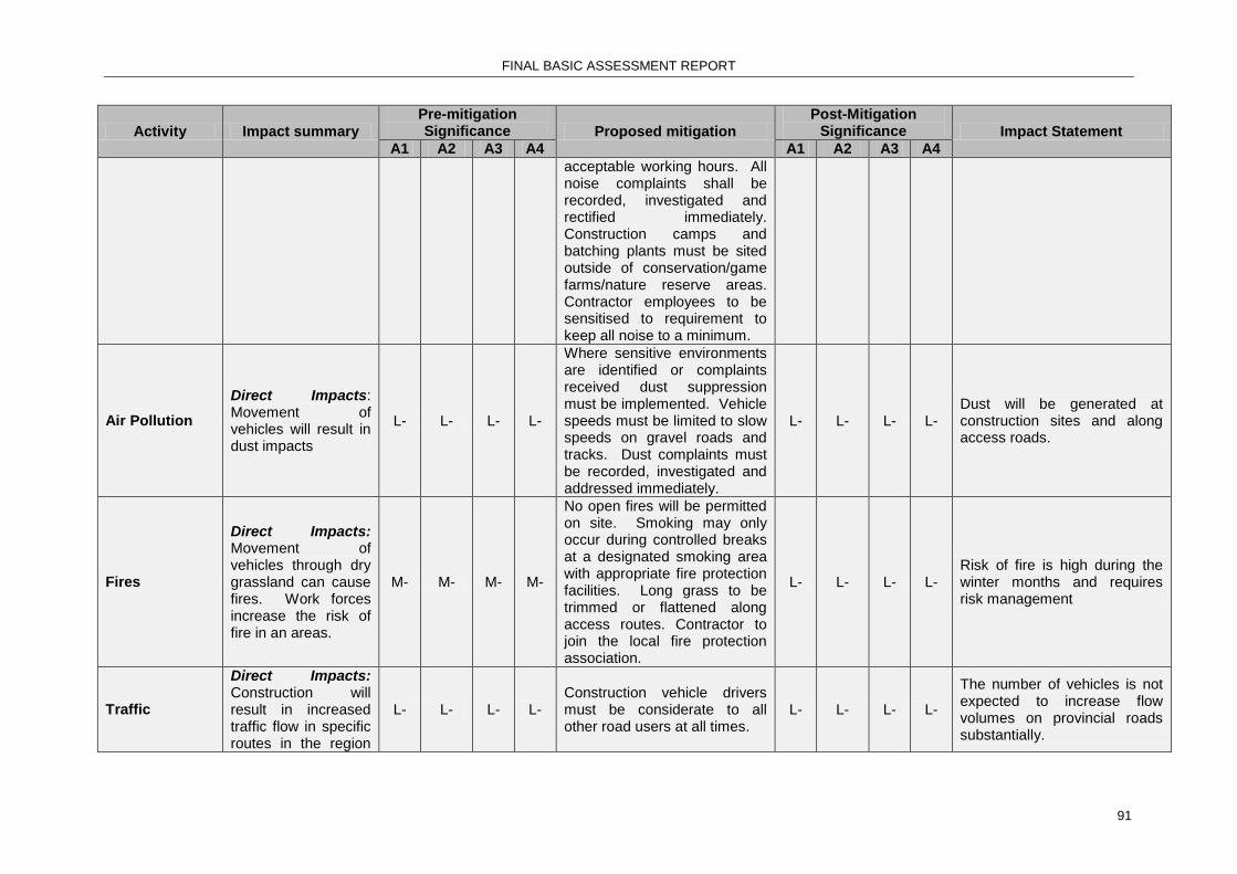
FINAL BASIC ASSESSMENT REPORT
91
Activity Impact summary
Pre-mitigation Significance Proposed mitigation
Post-Mitigation Significance Impact Statement
A1 A2 A3 A4 A1 A2 A3 A4
acceptable working hours. All noise complaints shall be recorded, investigated and rectified immediately. Construction camps and batching plants must be sited outside of conservation/game farms/nature reserve areas. Contractor employees to be sensitised to requirement to keep all noise to a minimum.
Air Pollution
Direct Impacts: Movement of vehicles will result in dust impacts
L- L- L- L-
Where sensitive environments are identified or complaints received dust suppression must be implemented. Vehicle speeds must be limited to slow speeds on gravel roads and tracks. Dust complaints must be recorded, investigated and addressed immediately.
L- L- L- L- Dust will be generated at construction sites and along access roads.
Fires
Direct Impacts: Movement of vehicles through dry grassland can cause fires. Work forces increase the risk of fire in an areas.
M- M- M- M-
No open fires will be permitted on site. Smoking may only occur during controlled breaks at a designated smoking area with appropriate fire protection facilities. Long grass to be trimmed or flattened along access routes. Contractor to join the local fire protection association.
L- L- L- L- Risk of fire is high during the winter months and requires risk management
Traffic
Direct Impacts: Construction will result in increased traffic flow in specific routes in the region
L- L- L- L- Construction vehicle drivers must be considerate to all other road users at all times.
L- L- L- L-
The number of vehicles is not expected to increase flow volumes on provincial roads substantially.
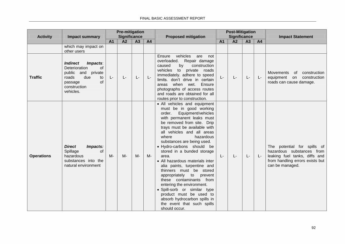
FINAL BASIC ASSESSMENT REPORT
92
Activity Impact summary
Pre-mitigation Significance Proposed mitigation
Post-Mitigation Significance Impact Statement
A1 A2 A3 A4 A1 A2 A3 A4
which may impact on other users
Traffic
Indirect Impacts: Deterioration of public and private roads due to passage of construction vehicles.
L- L- L- L-
Ensure vehicles are not overloaded. Repair damage caused by construction vehicles to private roads immediately. adhere to speed limits. don’t drive in certain areas when wet. Ensure photographs of access routes and roads are obtained for all routes prior to construction.
L- L- L- L- Movements of construction equipment on construction roads can cause damage.
Operations
Direct Impacts: Spillage of hazardous substances into the natural environment
M- M- M- M-
All vehicles and equipment must be in good working order. Equipment/vehicles with permanent leaks must be removed from site. Drip trays must be available with all vehicles and all areas where hazardous substances are being used.
Hydro-carbons should be stored in a bunded storage area.
All hazardous materials inter alia paints, turpentine and thinners must be stored appropriately to prevent these contaminants from entering the environment.
Spill-sorb or similar type product must be used to absorb hydrocarbon spills in the event that such spills should occur.
L- L- L- L-
The potential for spills of hazardous substances from leaking fuel tanks, diffs and from handling errors exists but can be managed.

FINAL BASIC ASSESSMENT REPORT
93
Activity Impact summary
Pre-mitigation Significance Proposed mitigation
Post-Mitigation Significance Impact Statement
A1 A2 A3 A4 A1 A2 A3 A4
Operations
Direct Impacts: Poor waste management can cause environmental damage
L- L- L- L-
An integrated waste management plan must be compiled during site establishment and must be implemented continuously throughout the construction phase.
Demarcated areas where waste can be safely contained and stored on a temporary basis during the construction phase should be provided at the hard park.
When adequate volumes (not more than 1 month) have accumulated all waste is to be removed from site and disposed of at a licensed facility.
Waste is not to be buried on site.
Hydro-carbons should be stored in a bunded storage area;
All hazardous materials inter alia paints, turpentine and thinners must be stored appropriately to prevent these contaminants from entering the environment; and
Spill-sorb or similar type product must be used to absorb hydrocarbon spills in the event that such spills
L- L- L- L- Poor waste management can lead to soil, water and air pollution.

FINAL BASIC ASSESSMENT REPORT
94
Activity Impact summary
Pre-mitigation Significance Proposed mitigation
Post-Mitigation Significance Impact Statement
A1 A2 A3 A4 A1 A2 A3 A4
should occur.
Economic Development
Cumulative Impacts: Strengthening of the grid will ensure uninterrupted electricity supply in Northern Zululand.
H+ H+ H+ H=
The new 132kV power line must be constructed to achieve this result in the region and to ensure the success and efficiency of all the other grid strengthening activities that are being planned in the region.
H+ H+ H+ H+
Construction phase will create temporary jobs for unskilled labour and drivers. This will result in a significant moderate positive impact in the area.
OPERATIONAL PHASE
Activity Impact summary
Pre-mitigation Significance Proposed mitigation
Post-Mitigation Significance Impact Statement
A1 A2 A3 A4 A1 A2 A3 A4
Fires
Direct impacts: Ignition of veld due to conductor failure or flash overs.
M- M- M- M- Regular line inspections to
ensure the integrity of the line.
M- M- M- M-
Fires do occur on occasion as a result of conductor failure. However, design has been optimised to prevent such events wherever possible
Avifauna
Direct impacts: Electrocution of avifauna and collisions with the conductor.
H- H- H- H-
Ensure that all these bird diversion structures remain in working order at all times. Bird diverter and bird guard placement may improve the electrocution and collision percentage. Using a tower design other than the standard delta tower may also reduce avifaunal impacts.
L- L- L- L-
This impact will be low during operation due to the placement of bird diverters to increase the visibility of the conductor. The tower structure to be used reduces the probability of bird electrocutions and bird guards will be implemented where required.

FINAL BASIC ASSESSMENT REPORT
95
Activity Impact summary
Pre-mitigation Significance Proposed mitigation
Post-Mitigation Significance Impact Statement
A1 A2 A3 A4 A1 A2 A3 A4
Servitude Maintenance
Direct Impacts: Overgrown servitude and associated electrical clearance problems
M- M- M- M+
Eskom to ensure that the vegetation clearance and line maintenance occurs as per Eskom Policies;
The width of the power-line corridor where vegetation is actively maintained during the operational phase must be kept at an absolute minimum that permits safe operation of the power line, as per Eskom’s Vegetation Management and Maintenance within Eskom Land, Servitudes and Rights of Way Standard (240-70172585); and
Ensure that as much natural vegetation as possible is retained within the corridor once the servitude is cleared to ensure visual screening.
L- L- L- L-
This impact has been rated moderate due to the number of issues raised by landowners in the area relating to poor servitude maintenance.
Access Tracks
Direct Impacts: Poor maintenance of access tracks results in erosion of these tracks.
M- M- M- M- Institute erosion prevention
measures. L- L- L- L-
This impact has been rated moderate due experience of other eskom lines where maintenance of the access tracks is non-existent and significant erosion features have developed

FINAL BASIC ASSESSMENT REPORT
96
Activity Impact summary
Pre-mitigation Significance Proposed mitigation
Post-Mitigation Significance Impact Statement
A1 A2 A3 A4 A1 A2 A3 A4
Servitude Maintenance
Indirect Impacts: Poor management on Eskom servitude gates exposes landowners to illegal trespassers and provides access to criminals and creates a poaching risk.
M- M- M- M-
Eskom to ensure that the access maintenance servitude gates and locks occurs as per Eskom Policies. Suggest cooperating with landowner to maintain security.
L- L- L- L-
This impact has been rated moderate due experience of other eskom lines where lock management on servitude gates has assisted criminal access to private land.
Provision of electricity
Indirect Impacts: Faulting causing Loss of stable electricity supply i.e. outages which impacts negatively on businesses hospitals, schools etc.
L- L- L- L-
The implementation of the proposed project will contribute to ensuring a stable supply of electricity in the Makhathini Flats area.
L- L- L- L-
This impact has been rated Low as the commissioning of this proposed power line will reduce the risk of faulting and power outages in the region
Economic Development
Cumulative Impacts: Strengthening of the grid will ensure uninterrupted electricity supply in Northern Zululand
H+ H+ H+ H+ No mitigation required.
Strengthening of the will assist with improving economic development in the region, alleviating poverty and assist with provision of basic services to all - HIGH POSITIVE IMPACT

FINAL BASIC ASSESSMENT REPORT
97
NO GO OPTION Activity Impact summary Pre-mitigation
Significance Proposed mitigation Post-Mitigation
Significance
A1 A2 A3 A4 A1 A2 A3 A4
Biophysical Environment
Direct impacts: Environment remains in the current status quo.
L+ L+ L+ L+ No mitigation required.
Socio-Economic Environment
Indirect impacts: The current unreliable supply of electricity in the region and the lack of capacity to supply planned economic growth and delivery of basic services will negatively impact the socio-economic growth of the region resulting in failure of the Provincial, District and Local Municipalities to achieve the stated IDP targets and objectives.
H- H- H- H- Construct and energise the proposed 132kV
power line between the Ndumo and Gezisa substations.
H+ H+ H+ H+
The complete impact assessment methodology and ranking tables are presented in Appendix F.
A complete impact assessment in terms of Regulation 22(2)(i) of GN R.543 must be included as Appendix F.
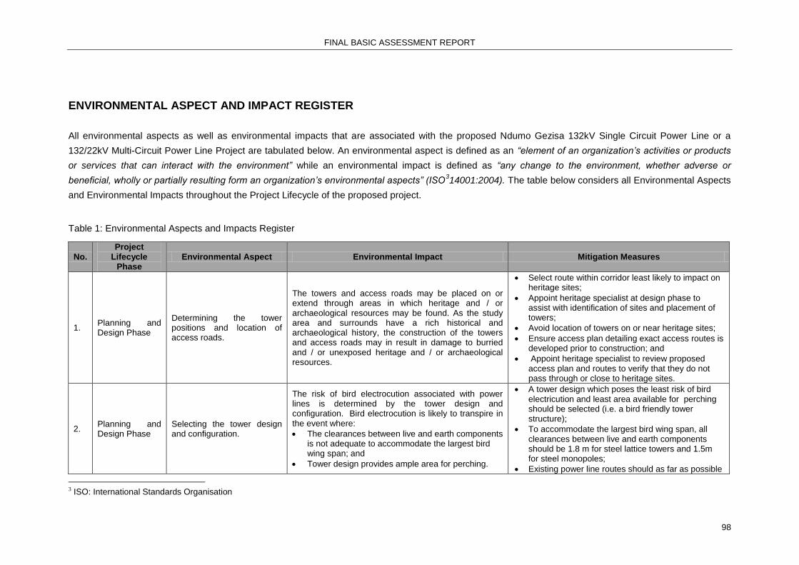
FINAL BASIC ASSESSMENT REPORT
98
ENVIRONMENTAL ASPECT AND IMPACT REGISTER
All environmental aspects as well as environmental impacts that are associated with the proposed Ndumo Gezisa 132kV Single Circuit Power Line or a
132/22kV Multi-Circuit Power Line Project are tabulated below. An environmental aspect is defined as an “element of an organization’s activities or products
or services that can interact with the environment” while an environmental impact is defined as “any change to the environment, whether adverse or
beneficial, wholly or partially resulting form an organization’s environmental aspects” (ISO314001:2004). The table below considers all Environmental Aspects
and Environmental Impacts throughout the Project Lifecycle of the proposed project.
Table 1: Environmental Aspects and Impacts Register
No. Project
Lifecycle Phase
Environmental Aspect Environmental Impact Mitigation Measures
1. Planning and Design Phase
Determining the tower positions and location of access roads.
The towers and access roads may be placed on or extend through areas in which heritage and / or archaeological resources may be found. As the study area and surrounds have a rich historical and archaeological history, the construction of the towers and access roads may in result in damage to burried and / or unexposed heritage and / or archaeological resources.
Select route within corridor least likely to impact on heritage sites;
Appoint heritage specialist at design phase to assist with identification of sites and placement of towers;
Avoid location of towers on or near heritage sites;
Ensure access plan detailing exact access routes is developed prior to construction; and
Appoint heritage specialist to review proposed access plan and routes to verify that they do not pass through or close to heritage sites.
2. Planning and Design Phase
Selecting the tower design and configuration.
The risk of bird electrocution associated with power lines is determined by the tower design and configuration. Bird electrocution is likely to transpire in the event where:
The clearances between live and earth components is not adequate to accommodate the largest bird wing span; and
Tower design provides ample area for perching.
A tower design which poses the least risk of bird electricution and least area available for perching should be selected (i.e. a bird friendly tower structure);
To accommodate the largest bird wing span, all clearances between live and earth components should be 1.8 m for steel lattice towers and 1.5m for steel monopoles;
Existing power line routes should as far as possible
3 ISO: International Standards Organisation

FINAL BASIC ASSESSMENT REPORT
99
No. Project
Lifecycle Phase
Environmental Aspect Environmental Impact Mitigation Measures
be followed to increase visibility of the power line structure;
Ensure that suitable bird repelling structure, such as bird guards are considered in the design; and
The further design option of a steel lattice tower with horizontal configuration as opposed to a delta configuration is the most preferable. This tower type may be construed as being more visually intrusive as the cross-arm is longer and its use will be more costly than the delta configuration.
A summary of bird electrocution risk associated with a 132kV Multi-circuit Power Line and a 132kV Single Cicruit Power Line is provided in Section 10: Activity Motivation (page 25) of the Amended Final Basic Assessment Report.
3. Planning and Design Phase
Determining feasible alternative power line route corridors.
The legnth of the various possible route corridors may differ and therefore also determine the extent of the area to be cleared. The clearing of vegetation along the power line route within the corridor will result in a loss of habitat as well as disturbance of breeding activities.
Select corridor requiring the least amount of clearing of indigenous bush for access construction and maintenance; and
Vegetation clearing should be: o Limited to 16m within the working area; and o Vegeation should only be removed from the
minimum required construction and / or working area, within the servitude.
4. Planning and Design Phase
Determining feasible alternative power line route corridors.
The visibility of the power line may give rise to a visual disturbance on tourism route / operations and residential homes.
Select Corridor with least potential to impact on breeding activities of endemic birds; and
Appoint specialist during final positioning and alignment of power line in order to assist with identification of roosts or nests in order to attempt to avoid these where practically possible.
5. Planning and Design Phase
Determining feasible alternative power line route corridors.
All indigenous vegetation as well as endangered / protected species within the selected corridor and constrution footprint will be cleared thereby resulting in:
Loss of species of conservation importance;
Habitat loss and degradation; and
Habitat fragmentation.
Select corridor and route least likely to impact on indigenous vegetation. Where possible locate towers and alignment in areas of least dense indigenous vegetation and tree cover to minimise the amount of bush clearing required;
Select corridor and route least likely to impact on terrestrial fauna. Where possible locate towers and focus alignment in areas where habitat transformation has already occurred.

FINAL BASIC ASSESSMENT REPORT
100
No. Project
Lifecycle Phase
Environmental Aspect Environmental Impact Mitigation Measures
All efforts should be made to select a route which requires the least clearing of species forming part of the vegetation community, where the loss of vegetation havs been rated as a high significance impact (e.g. Sand Forest) (refer to Appendix D1); and
A specialist botanist should be appointed during the design phase to assist with the final alignment of the power line in the approved corridor to minimise or avoid placement of the power-line through sensitive vegetation (such as Sand Forest) where possible.
6. Planning and Design Phase
Selected alternative power line route corridors may extend through or within close proximity to the extent of the riparian area.
Placing the towers within the riparian area will alter the characteristics of the associated watercourses.
No other structures, apart from a single elongated platform within the the floodplain on the North-Western side of the Makhanye’s Drift, may be constructed within the 1:100 year floodline;
The design of the towers must take cogniscance of the impact of Pongola River flow on the power line and ensure that the structure can withstand the velocity and volume of flow;
Use existing river crossings where possible;
The working area within riparian areas should be confinedto the smallest possible footprint;
Select power line route alignment with least potential to impact on riverine vegetation;
Avoid impacts to wetlands and perennial rivers as far as possible;
Select corridor traversing wetlands in those areas where the wetlands have already been subjected to a high level of anthropogenic transformation or degradation. Use findings of specialist study to select power line route alignment within corridor with least potential to impact on water sources and to assist in placement of the towers to, as far as possible, avoid these features;
No-go areas should be clearly demarcated for the duration of the Construction Phase. No activities or movement within the no-go areas will be permitted;
The DWS should be consulted to determine any

FINAL BASIC ASSESSMENT REPORT
101
No. Project
Lifecycle Phase
Environmental Aspect Environmental Impact Mitigation Measures
specific requirements regarding undertaking construction activities within the extent of watercourses and floodplains during controlled events;
Regular inspection of all activities which are carried out within close proximity to watercourses, must be done by a ECO; and
All reasonable measures should be taken to prevent adverse impacts on all watercourses which are associated with the proposed project.
7. Planning and Design Phase
Conducting the Basic Assessment Process for the proposed project as part of the Environmental Authorisation Process.
Strengthening of the grid will ensure uninterrupted electricity supply in Northern Zululand.
The new 132kV power line must be constructed to achieve this result in the region and to ensure the success and efficiency of all the other grid strengthening activities that are being planned in the region.
8. Planning and Design Phase
Determining feasible alternative power line route corridors.
Residences and buildings which fall within the authorised / selected corridor will have to be demolished to accommodate the pipeline. The demolishment of the aforementioned buildings and residences will neccesitate land owners negotiations as well as the relocation of the affected parties.
Select corridor least likely to require the movement of homes to create space for the construction and operation of a power line.
9. Planning and Design Phase
Determining feasible alternative power line route corridors.
Introduction of a non-compatible land use into an area due to inappropriate alignment of the power line.
Select corridor and route least likely to introduce new incompatible land use into new areas.
10. Construction Phase
Excavation of the pylon foundations.
Excavations during the Construction Phase may damage underlying or unexposed heritage and Paleontological resources.
Ensure all identified sites are clearly demarcated prior to construction and that all persons on site are sensitised to the issue and the significance;
Stop work if new site exposed during construction; and
Notify provincial heritage authority.
11. Construction Phase
The movement of construction vehicles and construction activities may disrupt breeding activities and alter the specific conditions for breeding within the area.
Disturbance of breeding activities of local birds.
All provisions of the EMPr including those related to the management of anticipated impacts on sensitive envirionmental features and agreements made with individual landowners and/or land users must be adhered to by the Contractor, construction workers and site personnel;
Appoint specialist during final positioning and alignment of power line in order to assist with identification of roosts or nests in order to attempt

FINAL BASIC ASSESSMENT REPORT
102
No. Project
Lifecycle Phase
Environmental Aspect Environmental Impact Mitigation Measures
to avoid these where practically possible;
During Construction, if any of the “Focal Species” / Red Listed Species identified in the Avifaunal Specialist Report are observed to be roosting and/or breeding in the vicinity (within 500m of the power line), the Avifaunal Specialist should be contacted for further instruction;
The shortest route passing through the least sensitive habitats should be selected;
Strict control should be maintained over all activities during construction and maintenance, in particular heavy machinery and vehicle movements, and staff.
12. Construction Phase
Vegetation clearing within the construction footprint and within the boundries of the access roads.
Habitat degradation for terrestrial fauna as well as avifauna.
Strict control should be maintained over all activities during construction, in particular heavy machinery and vehicle movements, and staff. Use existing access tracks where possible; and
The removal of vegetation from the required working area within the servitude, should be done in accordance with Eskom’s Vegetation Management and Maintenance within Eskom Land, Servitudes and Rights of Way Standard (240- 70 0172585).
13. Construction Phase
The movement of construction vehicles and workers as well as the construction activities within nesting areas.
Disturbance of birds, damage to nests or nesting grounds.
Identify areas where known nesting grounds are located and avoid taking access roads near these areas. Sensitise employees to issue;
Ensure that all construction activities remain in minimal working footprint (16m wide);
Ensure that access roads clearly demarcated;
Vehicle movement should be confined to access roads as far as possible; and
If any of the Red-listed species listedin the Avifauna Specialist Report are are observed to be roosting and / or breeding in the vicinity, the EWT must be contacted for further instruction.
14. Construction Phase
Construction of towers within croplands.
Vegetation clearing surrounding towers will result in the loss of crops within the construction footprint.
Negotiate access to agricultural lands with landowner. Sensitise employees to issue;
Ensure all construction remains in agreed footprint area; and

FINAL BASIC ASSESSMENT REPORT
103
No. Project
Lifecycle Phase
Environmental Aspect Environmental Impact Mitigation Measures
Ensure access roads clearly marked and adhered to.
15. Construction Phase
Employment of local labour for duration of Construction Phase.
Creation of temporary jobs during construction. Contractor to employ as many local labourers as is feasibly possible.
16. Construction Phase
Clearing of all vegetation within the construction footprint.
Loss of rare and endangered species due to bush clearing and access activities.
Prior to the commencement of the Construction Phase an ECO should do a survey of the final route alignment to determine / identify specific sites along the route alignment where vegetation species of conservation importance (Red List and protected) are found;
Prior to commencement of the Construction Phase, permits to remove all protected species within the route alignment must be applied for and obtained from the relevant national and/or provincial authority; and
The relevant national/provincial authority must be consulted to determine any specific requirements which the authority may have and authorisations / permits required for the management of all species along the power line route which have been categorised by the IUCN Red List of Threatened Species as Near Threatened, Vulnerable, Endangered or Critically Endangered species.

FINAL BASIC ASSESSMENT REPORT
104
No. Project
Lifecycle Phase
Environmental Aspect Environmental Impact Mitigation Measures
17. Construction Phase
Clearing of all vegetation within the construction footprint including riparian areas.
Loss of indigenous vegetation due to uncontrolled access activities.
Ensure access routes are planned, clearly demarcated and suitable for the vehicles that will be using them. Ensure drivers are sensitised and disciplined to the issue. Vehicle access through riparian or wetland system to be limited to pre-existing formal access only.
Vegetation clearing should be restricted to the minimum required working area (16m) within the servitude and demarcated access tracks / roads;
Areas to be cleared should be clearly demarcated to prevent unnecessary vegetation clearing outside the demarcated sites;
Removed topsoil should be stockpiled and used to rehabilitate disturbed areas;
It is recommended that an Environmental Control Officer be consulted prior to the commencement of vegetation clearing to determine any additional suggested mitigation measures; and
It is recommended that the holder of the Environmental Authorisation monitor and manage rehabilitated areas during the defects period (recommended period of 12 months) to ensure successful stabilisation and re-vegetation of the areas disturbed by construction.
18. Construction Phase
Clearing of natural vegetation may create conditions conducive to the establishment and colonisation of exotic and/or declared CARA Category 1, 2 and Category 3 invader plants.
Establishment of exotic and / or declared Category 1, 2 and Category 3 invader species.
An exotic species control programme, including monitoring, must be developed and implemented to reduce the encroachment of exotic invasive species in the power line corridor; and
It is recommended that monitoring inspections and subsequent exotic species control interventions should be conducted at least once a year during the growing/wet season for the first 3 years of the power lines operations.
19. Construction Phase
Clearing of all vegetation within the construction footprint.
The bare ground will be prone to erosion as a result of the vegetation clearing.Increased velocity of runoff across bare soil surface may result in soil erosion.
Bush clearing may only occur through cutting or trimming;
No scalping or ploughing of the earth is permitted;
Destumping of trees on stream and river banks will not be permitted; and
Care must be taken to ensure that if removing

FINAL BASIC ASSESSMENT REPORT
105
No. Project
Lifecycle Phase
Environmental Aspect Environmental Impact Mitigation Measures
vegetation adequate erosion prevention be implemented.
20. Construction Phase
Removal of topsoil within construction footrpint during excavations.
Vegetation removal can result in the loss of topsoil.
Bush clearing may only occur through cutting or trimming;
No scalping or ploughing is permitted; and
Removed topsoil should be stockpiled and used to rehabilitate disturbed areas.
21. Construction Phase
Movement of construction vehicles across cleared areas.
Hardening and compaction of soil can prevent the revegetation of an area and promote erosion.
All hardened surfaces will be ripped during the rehabilitation phase to assist with rapid vegetation re-establishment.
22. Construction Phase
Removal of vegetation within the construction footprint.
Construction activities will cause fragmentation of habitats during construction.
Habitat fragmentaiton can be limited by minimising clearance wherever possible; by ensuring good discipline of vehicle movements on site and staying on one track;
Vegetation clearing should be restricted to the proposed development corridor only, with no unnecessary clearing permitted outside of these areas;
Areas to be cleared should be clearly demarcated to prevent unnecessary vegetation clearing outside the demarcated sites;
Removed topsoil should be stockpiled on site and used to rehabilitate disturbed areas;
It is recommended that an ECO be consulted prior to the commencement of construction activities to determine any additional recommended mitigation measures ro reduce impacts on vegetation;
Reasonable and practicable measures to rehabilitate the environment affected by the Construction Activities must be undertaken, where appropriate concurrent or progressive rehabilitation measures should be implemented;
It is recommended that the holder of EA monitor and manage rehabilitated areas during the defects period (recommended 12 months) to ensure successful stabilisation and re-vegetation of the areas disturbed by construction;
Prior to the commencement of the Construction Phase an ECO should do a survey of the final route

FINAL BASIC ASSESSMENT REPORT
106
No. Project
Lifecycle Phase
Environmental Aspect Environmental Impact Mitigation Measures
alignment to determine / identify specific sites along the route alignment where vegetation species of conservation importance (Near Threatened, Vulnerable, Endangered or Critically Endangered, Red List and protected) are found;
Prior to commencement of the Construction Phase, permits to remove all protected trees within the route alignment must be applied for and obtained from the relevant national and/or provincial authority; and
The relevant national/provincial authority must be consulted to determine any specific requirements which the authority may have and authorisations / permits required for the management of all species along the power line route which have been categorised by the IUCN Red List of Threatened Species as Near Threatened, Vulnerable, Endangered or Critically Endangered species.
23. Construction Phase
The operation of equipment and implementation of construction activities which generate noise.
Increased ambient noise levels.
Ensure all vehicles and equipment are in good working order and within allowable noise ranges. Equipment exceeding allowable noise ranges must be equipped with silencers or removed from site; and
Operations should occur during acceptable working hours. All noise complaints shall be recorded, investigated and rectified immediately. Construction camps and batching plants must be sited outside of conservation/game farms/nature reserve areas. Contractor employees to be sensitised to requirement to keep all noise to a minimum.
24. Construction Phase
Vehicle and construction equipment activity.
Exhaust emmisions from construction vehicles and equipment as well as the dust generated by the movement of vehicles across bare soil surfaces thereby adversely impacting on the ambient air quality.
Where sensitive environments are identified or complaints received, dust suppression must be implemented;
Vehicle speeds must be limited to slow speeds (less than 30km/h) on gravel roads and track; and
Dust complaints must be recorded, investigated and addressed immediately.
25. Construction Phase
Movement of vehicles through dry grassland and
Damage to receiving environment (e.g. loss of vegetation, injury to fauna) caused by fires.
No open fires will be permitted on site;
Smoking may only occur during controlled breaks

FINAL BASIC ASSESSMENT REPORT
107
No. Project
Lifecycle Phase
Environmental Aspect Environmental Impact Mitigation Measures
workers starting open uncontrolled fires.
at a designated smoking area with appropriate fire protection facilities;
Long grass to be trimmed or flattened along access routes;
Contractor to join the local fire protection association; and
Suitable fire control measures must be implemented (e.g. easy access to suitable fire extinguishers, water bowsers).
26. Construction Phase
Movement of construction vehicles to and from the Site Camp and construction area.
Construction will result in increased traffic flow in specific routes in the region which may impact on other users.
Construction vehicle drivers must be considerate to all other road users at all times.
27. Construction Phase
Storage and use of hazardous substances.
Spillage of hazardous substances into the natural environment
All vehicles and equipment must be in good working order. Equipment/vehicles with permanent leaks must be removed from site. Drip trays must be available with all vehicles and all areas where hazardous substances are being used;
Hydro-carbons should be stored in a bunded storage area;
All hazardous materials inter alia paints, turpentine and thinners must be stored appropriately to prevent these contaminants from entering the environment; and
Spill-sorb or similar type product must be used to absorb hydrocarbon spills in the event that such spills should occur.
28. Construction Phase
Poor waste management. Pollution of receiving environment.
An integrated waste management plan must be compiled during site establishment and must be implemented continuously throughout the construction phase;
Demarcated areas where waste can be safely contained and stored on a temporary basis during the construction phase should be provided at the hard park;
When adequate volumes (not more than 1 month) have accumulated all waste is to be removed from site and disposed of at a licensed facility;
Waste may not to be buried on site;
Hydro-carbons should be stored in a bunded

FINAL BASIC ASSESSMENT REPORT
108
No. Project
Lifecycle Phase
Environmental Aspect Environmental Impact Mitigation Measures
storage area;
All hazardous materials inter alia paints, turpentine and thinners must be stored appropriately to prevent these contaminants from entering the environment; and
Spill-sorb or similar type product must be used to absorb hydrocarbon spills in the event that such spills should occur.
29. Operational Phase
Conductor failure or flash overs caused by bird streamers and / or lightning strikes.
Ignition of veld fires resulting from conductor failure, flash overs, lightning strikes and bird streamers.
Regular line inspections to ensure the integrity of the line.
30. Operational Phase
Avifauna collisions with power lines.
Electrocution of avifauna.
Ensure that all bird diversion structures recommended by the specialist remain in working order at all times; and
Bird diverter and bird guard placement may improve the electrocution and collision percentage;
Use an alternative tower configuration with proven reduced risk of bird electrocution, or
Amend the design of the delta configuration to allow for a greater distance between conductors and therefore reduced risk of electrocution; and/or
Will include bird diversion mitigation to the selected tower configuration to discourage roosting on the towers.
31. Operational Phase
Overgrown servitude. Overgrown vegetation within the servitude area directly below the power line may cause interference with overhead power line and pose a fire hazard.
Eskom to ensure that the vegetation clearance and line maintenance occurs as per Eskom Policies;
The width of the power-line corridor where vegetation is actively maintained during the operational phase must be kept at an absolute minimum that permits safe operation of the power line, as per Eskom’s Vegetation Management and Maintenance within Eskom Land, Servitudes and Rights of Way Standard (240-70172585); and
Ensure that as much natural vegetation as possible is retained within the corridor once the servitude is cleared to ensure visual screening.
32. Operational Phase
Poor maintenance of access tracks.
Erosion along access tracks. Movement of vehicles must be confined to
established access tracks; and

FINAL BASIC ASSESSMENT REPORT
109
No. Project
Lifecycle Phase
Environmental Aspect Environmental Impact Mitigation Measures
Suitable erosion management measures as per Eskom’s maintenance programme should be implemented.
33. Operational Phase
Poor management on Eskom servitude gates.
Increased accesibility of servitude to illegal trespassers and criminals.
Eskom to ensure that the access maintenance occurs as per Eskom Policies.
34. Operational Phase
Electricial faulting. Loss of stable electricity supply i.e. outages which impact negatively on businesses hospitals, schools etc.
The implementation of the proposed project will contribute to ensuring a stable supply of electricity in the Makhathini Flats area.

FINAL BASIC ASSESSMENT REPORT
110
2. ENVIRONMENTAL IMPACT STATEMENT
Taking the assessment of potential impacts into account, please provide an environmental
impact statement that summarises the impact that the proposed activity and its alternatives may
have on the environment after the management and mitigation of impacts have been taken into
account, with specific reference to types of impact, duration of impacts, likelihood of potential
impacts actually occurring and the significance of impacts.
Based on consideration of the specialist assessment reports of the preferred and alternative route
options and the assessment of all identified impacts as presented in the Impact Assessment section of
this report, the critical impacts of the preferred and alternative corridors are summarised in the
following table:
Impact Assessment Summary Table
Impact Type
Significance Points and Impact Ranking After Mitigation Description
A1 A2 A3 A4
Heritage Impacts
14 LOW
14 LOW
14 LOW
14 LOW
The potential impact to heritage sites is the same along all three corridors and can readily be mitigated by careful sighting of the towers with the assistance of a heritage specialist.
Avifauna Impacts
72 HIGH
72 HIGH
34 MODERATE
34 MODERATE
The development of the power line along Corridors 3P and 3A has a potentially lower impact to bird life due to the fact that these corridors traverse in close proximity to an existing overhead 22kV power line as well as being located primarily in the already disturbed ribbon development zone adjacent to provincial road P522.

FINAL BASIC ASSESSMENT REPORT
111
Social and Socio-economic Impacts
23 LOW
23 LOW
17 LOW
17 LOW
The development of the power line along the any of the 4 alternative corridors may have a low impact to social and socio-economic activities because the overhead and ground level impacts already exist in the area and the receiving environments are currently assimilating the negative impact. However, Corridors 3P and 3A are located closer to residential properties and therefore have a higher negative impact that the other alternatives
Vegetation Impacts
56 MODERATE
56 MODERATE
56 MODERATE
56 MODERATE
A total of 24 km each of natural bush will be required to be cleared along the Corridor 3P and 3A while Corridors 3B and 3C will require 38 km and 31 km respectively of natural bush. Species diversity is expected to be higher along the Corridors 3B and 3C due to presence of undisturbed patches of critically endangered Sand Forest located in these corridor alignments. Remnant patches of Sand Forest do occur in Corridors 3P and 3A but these patches have been impacted on anthropogenic activity.
Wetland 70 70 56 56 The potential for the

FINAL BASIC ASSESSMENT REPORT
112
Impacts HIGH HIGH MODERATE MODERATE establishment of a power line to impact negatively on surface water resources along all four corridors is considered low.
Visual Impacts
30 LOW
30 LOW
24 LOW
24 LOW
The potential for the establishment of a power line to impact negatively on visual outlooks is considered Low for all 4 corridors. Corridors 3P and 3A score slightly higher due to their proximity to and visibility from provincial road P522 which is considered a tourist route. Most biophysical impacts compound one another, however in the case of visual impact, often stakeholders prefer to have impacts in areas of existing impact. In the case of Corridors 3P and 3A the visual impact along an arterial road already paralleled by a 22kV overhead power line is expected. Setting the proposed 22/132kV multi-circuit power line a little back from the road i.e. Corridor 3P alignment will make the impact less intrusive and will not significantly increase the visibility rating above what currently exists.
Ecological Impacts
57 HIGH
57 HIGH
57 HIGH
57 HIGH
The potential impact on ecology is relatively low for Corridors 3P and 3A due to the location traversing primarily

FINAL BASIC ASSESSMENT REPORT
113
transformed land within the ribbon development zone that parallels road P522. The potential ecological impacts for Corridors 3B and 3C are high due to the requirement for clearance of relatively undisturbed vegetation, which includes the critically endangered Sand Forest.
Landuse Impacts
22 LOW
43 MODERATE
41 MODERATE
41 MODERATE
Corridor 3P is the preferred corridor when it comes to landuse impacts as the natural ecology has been transformed but the possibility exists to located a power line within this corridor with minimum impact on residential homes. Corridor 3A will potentially require the relocation of some homes in order to make space for the power line. Development in Corridors 3B and 3C will involve the introduction of a power line into a relatively undisturbed ecosystem.
Overall Ranking
22 LOW
24 LOW
32 MODERATE
32 MODERATE
Based on the information presented in this table and the overall cumulative impact ranking, Alternative
3P is the preferred corridor, from an environmental protection and management perspective, in which
to construct and operate a multi-circuit 132/2kV power line in this study area.
No-go alternative (compulsory)
The ‘No Go’ alternative in the context of this project implies that the power line would not be
constructed. If the power line does not go ahead, the negative environmental impacts which have been
identified if it does go ahead would not occur. However, if the power line is not constructed and

FINAL BASIC ASSESSMENT REPORT
114
commissioned, the region would be negatively affected by an inadequate and unreliable supply of
electricity (basic service) which would inhibit future development in Northern Zululand and would
jeopardise the success of the regions Integrated Development Plans and Spatial Development
Frameworks, all of which identify the lack of electrical services as inhibitors to future development and
quality of life. Therefore, the need for stable and reliable power supply to meet current and future
demand will likely outweigh the potential negative impacts to the surrounding environment. It is thereby
concluded that the “No-go‟ option is not a viable or acceptable option, and should therefore be
discounted.

FINAL BASIC ASSESSMENT REPORT
115
SECTION E. RECOMMENDATION OF PRACTITIONER
Is the information contained in this report and the documentation attached
hereto sufficient to make a decision in respect of the activity applied for (in
the view of the environmental assessment practitioner)?
YES NO
If “NO”, indicate the aspects that should be assessed further as part of a Scoping and EIA
process before a decision can be made (list the aspects that require further assessment).
If “YES”, please list any recommended conditions, including mitigation measures that should be considered for inclusion in any authorisation that may be granted by the competent authority in respect of the application.
The EAP therefore recommends that the Preferred Alternative (A1) – Corridor 3P, which essentially parallels the provincial road P522 between Ndumo and Manguzi between the Ndumo and Gezisa Substations, as described in this Basic Assessment Report, be authorised. In the opinion of the EAP derived from specialist input, the construction and operation of the proposed activity in the preferred Corridor 3P is not fatally flawed and all potential impacts can be mitigated to an acceptable level. The construction of this multi-circuit 132/22kV power line is critical for the ongoing electrification of Manguzi, Northern KwaZulu-Natal, where economic development and poverty alleviation has been retarded by an inadequate supply of electricity to the region. In addition to the mitigation measures included in the EMP, the following conditions to be included in the Environmental Authorisation are proposed:
Micro-siting of the towers must occur in consultation with a Vegetation Specialist to avoid further loss of the critically endangered Sand Forest;
Any amendments to the management and mitigation measures that are included in the EMPr must be done in accordance with Regulation 46 of the NEMA (1998) EIA Regulations 2010 (as amended);
Input into the siting of the towers at the Pongola River crossing at Makhane’s Drift and the Muzi wetlands within the authorised corridor will be done in accordance with any specific requirements that were stipulated by the DWA during the PPP of the final BAR;
Subsequentl to the pegging of the power line route alignment within the approved corridor, the location of all bird diverters and bird guards must be determined in consultation with a Avifauna Specialist with specific attention to the Pongola River crossing at Makhane’s Drift and the Muzi wetlands;
The clearing of bush along the servitude during construction and maintenance must be confined to the required working area only;
The EMP must include all the mitigation actions recommended by in the Specialist Reports and Section D of the final BAR; and
All mitigation measures which have been included in the Avifaunal and Terrestrial Ecology Specialist Report in particular those relating to the the protection of Sand Forests must be adhered to during the entire project lifecycle.
Is an EMPr attached? YES NO
The EMPr must be attached as Appendix G. The Environmental Management Report in presented in Appendix G.
The details of the EAP who compiled the BAR and the expertise of the EAP to perform the
Basic Assessment process must be included as Appendix H.
FINAL BASIC ASSESSMENT REPORT
116
If any specialist reports were used during the compilation of this BAR, please attach the
declaration of interest for each specialist in Appendix I.
Any other information relevant to this application and not previously included must be attached
in Appendix J.
SHARON MEYER-DOUGLAS
________________________________________
NAME OF EAP
________________________________________ _________________
SIGNATURE OF EAP DATE

FINAL BASIC ASSESSMENT REPORT
117
SECTION F. APPENDICES