proposed bay of plenty regional water and land plan ... · plants obstruct navigation, recreation...
TRANSCRIPT

Beds of Water Bodies 14 September 2017
BAY OF PLENTY REGIONAL COUNCIL TOI MOANA
Contents
Beds of Water Bodies ............................................................................................. 1 Activities in the Beds of Water Bodies
Issues ........................................................................................................................ 1
Objectives................................................................................................ 4
Policies ...................................................................................................................... 4
Methods of Implementation .................................................................................. 7
Rules ........................................................................................................................ 11
Stock in Surface Water Bodies
Issues ...................................................................................................................... 50
Objectives.............................................................................................. 51
Policies .................................................................................................................... 51
Methods of Implementation ................................................................................ 52
Rules ........................................................................................................................ 54
Gravel Extraction .................................................................................................. 61


Beds of Water Bodies 14 September 2017
BAY OF PLENTY REGIONAL COUNCIL TOI MOANA 1
BW Beds of Water Bodies
The explanation/principal reasons for the provisions in this section have been moved to Appendix 1.
The provisions in this section of the regional plan apply to lakes, rivers, streams, wetlands and modified watercourses. Artificial watercourses and ephemeral flowpaths (refer to Definition of Terms) are not covered by this section. Provisions in both this section and the Wetlands section of this regional plan apply to activities in wetlands. Gravel extraction is addressed by the Regional River Gravel Management Plan. Structures in the beds of rivers, streams and lakes may also be subject to the provisions of the Building Act 2004.
Activities in the Beds of Water Bodies
Issues
BW I1 (Issue 42) Activities in, on, under or over the beds of streams, rivers and lakes (including structures, disturbances of the bed, introduction or removal of plants, deposition of substances, reclamation, and drainage) have the potential to cause adverse effects on:
(a) Beds and banks of streams, rivers and lakes due to erosion. For example, plant removal can lead to erosion of the bed or bank of the water body by weakening the protective function provided by plant roots.
(b) Water quality due to the release of sediment and other contaminants. Some bed disturbance practices, such as bed fluidisation, have a greater risk of contaminating water with sediment. Drainage can introduce poor quality water with high BOD into the receiving water body.
(c) Water flow (including flood flows). For example, the dumping of debris into the beds of streams has been evident in Te Puke in the past where shelter belt trimmings have caused blockages, and impeded the flow of flood waters. Other activities can alter natural hydrological processes such as water flows and circulation, with subsequent effects on downstream areas.
(d) Ecological values and fish passage. However, some types of activities in the beds of streams, rivers and lakes can be planned and implemented to mitigate or remedy effects on aquatic habitat characteristics, with possible long-term benefits.
(e) Natural character, landscape values, and Maori cultural values. (f) Wetlands on the margins of streams, rivers and lakes. (g) Existing users of the water body, including water abstractions, and
recreational users. (h) Legal public access in riparian areas.
These effects are summarised in Table BW 1.

14 September 2017 Beds of Water Bodies
2 Bay of Plenty Regional Natural Resources Plan
Table BW 1 Potential Adverse Environmental Effects from Activities in, on, under or over the Beds of Streams, Rivers and Lakes
Activity
Potential Adverse Effects
Ero
sio
n o
f B
ed
s
an
d B
an
ks
Wa
ter
qu
ali
ty
Wa
ter
flo
w
Ec
olo
gic
al
va
lues
,
fis
h p
as
sa
ge
,
aq
ua
tic h
ab
ita
ts
Na
tura
l c
ha
rac
ter,
lan
ds
ca
pe
va
lues
an
d M
ao
ri c
ult
ura
l
va
lue
s
We
tla
nd
s
Ex
isti
ng
us
ers
Pu
bli
c A
cc
es
s
Structures
Disturbances of the bed
Introduction of plants
1
Removal of plants
Deposition of materials
Reclamation 2
Drainage
‘’ indicates a potential adverse environmental effect.
Notes:
1 The introduction of plants can have beneficial effects for bank stabilisation, soil conservation and erosion control, enhancement of natural character and enhancement of aquatic habitats of native flora and fauna and trout. Adverse effects occur where plants are introduced at inappropriate locations (e.g. in places where the plants obstruct navigation, recreation or flood flows), or are an inappropriate plant species (e.g. invasive exotic species or weed), or are not maintained. Removal of plants may be necessary in some situations, especially with regard to wilding willows.
2 The Rotorua lakes are the main freshwater areas in the region that are adversely affected by reclamation activities, including unauthorised reclamations.
Objective IM O1, BW O1, BW O2, BW O3, BW O4, BW O7 Policy BW P1, BW P2, BW P3, BW P4, BW P5, BW P7, BW P8, BW P9, BW P10,
BW P11, BW P12, BW P13, BW P14 Method IM M3, LM M18, IM M10, IM M15, BW M1, BW M2, BW M3, BW M4, BW M5,
BW M6, BW M7, BW M8, BW M9, BW M10, BW M11, BW M12, BW M13, BW M14, BW M16, BW M18, BW M19, BW M20, BW M21, BW M24, BW M25, BW M26, BW M27, BW M28, BW M29, BW M30, BW M31, BW M32
Rule EC R1, BW R1 to BW R36, NH R1, NH R2, NH R3 Schedule 1, 2, 3, 5
BW I2 (Issue 43) The use of structures in, on or over the beds of lakes may be adversely
affected where the structure has not been planned or constructed to account for the natural fluctuation of lake water levels.
The use and occupation of lakeshore areas, including structures in, on or over the beds of lakes, increases the pressure to modify lake beds when lake water levels fluctuate, where such uses have not been planned to account for lake water levels fluctuating. This is particularly evident in lakes Rotoiti and Rotorua. However, sedimentation also affects access to structures (e.g. jetties).
Objective BW O5 Policy BW P4 Method BW M6 Rule BWR1 to BW R36, NH R1, NH R2, NH R3

Beds of Water Bodies 14 September 2017
BAY OF PLENTY REGIONAL COUNCIL TOI MOANA 3
BW I3 (Issue 44) Structures in rivers and streams that are inadequately designed constructed or built of inferior materials, can fail during flood events, increasing the amount of debris in downstream areas, and increasing subsequent flood damage.
Objective BW O5 Policy BW P4 Method BW M7, BW M15 Rule BW R1 to BW R36, NH R1, NH R2, NH R3
BW I4 (Issue 45) Many existing structures on lakes and rivers are derelict, abandoned, may be unauthorised, and may have adverse environmental effects, such as those described in Table BW 1 or are a safety hazard.
Objective BW O6 Policy BW P6 Method LM M18, BW M17, BW M18, BW M21, BW M22, BW M23, BW M27 Rule BW R1 to BW R36, NH R1, NH R2, NH R3
BW I5 (Issue 46) Activities in the beds of streams and rivers, including damming and diversion, can prevent the passage and migration of indigenous fish species and trout.
The following structures and activities can have adverse effects on fish passage and migration:
(a) Dams and weirs. (b) Flood management structures, such as flood gates. (c) Trash and debris racks. (d) Groynes. (e) Bank protection works. (f) Diversion of water. (g) Culverts. (h) Fords. (i) Dredging of the bed of a stream or river. (j) Debris in the bed of a stream or river. (k) Bridge and culvert aprons. (l) Intake and outfall structures. (m) Any structure in a stream or river that is not designed and installed to provide
for fish passage. Many indigenous freshwater fish species require continuous access to and from the sea to complete their life cycles. It is important to provide for fish passage, even to and within small upper catchment streams, as these provide habitat for indigenous fish species and juvenile trout. Adult trout also need access along streams and rivers for spawning. Although juvenile fish of some native species (e.g. koaro, kokopu species and longfinned eel) have considerable climbing ability, which enables them to reach inland areas, passage for these species may still be restricted by inappropriate structures such as overhanging culverts and weirs. Access is also important for species living close to the coast (e.g. inanga, smelt, torrent fish and giant bully) as they have limited swimming or climbing abilities and may be prevented from accessing wetlands and lowland streams even by small obstacles. Barriers to fish migration prevent recruitment, limit the choice of habitat for those fish that are present, reduce the opportunity for fish to move during drought or flood events, and for some species may prevent fish from completing important life cycle functions. All these factors can lead to a decline in fish numbers and aquatic indigenous biodiversity.
Objective BW O1, BW O3 Policy BW P1, BW P3 Method BW M15, BW M16, BW M18, BW M21, BW M26, BW M27, BW M28 Rule BW R1 to BW R36, NH R1, NH R2, NH R3

14 September 2017 Beds of Water Bodies
4 Bay of Plenty Regional Natural Resources Plan
Objectives
BW O1 (Objective 55) Aquatic ecosystems, aquatic habitats of indigenous species, spawning areas and migratory pathways of fish, and significant aquatic vegetation are maintained and enhanced.
BW O2 (Objective 56) Trout habitats are protected.
BW O3 (Objective 57) Adverse effects on fish passage and migration along rivers and streams is avoided, remedied or mitigated.
BW O4 (Objective 58) Activities in, on, under or over the beds of streams, rivers and lakes:
(a) Do not significantly impede the flow of flood waters, except where the activity is necessary for flood control purposes.
(b) Provide for water flow and volume requirements in downstream areas, including authorised water abstractions and non-consumptive uses.
(c) Avoid, remedy or mitigate adverse effects on natural hydrological processes of the stream, river or lake, or downstream areas.
(d) Do not lead to accelerated erosion of the beds and banks of streams, rivers and lakes.
(e) Maintain existing public access to and along the margins of rivers and lakes, where appropriate.
(f) Avoid or mitigate the contamination of water by sediment. (g) Avoid adverse effects on areas of significant natural character. (h) Avoid, remedy or mitigate adverse effects on ecological values.
BW O5 (Objective 59) Structures in, on, under or over the beds of streams, rivers and lakes are:
(a) Designed to commonly accepted design standards (including flood design standards) in relation to the use and location of the structure.
(b) Constructed to a standard to withstand flood events. (c) Designed and used to account for natural lake level fluctuations.
BW O6 (Objective 60) Derelict, abandoned and unauthorised structures in, on, under or over the beds of streams, rivers and lakes that are causing adverse environmental effects are removed.
BW O7 (Objective 61) Avoid introduction of plants into the beds of streams, rivers and lakes, except where indigenous species are planted to enhance the stream, river or lakes; or the planting is necessary for river control works.
Cross Reference Also refer to IM O1 of this regional plan
Policies
BW P1 (Policy 98) To require activities in the beds of rivers, streams and lakes to be undertaken in a comprehensive and integrated manner that recognises and provides for the water quality, water quantity (including flood hazards), soil conservation, aquatic ecosystem issues in the water body, and areas of significant natural character.
BW P2 (Policy 99) All new activities in the beds of streams, rivers and lakes, reconstruction of existing structures, re-planting of plants, and existing activities upon renewal of consents, are required to comply with the following:

Beds of Water Bodies 14 September 2017
BAY OF PLENTY REGIONAL COUNCIL TOI MOANA 5
Table BW 2 Requirements for Activities in, on, under or over the Beds of Streams, Rivers and Lakes
Factor Requirement
(a) Stability of Banks and Beds of Water Bodies
Avoid, remedy or mitigate adverse effects on the stability of banks and beds of surface water bodies, including scour and erosion that can be directly attributed to the existence and operation of the activity. Any erosion or scour events that can be directly attributed to the existence or operation of the activity is remedied as soon as practicable.
(b) Water Quality Avoid or mitigate the release of sediment to water from activities in the bed of streams, rivers and lakes.
Require practices that minimise the release of sediment to water.
Not cause the breach of Water Quality Classification of the stream, river or lake.
Note:
1 The discharge of contaminants other than sediment to water (including discharges from activities in the beds of streams, rivers and lakes) is addressed in the Discharges to Water and Land Section of this regional plan.
2 Refer to DW P1(b)(vii) of this regional plan for the discharge of sediment resulting from maintenance dredging of dams. Dam owners and operators are not responsible for contaminants discharged within the catchment above the dam.
(c) Water and Flood Flows
Avoid impeding the flow of flood waters, except where the activity is specifically for flood or water level control purposes, or is a dam.
Avoid, remedy or mitigate adverse effects on natural hydrological processes, instream minimum flow requirements, and non-consumptive uses.
(d) Natural Character, Landscape Values, Maori Cultural Values
Avoid adverse effects on areas of significant natural character.
Refer to Policies KT P18, KT P19, KT P20 and BW P3 of this regional plan.
Markers or high visibility materials required for navigational safety are excluded from requirements relating to natural character.
(e) Wetlands Refer to the Wetlands section of this regional plan.
(f) Existing Uses Avoid, remedy or mitigate adverse effects on existing users of the water body, including water abstractions, except where written approval of affected parties is obtained.
(g) Public Access When assessing the adverse effects of proposed activities, consider the effects on authorised public access to and along the margins of rivers, streams and lakes.
BW P3 (Policy 100) To avoid, remedy or mitigate adverse effects on aquatic ecosystems, the aquatic habitats of indigenous fauna, important trout habitats, and fish migration. This is to be achieved by designing, planning, constructing or undertaking, and maintaining activities to:
(a) Avoid undertaking significant instream bed disturbance activities at spawning sites during relevant spawning periods of fish species present in the water body.
(b) Avoid, remedy or mitigate the adverse effects of instream works on: (i) The aquatic habitats of indigenous aquatic fauna and flora,
including spawning sites. (ii) The important aquatic habitats of trout, including spawning
sites. (c) Provide for fish passage for migration, recruitment, and habitat range
in areas where there are no natural barriers to fish passage. Where fish passage is necessary it is not to be impeded by new structures, or beyond the duration of any instream works. Manual transference will be considered to be the provision of fish passage for existing structures.
(d) Remediate aquatic habitat characteristics at the activity site that have been degraded by the activity, except where restoration or enhancement of aquatic habitats at other locations is more appropriate.
BW P4 (Policy 101) New structures in, on, under or over the beds of rivers, streams and lakes, and the reconstruction of existing structures, are to be designed, constructed and maintained to comply with the requirements of BW P2 and

14 September 2017 Beds of Water Bodies
6 Bay of Plenty Regional Natural Resources Plan
BW P3, and the following environmental standards:
(a) Designed to flood design standards that are appropriate to the Bay of Plenty region (refer to BW M6), and to the site of the structure. This does not apply to flood control structures (refer to WQ R15 and BW R1).
(b) Designed, constructed and maintained to appropriate standards to: (i) Withstand flood events. (ii) Ensure the integrity of the structure is maintained for its
specified use. (c) Located, designed, constructed and used a manner that accounts for
the effect of natural lake water level fluctuations.
For the purpose of this regional plan, gabion baskets and rock riprap are considered to be structures.
BW P5 (Policy 102) To provide for the use and maintenance of any lawfully existing structure in, on, under or over the bed of a stream, river or lake, except where such structures are causing adverse effects on the environment that cannot be avoided, remedied or mitigated.
BW P6 (Policy 103) To require the owner of any derelict, abandoned or unauthorised structure in, on, over or under the bed of a surface water body which is causing adverse environmental effects, to remove the structure unless:
(a) Its removal will create greater adverse effects on the environment than its continued existence; or
(b) It is a registered archaeological or historic structure; or (c) A resource consent application is being processed for the structure.
BW P7 (Policy 104) To prevent, by actively discouraging:
(a) The unauthorised deposition of substances, including the dumping of debris into the bed of a stream, river or lake.
(b) The release of cuttings from willow management activities into the bed of a stream, river or lake.
BW P8 (Policy 105) To encourage and support community projects to remove debris that has been dumped in streams, rivers and lakes in the region.
BW P9 (Policy 106) To prefer the temporary deposition and storage of substances on the dry part of the bed of a stream, river or lake, where it is necessary to undertake such an activity.
BW P10 (Policy 107) Reclamation of the bed of a river, stream or lake is to comply with WQ P34 and the following standards:
(a) Reclamation activities on the beds of lakes Tarawera, Rotoma, Okataina, Okareka, Rotokakahi, Rotomahana and Tikitapu, are limited to the protection of existing structures (including infrastructure and state highways), waahi tapu and cultural sites, and heritage sites under threat from severe erosion.
(b) Reclamations are to use material that will not lead to the discharge of contaminants to water, excluding minor sediment.
BW P11 (Policy 108) The introduction of plants into the beds of rivers, streams and lakes is to comply with BW P3, and the following standards:
(a) Plants introduced into the bed of a surface water body are to be of a species and at a location suitable to maintain or enhance the values and uses of the water body.
(b) Aquatic plant pests are not to be introduced into the beds of streams, rivers and lakes.
Note: Plants can only be introduced to the bed of a surface water body, or land where the permission of the landowner or administrating body is obtained, and the activity complies with BW R34 (permitted) or a resource consent is obtained.
BW P12 (Policy 109) To promote, and where necessary facilitate, the removal of inappropriate species of plants, or plants in inappropriate locations, including wilding willows from the beds of surface water bodies, where such plants are

Beds of Water Bodies 14 September 2017
BAY OF PLENTY REGIONAL COUNCIL TOI MOANA 7
causing adverse effects on water flows, water quality, or the stability of the beds and banks of surface water bodies.
BW P13 (Policy 110) To encourage and promote the use of appropriate indigenous plant species for plantings in the beds of rivers and lakes, including the use of eco-sourced stock where and when available.
BW P14 (Policy 111) To maintain legal public access to and along the margins of rivers and lakes when assessing the effects of activities in the beds of streams, rivers and lakes, or land disturbance activities, through the resource consent process, except where restriction is necessary to:
(a) Prevent the occurrence or exacerbation of erosion of river or lake banks or beds.
(b) Preserve the natural character of streams, rivers, lakes and wetlands. (c) Protect private property rights. (d) Safeguard ecological or intrinsic attributes of streams, rivers and
lakes. (e) Preserve sites of natural and cultural heritage. (f) Avoid conflict between competing uses. (g) Protect cultural values of tangata whenua. (h) Provide for other exceptional circumstances that are sufficient to
justify the restriction, notwithstanding the national importance of maintaining access.
(i) Protect the primary soil conservation functions of riparian plantings. (j) Protect the integrity of river and flood control works. (k) Protect public health and safety.
Methods of Implementation
The Regional Council will:
Education, Promotion and Provision of Information
BW M1 (Method 201) Promote the requirements of the Bay of Plenty Pest Management Strategy 2003-2008
30, with regard to the management of plants on the beds of
surface water bodies.
BW M2 (Method 202) Encourage local communities to enhance aquatic habitats, aquatic ecosystems and natural character through the planting of suitable native species on the margins and in the beds of surface water bodies, where the permission of the landowner or administering bodies is obtained. The use of eco-sourced vegetation stock will be encouraged where and when it is available.
BW M3 (Method 203) Advise the community about appropriate indigenous plant species for plantings in the beds of surface water body.
BW M4 (Method 204) Encourage, advise and assist, where appropriate, landowners to effectively and permanently remove wilding willows and other inappropriate plants from the beds of surface water bodies, especially where these are causing erosion and blockages, or are adversely affecting ecological values.
BW M5 (Method 205) Require operators who manage and maintain plants in, on or under the bed of a surface water body to adopt best management practices for the removal of plants.
BW M6 (Method 206) Encourage the use of Regional Council’s Hydrological and Hydraulic Guidelines (2001)
31 to assist the design of structures in the beds of rivers
and lakes to appropriate flood design levels for the flood hazards of the site, and the use of the structure.
30
Environment Bay of Plenty, 2003. Bay of Plenty Regional Pest Management Strategy 2003-2008. Environment Bay of Plenty, New Zealand. 31
Everitt, S., 2001. Hydrological and Hydraulic Guidelines. Environment Bay of Plenty Operations Report 2000/04.

14 September 2017 Beds of Water Bodies
8 Bay of Plenty Regional Natural Resources Plan
BW M7 (Method 207) Provide information to the community about the relevant design standards for structures in, on, under or over the beds of rivers and lakes, including standards to withstand flood events.
BW M8 (Method 208) Clarify the responsibilities of the Regional Council, city and district councils, and landowners for the management and maintenance of streams, and provide this information to the community.
BW M9 (Method 209) Encourage the use of construction and maintenance practices that avoid or mitigate the release of sediment to water. This includes, but is not limited to, pipe thrusting.
BW M10 (Method 210) Raise community awareness of:
(a) The adverse effects of unauthorised and/or inappropriate activities and works on the margins of lakes and rivers on water quality, aquatic habitats, and soil erosion.
(b) Legal requirements allowing for public access along the margins of rivers and lakes where there is publicly owned land and access strips.
(c) The exacerbation of flood hazards that can result from the inappropriate deposition of substances, including plant debris, on the beds of surface water bodies and adjacent land.
(d) The provisions controlling reclamation and draining of the beds of rivers and lakes to ensure unauthorised activities do not occur. This will be targeted in the Rotorua lakes area.
This may be carried out in conjunction with other organisations or resource management agencies.
Working with Other Resource Management Agencies and the Community
BW M11 (Method 211) In conjunction with the Department of Conservation, identify suitable areas to enhance the spawning sites of indigenous fish species.
BW M12 (Method 212) Develop guidelines, with the community in a consultative process, on the following:
(a) Practicable and effective fish passage devices and designs. (b) Suitable methods to maintain, enhance or reinstate aquatic habitats.
BW M13 (Method 213) Facilitate a process with relevant organisations and individuals to assess and implement the most appropriate methods for the protection and enhancement of wetlands, river and lake habitats, and their margins.
BW M14 (Method 214) In conjunction with relevant organisations and individuals, research the importance of the natural values of wetlands, lake and riverline habitats and riparian margins in sustaining natural habitats and communities.
BW M15 (Method 215) In conjunction with city and district councils, roading authorities and relevant owners of existing structures, develop a long-term strategic approach to:
(a) Upgrading roading structures in the beds of streams and rivers where such structures are affected by water flow changes resulting from land use changes in the catchment.
(b) Identifying existing structures that do not comply with BW R1, and appropriate management solutions, including a timetable to upgrade such structures where necessary.
BW M16 (Method 216) In conjunction with resource management agencies, iwi, landowners and other interested parties, identify the extent and scale of aquatic habitat degradation in the region, and appropriate means to remediate aquatic habitats. Remediation will be determined on a site by site basis, including an assessment of the benefits and costs of such action.

Beds of Water Bodies 14 September 2017
BAY OF PLENTY REGIONAL COUNCIL TOI MOANA 9
Works and Services Provided by Regional Council
BW M17 (Method 217) Remove derelict, abandoned or unauthorised structures that are causing significant adverse effects on the environment and there is no identified owner of the structure.
BW M18 (Method 218) Undertake stream maintenance and restoration works in conjunction with landowners where:
(a) There is significant bank erosion. (b) There is the opportunity to enhance aquatic habitats. (c) Substantial blockages or excessive plant growth (including wilding
willows) are causing erosion or flood hazards. (d) There is a barrier to fish passage.
Stream maintenance and restoration works include, but are not limited to, clearing of debris and blockages. Such works will be undertaken in relation to the magnitude of adverse effects evident and cost effectiveness.
BW M19 (Method 219) Encourage the integration and co-ordination of the Regional Council animal and plant pest control, soil conservation, and river works operations to improve the environmental quality of streams.
BW M20 (Method 220) Initiate an assessment of hazards to navigation to:
(a) Determine how hazards to navigation are defined. (b) Identify water bodies that are considered to be navigable. (c) Assess various mechanisms to manage hazards to navigation.
Where appropriate the results of the assessment will be included in this regional plan via a plan change process.
Regulatory Methods
Cross-reference Also refer to LM M18, BW R1 to BW R36, NH R1, NH R2, NH R3
Matters Relevant to Resource Consent Applications and Processing
BW M21 (Method 221) Require the removal of derelict, abandoned or unauthorised structures where they are causing a significant adverse effect on the environment, which is deemed to include any of the following: (a) Causing erosion or instability of the beds and banks of surface water
bodies. (b) Degrading water quality as a result of discharges from the structure,
including, but not limited to, oil, hydraulic fluids, petrol, diesel, other fuels, paint, solvents or anti-fouling paints.
(c) Obstructing the free flow of water, resulting in blockage, flooding or erosion.
(d) Compromising the existing uses of the water body, including recreational use.
(e) Compromising the function of any authorised structures. (f) Obstructing navigation. (g) Leading to the accumulation of debris. (h) Preventing or impeding the passage of fish. (i) Adverse effects on the aquatic ecological values of the water body. This does not apply to structures that are registered archaeological or historic structures, or where a resource consent application is being processed for the structure.
BW M22 (Method 222) Require the removal of derelict, abandoned or unauthorised structures to be carried out at the owner’s expense.
BW M23 (Method 223) Initiate suitable legal action or works to have a derelict, abandoned, or unauthorised structure removed where no action is forthcoming by the owner.

14 September 2017 Beds of Water Bodies
10 Bay of Plenty Regional Natural Resources Plan
BW M24 (Method 224) Require reclamation activities to use material that will not lead to the discharge of contaminants to water, excluding minor discharges of sediment.
BW M25 (Method 225) Require willow plantings in the beds of surface water bodies to be maintained in a manner that avoids adverse effects on water flows, recreational use, the banks and beds of surface water bodies, and ecological values. Cuttings and trimmings from willow maintenance activities are not to be released into the surface water body.
BW M26 (Method 226) Address the adverse effects of existing structures in, on, over or under the beds of surface water bodies through the following process:
(a) Identify existing structures that are causing significant adverse effects on the environment using BW M27.
(b) Require the owner of any structure that is causing significant adverse effects on the environment to either: (i) Apply for a resource consent, which will include measures to
mitigate or remedy the adverse effects of the structure, or (ii) Remove or replace the structure. Where it is necessary to
replace the structure, the new structure will comply with the requirements of this regional plan.
(c) For existing road and rail bridges where the original authorisation is unclear, classify the ongoing use and maintenance as permitted activities, but require a resource consent for any reconstruction, alteration, or extension of the structure which may affect soil conservation, water quality, water quantity, aquatic ecosystems, or which is likely to result in a natural hazard. The consent will address measures to avoid, mitigate or remedy adverse effects on the environment.
Monitoring and Investigation of the Environment
BW M27 (Method 227) In conjunction with city and district councils, initiate an ongoing programme to identify all existing structures in, on, over or under the beds of surface water bodies through new and existing surveys, and determine if they are having significant adverse effects on the environment.
The programme will prioritise the investigation of structures in areas where fish species would naturally have easy access to (including streams close to the sea, streams with high water quality, or where fish passage would normally be expected to occur), where there are flooding issues, significant ecological or other heritage values, or where erosion is a problem.
BW M28 (Method 228) Investigate the effects on fish passage of existing flood control and drainage structures, including floodgates and weirs.
BW M29 (Method 229) Establish a forum to investigate alternatives to the use of willow species for soil erosion and river control purposes with the Department of Conservation and other interested parties.
BW M30 (Method 230) Identify areas where dumping of debris, including shelter belt trimmings and other plant matter, is occurring and target community programmes in these areas.
BW M31 (Method 231) In conjunction with the city council and district councils, map the extent of the urban area restriction in BW R12 to BW R20, and update the mapped areas every three years. These maps will be provided to the community on request.
BW M32 (Method 232) In conjunction with the community, develop criteria to identify the spawning sites of indigenous species and trout.
Cross-Reference Also refer to IM M15.

Beds of Water Bodies 14 September 2017
BAY OF PLENTY REGIONAL COUNCIL TOI MOANA 11
Rules
Activities in the Beds of Rivers, Streams, and Lakes Advisory Note
1 BW R1 to BW R36 control activities in, on, under or over the beds of rivers, streams (including modified watercourses) and lakes. The rules do not control activities in artificial watercourses (including farm drains and roadside drains) or ephemeral flowpaths (refer to Definition of Terms). Refer to the Wetlands Section of this regional plan for rules addressing the modification of wetlands, including wetlands in the beds of rivers, streams and lakes.
2 The extraction of river gravel is addressed in the Regional River Gravel Management Plan.
3 The rules in this regional plan do not authorise the modification or disturbance of any archaeological or registered waahi tapu sites within the area of the activity. Written authority from Heritage New Zealand Pouhere Taonga is required prior to any destruction, damage or modification of an archaeological or registered waahi tapu site or an area where there is reasonable cause to suspect there is an archaeological site. Should any artefacts, bones or any other sites of archaeological or cultural significance be discovered within the area affected by the activity, written authorisation should be obtained from Heritage New Zealand Pouhere Taonga before any damage, modification or destruction is undertaken.
4 For any activities on watercourses within a land drainage scheme, the approval of the administrator of that land drainage scheme must also be gained with regard to the administrator’s functions under the Land Drainage Act 1908.
5 For any activities on a section of a river within a River Scheme (as defined in Schedule 5), the approval of the Regional Council is also required with regard to their functions under the Soil Conservation and Rivers Control Act
1941, and the Regional Council Floodway and Drainage Bylaw 2002.
6 Activities in, on, under or over the bed of a stream, river, lake or modified watercourse, for which there is an existing resource consent are not subject to the rules BW R1 to BW R36, NH R1, NH R2, NH R3. However, such activities will be required to comply with the requirements of this regional plan when the resource consent expires. For activities that are not otherwise covered by a resource consent, the following rules apply:
Table BW 3 Rules for Structure and Bed Disturbance Activities
Activity Permitted Activity Rule Activities that do not comply with Permitted Activity Rules
Existing structures BW R1, BW R2, BW R3, BW R4
BW R36
New structures
BW R5, BW R6, BW R7, BW R8, BW R9, BW R11, BW R12, BW R15, BW R17, BW R20, BW R22, BW R23, BW R24, BW R26, BW R27
BW R10, BW R13, BW R14, BW R16, BW R18, BW R19, BW R21, BW R25, BW R28, BW R36
Removal of a structure BW R29 BW R36
Disturbance of the bed of a surface water body (excluding disturbances associated with construction or maintenance of a structure)
BW R30, BW R31, BW R32 BW R36

14 September 2017 Beds of Water Bodies
12 Bay of Plenty Regional Natural Resources Plan
Activity Permitted Activity Rule Activities that do not comply with Permitted Activity Rules
Existing Reclamations BW R30 BW R36
New Reclamation There are no permitted rules for new reclamations
BW R36
Introduction of plants BW R33 BW R36
Removal of plants BW R34 BW R36
Maintenance of river schemes, land drainage canals and specified streams and rivers
NH R1, NH R2, NH R3 BW R36
7 Structures in the beds of streams, rivers and lakes are also subject to the
requirements of the Building Act 2004 and relevant building standards or building codes. A building consent from the relevant district or city council may also be required.
8 The piping of a stream is not necessarily a diversion under section 14 of the Act (and the rules for damming and diversion in the Water Quantity section of this regional plan), and has generally been addressed as a pipe structure activity subject to section 13 of the Act and the rules for Structures in this section of the regional plan.
9 Permission from the owner of the bed of the river, stream or lake is also required for any activity in such areas.
10 With respect to structures in flowing water bodies, liaison with the Department of Conservation regarding the requirements of the Freshwater Fish Regulation 1993 should be undertaken when the structure is likely to have adverse effects on fish passage.
11 Parts of structures that are located on land not in the bed of a river, stream or lake may be controlled by city and district councils. However, if those parts of the structure will dam or divert flood waters, the structure will also require consent from the Regional Council under WQ R21.
12 Earthworks on land not in the bed of a river, stream or lake, but associated with structures in the bed of a river, stream or lake, are addressed in the Land Management section of this regional plan.
13 In relation to requirements for structures to be designed to specified flood flow levels, the Regional Council has prepared Hydrological and Hydraulic Guidelines (2001) to assist the community to design and construct structures to relevant standards.
14 For clarification, WQ R20 provides for lawfully existing hydroelectric power schemes listed in Schedule 11 that existed on the date this regional plan becomes operative. Where activities are provided for by WQ R20, the rules in this section of this regional plan do not apply.
Structures
BW R1 (Rule 51) Permitted – Use of Specified Existing Lawfully Authorised Structures
The use of any existing lawfully authorised structure in, on, under or over the bed of a river, stream (including modified watercourse), where the structure existed on the date on which this rule becomes operative, and
1 The structure is a culvert, single span bridge, or ford that complied with section 10.5.6 of the Bay of Plenty Regional Land Management Plan and was constructed before 1 December 2008; or

Beds of Water Bodies 14 September 2017
BAY OF PLENTY REGIONAL COUNCIL TOI MOANA 13
2 The structure is an existing flood control or water level structure, except any structure associated with the control of natural lake levels, within a River Scheme Maintenance Area or a Drainage District Maintenance Area; or
3 The structure is an existing structure supporting a public road, state highway, or railway line;
Is a permitted activity subject to the following conditions:
(a) The structure shall not cause or induce erosion of the bed or banks of any surface water body, where the erosion is persistent or requires active erosion control measures to bring it under control. Erosion includes: (i) Instability of land or the banks of the surface water body. (ii) Scour to the bed of the surface water body.
(b) The Regional Council has not identified, in accordance with BW M26 and BW M27, that the structure prevents the passage of migrating fish.
(c) The structure shall at all times be maintained in a structurally sound condition for the purpose for which it was constructed, and be kept clear of accumulated debris.
(d) The structure shall not; (i) Cause flooding or ponding on any land or property owned or occupied
by another person whose land would not naturally carry water during storm of flood events.
(ii) Be identified by the Regional Council in accordance with BW M15 as a structure causing more than minor adverse flooding effects on land, property owned or occupied by another person, buildings or access ways.
Advisory Note
1 This rule does not cover any structures in the Rotorua Lakes. 2 BW M15 is to develop a long-term strategic approach to identifying and
upgrading structures that are causing flooding problems. A list of problem structures will be developed and updated over time as necessary.
3 BW M26 and BW M27 seek to develop a long-term strategic approach, in consultation with relevant transport agencies, city council or district councils, to identifying and upgrading existing structures that are causing adverse effects on fish passage. A list of priority structures, based on ecological value to that catchment, will be developed and reviewed over time, as necessary. If more than one structure owned or maintained by the New Zealand Transport Agency (‘NZTA’) is identified, the replacement of structures will be prioritised based on the ecological benefits gained by their replacement.
Explanation/Intent of Rule
To allow the use of existing lawfully authorised structures that were permitted under section 10.5.6 of the Bay of Plenty Regional Land Management Plan, or are specified flood control structures, rail bridges, and bridges for public roads or state highways. It would not be efficient to require ongoing consents for structures that have an expected life-time of greater than 35 years. Reconstruction of such structures is to comply with the provisions of this regional plan.
BW R2 (Rule 51A) Permitted - Maintenance of Structures In, On, Under or Over the Bed of a Stream, River or Lake
The maintenance of any structure in, on, under or over the bed of a river, stream (including modified watercourse) or lake, is a permitted activity, subject to the following conditions:
(a) No maintenance works shall be carried out in the wet part of the bed in the tidal reaches of rivers and streams, between 1 March and 31 May.

14 September 2017 Beds of Water Bodies
14 Bay of Plenty Regional Natural Resources Plan
(b) The disturbance of the water body and release of sediment resulting from the activity shall not occur for a period greater than: (i) A total period of 48 consecutive hours per maintenance activity in any
water body listed in Schedule 1. (ii) A total period of five (5) consecutive days per maintenance activity in
any water body not otherwise covered by (i). (c) There shall be no discharges of contaminants to water from maintenance
activities. (d) No works shall be undertaken in the bed of a water body listed in Schedule
1D between 1 May and 30 August. (e) No works shall be undertaken in the bed of a water body listed in Schedule
1A between 15 August and 15 October. (f) Where maintenance works are undertaken in the bed of the river, stream or
lake, all practicable steps shall be taken to avoid, remedy or mitigate the release of sediment from the activity, and no clearly discernable change in the visual clarity of the water shall occur beyond a distance of 100 metres downstream of the activity site.
(g) The disturbance of the bed shall be limited to the extent necessary to carry out the activity.
(h) The activity shall not cause or induce erosion of the bed or banks of any surface water body. Erosion includes: (i) Instability of land or the banks of the surface water body. (ii) Scour to the bed of the surface water body.
(i) The activity shall not disturb vegetation in a wetland, or change the water flow or quantity, or water quality in a wetland.
(j) The activity shall not prevent the passage of migrating fish. (k) The activity shall not compromise the structural integrity or use of any other
authorised structure or activity in the bed of the stream, river or lake, including flood control works in River Scheme Works Areas (defined in Schedule 5).
(l) The activity shall not cause a hazard to navigation in navigable rivers and lakes.
(m) The activity shall not alter the natural course of the river. (n) All machinery shall be kept out of the bed of the stream, river or lake where
practicable. (o) No machinery refuelling or fuel storage shall occur at a location where fuel
can enter any water body. (p) All practicable measures shall be taken to avoid vegetation, soil, slash or any
other debris being deposited into a water body or placed in a position where it could readily enter or be carried onto a water body.
Explanation/Intent of Rule
To provide for the ongoing maintenance of structures in, on, under or over the bed of a stream, river or lake, in order to comply with the general requirement to maintain structures in a structurally sound condition for the purpose for which it was constructed, and be kept clear of accumulated debris. The rule applies to the maintenance of any structure, including those permitted under rules in this regional plan, and those for which consents have been issued.
BW R3 (Rule 51B) Restricted Discretionary – Use of Existing Lawfully Authorised Structures in a River, Stream or Lake (excluding Rotorua Lakes)
The use of any existing lawfully authorised structure in, on, under or over the bed of a river or stream (including a modified watercourse), or Lake (excluding Rotorua Lakes) where:
1 The structure existed on the date on which this rule becomes operative; and 2 The structure is not a dam; and 3 The structure is not otherwise permitted by a rule in this regional plan; Is a restricted discretionary activity.

Beds of Water Bodies 14 September 2017
BAY OF PLENTY REGIONAL COUNCIL TOI MOANA 15
The Regional Council restricts its discretion to the following matters: (a) Measures to avoid, remedy or mitigate the adverse effects of the structure
on: (i) Soil conservation or land stability (including the stability of the bed of
the surface water body). (ii) The passage of fish. (iii) Aquatic ecosystems, including indigenous biodiversity. (iv) Property owned or occupied by another person, including effects on
flooding or ponding. (v) Natural water flow and flood flows. (vi) Natural character, including the cumulative effects of structures in an
area. (vii) Landscape character and amenity values. (viii) Legal public access.
(b) Maintenance of the structure. (c) Monitoring and information requirements. Advisory Note
1 BW R3 applies when consents are sought, or where the structure is not otherwise covered by a resource consent under the Act.
2 BW R3 does not apply to structures in the Rotorua Lakes. Explanation/Intent of Rule
To provide for existing lawfully authorised structures, excluding dams and structures in the Rotorua lakes, that do not otherwise comply with the permitted activity conditions in relevant rules in this regional plan, and where the adverse effects of the activity need to be assessed on a case by case basis. Dams are addressed by rules for the Damming and Diversion of Water in the Water Quantity section of this regional plan.
BW R4 (Rule 51C) Restricted Discretionary – Extension and Upgrade of Existing Lawfully Authorised Structures
The extension and upgrade of any existing lawfully authorised structure in, on, under or over the bed of a river, stream (including modified watercourse) or lake (excluding Rotorua Lakes) where:
1 The structure existed on the date on which this rule becomes operative; and 2 The structure is not a dam; and 3 The activity is not associated with the piping of a stream; and 4 The structure is not otherwise permitted by a rule in this regional plan; Is a restricted discretionary activity. The Regional Council restricts its discretion to the following matters: (a) Measures to avoid, remedy or mitigate the adverse effects of the structure
on: (i) Soil conservation or land stability (including the stability of the bed of
the surface water body). (ii) The passage of fish. (iii) Aquatic ecosystems, including indigenous biodiversity. (iv) Property owned or occupied by another person, including effects on
flooding or ponding. (v) Natural water flow and flood flows. (vi) Natural character, including the cumulative effects of structures in the
area. (vii) Landscape character and amenity values. (viii) Maintenance of legal public access.

14 September 2017 Beds of Water Bodies
16 Bay of Plenty Regional Natural Resources Plan
(b) Maintenance of the structure. (c) Monitoring and information requirements. Advisory Note
1 BW R4 does not apply to structures in the Rotorua Lakes.
Explanation/Intent of Rule
To provide for the extension and upgrade of existing lawfully authorised structures in, on, under or over the bed of a stream, river or lake (excluding Rotorua Lakes) while retaining control over matters the Regional Council has concerns. BW R4 applies to activities that are not otherwise related to the maintenance of a structure (refer to Definition of Terms).
BW R5 (Rule 52) Permitted – Surface Water Intake Structures
The use, erection, reconstruction, placement, alteration and extension of a surface water intake structure in, on, under or over the bed of a river, stream or lake, and associated bed disturbance, is a permitted activity subject to the following conditions: (a) The structure shall not include an infiltration gallery in the bed of a surface
water body. (b) The structure shall not restrict the cross-sectional area by more than five
square metres, or 5% of the width of the river, stream, or lake; whichever is the lesser.
(c) The intake structure shall be screened with a mesh aperture size: (i) Not exceeding three (3) millimetres by 30 millimetres in the tidal areas
of rivers and streams. (ii) Not exceeding five (5) millimetres by 30 millimetres or five (5) mm
diameter holes in any other area that is not in the tidal area of a river or stream.
(d) No works shall be carried out in the wet part of the bed in the tidal reaches of rivers and streams, between 1 March and 31 May.
(e) The disturbance of the bed of the water body and release of sediment resulting from the construction of the structure shall not occur for a period greater than: (i) A total period of 48 consecutive hours per structure in any water body
listed in Schedule 1. (ii) A total period of five (5) consecutive days per structure in a water
body not otherwise covered by (i). (f) No works shall be undertaken in the bed of a water body listed in Schedule
1D between 1 May and 30 August. (g) No works shall be undertaken in the bed of a water body listed in Schedule
1A between 15 August and 15 October. (h) All practicable steps shall be taken to avoid, remedy or mitigate the release
of sediment during construction of the structure, and no clearly discernable change in the visual clarity of the water shall occur beyond a distance of 100 metres downstream of the activity site.
(i) The disturbance of the bed shall be limited to the extent necessary to carry out the activity.
(j) The activity shall not cause or induce erosion of the bed or banks of any surface water body. Erosion includes: (i) Instability of land or the banks of the surface water body. (ii) Scour to the bed of the surface water body.
(k) The activity shall not disturb vegetation in a wetland, or change the water flow or quantity, or water quality in a wetland.
(l) The activity shall not prevent the passage of migrating fish. (m) The activity shall not compromise the structural integrity of use of any other
authorised structure or activity in the bed of the stream, river or lake, including flood control works in River Scheme Works Areas (defined in Schedule 5).

Beds of Water Bodies 14 September 2017
BAY OF PLENTY REGIONAL COUNCIL TOI MOANA 17
(n) The activity shall not cause a hazard to navigation in navigable rivers and lakes.
(o) The activity shall not alter the natural course of the river. (p) All machinery shall be kept out of the bed of the stream, river or lake where
practicable. (q) No machinery refuelling or fuel storage shall occur at a location where fuel
can enter any water body. (r) All practicable measures shall be taken to avoid vegetation, soil, slash or any
other debris being deposited into a water body or placed in a position where it could readily enter or be carried into a water body.
(s) The structure shall at all times be maintained in a sound condition for the purpose for which it was constructed, and be kept clear of accumulated debris.
(t) The structure shall be constructed to ensure that the structure can not break free and cause a blockage or erosion.
(u) Approaches and abutments shall be stabilised, and appropriate water controls installed, to protect against erosion.
(v) Structures in, on or over the beds of lakes shall be designed and constructed to account for natural lake water level fluctuations.
(w) Following the completion of construction, all excess construction materials and equipment shall be removed from the bed of the stream, river or lake.
(x) No contaminants (including, but not limited to, oil, hydraulic fluids, petrol, diesel, other fuels, paint, solvents, or anti-fouling paints), excluding sediment, shall be released to water from the activity.
Explanation/Intent of Rule
To allow minor structures for the take and use of surface water. This rule links to Rule 41 (permitted surface water takes), but may also be used for structures associated with consented surface water takes. A surface water intake structure is a structure specifically for the take of water from a stream, river or lake, and is not a culvert (which is a stream crossing structure). Condition (c)(i) is more restrictive to address adverse effects on whitebait.
BW R6 (Rule 53) Permitted – Discharge Structures
The use, erection, reconstruction, placement, alteration and extension of a discharge structure in, on, under or over the bed of a river, stream, or lake, and associated bed disturbance, is a permitted activity subject to the following conditions:
(a) The structure shall not restrict the cross sectional area by more than five square metres, or 5% of the width of the river, stream, or lake; whichever is the lesser.
(b) No works shall be carried out in the wet part of the bed in the tidal reaches of rivers and streams, between 1 March and 31 May.
(c) The disturbance of the bed of the water body and release of sediment resulting from the construction of the structure shall not occur for a period greater than: (i) A total period of 48 consecutive hours per structure in any water body
listed in Schedule 1. (ii) A total period of five (5) consecutive days per structure in any water
body not otherwise covered by (i). (d) No works shall be undertaken in the bed of a water body listed in Schedule
1D between 1 May and 30 August. (e) No works shall be undertaken in the bed of a water body listed in Schedule
1A between 15 August and 15 October. (f) All practicable steps shall be taken to avoid, remedy or mitigate the release
of sediment during construction of the structure, and no clearly discernable change in the visual clarity of the water shall occur beyond a distance of 100 metres downstream of the activity site.
(g) The disturbance of the bed shall be limited to the extent necessary to carry out the activity.

14 September 2017 Beds of Water Bodies
18 Bay of Plenty Regional Natural Resources Plan
(h) The activity shall not cause or induce erosion of the bed or banks of any surface water body. Erosion includes: (i) Instability of land or the banks of the surface water body. (ii) Scour to the bed of the surface water body.
(i) The activity shall not disturb vegetation in a wetland, or change the water flow or quantity, or water quality in a wetland.
(j) The activity shall not prevent the passage of migrating fish. (k) The activity shall not compromise the structural integrity or use of any other
authorised structure or activity in the bed of the stream, river or lake, including flood control works in River Scheme Works Areas (defined in Schedule 5).
(l) The activity shall not cause a hazard to navigation in navigable rivers and lakes.
(m) The activity shall not alter the natural course of the river. (n) All machinery shall be kept out of the bed of the stream, river or lake where
practicable. (o) No machinery refuelling or fuel storage shall occur at a location where fuel
can enter any water body. (p) All practicable measures shall be taken to avoid vegetation, soil, slash or any
other debris being deposited into a water body or placed in a position where it could readily enter or be carried into a water body.
(q) The structure shall at all times be maintained in a sound condition for the purpose for which it was constructed, and be kept clear of accumulated debris.
(r) The structure shall be constructed to ensure that the structure can not break free and cause a blockage or erosion.
(s) Approaches and abutments shall be stabilised, and appropriate water controls installed, to protect against erosion.
(t) Structures in, on or over the beds of lakes shall be designed and constructed to account for natural lake water level fluctuations.
(u) Following the completion of construction, all excess construction materials and equipment shall be removed from the bed of the stream, river or lake.
Explanation/Intent of Rule
To allow minor structures for the discharge of contaminants or water to water. The rule does not permit the discharge itself. This rule may be used in conjunction with permitted activity rules for stormwater and other minor discharges, but may also be used for structures associated with consented discharges. Flumes are usually on land outside the bed of a stream or river, and not addressed by this regional plan. A discharge structure is a structure specifically for the discharge of contaminants or water to a surface water body, and is not a culvert (which is a stream crossing structure). Resource users also need to account for any conditions relating to the actual discharge of contaminants or water when designing a discharge structure. For example, the discharge conditions may require a diffuser for mixing purposes, or only allow a specific rate of discharge (which may then affect the pipe size).
BW R7 (Rule 54) Permitted - Navigational Markers, Signs, Ski Lane Markers and Canoe Gates
The use, erection, reconstruction, placement, alteration or extension of a navigational marker, sign, ski lane marker, or canoe gate in, on, under or over the bed of a river, stream, or lake, and associated bed disturbance, is a permitted activity subject to the following conditions:
(a) No works shall be undertaken in the bed of a water body listed in Schedule 1D between 1 May and 30 August.
(b) No works shall be undertaken in the bed of a water body listed in Schedule 1A between 15 August and 15 October.
(c) All practicable steps shall be taken to avoid, remedy or mitigate the release of sediment during construction of the structure, and no clearly discernable change in the visual clarity of the water shall occur beyond a distance of 100 metres downstream of the activity site.

Beds of Water Bodies 14 September 2017
BAY OF PLENTY REGIONAL COUNCIL TOI MOANA 19
(d) The disturbance of the bed shall be limited to the extent necessary to carry out the activity.
(e) The activity shall not cause or induce erosion of the bed or banks of any surface water body. Erosion includes: (i) Instability of land or the banks of the surface water body. (ii) Scour to the bed of the surface water body.
(f) The activity shall not disturb vegetation in a wetland, or change the water flow or quantity, or water quality in a wetland.
(g) The activity shall not prevent the passage of migrating fish. (h) The activity shall not compromise the structural integrity or use of any other
authorised structure of activity in the bed of the stream, river or lake, including flood control works in River Scheme Works Areas (defined in Schedule 5).
(i) The activity shall not cause a hazard to navigation in navigable rivers and lakes.
(j) The activity shall not alter the natural course of the river. (k) All machinery shall be kept out of the bed of the stream, river or lake where
practicable. (l) No machinery refuelling or fuel storage shall occur at a location where fuel
can enter any water body. (m) All practicable measures shall be taken to avoid vegetation, soil, slash or any
other debris being deposited into a water body or placed in a position where it could readily enter or be carried into a water body.
(n) The structure shall at all times be maintained in a sound condition for the purpose for which for which it was constructed, and be kept clear of accumulated debris.
(o) The structure shall be constructed to ensure that the structure can not break free and cause a blockage or erosion.
(p) Approaches and abutments shall be stabilised, and appropriate water controls installed, to protect against erosion.
(q) Structures in, on or over the beds of lakes shall be designed and constructed to account for natural lake water level fluctuations.
(r) Following the completion of construction, all excess construction materials and equipment shall be removed from the bed of the stream, river or lake.
(s) No contaminants (including, but not limited to, oil, hydraulic fluids, petrol, diesel, other fuels, paints, solvents or anti-fouling paints), excluding sediment, shall be released to water from the activity.
(t) The disturbance of the bed of the water body and release of sediment resulting from the construction of the structure shall not occur for a period greater than: (i) A total period of 48 consecutive hours per structure in any water body
listed in Schedule 1. (ii) A total period of five (5) consecutive days per structure in any water
body not otherwise covered by (i).
Advisory Note
1 Separate approval for the placement of navigation markers, signs, ski lane markers and canoe gates is also required from the Harbour Master with regards to navigation and safety matters.
Explanation/Intent of Rule
To allow minor structures that may be necessary for public safety, or recreational use of the water body. Such structures are not anticipated to have significant adverse environmental effects.
BW R8 (Rule 55) Permitted - Overhead Lines, Cables, Ropeways and Associated Structures
Over the bed of a River, Stream or Lake
The use, erection, reconstruction, placement, alteration or extension of any overhead line, cable, ropeway and associated structures, including any telecommunication line as defined in section 2(1A) of the Telecommunication Act

14 September 2017 Beds of Water Bodies
20 Bay of Plenty Regional Natural Resources Plan
1987, over the bed of a river, stream, or lake is a permitted activity subject to the following conditions: (a) No part of the structure shall be fixed to the bed of a river, stream, or lake. (b) Except in relation to (c), the structure shall be constructed to allow the flood
flow from a 2% AEP event, plus an additional eight (8) metres. (c) Where the structure is an electric line crossing, the structure shall comply
with the safety separation distances in the New Zealand Electrical Code of Practice for Electrical Safe Distances (NZECP 34:2001).
(d) Where the structure conveys a contaminant, there shall be no discharge of contaminants from the structure.
(e) Appropriate signage shall be used at the site to notify the community of the overhead structure in navigable areas, where there is a risk of contacting the overhead structure when navigating waterways. Except that this condition shall not apply to existing electric line crossings that comply with the safety separation distances in the New Zealand Electrical Code of Practice for Electrical Safe Distances (NZECP 34:2001).
(f) The activity shall not disturb vegetation in a wetland, or change the water flow or quantity, or water quality in a wetland.
(g) The activity shall not compromise the structural integrity or use of any other authorised structure or activity in the bed of the stream, river or lake, including flood control works in River Scheme Works Areas (defined in Schedule 5).
(h) The activity shall not cause a hazard to navigation in navigable rivers and lakes.
(i) All machinery shall be kept out of the bed of the stream, river or lake where practicable.
(j) No machinery refuelling or fuel storage shall occur at a location where fuel can enter any water body.
(k) All practicable measures shall be taken to avoid vegetation, soil, slash or any other debris being deposited into a water body or placed in a position where it could readily enter or be carried into a water body during the activity.
(l) The structure shall be maintained in a sound condition for the purpose for which it was constructed, and be kept clear of accumulated debris.
(m) Structures in, on or over the beds of lakes shall be designed and constructed to account for natural lake water level fluctuations.
Advisory Note
1 BW R8 is for structures that cross over the bed, but which are not below water level, and where no part of the structure is in, on or under the bed of stream, river or lake.
2 High wires that cross a water body must also comply with the requirements of the Civil Aviation Authority with regards to aerial safety matters.
3 BW R8 applies to the construction and use of new overhead structures that are constructed or existing structures that are upgraded (being more than maintenance as provided for in BW R2, and the ongoing use of existing structures that otherwise comply with the rule conditions.
4 Signage on structures on, in, or over navigable water bodies is also regulated by the Maritime Safety Authority of New Zealand (MSA).
Explanation/Intent of Rule
To allow structures over the bed of a stream, river or lake that are not expected to be under water, except in extreme flood situations. The rule is consistent with section 418(3C) of the Act. Condition (d) does not apply to accumulated dust on lines or cables that is washed into water during rainfall events it has negligible effects. BW R23 applies to any line, etc that is attached to another structure over the bed of a stream, river or lake. Logging hauler cables are included by the coverage of this rule. The temporary placement of electric fences over a water body is not subject to this rule.

Beds of Water Bodies 14 September 2017
BAY OF PLENTY REGIONAL COUNCIL TOI MOANA 21
BW R9 (Rule 56) Permitted - Lines, Cables or Pipelines Under the bed of a River, Stream or Lake
The use, erection, reconstruction, placement, alteration or extension of any line, cable or pipeline, including any telecommunication line as defined in section 2(1A) of the Telecommunication Act 1987, under the bed of a river, stream, or lake, where the structure is installed by drilling or tunnelling (including any pipe thrusting), is a permitted activity subject the following conditions:
(a) Any pipeline, line or cable located under the bed of a river, stream, or
lake, including pipe thrusting, shall be to a minimum depth of four (4) metres under beds exceeding ten (10) metres wide, and the location identified by markers, both up and downstream, on the banks of the surface water body concerned. Where the bed does not exceed ten (10) metres wide the minimum depth shall be two (2) metres.
(b) Where the structure conveys a contaminant, there shall be no discharge of contaminants from the structure.
(c) Any tunnelling shall begin sufficiently far back from the bed of a river, stream, or lake so as not to be exposed by scour during a flood.
(d) The activity shall not cause or induce erosion of the bed or banks of any surface water body. Erosion includes:
(i) Instability of land or the banks of the surface water body. (ii) Scour to the bed of the surface water body. (e) The activity shall not disturb vegetation in a wetland, or change the
water flow or quantity, or water quality in a wetland. (f) The activity shall not compromise the structural integrity or use of any
other authorised structure or activity in the bed of the stream, river or lake, including flood control works in River Scheme Works Areas (defined in Schedule 5).
(g) All machinery shall be kept out of the bed of the stream, river or lake where practicable.
(h) No machinery refuelling or fuel storage shall occur at a location where fuel can enter any water body.
(i) All practicable measures shall be taken to avoid vegetation, soil, slash or any other debris being deposited into a water body or placed in a position where it could readily enter or be carried into a water body.
(j) The structure shall at all times be maintained in a sound condition for the purpose for which it was constructed.
(k) Approaches and abutments shall be stabilised, and appropriate water controls installed, to protect against erosion.
(l) Following the completion of construction, all excess construction materials and equipment shall be removed from the bed of the stream, river or lake.
Explanation/Intent of Rule
To allow structures under the bed of a stream, river or lake, and encourage pipe thrusting under the bed of a river, stream, or lake rather than placing it across the bed where it may have greater adverse effects on the environment. The rule is consistent with section 418(3C) of the Act.
BW R10 (Rule 56A) Restricted Discretionary – Lines, Cables or Pipelines Under the bed of a river, stream, lake
The use, erection, reconstruction, placement, alteration or extension of any line, cable or pipeline, including any telecommunication line as defined in section 2(1A) of the Telecommunication Act 1987, under the bed of a river, stream, or lake, where the structure is installed by drilling or tunnelling (including any pipe thrusting), where:
1 The structure is located below the bed of the surface water body at

14 September 2017 Beds of Water Bodies
22 Bay of Plenty Regional Natural Resources Plan
scour depth plus one (1) metre;
Is a restricted discretionary activity.
The Regional Council restricts its discretion to the following matters:
(a) Matters to avoid, remedy or mitigate adverse effects on the stability of the beds and banks of streams, rivers or lakes, including erosion protection works.
(b) Structural integrity of the structure. (c) Depth of the structure below the bed of the surface water body. (d) Where the structure conveys a contaminant, measures to ensure there
is no discharge of contaminants from the structure. (e) Measures to ensure any tunnelling begins sufficiently far back from the
bed of a river, stream, or lake so as not to be exposed by scour during a flood.
(f) Monitoring requirements.
Explanation/Intent of Rule
To provide for structures under the bed of a stream, river or lake, where the depth of the structure does not comply with BW R9(a).
BW R11 (Rule 57) Permitted - Monitoring and Sampling Structures
The use, erection, reconstruction, placement, alteration or extension of any equipment, measuring apparatus or similar device in, on, under or over the bed of a river, stream, or lake for the purpose of carrying out inspections, surveys, investigations, tests, measurements or taking samples, and associated bed disturbance, is a permitted activity subject the following conditions:
(a) The structure shall not restrict the cross-sectional area by more than five square metres, or 5% of the width of the river, stream, or lake; whichever is the lesser.
(b) No works shall be carried out in the wet part of the bed in the tidal reaches of rivers and streams, between 1 March and 31 May.
(c) The disturbance of the bed of the water body and release of sediment resulting from the construction of the structure shall not occur for a period greater than: (i) A total period of 48 consecutive hours per structure in any water
body listed in Schedule 1. (ii) A total period of five (5) consecutive days per structure in any
water body not otherwise covered by (i). (d) No works shall be undertaken in the bed of a water body listed in
Schedule 1D between 1 May and 30 August. (e) No works shall be undertaken in the bed of a water body listed in
Schedule 1A between 15 August and 15 October. (f) All practicable steps shall be taken to avoid, remedy or mitigate the
release of sediment during construction of the structure, and no clearly discernable change in the visual clarity of the water shall occur beyond a distance of 100 metres downstream of the activity site.
(g) The structure shall not cause or induce erosion of the bed or banks of any surface water body. Erosion includes: (i) Instability of land or the banks of the surface water body. (ii) Scour to the bed of the surface water body.
(h) The activity shall not disturb vegetation in a wetland, or change the water flow or quantity, or water quality in a wetland.
(i) The structure shall not prevent the passage of migrating fish. (j) The activity shall not compromise the structural integrity of any other
authorised structure or activity in the bed of the stream, river or lake, including flood control works in River Scheme Works Areas (defined in Schedule 5).

Beds of Water Bodies 14 September 2017
BAY OF PLENTY REGIONAL COUNCIL TOI MOANA 23
(k) The structures shall not cause a hazard to navigation in navigable rivers. (l) The structure shall not alter the natural course of the river. (m) All machinery shall be kept out of the bed of the stream or river where
practicable. (n) The disturbance of the bed shall be limited to the extent necessary to install
the structure. (o) No machinery refuelling or fuel storage shall occur at a location where fuel
can enter any water body. (p) All practicable measures shall be taken to avoid vegetation, soil, slash or any
other debris being deposited into a water body or placed in a position where it could readily enter or be carried into a water body during the activity.
(q) The structure shall at all times be maintained in a sound condition for the purpose for which it was constructed, and be kept clear of accumulated debris.
(r) The structure shall be constructed to ensure that the structure can not break free and cause a blockage or erosion.
(s) Approaches and abutments shall be stabilised, and appropriate water controls installed, to protect against erosion.
(t) Following the completion of construction, all excess construction materials and equipment shall be removed from the bed of the stream, river or lake.
(u) Structures in, on or over the beds of lakes shall be designed and constructed to account for natural lake water level fluctuations.
Explanation/Intent of Rule
To allow monitoring and sampling structures necessary for water research and environmental monitoring.
BW R12 (Rule 58) Permitted – Culverts and Single Span Bridges Constructed by City or District Councils or NZTA within urban areas or within 1 kilometre upstream of urban areas
The use, erection, reconstruction, placement, alteration or extension of a culvert or single span bridge in, on, under or over the bed of a river, stream, or lake, where the structure:
1 Is constructed and maintained by a city or district council, or its contractors, exercising its functions under the Local Government Act 1974, or by NZTA or its contractors, exercising its functions under the Transit New Zealand Act 1989, and
2 Is located within an Urban Area or Settlement, or within one (1) kilometre upstream of any Urban Area or Settlement, and
3 Is not located where the adjacent land slope is greater than 35º; and 4 Is not located in a wetland,
Is a permitted activity subject to the following conditions:
(a) The city or district council, or NZTA shall provide the Regional Council with a copy of their engineering Code of Practice that shows how the district or city council or NZTA will comply with the standards (e) and (f).
(b) The structure shall be designed by, or under the guidance of, a chartered professional engineer.
(c) Where the structure is a culvert, the culvert shall also comply with the following conditions:
(i) There shall be only one culvert per crossing of the appropriate length. (ii) The maximum fill height over the culvert shall be 1.5 metres. (iii) Culvert inlets (entry point) and outlets (exit point) shall be protected
against erosion. (iv) The culvert invert shall be installed a minimum of 0.1 metres below the
level of the bed of a river, stream, or lake.

14 September 2017 Beds of Water Bodies
24 Bay of Plenty Regional Natural Resources Plan
(v) The culvert shall be constructed to allow the passage of the 1% AEP (1 in 100 year return) event by heading up to a maximum of 0.5 metres below the road surface, and the passage of the 10% AEP event without heading up.
(vi) No works shall be carried out in the wet part of the bed in the tidal reaches of rivers and streams, between 1 March and 31 May.
(vii) The disturbance of the bed of the water body shall not occur for a period greater than: (i) A total period of 48 consecutive hours per structure in any water
body listed in Schedule 1. (ii) A total period of five (5) consecutive days per structure in any
water body not otherwise covered by (i). (viii) No works shall be undertaken in the bed of a water body listed in
Schedule 1D between 1 May and 30 August. (ix) No works shall be undertaken in the bed of a water body listed in
Schedule 1A between 15 August and 15 October. (x) All practicable steps shall be taken to avoid, remedy or mitigate the
release of sediment during construction of the structure, and no clearly discernable change in the visual clarity of the water shall occur beyond a distance of 100 metres downstream of the activity site.
(xi) Where the culvert is in a water body listed in Schedule 1, the owner of the structure shall notify the Regional Council of the location of the culvert at least five (5) working days prior to construction.
(d) Where the structure is a single span bridge, the bridge shall also comply with the following conditions: (i) No excavations or infilling of the banks of a river, stream, lake or
wetland shall be carried out. (ii) The bridge abutments or foundations shall be constructed parallel to
the flow. (iii) The bridge shall be constructed to allow the passage of the 1% AEP
(1 in 100 year return) event with minimum clearance of 0.6 metres, or 1.2 metres where large trees can be transported by the river or stream.
(iv) Approaches and abutments shall be stabilised, and appropriate water controls installed, to protect against erosion.
(e) No contaminants (including, but not limited to, oil, hydraulic fluids, petrol, diesel, other fuels, paint, solvents or anti-fouling paints), excluding sediment, shall be released to water from the activity.
(f) The construction, installation and ongoing presence of the culvert shall not cause or induce erosion of the bed or banks of any surface water body. Erosion includes: (i) Instability of land or the banks of the surface water body. (ii) Scour to the bed of the surface water body.
(g) The activity shall not prevent the passage of migrating fish. (h) The activity shall not compromise the structural integrity or use of any other
authorised structure or activity in the bed of the stream, river or lake, including flood control works in River Scheme Works (defined in Schedule 5).
(i) The activity shall not cause a hazard to navigation in navigable rivers and lakes.
(j) The structure shall not alter the natural course of the river. (k) All machinery shall be kept out of the bed of the stream, river or lake where
practicable. (l) The disturbance of the bed shall be limited to the extent necessary to carry
out the activity. (m) No machinery refuelling or fuel storage shall occur at a location where fuel
can enter any water body. (n) All practicable measures shall be taken to avoid vegetation, soil, slash or any
other debris being deposited into a water body or placed in a position where it could readily enter or be carried into a water body.
(o) The structure shall be maintained in a sound condition for the purpose for which it was constructed, and be kept clear of accumulated debris.

Beds of Water Bodies 14 September 2017
BAY OF PLENTY REGIONAL COUNCIL TOI MOANA 25
(p) The structure shall be constructed to ensure that the structure can not break free and cause a blockage or erosion.
(q) Following the completion of construction, all excess construction materials and equipment shall be removed from the bed of the stream, river or lake.
Advisory Note
1 Refer to BW R15 and BW R20 for culverts and single span bridges outside urban areas.
2 BW R12 takes precedence over BW R17 where there is a Land Drainage Canal within an urban area or settlement, or within one kilometre upstream of an urban area or settlement.
3 In relation to condition (c)(ii), the fill height is measured as the fill above the culvert crest.
4 In relation to condition 4, the modification of a wetland a discretionary activity under WL R9.
Explanation/Intent of Rule
To allow city and district councils, or NZTA to construct, and use culverts and single span bridges within urban areas, or within one kilometre upstream of an urban area. This rule addresses structures in natural and modified streams and river, and does not apply to structures in artificial watercourses. These organisations have been permitted to construct specific structures within what would otherwise be a high risk area due to either the linkage with their functions under the Local Government Act to address potential flooding effects, or Transit Zealand Act 1989 to operate State Highways. Also city and district councils have good knowledge of urban areas where they have traditionally been focused.
BW R13 (Rule 58A) Controlled – Culverts Constructed by City or District Councils or NZTA within urban areas or within 1 kilometre upstream of urban areas where fill height is greater than 1.5 metres and no greater than 2.5 metres, or the crossing has multiple culverts
The use, erection, reconstruction, placement, alteration or extension of a culvert in, on, under or over the bed of a river, stream, or lake where the structure:
1 Is constructed and maintained by a city or district council, or its contractors, exercising its functions under the Local Government Act 1974, or by NZTA or its contractors, exercising its functions under the Transit New Zealand Act 1989, and
2 Is located within an urban area or settlement, or within one (1) kilometre upstream of any urban area or settlement, and
3 Is not located where the adjacent land slope is greater than 35º; and 4 Is not located in a wetland;
and either 5 or 6;
5 The fill height over the culvert is greater than 1.5 metres and no greater than 2.5 metres.
6 There is more than one culvert per crossing.
Is a controlled activity subject to the following conditions:
(a) The culvert shall be constructed to allow the passage of the 1% AEP (1 in 100 year return) event by heading up to a maximum of 0.5 metres below the road surface, and the passage of the 10% AEP event without heading up.
(b) The culvert embankment shall be comprised of suitable soils free of wood, humus and other organic matter. The embankment shall be well

14 September 2017 Beds of Water Bodies
26 Bay of Plenty Regional Natural Resources Plan
compacted in uniform layers not exceeding 300 mm loose depth to achieve a compaction of at least 95% of maximum dry density.
(c) The activity shall not prevent the passage of migrating fish. (d) No works shall be undertaken in the bed of a water body listed in
Schedule 1D between 1 May to 30 August. (e) No works shall be undertaken in the bed of a water body listed in
Schedule 1A between 15 August and 15 October.
The Regional Council reserves its control over the following matters:
(a) Measures to avoid, remedy or mitigate the adverse effects of the structure on:
(i) Erosion or land instability, including erosion protection works. (ii) The passage of fish. (iii) Aquatic ecosystems, including indigenous biodiversity. (iv) Property owned or occupied by another person, including flooding
or ponding. (v) Natural water flow and flood flows. (vi) Other structures. (vii) Navigation in navigable rivers and lakes. (viii) Houses, assets and other activities downstream of the culvert,
which are at risk of the culvert failure. (b) Measures to minimise the duration and extent of bed disturbance. (c) Measures to avoid or mitigate vegetation, soil, slash, construction
material or other debris being deposited in the surface water body, or placed in a position where it could readily enter or be carried into a water body.
(d) Maintenance of the culvert. (e) Construction standards, including ensuring the structure can not break
free and a cause a blockage or erosion. (f) Number of culverts in the cross-sectional area of the stream. (g) Monitoring requirements.
Explanation/Intent of Rule
To provide for culverts where the fill height or number of culverts in the crossing structure needs to be assessed by the Regional Council as a controlled activity.
BW R14 (Rule 58B) Restricted Discretionary – Culverts Constructed by City or District Councils or NZTA within urban areas or within 1 kilometre upstream of urban areas where fill height is greater than 2.5 metres
The use, erection, reconstruction, placement, alteration or extension of a culvert in, on, under or over the bed of a river, stream, or lake where the structure:
1 Is constructed and maintained by a city or district council, or its contractors, exercising its functions under the Local Government Act 1974, or by NZTA or its contractors, exercising its functions under the Transit New Zealand Act 1989; and
2 Is located within an urban area or settlement, or within one (1) kilometre upstream of any urban area or settlement; and
3 Is not located where the adjacent land slope is greater than 35º; and 4 Is not located in a wetland; and 5 The fill height over the culvert is greater than 2.5 metres;
Is a restricted discretionary activity subject to the following conditions:
(a) The culvert shall be constructed to allow the passage of the 1% AEP (1 in 100 year return) event by heading up to a maximum of 0.5 metres below the road surface, and the passage of the 10% AEP event without heading up.
(b) The culvert embankment shall be comprised of suitable soils free of wood, humus and other organic matter. The embankment shall be well compacted in uniform layers not exceeding 300 mm loose depth to

Beds of Water Bodies 14 September 2017
BAY OF PLENTY REGIONAL COUNCIL TOI MOANA 27
achieve a compaction of at least 95% of maximum dry density. (c) The activity shall not prevent the passage of migrating fish. (d) No works shall be undertaken in the bed of a water body listed in
Schedule 1D between 1 May to 30 August. (e) No works shall be undertaken in the bed of a water body listed in
Schedule 1A between 15 August and 15 October. (f) The resource consent applicant shall supply:
(i) A report confirming that the culvert embankment shall be comprised of suitable soils free of wood, humus and other organic matter; and that the embankment shall be well compacted in uniform layers not exceeding 300 mm loose depth to achieve a compaction of at least 95% of maximum of maximum dry density.
(ii) A geotechnical report affirming that the culvert embankment will be of safe batter slope, and construction to avoid failure.
The Regional Council restricts its discretion to the following matters:
(a) Measures to avoid, remedy or mitigate the adverse effects of the structure on:
(i) Erosion or land instability, including erosion protection works. (ii) The passage of fish. (iii) Aquatic ecosystems, including indigenous biodiversity. (iv) Property owned or occupied by another person, including flooding
or ponding. (v) Natural water flow and flood flows. (vi) Other structures. (vii) Navigation in navigable rivers and lakes. (viii) Houses, assets and other activities downstream of the culvert,
which are at risk of the culvert failure. (b) Measures to minimise the duration and extent of bed disturbance. (c) Measures to avoid or mitigate vegetation, soil, slash, construction
material or other debris being deposited in the surface water body, or placed in a position where it could readily enter or be carried into a water body.
(d) Maintenance of the culvert. (e) Construction standards, including ensuring the structure can not break
free and a cause a blockage or erosion. (f) Number of culverts in the cross-sectional area of the stream. (g) Monitoring requirements.
Explanation/Intent of Rule
To provide for culverts where the fill height in the crossing structure needs to be assessed fully by the Regional Council as a restricted discretionary activity.
BW R15 (Rule 59) Permitted – Culverts and Culvert Extensions
The use, erection, reconstruction, placement, alteration or extension of a culvert in, on or under the bed of a river, stream, or lake, and associated bed disturbance, where the culvert:
1 Is not located where the adjacent land slope is greater than 35º, and 2 Is not located within any Urban Area or Settlement, or within one
(1) kilometre upstream of any Urban Area or Settlement, and 3 Is not located in a wetland, 4 Is not located in a Land Drainage Canal;
Is a permitted activity subject to the following conditions:
(a) There shall be only one culvert per crossing of the appropriate length. (b) The culvert shall be constructed:
(i) To allow the flood flow from a 5% AEP (1 in 20 year return) event with no freeboard, and
(ii) To allow the flood flow of a 2 year return period flood event with

14 September 2017 Beds of Water Bodies
28 Bay of Plenty Regional Natural Resources Plan
no heading up. (c) The minimum culvert diameter shall be 300 mm and the maximum
culvert diameter shall be 1200 mm. (d) The maximum fill height over the culvert shall be 1.5 metres. (e) Culvert inlets (entry point) and outlets (exit point) shall be protected
against erosion. (f) The culvert invert shall be installed a minimum of 0.1 metres below the
level of the bed of a river, stream, or lake. (g) No works shall be carried out in the wet part of the bed in the tidal
reaches of rivers and streams, between 1 March and 31 May. (h) The disturbance of the bed of the water body and release of sediment
resulting from the construction of the structure shall not occur for a period greater than: (i) A total period of 48 consecutive hours per structure in any water
body listed in Schedule 1. (ii) A total period of five (5) consecutive days per structure in any
water body not otherwise covered by (i). (i) No works shall be undertaken in the bed of a water body listed in
Schedule 1D between 1 May and 30 August. (j) No works shall be undertaken in the bed of a water body listed in
Schedule 1A between 15 August and 15 October. (k) All practicable steps shall be taken to avoid, remedy or mitigate the
release of sediment during construction of the structure, and no clearly discernable change in the visual clarity of the water shall occur beyond a distance of 100 metres downstream of the activity site.
(l) No contaminants (including, but not limited to, oil, hydraulic fluids, petrol, diesel, other fuels, paint, solvents or anti-fouling paints), excluding sediment, shall be released to water from the activity.
(m) Where the culvert is in a water body listed in Schedule 1, the owner of the structure shall notify the Regional Council of the location of the culvert at least five (5) working days prior to construction.
(n) The construction, installation and ongoing presence of the culvert shall not cause or induce erosion of the bed or banks of any surface water body. Erosion includes: (i) Instability of land or the banks of the surface water body. (ii) Scour to the bed of the surface water body.
(o) The activity shall not prevent the passage of migrating fish. (p) The activity shall not compromise the structural integrity or use of any
other authorised structure or activity in the bed or the stream, river or lake, including flood control works in River Scheme Works Areas (defined in Schedule 5).
(q) The activity shall not cause a hazard to navigation in navigable rivers and lakes.
(r) The structure shall not alter the natural course of the river. (s) All machinery shall be kept out of the bed of the stream, river, or lake
where practicable. (t) The disturbance of the bed shall be limited to the extent necessary to
carry out the activity. (u) No machinery refuelling or fuel storage shall occur at a location where
fuel can enter any water body. (v) All practicable measures shall be taken to avoid vegetation, soil, slash or
any other debris being deposited into a water body or placed in a position where it could readily enter or be carried into a water body.
(w) The structure shall be maintained in a sound condition for the purpose for which it was constructed, and be kept clear of accumulated debris.
(x) The structure shall be constructed to ensure that the structure can not break free and cause a blockage or erosion.
(y) Following the completion of construction, all excess construction materials and equipment shall be removed from the bed of the stream, river or lake.

Beds of Water Bodies 14 September 2017
BAY OF PLENTY REGIONAL COUNCIL TOI MOANA 29
Advisory Note
1 Advice is available from the Regional Council on appropriate options, design and construction of culverts.
2 In relation to condition (d), the fill height is measured as the fill above the culvert crest.
3 In relation to condition 3, the modification of a wetland is a discretionary activity under WL R9.
Explanation/Intent of Rule
To allow culverts in low risk areas (high risk areas are identified in conditions 1 to 4 above). Culverts are generally permitted to encourage the community to install crossing structures rather than use the actual bed of a river, stream, or lake. Culvert structures with more than one culvert per crossing require a consent.
BW R16 (Rule 59A) Controlled – Culverts and Culvert Extensions
The use, erection, reconstruction, placement, alteration or extension of a culvert in, on or under the bed of a river, stream, or lake, and associated bed disturbance, where the culvert:
1 Is not located where the adjacent land slope is greater than 35º, and 2 Is not located within any Urban Area or Settlement, or within one (1)
kilometre upstream of any Urban Area or Settlement, and 3 Is not located in a wetland, and 4 The culvert diameter is no greater than 1800 mm, and 5 Is not located in a Land Drainage Canal,
Is a controlled activity subject to the following conditions:
(a) The activity shall not prevent the passage of migrating fish. (b) No works shall be undertaken in the bed of a water body listed in
Schedule 1D between 1 May and 30 August. (c) No works shall be undertaken in the bed of a water body listed in
Schedule 1A between 15 August and 15 October. (d) The construction, installation and ongoing presence of the culvert
shall not cause or induce erosion of the bed or banks of any surface water body. Erosion includes: (i) Instability of land or the banks of the surface water body. (ii) Scour to the bed of the surface water body.
(e) The activity shall not compromise the structural integrity or use of any other authorised structure or activity in the bed of the stream, river or lake, including flood control works in River Scheme Works Areas (defined in Schedule 5).
(f) The activity shall not cause a hazard to navigation in navigable rivers and lakes.
(g) The structure shall not alter the natural course of the river. (h) All machinery shall be kept out of the bed of the stream, river or lake
where practicable. (i) The disturbance of the bed shall be limited to the extent necessary to
carry out the activity. (j) No machinery refuelling or fuel storage shall occur at a location
where fuel can enter any water body. (k) All practicable measures shall be taken to avoid vegetation, soil,
slash or any other debris being deposited into a water body or placed in a position where it could readily enter or be carried into a water body.
(l) The structure shall be maintained in a sound condition for the purpose for which it was constructed, and be kept clear of accumulated debris.
(m) The structure shall be constructed to ensure that the structure can

14 September 2017 Beds of Water Bodies
30 Bay of Plenty Regional Natural Resources Plan
not break free and cause a blockage or erosion. (n) Following the completion of construction, all excess construction
materials and equipment shall be removed from the bed of the stream, river or lake.
The Regional Council reserves its control over the following matters: (a) Measures to account for prevailing ground slope. (b) Catchment size above the culvert. (c) Erosion protection works. (d) Maintenance of the culvert. (e) Fill height above the culvert. (f) Velocity of water from the culvert. (g) Construction standards. (h) Measures to provide for fish passage. (i) Location of the culvert. (j) Size of the culvert. (k) Flood design levels. (l) Measures to account for soil type and geology. (m) Number of culverts in the cross-sectional area of the stream. (n) Monitoring requirements.
Explanation/Intent of Rule
To provide for culverts that are not within high risk areas (specified in 1 to 5), and not in a Land Drainage Canal, but of a size and catchment area that requires the engineering design of the proposed culvert to be checked by the Regional Council.
BW R17 (Rule 59B) Permitted – Culverts in Land Drainage Canals
The use, erection, reconstruction, placement, alteration or extension of a culvert in, on or under the bed of a Land Drainage Canal (refer to Definition of Terms), and associated bed disturbance, is a permitted activity subject to the following conditions:
(a) The culvert shall be designed to a flood flow capacity that does not impede the drainage function of the land drainage scheme. The administrator of the land drainage scheme shall be consulted to determine the appropriate flood flow capacity for the site.
(b) The maximum fill height over the culvert shall be 1.5 metres. (c) Culvert inlets (entry point) and outlets (exit point) shall be protected
against erosion. (d) No works shall be carried out in the wet part of the bed in the tidal
reaches of a Land Drainage Canal between 1 March and 31 May. (e) The disturbance of the bed of the water body and release of sediment
resulting from the construction of the structure shall not occur for a period greater than: (i) A total period of 48 consecutive hours per structure in any
water body listed in Schedule 1. (ii) A total period of five (5) consecutive days per structure in any
water body not otherwise covered by (i). (f) No works shall be undertaken in the bed of a water body listed in
Schedule 1A between 15 August and 15 October. (g) All practicable steps shall be taken to avoid, remedy or mitigate the
release of sediment during construction of the structure, and no clearly discernable change in the visual clarity of the water shall occur beyond a distance of 100 metres downstream of the activity site.
(h) No contaminants (including, but not limited to, oil, hydraulic fluids, petrol, diesel, other fuels, paint, solvents or anti-fouling paints), excluding sediment, shall be released to water from the activity.

Beds of Water Bodies 14 September 2017
BAY OF PLENTY REGIONAL COUNCIL TOI MOANA 31
(i) The construction, installation and ongoing presence of the culvert shall not cause or induce erosion of the bed or banks or any surface water body. Erosion includes: (i) Instability of land or the banks of the surface water body. (ii) Scour to the bed of the surface water body.
(j) The activity shall not prevent the passage of migrating fish. (k) The activity shall not compromise the structural integrity or use of any
other authorised structure or activity in the in the bed of the stream, river or lake, including flood control works in River Scheme Works Areas (defined in Schedule 5).
(l) The structure shall not alter the natural course of the land Drainage Canal.
(m) All machinery shall be kept out of the bed of the Land Drainage Canal where practicable.
(n) The disturbance of the bed shall be limited to the extent necessary to carry out the activity.
(o) No machinery refuelling or fuel storage shall occur at a location where fuel can enter any water body.
(p) All practicable measures shall be taken to avoid vegetation, soil, slash or any other debris being deposited into a water body or placed in a position where it could readily enter or be carried into a water body.
(q) The structure shall be maintained in a sound condition for the purpose for which it was constructed, and be kept clear of accumulated debris.
(r) The structure shall be constructed to ensure that the structure can not break free and cause a blockage of erosion.
(s) Following the completion of construction, all excess construction materials and equipment shall be removed from the bed of the Land Drainage Canal.
Advisory Note
1 Approval from the administrator of the land drainage scheme may also be required under the Environment Bay of Plenty Regional Council Floodway and Drainage Bylaw 2002, which applies to Land Drainage Canals administrated by the Regional Council. In the Bay of Plenty region, the land drainage scheme administrators are the Regional Council or Western Bay of Plenty District Council.
2 BW R12 takes precedence over BW R17 where there is a Land Drainage Canal within an urban area or settlement, or within one kilometre upstream of an urban area or settlement.
Explanation/Intent of Rule
To allow culverts in Land Drainage Canals. Culverts are generally permitted to encourage the community to install crossing structures rather than use the actual bed of a waterway.
BW R18 (Rule 59C) Controlled – Culverts where fill height is greater than 1.5 metres and no greater than 2.5 metres, or the crossing has multiple culverts
The use, erection, reconstruction, placement, alteration or extension of a culvert in, on under or over the bed of a river, stream, or lake, where the structure:
1 Is not located within an Urban Area or Settlement, or within one (1) kilometre upstream of any Urban Area or Settlement; and
2 Is not located where the adjacent land slope is greater than 35º; and 3 Is not located in a wetland; and either 4 or 5; 4 The fill height over the culvert is greater than 1.5 metres and no
greater than 2.5 metres. 5 There is more than one culvert per crossing.

14 September 2017 Beds of Water Bodies
32 Bay of Plenty Regional Natural Resources Plan
Is a controlled activity subject to the following conditions:
(a) The culvert shall be constructed to allow the passage of the 1% AEP (1 in 100 year return) event by heading up to a maximum of 0.5 metres below the road surface, and the passage of the 10% AEP event without heading up.
(b) The culvert embankment shall be comprised of suitable soils free of wood, humus and other organic matter. The embankment shall be well compacted in uniform layers not exceeding 300 mm loose depth to achieve a compaction of at least 95% of maximum dry density.
(c) The activity shall not prevent the passage of migrating fish. (d) No works shall be undertaken in the bed of a water body listed in
Schedule 1D between 1 May to 30 August. (e) No works shall be undertaken in the bed of a water body listed in
Schedule 1A between 15 August and 15 October.
The Regional Council reserves its control over the following matters:
(a) Measures to avoid, remedy or mitigate the adverse effects of the structure on:
(i) Erosion or land instability, including erosion protection works. (ii) The passage of fish. (iii) Aquatic ecosystems, including indigenous biodiversity. (iv) Property owned or occupied by another person, including
flooding or ponding. (v) Natural water flow and flood flows. (vi) Other structures. (vii) Navigation in navigable rivers and lakes. (viii) Houses, assets and other activities downstream of the culvert,
which are at risk of the culvert failure. (b) Measures to minimise the duration and extent of bed disturbance. (c) Measures to avoid or mitigate vegetation, soil, slash, construction
material or other debris being deposited in the surface water body, or placed in a position where it could readily enter or be carried into a water body.
(d) Maintenance of the culvert. (e) Construction standards, including ensuring the structure can not
break free and cause a blockage or erosion. (f) Numbers of culverts in the cross-sectional area of the stream. (g) Monitoring requirements.
Explanation /intent of Rule
To provide for culverts where the fill height or number of culverts in the crossing structure needs to be assessed by the Regional Council.
BW R19 (Rule 59D) Restricted Discretionary– Culverts where fill height is greater than 2.5 metres
The use, erection, reconstruction, placement, alteration or extension of a culvert in, on, under or over the bed of a river, stream, or lake where the structure:
1 Is not located within an urban area or settlement, or within one kilometre upstream of any urban area or settlement; and
2 Is not located where the adjacent land slope is greater than 35º; and 3 Is not located in a wetland; and 4 The fill height over the culvert is greater than 2.5 metres;
Is a restricted discretionary activity subject to the following conditions:
(a) The culvert shall be constructed to allow the passage of the 1% AEP (1 in 100 year return) event by heading up to a maximum of 0.5

Beds of Water Bodies 14 September 2017
BAY OF PLENTY REGIONAL COUNCIL TOI MOANA 33
metres below the road surface, and the passage of the 10% AEP event without heading up.
(b) The culvert embankment shall be comprised of suitable soils free of wood, humus and other organic matter. The embankment shall be well compacted in uniform layers not exceeding 300mm loose depth to achieve a compaction of at least 95% of maximum dry density.
(c) The activity shall not prevent the passage of migrating fish. (d) No works shall be undertaken in the bed of a water body listed in
Schedule 1D between 1 May to 30 August. (e) No works shall be undertaken in the bed of a water body listed in
Schedule 1A between 15 August and 15 October. (f) The resource consent applicant shall supply:
(i) A report confirming that the culvert embankment shall be comprised of suitable soils free of wood, humus and other organic matter; and that the embankment shall be well compacted in uniform layers not exceeding 300 mm loose depth to achieve a compaction of at least 95% of maximum dry density.
(ii) A geotechnical report affirming that the culvert embankment will be of safe batter slope, and constructed to avoid failure.
The Regional Council restricts its discretion to the following matters:
(a) Measures to avoid, remedy or mitigate the adverse effects of the structure on:
(i) Erosion or land instability, including erosion protection works. (ii) The passage of fish. (iii) Aquatic ecosystems, including indigenous biodiversity. (iv) Property owned or occupied by another person, including
flooding or ponding. (v) Natural water flow and flood flows. (vi) Other structures. (vii) Navigation in navigable rivers and lakes. (viii) Houses, assets and other activities downstream of the culvert,
which are at risk of the culvert failure. (b) Measures to minimise the duration and extent of bed disturbance. (c) Measures to avoid or mitigate vegetation, soil, slash construction
material or other debris being deposited in the surface water body, or placed in a position where it could readily enter or be carried into a water body.
(d) Maintenance of the culvert. (e) Construction standards, including ensuring the structure can not
break free and cause a blockage or erosion. (f) Number of culverts in the cross-sectional area of the stream. (g) Monitoring requirements.
Explanation/Intent of Rule
To provide for culverts where the fill height in the crossing structure needs to be assessed fully by the Regional Council.
BW 20 (Rule 60) Permitted – Single Span Bridges, or Single Span Pipe Bridges
The use, erection, reconstruction, placement, alteration or extension of a single span bridge or single span pipe bridge over the bed of a river, stream, or lake, where the structure:
1 Is not located where the adjacent land slope is greater than 35º, and 2 Is not located within any Urban Area or Settlement, or within one (1)
kilometre upstream of any Urban Area or Settlement, and

14 September 2017 Beds of Water Bodies
34 Bay of Plenty Regional Natural Resources Plan
3 Is not located in a wetland, and 4 Is a bridge that crosses a waterway with a contributing catchment of no
greater than 100 hectares, and 5 Is not located in a Land Drainage Canal; and associated bed disturbance, is a permitted activity subject to the following conditions:
(a) The structure shall be designed by, or under the guidance of, a chartered professional engineer, except where the length of the bridge is less than four (4) metres as measured between the banks of the surface water body.
(b) The bridge shall be constructed to allow the flood flow from a 10% AEP (1 in 10 year return) event with a minimum clearance of 0.3 metres.
(c) No excavations or infilling of the banks of a river, stream, lake or wetland shall be carried out.
(d) The bridge abutments or foundations shall be constructed parallel to the flow.
(e) Where the structure conveys a contaminant, there shall be no discharge of contaminants from the structure.
(f) No works shall be carried out in the wet part of the bed in the tidal reaches of rivers and streams, between 1 March and 31 May.
(g) No works shall be undertaken in the bed of a water body listed in Schedule 1D between 1 May and 30 August.
(h) No works shall be undertaken in the bed of a water body listed in Schedule 1A between 15 August and 15 October.
(i) The construction, installation and ongoing presence of the culvert shall not cause or induce erosion of the bed or banks of any surface water body. Erosion includes: (i) Instability of land or the banks of the surface water body. (ii) Scour to the bed of the surface water body.
(j) The activity shall not prevent the passage of migrating fish. (k) The activity shall not compromise the structural integrity or use of any other
authorised structure or activity in the bed of the stream, river, or lake, including flood control works in River Scheme Works Area (defined in Schedule 5).
(l) The activity shall not cause a hazard to navigation in navigable rivers and lakes.
(m) The structure shall not alter the natural course of the river. (n) All machinery shall be kept out of the bed of the stream, river or lake where
practicable. (o) The disturbance of the bed shall be limited to the extent necessary to carry
out the activity. (p) No machinery refuelling or fuel storage shall occur at a location where fuel
can enter any water body. (q) All practicable measures shall be taken to avoid vegetation, soil, slash or any
other debris being deposited into a water body or placed in a position where it could readily enter or be carried into a water body.
(r) The structure shall be maintained in a sound condition for the purpose for which it was constructed, and be kept clear of accumulated debris.
(s) The structure shall be constructed to ensure that the structure can not break free and cause a blockage or erosion.
(t) Approaches and abutments shall be stabilised, and appropriate water controls installed, to protect against erosion.
(u) Structures over the beds of lakes shall be designed and constructed to account for natural lake water level fluctuations.
(v) Following the completion of construction, all excess construction materials and equipment shall be removed from the bed of the stream, river or lake.
(w) No contaminants (including, but not limited to, oil, hydraulic fluids, petrol, diesel, other fuels, paint, solvents or anti-fouling paints), excluding sediment, shall be released to water from the activity.

Beds of Water Bodies 14 September 2017
BAY OF PLENTY REGIONAL COUNCIL TOI MOANA 35
Advisory Note
1 In relation to condition 3, the modification of a wetland is a discretionary activity under WL R9.
Explanation/Intent of Rule
To allow small scale, single span bridges in low risk areas (high risk areas are identified in conditions (1) to (5). Single span bridges are permitted to encourage the community to install crossing structures rather than use the bed of a river, stream or lake.
BW R21 (Rule 60A) Controlled – Single Span Bridges, or Single Span Pipe Bridges
The use, erection, reconstruction, placement, alteration or extension of a single span bridge or single span pipe bridge, over the bed of a river, stream, or lake, where the structure:
1 Is not located where the adjacent land slope is greater than 35º, and 2 Is not located within any Urban Area or Settlement, or within one (1)
kilometre upstream of any Urban Area or Settlement, and 3 Is not located in a wetland, and 4 The bridge crosses a waterway with a contributing catchment of
greater than 100 hectares and not greater than 5,000 hectares, and 5 Is not located in a Land Drainage canal;
Is a controlled activity subject to the conditions:
(a) The construction, installation and ongoing presence of the culvert shall not cause or induce erosion of the bed or banks of any surface water body. Erosion includes: (i) Instability of land or the banks of the surface water body. (ii) Scour to the bed of the surface water body.
(b) The activity shall not prevent the passage of migrating fish. (c) The activity shall not compromise the structural integrity or use of any
other authorised structure or activity in the bed of the stream, river or lake, including flood control works in River Scheme Works Areas (defined in Schedule 5).
(d) The activity shall not cause a hazard to navigation in navigable rivers and lakes.
(e) The structure shall not alter the natural course of the river. (f) All machinery shall be kept out of the bed of the stream, river or lake
where practicable. (g) The disturbance of the bed shall be limited to the extent necessary to
carry out the activity. (h) No machinery refuelling or fuel storage shall occur at a location where
fuel can enter any water body. (i) All practicable measures shall be taken to avoid vegetation, soil, slash
or any other debris being deposited into a water body or placed in a position where it could readily enter or be carried into a water body.
(j) The structure shall be maintained in a sound condition for the purpose for which it was constructed, and be kept clear of accumulated debris.
(k) The structure shall be constructed to ensure that the structure can not break free and cause a blockage or erosion.
(l) Approaches and abutments shall be stabilised, and appropriate water controls installed, to protect against erosion.
(m) Structures over the beds of lakes shall be designed and constructed to account for natural lake water level fluctuations.
(n) Following the completion of construction, all excess construction materials and equipment shall be removed from the bed of the stream, river or lake.

14 September 2017 Beds of Water Bodies
36 Bay of Plenty Regional Natural Resources Plan
The Regional Council reserves its control over the following matters:
(a) Measures to account for prevailing ground slope. (b) The timing of any disturbance of the bed of a surface water body in
relation to adverse effects on aquatic ecosystems, including indigenous biodiversity.
(c) Erosion protection works. (d) Maintenance of the bridge. (e) Soffit height above the watercourse. (f) Velocity of water under the bridge. (g) Construction standards. (h) Location of the bridge. (i) Flood design levels. (j) Measures to account for soil type and geology. (k) Monitoring requirements.
Explanation/Intent of Rule
To provide for single span bridges that are not within high risk areas (specified in 1 to 5), but of a size and catchment area that requires the engineering design of the proposed single span bridge to be assessed by the Regional Council.
BW R22 (Rule 60B) Permitted – Single Span Bridges, or Single Span Pipe Bridges in Land Drainage Canals
The use, erection, reconstruction, placement, alteration or extension of a single span bridge or single span pipe bridge, over the bed of a river, stream, or lake, where the structure is located in Land Drainage Canal (refer to Definition of Terms); and associated bed disturbance, is a permitted activity subject to the following conditions:
(a) The structure shall be designed to a flood flow capacity that does not impede the drainage function of the land drainage scheme. The administrator of the land drainage scheme shall be consulted to determine the appropriate flood flow capacity for the site.
(b) The structure shall be designed by, or under the guidance of, a chartered professional engineer, except where the length of the bridge is less than four (4) metres as measured between the banks of the surface water body.
(c) No excavations or infilling of the banks of a river, stream, lake or wetland shall be carried out.
(d) The bridge abutments or foundations shall be constructed parallel to the flow.
(e) Where the structure conveys a contaminant, there shall be no discharge of contaminants from the structure.
(f) No works shall be carried out in the wet part of the bed in the tidal reaches of rivers and streams, between 1 March and 31 May.
(g) No works shall be undertaken in the bed of a water body listed in Schedule 1A between 15 August and 15 October.
(h) The construction, installation and ongoing presence of the culvert shall not cause or induce erosion of the bed or banks of any surface water body. Erosion includes: (i) Instability of land or the banks of the surface water body. (ii) Scour to the bed of the surface water body.
(i) The activity shall not prevent the passage of migrating fish. (j) The activity shall not compromise the structural integrity or use of any
other authorised structure or activity in the bed of the stream, river or lake, including flood control works in River Scheme Works Areas (defined in Schedule 5).
(k) The activity shall not cause a hazard to navigation in navigable rivers and lakes.

Beds of Water Bodies 14 September 2017
BAY OF PLENTY REGIONAL COUNCIL TOI MOANA 37
(l) The structure shall not alter the natural course of the river. (m) All machinery shall be kept out of the bed of the stream, river or lake
where practicable. (n) The disturbance of the bed shall be limited to the extent necessary to
carry out the activity. (o) No machinery refuelling or fuel storage shall occur at a location where
fuel can enter any water body. (p) All practicable measures shall be taken to avoid vegetation, soil, slash
or any other debris being deposited into a water body or placed in a position where it could readily enter or be carried into a water body.
(q) The structure shall be maintained in a sound condition for the purpose for which it was constructed, and be kept clear of accumulated debris.
(r) The structure shall be constructed to ensure that the structure can not break free and cause a blockage or erosion.
(s) Approaches and abutments shall be stabilised and appropriate water controls installed, to protect against erosion.
(t) Structures over the beds of lakes shall be designed and constructed to account for natural lake water level fluctuations.
(u) Following the completion of construction, all excess construction materials and equipment shall be removed from the bed of the stream, river or lake.
Advisory Note
1. Approval from the administrator of the land drainage scheme may also be required under the Regional Council Floodway and Drainage Bylaw 2002, which applies to Land Drainage Canals administrated by the Regional Council. In the Bay of Plenty region, the land drainage scheme administrators are the Regional Council or Western Bay of Plenty District Council.
Explanation/Intent of Rule
To allow single span bridges in Land Drainage Canals. Single span bridges are generally permitted to encourage the community to install crossing structures rather than use the actual bed of a waterway.
BW R23 (Rule 61) Permitted – Service Crossings Attached to Bridges
The use, erection, reconstruction, placement, alteration or extension of a service crossing, including any telecommunication line as defined in section 2(1A) of the Telecommunication Act 1987, over the bed of a river, stream, or lake, where the service crossing is attached to an existing bridge is a permitted activity subject to the following conditions:
(a) The existing bridge shall comply with BW R20 or BW R1. (b) Where service crossings are attached to bridges, the service crossing
shall be adequately secured to the bridge to a standard that will withstand a 1% AEP flood flow event to ensure the service crossing does not break free.
(c) Where a service crossing attached to a bridge carries contaminants, the service crossing shall be located on the downstream side of the bridge.
(d) Where the service crossing conveys a contaminant, there shall be no discharge of contaminants from the service crossing.
Explanation/Intent of Rule
To allow service crossings attached to existing bridges that are not likely to have adverse effects on the environment. Operators of service crossings are to ensure that there are no discharges of contaminants from the structure, which may involve the development of contingency plans to address spills and leaks.

14 September 2017 Beds of Water Bodies
38 Bay of Plenty Regional Natural Resources Plan
BW R24 (Rule 62) Permitted – Fords
The use, erection, construction, placement, alteration or extension of a ford in, or on the bed of a river, stream, or lake, where the ford:
1 Is not located where the adjacent land slope is greater than 35º, and 2 Is not located in a wetland, and 3 The structure is not located in a stream or river identified in Schedule 1, and associated bed disturbance, is a permitted activity subject to the following conditions: (a) The ford shall be constructed in a location where there are hard and stable
beds and banks. (b) Any concrete pouring shall be carried out so as to prevent concrete or
concrete ingredients washing out into the water body. (c) Banks on either side of the ford shall be less than one (1) metre high. (d) The ford shall comply with either (i) or (ii):
(i) The water body in which the ford is to be constructed shall have a maximum water depth no greater than 0.6 metres, calculated with reference to the mean annual low flow of the water body.
(ii) The depth of flow over the ford, after construction, shall have a maximum water depth no greater than 0.3 metres calculated with reference to the mean annual low flow of the water body.
(e) The structure shall not dam or divert water to cause flooding or ponding on any land or property owned or occupied by another person.
(f) No works shall be carried out in the wet part of the bed in the tidal reaches of rivers and streams, between 1 March and 31 May.
(g) The disturbance of the bed of the water body and release of sediment resulting from the construction of the structure shall not occur for a period greater than five (5) consecutive days.
(h) The construction, installation and ongoing presence of the ford shall not cause or induce erosion of the bed or banks of any surface water body. Erosion includes: (i) Instability of land or the banks of the surface water body. (ii) Scour to the bed of the surface water body.
(i) The structure shall not prevent the passage of migrating fish. (j) The activity shall not compromise the structural integrity or use of any other
authorised structure or activity in the bed of the stream, river or lake, including flood control works in River Scheme Works Areas (defined in Schedule 5).
(k) The structures shall not alter the natural course of the river. (l) During construction of the ford, all machinery shall be kept out of the bed of
the stream, river or lake where practicable. (m) The disturbance of the bed shall be limited to the extent necessary to carry
out the activity. (n) No machinery refuelling or fuel storage shall occur at a location where fuel
can enter any water body. (o) All practicable measures shall be taken to avoid vegetation, soil, slash or any
other debris being deposited into a water body or placed in a position where it could readily enter or be carried into a water body.
(p) The structure shall be maintained in a sound condition for the purpose for which it was constructed, and be kept clear of accumulated debris.
(q) Approaches and abutments shall be stabilised, and appropriate water controls, installed, to protect against erosion.
(r) Following the completion of construction, all excess construction materials and equipment shall be removed from the bed of the stream, river or lake.
Advisory Note
1 In relation to condition 2, the modification of a wetland is a discretionary activity under WL R9.

Beds of Water Bodies 14 September 2017
BAY OF PLENTY REGIONAL COUNCIL TOI MOANA 39
Explanation/Intent of Rule
To allow small scale fords in low risk areas (high risk areas are identified in conditions 1and 3). This rule applies to poured concrete fords, and not multiple, immersed-pipe fords (battery culverts) or drift decks. Battery culverts are addressed by BW R12 to BW R19 (inclusive).
BW R25 (Rule 62A) Restricted Discretionary – Fords in Schedule 1 areas
The use, erection, construction, placement, alteration or extension of a ford in, or on the bed of a river, stream, or lake, where the ford:
1 Is not located where the adjacent land slope is greater than 35º, and 2 Is not located in a wetland, and 3 Is located in a stream or river identified in Schedule 1, and
associated bed disturbance,
Is a restricted discretionary activity subject to the following conditions:
(a) The structure shall not dam or divert water to cause flooding or ponding on any land or property owned or occupied by another person.
(b) No works shall be carried out in the wet part of the bed in the tidal reaches of rivers and streams, between 1 March and 31 May.
(c) The construction, installation and ongoing presence of the ford shall not cause or induce erosion of the bed or banks of any surface water body. Erosion includes: (i) Instability of land or the banks of the surface water body. (ii) Scour to the bed of the surface water body.
(d) The activity shall provide for permanent fish passage. (e) The structure shall not compromise the structural integrity or use of any
other authorised structure or activity in the bed of the stream, river or lake, including flood control works in River Scheme Works Areas (defined in Schedule 5).
(f) The structure shall not alter the natural course of the river or stream.
The Regional Council restricts discretion to the following matters:
(a) Aspects of design of the ford that: (i) Provide for permanent fish passage. (ii) Provide for site characteristic, including slope of the bed of the
water body, flow velocity, and substrate materials. (iii) Provide for flood flows.
(b) Measures to avoid, remedy or mitigate the adverse effects on: (i) Aquatic ecosystems including indigenous biodiversity. (ii) Erosion or land instability, including erosion protection works. (iii) Property owned or occupied by another person, including flooding
or ponding. (iv) Water quality, including from the release of sediment from the
disturbance of the bed of the river or stream, and pouring of concrete.
(v) Existing authorised structures in the bed of the river or stream. (c) Measures to minimise the disturbance of the bed of the river or stream. (d) Measures to avoid, or mitigate vegetation, soil, slash or debris being
deposited into the river or stream. (e) Maintenance of the ford. (f) Monitoring requirements.
Explanation/Intent of Rule
To provide for fords in Schedule 1 areas that otherwise comply with the relevant standard conditions, particularly permanent fish passage. This rule applies to poured concrete fords, and not multiple, immersed-pipe fords

14 September 2017 Beds of Water Bodies
40 Bay of Plenty Regional Natural Resources Plan
(battery culverts) or drift decks. Battery culverts are addressed by BW R12 to BW R19 (inclusive).
BW R26 (Rule 63) Permitted – Mai Mai, Whitebait Stands and Game Bird Shooting
Structures
The use, erection, reconstruction, placement, alteration or extension of mai mai, whitebait stands and game shooting structures, in, on, under or over the bed of a river, stream, or lake, or wetland, and associated bed disturbance, is a permitted activity subject to the following conditions:
(a) The structure shall be open piled. (b) No clearance of vegetation shall occur as a result of construction of the
structure, other than that immediately underneath the structure and is the minimum clearance necessary to maintain single file foot access to the structure.
(c) The structure shall be located at least 20 metres from any flood gate, culvert, bridge, stopbank or confluence.
(d) The floor area of the structure shall not exceed 5 square metres. (e) No works shall be carried out in the wet part of the bed in the tidal
reaches of rivers and streams, between 1 March and 31 May. (f) The disturbance of the bed of the water body and release of sediment
resulting from the construction of the structure shall not occur for a period greater than:
(i) A total period of 48 consecutive hours per structure in any water body listed in Schedule 1.
(ii) A total period of five (5) consecutive days per structure in any water body not otherwise covered by (i).
(g) No works shall be undertaken in the bed of a water body listed in Schedule 1D between 1 May and 30 August.
(h) No works shall be undertaken in the bed of a water body listed in Schedule 1A between 15 August and 15 October.
(i) All practicable steps shall be taken to avoid, remedy or mitigate the release of sediment during construction of the structure, and no clearly discernable change in the visual clarity of the water shall occur beyond a distance of 100 metres downstream of the activity site.
(j) The disturbance of the bed shall be limited to the extent necessary to carry out the activity.
(k) No contaminants (including, but not limited to, oil, hydraulic fluids, petrol, diesel, other fuels, paint, solvents or anti-fouling paints), excluding sediment, shall be released to water from the activity.
(l) The activity shall not cause or induce erosion of the bed or banks of any surface water body. Erosion includes:
(i) Instability of land or the banks of the surface water body. (ii) Scour to the bed of the surface water body. (m) The activity shall not cause a hazard to navigation in navigable rivers
and lakes. (n) All machinery shall be kept out of the bed of the stream, river, lake or
wetland where practicable. (o) No machinery refuelling or fuel storage shall occur at a location where
fuel can enter any water body. (p) All practicable measures shall be taken to avoid vegetation, soil, slash
or any other debris being deposited into a water body or placed in a position where it could readily enter or be carried into a water body during the activity.
(q) The structure shall at all times be maintained in a sound condition for the purpose for which it was constructed, and be kept clear of accumulated debris.
(r) The structure shall be constructed to ensure that the structure can not break free and cause a blockage or erosion.
(s) Approaches and abutments shall be stabilised, and appropriate water controls installed, to protect against erosion.

Beds of Water Bodies 14 September 2017
BAY OF PLENTY REGIONAL COUNCIL TOI MOANA 41
(t) Structures in, on or over the beds of lakes shall be designed and constructed to account for natural lake water level fluctuations.
(u) Following the completion of construction, all excess construction materials and equipment shall be removed from the bed of the stream, river, lake or wetland.
Advisory Note
1 Mai mai, whitebait stands and game bird shooting structures should be carefully located to avoid damage to stopbanks and other flood control structures.
2 Mai mai construction guidelines are available from Fish and Game New Zealand, Land Information New Zealand and Department of Conservation.
Explanation/Intent of Rule
Mai mai, whitebait stands and game bird shooting structures are common, minor structures that are not expected to have significant adverse effects on the environment.
BW R27 (Rule 64) Permitted – Drift Decks
The use, erection, construction, placement, alteration, extension and maintenance of a drift deck in or on the bed of a river or stream where the drift deck:
1 Is not located within an urban area or settlement, or within one (1) kilometre upstream of any urban area or settlement, and
2 Is not located where the adjacent land slope is greater than 35º; and 3 Is not located in a wetland; and 4 Is not located at a site with a contributing catchment greater than five square
kilometres (5 km²); and associated bed disturbance, is a permitted activity subject to compliance with the following conditions:
(a) The structure shall not dam or divert water to cause flooding or ponding on any land or property owned or occupied by another person.
(b) The construction, installation, and presence of the structure shall not cause or induce erosion of the bed or banks of any surface water body. Erosion includes: (i) Instability of land or the banks of the surface water body. (ii) Scour to the bed of the surface water body.
(c) No works shall be carried out in the wet part of the bed in the tidal reaches of rivers and streams, between 1 March and 31 May.
(d) No works shall be undertaken in the bed of a water body listed in Schedule 1D between 1 May to 30 August.
(e) No works shall be undertaken in the bed of a water body listed in Schedule 1A between 15 August and 15 October.
(f) The structure shall not prevent the passage of migrating fish. (g) The inlets (entry point) and outlets (exit points) of the drift deck shall be
protected against erosion with designed protection works and an upstream ramp (where the substrate of the stream or river requires such ramps). The protection works shall avoid changes to the natural flowpath of the river or stream. The upstream ramp shall mitigate the local upstream scour caused by the drift deck’s obstruction of the flow, and shall be designed and installed in accordance with Figure BW 1.

14 September 2017 Beds of Water Bodies
42 Bay of Plenty Regional Natural Resources Plan
Explanation/Intent of Rule
To provide for the installation and maintenance of drift deck structures in the beds of streams and rivers.
BW R28 (Rule 64A) Restricted Discretionary – Drift Decks The use, erection, construction, placement, alteration or extension of a drift deck in or on the bed of a river or stream, where the drift deck and associated bed disturbance is not otherwise a permitted activity under BW R27, is a restricted discretionary activity.
The Regional Council restricts its discretion to the following matters:
(a) Measures to avoid, remedy or mitigate the adverse effects of the structure on: (i) Erosion or land instability, including erosion protection works. (ii) The passage of fish. (iii) Aquatic ecosystems, including indigenous biodiversity. (iv) Property owned or occupied by another person, including
flooding or ponding. (v) Natural water flow and flood flows. (vi) Other structures. (vii) Navigation in navigable rivers and lakes.
(b) Measures to minimise the duration and extent of bed disturbance. (c) Measures to avoid or mitigate vegetation, soil, slash, construction
material or other debris being deposited in the surface water body, or placed in a position where it could readily enter or be carried into a water body.
(d) Maintenance of the structure, including removal of accumulated debris.
(e) Construction standards, including ensuring the structure can not break free and a cause a blockage or erosion.
(f) The design of protection works and upstream ramp. (g) The flood design level of the structure. (h) Monitoring requirements. Explanation/Intent of Rule
To provide for drift decks where the structure needs to be assessed by the Regional Council, and where the risk of the activity is greater than those activities provided for in BW R27. The Regional Council may decline resource consent applications under BW R28 where the adverse effects of the structure are not adequately avoided, remedied or mitigated in accordance with the requirements of this regional plan.

Beds of Water Bodies 14 September 2017
BAY OF PLENTY REGIONAL COUNCIL TOI MOANA 43
Figure BW 1 Upstream Ramp Design for Drift Decks
BW R29 (Rule 65) Permitted – Removal or Demolition of Structures in, on, under or over the Bed of a River, Stream, or Lake
The demolition or removal of any structure or part of any structure in, on, under or over the bed of a river, stream, or lake, and associated bed disturbance, is a permitted activity subject to the following conditions:
(a) The activity shall not occur in a river, stream or lake listed in Schedule 1. (b) There shall be no use of explosives in the water. (c) The structure or part thereof being removed or demolished shall be removed
from the bed of a river, stream, lake or wetland, and any material or temporary structures required to undertake the activity shall be removed.
(d) All piles shall be removed, or taken down to at least one (1) metre below the level of the bed of the stream, river or lake.

14 September 2017 Beds of Water Bodies
44 Bay of Plenty Regional Natural Resources Plan
(e) No works shall be carried out in the wet part of the bed in the tidal reaches of rivers and streams, between 1 March and 31 May.
(f) The disturbance of the bed of the water body shall not occur for a period greater than a total of five (5) consecutive days per structure.
(g) All practicable steps shall be taken to avoid, remedy or mitigate the release of sediment during removal of the structure, and no clearly discernable change in the visual clarity of the water shall occur beyond a distance of 100 metres downstream of the activity site.
(h) No contaminants (including, but not limited to, oil, hydraulic fluids, petrol, diesel, other fuels, paint, solvents or anti-fouling paints), excluding sediment, shall be released to water from the activity.
(i) The activity shall not cause or induce erosion of the bed or banks of any surface water body. Erosion includes: (i) Instability of land or the banks of the surface water body. (ii) Scour to the bed of the surface water body.
(j) The activity shall not disturb vegetation in a wetland, or change the water flow or quantity, or water quality in a wetland.
(k) The activity shall not prevent the passage of migrating fish. (l) The activity shall not compromise the structural integrity or use of any other
authorised structure or activity in the bed of the stream, river or lake, including flood control works in River Scheme Works Areas (defined in Schedule 5).
(m) The activity shall not cause a hazard to navigation in navigable rivers and lakes.
(n) The structure shall not alter the natural course of the river. (o) All machinery shall be kept out of the bed of the stream, river or lake where
practicable. (p) The disturbance of the bed shall be limited to the extent necessary to carry
out the activity. (q) No machinery refuelling or fuel storage shall occur at a location where fuel
can enter any water body. (r) All practicable measures shall be taken to avoid vegetation, soil slash or any
other debris being deposited into a water body or placed in a position where it could readily enter or be carried into a water body.
Explanation/Intent of Rule
It is necessary to include a rule in this regional plan permitting the removal of structures from the bed of a river, stream or lake to allow the community to remove derelict or unauthorised structures which are causing significant adverse effects on the environment without the need for a resource consent, provided conditions of the rule can be met.
Disturbances of the Bed
BW R30 (Rule 66) Restricted Discretionary – Disturbance of the Bed of a Stream, or River to Maintain Access to Publicly Owned Boat Ramps and Jetties administered by City and District Councils
The disturbance of the bed of a stream or river for the purposes of maintaining access to publicly owned boat ramps and jetties administered by city and district councils in or on the bed of a surface water body, where:
1 The activity is to allow access to and from a boat ramp or jetty, and 2 The boat ramp or jetty is authorised by a resource consent, and 3 The activity does not disturb vegetation in a wetland, or change the water
flow or quantity, or water quality in a wetland, including wetlands on the margins of streams, rivers and lakes;
Is a restricted discretionary activity.

Beds of Water Bodies 14 September 2017
BAY OF PLENTY REGIONAL COUNCIL TOI MOANA 45
The Regional Council restricts its discretion to the following matters:
(a) Measures to avoid, remedy or mitigate the adverse effects of the activity on: (i) Soil conservation or land stability (including the stability of the
bed of the surface water body). (ii) The passage of fish. (iii) Aquatic ecosystems, including indigenous biodiversity. (iv) Natural water flow and flood flows.
(b) Measures to ensure dredged material, sediment or weeds removed from the water body is placed in a stable position where it will not enter any surface water body.
(c) Timing and duration of the works relative to the spawning and migration periods of fish species present in the water body.
(d) Volume of material removed per structure. (e) Monitoring and information requirements.
Explanation/Intent of Rule
To provide for the dredging of streams and rivers associated with the maintenance of authorised, publicly owned structures. This activity may be necessary where fluctuating water levels or sedimentation impede access to and use of jetties and boat ramps. City or district councils may apply for ‘global’ consents under Rule 66 to cover all such activities in an individual stream or river.
BW R31 (Rule 66A) Permitted – Disturbance of the Bed of a Stream or River, and removal of plants or Sediment by a City or District Council; NZTA; the National Rail Infrastructure Owner/Manager; a Regional Council or its contractor or a person under the direction of a Regional Council or a City or District Council - for Hazard Management purposes
The:
1 Disturbance of the bed of a stream, river;
2 Disturbance, removal, damage or destruction of plants in, on or under the bed of a stream, river or lake;
where the activity is:
1 The removal of material (including sediment) plants or parts of plants from the bed of a stream, river, that constitute a flooding, blockage or erosion hazard;
is a permitted activity subject to the following conditions:
(a) The activity shall only be undertaken by:
(i) A city or district council or its contractor; or
(ii) A regional council or its contractor; or
(iii) A person carrying out work under the direction of a city or district council or regional council; or
(iv) NZTA or its contractor; or
(v) The National Rail Infrastructure owner/manager or its contractor.
(b) The activity shall not cause or induce erosion of the bed or banks of any surface water body, where the erosion is persistent or requires active erosion control measures to bring it under control. Erosion includes:
(i) Instability of land or the banks of the surface water body.
(ii) Scour to the bed of the surface water body.
(c) The disturbance of the bed shall be limited to the extent necessary to carry out the activity.
(d) All machinery shall be kept out of the bed of the stream, river or lake where practicable.
(e) No machinery refuelling or fuel storage shall occur at a location where
14 September 2017 Beds of Water Bodies
46 Bay of Plenty Regional Natural Resources Plan
fuel can enter any water body.
(f) All practicable measures shall be taken to avoid vegetation, soil, slash or any other debris being deposited into a water body or placed in a position where it could readily enter or be carried into a water body during the activity.
(g) Except in relation to (h):
(i) No works shall be carried out in tidal reaches of rivers and streams between 1 March and 31 May.
(ii) No works shall be undertaken in the bed of a water body listed in Schedule 1D between 1 May and 30 August.
(iii) No works shall be undertaken in the bed of a water body listed in Schedule 1A between 15 August and 15 October.
(h) Works shall only be carried out in the wet part of the bed of the stream or river during the exclusion periods specified in (g) where there is an emergency situation that is causing flooding or erosion.
(i) Where works are carried out under (h), the person carrying out the works shall inform the Regional Council and the Department of Conservation within 24 hours of the beginning of the works.
Advisory Note
1 This rule does not allow for damage, destruction or disturbance of geothermal surface features.
Explanation/Intent of Rule
To allow the disturbance of the beds of streams or rivers and removal of plants from such areas where the activity is necessary for hazard management. Nothing in BW R31 limits activities that are otherwise covered by a resource consent. Private persons may only carry out works under BW R31 where those works are carried out under the direction of a city or district council or the Regional Council.
BW R32 (Rule 66B) Permitted – Disturbance of the Bed of a Stream, River or Lake, and Disturbance, Removal, Damage or Destruction of Plants in, on or Under the Bed of a Stream, River or Lake for specified purposes The:
1 Disturbance of the bed of a stream, river or lake; and 2 Disturbance, removal, damage or destruction of plants in, on or under
the bed of a stream, river or lake; where the activity is:
1 For customary traditional and cultural purposes or use by tangata whenua, including, but not limited to the taking of paru (mud) and removal of plants for traditional medicinal or cultural purposes, where the activity is undertaken according to tikanga Maori; or
2 For scientific research or monitoring purposes (including the collection of plant samples);
Is a permitted activity subject to the following conditions:
(a) The activity shall not cause or induce erosion of the bed or banks of any surface water body, where the erosion is persistent or requires active erosion control measures to bring it under control. Erosion includes: (i) Instability of land or the banks of the surface water body. (ii) Scour to the bed of the surface water body.
(b) The disturbance of the bed shall be limited to the extent necessary to carry out the activity.

Beds of Water Bodies 14 September 2017
BAY OF PLENTY REGIONAL COUNCIL TOI MOANA 47
(c) The disturbance, removal, damage or destruction of plants in or on the bed of the water body shall be limited to the extent necessary to carry out the activity.
(d) All machinery shall be kept out of the bed of the stream, river or lake where practicable.
(e) No machinery refuelling or fuel storage shall occur at a location where fuel can enter any water body.
(f) All practicable measures shall be taken to avoid vegetation, soil, slash or any other debris being deposited into a water body or placed in a position where it could readily enter or be carried into a water body during the activity.
(g) Where the activity is for scientific research or monitoring purposes, the Regional Council shall be notified in writing, of the activity, not less than five (5) working days before the activity. The notification shall include: (i) Persons responsible for the activity. (ii) Location of the activity. (iii) Purpose of the activity. Purpose of the activity.
Advisory Note
1 This rule does not allow for damage, destruction or disturbance of geothermal surface features.
2 Compliance with the provisions of this regional rule does not remove the need to also comply with district and other regional plan provisions.
Explanation/Intent of Rule
To allow the disturbance of the beds of streams, rivers or lakes, and the disturbance or removal of plants from those areas where the adverse effects are less than minor.
Existing Reclamations
Advisory Note
1 BW R33 and BW R36 do not apply to natural accretions of gravel, sand and minerals within the beds of rivers, streams or lakes.
BW R33 (Rule 67) Permitted – Existing, Lawfully Authorised Reclamations of the Bed of a River, Stream or Lake
Any lawfully authorised reclamation of the bed of a river, stream or lake that existed on the date on which this regional plan becomes operative is a permitted activity.
Explanation/Intent of Rule
To allow existing reclamations that comply with section 418 of the Act, where the original authorisation mechanism may expire. It would not be efficient to require resource consents for existing, authorised reclamations.
Introduction or Removal of Plants
BW R34 (Rule 68) Permitted – The Introduction or Planting of any Plant or Part of any Plant into the Bed of a River, Stream or Lake
The introduction or planting of any plant or part of any plant into the bed of a river, stream or lake, including the associated disturbance of the bed, is a permitted activity subject to the following conditions:

14 September 2017 Beds of Water Bodies
48 Bay of Plenty Regional Natural Resources Plan
(a) Only the following plant species shall be introduced into the water body: (i) indigenous plant species; or (ii) Those plant species necessary for River Scheme maintenance works
within River Scheme Maintenance Areas defined in Schedule 5. (b) Where the activity is in relation (a)(ii), the activity shall only be carried out by
a river scheme administrator or its contractor. (c) The plant shall not be listed in the Bay of Plenty Pest Management Strategy
2003-2008 or National Plant Pest Accord. (d) The activity shall not cause or induce erosion of the bed or banks of any
surface water body. Erosion includes: (i) Instability of land or the banks of the surface water body. (ii) Scour to the bed of the surface water body.
(e) The activity shall not disturb vegetation in a wetland, or change the water flow or quantity, or water quality in a wetland.
(f) The activity shall not prevent the passage of migrating fish. (g) The activity shall not compromise the structural integrity or use of any other
authorised structure or activity in the bed of the stream, river or lake, including flood control works in River Scheme Works Areas (defined in Schedule 5).
(h) The activity shall not cause a hazard to navigation in navigable rivers and lakes.
(i) The activity shall not alter the natural course of the river. (j) All machinery shall be kept out of the bed of the stream, river or lake where
practicable. (k) The disturbance of the bed shall be limited to the extent necessary to carry
out the activity. (l) No machinery refuelling or fuel storage shall occur at a location where fuel
can enter any water body. (m) All practicable measures shall be taken to avoid vegetation, soil, slash or any
other debris being deposited into a water body or placed in a position where it could readily enter or be carried into a water body.
Advisory Note
1 This rule does not permit the introduction of plants into a floodway, wetland, or the berm of a River Scheme.
2 The Regional Council can advise on appropriate indigenous species for plantings in the beds of surface water bodies.
Explanation/Intent of Rule
To encourage the appropriate re-vegetation of the beds and margins of surface streams, rivers and lakes. It is important to use indigenous species, and local sourcing of plants, where possible.
BW R35 (Rule 69) Permitted – Disturbance, Removal, Damage or Destruction of Plants In, On or Under the Bed of a Stream, River or Lake
The disturbance, removal, damage or destruction of plants in, on or under the bed of a stream, river or lake, including disturbance of the bed, is a permitted activity subject to the following conditions:
(a) Only the following plant species shall be disturbed, removed, damaged or destroyed: (i) Exotic plant species (including plant pests): or (ii) Those necessary for River Scheme or Land Drainage Scheme
maintenance works within River Scheme Maintenance Areas or Drainage Schemes defined in Schedule 5.
(b) Where the activity is in relation to (a)(ii), the activity shall only be carried out by a river scheme administrator, or the land drainage scheme administrator, or its contractor.
(c) Where the removal of trees from the beds of a stream, river or lake is being undertaken, trees shall only be excavated from the bed of a surface water

Beds of Water Bodies 14 September 2017
BAY OF PLENTY REGIONAL COUNCIL TOI MOANA 49
body if they are causing obstruction and bank erosion, otherwise trees shall be cut and lifted from the bed.
(d) Where the activity is the cutting of weeds, the cut weed material shall be removed from the stream, river or lake where practicable.
(e) No works shall be undertaken in the bed of a water body listed in Schedule 1A between 15 August and 15 October, except where the activity is the use of a weed-cutter boat on a Land Drainage Canal.
(f) No works shall be undertaken in the bed of a water body listed in Schedule 1D between 1 May to 30 August.
(g) Where the activity is the use of a weed-cutter boat on a Land Drainage Canal during the exclusion period in condition (e), vegetation on the margins in the Land Drainage Canal shall only be trimmed, and not removed. For the avoidance of doubt, this condition does not restrict the removal of vegetation from the channel of the Land Drainage Canal during the exclusion period in condition (e).
(h) No works shall be carried out in tidal reaches of rivers and streams between 1 March and 31 May.
(i) The activity shall not cause or induce erosion of the bed or banks of any surface water body. Erosion includes: (i) Instability of land or the banks of the surface water body. (ii) Scour to the bed of the surface water body.
(j) The activity shall not disturb vegetation in a wetland, or change the water flow or quantity, or water quality in a wetland.
(k) The activity shall not prevent the passage of migrating fish. (l) The activity shall not compromise the structural integrity or use of any
authorised structure or activity in the bed of the stream, river or lake, including flood control works in River Scheme Works Areas (defined in Schedule 5).
(m) The activity shall not cause a hazard to navigation in navigable rivers and lakes.
(n) The activity shall not alter the natural course of the river. (o) All machinery shall be kept out of the bed of the stream, river or lake where
practicable. (p) The disturbance of the bed shall be limited to the extent necessary to carry
out the activity. (q) No machinery refuelling or fuel storage shall occur at a location where fuel
can enter any water body. (r) All practicable measures shall be taken to avoid vegetation, soil, slash or any
other debris being deposited into a water body or placed in a position where it could readily enter or be carried into a water body.
Advisory Note
1 The removal of vegetation from a wetland is addressed in the Wetlands Section of this regional plan.
2 The removal of areas of significant indigenous vegetation may also be controlled by provisions in district plans.
3 For any removal of plants from the bed of a section of a river within a River Scheme (as defined in Schedule 5), the approval of the Regional Council is also required with regard to their functions under the Soil Conservation and Rivers Control Act 1941.
4 Regional Council staff are available to advise on the removal of wilding willows.
Explanation/Intent of Rule
It is intended that the majority of plant removal or disturbance from the beds of surface water bodies will comply with this rule rather than requiring a resource consent. This rule includes the removal of weeds and other vegetation clearance necessary for the maintenance of artificial watercourses created for hydroelectric power generation.

14 September 2017 Beds of Water Bodies
50 Bay of Plenty Regional Natural Resources Plan
Discretionary Activities in the Beds of Streams, Rivers and Lakes
BW R36 (Rule 71) Discretionary – Activity in the Beds of Streams, Rivers and Lakes
Unless provided for by another rule in this regional plan, the: 1 Use, erection, reconstruction, placement, alteration, extension, removal, or
demolition of any structure or part of any structure in, on, under, or over the bed of a stream, river or lake,
2 Excavation, drilling, tunnelling or other disturbances to the bed of a stream, river or lake,
3 Introduction of planting of any plant or any part of any plant in, on, or under the bed of a stream, river or lake,
4 Disturbance, removal, damage or destruction of any plant or any part of any plant in, on, or under the bed of a stream, river or lake,
5 Deposition of any substance in, on, or under the bed of a stream, river or lake,
6 Reclamation or drainage of the bed of a stream, river or lake, Is a discretionary activity.
Explanation/Intent of Rule
To allow the Regional Council to assess the adverse environmental effects of activities in the bed of a stream, river or lake on a case by case basis, where the activity is likely to cause more than minor effects. In relation to deposition of substances, this rule includes, but is not limited to, gravel storage, and the deposition of debris and tree trimmings. This rule also applies to existing reclamations that are not otherwise authorised. The consent duration for reclamations of the bed of a river, stream or lake is unlimited under section 123 of the Act.
Assessment Criteria
When assessing resource consent applications under this rule, the Regional Council will have particular regard to, but not be limited to, the following provisions as appropriate to the type of activity:
Objective KT O4, KT O5, KT O6, IM O1, BW O1, BW O2, BW O4, BW O5, BW O7
Policy KT P5, KT P11, KT P14, KT P15, KT P17, KT P18, KT P19, KT P20, IM P1, BW P1, BW P2, BW P3, BW P4, BW P7, BW P9, BW P10, BW P11, BW P13
Method KT M13, KT M17, KT M18, KT M20, KT M21, IM M10, IM M12, BW M5, BW M6, BW M9, BW M24
Schedule 1, 2, 3
Stock in Surface Water Bodies
Issue
BW I6 (Issue 47) The presence of stock in the beds of permanently flowing streams and rivers, lakes and wetlands can lead to adverse effects on the environment.
Para 1 Adverse effects include:
(a) Disturbance and erosion of the bed, bank and riparian margins of surface water bodies.
(b) The degradation of water quality due to nutrients, pathogens and BOD from excrement, and increased sedimentation from disturbance

Beds of Water Bodies 14 September 2017
BAY OF PLENTY REGIONAL COUNCIL TOI MOANA 51
and erosion. There is current concern about water-borne diseases, caused by micro-organisms such as bacteria and viruses present in faecal matter. Contaminated water affects both human and stock health.
(c) Damage or destruction of aquatic habitats and aquatic vegetation.
Para 2 Controlled stock crossings on dairy farms are of particular concern as stock may cross a river or stream up to four times per day. The potential effects of stock presence in the beds of rivers, streams, lakes and wetlands are relative to the environmental sensitivity of the location.
Para 3 A contributing aspect to this issue is a lack of awareness by some landowners of the adverse effects that stock have on the beds and banks of surface water bodies, especially the cumulative effects of stock along the length of a water body.
Objective BW O8, BW O9, BW O10 Policy BW P15 to BW P21 Method IM M1, IM M3, IM M8, LM M18, IM M15, BW M33 to BW M39 Rule BW R37, BW R38, BW R39, BW R40 Schedule 8
Objectives
BW O8 (Objective 62) Prevent the presence of stock in the beds of the following surface water bodies:
(a) The beds of the Rotorua Lakes and Ohau Channel (b) All rivers and streams with Natural State (River) water quality
classification.
BW O9 (Objective 63) Encourage the exclusion of stock from:
(a) Wetlands. (b) Streams and rivers:
(i) Where erosion problems are evident. (ii) Listed in Schedule 1 of this regional plan. (iii) Where water quality is degraded due to the effects of land use
activities. (iv) Where there are high contact recreation, food gathering or
fishing values. (v) In the catchment of the Rotorua Lakes, Tauranga or
Ōhiwa Harbours. (vi) With Water Supply water quality classification.
BR O10 (Objective 64) Stock presence in the beds of streams and rivers, including access for drinking water, is managed to avoid, remedy or mitigate adverse effects on the environment.
Policies
BW P15 (Policy 112) To prevent the presence of stock from the beds of:
(a) The Rotorua Lakes and Ohau Channel. (b) Streams and rivers with Natural State (River) water quality
classification.
BW P16 (Policy 113) To require landowners to manage stock presence and access to surface water to avoid, remedy or mitigate adverse effects on:
(a) The beds and banks of rivers and streams.

14 September 2017 Beds of Water Bodies
52 Bay of Plenty Regional Natural Resources Plan
(b) Water quality. (c) Aquatic habitats and significant indigenous vegetation in the beds of
surface water bodies, recreation and food gathering sites. (d) Downstream surface water abstractors. (e) Wetlands.
BW P17 (Policy 114) To take appropriate action where stock in the beds of surface water bodies are having adverse effects on the environment which are greater than the standards in BW R37 or BW R38.
BW P18 (Policy 115) To raise landowner awareness about the adverse environmental effects of stock presence and crossings in the beds of surface water bodies, and appropriate management measures to avoid, remedy or mitigate the adverse effects.
BW P19 (Policy 116) To provide financial assistance to landowners to implement measures to prevent stock access to streams, rivers, lakes and wetlands where there is benefit to the regional community.
BW P20 (Policy 117) To prioritise the implementation of BW P18 and BW P19, and promotion and adoption of the Regional Council Environmental Programmes or Property Plans to exclude stock from the beds of streams, rivers and wetlands, in the following areas:
(a) Wetlands on private land. (b) Streams and rivers where:
(i) There are erosion problems in the beds and margins of streams and rivers.
(ii) There are high aquatic habitat or spawning values for indigenous species and trout, and listed in Schedule 1 of this regional plan.
(iii) Water quality has been degraded due to the effects of land use activities.
(iv) There are high contact recreation, food gathering or fishing values.
(v) They are in the catchments of the Rotorua Lakes, Tauranga or Ōhiwa Harbours.
(vi) The stream or river is classified as Water Supply, as shown on the Water Quality Classification map.
BW P21 (Policy 118) To promote the use of farm quality programmes, including sector-based quality assurance programmes, that avoid, remedy or mitigate the adverse effects of grazing and stock presence in the beds of surface water bodies.
Methods of Implementation
The Regional Council will:
Education, Promotion and Provision of Information
BW M33 (Method 233) Provide advice to landowners on appropriate methods to prevent stock access to rivers, streams and wetlands on a case by case basis in relation to the sensitivity of the environment, scale of adverse effects stock access is having at the site, and practicality and viability of solutions at the site.
BW M34 (Method 234) Promote and encourage the planning of farm and property subdivision configurations to avoid or reduce areas where fences cross rivers, streams and wetlands, and stock have access to surface water.

Beds of Water Bodies 14 September 2017
BAY OF PLENTY REGIONAL COUNCIL TOI MOANA 53
BW M35 (Method 235) Raise community awareness of:
(a) The adverse effects that stock access to surface water bodies has on water quality, and the loss of private land through increased erosion.
(b) Landowner responsibilities under section 17 of the Act in relation to avoiding, remedying or mitigating the adverse effects on the environment of stock presence in surface water bodies.
(c) Health risks caused by faecal contamination of water by stock. (d) The benefits of preventing stock access to surface water bodies. (e) Stock management measures to avoid the need to cool stock in
stream and rivers.
This may be carried out in conjunction with other resource management agencies, or organisations, where appropriate.
Cross-Reference Also refer to IM M1 and IM M3.
Advocacy
BW M36 (Method 236) Advocate city and district councils to contribute to funding programmes to assist landowners retire riparian areas, particularly:
(a) In the catchments of lakes and Tauranga and Ohiwa harbours. (b) Upstream of municipal water supply intakes. (c) Around wetlands.
Works and Services Provided by the Regional Council
Cross-Reference Refer to IM M8.
Regulatory Methods
Cross-Reference Refer to LM M18 and BW R37, BW R38, BW R39, BW R40, BW R36
Matters Relevant to Resource Consent Applications and Processing
BW M37 (Method 237) In conjunction with relevant resource management agencies and stakeholder groups: (a) Assess the extent and effects of stock access to streams and rivers:
(i) Where erosion problems are evident. (ii) Listed in Schedule 1 of this regional plan. (iii) Where water quality is degraded due to the effects of land use
activities. (iv) Where there are high contact recreation, food gathering or
fishing values. (v) In the catchments of the Rotorua Lakes, Tauranga or
Ōhiwa Harbours. (vi) The stream or river is classified as Water Supply, as shown on
the Water Quality Classification map. (b) Identify appropriate management approaches and actions for the
areas listed in (a) by July 2009. (c) Make the information collected for this project available to the general
public.
The results of the project may result in a change to this regional plan via a publicly notified plan change process in accordance with the Act.
BW M38 (Method 238) Use approved farm quality programmes, including sector-based quality assurance programmes, as one means of compliance with the requirements of this regional plan, where such programmes contain the following:

14 September 2017 Beds of Water Bodies
54 Bay of Plenty Regional Natural Resources Plan
(a) Management practices or processes to: (i) Avoid, remedy or mitigate the adverse effects of stock access
to surface water bodies. (ii) Prevent the accelerated erosion of land, and the beds, banks
and margins of surface water bodies. (iii) Minimise adverse effects on water quality as a result of diffuse
or point source discharges of nutrients, faecal matter or sediment.
(iv) Avoid blocking, impeding or diverting the flow of water in a river or stream.
(v) Avoid, remedy or mitigate adverse effects on aquatic habitats and significant indigenous aquatic vegetation in the beds of surface water bodies.
(b) A process to monitor and review the implementation and environmental outcomes of the programme.
The Regional Council will assess sector-based quality assurance programmes against the requirements of this Method, and include a list of approved programmes in Schedule 8 of this regional plan via a plan change or variation process, as appropriate.
Note: Qualifying documents may include any sector Quality Assurance Programme or sector Landcare Manuals that individually or in combination constitute a Sustainable Management System that meets the criteria of BW M38.
BW M39 (Method 239) With regard to the individual circumstances, take appropriate enforcement action under the Act where there are adverse environmental effects resulting from stock presence or crossings in the beds of surface water bodies which are greater than the standards in BW R37 or BW R38.
Monitoring and Investigation of the Environment
Cross-Reference Also refer to IM M15.
Rules
Grazing and Stock in the Beds of Surface Water Bodies
Advisory Note
1 For the avoidance of doubt, BW R37 to BW R40 do not apply to ephemeral flowpaths and artificial watercourses.
BW R37 (Rule 6) Permitted – Controlled Stock Crossings of the Bed of a Stream or River
The disturbance of the bed of any permanently flowing river or stream by livestock resulting from a controlled stock crossing, that is not prohibited by BW R39, is a permitted activity subject to the following conditions:
1 Where the activity is in a river or stream in the catchment of the
Rotorua Lakes, the activity shall be provided for by a Regional Council Environmental Programme or Property Plan that addresses the adverse effects of stock in surface water bodies.
2 Where the activity is in a river or stream where the water quality classification is Water Supply, the activity shall be provided for by a Regional Council Environmental Programme or Property Plan that addresses the adverse effects of stock in surface water bodies.
3 For any other river or stream not listed in BW R39, or 1 or 2 above, the activity shall comply with either 4 or 5 below:

Beds of Water Bodies 14 September 2017
BAY OF PLENTY REGIONAL COUNCIL TOI MOANA 55
4 The landowner implements, maintains and complies with an active Farm Quality Programme that addresses the adverse effects of stock in the beds of surface water bodies in a manner that complies with the provisions of this regional plan. A Farm Quality Programme can be any one of the following:
(a) An operative Environmental Programme or Property Plan; or (b) An operative Quality Assurance Programme with a robust
environmental component that is operated by an appropriate sector of the farming industry that is listed in Schedule 8; or
(c) A specific, operative environmental management plan for an area of land, where the plan is listed in Schedule 8.
Or 5 The activity complies with the following conditions:
(a) Where the stock crossing occurs more than twice per week on any
one stream or river, the stock crossing shall not occur: (i) In a river or stream in the catchment of a Rotorua Lake after
1 July 2006. (ii) In a river or stream in the catchment of Tauranga Harbour after
the 1 July 2007. (iii) In a river or stream in the catchment of Ohiwa Harbour after
1 July 2007. (iv) In a stream or river with Aquatic Ecosystem (Bay of Plenty)
water quality classification, as shown on the Water Quality Classification Map, that is not otherwise in the catchments specified in (i) to (iii), after 1 July 2010.
(b) The stock crossing shall be made at, or near, right angles to the flow of water in the river or stream.
(c) The stock crossing approach shall be on a shallow slope. (d) All practicable steps shall be taken to divert stormwater away from the
stock crossing approach. This is to prevent stormwater from adjacent land and stock races from flowing directly into a stream or river via the stock crossing approach.
(e) All practicable steps shall be taken to avoid, remedy or mitigate the increase of nutrient, urine or faecal matters in water from the stock crossing.
(f) All practicable steps shall be taken to avoid, remedy or mitigate the release of sediment during the stock crossing, and no clearly discernable change in the visual clarity of the water shall occur beyond a distance of 100 metres downstream of the stock crossing site.
(g) The stock crossing shall not contaminate a bathing site listed in Schedule 10 in the period between 1 November and 30 April, inclusive.
(h) The stock crossing shall not cause or induce erosion to the bed or banks of the surface water body.
Erosion includes: (i) Instability of the banks or channel. (ii) Scour to the bed of the river or stream. and results in the deposition or discharge of sediment in the river or stream.
(i) The stock crossing shall not damage or destroy a wetland, or a whitebait spawning site identified in Schedule 1C.
Advisory Note
1 Landowners are advised to contact Land Resources staff at the Regional Council for further information about Environmental Programmes or Property Plans.
2 Stock grazing in an ephemeral flowpath is addressed by LM R17. 3 It should not be presumed that fencing is required to meet the conditions in 2
above.

14 September 2017 Beds of Water Bodies
56 Bay of Plenty Regional Natural Resources Plan
4 The Regional Council staff and information sheets are available to advise on appropriate best management practices to achieve the conditions in 5.
5 The preferred option for crossing stock over a stream or river is to install a culvert or single-span bridge.
6 In relation to condition 5(d), the use of cut-off drains and diversion drains can be used to achieve the requirement.
7 In relation to condition 5(a); (a) Where a stock crossing occurs less than twice per week on any one
stream or river, the activity is permitted subject to conditions (a) to (i). (b) Where a stock crossing occurs more than twice per week in the areas
listed in (a)(i) to (iv), the activity is not permitted after the dates specified in the Rule. Until the specified dates, the activity is permitted subject to conditions (b) to (i).
(c) Where the stock crossing occurs more than twice per week outside the areas listed in (a)(i) to (iv), the activity is permitted subject to conditions (b) to (i).
8 Stock crossings that do not comply with BW R37, and are not prohibited activities under BW R39, are discretionary activities under BW R40.
Explanation/Intent of Rule
To control the adverse effects of stock crossings in the beds of flowing surface water bodies (including streams and rivers), while recognising that the provision of alternative stock crossings may not be practicable in some circumstances. the Regional Council will encourage landowners to retire and fence riparian areas, and install single span bridges or culverts through non-regulatory methods. This rule is a means of addressing the adverse effects of the activity. Any stock crossings that are not permitted by BW R37 or prohibited by BW R39 are discretionary under BW R40. Farm Quality Programmes listed in Schedule 8 comply with WQ M10. Refer to Flow Diagram BW 1 to assist reading of this rule.
BW R38 (Rule 7) Permitted – Stock in the Bed of a River or Stream
The disturbance of the bed of any permanently flowing river or stream by livestock, excluding controlled stock crossings addressed by BW R37 and stock access prohibited by BW R39, is a permitted activity subject to the following conditions:
1 Where the activity is in a river or stream in the catchment of the Rotorua Lakes, the activity shall be provided for by a Regional Council Environmental Programme or Property Plan that addresses the adverse effects of stock in surface water bodies.
2 Where the activity is in a river or stream where the water quality classification is Water Supply, the activity shall be provided for by a Regional Council Environmental Programme or Property Plan that addresses the adverse effects of stock in surface water bodies.
3 For any other river or stream not listed in BW R39, or 1 or 2 above, the activity shall comply with either 4 or 5 below:
4 The landowner implements, maintains and complies with an active Farm Quality Programme that addresses the adverse effects of stock in the beds of surface water bodies in a manner that complies with the provision of this regional plan. A Farm Quality Programme can be any one of the following: (a) An operative Environmental Programme or Property Plan; or (b) An operative Quality Assurance Programme with a robust
environmental component that is operated by an appropriate sector of the farming industry that is listed in Schedule 8; or
(c) A specific, operative environmental management plan for an area of land, where the plan is listed in Schedule 8.
Or 5 The activity complies with the following conditions:
(a) All practicable steps shall be taken to avoid, remedy or mitigate the increase of nutrient, urine or faecal matters in water from the stock access to the surface water body.

Beds of Water Bodies 14 September 2017
BAY OF PLENTY REGIONAL COUNCIL TOI MOANA 57
(b) All practicable steps shall be taken to avoid, remedy or mitigate the release of sediment during the stock access, and no clearly discernable change in the visual clarity of the water shall occur beyond a distance of 100 metres downstream of the site where stock have access to the surface water body.
(c) The stock access shall not contaminate a bathing site listed in Schedule 10 in the period between 1 November and 30 April, inclusive.
(d) The stock access shall not cause or induce erosion to the bed or banks of the surface water body. Erosion includes: (i) Instability of the banks or channel. (ii) Scour to the bed of the river or stream. and results in the deposition or discharge of sediment in the river or stream.
(e) The stock access shall not damage or destroy a wetland. (f) The activity shall not damage or destroy:
(i) Significant aquatic indigenous vegetation, or (ii) Aquatic habitat or spawning areas of indigenous species, or (iii) Significant habitats of trout, as identified in Schedule 1.
Advisory Note 1 Landowners are advised to contact Land Resources staff at the
Regional Council for further information about Environmental Programmes or Property Plans.
2 Stock grazing in an ephemeral flowpath is addressed by BW R40. 3 It should not be presumed that fencing is required to meet the conditions in 5
above. 4 The standing of stock in rivers and streams to cool animals is unlikely to
comply with the conditions of this rule. Landowners are advised to use alternative stock management measures to prevent stock overheating, including provision of shade trees.
5 The Regional Council staff and information sheets are available to advise on appropriate best management practices to achieve the conditions in 5 above.
6 Any of the following measures are considered acceptable to achieve the retirement of riparian margins from stock grazing, however, the measures are given in order of preference: (a) Permanent stock-proof fencing with adequate riparian margin
distance, and appropriate riparian planting to intercept nutrients and sediment in overland flow from adjoining pastoral land. Different fence types are more appropriate for flood plain areas.
(b) Alternative land use, other than stock grazing, in riparian areas. (c) Permanent fencing with adequate riparian margin distance that
prevents stock access to streams, with no riparian planting. (d) Temporary electric fences with adequate riparian margin distance,
with no riparian planting, that are sufficient to contain the stock type being controlled. Temporary fences can be shifted, and reused in other areas where stock are grazing.
(e) Stock management practices that allow the light grazing of well-managed riparian areas, with stock excluded from the bed of a stream by a fence on the margin of the stream. Note: that it is preferable that long grass is retained adjacent to streams as to buffer surface runoff.
Explanation/Intent of Rule
To control the adverse effects of stock presence in the beds of flowing surface water bodies (including streams and rivers). The Regional Council will encourage landowners to protect and fence riparian areas, and install single span bridges or culverts through non-regulatory methods. This rule is a means of addressing the adverse effects of the activity. The disturbance of the bed of a river or stream by

14 September 2017 Beds of Water Bodies
58 Bay of Plenty Regional Natural Resources Plan
stock that is not permitted by BW R37 or BW R38, or prohibited by BW R39 is a discretionary activity under BW R40. Farm Quality Programmes listed in Schedule 8 comply with WQ M10. Refer to Flow Diagram BW 1 to assist reading of this rule.

Beds of Water Bodies 14 September 2017
BAY OF PLENTY REGIONAL COUNCIL TOI MOANA 59
Flow Diagram BW 1 – Stock in the Bed of a River or Stream
Is it a watercourse listed in
Rule BW R39?
Is it in the Rotorua Lakes
Catchment or in a Water
Supply Catchment
Refer to Rule BW R39 - ProhibitedYES
NO
NO
Is there an Environmental
Programme or Property Plan
Can Conditions 5(a)-5(f) of
Rule BW R38 be met
YES
Refer to Rule BW R40 - Discretionary
Rule BW R38 - Permitted
Refer to Rule BW R40 - Discretionary
NO
YES
NO
Is there a Farm Quality Programme:
(a) Operative Environmental Management
or Property Plan
(b) quality Assurance Programme listed in
Schedule 8
(c) Environmental Management Plan listed
in Schedule 8
NO
YES
YES
Advisory Note 1 This flow diagram is to assist working out which rules apply but does not
constitute a part of the rules. If there is any inconsistency between the flow diagram and the rules in the regional plan it refers to, the criteria in the rules prevail.
BW R39 (Rule 8) Prohibited – Stock in the Beds of Rotorua Lakes and Natural State Rivers
The disturbance of the bed of a surface water body by stock, and associated discharge of contaminants (including sediment and faecal material), in: 1 Lakes Rotorua, Rotoiti, Rotoehu, Rotoma, Okataina, Okareka, Tikitapu,
Rotokakahi, Tarawera, Okaro, Rotomahana, Rerewhakaaitu and Ohau Channel; or
2 A river or stream where the water quality classification is Natural State (River) (as shown on the Water Quality Classification map),
Is a prohibited activity from the date that this regional plan becomes operative. Advisory Note 1 Stock presence in the Coastal Marine Area is prohibited by Rule 58
(14.2.4(K)) of the Operative Regional Coastal Environment Plan. Explanation/Intent of Rule To prevent the adverse effects of stock crossings, access and presence to surface water bodies where the receiving environment has been identified as of particular concern.

14 September 2017 Beds of Water Bodies
60 Bay of Plenty Regional Natural Resources Plan
BW R40 (Rule 9) Discretionary – Stock in the Beds of Surface Water bodies
The disturbance of the bed of a surface water body by stock access or a stock crossing that is: 1 In a river or stream in the catchment of the Rotorua Lakes, and not provided
for by a Regional Council Environmental Programme or Property Plan that addresses the adverse effects of stock in surface water bodies; or
2 In a river or stream where the water quality classification is Water Supply, and not provided for by a Regional Council Environmental Programme or Property Plan that addresses the adverse effects of stock in surface water bodies; or
3 Not permitted by BW R37 or BW R38; and the activity is not otherwise prohibited by BW R39, is a discretionary activity. Assessment Criteria When assessing resource consent applications under this rule, the Regional Council will have particular regard to, but not be limited to, the following provisions: Objective TH O1, RL O3, OH O1, BW O7, BW O8 Policy BW P2, BW P3, BW P15, BW P16 Method BW M35 Explanation/Intent of Rule
To allow the Regional Council to assess the adverse environmental effects of bed disturbance activities on a case by case basis, where the activity is likely to cause more than minor effects, or there is a high risk to human health.
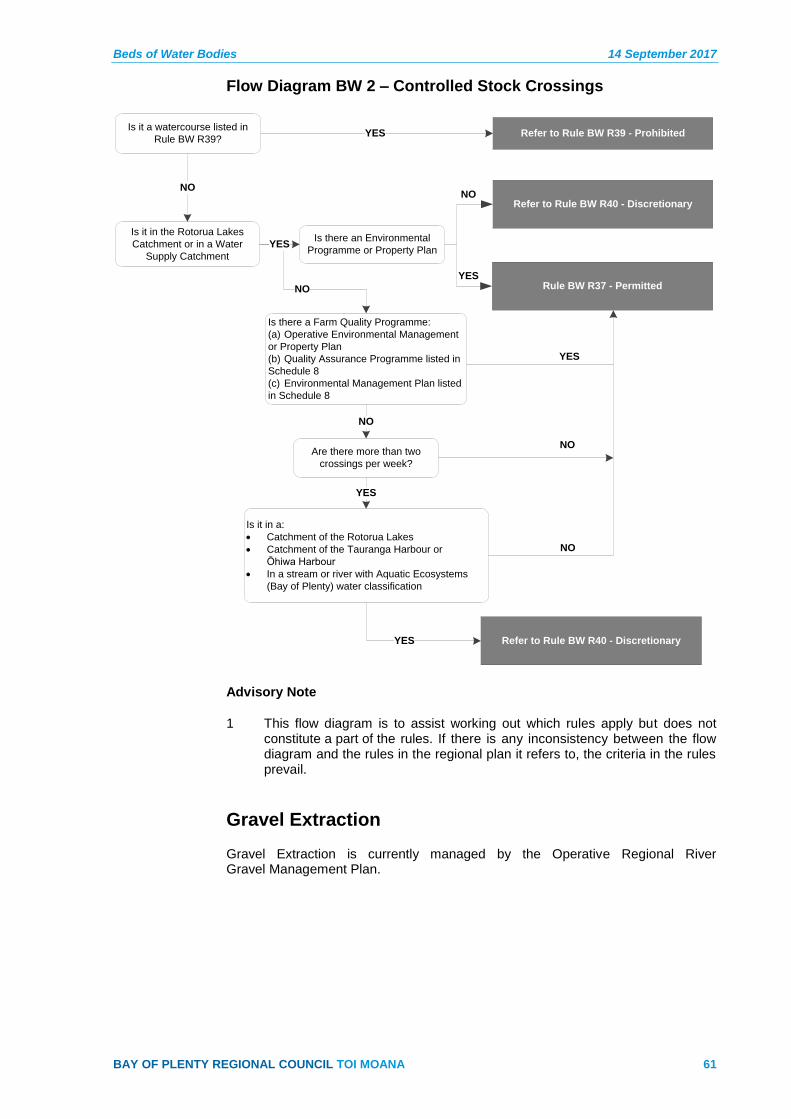
Beds of Water Bodies 14 September 2017
BAY OF PLENTY REGIONAL COUNCIL TOI MOANA 61
Flow Diagram BW 2 – Controlled Stock Crossings
Is it a watercourse listed in
Rule BW R39?
Is it in the Rotorua Lakes
Catchment or in a Water
Supply Catchment
Refer to Rule BW R39 - ProhibitedYES
NO
NO
Is there an Environmental
Programme or Property Plan
Is it in a:
Catchment of the Rotorua Lakes
Catchment of the Tauranga Harbour or
Ōhiwa Harbour
In a stream or river with Aquatic Ecosystems
(Bay of Plenty) water classification
YES
Refer to Rule BW R40 - Discretionary
Rule BW R37 - Permitted
Refer to Rule BW R40 - Discretionary
NO
YES
YES
Is there a Farm Quality Programme:
(a) Operative Environmental Management
or Property Plan
(b) Quality Assurance Programme listed in
Schedule 8
(c) Environmental Management Plan listed
in Schedule 8
NO
YES
Are there more than two
crossings per week?
YES
NO
NO
Advisory Note
1 This flow diagram is to assist working out which rules apply but does not constitute a part of the rules. If there is any inconsistency between the flow diagram and the rules in the regional plan it refers to, the criteria in the rules prevail.
Gravel Extraction
Gravel Extraction is currently managed by the Operative Regional River Gravel Management Plan.
