proposed 2 lot subdivision - statement of environmental
TRANSCRIPT
Proposed 2 Lot Subdivision -
Statement of Environmental
Effects
Lot 10 DP 758168
16 Imlay Street, Broulee
Prepared for: Richard Bryan
July 2021
Project No. 585
Prepared by
a: PO Box 96 Moruya NSW 2537
p: 02 4474 4439

Document Verification
Document title: Proposed 2 Lot Subdivision - Statement of Environmental Effects
Lot 10 DP 758168 16 Imlay Street, Broulee
Project number: 585
Prepared by: Brogan Addison & Lachlan Bain
Issue and date: A 21/07/2021
Issue to: Richard Bryan
Document history:
Commercial in Confidence
All intellectual property rights, including copyright, in designs developed and documents created by
Southeast Engineering & Environmental remain the property of Southeast Engineering &
Environmental. Any use made of any such design or document without the prior written approval of
Southeast Engineering & Environmental will constitute an infringement of the rights which reserves
all legal rights and remedies in respect of any such infringement.
The information, including the intellectual property, contained in this document is confidential and
proprietary to Southeast Engineering & Environmental. It may only be used by the person to whom
it is provided for the stated purpose for which it is provided, and must not be imparted to any third
person without the prior written approval of Southeast Engineering & Environmental. Southeast
Engineering & Environmental reserves all legal rights and remedies in relation to any infringement of
its rights in respect of its confidential information.
© 2021 Southeast Engineering & Environmental. 14 Mirrabooka Avenue Moruya NSW 2537
Disclaimer
This report is prepared by Southeast Engineering & Environmental for its clients' purposes only. The
contents of this report are provided expressly for the named client for its own use. No responsibility
is accepted for the use of or reliance upon this report in whole or in part by any third party.
This report is prepared with information supplied by the client and possibly other stakeholders.
While care is taken to ensure the veracity of information sources, no responsibility is accepted for
information that is withheld, incorrect or that is inaccurate. This report has been compiled at the
level of detail specified in the report and no responsibility is accepted for interpretations made at
more detailed levels than so indicated.

Contents
1.0 Introduction ..................................................................................................................... 1
2.0 Location and Existing Site Description ................................................................................ 2
3.0 The Proposal ..................................................................................................................... 6
3.1 Proposal overview ................................................................................................................... 6
3.2 Allotment layout, building envelopes and access ................................................................... 6
3.3 Services ................................................................................................................................... 6
4.0 Legislation, Policy and Development Controls .................................................................... 8
4.1 Environmental Planning and Assessment Act 1979 ................................................................ 8
4.1.1 Section 1.3 – Objects of the act ...................................................................................... 8
4.2 Eurobodalla Local Environmental Plan 2012 .......................................................................... 9
4.2.1 Zoning and land-use permissibility ................................................................................. 9
4.2.2 ELEP 2012 – General Aims .............................................................................................. 9
4.2.3 ELEP 2012 – Objectives of Zone .................................................................................... 10
4.2.4 ELEP 2012 – Principal Development Standards – Clause 4.1 Minimum subdivision lot
size 10
5.0 Environmental Effects ..................................................................................................... 11
5.1 Biodiversity Requirements .................................................................................................... 11
5.2 Vegetation ............................................................................................................................. 11
5.3 Flooding ................................................................................................................................. 11
5.4 Bushfire ................................................................................................................................. 12
5.5 Access .................................................................................................................................... 12
5.6 Sewage Management ........................................................................................................... 12
5.7 Water .................................................................................................................................... 12
5.8 Stormwater ........................................................................................................................... 13
5.9 Power and NBN ..................................................................................................................... 13
6.0 Conclusion ...................................................................................................................... 14
Appendix A – Proposed subdivision plan..................................................................................... 15

1
1.0 Introduction Southeast Engineering and Environmental (Southeast) has been engaged to prepare the Statement
of Environmental Effects (SEE) and civil engineering design for the proposed 2 allotment subdivision
on parent allotment Lot 10 DP 758168 16 Imlay Street, Broulee (The Site).
This report presents an analysis and investigation of the existing parent allotment and the Proposal.
This assessment has been prepared in consideration of planning legislation and development
controls pertaining to the locality. It involves an analysis of environmental, physical and social
implications of the proposal.

2
2.0 Location and Existing Site Description The site is located at the south of Broulee in an established urban residential area. (Figure 1).
Figure 1: Subject Site location (source: SIX Maps)

3
The Site is approximately 2020m2 with an existing residence. (Figure 2).
The existing house is connected to town water and sewer with access from Imlay Street.
Figure 2: Subject site (source: SIX maps)

4
The Site has a land use zoning R2 (Low Density Residential) with a minimum lot size of 550m2 as per
the ELEP 2012. (Figure 3)
Figure 3: Subject Site Zoning (ESC mapping)

5
Figure 4: Existing Site (looking from Imlay Street)
Figure 5: Existing Site (looking from Site back toward Imlay Street)

6
3.0 The Proposal
3.1 Proposal overview
The objective of the proposal to achieve sustainable and sensitive residential subdivision that meets
legislated planning requirements and responds to the Site’s landform, characteristics and
constraints.
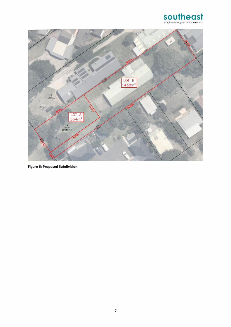
The proposal includes 1 new allotments (approx. 565m2) and the residual parent allotment (approx.
1458m2) that will retain the existing residence and driveway.
The proposed subdivision plan is shown in Figure 6 and Appendix A.
3.2 Allotment layout, building envelopes and access
The proposed allotment layout has been informed by thorough Site analysis including assessment of
potential flooding, existing vegetation and access.
The proposed new allotment is generally regular in shape (rectangular) with boundaries that allow
for a 4m wide battle-axe handle for the residual parent allotment.
The nominal building footprint provides optimal orientation (aligned with lot boundaries and Imlay
street) and allows for the majority of existing trees to be retained.
The parent allotment will retain the existing driveway access with a separate driveway proposed for
the new allotment.
Full road frontage for each new lot is provided.
3.3 Services
The proposal will have direct access to all reticulated utilities and have direct access to existing
sealed roads.
Consultation with Essential Energy and NBN providers will be undertaken post DA.
7
Figure 6: Proposed Subdivision

8
4.0 Legislation, Policy and Development Controls
4.1 Environmental Planning and Assessment Act 1979
4.1.1 Section 1.3 – Objects of the act
The objectives of the Act are as follows:
(a) to promote the social and economic welfare of the community and a better environment by
the proper management, development and conservation of the State’s natural and other
resources,
(b) to facilitate ecologically sustainable development by integrating relevant economic,
environmental and social considerations in decision-making about environmental planning
and assessment,
(c) to promote the orderly and economic use and development of land,
(d) to promote the delivery and maintenance of affordable housing,
(e) to protect the environment, including the conservation of threatened and other species of
native animals and plants, ecological communities and their habitats,
(f) to promote the sustainable management of built and cultural heritage (including Aboriginal
cultural heritage),
(g) to promote good design and amenity of the built environment,
(h) to promote the proper construction and maintenance of buildings, including the protection
of the health and safety of their occupants,
(i) to promote the sharing of the responsibility for environmental planning and assessment
between the different levels of government in the State,
(j) to provide increased opportunity for community participation in environmental planning and
assessment.
The proposal is considered to satisfy the Objectives of the Act by:
Providing residential allotments that responds to local demand;
Providing employment opportunities in the construction phase and providing long term
economic benefit for the local business community;
Supplementing the current urban adjoining environment and providing consistency in
allotment size and configuration; and
Utilising existing utilities that are available to service the Site.

9
4.2 Eurobodalla Local Environmental Plan 2012
The location of the land and the effect of local legislation places the proposed development under
the provisions of the Eurobodalla Local Environmental Plan 2012 (ELEP 2012).
4.2.1 Zoning and land-use permissibility
The Site is zoned R2 (Low Density Residential) with a minimum lots size of 550m2.
The proposed subdivision and associated civil works are permitted within the zoning.
4.2.2 ELEP 2012 – General Aims
The ELEP 2012 includes a number of general aims. These aims are summarised and a response
provided in Table 1.
Table 1: ELEP 2012 – Aims of Plan
(a) to preserve the urban growth boundaries of Eurobodalla as identified in the Eurobodalla Settlement Strategy;
The proposal is consistent with the defined growth directions for the Eurobodalla Settlement Strategy and zoning objectives within the ELEP.
(b) to ensure development embraces the principles of ecologically sustainable development and quality urban design, and encourages walking, cycling and public transport use;
The proposal is located adjacent to public road with school bus transport route. The proposal is located close to public reserves and beaches.
(c) to provide employment opportunities and strengthen the local economic base by encouraging a range of enterprises, including tourism, which respond to lifestyle choices, emerging markets and changes in technology;
There is high local demand for housing and rental accommodation due to population increase from a range of demographics (from young workers to retirees). The proposal responds to the demand for lifestyle choice with the location and lot size. The development will create employment opportunities in the construction phase and provided long term economic benefit for the local business community.
(d) to identify and protect the established residential neighbourhoods and ensure a sufficient supply of suitable land to meet the future residential needs of Eurobodalla;
The proposal is consistent with the local residential neighbourhood with regards to lot size and will have limited impact on neighbouring privacy and outlook. The proposal is consistent with the zoning objectives within the ELEP can contribute to the supply of sustainable land to meet the future residential demands
(e) to restrict development of land that is subject to flooding, coastline hazard, bush fires and land slip;
The proposal has considered flooding. The Site is not mapped as bushfire prone land.
(f) to ensure that resource lands, including agriculture, mineral resources and extractive materials are not rendered sterile from incompatible land use;
Potential resources have not been identified for the Site.
(g) to provide measures to protect and manage the biodiversity and environmental values of the land and waterways;
Existing trees to remain.
(h) to ensure that development takes into account the environmental constraints of the land and minimizes any off site and on-site impacts on biodiversity, water resources and natural landforms,
The proposal has considered the environmental constraints including flooding. Past clearing across the Site has altered the natural biodiversity and environment. Filling of the Site will slightly alter landform but not impact drainage.
(i) to identify and protect the cultural and architectural heritage of Eurobodalla, including Aboriginal relics and places, and assist in its promotion as a tourism asset.
There are no listed heritage items affected by the proposal. However, a Construction management Plan should include accepted protocols to manage any unexpected finds during project earthworks.

10
4.2.3 ELEP 2012 – Objectives of Zone
Table 2 provides a response to the objectives applicable under the R2 Low Density Residential zone.
Table 2: R2 Zone – Specific objectives
(i) To provide for the housing needs of the community within a low density residential environment.
There is high demand for low density residential housing and rental accommodation in Broulee due to population increase from a range of demographics (from young workers to retirees). The proposal responds to the demand for lifestyle choice with the location and lot size. The proposal is consistent with the R2 minimum lot size. This proposed allotment layout (with limited developable areas) ensures that the existing urban setting will be maintained and minimises the impacts on both environmental features and scenic qualities for neighbouring community.
(ii) To enable other land uses that provide facilities or services to meet the day to day needs of residents.
The proposal will not impact other land uses and will enable facilities/services to meet the day to day needs of residents
(iii) To encourage residential development that is consistent with the character of the neighbourhood.
The proposal will provide lot sizes and future dwelling that are consistent with the character of the local neighbourhood.
4.2.4 ELEP 2012 – Principal Development Standards – Clause 4.1 Minimum subdivision
lot size
Table 3 provides a response to the objectives of Clause 4.1 – Minimum subdivision lot size
Table 3: Clause 4.1 Minimum Subdivision Lot Size objectives
(a) to ensure that subdivision reflects and reinforces the predominant subdivision pattern of the area
The proposal is consistent with the local residential neighbourhood with regards to lot size and arrangement. Similar arrangement existing throughout Broulee.
(b) to ensure lot sizes and dimensions are able to accommodate development consistent with relevant development controls
The proposed new allotment is generally regular in shape (rectangular) with boundaries that are respectful of the natural land terrain characteristics and the nominal location of building footprints permitting optimal orientation for a future dwelling.
(c) to ensure that subdivision promotes effective land management practices and infrastructure provision
This proposed allotment layout ensures that the proposed development meets the goals and objectives of sustainable and minimal impact development. Existing utilities are available to service the Site.
(d) to protect native vegetation, natural watercourses and habitats for threatened species and populations, and endangered ecological communities
Past clearing across the Site has altered the natural biodiversity and environment. Filling of the Site will slightly alter landform but not impact drainage.

11
5.0 Environmental Effects
5.1 Biodiversity Requirements
Under the Biodiversity Conservation Act the amount of clearing of native vegetation on the site
cannot exceed 2500sqm (the site being less than 1 ha) without a Biodiversity Development
Assessment Report (BDAR) from an accredited ecologist. The total Site area (~2220sqm) is less than
the threshold therefore a BDAR is not required.
The Biodiversity Values Map online tool does not the Site as having high biodiversity value mapped.
5.2 Vegetation
One of the main objectives of the proposed subdivision and future dwelling is to retain as many
existing trees as possible. Refer Appendix A.
5.3 Flooding
Flood level information relevant to the Site was provided by Council including:
Residential Flood Planning Level (FPL) including freeboard for the property of 6.01 AHD;
The lot is subject to overland flow 1% AEP flood level 5.51 m less than 0.1m/s velocity, classified as low hazard; and
Any development is not to re-direct overland path or increase flows to neighbouring properties.
The proposal will include minor filling within the new allotment to accommodate future finished floor levels above the 1% AEP flood (Approx. RL 6.0m AHD). Refer Appendix A for details. The proposed filling will not re-direct overland flows or increase flows to neighbours as levels over the existing driveway will be retained providing an overland flow path from the existing house to Imlay Street, refer Figure 7.

12
Figure 7: Overland flow path behaviour maintained
5.4 Bushfire
Currently the Site is not mapped as bushfire prone land, in any case the Site has road frontage and
access to mains water.
5.5 Access
Access for the parent allotment will remain as per the existing driveway off Imlay Street (within the
proposed 4m wide battle axe handle). Access for the new lot will be via a new driveway also off
Imlay Street.
5.6 Sewage Management
The Site is connected to Council sewer and a new connection is proposed to service the new lot.
5.7 Water
The Site is connected to Council water and a new connection is proposed to service the new lot.
Levels over existing
driveway to be retained.
Providing an overland flow
path from existing
residence to Imlay Street
Existing residence
Proposed minor
filling to FPL

13
5.8 Stormwater
The existing residence has absorption trenches (wholly within the proposed residual parent
allotment).
A new stormwater connection to the existing Council stormwater pit on Imlay is proposed to drain
stormwater runoff from the new allotment and future dwelling.
5.9 Power and NBN
Consultation with the Essential Energy and NBN providers will be undertaken post DA.

14
6.0 Conclusion The proposal is for a 2 allotment subdivision on parent allotment Lot 10 DP 758168 16 Imlay Street,
Broulee. The proposal includes 1 new allotments (approx. 565m2) and the residual parent allotment
(approx. 1458m2) that will retain the existing residence and driveway.
Minor filling of the Site is required to achieve building envelopes above 1% AEP flood level. The
impact to flood behaviour from the proposed filling is considered negligible. The proposed filling will
not re-direct overland flows or increase flows to neighbours as levels over the existing driveway will
be retained providing an overland flow path from the existing house to Imlay Street
This SEE demonstrates that the proposal is consistent with relevant statutory planning requirements
and is unlikely to result in significant adverse impact on the local environment or neighbourhood.
The proposal is permissible development under Eurobodalla Local Environmental Plan 2012 (ELEP)
and achieves the objectives of the R2 zone.

Appendix A – Proposed subdivision plan