project summary seaside basin ground water · pdf filepage 5 project 2 – seaside...
TRANSCRIPT
Page 1 Project 2 – Seaside Groundwater Replenishment Project Proposal, June 21, 2005 Monterey Regional Water Pollution Control Agency
Project Summary
Seaside Basin Ground Water Replenishment Project (GRP) Sponsored by the
Monterey Regional Water Pollution Control Agency PROJECT TITLE: Seaside Basin Ground Water Replenishment Project PROJECT DESCRIPTION: The proposed Seaside Basin Groundwater Replenishment Project (GRP) involves the purification and conveyance of recycled water from MRWPCA’s Salinas Valley Reclamation Plant (SVRP) for recharge of the Seaside basin. Recycled water has been produced by the SVRP since 1998. That water has been delivered to 12,000 acres of farmland in the Castroville region of the lower Salinas Valley, where numerous non-processed food crops such as lettuce, broccoli, cauliflower, celery, artichokes, and strawberries are grown. This same reclamation plant could produce additional water, which would be treated to drinking water quality and either percolated or injected into the Seaside groundwater basin to help recharge that basin. Recycled water for the GRP would be delivered to the replenishment site through a recycled water trunkline that will be constructed under the Regional Urban Recycled Water Distribution Project (RURWP). The RURWP is described in the Planning Grant application submitted by the MPWMD, and is one of the projects that will be included in the Second Round Implementation Grant application that will be submitted by the Monterey County Water Resources Agency (MCWRA). In addition to providing irrigation water to numerous golf courses, parks, and landscaped areas in the Marina, Fort Ord, Seaside, Del Rey Oaks, and Monterey areas, the RURWP will also be able to deliver recycled water for the GRP. The GRP is included in this Implementation Grant application because it is located within the region covered by this application, even though the recycled water for the GRP would be delivered through the trunkline of the RURWP that is one of the projects which will be included in the MCWRA’s Second Round Implementation Grant Application.
The GRP and the RURWP would work together to expand water recycling in this area. Working together the two projects will reduce the demand for potable water and also augment the potable water supply. The GRP would also work in parallel with the MPWMD’s ASR project which is a separate project described in this Implementation Grant application. The Seaside basin is a major element of the water supply for the Monterey Peninsula cities. The GRP, along with the ASR project, would augment that water supply and also help mitigate seawater intrusion which is working its way into that basin. A more complete description of the GRP is provided in Attachment 1. Also included in Attachment 1 is a map showing the location of the GRP facilities within the Planning Region for this Grant Application. The GRP is in the planning stage. An initial feasibility study has been completed (“Feasibility of Using Recycled Water to Recharge the Seaside Groundwater Basin in Monterey County”, dated September, 2004 prepared by William R. Mills, PE, RG, DDE,

Page 2 Project 2 – Seaside Groundwater Replenishment Project Proposal, June 21, 2005 Monterey Regional Water Pollution Control Agency
contained in Attachment 1). The feasibility study was for an ultimate project that could recharge up to 4,000 AFY. The GRP which is described in this Project Summary is for the initial 2,800 AFY of that larger project. It is anticipated that this is the volume of water that will be available for recharge over approximately the next ten years. Follow-on work is in progress involving coordination with other agencies, analyzing available hydrogeologic data for the proposed recharge sites, identification of environmental, permitting, and approval issues, development of criteria and parameters for a pilot-scale recharge facility, and preparation of a design report. PROJECT DIRECTOR: Robert S. Jaques Director of Engineering Planning and Technology Monterey Regional Water Pollution Control Agency 5 Harris Court, Bldg. D Monterey, CA 93940 email [email protected] Telephone: (831) 645-4607 FAX: (831) 372-6178 GRANT FUNDS REQUESTED: $2.2 million in Round 1 of Implementation Grants, as shown in Attachment 3B (with $22.0 anticipated being requested in Round 2 of Implementation Grants – see discussion of this in the detailed Project Description.) LOCAL COST MATCH: $0.05 million local cost match in the Round 1 Implementation Grant Application, as shown in Attachment 3B (with $2.65 million local cost match anticipated being provided in the Round 2 Implementation Grant Application - see discussion of this in the detailed Project Description.) The local cost match will be comprised of staff labor and local capital funding contributions from either cash reserves or debt-financing. TOTAL BUDGET: $26.9 million, as detailed in Attachment 3A. PROJECT GOAL(S) AND BENEFIT(S): The principle goals and objectives of the GRP are to:
• Increase the amount of water that is recycled in the region; • Increase the amount of water available from the Seaside Ground Water Basin for
pumping by existing or new domestic wells; • Help reduce the amount of over drafting of the Carmel River basin, as required
by SWRCB Order WR 95-10; • Reduce the amount of treated effluent that is discharged to Monterey Bay and
the Monterey Bay National Marine Sanctuary; SCHEDULE: Planning work for the GRP is already in progress and construction of the GRP’s facilities is scheduled to be completed in late-2010 as shown in Attachment 2 which includes activities and/or milestones yet to be completed before a grant contract would be executed. COORDINATES: 36o 35’ north latitude; 121o 50’ west longitude

Page 3 Project 2 – Seaside Groundwater Replenishment Project Proposal, June 21, 2005 Monterey Regional Water Pollution Control Agency
WATERSHED: Seaside Groundwater Basin COUNTY: Monterey COOPERATING ENTITIES: The GRP will be sponsored by and carried out by the Monterey Regional Water Pollution Control Agency, and will be closely coordinated with the Monterey Peninsula Water Management District. PROJECT CATEGORY: The GRP will be consistent with the Recycling/treated Wastewater Strategy described in Section 5.7 of the “Work Plan for the Monterey Peninsula, Carmel Bay, and South Monterey Bay Integrated Regional Water Management Plan and Integrated Coastal Watershed Management Plan, May 12, 2005,” which was prepared and submitted by the MPWMD with its Planning Grant application. PROJECT STATUS: The GRP is currently in the planning stage, with an initial feasibility study already completed (see Attachment 1) and subsequent work in progress. The Schedule contained in Attachment 2 shows the planned dates for completion of the remaining planning steps including CEQA and NEPA compliance, the preparation of design documents, acquisition of permits and approvals, and construction of facilities.

Page 4 Project 2 – Seaside Groundwater Replenishment Project Proposal, June 21, 2005 Monterey Regional Water Pollution Control Agency
ATTACHMENT 1
PROJECT DESCRIPTION
Page 5 Project 2 – Seaside Groundwater Replenishment Project Proposal, June 21, 2005 Monterey Regional Water Pollution Control Agency
SEASIDE BASIN GROUNDWATER REPLENISHMENT PROJECT
Project Description The proposed Groundwater Replenishment Project (GRP) for the Seaside groundwater basin involves the purification and conveyance of recycled water from MRWPCA’s Salinas Valley Reclamation Plant (SVRP) for recharge of the Seaside basin. The product water would meet all drinking water standards prior to groundwater recharge. State guidelines for groundwater recharge of purified recycled water require that the water be blended with water from non-wastewater sources. The blend water could come from the Seaside basin or Carmel River water that would be injected into the Seaside basin for recharge purposes by the MPWMD. This would increase the amount of water available from this basin for pumping by existing or new domestic wells. During the summertime, the SVRP produces tertiary treated water from the effluent of the Regional Wastewater Treatment Plant. This recycled water meets all State and Federal standards for irrigating golf courses, parks, schools, and agricultural crops, including non-processed food crops which may be eaten raw. Currently, only agricultural applications are made, as a conveyance and distribution system for urban uses does not exist. However, construction of an urban water supply system, the Regional Urban Recycled Water Project, to provide irrigation water for the southern Monterey Bay area has been in the planning stages for many years. A water demand analysis shows that even with the development of the urban project, the combined agricultural and urban demands for irrigation water in the wintertime would be minimal. Thus, the SVRP would not be operated in the wintertime unless a project is constructed to utilize the wintertime volumes. In the near-term it is estimated that after the construction of the proposed urban system, about 2,800 AFY of SVRP water could still be produced in excess of the existing agricultural and potential urban demands. This quantity could be available for purification and groundwater recharge. Ultimately, it is anticipated that as much as 4,000 AFY could be available for recharge. Recycled water from the SVRP would be purified by an advanced wastewater treatment plant (AWT). The AWT would most likely be constructed adjacent to the SVRP, although alternate locations will be considered during preliminary design. The AWT would process water to meet all State and Federal drinking water standards and the California Department of Health Services (DHS) requirements for groundwater recharge. The treatment processes would most likely include reverse osmosis (RO) for the removal of dissolved salts, microorganisms, and other constituents. An ultraviolet disinfection system would be provided to meet bacterial requirements and for destruction of organic compounds. The ultraviolet system might be coupled with the addition of hydrogen peroxide, if necessary to improve its effectiveness. The SVRP should provide adequate pretreatment for the RO process. However, it may be desirable to include pretreatment with microfiltration to reduce biofouling of the RO membranes.
Page 6 Project 2 – Seaside Groundwater Replenishment Project Proposal, June 21, 2005 Monterey Regional Water Pollution Control Agency
The purified water would be recharged either through surface recharge basins or by injection wells. In either case, the recharge facilities would be constructed on the former Fort Ord, east of General Jim Moore Boulevard. The selected recharge method would depend on the findings of surface recharge pilot testing. The two groundwater recharge concepts are:
Direct Injection into the Aquifers: MPWMD’s pilot ASR demonstration project has shown that direct injection of potable water into the Santa Margarita aquifer is feasible. This aquifer is the primary groundwater supply in the Seaside basin. The pilot project is part of a proposed project, known as the Seaside Basin Storage and Recovery Project, which proposes to inject surplus Carmel River water into the aquifer with subsequent extraction by dual purpose wells. Purified recycled water could also be injected into the Santa Margarita aquifer. However, the underground retention period required by DHS dictates that the extracted water could not be withdrawn for a period of 12 months and must not be extracted within 2,000 feet from the point of injection. Thus, the groundwater replenishment injection well locations would need to be sited to ensure compliance with the DHS guidelines. Surface Recharge using Recharge Basins: The U.S. Geological Survey has previously investigated the feasibility of surface recharge in the Seaside basin. While their investigation was not exhaustive, the study indicated that surface recharge was possible and concluded that most of the natural recharge to the basin was from surface recharge of rain water. The investigation estimated that 75% of the recharge to the basin occurs from rainfall.
The former Fort Ord area east of General Jim Moore Boulevard appears to be well suited for surface recharge. The U.S. Department of Agriculture soil survey for Monterey County describes the soils in this area, which consist of stabilized sand dunes, as exhibiting infiltration rates from 6 to 20 inches/hour. Further, there exist a number of surface depressions on this former Fort Ord site that could be used as recharge basins. Recharge water would travel downward through the Aromas Sand into the Paso Robles Formation and then probably into the Santa Margarita. (The percolation pathways into this confined Santa Margarita aquifer are not currently well defined.) The percolation of the AWT water through the Aromas Sands would further purify the percolating waters. While the upper layers of soil are conducive to surface recharge, subsurface clay lenses within the underlying aquifers could serve to possibly inhibit or retard the downward percolation of water. Therefore, if this recharge method is selected for further consideration it would be necessary to perform a pilot recharge test to determine the degree of retardation provided by these restricting layers. The purified water would be transported to the groundwater recharge or injection site via a pipeline during the winter period when agricultural and urban irrigation demands are minimal. The RO process usually rejects about 10% of the influent as a brine stream. The brine stream would most likely be discharged into the brine disposal facility at

Page 7 Project 2 – Seaside Groundwater Replenishment Project Proposal, June 21, 2005 Monterey Regional Water Pollution Control Agency
MRWPCA’s Regional Wastewater Treatment Plant, although alternate disposal methods will be considered during preliminary design. The initial feasibility study of the GRP (“Feasibility of Using Recycled Water to Recharge the Seaside Groundwater Basin in Monterey County”, dated September, 2004 prepared by William R. Mills, PE, RG, DDE) is included at the end of this Attachment 1. Eligible Water Management Elements The GRP meets the objectives of protecting communities from drought and improving local water security by reducing dependence on imported water. More specifically, the GRP will help to accomplish the following water management elements, as prescribed in Section III.C of the November 2004 Grant Program Guidelines: Programs for water supply reliability, water conservation, and water use efficiency; Programs for water supply reliability, water conservation, and water use
efficiency; Groundwater recharge and management projects; Contaminant and salt removal through reclamation, desalting, and other treatment
technologies; Water banking, water exchange, water reclamation, and improvement of water
quality; Watershed management planning and implementation; and Demonstration projects to develop new drinking water treatment and distribution
methods. Project Goals and Objectives The principle goals and objectives of the GRP are to:
• Increase the amount of water that is recycled in the region; • Increase the amount of water available from the Seaside Ground Water Basin for
pumping by existing or new domestic wells; • Help reduce the amount of over drafting of the Carmel River basin, as required
by SWRCB Order WR 95-10; • Reduce the amount of treated effluent that is discharged to Monterey Bay and
the Monterey Bay National Marine Sanctuary; Relationship to IRWM Plan Consistency with the IRWM Plan The GRP will be consistent with the IRWM Plan being prepared by the MPWMD, and is specifically described in the following Sections of MPWMD’s “Work Plan for the Monterey Peninsula, Carmel Bay, and South Monterey Bay Integrated Regional Water

Page 8 Project 2 – Seaside Groundwater Replenishment Project Proposal, June 21, 2005 Monterey Regional Water Pollution Control Agency
Management Plan and Integrated Coastal Watershed Management Plan, May 12, 2005,” which was included with MPWMD’s Planning Grant application (hereinafter referred to as the “MPWMD Work Plan“):
• Section 4.3.2 – Expand water reclamation efforts • Section 5.7.2 – Seaside Groundwater Replenishment Project
Achievement of IRWM Plan objectives The GRP will fit into achieving the following objectives described in Section 4.0 of the MPWMD Work Plan:
• Section 4.2.1 – Maintain sustainable yield in the Seaside Groundwater Basin • Section 4.3.2 – Expand water reclamation efforts • Section 4.5.5 – Complete Seaside Groundwater Basin Management Plan • Section 4.7.1 – Comply with SWRCB Order WR 95-10
Scientific Basis for the Project The GWR is being patterned after the highly successful and widely respected “Water Factory 21” project constructed and operated by the Orange County Water District in southern California. Water Factory 21 is a 15 mgd advanced wastewater reclamation facility which has supplied fresh water for sea water barrier and groundwater basin recharge continuously since 1975. It has produced over 150,000 acre-feet of water for extraction by domestic wells. Water Factory 21 produces water that meets all drinking water standards. Because of its success the Orange County Water District is now constructing a new groundwater replenishment project that will replace Water Factory 21 with an 80 mgd advanced water recycling system which will incorporate technical advances that have occurred since Water Factory 21 was constructed. The GRP will employ the same types of processes and technical advances that are being used in Orange County Water District’s new facilities. Compliance with Applicable Environmental Review Requirements As shown in the Schedule contained in Attachment 2 and the Cost Estimate contained in Attachment 3 one of the planning steps for the GRP will be to prepare and certify the necessary documents, which are expected to be a joint EIR/EIS to satisfy all applicable CEQA and NEPA requirements. The NEPA requirements are expected to apply, because the proposed recharge site is located on Federal lands. Metrics to be Used to Show Measurable Water Supply Improvement The quantities of recycled water that are used to replenish the Seaside Groundwater Basin will be measured and recorded in accordance with RWQCB permit requirements for this type of project. MPWMD will continue its current program of monitoring

Page 9 Project 2 – Seaside Groundwater Replenishment Project Proposal, June 21, 2005 Monterey Regional Water Pollution Control Agency
groundwater levels and groundwater quality in this basin. The increased amount of water that can be pumped from the basin as a result of the GRP will be determined by comparing well pumping records from before and after the GRP is implemented. Collectively, this information will enable the benefits of the GRP in terms of groundwater supply improvement to be quantified. How the Project Will be Carried Out The GWR will be carried out in the following three phases (referred to as Tasks in the Schedule contained in Attachment 2): Task 1 – The Planning Phase. This phase will include coordination with other agencies, preparation of feasibility studies and other preliminary technical reports, pilot testing, CEQA and NEPA compliance processes, and preparation of the final design report that will serve as the basis for Task 2 – The Design Phase. Task 2 – The Design Phase. This phase will include preparation of plans and specifications for the full-scale GWR project, obtaining of all necessary permits and approvals, and obtaining necessary right-of-way upon which to construct the GWR facilities. Task 3 – The Construction Phase. This phase will include bidding, contract award, construction, and start-up. Each of these tasks is shown in the Schedule (Attachment 2) and in the Cost Estimates in (Attachment 3). Project Need As noted above the GWR project is needed to help achieve several of the objectives described in Section 4.0 of the MPWMD Work Plan:
• Section 4.2.1 – Maintain sustainable yield in the Seaside Groundwater Basin • Section 4.3.2 – Expand water reclamation efforts • Section 4.5.5 – Complete Seaside Groundwater Basin Management Plan • Section 4.7.1 – Comply with SWRCB Order WR 95-10
The GWR project is also needed to help the Monterey Regional Water Pollution Control Agency (MRWPCA), the regional wastewater services provider, achieve its goal of recycling 100% of its wastewater. Achieving this goal will nearly eliminate the discharge of treated effluent from MRWPCA’s service area to Monterey Bay and the Monterey Bay National Marine Sanctuary, and will greatly help solve critical water supply problems facing the region covered by the “Work Plan for the Monterey Peninsula, Carmel Bay, and South Monterey Bay Integrated Regional Water Management Plan and Integrated Coastal Watershed Management Plan, May 12, 2005,” which was prepared and submitted by the MPWMD with its Planning Grant application.

Page 10 Project 2 – Seaside Groundwater Replenishment Project Proposal, June 21, 2005 Monterey Regional Water Pollution Control Agency
Environmental Compliance The recharge facilities for the GWR are proposed to be located on Federal lands within the former U.S. Army installation at Fort Ord. MPWMD’s previous experience installing ASR test wells in this same vicinity indicate that because of the involvement of Federal lands, compliance with both CEQA and NEPA requirements will be necessary. An environmental firm that is fully qualified to prepare and process the required documents will be hired to manage and conduct these activities. Experience gained by MPWMD with its ASR project will be drawn upon to assist in carrying out this work. Compliance with local, County, State, and Federal permitting requirements will be accomplished by (1) meeting with representatives of each of the entities to brief them on the proposed GWR project, (2) obtaining from them their list of concerns and issues that will have to be addressed in their permits or approval documents, and (3) preparing and submitting to them the necessary reports, plans, specifications, and other documents, along with the required permit applications, in order to secure their approvals and obtain the necessary permits. These activities are shown on the Schedule and are included in the Cost Estimate. Funding Match As noted in Attachment 3A the total budget for the GRP is $26.9 million. The amount of grant funds being requested in this first round of Implementation Grant Applications is $2.2 million to help cover costs expected to be incurred during the Planning and Design phases of the work. The MRWPCA intends to provide a local match of $0.05 million during the performance of the Planning and Design phase work through staff labor and/or cash reserves. These grant and local match amounts should complete the Planning and Design Phases as shown in Attachment 2 and Attachment 3B. The intent is to submit an Implementation Grant Application in the second round for the remainder of the project (the Construction phase), which would be comprised of $2.65 million in local match and $22.0 million in grant funding. The local cost match for the Construction phase will be comprised of staff labor and local capital funding contributions from cash reserves and/or debt-financing. The proposed local cost match of $2.7 million for the full project exceeds the 10% minimum required local cost match. The MRWPCA has planned, designed, and constructed numerous large capital projects over its 30+ years of existence including $75 million of interceptor pipelines and pump stations, a $55 million regional wastewater treatment plant, and a $30 million regional water recycling plant. Debt-financing for the local cost share of these projects was provided through the sale of either revenue bonds or capital finance bonds. These same debt-financing approaches would be used to provide a portion of the funding match for the GWR project. The remainder of the funding match would be provided through staff labor and cash reserves to help cover other costs shown in the Cost Estimate.

PROJECT LOCATION MAP
Page 11 Seaside Groundwater Replenishment Project Proposal, June 21, 2005 Monterey Regional Water Pollution Control Agency
SALINAS
SEASIDE
MARINA
MONTEREY
MONTE FOREST
PACIFIC GROVE
BORONDA
SAND CITY
DEL REY OAKS
SPRECKELS
LEGEND
PIPELINE TO GROUNDWATERRECHARGE SITES
PIPELINE TO URBAN REUSE SITES
LATERALS TO URBAN REUSE SITES
PROPOSED GROUNDWATER RECHARGEBASIN OR RECHARGE WELL SITES
JOINT URBAN REUSE ANDGROUNDWATER RECHARGE TRUNKLINE
ADVANCED WASTEWATERTREATMENT PLANT

Page 12 Seaside Groundwater Replenishment Project Proposal, June 21, 2005 Monterey Regional Water Pollution Control Agency
Feasibility of Using Recycled Water to Recharge the Seaside Groundwater Basin in Monterey County – September, 2004
By
William R. Mills PE, RG, DDE
Purpose of the Study The purpose of this study is to determine the feasibility of recharging the Seaside Basin with recycled water derived from the Salinas Valley Reclamation Plant (SVRP) through well injection and/or spreading basins. The SVRP is owned and operated by the Monterey Regional Water Pollution Control Agency (MRWPCA).
Hydrogeology The USGS (Ref. 9) performed an early and comprehensive investigation of the ground water resources of the Seaside Ground Water basin (1982). A number of other investigations have been conducted since that time. These have refined some of the quantitative information in the USGS report. The USGS report delineates the groundwater basin as containing four weakly consolidated geologic formations located above the bedrock formation of the Monterey Shale. These water bearing formations, from oldest to youngest are: the Santa Margarita Sandstone, the Paso Robles Formation, the Aromas Sand and older dunes. All of these are considered to yield significant quantities of water and are described as follows: The Santa Margarita Sandstone is a well-sorted, fine-to-coarse sand containing little clay. It has a thickness of up to 200 feet. The sandstone aquifer is divided into upper and lower units. (Ref.10). A subsequent report indicates that the hydraulic conductivity of the Santa Margarita is about 5 times greater than that of the Paso Robles formation (Ref. 4). The sandstone formation is described as a confined aquifer (Ref.4). The Paso Robles formation is interbedded sand, gravel, and clay with a thickness of up to 700 feet. The formation is divided into an upper and lower unit, separated by a clay layer with a thickness of up to 150 feet (Ref.10). This formation is described as unconfined or semi confined aquifer (Ref 4). The Aromas Sand is a formation interbedded with clay and gravel and up to 300 feet in thickness. The Aromas and the Paso Robles are difficult to distinguish between and are usually shown as one unit. The two units are considered to be hydraulically interconnected (Ref. 10).

Page 13 Seaside Groundwater Replenishment Project Proposal, June 21, 2005 Monterey Regional Water Pollution Control Agency
The older dunes form the surface over a large part of the Seaside area. These are considered to be reworked windblown Aromas Sand. Its thickness varies up to 300 feet. Subsequent investigators have divided the basin area into two subbasins that are hydrogeologically separate (northern and southern subbasins). The subbasins have been further divided into five subareas based on hydrology and political criteria (Ref. 18).
Surfical Soils The soil survey for Monterey County was obtained and reviewed for soil infiltration characteristics (Ref. 19). The surfical soils in the area east of General Jim Moore (GJM) Blvd are classified as Baywood soil series having infiltration rates from 6 to 20 inches/hour. As described later in the report, this area may be a potential location for surface recharge facilities.
Basin Water Supply
The USGS investigation concluded that the basin is recharged by infiltration of rain, seepage from streams, and inflow from adjacent areas with infiltration of rain accounting for about 75% of the total recharge to the basin (Ref. 9). The investigation also indicated an annual recharge rate ranging from about 6,400 to 7,700 afy. More recent investigations have placed the average annual yield at about 4,400 afy (Ref. 18)
Recycled Water Availability and Quality MRWPCA operates a regional secondary wastewater treatment plant (RTP) that processes approximately 21 mgd of wastewater collected from the Monterey area. Additionally, the agency operates a tertiary reclamation plant, the Salinas Valley Reclamation Plant (SVRP) that provides tertiary treatment to all water from the RTP. The recycled water produced by the SVRP meets all requirements for unrestricted use for landscape and agricultural irrigation. The plants are located to the north of the Seaside Basin. A portion of the product water from SVRP is delivered to agricultural areas north of the facility. Currently, about 10,000 afy of product water from the SVRP is discharged into the ocean. Under a proposed urban reuse project (Ref. 20), about 5,000 afy of the surplus production capacity of the Salinas Valley Reclamation Plant would be delivered southward to existing landscape irrigation areas via a reclaimed water distribution system. However, during the winter season, the urban demand would fall below the pants capacity, thus creating surplus water availability for ground water recharge and subsequent recovery.
Recharge of the Basin with Recycled Water Recharge of groundwater basins can be accomplished by either a direct injection method, using wells, or a surfical method, using recharge basins. Recharge basins are also known as ‘spreading’ basins. Subsurface geologic conditions usually dictate the method of recharge. In general, where subsurface conditions are favorable, surfical recharge is more desirable than direct injection since it is less operationally difficult and usually less expensive.

Page 14 Seaside Groundwater Replenishment Project Proposal, June 21, 2005 Monterey Regional Water Pollution Control Agency
Several investigations have been conducted to examine the feasibility of the concept of Aquifer Storage and Recovery (ASR) in the Seaside basin area. This technique is generally defined as injecting surplus water into an aquifer via one or more injection wells. The water is subsequently extracted, using the same wells, but at a later time. The time frame could be on an annual/seasonal basis or over a longer period of time such as from a series of wet years to a drought period. The ASR concept also includes recharge, via injection wells or surfical spreading grounds, and subsequent withdrawal by domestic or irrigation wells located downgradient from the recharge area. This is commonly practiced in Los Angeles and Orange Counties. In these areas, injection takes place along the coast to prevent sea water intrusion and surfical recharge takes place in the inland areas of the basin where subsurface conditions area favorable. In both instances, the injected water is a supplemental water supply to the basin. With respect to sea water intrusion control projects, however, about 10-15% of the injected water is lost to the ocean. Direct Injection Recharge: The feasibility of direct injection into the Santa Margarita aquifer has been previously demonstrated. (Ref. 4). Regarding the latter demonstration test, an injection rate of about 1,000 gpm was sustained, provided weekly back flushing cycles were employed. The demonstration was conducted using treated water from the Carmel River. The water was relatively free of suspended sediments as indicated by low silt density index (SDI) test. Surfical Recharge: As indicated, in areas where the underlying soils or geologic strata are conducive to downward percolation of water, surface recharge is typically employed. Extensive recharge areas in Southern California and in the Central Valley have been developed to replenish the underlying groundwater basin using this method of recharge. It appears that this method of recharging in the Seaside Basin has not been considered as no mention in the literature has been found. However, the USGS (Ref. 9) investigation indicated that about 75% of the natural recharge to the basin occurs through rain infiltration. In addition, the investigation stated that one of its purposes was to ‘identify areas where recharging with imported or surplus waters would be most successful.’ Accordingly, the investigation analyzed the characteristics that affect surface recharge: slope of the topography, soil infiltration capacity and hydrogeological conductivity of the surfical sediments. The result was presented in the form of a map showing areas considered to be good, fair or poor for surface recharge. A review of this map indicates that nearly all of the undeveloped surface area of the Seaside basin is considered good for recharge. As indicated earlier, the surface soils are characterized as having a relatively high infiltration rate. However, subsurface clay lenses may inhibit or restrict the downward percolation of water. Several monitoring wells have been constructed in the area east of GJM Blvd by the Monterey Peninsula Water Management Agency (MPWMA). The wells were geologically and electrically logged. A review of these data for MPWMD Fort Ord monitoring wells nos. 7,8,10 and 11 show existence of a number of clay and silt layers between the surface and the Paso Robles aquifer which may retard the downward percolation of water. The thickness of the sediments overlying the Paso Robles ranging from 200 to 400 feet.

Page 15 Seaside Groundwater Replenishment Project Proposal, June 21, 2005 Monterey Regional Water Pollution Control Agency
Regulatory Constraints A number of permits are required to implement a groundwater recharge project into a domestic water supply aquifer. These include the California Department of Health Services (DHS), the California Regional Water Quality Control Board, Central Coastal Region and the County of Monterey. California Department of Health Services (DHS): While DHS does not issue a permit for a recharge project involving recycled waters, their requirements are incorporated into the permit issued by the Regional Board. The DHS requirements are the most stringent of those required. DHS requires an extensive Engineering Report consisting of a comprehensive investigation and evaluation of the recharge project, its impacts on the existing and potential uses from the basin and the proposed means of compliance with the DHS requirements. DHS has been struggling with the issuance of a final ‘regulations’ for groundwater recharge for many years. ‘Blue Ribbon’ panels have been assembled from time to time to assist in the process but final regulations are still a work-in-process. As a side note, the tentative regulations have become more science based as a result of an enormous amount of research accomplished by the Orange County Water District (OCWD) in the last decade. Primary concerns of DHS include: virus attenuation and dissolved organics (including ‘constituents of concern’) elimination. (Their most recent draft regulations are dated July of 2003 and are attached to this report.) Control of Pathogenic Microorganisms: The pathogenic concern is met, in addition to requiring wastewaters to be filtered and disinfected, by providing sufficient residence time in the aquifer before the water is extracted for domestic use. While it can be argued that advanced water treatment processes are effective in destroying viruses, their presence is extremely difficult to detect due to their minute size which make the detection processes difficult. Thus, DHS takes the position that virus could be present and therefore a significant detention period and travel distance should provide an adequate safe guard. A long detention period and travel distance has been found to adequately attenuate virus. Thus, current DHS draft regulations for direct injection require 12 month retention or travel time to the nearest domestic extraction well prior to extraction. For surfical recharge projects, if an adequate vadoze zone (unsaturated) exists above the domestic aquifer, the travel time (retention) of 6 months is deemed adequate. As previously mentioned, the vadoze zone in the area east of GJM Blvd is several hundred feet in thickness and should satisfy this requirement. Travel times between recharge projects and extraction wells can be estimated using information about the hydrogeologic properties of the aquifer. However, estimated travel times must be confirmed through the use of ‘tracers’ testing. This entails the construction of two or more wells; one at the proposed recharge site and one or more monitoring wells located at appropriate distances downgradient from the injection well. Subsequent to the well construction, a ‘tracer’ chemical is injected and samples are extracted from time to time from the downgradient monitoring wells and from existing extraction wells. Tracer compounds include a variety of non-toxic compounds, such as water containing isotopes of oxygen or hydrogen.

Page 16 Seaside Groundwater Replenishment Project Proposal, June 21, 2005 Monterey Regional Water Pollution Control Agency
Control of Nonregulated Chemicals: Dissolved organics occur in treated wastewater in trace concentrations. Some constituents, for example Nitrosodiethylamine (NDMA), are known cancer causing chemicals at a concentration of 20 ppt. Additionally, new emerging contaminants (constituents of concern) may become regulated as their health effects become known and analytical detection levels improve. To counter the threat of dissolved organics in recycled water to be used in a groundwater recharge project, the DHS has adopted a three prong strategy: 1) the dilution of the recycled water with waters of non-wastewater origin, 2) an effective source control program that regulates toxic discharges into the collection system and 3) the provision of an adequate vadoze zone for surface spreading and best available treatment technology for direct injection. Each of these strategies are discussed in the following:
Dilution Water: As indicated, DHS requires that recycled water for recharge to a domestic aquifer be diluted with water of non-wastewater origin, such as the Carmel River or waters from the Cal Am distribution system. The dilution is expressed as a percentage of the total recharge. The dilution percentage is 50 percent. However, this dilution percentage may be reduced after a period of operational experience. For direct injection, the blending must be accomplished prior to injection even if the retention time in the aquifer greatly exceeds the DHS minimum requirements. For spreading projects, it may be possible to utilize the natural recharge to the basin as the blend water.
Source Control: DHS also desires an effective source control program that would ensure to the greatest extent that toxic and other deleterious chemicals are not introduced into the collection system. Thus, the wastewater collection and treatment agency desiring to implement groundwater recharge projects must demonstrate the efficacy of their source control program.
Dissolved Organics and Nitrogen Removal: Draft regulations for surface recharge include limitations on the concentrations of Total Organic Compounds (TOC) and nitrogen. For surface spreading recharge projects, DHS may rely on natural treatment occurring in the vadoze zone to reduce these concentrations to acceptable levels. (The County of Monterey, as discussed in the following, has its own nitrate requirement that must be satisfied.) DHS regulations require greater TOC reductions in the wastewater as the percentage of wastewater increases in the recharge blend. In general, the DHS limits the concentration of total nitrogen to 5 mg/L (as nitrogen) in the recharge water, but recognizes that natural soil treatment may reduce the nitrogen concentration before it merges with the local groundwater. Thus, greater concentrations may be allowed if it can be demonstrated that the nitrogen concentration in the recharge water meets drinking standards prior to merging with the native groundwater or extracted by the nearest drinking water well. The draft regulations for direct injection are specific as to the treatment technology. Reverse Osmosis is required for all wastewater. Further, if it is desired at some future time to increase the percentage of wastewater above the 50% level, ultra-violet (UV) treatment coupled with the prior addition of Hydrogen Peroxide are required. These combined treatment processes effectively reduce the nitrogen and TOC to below the limits specified by DHS. DHS has

Page 17 Seaside Groundwater Replenishment Project Proposal, June 21, 2005 Monterey Regional Water Pollution Control Agency
approved a groundwater recharge project in Orange County using this treatment scheme, as discussed later. Regional Water Quality Control Board, Central Coastal Region: Each Regional Board of the State has adopted a Basin Plan. These contain water quality objectives for groundwater basins. These objectives include, but are not limited to, objectives for TDS, nitrates and other inorganic constituents for each groundwater basin. In general the objectives are set in accordance with State and Federal ‘non-degradation’ philosophy. Thus, recharge projects must comply with the basin objectives. However, both State and Federal statutes allow some degradation from these objectives if it can be demonstrated that ‘maximum benefit’ to the population of the state would occur if the degradation were allowed. Generally, reclamation projects have been allowed to exceed the basin objective under this provision. For example, a project in Orange County, CA, was allowed by the Santa Ana Regional Water Quality Control Board to inject recharge waters at concentrations that meet the USEPA primary drinking water standards, even though the recharge waters exceeded the water quality objectives for that portion of the basin. The local Regional Board has not adopted basin objectives for the Seaside groundwater basin, but would do so if a groundwater recharge were proposed. This would entail a compilation and analysis of water quality parameters from all existing wells. The most difficult water quality parameter to meet is TDS. Thus, if water treatment processes are required to reduce the TDS in the recharge water, in general, all other water quality parameters will also be met.
According to one source (Ref. 18), the average TDS quality of the Paso Robles and Santa Margarita formations are about 300 and 600 mg/L, respectively. It is likely that the basin objectives will be established at the lesser TDS level. If the Regional Board established the basin objectives at these levels, it might allow the recharge water to exceed these levels based on the maximum benefit concept, but it is almost certain that the requirements would ensure that the primary drinking water standards would be met. This would include a TDS limitation of 500 mg/L and a nitrogen limitation of 10 mg/L (nitrogen). Since the TDS concentration of the SVRP is about 900 mg/L and the nitrogen concentration is well above these levels, it will be necessary to reduce the salinity and nitrogen concentrations. Salinity reduction is most cost effectively accomplished using reverse osmosis (RO). County of Monterey Nitrate Ordnance: The County of Monterey has adopted an Ordnance that prohibits the recharge of water into a basin if the recharge water exceeds 6 mg/L of nitrate (as nitrogen) unless it can be demonstrated that the resultant extracted groundwater would not exceed the 6 mg/L. Effluent from the RTP ranges from 22-42 mg/L nitrate-nitrogen (Ref. 20). Nitrogen concentrations in the wastewater can be reduced through biological treatment processes, but since TDS reduction is probably required for both direct injection and surface spreading, then an RO process would need to be employed. RO would reduce the nitrogen level to acceptable levels.

Page 18 Seaside Groundwater Replenishment Project Proposal, June 21, 2005 Monterey Regional Water Pollution Control Agency
Conceptualized Recharge Project
The following conceptualized groundwater recharge project scheme has been developed after reviewing the hydrogeology of the Seaside Basin and regulations affecting groundwater recharge of recycled water. Recharge Location: A conceptual groundwater recharge site is proposed in the Fort Ord area eastward of the GJM Blvd. This area is classified by the USGS as having ‘good’ surfical recharge characteristics and thus may be suitable for surface spreading. Further, an ASR investigation and report has concluded that direct injection recharge is feasible at this location. The report also proposes the development of several ASR injection/extraction wells along this Blvd. Recycled recharge water would be produced by an advanced wastewater treatment plant (AWT), using the SVRP water. The AWT facility would be constructed at the SVRP or at a location on GJM Blvd. In this latter case, the SVRP water would be transported via the proposed Urban Recycled water project. If the treatment facility were constructed at the SVRP site, then a separate transmission line would be needed, or alternatively a single pipeline could be used, delivering SVRP water to the urban reuse sites during summer months, and more highly treated water to the groundwater recharge site during winter months. Advanced Water Treatment: The AWT facility would be constructed to process the SVRP water to meet the requirements of the proposed recharge method. If a direct recharge project was planned, then the facility would process the water to meet the DHS specified treatment requirements. This would include RO for all wastewater. It is recommended that ultra-violet light treatment (UV), coupled with the addition of hydrogen peroxide, also be employed. (This treatment will allow for a future increase in the wastewater component of the injected water.) The SVRP filtration plant should provide adequate pretreatment for the RO process. However, it may be desirable to include pretreatment with microfiltration to reduce biofouling of the RO membranes. The product water would meet all drinking water standards. If the proposed recharge method was surface spreading, RO and microfiltration, with some form of disinfection (Chlorine or UV), could be employed on a portion of the water. Assuming that the Regional Board would require that the TDS of the recharge water not exceed 500 mg/L and that the current TDS of the SVRP water is about 900 mg/L, then about 60% of the water would be processed by RO. However, a 60% reduction in nitrogen content would not be sufficient to meet the DHS limitation of 5 mg/L. Consequently, a biological de-nitrification process (prior to RO) could be employed to reduce the nitrogen content so that the product from the RO could meet the limitations. However, as will be discussed later in this report, the higher level of treatment required for direct injection should be employed even for surface recharge. The higher level of treatment provides the public with an added assurance that the water is of the highest drinking water quality. The product water from the facility would be delivered either to a series of surface recharge basins constructed east of GJM Blvd and on the Fort Ord site and/or to a series of injection wells located along GJM Blvd. The two groundwater recharge concepts are described in the following:

Page 19 Seaside Groundwater Replenishment Project Proposal, June 21, 2005 Monterey Regional Water Pollution Control Agency
Direct Injection into the Aquifers: As indicated earlier, several pilot demonstration projects have shown that direct injection of potable water into the Santa Margarita aquifer is feasible. The pilot project is part of a proposed project to inject surplus Carmel River water into the aquifer with subsequent extraction by dual purpose wells. The plan could be modified to inject a blend of recycled water and Carmel River water. However, the underground retention period required by DHS would dictate that the extracted water could not be withdrawn for a period of 12 months and must not be extracted within 2000 feet from the point of injection. Thus, the introduction of the AWT water would not allow the injection wells to be used as extraction wells. The injected water would be recovered by existing or new extraction wells located downgradient (at least 2,000 feet from the injection wells). Surface Recharge using Recharge Basins: As previously noted, the USGS investigated the preliminary feasibility of surfical recharge in the Seaside basin. While their investigation was not conclusive, the study indicated that surfical recharge was possible and concluded that most of the natural recharge to the basin was from surfical recharge of rain water. As indicated earlier, no reports have been found that consider this method of artificial recharge to the basin. It was noted earlier that the surfical soils are conducive to surface recharge, but it was also noted that there are subsurface clay lenses within the Aromas Sand. These lenses would serve to possibly inhibit or retard the percolating waters. (It would be necessary to perform a recharge test to determine the degree of retardation provided by these restricting layers if this recharge method is selected for consideration.) However, if the USGS investigation was correct in estimating that 75% of the recharge to the basin occurs from rainfall, then there must be considerable opportunity for downward percolation of water. Assuming that surface recharge to the basin is feasible, a series of spreading ponds could be built east of GJM Blvd and supplied a blend of Cal Am water and water from the AWT facility. Recharge water would travel downward into the Aromas Sand into the Paso Robles Formation and then possibly into the Santa Margarita. The percolation of the AWT water through the older sand dunes and Aromas Sands would further purify the percolating waters. Brine Disposal: The RO process usually rejects about 10% of the influent as a brine stream. The brine stream would have to be properly disposed of, so that it would not degrade SVRP water quality by increasing TDS or other constituent levels at the SVRP. MRWPCA has recently constructed a brine disposal facility at its RTP. This facility might be capable of accepting the AWT brine stream. A dedicated brine line would be needed, if the facility were constructed at the recharge site. Blend Water: As indicated, the blend water could be obtained from the Carmel Valley water supply or from the Cal Am distribution system.
Treatment Schemes to Achieve Regulatory Approval and Public Acceptance Several water recycling projects in Southern California have not proceeded due to adverse public perception and acceptance. A project that has obtained approval from DHS and has gained

Page 20 Seaside Groundwater Replenishment Project Proposal, June 21, 2005 Monterey Regional Water Pollution Control Agency
public acceptance is proceeding to final construction. The project is located in Orange County. The background on this project follows: Lowering of groundwater levels along the Orange County coast in response to increased pumping required the construction of a seawater intrusion control project. A project that would inject water to form a pressure mound along the intruded front was conceived. To provide the required water supply, an AWT facility, Water Factory 21, was constructed in 1975. The product water meets all drinking water standards. To date, more than 100,000 acre-feet of highly treated recycled water have been injected into the basin.
The project, the first of its kind in the world, used a ‘high lime’ pretreatment process and subsequent treatment by reverse osmosis (RO) and activated carbon filtration. The water was disinfected with chlorine prior to basin injection and blending. However, years of research at the project resulted in improved RO membranes, using less energy, an alternative membrane pretreatment process, and disinfection without the use of chlorine.
Currently, the Groundwater Replenishment System (GWRS) is under construction as the replacement for the 15 mgd Water Factory 21. The GWRS incorporates the technology advances gained over the years at the Water Factory. This 80 mgd project uses microfiltration as the pretreatment process prior to treatment by an RO system. Following the RO is a UV disinfection system that is immediately preceded with the addition of hydrogen peroxide. The product water, meeting all drinking water standards, will be injected into the seawater barrier along the coast and waters will be transported via a single pipeline to the district’s surface recharge system, a distance of about 15 miles. The $480 million project will produce, when operational in 2007, about 70,000 acre feet of new water supplies for the district and the region. The cost of the water is comparable to the cost of imported supplies. This is due to the use of more cost effective technologies and the use of the basin as a storage reservoir. This provides for maximizing the production of water from the GWRS and thus lowers the unit cost of the product water.
Consumer Outreach Program
As indicated previously, several water recycling projects, while technically feasible, have been curtailed by negative public reaction. No scientific study has been made as to the underlying issues of each of these, but a cursory review appears to indicate the there are often issues that do not necessarily relate to public health, such as growth inducement of a new water supply. Granted, public perception regarding the ingestion of water that was once sewer water, is a difficult perception to overcome. Yet, in reality, all waters are recycled waters. Advanced water recycling projects mimic natural purification processes. A successful public outreach program begins with basic consumer research. Telephone interviews that reach a wide variety of consumers are a first step in assessing public fears and attitudes towards recycled waters. These surveys are important in defining support and opposition segments of the population. The survey results form the basis for developing key messages for public information.

Page 21 Seaside Groundwater Replenishment Project Proposal, June 21, 2005 Monterey Regional Water Pollution Control Agency
Surveys are also important in defining the project description. In Orange County, surveys suggested that words such as ‘reclaimed water project’ carried a negative connotation and that ‘groundwater replenishment’ and ‘system’ conveyed a positive connotation. The surveys also discovered that the public would accept a groundwater recharge concept, if there was significant need for additional supplies. This formed the basis of the message content. Another important tool is the use of Focus Groups. In Orange County, four such groups were randomly assembled for a presentation on the proposed GWRS. These revealed the importance of providing timely and accurate information about the system and providing that information prior to the consumer learning about the project from an uninformed source. After this initial ‘testing of the waters’, a public outreach and information program can be developed. It is suggested that professional research and public relations firms perform these functions. Further, the process of research and message development must continue into the initial operational phase. An essential early and very important effort is to obtain the support of the political leadership in the area. Resolutions supporting the replenishment system should be obtained form cities, county, water districts and federal representatives. An ongoing effort is the use of an agency presentation team to provide briefings to local service clubs, homeowners associations and other organized groups, including the local and national environmental organizations (local Sierra Club, Surfing Clubs, etc.). The outreach program described here must be considered as an essential part of the project implementation. Accordingly, the effort should be generously financed.
Findings The following are findings related to the feasibility of artificial recharge using recycled water in the Seaside basin:
1. Artificial recharge of advanced treated recycled water into the Seaside basin is not prohibited by the hydrogeology of the basin or regulatory requirements.
2. The amount of recycled water recharge may be limited due to a regulatory requirement to provide a blend with waters of non-wastewater origin. The requirement may be reduced after a period of operation.
3. The injection of advanced treated recycled water into the basin should experience operational characteristics similar to those observed with the Santa Margarita Pilot Testing.
4. Artificial recharge of recycled water using surfical spreading basins may be limited due to subsurface sediments that may retard downward percolating waters.
Conclusions
The following are conclusions related to the feasibility of artificial recharge using recycled water in the Seaside basin:
1. Recycling of waters into a domestic aquifer must be carefully planned in order to avoid unwarranted negative public reaction

Page 22 Seaside Groundwater Replenishment Project Proposal, June 21, 2005 Monterey Regional Water Pollution Control Agency
2. To gain public support for a recycled water project, it is advisable to provide the highest level of advanced wastewater treatment available, including the use of Reverse Osmosis for 100% of the recycled water even though that high a percentage may not be required by regulatory agencies.
3. An early, research-based public outreach program must be initiated prior to launching a recycled water project and continued throughout the planning, design, construction and initial operational stages.
Materials and Reports Reviewed
1. U.S. Geological Survey, August 1977, Initial Assessment of the Ground-Water Resources
in the Monterey Bay Region, California, Water-Resources Investigation 77-46. 2. U.S. Geological Survey, 1980, Ground Water in North Monterey County, California,
Water-Resources Investigations Report 83-4023 3. Army Corps of Engineers, Los Angeles, California District, December 1985,
Geomorphology Framework Report Monterey Bay, Ref. No. CCSTWS 85-2, U.S 4. Summary of Operation Water Year 2002 Injection Testing Santa Margarita Test Injection
Well. Padre associates. March 2003 5. Monterey Peninsula Water Management District. 2001 Annual Report 6. RBF Consulting, July 2003, Regional Urban Recycled Water Distribution Project. 7. CH2M Hill, March 1993, Northern Monterey County ASR Project. Phase 1 Feasibility
Study. 8. CH2M Hill, November 1994, Northern Monterey County ASR Project. Phase 2
Feasibility Study. . 9. U.S. Geological Survey, September 1982, Ground Water in the Seaside Area, Monterey
County California. Water-Resources Investigations 82-10. 10. CH2M Hill (date unknown), Urban Water Reuse Storage Update. Executive Summary.
Technical Memorandum. 11. Background Information on ASR. Memorandum to Bill Mills. April 28, 2004 12. CH2M Hill, July 1996, Monterey Peninsula Reclaimed Water Urban Reuse Feasibility
Study Report. 13. CH2M Hill, September 1996, Monterey Peninsula Reclaimed Water Urban Reuse
Feasibility Study Update. 14. Yates, Feeney and Rosenberg, December 2002, Report regarding the drilling of a test
well in the Laguna Seca subarea of the basin. 15. Yates, Feeney and Rosenberg, November 2002, Laguna Seca Subarea Phase III
Hydrogeologic Update, 16. Fugro West, Inc., 1997, Hydrogeologic report on the Seaside Basin 17. Staal, Gardner and Dunne, 1990, Hydrogeologic Update, Seaside Coastal Ground Water
Basins, Monterey County 18. Fugro West, Inc., Hydrogeologic assessment, Seaside Coastal Groundwater Subareas,
Phase III Update, Monterey County, CA September 1997 19. USDA, Soil Survey Monterey County, CA 20. RBF, Regional Urban Recycled Water Distribution Project, July 2003

Page 23 Seaside Groundwater Replenishment Project Proposal, June 21, 2005 Monterey Regional Water Pollution Control Agency
ATTACHMENT 2
PROJECT SCHEDULE

ID Task Name
1 Task 1 - Planning Phase2 Task 1A - Prepare Initial Feasibility Study3 Task 1B - Coordinate with Other Agencies4 Task 1C - Analyze Hydrogeologic Data for Recharge
Site5 Task 1D - Identify Environmental, Permitting, and
Approval Issues6 Task 1E - Preliminary Criteria for Pilot Recharge
Facilities7 Task 1F - Prepare Preliminary Design Report8 Task 1G - Prepare and Certify CEQA Neg Dec &
NEPA FONSI for Pilot Testing9 Task 1H - Design Pilot Testing Facilities10 Task 1J - Construct Pilot Testing Facilities11 Task 1K - Operate Pilot Testing Facilities12 Task 1L - Prepare Final Design Report13 Task 1M - Prepare and Certify EIR for Full-Scale
Project14 Task 2 - Design Phase15 Task 2A - Prepare Plans & Specifications for
Full-Scale Project16 Task 2B - Obtain Permits and Approvals17 Task 2C - Obtain Right-of-Way18 Task 3 - Construction Phase19 Task 3A - Bid Period20 Task 3B - Contracting21 Task 3C - Construction of Full-Scale Project22 Task 3D - Start-up Completed Project
Jun Jul Aug Sep Oct Nov Dec Jan Feb Mar Apr May Jun Jul Aug Sep Oct Nov Dec Jan Feb Mar Apr May Jun Jul Aug Sep Oct Nov Dec Jan Feb Mar Apr May Jun2005 2006 2007
Page 24 Seaside Groundwater Replenishment Project Proposal, June 21, 2005 Monterey Regional Water Pollution Control Agency

ID Task Name
1 Task 1 - Planning Phase2 Task 1A - Prepare Initial Feasibility Study3 Task 1B - Coordinate with Other Agencies4 Task 1C - Analyze Hydrogeologic Data for Recharge
Site5 Task 1D - Identify Environmental, Permitting, and
Approval Issues6 Task 1E - Preliminary Criteria for Pilot Recharge
Facilities7 Task 1F - Prepare Preliminary Design Report8 Task 1G - Prepare and Certify CEQA Neg Dec &
NEPA FONSI for Pilot Testing9 Task 1H - Design Pilot Testing Facilities
10 Task 1J - Construct Pilot Testing Facilities11 Task 1K - Operate Pilot Testing Facilities12 Task 1L - Prepare Final Design Report13 Task 1M - Prepare and Certify EIR for Full-Scale
Project14 Task 2 - Design Phase15 Task 2A - Prepare Plans & Specifications for
Full-Scale Project16 Task 2B - Obtain Permits and Approvals17 Task 2C - Obtain Right-of-Way18 Task 3 - Construction Phase19 Task 3A - Bid Period20 Task 3B - Contracting21 Task 3C - Construction of Full-Scale Project22 Task 3D - Start-up Completed Project
Jun Jul Aug Sep Oct Nov Dec Jan Feb Mar Apr May Jun Jul Aug Sep Oct Nov Dec Jan Feb Mar Apr May Jun Jul Aug Sep Oct Nov Dec Jan Feb Mar Apr May Jun Jul Aug Sep Oct Nov Dec2008 2009 2010
Page 25 Seaside Groundwater Replenishment Project Proposal, June 21, 2005 Monterey Regional Water Pollution Control Agency

Page 26 Seaside Groundwater Replenishment Project Proposal, June 21, 2005 Monterey Regional Water Pollution Control Agency
ATTACHMENT 3
PROJECT COST ESTIMATES
ATTACHMENT 3A IS THE OVERALL PROJECT COST ESTIMATE. ATTACHMENT 3B IS THE COST ESTIMATE FOR THE PLANNING AND DESIGN PHASES OF THE PROJECT. THIS IS THE WORK PROPOSED TO BE PERFORMED UNDER THIS CYCLE 1 IMPLEMENTATION GRANT APPLICATION.

ATTACHMENT 3A
Overall Project Cost Estimate Table Proposal Title: Project Title: Seaside Basin Groundwater Replenishment Project
Budget Category
Non-State Share
(Funding Match)
($ Millions)
Requested State Share
(Grant Funding) ($
Millions)
Total ($ Millions)
Associated with Task(s)
Listed in Attachment 2
Schedule
(a) Direct Project Administration Costs* $0.6 $0.0 $0.6
Tasks 1, 2, and 3
(b) Land Purchase/Easement $0.0 $0.2 $0.2 Task 2C
(c) Planning/Design/Engineering/Environmental Documentation $0.0 $2.0 $2.0 Tasks 1 & 2
(d) Construction/Implementation $2.1 $18.8 $20.9
Tasks 3A, 3B, & 3C
(e) Environmental Compliance/Mitigation/Enhancement $0.0 $0.0 $0.0 N/A
(f) Project Summary (Sum (a) through (e) for each column) $2.7 $21.0 $23.7 N/A
(g) Construction Administration $0.0 $1.1 $1.1 Task 3
(h) Other (explain) $0.0 $0.0 $0.0 N/A
(i) Construction/Implementation Contingency$0.0 $2.1 $2.1 Task 3C
(j) Grant Total (Sum (f) through (i) for each column) $2.7 $24.2 $26.9 N/A
Source(s) of funds for Non-State Share (Funding Match) Staff labor plus local capital fund contribution from debt-financing
*Direct Project Administration Costs are estimated to be $0.05 million for the Planning/Design/Engineering/Environmental Documentation and Land Purchase/Easement phases of the work, and $0.55 million for the Construction/Implementation and Construction Administration phases of the work.
Page 27 Seaside Groundwater Replenishment Project Proposal, June 21, 2005 Monterey Regional Water Pollution Control Agency

ATTACHMENT 3B Cycle 1 Implementation Grant Application Cost Estimate Table Proposal Title: Project Title: Seaside Basin Groundwater Replenishment Project
Budget Category
Non-State Share
(Funding Match)
($ Millions)
Requested State Share
(Grant Funding) ($
Millions)
Total ($ Millions)
Associated with Task(s)
Listed in Attachment 2
Schedule
(a) Direct Project Administration Costs* $0.05 $0.0 $0.1
Tasks 1, 2, and 3
(b) Land Purchase/Easement $0.00 $0.2 $0.2 Task 2C
(c) Planning/Design/Engineering/Environmental Documentation $0.00 $2.0 $2.0 Tasks 1 & 2
(d) Construction/Implementation $0.00 $0.0 $0.0
Tasks 3A, 3B, & 3C
(e) Environmental Compliance/Mitigation/Enhancement $0.00 $0.0 $0.0 N/A
(f) Project Summary (Sum (a) through (e) for each column) $0.05 $2.20 $2.25 N/A
(g) Construction Administration $0.00 $0.0 $0.0 Task 3
(h) Other (explain) $0.00 $0.0 $0.0 N/A
(i) Construction/Implementation Contingency$0.00 $0.0 $0.0 Task 3C
(j) Grant Total (Sum (f) through (i) for each column) $0.05 $2.20 $2.25 N/A
Source(s) of funds for Non-State Share (Funding Match) Staff labor plus local capital fund contribution from debt-financing
*Direct Project Administration Costs are estimated to be $0.05 million for the Planning/Design/Engineering/Environmental Documentation and Land Purchase/Easement phases of the work. This is the work proposed to be performed under this Cycle 1 Implementation Grant
Application.
Page 28 Seaside Groundwater Replenishment Project Proposal, June 21, 2005 Monterey Regional Water Pollution Control Agency

Page 29 Seaside Groundwater Replenishment Project Proposal, June 21, 2005 Monterey Regional Water Pollution Control Agency

Monterey Peninsula, Carmel Bay, and South Monterey Bay Integrated Regional Water Management Plan and Integrated Coastal Watershed Management Plan
Foundation of California State University, Monterey Bay
Project Title: California State University Monterey Bay (CSUMB), Storm Water
Percolation and Education Project Project Description: Asphalt Removal/Pond Creation Site B: 7th Avenue to 8th Avenue Project Site B is approximately 67 acres, which includes about 6.5 acres upstream of CSUMB property that discharges stormwater through CSUMB. Under existing conditions, about 80% of 67 acres is covered with asphalt. The 7th Avenue to 8th Avenue project proposes to remove enough asphalt and hardscape to reduce the impervious area to about 40%. The existing drainage area will be divided into seven (7) subdrainage areas with a percolation pond on each site. (Refer to Figure 3.) Bare soil areas will be seeded as described for Site A. The estimated cost for this project is $3.5 million, including both CSUMB and off-site projects. Site B will require planting 32 acres previously covered with asphalt. The area is planned to be drill-seeded with native grasses The Watershed Institute’s Return of the Natives (RON) program will grow and plant the percolation basin sides with native plants as a community based restoration project involving k-12 students coming to campus, CSUMB students, and the general public on weekends. Project Background Most of CSUMB west of 7th Avenue is located within two sub-watersheds that are currently served by the former Fort Ord regional storm drainage systems. Formerly, this storm drainage system discharged directly into Monterey Bay and currently discharges into percolation ponds located in environmentally sensitive areas between the ocean and Highway 1. A primary goal of the Fort Ord Reuse Authority (FORA) is to have base reusers, including CSUMB, infiltrate runoff within their own boundaries to eliminate reliance on the existing aging storm drain system. The area of CSUMB located between 7th Avenue and 8th Avenue currently discharges its runoff through a local storm drain system to an open space area to the north that is considered to be environmentally sensitive (see Figure 1) per the Former Fort Ord Habitat Management Plan (USACE, 1997). The Monterey County Soil Survey identifies the soils in this area with soil permeability ranges from 6 inches to 20 inches per hour. The estimated 100-year 24-hour rainfall depth for the area within CSUMB’s footprint is 6-inches, based on the Monterey County Department of Public Works Plate 25, Rainfall Intensities Chart. It can be shown that
Project 3 – CSUMB Storm Water Percolation and Education July 12, 2005 Page 1

even under saturated conditions and given enough pervious area, all runoff generated within CSUMB may easily be percolated back into the ground within their property. CSUMB is having a stormwater master plan prepared to modify their storm drain system to have all stormwater generated within their property to be percolated on-site, thereby eliminating their contribution of runoff to the above mentioned environmentally sensitive areas. Although CSUMB has two storm water projects ready for implementation, they are only requesting funds for the implementation of the project B. The project is located in Site B as presented above along with planning level engineering cost estimates. It is ready for implementation as soon as funding is available. Project Director: Niraj Dangoria 100 Campus Center Bldg 84A, Seaside, CA 93955 (831) 582-4766 [email protected] Grant Funds Requested: $3,173,400 Local Cost Match: The 10% cost match will come from: $100,000 Facilities Budget $100,000 Project Management-in kind services $152,600 State Funds Total Budget: $3,526,000 Project Goals and Benefits By implementing its Storm Water Percolation project CSUMB will maintain and percolate all storm water within its boundaries. This project will improve water quality, may indirectly augment groundwater supplies and improve goundwater management in the Seaside Groundwater Basin, initiate ecosystem restoration and create increased opportunities for recreation and watershed education for the university and community. Schedule The following scheduling assumes CSUMB can contract services by August 2006 although the project will be ready for implementation by January 2006.
Design & CEQA: August 2006 to February 2007 Construction: February 2007 to August 2007 Seeding and Monitoring: August 2007 to February 2008
Coordinates Seaside quadrangle - Latitude 36.61○ & Longitude 121.85○
Project 3 – CSUMB Storm Water Percolation and Education July 12, 2005 Page 2

Watershed Salinas River Watershed and Seaside Goundwater Basin County Monterey Cooperating Entities CSUMB, Foundation of CSUMB and the Watershed Institute Project Status The project will be ready for implementation upon funding. Project Category: The project meets the following objectives of the IRWM/ICWM Plan: 4.2. Manage surface and groundwater supply 4.4. Restore ecosystems 4.5. Maintain and/or improve water quality 4.6. Increase opportunities for recreation and public access CSUMB’s Storm Water Master Plan is described in section 5.2.4 of the Work Plan. The Storm Water Percolation project will address key issues identified in both CSUMB’s SWMP and the Work Plan. CSUMB’s project supplements regional objectives identified in section 4.0. Specifically, the project will meet the Plan’s objectives to ‘Maintain and/or Improve Water Quality (4.5),’ ‘Comply with NPDES’ program goals (4.5.3)’ and aid to ‘Determine Priority Urban Runoff Strategies’ (4.5.4). The project will address key water resources issues described in section 3.0 such as ‘Reducing Urban Runoff’ and will comply with NPDES permit program requirements and provide a permanent solution to offsite storm water runoff near an ASBS site.
Project 3 – CSUMB Storm Water Percolation and Education July 12, 2005 Page 3
1. Consistency with Minimum IRWM Plan Standards Attached Maps
o CSUMB Key Map-Storm Water Master Plan o CSUMB Project Site B-7th to 8th Ave o CSUMB Typical Basin Cross Section o CSUMB Monterey Area Map
IRWM Minimum Plan Standards California State University, Monterey’s (CSUMB) Storm Water Master Plan (SWMP) is part of the regional Work Plan for the Monterey Peninsula, Carmel Bay and South Monterey Bay Integrated Regional Water Management Plan and integrated Coastal Watershed Management Plan. CSUMB’s SWMP and project employs the following water management strategies consistent with the minimum regional IRWM Plan standards:
o Water quality protection and improvement, o Storm water capture and management, o Recreation and public access, o Ecosystem restoration and o Environmental habitat protection and improvement.
Project Utilization of IRWM Strategies CSUMB’s Storm Water Percolation Project utilizes several IRWM strategies. Asphalt removal and native species planting will allow percolation of storm water runoff previously entering the campus storm water piping systems and flowing off site toward the Monterey Bay National Marine Sanctuary. It will provide a permanent solution to the temporary percolation basins that catch the storm water runoff in the coastal dunes. CSUMB’s Watershed Institute for ecosystem restoration, education and community involvement Return of the Natives Restoration Education Project (RON) will perform many of the ecosystem restoration & environmental improvement aspects of the project. RON is the education and outreach branch of the Watershed Institute, as a part of school curriculum and community outreach, students and community volunteers will plant the area. Newly created open space will provide local species’ habitat and serve as a site for conjunctive uses such as recreation and public access. Currently much of the asphalted area is within a fenced area filled with metal and wood debris. Upon project completion the area will be opened up and may be used for hiking, student research projects, community educational outreach and occasional overflow parking for large events. Storm water capture and management, NPS pollution control, water quality protection and improvement and flood management will also be accomplished by removing and replanting 32 acres of asphalt. Decreasing impervious surface will lower overall
Project 3 – CSUMB Storm Water Percolation and Education July 12, 2005 Page 4

pollutant accumulation by halting and percolating runoff at the NPS pollution generation site. This water will no longer flow through the degrading storm water piping system and toward sensitive dune habitat near the Monterey Bay National Marine Sanctuary and Monterey ASBS site. The storm water master plan, storm water management plan and subsequent projects are designed to be consistent with National Pollutant Discharge Elimination System (NPDES) program requirements. CSUMB’s Storm Water Master Plan compliments CSUMB’s campus Master Plan using Land Use planning to locate and design buildings and parking lots in a way that allows for stormwater management and percolation. The Storm Water Master Plan fulfills the campus Master Plan goal to capture and percolate storm water on-site. 2. Water Resource Description CSUMB is located between the Salinas and Seaside Groundwater Basins. There is ongoing discussion about the boundary between these two basins. With 51% of the cantonment tributary area on Fort Ord, CSUMB contains the greatest impervious surface and is the largest stormwater contributor of all the entities in this cantonment area, according to the Fort Ord Reuse Authority Storm Water Master Plan (FORA SWMP). The average rainfall in the area is about 16 inches per year. If we assume all runoff from impervious areas discharges off-site through the local drainage systems then the 32.6 acres of asphalt encompassing Site B are responsible for the generation of approximately 72 acre-ft/year of storm water runoff. There are several potential pollutants that can be present in the storm water such as fertilizers, soap and detergent, tire dust, organic materials, asphaltic material, sand, diesel, paint chips and trash. The highest level of threat for pollutants originates in parking lots, roads and corporate yards. There is a medium level of threat for pollutants originating in other in other impervious areas such as rooftops that are adjacent to but slightly buffered from roads. There is a low level of threat for pollutants originating in areas with pervious surfaces well away from impermeable areas. 3. Consistency with Regional Objectives in Section 4 IRWM Plan Objectives By percolating storm water runoff within CSUMB’s boundaries, the project meets the IRWM Plan’s objectives of maintaining and improving water quality, restoring and ecosystem and increasing groundwater supplies in either or both the Salinas and Seaside groundwater basins (the boundary is still unclear). Percolating water onsite ensures polluted runoff will not enter Monterey National Marine Sanctuary or near Monterey County’s ASBS site. 4. Integration The CSUMB SWMP Project B and all projects are designed to be consistent with the Fort Ord Reuse Authority Storm Water Master Plan (FORA SWMP) (2004) and the Fort Ord Habitat and Management Plan (1994) and Fort Ord Habitat Conservation Plan (Pending). The FORA redevelopment area addressed in the SWMP includes the jurisdictions of Marina and Seaside, the CSUMB campus and the Monterey County.
Project 3 – CSUMB Storm Water Percolation and Education July 12, 2005 Page 5

This SWMP is intended to be the advisory document for storm water management for the Fort Ord regions. As mentioned throughout the SWMP, FORA is obligated to manage storm water to eliminate ocean discharges and provide alternative disposal of storm water in keeping with NPDES Phase II, best management practices. CSUMB is working to meet and adopt FORA’s goals. University shall implement a SWMP that contains the United States Environmental Protection Agency NPDES Phase II MS4 Permit components as listed below:
• Best Management Practices for the Six Minimum Control Measures o Public Education and Outreach o Public Participation and Involvement o Illicit Discharge Detection and Elimination o Construction Site Stormwater Runoff Control o Post-construction Stormwater Management in New Development and
Redevelopment o Pollution Prevention and Good Housekeeping
• Measurable Goals for Each Minimum Control Measure • Estimated Timeline for Implementation • Persons Responsible for Implementation • Assessment of SWMP Effectiveness • Reporting
5. Regional Priorities (to be discussed) 6. Implementation Schedule- the following scheduling assumes CSUMB can contract
services by August 2006.
Design & CEQA: August 2006 to February 2007 Construction: February 2007 to August 2007 Seeding and Monitoring: August 2007 to March 2008 7. Impacts and Benefits Site B Asphalt removal will prevent an estimated 72 acre-feet/year of storm water runoff from entering CSUMB’s piping system and exiting campus boundaries. Instead of picking up pollutants it will provide the benefit of contributing to the recharge of the Salinas and Seaside Groundwater Basins and provide water for native plant species. Building demolition and asphalt removal equipment will temporarily increase traffic, noise and air pollution. The benefits of revegetating areas currently covered with asphalt, old crumbling buildings and junk yards will not only provide ecosystem functions but aid in the transformation of the former Fort Ord Army base into a vibrant campus community. By using the Watershed Institute’s Return of the Natives Restoration Education Project (RON), CSUMB is committing to community watershed education, outreach and
Project 3 – CSUMB Storm Water Percolation and Education July 12, 2005 Page 6

research. RON also helps the university fulfill its' mission by providing environmental service opportunities for students and working closely with the Service Learning Institute. The Watershed Institute is also part of CSUMB’s Earth System Science and Policy (ESSP) study course and major. The project will provide an onsite watershed restoration example, and research and monitoring opportunities to compliment courses such as ESSP 260- Geology and Hydrology, ESSP 360- Geomorphologic System and ESSP 387- Water Resources Assessment, Law and Policy.
8. Technical Analysis CSUMB’s SWMP project is low tech and will require little maintenance or monitoring The campus Storm Water Management Plan is designed to assist the Planning and Facilities departments of CSUMB in meeting the University’s environmental stewardship goal. This plan and subsequent reporting will help monitor and maintain the project site. The Management Plan will help by campus staff to minimize the potential stormwater pollutants and their risks of entering the storm drain system and maintain and even improve the environmental aesthetics of the CSUMB campus and its vicinity. In developing a SWMP that emulates the NPDES Phase II permitting requirements, the University will continue to demonstrate its forward-thinking environmental values. Facilities Services & Operations (FSO) supports the day-to-day operations of the campus by maintaining the buildings and spaces. Once established the FSO will mow the re-vegetated areas 2-3 times a year and be responsible for reporting any problems to the Campus Planning department. The project maintenance cost will be a part of the ongoing FSO budget. 9. Data Management & Information Dissemination Storm water quality management plan reporting will be the responsibility of the campus planning and development department. CSUMB will voluntarily compile reports from various people responsible for implementing BMPs once every one to two years. Information such as an inventory of hazardous materials and documentation of any known hazardous spills on campus; records of illicit discharges into the storm drains from Campus Police; monitoring of pesticide use and landscaping practices from the Director of Facilities; and information from monitoring construction BMPs and their inspection from the Director of Construction will all be included. The Stormwater Coordinator will compile this comprehensive evaluation of the state of stormwater management on campus relative to the SWMP and provide recommendations to make to improve stormwater management on campus. Information may be made public in the following ways:
• Watershed Institute website http://watershed.csumb.edu/ • CSUMB SWMP website http://cdo.csumb.edu/site/x5189.xml • California Environmental Resources Evaluation System (CERES) website
http://ceres.ca.gov/ • MPWMD main office library • CSUMB library
Project 3 – CSUMB Storm Water Percolation and Education July 12, 2005 Page 7

10. Project Financing and Cost Estimate (Attachment: CSUMB Project Budget.xls) Completion of CSUMB’s project B is an estimated $3.5 million. The only foreseen ongoing project maintenance costs will be to mow the site 2-3 times a year. These costs will be incorporated into the ongoing facilities and maintenance department budget. Matching proposal funds will come from the campus facility’s budgets, campus planning and development budget as well as state funds. 11. Relation to Local Planning Sharing Fort Ord’s storm water system and infrastructure with multiple jurisdictions (the cities of Marina and Seaside, the US Army and Monterey County) requires regular collaboration. To remain consistent with FORA’s SWMP goals, specifically to percolate all storm water within its boundaries, CSUMB is working with the City of Marina and Marina Community Partners, LLC to capture our storm water onsite which currently runs west through the City of Marina’s proposed University Villages (UV), a private housing and commercial development. CSUMB is working quickly to retain storm water onsite before scheduled development removes current shared storm water pipes. Like CSUMB, the UV project plans to abandon the storm water piping system and percolates its runoff within its boundaries. 12. Stakeholders Many stakeholders will benefit from the project such as: CSUMB and regional students, CSUMB staff and faculty, Monterey Bay National Marine Sanctuary recreational users, fishermen, scientists as well as ocean water quality and habitat health. The CSUMB Campus Planning and Development department holds public workshops to request outside input out its SWMP. Meetings are and SWMP information is posted on the campus planning website http://cdo.csumb.edu/site/x5189.xml, posted on shared campus email folders and sent to local agencies. Utilizing the RON program as part of our ecosystem restoration strategy insures ongoing stakeholder involvement with a high watershed education value. Since its establishment in 1917, until the inactivation of the 7th Infantry Division in 1994, Fort Ord was primarily training and staging facility for the infantry. Many areas of the base had been used for ordnance training. Although the area designated for asphalt removal has not been identified as a Munitions Response Site, there is always the possibility of uncovering an area unknown to be contaminated with ammunition, explosives or chemical agents, which may be an unforeseen obstacle. CSUMB coordinates with many private and public agencies on a daily basis. Public agencies include FORA, the Bureau of Land Management (BLM), University of California, Monterey Bay Area Science and Technology Center (UCMBEST), the United States Fish and Wildlife Service (USFWS), the California Department of Fish and Game (CDFG), the cities of Marina, Seaside and Monterey County. Together these agencies are working on a Habitat Conservation Plan, which includes provisions to maintain storm water runoff within each jurisdiction.
Project 3 – CSUMB Storm Water Percolation and Education July 12, 2005 Page 8
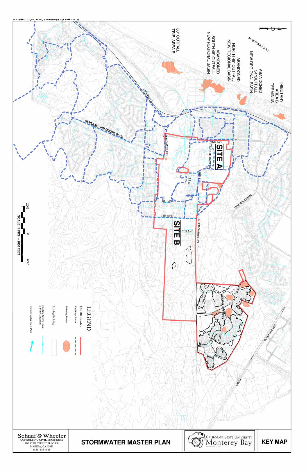
CS
UM
B B
oundary
Existing Storm
Drain
Existing B
asins
Drainage B
asin
LE
GE
ND
Surface W
ater Flow
Path
Existing B
uilding
& F
low D
irection
MONTEREY BAYA
BA
ND
ON
ED
54"O
UT
FA
LLN
EW
RE
GIO
NA
L BA
SIN
AB
AN
DO
NE
D
NO
RT
H 48" O
UT
FA
LLN
EW
RE
GIO
NA
L BA
SIN
AB
AN
DO
NE
D
SO
UT
H 48" O
UT
FA
LLN
EW
RE
GIO
NA
L BA
SIN
60" OU
TF
ALL
TR
IB. A
RE
A E
LIG
HT
FI G
HT
ER
DR
.2ND AVE.
6TH AVE.
7TH AVE.
8TH AVE.
1S
T S
T.
3R
D S
T.
INT
ER
-GA
RR
ISO
N R
D.
IMJIN PARKWAY
NO
RT
H C
AM
PU
S
CS
UM
B H
OU
SI N
G
HIG
HW
AY 1
RE
SER
VA
TION
RO
AD
TR
IBU
TA
RY
A
RE
A B
TE
RM
INU
S
STORMWATER MASTER PLAN KEY MAP
SC
AL
E: 1 IN
CH
= 2000 FEE
T
100 12TH STREET BLD 2900MARINA, CA 93933
(831) 883-4848
SIT
E A
SIT
E B

VA
RIE
S
2-ft. 1
-ft. FR
EE
BO
AR
D,
TY
PIC
AL
SLO
PE
PR
OT
EC
TIO
N(T
YP
ICA
L)
RIP
RA
PP
RO
TE
CT
ION
ST
OR
M D
RA
IN

EX
ISTING
DISC
HA
RG
E
TO O
PEN
SPAC
E
BATCH PLANT
0.5
0 A
CR
ES
N.C
.F.
0.2
0 A
CR
ES
0.4
0 A
CR
ES
0.5
0 A
CR
ES
REMOVE BU
ILDING &
PARKING LOT
LOCAL DEPRESSED
AREA
CULVERT
REMO
VE ASPHALT
EXPAND EXISTING
BASIN
REMOVE
ASPHALT
CU
LV
ER
TC
UL
VE
RT
CO
NC
RE
TE
SW
ALE
CONCRETE SWALES
ON
TOP OF BANK
CU
LV
ER
T
0.7
0 A
CR
ES
CU
LV
ER
T
0.4
0 A
CR
ES
ABANDON
EXISTINGO
UTFALL & REM
OVE CONCRETE SW
ALE
REMO
VE BUILDINGS &
PARKING LOT
DRIVEWAY
SWALEDRIVEWAY
SWALE
DRIVEWAY
SWALE
0300
FEE
T

CCSSUUMMBB EEXXHHIIBBIITT CC
Cost Estimate Table Proposal Title: Monterey Peninsula, Carmel Bay, and South Monterey Bay
Integrated Regional Water Management Plan and Integrated Coastal Watershed Management Plan
Project Title: Storm Water Percolation and Education Project
Budget Category Non-State Share(Funding Match)
Requested State Share
(Grant Funding) Total
(a) Direct Project Administration Costs 5500,,000000 5522,,000000 110022,,000000
(b) Land Purchase/Easement -------------------------------------- -------------------------------------- --------------------------
(c) Planning/Design/Engineering/Environmental Documentation
-------------------------------------- 117755,,000000 117755,,000000
(d) Construction/Implementation 110000,,000000 22,,551199,,000000 22,,661199,,000000
(e) Environmental Compliance/Mitigation/Enhancement -------------------------------------- 117766,,220000 117766,,000000
(f) Project Summary [Sum (a) through (e) for each column] 115500,,000000 22,,992222,,220000 33,,007722,,220000
(g) Construction Administration 5500,,000000 115511,,990000 220011,,990000
(h) Other (Explain): _______________________________ -------------------------------------- -------------------------------------- ------------------------
(i) Construction/Implementation Contingency 115522,,660000 9999,,330000 225511,,990000
(j) Grant Total [Sum (f) through (i) for each column] 335522,,660000 33,,117733,,440000 33,,552266,,000000
Source(s) of funds for Non-State Share (Funding Match) CSUMB facilities budget and campus planning in-kind services.

Big Sur Land Trust Integrated Regional Water Management Projects
Table of Contents Project Descriptions 1Financing 18Project Schedules 28Water Management Strategies 32Relation to Local Planning 36Relation to Statewide Priorities 38Consistency with Regional Objectives and Regional Priorities 43Impacts and Benefits 45Technical Analysis 47Stakeholder Involvement 48Data Management 50Project Locations 54

1
Monterey Peninsula, Carmel Bay, and South Monterey Bay Integrated Regional Water Management Plan and Integrated Coastal Watershed Management Plan
Big Sur Land Trust
PROJECT TITLE: Watershed and Water Supply Protection Through Use of Conservation Easements PROJECT DESCRIPTION: Big Sur Land Trust (BSLT) and The Nature Conservancy (TNC) will develop a conservation easement to protect privately owned Carmel River Watershed lands and negotiate and execute an agreement with a willing landowner. The easement will apply to a top priority ranch or other significant private property. The conservation easement terms will be developed by TNC ecologists working in partnership with BSLT and partner organizations, potentially including the Regional Water Quality Control Board and Department of Fish and Game, to ensure a high level of protection for surface and ground water resources. PROJECT DIRECTOR: Bill Leahy, BSLT Executive Director 831-625-5523 GRANT FUNDS REQUESTED: $5,000,000 LOCAL COST MATCH: $5,000,000 TOTAL BUDGET: $10,000,000 PROJECT GOAL AND BENEFITS: This project will demonstrate best management practices for protecting privately owned Carmel River Watershed lands through negotiation and implementation of a model conservation easement with a willing private property owner. The conservation easement will ensure a high level of land stewardship leading to decreased erosion and sedimentation, curtailment from other land use impacts, and water management. This project will also eliminate the threat of potential future impacts associated with water development, residential subdivisions, high-intensity agricultural production, and other watershed build-out. The conservation easement will provide for continued livestock grazing using best management practices, as well as other compatible personal and economic uses by the landowner(s). This project will simultaneously ensure downstream protection of water supply, water quality, and wildlife habitat. This conservation easement will be drafted to provide a powerful example for other conservation easements in the watershed, and may serve to encourage other landowners to take advantage of opportunities to engage in conservation easement projects in the future. In addition, this project will stimulate new sources of funding from private and public sources to provide incentives to landowners to consider implementing land and water conservation in the watershed.

2
SCHEDULE: January 1, 2007: Property identified January 1, 2007: Easement agreement negotiated and easement purchase agreement completed. November 2007: Execute purchase agreement. COORDINATES: N 36° 30' 40.78'' N; 121° 47' 9.46'' W WATERSHED: Carmel River Watershed and/or San Jose Creek COUNTY: Monterey COOPERATING ENTITIES:
The Nature Conservancy The Big Sur Land Trust Willing Private Property owner to be identified Other possible partners would include USDA – NRCS, California DFG and the
Regional Water Quality Control Board PROJECT CATEGORY: environmental habitat protection and improvement, water supply reliability, water quality protection and improvement, NPS pollution control PROJECT STATUS: TNC & BSLT are in preliminary conversations with several prospective landowners.
3
Monterey Peninsula, Carmel Bay, and South Monterey Bay Integrated Regional Water Management Plan and Integrated Coastal Watershed Management Plan
Big Sur Land Trust
PROJECT TITLE: Carmel River Parkway Trails, Restoration, and Education PROJECT DESCRIPTION: This project will increase parkland access and restore riparian and wetland habitat at the mouth of the Carmel River. A Carmel River Parkway Community Vision Plan is currently being developed and from this phase I of the Carmel River Parkway Plan will be released. Phase II consists of further planning for land owner agreements, technical design and engineering for trails and bridges, impact reports, permits, funding agreements, community awareness, and assessment of implementation. Phase III will consist of implementation and construction of improvements. The Parkway Planning involves three project components: trails, restoration, and education. Existing parklands will be connected through a series of approximately ten new trails providing increased public access. Riparian and wetland restoration will be conducted. An assessment and potential restoration of oak woodland, redwood forests, and Monterey pine forests will also be performed. An education site will be established including learning, interpretation, and visitor services to inform the public of the rich diversity in the Carmel River Watershed. PROJECT DIRECTOR: Bill Leahy, BSLT Executive Director 831-625-5523 Day to Day Contact: Cynthia Holmsky, BSLT 831-625-5523 GRANT FUNDS REQUESTED: $2,000,000 LOCAL COST MATCH: $208,000 TOTAL BUDGET: $$2,208,000 PROJECT GOAL AND BENEFITS: Restore lower reaches of Carmel River and cultivate awareness and commitment to land and water conservation through access, demonstration, and education. SCHEDULE: Feb 2006: Landowner agreements June 2006: Design plans Sept 2006: Impact reports Dec 2006: Permits September 2007: Begin restoration efforts

4
June 2008: Begin trail construction June 2008: Begin education outreach and interpretation efforts COORDINATES: N 36° 32' 9.25; W 121° 54' 40.2'' W WATERSHED: Carmel River COUNTY: Monterey COOPERATING ENTITIES: Partnerships and agreements will be formed with key landowners, including:
Three park agencies California State Parks Monterey County Parks Monterey Peninsula Regional Park District
Private land owners / business owners
Expertise, community support and resources will be shared with a number of organizations, including:
Department of Fish and Game California State University Monterey Bay (Watershed Institute, Return of the
Natives) RisingLeaf Watershed Arts Carmel Unified School District Carmel River Steelhead Association Audubon Society Monterey County Agriculture and Historical Land Conservancy
PROJECT CATEGORY: ecosystem restoration, environmental habitat protection and improvement, recreation and public access, water conservation, water quality protection and improvement, wetlands enhancement and creation, watershed planning PROJECT STATUS: Phase I, the Community Based Vision Plan is anticipated for release in July 2005.

5
Monterey Peninsula, Carmel Bay, and South Monterey Bay Integrated Regional Water Management Plan and Integrated Coastal Watershed Management Plan
Big Sur Land Trust
PROJECT TITLE: Restoration of the Carmel River Floodplain PROJECT DESCRIPTION: An initial engineering and biological assessment and hydrogeomorphological study will be conducted to determine the best means of restoring the historic flood plain at Garland Ranch Regional Park to improve riparian habitat, floodway capacity, and endangered species viability. Channel engineering, environmental and community benefits and impacts, design specifications, and costs will be determined. The initial engineering and biological assessments will determine subsequent implementation options and collaborative multi-party implementation funding strategies. Final engineering and design of recommended actions will also be conducted.
PROJECT DIRECTOR: Bill Leahy, BSLT Executive Director 831-625-5523 Day to day Contact: Tim Jensen, Monterey Peninsula Regional Park District 831-372-3196 GRANT FUNDS REQUESTED: $350,000 LOCAL COST MATCH: $60,000 TOTAL BUDGET: $410,000 PROJECT GOAL AND BENEFITS: The goal of this project is to determine the feasibility of restoring the historic floodplain at Garland Ranch Regional Park to improve riparian habitat, floodway capacity, and endangered species (California red-legged frog and tiger salamander) viability. Restoration of the floodway has been identified in inter-agency watershed planning discussions between the Monterey Peninsula Water Management District and Monterey Peninsula Regional Park District as a valuable project that benefits both agency’s missions and stewardship responsibilities. The historic floodway shows physical evidence of former river channels that flooded in 1995 and the current river channel has been down-cut for decades due to upstream dam regulation of the river. As a result, floodway riparian habitat has steadily declined from lack of regular flooding.
SCHEDULE: • August 2007 – Develop scope of work and begin bid solicitation • October 2007 – Issue Notice to Proceed to contractor • December 2008 – Complete project

6
COORDINATES: N 36° 29' 24"N, W 121° 46' 10" WATERSHED: Carmel River (3500-acres Garland Ranch Regional Park)
COUNTY: Monterey COOPERATING ENTITIES:
• National Fish & Wildlife Service • State Fish & Game Department • Monterey County (Water Resources Agency, Public Works Department,
Emergency Services) • California-American Water Company • Carmel River Watershed Conservancy • Carmel Valley Property Owners Association
PROJECT CATEGORY: ecosystem restoration, environmental habitat protection and improvement, flood management, wetlands enhancement and creation
PROJECT STATUS: initial agency planning stage

7
Monterey Peninsula, Carmel Bay, and South Monterey Bay Integrated Regional Water Management Plan and Integrated Coastal Watershed Management Plan
Big Sur Land Trust
PROJECT TITLE: Restore Roads with Sedimentation Problems in Regional Parks
PROJECT DESCRIPTION: An initial engineering and biological assessment and hydrologic engineering study will be conducted to determine the best means of restoring roads with sedimentation problems in Carmel River Valley regional parks. This study will determine physical design options, environmental and community benefits and impacts, design specifications, and costs to restoring these roads. The initial engineering and biological assessments will quantify erosion, transport, sedimentation, and stream loading while determining subsequent implementation options and collaborative multi-party implementation funding strategies. This project will also consist of final engineering and design of recommended actions.
PROJECT DIRECTOR: Bill Leahy, BSLT Executive Director 831-625-5523 Day to day Contact: Tim Jensen, Monterey Peninsula Regional Park District 831-372-3196 GRANT FUNDS REQUESTED: $200,000 LOCAL COST MATCH: $20,000 TOTAL BUDGET: $220,000 PROJECT GOAL AND BENEFITS: The goal of this project is to determine the feasibility of design and restoration of former ranch roads in three large Carmel River Watershed regional parks. Restoration efforts will reduce soil erosion and subsequent sediment transport and load into the Carmel River. Reduction in sedimentation will improve habitat for steelhead, red legged frogs, and other aquatic wildlife dependent upon clean water. New engineering designs will improve public safety access, recreational access, and ongoing maintenance demand. Design and restoration is a best management practice to correct previous ill-designed and inappropriate road construction and protect public environmental trust values via improved road/trail designs.
SCHEDULE: • August 2007 – Develop scope of work and begin bid solicitation • October 2007 – Issue Notice to Proceed to contractor • December 2008 – Complete project

8
COORDINATES:
N 36° 25' 32", 121° 42' 04" W N 36° 23' 37"N, 121° 40' 49" W N 36° 29' 24", 121° 46' 10" W (3500-acres Garland Ranch Regional Park, Carmel River Watershed) N36° 31' 42", 121° 53' 57"W (4500-acres Palo Corona Regional Park, Carmel River Watershed) WATERSHED: Carmel River COUNTY: Monterey COOPERATING ENTITIES: National Marine Fisheries Service National Fish & Wildlife Service State Fish & Game Department Monterey County (Water Resources, Public Works Department, Emergency
Services) California Fire Safe Council California-American Water Company Carmel River Watershed Conservancy Salmonid Restoration Federation Carmel River Steelhead Association
PROJECT CATEGORY: environmental habitat protection and improvement, water supply reliability, recreation and public access, water quality protection and improvement, NPS pollution control
PROJECT STATUS: initial agency planning stage

9
Monterey Peninsula, Carmel Bay, and South Monterey Bay Integrated Regional Water Management Plan and Integrated Coastal Watershed Management Plan
Big Sur Land Trust
PROJECT TITLE: Farm Water Conservation and Best Management Practices PROJECT DESCRIPTION: BSLT will collaborate with a farm lessee to manage the Odello East property to protect water quality, reduce water use, manage runoff, eradicate noxious weeds, and preserve riparian habitat adjacent to farmland property. BSLT is seeking an organic farm lessee who will use best management practices as identified by NRCS and RCD staff, who will use less water-intensive irrigation methods (e.g. drip irrigation), and who will include native habitat buffers around the farm. State Parks will convert approximately 11 acres of its land on the west side of Highway 1 (Odello West) to agricultural use with the same farm lessee, with the goal of interpreting the agricultural history of the Odello farms for the public. PROJECT DIRECTOR: Bill Leahy, BSLT Executive Director 831-625-5523 Day to Day Contact: Susanna Danner, BSLT 831-625-4027 GRANT FUNDS REQUESTED: $50,000 LOCAL COST MATCH: $10,000 TOTAL BUDGET: $60,000 PROJECT GOAL AND BENEFITS: The goal of this project is to implement a farming demonstration project at the mouth of the Carmel River that emphasizes best management practices, water conservation, agricultural runoff retention, and riparian habitat protection. The Big Sur Land Trust owns eighty acres of fee and easement lands adjacent to the Carmel River, a property known as Coast Ranch or Odello East. These lands are restricted with agricultural easements by BSLT and the Monterey County Agricultural and Historical Land Conservancy. Historically, this land was farmed in conventional artichokes; more recently, it has been organically farmed in spinach, chard, and kale. The property is currently fallow, having been used for fill disposal as part of the Carmel River Lagoon restoration project conducted by State Parks. Topsoil on the property was preserved and restored over the farm acreage after fill placement by State Parks.
10
SCHEDULE: August 2007: Participating farmer/s identified August 2007: Demonstration farm lease developed November 2007: Removal of noxious weeds November 2006- November 2007: Installation of best management practices (vegetated swales, buffer strips, drip irrigation, etc.) November 2007- October 2009: Monitoring and adaptive management COORDINATES: 36˚ 31’ 58.87” N; 121˚ 54’ 27.64” W WATERSHED: Carmel River COUNTY: Monterey COOPERATING ENTITIES:
The Big Sur Land Trust California State Parks Private farmer/s RCD/NRCS UC Cooperative Extension
PROJECT CATEGORY: Watershed Protection and Planning, Water Supply Reliability, Clean Water, Water Conservation PROJECT STATUS: Planning

11
Monterey Peninsula, Carmel Bay, and South Monterey Bay Integrated Regional Water Management Plan and Integrated Coastal Watershed Management Plan
Big Sur Land Trust
PROJECT TITLE: Uplands Grazing Management and Monitoring for Sediment Reduction and Habitat Protection PROJECT DESCRIPTION: Phase II of a grazing management plan will be developed for the Palo Corona Ranch landscape which emphasizes adaptive management with applications to sediment reduction and habitat protection. Plan recommendations will be implemented in addition to fencing installation on the project site. Residual dry matter monitoring, vegetation monitoring, and water quality monitoring will be conducted when planning is complete. This project also consists of a built in public outreach component as it includes development of a public interpretation program and posted signage on the project site. This project seeks to produce a grazing monitoring plan that will provide data that are scientifically defensible and will be used to adaptively guide and refine management goals using grazing as a tool. Recommendations will be made for improvements to dirt roads to reduce sediment pollution into Carmel River and/or San Jose Creek. An assessment of the impacts of existing infrastructure (e.g. roads, pasture configurations, water sources) on various components of watershed health will be completed. This plan will identify habitat management goals for each pasture, including plans for riparian protection and infrastructure improvements (e.g. riparian fencing, pond management) in addition to grazing prescriptions that will achieve management goals of minimizing impacts to water quality and sensitive aquatic habitats. This plan will result in a research plan that outlines the outstanding scientific questions that need to be addressed to adequately manage uplands with grazing at Palo Corona Ranch. PROJECT DIRECTOR: Bill Leahy, BSLT Executive Director 831-625-5523 Day to day Contact: Susanna Danner, BSLT 831-625-4027 GRANT FUNDS REQUESTED: $750,000 LOCAL COST MATCH: $400,000 TOTAL BUDGET: $1,150,000 PROJECT GOAL AND BENEFITS: To manage cattle grazing in ways that promote healthy watersheds. SCHEDULE:
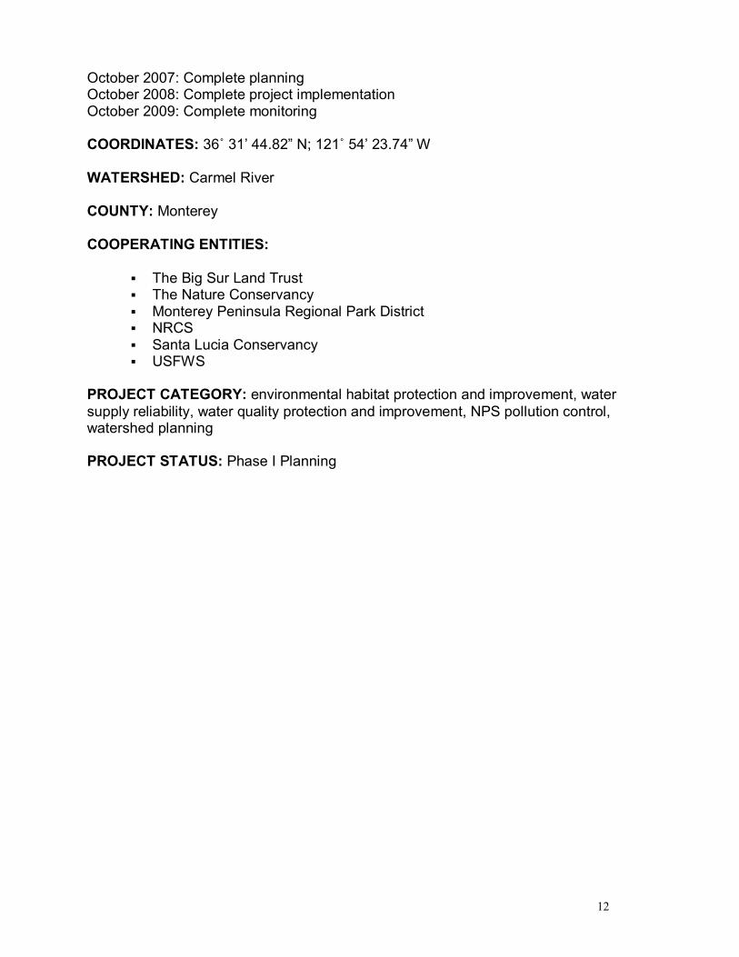
12
October 2007: Complete planning October 2008: Complete project implementation October 2009: Complete monitoring COORDINATES: 36˚ 31’ 44.82” N; 121˚ 54’ 23.74” W WATERSHED: Carmel River COUNTY: Monterey COOPERATING ENTITIES:
The Big Sur Land Trust The Nature Conservancy Monterey Peninsula Regional Park District NRCS Santa Lucia Conservancy USFWS
PROJECT CATEGORY: environmental habitat protection and improvement, water supply reliability, water quality protection and improvement, NPS pollution control, watershed planning PROJECT STATUS: Phase I Planning

13
Monterey Peninsula, Carmel Bay, and South Monterey Bay Integrated Regional Water Management Plan and Integrated Coastal Watershed Management Plan
Big Sur Land Trust
PROJECT TITLE: Removal of Del Monte Resort Dam PROJECT DESCRIPTION: An initial site report and study will be conducted to determine the best means of removing the Del Monte Resort Dam, restoration needs and costs, and upstream and downstream impacts and benefits. This project will include a preliminary engineering review. Based on these results, Big Sur Land Trust and project partners will seek funding from a variety of sources to implement the project. PROJECT DIRECTOR: Bill Leahy, BSLT Executive Director 831-625-5523 GRANT FUNDS REQUESTED: $300,000 LOCAL COST MATCH: $5,000 TOTAL BUDGET: $305,000 PROJECT GOAL AND BENEFITS: The goal of this project is to determine the best means and cost of removing the Del Monte Resort Dam and restoring the area to improve fish passage and aquatic and terrestrial habitats. Removal of the dam and restoration of the site downstream is recommended in the Carmel River Watershed Council Restoration Action Plan and endorsed by NOAA Fisheries and the Monterey Peninsula Water Management District. This dam is a partial barrier to steelhead trout migration. Removal will improve habitat for steelhead, red-legged frogs, and other terrestrial and aquatic species in addition to allowing fish passage at a wider range of flows and with a decreased chance of injury to listed species. SCHEDULE: August 2007: Develop scope of work and begin bid solicitation process October 2007: Issue Notice to Proceed to contractor December 2008: Complete project COORDINATES: 36˚27’55.76” N; 121˚42’50.35” W WATERSHED: Carmel River COUNTY: Monterey

14
COOPERATING ENTITIES: NOAA Fisheries Cal Am Water Department of Fish and Game Monterey Peninsula Water Management District Carmel River Watershed Council
PROJECT CATEGORY: ecosystem restoration, environmental habitat protection and improvement PROJECT STATUS: initial planning stages

15
Monterey Peninsula, Carmel Bay, and South Monterey Bay Integrated Regional Water Management Plan and Integrated Coastal Watershed Management Plan
Big Sur Land Trust
PROJECT TITLE: Restoration of Hatton Creek
PROJECT DESCRIPTION: An initial assessment and hydrogeomorphological study will be conducted to determine the best means of restoring the historic Hatton Creek at Hatton Canyon State Park to improve riparian habitat, re-establish/connect the wildlife corridor, and provide expanded endangered species habitat. Channel engineering, environmental and community benefits and impacts, design specifications, and costs will be determined. This project will include an initial engineering and biological assessment that will determine subsequent implementation options and collaborative multi-party implementation funding strategies. This project will also consist of final engineering and design of recommended actions. PROJECT DIRECTOR: Bill Leahy, BSLT Executive Director 831-625-5523 Day to day Contact: Tim Jensen, Monterey Peninsula Regional Park District 831-372-3196 GRANT FUNDS REQUESTED: $200,000 LOCAL COST MATCH: $40,000 TOTAL BUDGET: $240,000 PROJECT GOAL AND BENEFITS: The goal of this project is to determine the best means of restoring the historic Hatton Creek at Hatton Canyon State Park to improve riparian habitat, re-establish/connect the wildlife corridor, and provide expanded endangered species (California red-legged frog and tiger salamander) habitat. This project also seeks to create a public greenbelt and passive recreational open space that currently has overburden material, weeds and exotic plants, and graded and compacted landscape. The Monterey Peninsula Regional Park District, State Parks, and area businesses and environmental groups have identified restoration of the creek as a valuable project that benefits the environment and the community in informal discussions and formal initial planning studies. The property is in the process of being transferred from State Parks to the Monterey Peninsula Regional Park District.
SCHEDULE:
• August 2007 – Develop Scope of Work and begin bid solicitation • October 2007 – Issue Notice to Proceed to contractor
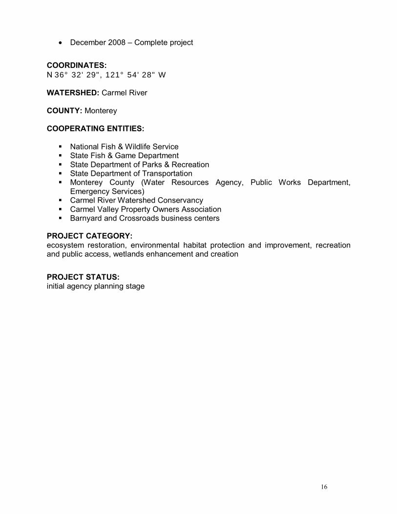
16
• December 2008 – Complete project
COORDINATES: N 36° 32' 29", 121° 54' 28" W WATERSHED: Carmel River COUNTY: Monterey COOPERATING ENTITIES: National Fish & Wildlife Service State Fish & Game Department State Department of Parks & Recreation State Department of Transportation Monterey County (Water Resources Agency, Public Works Department,
Emergency Services) Carmel River Watershed Conservancy Carmel Valley Property Owners Association Barnyard and Crossroads business centers
PROJECT CATEGORY: ecosystem restoration, environmental habitat protection and improvement, recreation and public access, wetlands enhancement and creation
PROJECT STATUS: initial agency planning stage

17
Monterey Peninsula, Carmel Bay, and South Monterey Bay Integrated Regional Water Management Plan and Integrated Coastal Watershed Management Plan
Big Sur Land Trust
PROJECT TITLE: Project Monitoring PROJECT DESCRIPTION: Project monitoring will be conducted to determine overall effectiveness of project implementation as it relates to water management and integration strategies. This project will help define and implement the Project Assessment and Evaluation Plan for projects put forward for grant funding. PROJECT DIRECTOR: Bill Leahy, BSLT Executive Director 831-625-5523 GRANT FUNDS REQUESTED: $150,000 LOCAL COST MATCH: $15,000 TOTAL BUDGET: $165,000 PROJECT GOAL AND BENEFITS: Measuring and understanding the effects of management strategies as they are implemented is key to evaluating the success of the overall effort. SCHEDULE: July 2007 – November 2009: Monitor project effectiveness COORDINATES: N 36° 29' 0.39"; W 121° 48' 20.68" WATERSHED: Carmel River COUNTY: Monterey COOPERATING ENTITIES:
MBNMS Citizen Monitoring
PROJECT CATEGORY: ecosystem restoration, environmental habitat protection and improvement, water supply reliability, flood management, recreation and public access, water conservation, water quality protection and improvement, wetlands enhancement and creation, NPS pollution control, watershed planning PROJECT STATUS: agency planning

18
Big Sur Land Trust Monterey Bay, Carmel Bay, and South Monterey Bay
Integrated Regional Water Management Plan
Financing Ongoing operations and maintenance of the following projects will be funded by private contributions to Big Sur Land Trust and The Nature Conservancy: Watershed and Water Supply Protection Through Use of Conservation Easements Carmel River Parkway Trails, Restoration, and Education Farm Water Conservation and Best Management Practices Uplands Grazing Management and Monitoring for Sediment Reduction and Habitat Protection Restore Roads with Sedimentation Problems in Regional Parks The following projects do not require long term maintenance funding: Restoration of the Carmel River Floodplain Removal of Del Monte Resort Dam Restoration of Hatton Creek Project Monitoring Refer to the budget sheets below for more detailed budgets on each individual project.

19
Big Sur Land Trust Monterey Peninsula, Carmel Bay, and South Monterey Bay
Integrated Regional Water Management Plan Implementation Budget
Cost Estimate Sheet Project Title: Watershed and Water Supply Protection Through Use of Conservation Easements Budget Category Non-state Share
(Funding Match) State Share (Grant Funding) Total
(a) Direct Project Administration Costs $75,000 $75,000
(b) Land Purchase/Easement $4,000,000 $4,475,000 $8,475,000
(c) Planning/Design/Engineering/Environmental Documentation
$500,000 $100,000 $600,000
(d) Construction/Implementation
(e) Environmental Compliance/Mitigation/Enhancement $350,000 $350,000
(f) Project Summary [Sum (a) through (e) for each column] $900,000 $5,000,000 $9,500,000
(g) Construction Administration
(h) Other Legal costs and security fees
$500,000 $500,000
(i) Construction/Implementation Contingency
(j) Grant Total [Sum (f) through (i) for each column] $5,000,000 $5,000,000 $10,000,000
Source of funds for Non-State Share (Funding Match)

20
Big Sur Land Trust Monterey Peninsula, Carmel Bay, and South Monterey Bay
Integrated Regional Water Management Plan Implementation Budget
Cost Estimate Sheet Project Title: Carmel River Parkway Trails, Restoration, and Education Budget Category Non-state Share
(Funding Match) State Share (Grant Funding) Total
(a) Direct Project Administration Costs $96,000 $150,000 $246,000
(b) Land Purchase/Easement
(c) Planning/Design/Engineering/Environmental Documentation
$112,000 $400,000 $512,000
(d) Construction/Implementation $1,250,000 $1,250,000
(e) Environmental Compliance/Mitigation/Enhancement $100,000 $100,000
(f) Project Summary [Sum (a) through (e) for each column] $208,000 $1,900,000 $2,108,000
(g) Construction Administration $100,000 $100,000
(h) Other
(i) Construction/Implementation Contingency
(j) Grant Total [Sum (f) through (i) for each column] $208,000 $2,000,000 $2,208,000
Source of funds for Non-State Share (Funding Match)

21
Big Sur Land Trust
Monterey Peninsula, Carmel Bay, and South Monterey Bay Integrated Regional Water Management Plan
Implementation Budget
Cost Estimate Sheet Project Title: Restoration of the Carmel River Floodplain Budget Category Non-state Share
(Funding Match) State Share (Grant Funding) Total
(a) Direct Project Administration Costs $28,000 $28,000
(b) Land Purchase/Easement
(c) Planning/Design/Engineering/Environmental Documentation
$60,000 $322,000 $382,000
(d) Construction/Implementation
(e) Environmental Compliance/Mitigation/Enhancement
(f) Project Summary [Sum (a) through (e) for each column] $60,000 $350,000 $410,000
(g) Construction Administration
(h) Other
(i) Construction/Implementation Contingency
(j) Grant Total [Sum (f) through (i) for each column] $60,000 $350,000 $410,000
Source of funds for Non-State Share (Funding Match)

22
Big Sur Land Trust
Monterey Peninsula, Carmel Bay, and South Monterey Bay Integrated Regional Water Management Plan
Implementation Budget
Cost Estimate Sheet Project Title: Restore Roads with Sedimentation Problems in Regional Parks Budget Category Non-state Share
(Funding Match) State Share (Grant Funding) Total
(a) Direct Project Administration Costs $16,000 $16,000
(b) Land Purchase/Easement
(c) Planning/Design/Engineering/Environmental Documentation
$20,000 $184,000 $204,000
(d) Construction/Implementation
(e) Environmental Compliance/Mitigation/Enhancement
(f) Project Summary [Sum (a) through (e) for each column] $20,000 $200,000 $220,000
(g) Construction Administration
(h) Other
(i) Construction/Implementation Contingency
(j) Grant Total [Sum (f) through (i) for each column] $20,000 $200,000 $220,000
Source of funds for Non-State Share (Funding Match)

23
Big Sur Land Trust Monterey Peninsula, Carmel Bay, and South Monterey Bay
Integrated Regional Water Management Plan Implementation Budget
Cost Estimate Sheet Project Title: Farm Water Conservation and Best Management Practices Budget Category Non-state Share
(Funding Match) State Share (Grant Funding) Total
(a) Direct Project Administration Costs $10,000 $10,000
(b) Land Purchase/Easement
(c) Planning/Design/Engineering/Environmental Documentation
$47,000 $47,000
(d) Construction/Implementation
(e) Environmental Compliance/Mitigation/Enhancement
(f) Project Summary [Sum (a) through (e) for each column] $10,000 $47,000 $57,000
(g) Construction Administration
(h) Other monitoring
$3,000 $3,000
(i) Construction/Implementation Contingency
(j) Grant Total [Sum (f) through (i) for each column] $10,00 $50,000 $60,000
Source of funds for Non-State Share (Funding Match)

24
Big Sur Land Trust Monterey Peninsula, Carmel Bay, and South Monterey Bay
Integrated Regional Water Management Plan Implementation Budget
Cost Estimate Sheet Project Title: Uplands Grazing Management and Monitoring for Sedimentation Reduction and Habitat Protection Budget Category Non-state Share
(Funding Match) State Share (Grant Funding) Total
(a) Direct Project Administration Costs $50,000 $60,000 $110,000
(b) Land Purchase/Easement
(c) Planning/Design/Engineering/Environmental Documentation
$50,000 $200,000 $250,000
(d) Construction/Implementation $300,000 $375,000 675,000
(e) Environmental Compliance/Mitigation/Enhancement
(f) Project Summary [Sum (a) through (e) for each column] $400,000 $635,000 $1,035,000
(g) Construction Administration
(h) Other monitoring
$115,000 $115,000
(i) Construction/Implementation Contingency
(j) Grant Total [Sum (f) through (i) for each column] $400,000 $750,000 $1,150,000
Source of funds for Non-State Share (Funding Match)

25
Big Sur Land Trust Monterey Peninsula, Carmel Bay, and South Monterey Bay
Integrated Regional Water Management Plan Implementation Budget
Cost Estimate Sheet Project Title: Removal of Del Monte Resort Dam Budget Category Non-state Share
(Funding Match) State Share (Grant Funding) Total
(a) Direct Project Administration Costs $24,000 $24,000
(b) Land Purchase/Easement
(c) Planning/Design/Engineering/Environmental Documentation
$5,000 $276,000 $281,000
(d) Construction/Implementation
(e) Environmental Compliance/Mitigation/Enhancement
(f) Project Summary [Sum (a) through (e) for each column] $5,000 $300,000 $305,000
(g) Construction Administration
(h) Other
(i) Construction/Implementation Contingency
(j) Grant Total [Sum (f) through (i) for each column] $5,000 $300,000 $305,000
Source of funds for Non-State Share (Funding Match)

26
Big Sur Land Trust Monterey Peninsula, Carmel Bay, and South Monterey Bay
Integrated Regional Water Management Plan Implementation Budget
Cost Estimate Sheet Project Title: Restoration of Hatton Creek Budget Category Non-state Share
(Funding Match) State Share (Grant Funding) Total
(a) Direct Project Administration Costs $16,000 $16,000
(b) Land Purchase/Easement
(c) Planning/Design/Engineering/Environmental Documentation
$40,000 $184,000 $224,000
(d) Construction/Implementation
(e) Environmental Compliance/Mitigation/Enhancement
(f) Project Summary [Sum (a) through (e) for each column] $40,000 $200,000 $240,000
(g) Construction Administration
(h) Other
(i) Construction/Implementation Contingency
(j) Grant Total [Sum (f) through (i) for each column] $40,000 $200,000 $240,000
Source of funds for Non-State Share (Funding Match)

27
Big Sur Land Trust
Monterey Peninsula, Carmel Bay, and South Monterey Bay Integrated Regional Water Management Plan
Implementation Budget
Cost Estimate Sheet Project Title: Project Monitoring Budget Category Non-state Share
(Funding Match) State Share (Grant Funding) Total
(a) Direct Project Administration Costs $1,200 $1,200
(b) Land Purchase/Easement
(c) Planning/Design/Engineering/Environmental Documentation
(d) Construction/Implementation $15,000 $148,800 $163,800
(e) Environmental Compliance/Mitigation/Enhancement
(f) Project Summary [Sum (a) through (e) for each column] $15,000 $150,000 $165,000
(g) Construction Administration
(h) Other
(i) Construction/Implementation Contingency
(j) Grant Total [Sum (f) through (i) for each column] $15,000 $150,000 $165,000
Source of funds for Non-State Share (Funding Match)

28
Big Sur Land Trust Monterey Peninsula, Carmel Bay, and South Monterey Bay
Integrated Regional Water Management Plan
Schedules Project Title: Watershed and Water Supply Protection Through Use of
Conservation Easements Entity Applying: Big Sur Land Trust Start Date: July 1, 2007 Completion Date: November 2007 List of Significant milestones and respective completion dates: Milestone Completion Date Acquisition of land, or rights of way (if required)
July 1, 2007
Property identified July 1, 2007 Easement agreement negotiated and easement purchase agreement completed
July 1, 2007
Execute purchase November 2007 Project Title: Carmel River Parkway Trails, Restoration, and Education Entity Applying: Big Sur Land Trust Start Date: June 2006 Completion Date: June 2008 List of Significant milestones and respective completion dates: Milestone Completion Date CEQA/NEPA preparation and completion December 2006 Project design and bid solicitation process June 2006 Construction start and end dates June 2008 Landowner agreements February 2006 Impact reports September 2006 restoration efforts October 2008 education outreach and interpretation efforts
November 2009

29
Project Title: Restoration of the Carmel River Floodplain Entity Applying: Big Sur Land Trust Start Date: August 2007 Completion Date: December 2008 List of Significant milestones and respective completion dates: Milestone Completion Date Project design and bid solicitation process August 2007 Issue Notice to Proceed to contractor October 2007 Complete project December 2008 Project Title: Restore Roads with Sedimentation Problems in Regional Parks Entity Applying: Big Sur Land Trust Start Date: August 2007 Completion Date: December 2008 List of Significant milestones and respective completion dates: Milestone Completion Date Project design and bid solicitation process August 2007 Issue Notice to Proceed to contractor October 2007 Complete project December 2008 Project Title: Farm Water Conservation and Best Management Practices Entity Applying: Big Sur Land Trust Start Date: August 2007 Completion Date: November 2007

30
List of Significant milestones and respective completion dates: Milestone Completion Date Participating farmers identified August 2007 Demonstration farm lease developed August 2007 Removal of noxious weeds November 2007 Installation of best management practices November 2007 Post implementation, construction, and monitoring efforts
November 2007
Project Title: Uplands Grazing Management and Monitoring for Sediment
Reduction and Habitat Protection Entity Applying: Big Sur Land Trust Start Date: October 2007, 2007 Completion Date: October 2009 List of Significant milestones and respective completion dates: Milestone Completion Date Post implementation, construction, and monitoring efforts
October 2009
Complete project implementation/construction
October 2008
Complete planning October 2007 Project Title: Removal of Del Monte Resort Dam Entity Applying: Big Sur Land Trust Start Date: August 2007 Completion Date: December 2008 List of Significant milestones and respective completion dates: Milestone Completion Date Project design and bid solicitation process August 2007 Issue Notice to Proceed to contractor
October 2007
Complete project December 2008

31
Project Title: Restoration of Hatton Creek Entity Applying: Big Sur Land Trust Start Date: August 2007 Completion Date: December 2008 List of Significant milestones and respective completion dates: Milestone Completion Date Project design and bid solicitation process August 2007 Issue Notice to Proceed to contractor October 2007 Complete project December 2008 Project Title: Project Monitoring Entity Applying: Big Sur Land Trust Start Date: July 1, 2007 Completion Date: November 2009 List of Significant milestones and respective completion dates: Milestone Completion Date Project effectiveness monitoring November 2009

32
Big Sur Land Trust Monterey Peninsula, Carmel Bay, and South Monterey Bay
Integrated Regional Water Management Plan
Water Management Strategies The projects identified by Big Sur Land Trust (BSLT) correspond to the water management strategies identified in the Integrated Regional Water Management Grant program guidelines. BSLT has identified nine projects to be incorporated in the Monterey Peninsula, Carmel Bay, and South Monterey Bay Integrated Regional Water Management Plan and integrated with other efforts in the watershed. These projects are outlined below and include: 1 conservation easement 2 watershed planning projects 3 restoration feasibility studies 1 dam removal project 1 water quality/water conservation management project 1 monitoring project Watershed and Water Supply Protection Through Use of Conservation Easements
Big Sur Land Trust (BSLT) and The Nature Conservancy (TNC) will develop and implement an innovative model conservation easement to protect privately owned Carmel River Watershed lands and negotiate and execute an agreement with a willing landowner. This high level of land stewardship will decrease erosion and sedimentation, curtail other land us impacts, and improve water management. Carmel River Parkway Trails, Restoration, and Education This project consists of site specific planning to increase public access to parklands and restore riparian and wetland habitats at the mouth of the Carmel River. Implementation and construction of improvements will be executed once planning in complete. Restoration of the Carmel River Floodplain Initial engineering studies and a biological assessment will be conducted to determine the best means of restoring the historic floodplain at Garland Ranch Regional Park to improve riparian habitat, floodway capacity, and endangered species viability. Final engineering and design of recommended actions will also be completed. Restore Roads with Sedimentation Problems in Regional Parks Initial engineering and biological assessment studies will be conducted to determine the best means of restoring roads with sedimentation problems in Carmel River Valley regional parks. Final engineering and design of recommended actions will also be completed. Farm Water Conservation and Best Management Practices BSLT will collaborate with a farm lessee to manage the Odello East property to protect water quality, reduce water use, manage runoff, eradicate noxious weeds, and preserve adjacent riparian habitat.

33
Uplands Grazing Management and Monitoring for Sediment Reduction and Habitat Protection A grazing management plan will be developed for the Palo Corona Ranch landscape which emphasizes adaptive management with applications to sediment reduction and habitat protection. Residual dry matter monitoring, vegetation monitoring, and water quality monitoring will be conducted when planning is complete. Removal of Del Monte Resort Dam An initial site report and study will be conducted to determine the best means of removing the Del Monte Resort Dam, restoration needs and costs, and upstream and downstream impacts and benefits. Final engineering and design of recommended actions will also be completed. Restoration of Hatton Creek An initial assessment and hydrogeomorphological study will be conducted to determine the best methods of restoring the historic Hatton Creek at Hatton Canyon State Park to improve riparian habitat, re-establish/connect the wildlife corridor, and provide expanded endangered species habitat. Final engineering and design of recommended actions will also be completed. Project Monitoring Project monitoring will be conducted to determine overall effectiveness of project implementation as it relates to water management and integration strategies. The projects are listed below by specific water management strategy. Ecosystem restoration
Carmel River Parkway Trails, Restoration, and Education Restoration of Carmel River Floodplain Del Monte Resort Dam Removal Restoration of Hatton Creek Project Monitoring
Environmental and habitat protection and improvement
Watershed and Water Supply Protection Through Use of Conservation Easements Carmel River Parkway Trails, Restoration, and Education Restoration of Carmel River Floodplain Restore Roads with Sedimentation Problems in Regional Parks Farm Water Conservation and Best Management Practices Uplands Grazing Management and Monitoring for Sediment Reduction and Habitat Protection Del Monte Resort Dam Removal Restoration of Hatton Creek Project Monitoring
Water supply reliability Watershed and Water Supply Protection Through Use of Conservation Easements Restore Roads with Sedimentation Problems in Regional Parks Farm Water Conservation and Best Management Practices Uplands Grazing Management and Monitoring for Sediment Reduction and Habitat Protection

34
Project Monitoring
Flood management Restoration of Carmel River Floodplain Watershed and Water Supply Protection Through Use of Conservation Easements Project Monitoring
Groundwater management
No BSLT projects involve groundwater management Recreation and public access
Carmel River Parkway Trails, Restoration, and Education Restore Roads with Sedimentation Problems in Regional Parks Restoration of Hatton Creek Project Monitoring
Storm water capture and management No BSLT projects involve stormwater capture and management
Water conservation
Carmel River Parkway Trails, Restoration, and Education Farm Water Conservation and Best Management Practices Project Monitoring
Water quality protection and improvement
Watershed and Water Supply Protection Through Use of Conservation Easements Carmel River Parkway Trails, Restoration, and Education Restore Roads with Sedimentation Problems in Regional Parks Farm Water Conservation and Best Management Practices Uplands Grazing Management and Monitoring for Sediment Reduction and Habitat Protection Project Monitoring
Water recycling
No BSLT projects involve water recycling Wetlands enhancement and creation
Carmel River Parkway Trails, Restoration, and Education Farm Water Conservation and Best Management Practices Restoration of Carmel River Floodplain Restoration of Hatton Creek Project Monitoring
Conjunctive use
No BSLT projects involve conjunctive use Desalination
No BSLT projects have applications to desalination
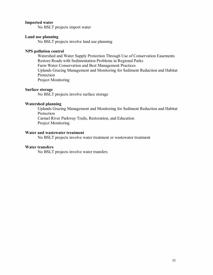
35
Imported water No BSLT projects import water
Land use planning
No BSLT projects involve land use planning NPS pollution control
Watershed and Water Supply Protection Through Use of Conservation Easements Restore Roads with Sedimentation Problems in Regional Parks Farm Water Conservation and Best Management Practices Uplands Grazing Management and Monitoring for Sediment Reduction and Habitat Protection Project Monitoring
Surface storage No BSLT projects involve surface storage
Watershed planning
Uplands Grazing Management and Monitoring for Sediment Reduction and Habitat Protection Carmel River Parkway Trails, Restoration, and Education Project Monitoring
Water and wastewater treatment
No BSLT projects involve water treatment or wastewater treatment Water transfers
No BSLT projects involve water transfers
36
Big Sur Land Trust Monterey Peninsula, Carmel Bay, and South Monterey Bay
Integrated Regional Water Management Plan
Relation to Local Planning Carmel River Watershed Assessment 2004 The most important issues identified by a public outreach process and included in the Carmel River Watershed Assessment are water quality, declining water quantity, declining riparian habitat for native species, erosion, excessive sediment transport, infiltration, runoff, and flooding/drainage. Big Sur Land Trust (BSLT) has identified nine projects that address these watershed issues. Of these projects, 3 directly relate to decreasing sedimentation, 3 will improve water quality in the Carmel River, 2 will reduce erosion, 6 will restore an/or improve riparian habitat, 3 will restore wetland habitat, 1 will reduce flood impacts, and 1 project will inclusively address all of these issues through project monitoring. The cumulative efforts of these projects will reduce non-point source inputs in the Carmel Bay Area of Special Biological Significance (ASBS). This Watershed Assessment recognized threatened species that inhabit the Carmel River Watershed. The current steelhead population is below historic numbers for the Carmel River and is well below populations found in Northern California coastal streams due in part to habitat fragmentation and degradation. In addition, the California red-legged frog is found in many areas of the watershed but not much is known about the population structure. All of Big Sur Land Trust’s projects support environmental and habitat protection and improvement. Three restoration projects will improve California red-legged frog habitat and tiger salamander habitat, also an endangered species. The Carmel River Parkway Trail, Restoration, and Education project also proposes to restore natural habitat at the mouth of the Carmel River. A project to remove the Del Monte Resort Dam will improve steelhead habitat by removing partial barriers, allowing fish passage at a wider range of flows and decreasing the chances of injury during passage. A watershed and water supply project using easements, a farm water conservation project, and a grazing management and monitoring project will also improve steelhead habitat by reducing sediment load into the Carmel River. Erosion, bank instability, and many other sediment contributors have been accelerated by land development for residential and agricultural purposes. The Watershed Assessment identified that proper landscaping and restoration of the riparian-wetland habitat could help to mitigate these impacts. Many projects proposed by BSLT address riparian and wetland restoration. The Carmel River Parkway Trails, Restoration, and Education project will restore natural riparian and wetland habitat at the mouth of the Carmel River. Restoration of the Carmel River Floodplain, Restoration of Hatton Creek, and the Farm Water Conservation and Best Management Practices project will also contribute to riparian habitat restoration and protection. Carmel River Action Plan 2004 Eight action categories were identified in the Carmel River Action Plan, which include: flows, groundwater, habitat, sedimentation, steelhead, education, public safety, and water quantity. 57 total actions were recommended and those that most closely coincide with the Big Sur Land

37
Trust projects are discussed here. Note that BSLT’s project to conduct overall project monitoring applies to all the recommendations below. Action Plan # CC-2 recommends the Carmel River Watershed Conservancy, in cooperation with appropriate local agencies, seek funding for watershed wide habitat restoration projects including permanent California red-legged frog habitat, restoration of riparian areas, and upland habitat. Integrated Regional Watershed Management Plan grant funding will support this action by providing financing for Big Sur Land Trust to execute restoration projects that will restore and protect sensitive habitat in the Carmel River Watershed. All of Big Sur Land Trust’s projects support environmental and habitat protection and improvement. Three restoration projects will improve California red-legged frog habitat and tiger salamander habitat. The Carmel River Parkway Trail, Restoration, and Education project also proposes to restore natural habitat at the mouth of the Carmel River. Removal of the Del Monte Resort Dam will improve steelhead habitat since it is a partial barrier to fish passage. In addition, implementation of a watershed and water supply protection project using easements, a farm water conservation, and a grazing management and monitoring project will improve steelhead habitat by reducing sediment load into Carmel River. Action plan # Hab-7 also calls to enhance habitat appropriate for the California red-legged frog along the main stem, as well as in tributary drainages and upland locations. Action Plan # Hab-9 encourages agricultural operation, golf courses, and commercial and private residences to use native grasses and riparian vegetation as a buffer to the main stem and tributaries. The Farm Water Conservation and Best Management Practice project will use best management practices, as identified by Natural Resource Conservation Service and Resource Conservation District staff, to use less water-intensive irrigation methods in addition to including native habitat buffers around the Odello East farm. Action Plan # Sed-6 calls for erosion prevention to reduce sediment deposition throughout the watershed including main tributaries and the main stem. Three of Big Sur Land Trust’s projects will have direct sediment reduction impacts in the watershed. The Watershed and Water Supply Protection Through Use of Conservation Easements project will decrease erosion and sedimentation thereby protecting the integrity of downstream water quality. A second project, Restore Roads with Sedimentation Problems in Regional Parks will reduce soil erosion and subsequent sedimentation through design and restoration of former ranch roads. Uplands Grazing Management and Monitoring for Sediment Reduction and Habitat Protection will reduce sediment input into the Carmel River through implementation of plan recommendations. These projects will reduce harmful amounts of sediment from entering waterways, while maintaining natural hydrology and geomorphology of streams by eliminating channelization and hardscaping. This will protect the integrity of water quality and natural habitat while maintaining the natural flow of sediment.
Action Plan # Pub-3 recommends development of a conservation education program for residents and landowners. Carmel River Parkway Trails, Restoration, and Education includes an education component of which the objective is to promote conservation of the overall watershed. A demonstration education site will be constructed to inform the public of the rich diversity in the Carmel River Watershed. This component will include learning, interpretation, and visitor services.

38
Big Sur Land Trust Monterey Peninsula, Carmel Bay, and South Monterey Bay
Integrated Regional Water Management Plan
Relation to Statewide Priorities Watershed Management Initiative (2002) Three of the priority activities identified in the 2002 Watershed Management Initiative parallel projects proposed by Big Sur Land Trust (BSLT). These priorities include expansion of nonpoint source pollution management efforts that address impacts of sedimentation, nutrients, and pesticides from agricultural activities and development of a riparian corridor protection policy. Big Sur Land Trust has proposed an Uplands Grazing Management and Monitoring project for Sedimentation Reduction and Habitat Protection that seeks to reduce sediment pollution in the Carmel River. Through this project, a grazing management plan will be developed for the Palo Corona Ranch landscape in the Carmel River Watershed. Recommendations will be made and implemented for road improvements and grazing prescriptions that will achieve management goals of minimizing impacts to water quality and sensitive aquatic habitats. All nine of BSLT’s projects support environmental habitat protection and improvement, with 4 projects emphasizing riparian habitat improvement. Carmel River Parkway Trails, Restoration, and Education consists of site specific planning to restore natural riparian habitat at the mouth of the Carmel River. Restoration of the Carmel River Floodplain and Restoration of Hatton Creek will improve riparian habitat by increasing vegetation through volunteer opportunities to plant natural flora, removing artificial channels, and reducing downstream flooding. A Farm Water Conservation and Best Management Practices project will preserve riparian habitat adjacent to the project farmland property and include native habitat buffers around the property. Watershed Management Initiative Update 2004 In September 2004 the Central Coast Watershed Management Initiative Update was released with an increased focus on agricultural water quality impacts. As previously mentioned, Uplands Grazing Management and Monitoring for Sedimentation Reduction and Habitat Protection will reduce sediment pollution in the Carmel River through recommendations for road improvements and grazing prescriptions on the Corona Ranch landscape. These efforts will achieve management goals of minimizing impacts to water quality and sensitive aquatic habitats in the Carmel River Watershed. Central Coast Regional Water Quality Control Board Basin Plan The main goal of the Central Coast Regional Water Quality Control Board is to ensure that the water resources of the Central Coastal Basin are preserved for future generations of Californians. Those goals that most closely coincide with Big Sur Land Trust projects include:
Protect and enhance all basin waters, surface and underground, fresh and saline, for present and anticipated beneficial uses, including aquatic environmental values. The quality of all surface waters shall allow unrestricted recreational use. Reduce and prevent accelerated (man-caused) erosion to the level necessary to

39
restore and protect beneficial uses of receiving waters now significantly impaired or threatened with impairment by sediment.
Note that Project Monitoring addresses all of these goals outlined in the Central Coast Regional Water Quality Control Board Basin Plan.
Four BSLT projects will directly protect and improve water quality in the Carmel River Watershed. The following projects have water quality benefits through sediment transport reduction: Watershed And Water Supply Protection Through Use of Conservation Easements, Restore Roads with Sedimentation Problems in Regional Parks, and Uplands Grazing Management and Monitoring for Sediment Reduction and Habitat Protection. The Farm Water Conservation and Best Management Practices project also has applications to water quality improvement as it will manage runoff from the Odello East property by collaborating with a farm lessee. These projects will reduce harmful amounts of sediment from entering waterways, while maintaining natural hydrology and geomorphology of streams by eliminating channelization and hardscaping. This will protect the integrity of water quality and natural habitat while maintaining the natural flow of sediment.
Two BSLT projects focus on increasing access for public enjoyment of Carmel River Watershed resources. Carmel River Parkway Trails, Restoration, and Education will increase public access by connecting existing parklands with a series of new trails. Restore Roads with Sedimentation Problems in Regional Parks will improve public safety access and recreational access. In addition, a project to restore Hatton Creek seeks to create a public greenbelt and passive recreational open space that currently has overburden material, weeds, exotic plants, and graded and compacted landscape. Erosion is addressed by Watershed and Water Supply Protection Through Use of Conservation Easements. Erosion will be reduced through a collaborative model project conservation easement thereby protecting the integrity of downstream waters. Restore Roads with Sedimentation Problems in Regional Parks will determine the beast means for designing and restoring old roads in three regional parks to reduce soil erosion. Protecting Our Ocean -California’s Action Strategy (Ocean Action Plan 2004) Many project objectives proposed by BSLT closely parallel goals identified in the 2004 Protecting Our Ocean -California’s Action Strategy. All BSLT projects coincide with these Ocean Action Plan priorities: Increase the Abundance and Diversity of Aquatic Life The first goal of the Ocean Action Plan is to increase the abundance and diversity of aquatic life in California’s ocean, bays, estuaries, and coastal wetlands. Several BSLT projects support this goal by improving steelhead habitat through sediment reduction. These projects include Watershed and Water Supply Protection Through Use of Conservation Easements, Restore Roads with Sedimentation Problems in Regional Parks, and Uplands Grazing Management and Monitoring for Sediment Reduction and Habitat Protection. These projects will reduce harmful amounts of sediment from entering waterways, while maintaining natural hydrology and geomorphology of streams by eliminating channelization and hardscaping. This will protect the integrity of water quality and natural habitat while maintaining the natural flow of sediment.

40
Other projects will fulfill this goal through riparian and wetland restoration efforts; these projects include: Carmel River Parkway Trails, Restoration, and Education, Restoration of the Carmel River Floodplain, and Restoration of Hatton Creek. The Farm Water Conservation and Best Management Practices project involves water quality protection and preservation of riparian habitat through management practices. The Del Monte Resort Dam is currently a partial barrier to steelhead migration and a removal study project will lead to habitat improvement for steelhead, red-legged frogs, and other terrestrial and aquatic species. Project Monitoring also supports this goal. Improve Water Quality The second goal of the Ocean Action Plan is to make ocean, bay, estuary, and coastal wetlands water cleaner. A watershed and water supply protection project, road restoration project, and uplands grazing management and monitoring plan will contribute to increased water quality in the Carmel River Watershed through sediment reduction efforts. The Farm Water Conservation and Best Management Practices project will also protect water quality integrity through management practices. Project monitoring will measure the effectiveness of these projects to improve water quality. Provide a Useful and Safe Environment for Public Enjoyment Providing a marine and estuarine environment that Californians can productively use and safely enjoy is the third goal of the Ocean Action Plan. Many BSLT projects improve recreational usage and increase public access. One such project is Carmel River Parkway Trails, Restoration, and Education. This project will increase public access by connecting existing parklands with a series of new trails. A project to restore regional park roads will also improve recreational access in addition to public safety access. In addition, a project to restore Hatton Creek seeks to create a public greenbelt and passive recreational open space that currently has overburden material, weeds, exotic plants, and graded and compacted landscape. Project monitoring also supports this goal. Sediment Management One action of the Ocean Action Plan is to Complete the California Coastal Sediment Management Plan. BSLT projects closely support the actions of this management plan which will help address sediment management issues regarding coastal erosion and wetland restoration. Erosion influenced sedimentation problems in the Carmel River Watershed are recognized by several projects including Watershed and Water Supply Protection Through Use of Conservation Easements, Restore Roads with Sedimentation Problems in Regional Parks, and Uplands Grazing Management and Monitoring for Sediment Reduction and Habitat Protection. All nine BSLT projects support environmental habitat protection and improvement, of which 3 specifically focus on wetland restoration. These projects include: Carmel River Parkway Trails, Restoration, and Education, Restoration of the Carmel River Floodplain, and Restoration of Hatton Creek. Project Monitoring also supports this goal. California Water Plan Update Advisory Review Draft 2004 Big Sur Land Trust projects support the following management objectives identified in the 2004 California Water Plan Update Advisory Review Draft: provide water supply benefit; improve water quality; and environmental benefits. Of the 25 resource management strategies identified in the Update, BSLT projects most closely support the following: pollution prevention, agricultural lands stewardship, ecosystem restoration, and floodplain management. Note that Project Monitoring supports all the resource management strategies below.

41
Pollution prevention Many of the projects proposed by Big Sur Land Trust focus on reducing polluted runoff. Three projects will accomplish this through erosion control and sediment reduction including Watershed and Water Supply Protection Through Use of Conservation Easements, Restore Roads with Sedimentation Problems in Regional Parks, and Uplands Grazing Management and Monitoring for Sediment Reduction and Habitat Protection. The Farm Water Conservation and Best Management Practices project will manage agricultural runoff from the Odello East property through collaboration with a farm lessee. Agricultural lands stewardship The Farm Water Conservation and Best Management Practices project will ensure a high level of land stewardship by collaborating with a farm lessee to manage the Odello East property. This relationship and management project will protect water quality, reduce water use, manage runoff, eradicate noxious weeds, and preserve adjacent riparian habitat. Ecosystem restoration Ecosystem restoration is a focus of three BSLT projects. Carmel River Parkway Trails, Restoration, and Education is designed to restore natural riparian and wetland habitat at the mouth of the Carmel River. Restoration of the Carmel River Floodplain will improve riparian and wetland habitat by increasing vegetation through volunteer opportunities to plant natural flora, removing artificial channels, and reducing downstream flooding. Restoration of Hatton Creek will also restore riparian and wetland habitat in addition to re-establishing and connecting the wildlife corridor and expanding endangered species habitat. Floodplain management Floodplain management is addressed by Restoration of the Carmel River Floodplain which will determine the best means of restoring the historic floodplain at Garland Ranch Regional Park. Initial engineering and a biological assessment will determine subsequent implementation and construction improvements to enhance floodway capacity. California’s Non Point Source Pollution Control Program (2000) The 2000 Plan for California’s Non Point Source Pollution Control Program identifies clear goals to reduce nonpoint source pollution. Of these goals, one objective is to manage NPS pollution, where feasible at the watershed level-including pristine areas and waters that contain water bodies on the 303(d) list-where local stewardship and site-specific MPs can be implemented through comprehensive watershed protection or restoration plans. Note that Project Monitoring supports goals discussed below identified in California’s Non Point Source Pollution Control Program. Local stewardship with regards to polluted runoff is addressed in two projects proposed by Big Sur Land Trust. The Farm Water Conservation and Best Management Practices project involves collaboration with a farm lessee to manage runoff on the Odello East property. Watershed and Water Supply Protection Through Use of Conservation Easements will utilize land stewardship to decrease erosion and sedimentation on privately owned Carmel River Watershed lands. Reducing sediment transport will help protect the integrity of downstream water quality and supply.

42
Big Sur Land Trust has proposed three additional projects that will minimize sediment related polluted runoff. Restore Roads with Sedimentation Problems in Regional Parks will determine physical design options and design specifications to restore former ranch roads in three large regional parks. Restoration of these roads will reduce soil erosion and subsequent sediment transport and load into the Carmel River. One component of the Uplands Grazing Management and Monitoring Project is to determine recommendations for improvement to dirt roads to reduce sediment pollution into the Carmel River.

43
Big Sur Land Trust Monterey Peninsula, Carmel Bay, and South Monterey Bay
Integrated Regional Water Management Plan
Consistency with Regional Objectives and Regional Priorities Big Sur Land Trust projects inclusively meet 5 of the 8 objectives identified in the Monterey Peninsula, Carmel Bay, and South Monterey Bay Integrated Regional Water Management Plan. Objectives that correspond to each BSLT project are outlined below. Watershed and Water Supply Protection Through Use of Conservation Easements 4.2 manage surface and groundwater supply 4.4 restore ecosystems 4.5 maintain and/or improve water quality Carmel River Parkway Trails, Restoration, and Education 4.4 restore ecosystems 4.6 increase opportunities for recreation and public access Restoration of the Carmel River Floodplain 4.2 manage surface and groundwater supply 4.4 restore ecosystems 4.5 maintain and/or improve water quality 4.7 identify potential flood control projects in the Carmel River Floodplain Restore Roads with Sedimentation Problems in Regional Parks 4.4 restore ecosystems 4.5 maintain and/or improve water quality 4.6 increase opportunities for recreation and public access Farm Water Conservation and Best Management Practices 4.2 manage surface and groundwater supply 4.4 restore ecosystems 4.5 maintain and/or improve water quality Uplands Grazing Management and Monitoring for Sediment Reduction and Habitat Protection 4.4 restore ecosystems 4.5 maintain and/or improve water quality Del Monte Resort Dam Removal 4.2 manage surface and groundwater supply 4.4 restore ecosystems 4.5 maintain and/or improve water quality Restoration of Hatton Creek 4.2 manage surface and groundwater supply 4.4 restore ecosystems

44
4.5 maintain and/or improve water quality 4.6 increase opportunities for recreation and public access Project Monitoring 4.2 manage surface and groundwater supply 4.4 restore ecosystems 4.5 maintain and/or improve water quality 4.6 increase opportunities for recreation and public access 4.7 identify potential flood control projects in the Carmel River Floodplain Regional Priorities: The concepts and goals of BSLT projects are identified in the 2004 Carmel River Watershed Assessment and the 2004 Carmel River Action Plan.
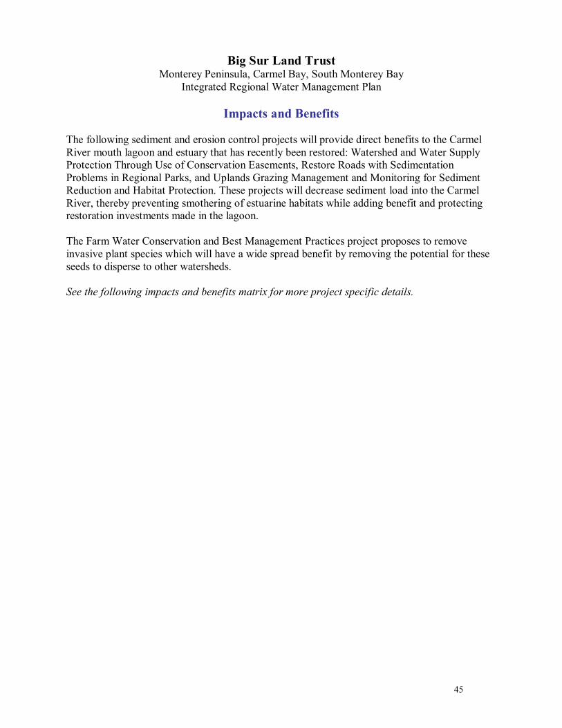
45
Big Sur Land Trust Monterey Peninsula, Carmel Bay, South Monterey Bay
Integrated Regional Water Management Plan
Impacts and Benefits The following sediment and erosion control projects will provide direct benefits to the Carmel River mouth lagoon and estuary that has recently been restored: Watershed and Water Supply Protection Through Use of Conservation Easements, Restore Roads with Sedimentation Problems in Regional Parks, and Uplands Grazing Management and Monitoring for Sediment Reduction and Habitat Protection. These projects will decrease sediment load into the Carmel River, thereby preventing smothering of estuarine habitats while adding benefit and protecting restoration investments made in the lagoon. The Farm Water Conservation and Best Management Practices project proposes to remove invasive plant species which will have a wide spread benefit by removing the potential for these seeds to disperse to other watersheds. See the following impacts and benefits matrix for more project specific details.
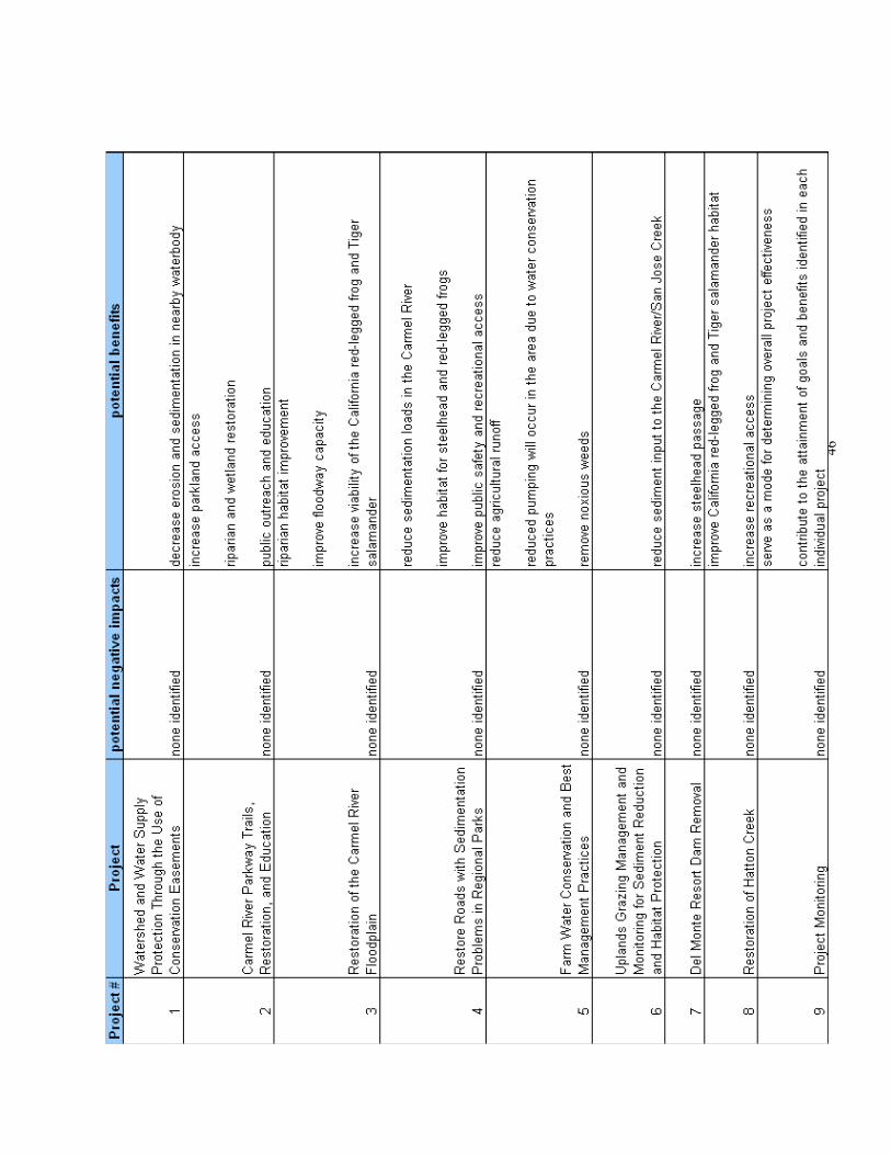
46

47
Big Sur Land Trust Monterey Peninsula, Carmel Bay, South Monterey Bay
Integrated Regional Water Management Plan
Technical Analysis Big Sur Land Trust has proposed a monitoring project that will measure overall effectiveness of project implementation as it relates to water management and integration strategies. This project will help define and implement the Project Assessment and Evaluation Plan for projects put forward for grant funding.
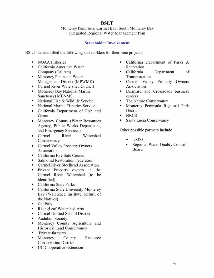
48
BSLT Monterey Peninsula, Carmel Bay, South Monterey Bay
Integrated Regional Water Management Plan
Stakeholder Involvement BSLT has identified the following stakeholders for their nine projects: NOAA Fisheries California American Water
Company (Cal Am) Monterey Peninsula Water
Management District (MPWMD) Carmel River Watershed Council Monterey Bay National Marine
Sanctuary) MBNMS National Fish & Wildlife Service National Marine Fisheries Service
• California Department of Fish and Game
• Monterey County (Water Resources Agency, Public Works Department, and Emergency Services)
• Carmel River Watershed Conservancy
• Carmel Valley Property Owners Association
California Fire Safe Council Salmonid Restoration Federation Carmel River Steelhead Association Private Property owners in the
Carmel River Watershed (to be identified)
California State Parks California State University Monterey
Bay (Watershed Institute, Return of the Natives)
Cal Poly RisingLeaf Watershed Arts Carmel Unified School District Audubon Society Monterey County Agriculture and
Historical Land Conservancy Private farmer/s Monterey County Resource
Conservation District UC Cooperative Extension
California Department of Parks &
Recreation California Department of
Transportation Carmel Valley Property Owners
Association Barnyard and Crossroads business
centers The Nature Conservancy Monterey Peninsula Regional Park
District NRCS Santa Lucia Conservancy
Other possible partners include
USDA Regional Water Quality Control
Board

49
Coordination with Other Agencies All nine of BSLT projects will be done in direct partnership with various agencies including The Nature Conservancy and Monterey Peninsula Regional Park District. Obstacles to Project Implementation No obstacles to implementation have been identified for any of the nine BSLT projects proposed.

50
Big Sur Land Trust Monterey Peninsula, Carmel Bay, and South Monterey Bay
Integrated Regional Water Management Plan
Data Management
Public Outreach Big Sur Land Trust has three strategic arenas that serve as the fundamental basis of the organization. Three main goals of the organization are protecting the best natural assets, connecting projects with people, and ensuring long- term capacity to sustain conservation investments. Therefore, BSLT will place an emphasis on public outreach during implementation of the proposed projects. Three newsletters are distributed by BSLT yearly in which project details and status will be shared. BSLT is also in working in partnership with UC Berkley, UC Santa Cruz, and CSU Monterey Bay for various aspects of project development. Project site tours will also be provided for interested stakeholders. The Uplands Grazing Management and Monitoring for Sediment Reduction and Habitat Protection project has a built in public outreach component as it includes development of a public interpretation program and posted signage on the project site. Similarly, a component of the Carmel River Parkway Trails, Restoration, and Education project is an education site including learning, interpretation, and visitor services to inform the public of the rich diversity in the Carmel River Watershed. Monitoring Monterey Peninsula Water management District (MPWMD) MPWMD carries out surface water quality monitoring as part of its environmental protection program. Seven parameters (dissolved oxygen, carbon dioxide, pH, temperature, turbidity, conductivity, and salinity) are measured at three sites (Carmel River Lagoon, below San Clemente Reservoir, and below Los Padres Reservoir) in the CRB. In addition, temperature is measured at 12 stations along the main stem of the Carmel River. Central Coast Ambient Monitoring Program (CCAMP) The Central Coast Ambient Monitoring Program has a water quality monitoring site in the Carmel River at Highway 1. The Central Coast Long-term Environmental Assessment Network (CCLEAN) CCLEAN is a cooperative long-term monitoring program that satisfies the NPDES receiving water monitoring and reporting requirements of five entities including the Cities of Santa Cruz and Watsonville, Duke Energy, the Monterey Regional Water Pollution Control Agency, and the Carmel Area Wastewater District. CCLEAN measures inputs of possible water quality stressors and effects in nearshore waters by sampling effluent, rivers and streams, mussels, sediments and benthic communities, and nearshore waters. Effluent for each municipal discharger and rivers is sampled for persistent organic pollutants (POPs; polynuclear aromatic hydrocarbons, polychlorinated biphenyls and pesticides), nutrients, and suspended sediments using automated equipment to obtain 30-day flow-proportioned samples in the dry season and in the wet season.

51
The Uplands Grazing Management and Monitoring for Sediment Reduction and Habitat Protection project includes a monitoring component consisting of residual dry matter monitoring, vegetation monitoring, and water quality monitoring. Data from these monitoring efforts will be coordinated with monitoring efforts by the Monterey Bay National Marine Sanctuary, Monterey Peninsula Water Management District, CCAMP, CCLEAN, and the volunteer monitoring project proposed by the Carmel River Watershed Conservancy in this Integrated Regional Water Management Plan.

1
1
68
68
101
1
9
2
3
4
56
7
8
Restoration of Hatton Creek
Restore Roads with Sedimentation Problems in Regional Parks
Removal of Del Monte Resort DamProject
Monitoring
Watershed and Water Supply Protection Through Use of Conservation Easements
Uplands Grazing Management and Monitoring for Sediment Reduction and Habitat Protection
Carmel River Parkway Trails, Restoration, and Education
Farm Water Conservation and Best Management Practices
Restoration of the Carmel River Floodplain
SR 1
SR 68 US 101
Seaside
Chualar
Big Sur
Monterey
Carmel Valley
Carmel
Carmel
River
Watershed
0 5 Miles
Big Sur Land Trust Project Locations
Monterey Peninsula, Carmel Bay, and South Monterey Bay Integrated Regional Water Management Plan

Carmel River Watershed Conservancy Integrated Regional Water Management Program Project Summary
Year 2005 PROJECT TITLE: Carmel River Watershed Water Quality Volunteer Monitoring Program (VMP) PROJECT SUMMARY: The CRVMP Plan will provide guidance for design and implementation of a 3-year program, including identifying VMP goals and objectives, establishing a Technical Advisory Committee, determining appropriate water quality program parameters and targets, developing a certified Quality Assurance Program Plan (QAPP), developing a database that will be accessible by decision makers and will also integrate existing monitoring data, coordinating with jurisdictional agencies to assure efficient development to meet data needs and avoid redundancy, and identifying implementation funding and ongoing program operating support. The VMP will in part be modeled on existing successful VMP’s in the region (Monterey Bay National Marine Sanctuary and the Morro Bay National Estuary Program), and will also consider the experience of other programs in the state and nation for implementation of a VMP, effective volunteer training methods, as well as ongoing program operation. The VMP will describe phases of implementation and development of specific technical tools for water quality monitoring including a Quality Assurance Program Plan (QAPP), characterization of the watershed that addresses unique elements of the Carmel River, its tributaries and watershed, and establish a design for ambient water quality monitoring that also supports trend monitoring data assessments. The QAPP will be reviewed and certified by the Central Coast Regional Water Quality Control Board. PROJECT DIRECTOR: Clive Sanders, Administrator Carmel River Watershed Conservancy E-mail Address: [email protected] P. O. Box 223833 Carmel CA 93922-3833 Tel: (831) 624-1064 Fax: (831) 625-0716 GRANT FUNDS REQUESTED: $300,000. LOCAL/OTHER MATCH FUNDING COMMITTED: $33,000. TOTAL COST: $333,000. PROJECT GOAL AND BENEFITS: Create a Carmel River Watershed Water Quality Volunteer Monitoring Program that incorporates water quality monitoring goals and objectives to evaluate hydrologic and water quality indicators of the health and stability of the Carmel River and its tributaries. The 3-year program to establish the Carmel River Volunteer Monitoring Program (VMP), will include guidance on appropriate methodologies and protocols for ambient water quality monitoring, a Quality Assurance Program Plan, as well as development of a database compatible with the Central Coast Ambient Monitoring Program (Central
Project 5 - Carmel River Watershed Water Quality Volunteer Monitoring Program June 20, 2005 Page 1

Project 5 - Carmel River Watershed Water Quality Volunteer Monitoring Program June 20, 2005 Page 2
Coast Regional Water Quality Control Board) that will provide access to data by decision-makers and support an adaptive management processes to determining future management actions. The Carmel River Watershed Action Plan (Carmel River Watershed Conservancy 2005) recommends two critical types of monitoring necessary to quantify existing problems identified in the Carmel River Watershed Assessment (2004). Action (SED-4) to monitor sediment transport in concert with surface flow monitoring conducted by the MPWMD would provide understanding of the locales where erosion and other problems are producing high levels of sediment discharge, as well as other contaminants associated with nonpoint source pollution that are entering creeks and the main stem of the river. Monitoring flow (FLOW-7) of the Carmel River and its tributaries would also help to evaluate seasonal in-migration and out-migration of steelhead to provide critical data on barriers to fish passage. Regional efforts to implement a range of programs in the Carmel Valley and in the coastal areas adjacent to the Monterey Bay are proposed as part of a collaborative action to establish an IRWMP for the Monterey Peninsula. Establishing an ambient water quality and flow monitoring program for the Carmel River and its tributaries as part of the IRWMP will provide critical data to evaluate impacts as well as other dynamic influences throughout the watershed that will occur during implementation of projects designed to improve water quality through reduction of nonpoint source pollution, improve fish passage, and restore aquatic habitats in the upper and lower watershed and river basin. Furthermore, the San Clemente Dam Seismic Hazard Remediation Project proposed by California American Water Company (Federal Register, 9/30/04) is currently undergoing an EIR/EIS process that will select from one of five proposed alternative projects to address seismic and flood risks associated with the dam structure. Project alternatives include dam buttressing, notching, or complete removal of the dam structure. Regardless of the selected project as an outcome of the EIR/EIS, construction and other activities associated with work on the dam, including construction of new access roads to allow for ingress and egress of heavy equipment, and other related actions occurring in the river channel above the current dam structure (approximately 18 miles upstream of the mouth of the river) will cause impacts to the function of the river downstream of the dam during the construction period. The timeframe for completion of the proposed work could involve from 2 to 5 years of construction and related activity. Under these circumstances, it is essential that a water quality monitoring design be implemented that will systematically identify long-term and short-term impacts to the river and watershed associated with the range of proposed and planned projects that will certainly be implemented during the next 5 years. Restoration, mitigation, and other considerations to protect environmental quality of the watershed will also require monitoring data to fully assess successful actions, develop adaptive management approaches that respond to ineffective or less effective programs, and to determine full restoration levels to support a healthy river system, wildlife habitat and the watershed as a whole.

Project 5 - Carmel River Watershed Water Quality Volunteer Monitoring Program June 20, 2005 Page 3
Implementation of a water quality monitoring program would also respond to the Central Coast Regional Water Quality Control Board’s (RWQCB) responsibility for implementing the Clean Water Act, Section 319, which requires states to institute monitoring and control of nonpoint source pollution, as well as the RWQCB’s Water Quality Control Plan (Basin Plan). As part of this work, the RWQCB has established the Central Coast Ambient Monitoring Program (CCAMP) designed to coordinate and support Volunteer Monitoring Program data acquisition procedures and documentation to facilitate accessibility of the data for management uses. Additionally, Carmel Bay and its watershed are listed in the Critical Coastal Areas (CCA) Program, jointly administered as a component of California’s NPS Plan by the California Coastal Commission and the State Water Resource Control Board. CCA’s are comprised of high quality coastal waters not yet impacted by nonpoint source pollution, and are designated as State Water Quality Protection Areas (formerly called Areas of Special Biological Significance). A monitoring program would provide critical information currently not available to identify trends and increasing impacts to Carmel Bay associated with changes in land use that derive from a range of activities that include construction of new roads and housing developments, poorly maintained older roads, urban run-off, and agricultural run-off. PROJECT TIMELINE:
o January 2007 – Hire Program Manager and Volunteer Coordinator o February 2008 – Develop volunteer recruitment strategy and initial training
sessions (based on existing monitoring sites and protocols: CCAMP, MBNMS, MPWMD), year 1
o March 2007 - Establish the TAC and working strategy to create the VMP, including QAPP
o September 2007 – First Draft of the VMP Plan for review and comment o November 2007 – Submit QAPP to the CCRWQCB for certification o January 2008 – Final VMP Plan complete and ready for implementation,
including final design of database o February 2008 – Develop volunteer recruitment strategy and hold first training
sessions (including addition of new monitoring sites), year 2 o March 2008 – TAC annual review and input to VMP o December 2008 – Annual report of VMP implementation and accomplishments o February 2009 – Revise volunteer recruitment strategy and hold training
sessions (including addition of new monitoring sites), year 3 o March 2009 – TAC annual review and input to VMP o December 2009 – Annual report of VMP implementation and accomplishments
WATERSHED: Carmel River Watershed (the mouth of the Carmel River at Carmel Bay, 36.536˚N, 121.927˚W; San Clemente Dam, 36.436˚N, 121.708˚W; and Los Padres Dam, 36.386˚N, 121.667˚W). COUNTY: Monterey

Project 5 - Carmel River Watershed Water Quality Volunteer Monitoring Program June 20, 2005 Page 4
PROJECT CATEGORY: Meets the following objectives of the IRWM/ICWM Plan: 4.4. Restore ecosystems 4.5. Maintain and/or improve water quality 4.7. Resolve conflicts and legal issues PROJECT STATUS: The CRWC Carmel River Watershed Action Plan identified the need for a Volunteer Monitoring Program in its January 2005 report to the SWRCB. The Action Plan was developed with input from public and private land owners, resource specialists, and the general public, signaling support and interest in establishing a VMP. Taking action to implement a Carmel River Watershed VMP will provide the essential component to assess and evaluate ongoing impacts related to water conservation and water quality projects that will occur as part of the IRWMP process. Additionally, as the Action Plan is implemented by local groups including the Carmel River Watershed Conservancy, the VMP will also help to establish local stewardship practices among the watershed stakeholders through direct experience in assessing impacts to water quality and quantity. Based on recommendations for establishing a VMP developed through the Action Plan public review process, this project will be ready for implementation immediately upon funding. COLLABORATIVE PARTNERSHIPS: The VMP will develop a stakeholder-based Technical Advisory Committee (TAC) that will include representatives of jurisdictional agencies, community groups and organizations, educational and research organizations, and individuals with interest in watershed management processes, wildlife protection, and beneficial uses for the community. Agency representatives that cannot actively participate in the TAC will receive regular updates and be given opportunities to review the VMP as it develops, including training manuals and QAPP documents, in order to assure an effective VMP strategy and program feasibility.
NOAA Fisheries US Fish & Wildlife Service California Department of Fish & Game Central Coast Regional Water Quality Control Board California Coastal Commission California Coastal Conservancy Monterey Peninsula Water Management District Monterey County (Water Resources, Public and Environmental Health) Monterey Peninsula Parks District Resources Conservation District Natural Resources Conservation Service CSUMB Watershed Institute CSUMB Sea Lab Carmel Valley Middle School Carmel River Watershed Conservancy Carmel River Steelhead Association Rising Leaf Public and private land owners California-American Water Co.


CCAARRMMEELL RRIIVVEERR WWAATTEERRSSHHEEDD CCOONNSSEERRVVAANNCCYY,, EEXXHHIIBBIITT CC
Cost Estimate Table Proposal Title: Monterey Peninsula, Carmel Bay, and South Monterey Bay
Integrated Regional Water Management Plan and Integrated Coastal Watershed Management Plan
Project Title: Carmel River Watershed Volunteer Monitoring Program
Budget Category Non-State Share(Funding Match)
Requested State Share
(Grant Funding) Total
(a) Direct Project Administration Costs ------------------------------------ $$ 3300,,000000.. $$ 3300,,000000..
(b) Land Purchase/Easement -------------------------------------- -------------------------------------- --------------------------
(c) Planning/Design/Engineering/Environmental Documentation
-------------------------------------- $$ 3355,,555500.. $$ 3355,,550000..
(d) Construction/Implementation $$ 3333,,000000.. $$222255,,445500.. $$225588,,445500..
(e) Environmental Compliance/Mitigation/Enhancement -------------------------------------- $$ 99,,000000.. $$
99,,000000..
(f) Project Summary [Sum (a) through (e) for each column] $$ 3333,,000000.. $$330000,,000000.. $$333333,,000000..
(g) Construction Administration ------------------------------------ ---------------------------------- --------------------------
(h) Other (Explain): _______________________________ -------------------------------------- -------------------------------------- ------------------------
(i) Construction/Implementation Contingency ------------------------------------ -------------------------------------- ------------------------
(j) Grant Total [Sum (f) through (i) for each column] $$ 3333,,000000.. $$330000,,000000.. $$333333,,000000..
Source(s) of funds for Non-State Share (Funding Match) Volunteer hours (1100 hrs./year x 3 years @ $10./hour)

Agency Name: Monterey County Water Resources Agency Project Title: Lower Carmel River Flood Control Project Project Description: County Services Area 50 (CSA-50) is a developed area of approximately 146.8 acres that is located on the Lower Carmel River, near Carmel, CA. Of the 146.8 acres, approximately 104.8 acres flood during 50-year flood event, which equates to approximately 224 residential buildings and 848,000 sq. ft. of commercial space. During a 100-year flood event the entire CSA-50 will be flooded and is approximately 365 residential buildings and 1,163,000.00 sq. ft. of commercial space. A set of structural and operational improvements has been identified that will potentially reduce flood hazards in the Lower Carmel River. The recommended structural improvements include adding pumping capacity, installing floodwalls, raising and extending levees and grading on the south floodplain of the Carmel River. Recommended operations improvements include the preparation of operations and maintenance plans for pumping facilities and adaptive management of vegetation at strategic points along the south bank of the Carmel River. Project Director: Bob Meyer, Chief, Operations and Maintenance Division, MCWRA P.O. Box 930 Salinas, CA 93902 (831) 755-4860 telephone (831) 424-7935 fax [email protected] Grant Funds Requested: $225,000.00 Local Cost Match: $25,000.00 Start Date: July 1, 2006 Project Goals and Benefits:
Reduce the frequency and magnitude of flooding within the CSA-50 area and environs, including significant reduction of repetitive flood damage losses. Optimize the use of CSA-50 and other related public funds on the most cost effective
projects Schedule: FEMA Floodplain Mapping – on-going, scheduled to be completed Dec. 2005 Engineering Report – begin July 2006, if funding available Coordinates: 15°38’39.43” E 5°44’5.65” N Watershed: Carmel River County: Monterey
Project 10 – Lower Carmel River Flood Control July 12, 2005 Page 1

Cooperating Entities: Monterey County Water Resources Agency, Monterey County Public Works, and County Services Area 50 Project Category: Flood control. This project is consistent with the strategies described in Section 5.5 of the Work Plan for the Monterey Peninsula, Carmel Bay, and South Monterey Bay Regional Water Management Plan and Integrated Coastal Watershed Management Plan, dated May 12, 2005. This project is one of the primary solutions to control flooding in the CSA 50 area of the lower Carmel Valley and meets the goals of the Monterey County Floodplain Management Plan of 2004. The implementation of this project will reduce the repetitive flood loss that has an estimated mean annual damage of $1,092.644.00 Project Status: A project report was completed in August of 2002 that identifies improvements, that if implemented, could reducing the flooding potential in the Lower Carmel River areas. The project is currently in the preliminary engineering stage that includes Federal Emergency Management Agency (FEMA) floodplain mapping. The FEMA floodplain mapping is being conducted to accurately identify the floodplain and floodway within the Carmel River drainage. Once the floodplain is correctly identified based on current conditions, the next step will be to finalize the preliminary engineering and modeling tasks of the project. The FEMA mapping began in 2003 with a budget of approximately $600,000.00 and will be completed in December of 2005. Once the FEMA mapping is completed, the next step in the project will be ready to proceed. In order to complete the entire $5.2 million dollar project, the following steps need to be completed:
Complete Preliminary Engineering - Phase I (in progress) o FEMA Floodplain Mapping – ongoing scheduled to be completed Dec. 2005 o Consultant Bid Process $12,500.00 MATCH o Preliminary Engineer Report $225,000.00 GRANT FUNDS o Project Management $12,500.00 MATCH
Environmental Review – Phase II Financing and Funding – Phase III Project Engineering – Phase IV Project Permits Acquisition – Phase V Right of Way Acquisition – Phase V Project Construction – Phase VI
The $250,000.00 (225,000.00 plus $25,000.00 match) for this phase (Phase I) of the Lower Carmel River Flood Control Project will be utilized to prepare a Engineering Report that will evaluate the adequacy of existing project proposals, identify preferred projects and alternatives, integrate the newly defined FEMA floodplain into existing drawings, hydraulic modeling and soil tests and borings to assist with the identification of preferred projects. It will also include the development of operations and maintenance plans for pumping facilities to increase the effectiveness of these facilities. The match portion will be used for project management expenditures and for preparing and awarding the contract for the Engineering Report. This will complete Phase I of the Lower Carmel River Flood Control Project.
Project 10 – Lower Carmel River Flood Control July 12, 2005 Page 2
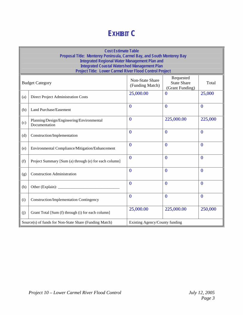
EEXXHHIIBBIITT CC
Cost Estimate Table Proposal Title: Monterey Peninsula, Carmel Bay, and South Monterey Bay
Integrated Regional Water Management Plan and Integrated Coastal Watershed Management Plan
Project Title: Lower Carmel River Flood Control Project
Budget Category Non-State Share(Funding Match)
Requested State Share
(Grant Funding) Total
(a) Direct Project Administration Costs 2255,,000000..0000 00 2255,,000000
(b) Land Purchase/Easement 00 00 00
(c) Planning/Design/Engineering/Environmental Documentation
00 222255,,000000..0000 222255,,000000
(d) Construction/Implementation 00 00 00
(e) Environmental Compliance/Mitigation/Enhancement 00 00 00
(f) Project Summary [Sum (a) through (e) for each column] 00 00 00
(g) Construction Administration 00 00 00
(h) Other (Explain): _______________________________ 00 00 00
(i) Construction/Implementation Contingency 00 00 00
(j) Grant Total [Sum (f) through (i) for each column] 2255,,000000..0000 222255,,000000..0000 225500,,000000
Source(s) of funds for Non-State Share (Funding Match) Existing Agency/County funding
Project 10 – Lower Carmel River Flood Control July 12, 2005 Page 3

Project 13 – Sanitary Sewer System Repair and Replacment in the Cities of Monterey and Pacific Grove July 12, 2005
Page 1
Monterey Peninsula, Carmel Bay, and South Monterey Bay
Integrated Regional Water Management Plan and Integrated Coastal Watershed Management Plan
AGENCY NAME: Cities of Monterey and Pacific Grove. PROJECT TITLE: Sanitary sewer system repair and replacement in the Cities of Monterey and Pacific Grove. PROJECT DESCRIPTION: This project will repair or replace gravity and force main sewer lines in the Cities of Monterey and Pacific Grove where moderate to severe deterioration has been observed and where failure is imminent. PROJECT DIRECTOR: Monterey: Tom Reeves, City Engineer Pacific Grove: Steve Leiker, Public Works Director GRANT FUNDS REQUESTED: $8,466,750 LOCAL COST MATCH: $940,750 TOTAL BUDGET: $9,407,500 PROJECT GOAL(S) AND BENEFIT(S): Recreation and public access – This project will seek to improve the reliability of the sewage systems of Monterey and Pacific Grove. Improved reliability will reduce the number of sewer system overflows (SSOs), as well as exfiltration from damaged pipes, leading to a reduction in beach closures and postings. Water quality protection and improvement – Improving the cities sewer systems will reduce microbial contamination of surface and near-shore ocean waters. Additionally, emerging contaminants such as personal care products and other compounds associated with human waste will similarly be reduced. NPS pollution control – This project will reduce NPS pollution from exfiltrating sewage lines. Water and wastewater treatment – This project will improve wastewater treatment by reducing system failures and repairing deficiencies that reduce overall system effectiveness. Background

Project 13 – Sanitary Sewer System Repair and Replacment in the Cities of Monterey and Pacific Grove July 12, 2005
Page 2
The Monterey Peninsula is a unique interface between the land and sea that draws 5 million visitors each year to the county and generates 1.75 billion dollars of tourism revenue (2.46% of the California total). Residents and visitors alike are passionate about preserving the health of the marine environment. The Monterey Peninsula’s vitality is dependent on the health of the ocean that surrounds it. One of the greatest threats to the region’s economic stability and environmental health is the adverse impact posed by poor water quality and by beach closures or postings. World class diving, kayaking, surfing and swimming lure thousands into waters that represent a growing health risk. The Peninsula is also home to the nation’s largest kelp forests which are exceptionally rich in species diversity and provide key habitat for threatened populations of Southern sea otter. Human pathogens such as gastrointestinal parasites, have recently been documented in local sea otters and may be a factor in the slow recovery of the species. The Monterey Peninsula also has a significant aquaculture and kelp harvesting industry that is highly dependent upon unpolluted water. Unfortunately, these uses can all be adversely impacted by beach closures and postings. Contributing factors to postings and closures include anthropogenic sources such as cracks, leaching and clogging in aging sanitary system infrastructure and illicit connections. These problems must be addressed by repairs and replacements at known locations of pipe failure as well as additional diagnostic work on the lines. Both the City of Monterey and the City of Pacific Grove have evaluated their sewer systems and identified priority repair and replacement projects. Funding for the most critical projects (sewer lines graded C, D, or F; A for good condition through F for failing) is requested under this grant. Old or damaged sewer lines can lead to discharges of untreated waste through exfiltration to adjacent soil and ground water, or through sewage system overflows that result from catastrophic pipe failures or ruptures. City of Pacific Grove In May of 2004, the City of Pacific Grove accepted a Sewer System Asset Management Report prepared by HDR Engineering, Inc. The purpose of the SSAMP is to provide guidance to the City in the management of the City’s sewer system asset. The SSAMP report details 7,616 feet of sewer pipe graded C, D, or F, requiring over $1.4 million in repair costs (2004 dollars). City of Monterey In February of 2000, the City of Monterey completed a system study of the sanitary sewer system with televised recordings of all lines and “report card” rating of the pipe conditions. In August of 2001, a pre-design study was completed, taking all of the information from the initial study and putting together 22 rehabilitation projects for the pipes rated in the ‘C’, ‘D’, and ‘F’ categories. In September 2002, the first project was completed at a cost of approximately $700,000. The City has since completed project plans and specifications for an additional $1.5 million in rehabilitation to the sanitary sewer system. This latest project is anticipated to go to bid and be constructed in late

summer 2005. The remaining projects which include pipes rated C, D, and F are anticipated to cost approximately $8 million.
Monterey County Beach Closures and Postings 2000 - 2003
0
5
10
15
20
25
30
35
11th
and
Oce
anview
13th
and
Oce
anview
14th
and
Ocie
nview
7th an
d Oce
anview
Asilo
mar
Cora
l and
Oce
anview
Del M
onte
Bea
ch
Foun
tain and
Oce
anview
Herita
ge H
arbo
r
Love
r's Point
Macca
bee Be
ach
Mon
tere
y Plaz
a Be
ach
San
Carlo
s Be
ach
Seal R
ock, Peb
ble Be
ach
Span
ish B
ay B
each
Stillw
ater
Cov
e
Suns
et D
r. @
Are
na /
Asilo
mar
Beach
2000 Closures
2000 Postings
2001 Closures
2001 Postings
2002 Closures
2002 Postings
2003 Closures
2003 Postings
Figure 1 CCTV Assessment Results (from SSAMP) SCHEDULE: Start: April 2006. Stop: Expected project duration – 24 months COORDINATES: N/A Throughout both cities. WATERSHED: N/A Throughout both cities. COUNTY: Monterey COOPERATING ENTITIES: The Cities of Monterey and Pacific Grove PROJECT CATEGORY: Objective 4.5 – Maintain or improve water quality: Improving the sewer system will reduce microbial contamination in surface and near shore ocean waters. PROJECT STATUS: Project is ready to go. Matching funds have been identified, no permits are expected to be needed.
Project 13 – Sanitary Sewer System Repair and Replacment in the Cities of Monterey and Pacific Grove July 12, 2005
Page 3

MMOONNTTEERREEYY && PPAACCIIFFIICC GGRROOVVEE EEXXHHIIBBIITT CC
Cost Estimate Table Proposal Title: Monterey Peninsula, Carmel Bay, and South Monterey Bay
Integrated Regional Water Management Plan and Integrated Coastal Watershed Management Plan
Project Title: Sanitary Sewer System Repair and Replacement Project
Budget Category
Non-State Share
(Funding Match)
Requested State Share
(Grant Funding)Total
(a) Direct Project Administration Costs $$444411,,884444 $$00 $$444411,,884444
(b) Land Purchase/Easement $$00 $$00 $$00
(c) Planning/Design/Engineering/Environmental Documentation
$$114422,,556622 $$771122,,555500 $$885555,,111122
(d) Construction/Implementation $$00 $$77,,004411,,550000 $$77,,004411,,550000
(e) Environmental Compliance/Mitigation/Enhancement $$00 $$00 $$00
(f) Project Summary [Sum (a) through (e) for each column] $$558844,,440066 $$77,,775544,,005500 $$88,,333388,,445566
(g) Construction Administration $$335566,,334444 $$00 $$335566,,334444
(h) Other (Explain): _______________________________
(i) Construction/Implementation Contingency $$00 $$771122,,770000 $$771122,,770000
(j) Grant Total [Sum (f) through (i) for each column] $$994400,,775500 $$88,,446666,,775500 $$99,,440077,,550000
Source(s) of funds for Non-State Share (Funding Match) Cities of Monterey & Pacific Grove
Project 13 – Sanitary Sewer System Repair and Replacment in the Cities of Monterey and Pacific Grove July 12, 2005
Page 4

Project 16 – Implementation of Solid Waste Removal June 22, 2005 Page 1
Monterey Peninsula, Carmel Bay, and South Monterey Bay Integrated Regional Water Management Plan and Integrated Coastal Watershed Management Plan
AGENCY NAME: Cities of Monterey and Pacific Grove PROJECT TITLE: Implementation of Solid Waste Removal Technology PROJECT DESCRIPTION: This project would curb solid waste emissions from two locations in the City of Monterey and two locations in the City of Pacific Grove. In Monterey, two sites have been chosen based on their large upstream drainage areas and their known propensity for being collection points for wayward pieces of trash. The Steinbeck Plaza/Prescott Avenue storm drain outfall in the City of Monterey and the Olivier Street/Scott Street Storm Drain are both locations that are adjacent to existing Urban Watch and First Flush monitoring locations. During the dry weather months volunteers visit the outfalls just downstream of these sites weekly to take water samples and to observe outfall conditions. In the City of Pacific Grove, two existing storm drain diversion locations have been chosen due to the need for solids separation and removal prior to diverting urban runoff to the sanitary sewer system. These locations are ideal for this technology because solids clog diversion pumps causing failure of the system. The course of action would include the investigation of available solid waste separation technologies as well as the purchase and installation of four units. This grant would fund the construction expenses and the cost of the units. PROJECT DIRECTOR: City of Monterey: Tom Reeves, City Engineer Pacific Grove: Steve Leiker, Public Works Director GRANT FUNDS REQUESTED: $ 891,000 LOCAL COST MATCH: $ 99,000 TOTAL BUDGET: $ 990,000 PROJECT GOAL(S) AND BENEFIT(S): Recreation and public access – This project will remove trash from recreational beaches, improving the quality of the recreational experience. Water quality protection and improvement –Trash is a common pollutant found in urban runoff; this project will reduce the amount of trash in several key areas in the planning region. NPS pollution control – This project will reduce NPS pollution from urban runoff. The New Monterey/Cannery Row Watershed is a representation of a number of different land uses which lead to five storm drain outfalls along Cannery Row. The majority of the watershed contains a large residential area combining both single-family

and multi-family parcels. The lower third of the watershed is comprised of commercial properties including a large tourist area. The Olivier Street/Scott Street storm drain is a 60” diameter pipe collecting drainage from much of the Old Monterey residential neighborhood as well as the Calle Principal commercial district and an area of the Monterey State Historic Park around Custom House Plaza. The State Historic Park is host to many festivals and functions throughout the year which attract many visitors to this area. The purpose of this project is to curb emissions of solid waste from two key areas in the City of Monterey and two areas in the City of Pacific Grove. Solid wastes, including styrofoam cups, plastic bags, styrofoam packaging material, and cigarette butts have been increasingly discharged to the MBNMS from these outfalls over the past several years. Though volunteers pick up refuse along the beach below these outfalls several times each week, this technology would be much more effective at reducing trash discharges. The proposed course of action will be to investigate technologies available for the separation of solid wastes from the storm water stream, and to install units in the four locations discussed above. The acceptable technology will combine 85-100% efficiency in the removal of water-borne litter and ease of maintenance. The specific activities to be funded by this grant include construction expenses and the cost of the units. Matching funds will be provided by the Cities of Monterey and Pacific Grove through the administrative, technical, and ongoing maintenance required to investigate available technologies, and then to properly size, install, and maintain the unit. Matching funds also include the materials and time spent by the City in the ongoing effort of monitoring these outfalls. SCHEDULE: This project will begin in April 2006 with a month-long investigation of available solid waste separation technologies for stormwater systems. Site specific design, including sizing the units, checking site logistics, and actual design of the system will be accomplished over three-and-a-half months. The design portion of the project will include production of a complete set of design drawings and installation specifications. Purchase of a properly-sized unit, including time for manufacture and delivery will be accomplished in four months. Construction will commence during the dry season following purchase of an appropriately sized unit. COORDINATES: Latitude North (decimal degrees); Longitude W (decimal degrees) Monterey: N36.6160 W121.8992 and N36.6092 W121.8951 Pacific Grove: N36.6212 W121.9201and N36.6263 W121.9158 WATERSHED: Monterey: Irving Gulch/Cannery Row; North Old Town
Project 16 – Implementation of Solid Waste Removal June 22, 2005 Page 2

Project 16 – Implementation of Solid Waste Removal June 22, 2005 Page 3
COUNTY: Monterey COOPERATING ENTITIES: Cities of Monterey and Pacific Grove PROJECT CATEGORY: Objective 4.5 – Maintain or improve water quality: Removing trash from urban runoff will improve water quality. PROJECT STATUS: Project is ready to go. Matching funds have been identified, no permit delays are expected. The California Coastal Commission permit is the only permit that is needed. This is expected to be approved without controversy.

MMOONNTTEERREEYY && PPAACCIIFFIICC GGRROOVVEE EEXXHHIIBBIITT CC
Cost Estimate Table Proposal Title: Monterey Peninsula, Carmel Bay, and South Monterey Bay
Integrated Regional Water Management Plan and Integrated Coastal Watershed Management Plan
Project Title: Implementation of Solid Waste Removal Technology Project
Budget Category
Non-State Share
(Funding Match)
Requested State Share
(Grant Funding)Total
(a) Direct Project Administration Costs $$3377,,550000 $$3377,,550000
(b) Land Purchase/Easement $$00 $$00 $$00
(c) Planning/Design/Engineering/Environmental Documentation
$$2244,,000000 $$6666,,000000 $$9900,,000000
(d) Construction/Implementation $$00 $$775500,,000000 $$775500,,000000
(e) Environmental Compliance/Mitigation/Enhancement $$00 $$00 $$00
(f) Project Summary [Sum (a) through (e) for each column] $$5522,,550000 $$882255,,000000 $$887777,,550000
(g) Construction Administration $$3377,,550000 $$00 $$3377,,550000
(h) Other (Explain): _______________________________
(i) Construction/Implementation Contingency $$00 $$7755,,000000 $$7755,,000000
(j) Grant Total [Sum (f) through (i) for each column] $$9999,,000000 $$889911,,000000 $$999900,,000000
Source(s) of funds for Non-State Share (Funding Match) Cities of Monterey and Pacific Grove
Project 16 – Implementation of Solid Waste Removal June 22, 2005 Page 4

Project 17 – Microbial Source Tracking in the Cities of Monterey and Pacific Grove July 12, 2005 Page 1
Monterey Peninsula, Carmel Bay, and South Monterey Bay Integrated Regional Water Management Plan and Integrated Coastal Watershed Management Plan
AGENCY NAME: Cities of Monterey and Pacific Grove PROJECT TITLE: Microbial Source Tracking in the Cities of Monterey and Pacific Grove PROJECT DESCRIPTION: This project will analyze water samples for the source of bacteria found in water samples providing critical data for the management of bacterial contamination that leads to beach closures and postings in the Monterey Peninsula Region. PROJECT DIRECTOR: Bridget Hoover, Monterey Bay Sanctuary Foundation GRANT FUNDS REQUESTED: $216,000 LOCAL COST MATCH: $36,000 (NOAA match for Network Coordinator – in kind salary) $6,000 each for Monterey and Pacific Grove Urban Watch / First Flush. $36K TOTAL TOTAL BUDGET: $252,000 PROJECT GOAL(S) AND BENEFIT(S): Recreation and public access – This project will ultimately lead to improvements in the reliability of the sewage systems of Monterey and Pacific Grove resulting in cleaner beaches and safer recreation opportunities. Water quality protection and improvement – Improving our knowledge of sewage sources will lead to management measures that reduce microbial contamination of surface and near-shore ocean waters. Additionally, emerging contaminants such as Endocrine Disrupting Compounds (EDC’s) and other compounds associated with human waste will similarly be reduced. NPS pollution control – This project will identify sources of NPS pollution. Water and wastewater treatment – This project will identify sources of bacterial contamination resulting in the ability to target treatment or elimination of those sources. Background The Monterey Peninsula is a unique interface between the land and sea that draws 5 million visitors a year to the county and generates 1.75 billion dollars of tourism revenue (2.46% of the California total). Residents and visitors alike are passionate about preserving the health of the marine environment.

The Monterey Peninsula’s vitality is dependent on the health of the ocean that surrounds it. One of the greatest threats to the region’s economic stability and environmental health is the adverse impact posed by poor water quality and by beach closures or postings. World class diving, kayaking, surfing and swimming lure thousands into waters that represent a health risk. The Peninsula is also home to the nation’s largest kelp forests which are exceptionally rich in species diversity and provide key habitat for threatened populations of Southern sea otter. Human pathogens such as gastrointestinal parasites, have recently been documented in local sea otters and may be a factor in the slow recovery of the species. The Monterey Peninsula also has a significant aquaculture and kelp harvesting industry that is highly dependent upon unpolluted water.
Monterey County Beach Closures and Postings 2000 - 2003
0
5
10
15
20
25
30
35
11th
and
Oce
anview
13th
and
Oce
anview
14th
and
Ocie
nview
7th
and Oce
anview
Asilo
mar
Cora
l and
Oce
anview
Del M
onte B
each
Foun
tain and
Oce
anview
Herit
age Ha
rbor
Love
r's Point
Macca
bee Be
ach
Mon
tere
y Plaz
a Be
ach
San Ca
rlos Be
ach
Seal R
ock, Peb
ble Be
ach
Span
ish B
ay B
each
Stillw
ater
Cov
e
Suns
et D
r. @
Are
na /
Asilo
mar
Beach
2000 Closures
2000 Postings
2001 Closures
2001 Postings
2002 Closures
2002 Postings
2003 Closures
2003 Postings
However, the pathway by which these microorganisms are reaching the ocean is not clear. Contributing factors to postings and closures include anthropogenic sources such as sewage from overflows, cracks, leaching and clogging in aging sanitary system infrastructure and illicit connections. These problems must be addressed by repairs and replacements at known locations of pipe failure as well as additional diagnostic work on the lines. Other factors that contribute to coliform contamination include animals both wild and domestic as well as ubiquitous sources that are present in the soil. To date, the only monitoring that has been done prior to beach postings or closures is for total coliform. In addition, this testing is often conducted in the receiving water and not at the storm drain outfalls. While total coliform testing is useful, it doesn’t tell us where the coliform originated and therefore, it’s difficult to effectively reduce or eliminate the sources. Although much is known about anthropogenic sources of coliform, more diagnostic evaluation is needed to determine if a closure or a posting is caused by human or animal bacteria. A first step in effectively addressing this issue is better identification and tracking of the sources to distinguish among wildlife, domestic animals and human contributors. The first component is therefore, a comprehensive study using an analysis method such as ribosomal RNA typing to determine sources of coliform contamination Project 17 – Microbial Source Tracking in the Cities of Monterey and Pacific Grove July 12, 2005 Page 2

Project 17 – Microbial Source Tracking in the Cities of Monterey and Pacific Grove July 12, 2005 Page 3
in three watersheds that flow into the Sanctuary. This will be a two-year project with the microbial source tracking study conducted over the first 12 month period. The second year will entail data analysis, completion of a report, and outreach and technical follow-up with the local jurisdictions to identify appropriate management measures. One component of this proposal is a method of fingerprinting using a method such as ribosomal RNA typing to determine the source of coliform bacteria posting beaches on the PeninsulaThe study sites bordering the Sanctuary are located in Monterey County in the cities of Monterey and Pacific Grove. These are urban watersheds with a chronic history of beach closures and postings. The results of this study will provide the cities, county, Regional Water Quality Control Boards, State Water Resources Control Board and the Sanctuary with the information they need to reduce the number of beach postings and determine the true human health risk at these study locations and possibly other similar watersheds throughout the Sanctuary. For the microbial study, the Sanctuary Citizen Watershed Monitoring Network will coordinate sampling with the Monterey County Department of Environmental Health. The county laboratory will analyze samples for E. coli and ship for source analysis. The estimated cost of sampling and source analysis is $200,000. In addition to the genetic analysis, trained volunteers from the Sanctuary Citizen Watershed Monitoring Network will collect stormwater samples for fecal coliform analyses at additional locations throughout the watersheds draining to these beaches, over the same time period as the source analysis study. In addition to collecting samples during the dry and wet seasons during the Urban Watch and First Flush monitoring programs, sampling will include a comprehensive First Flush analysis at15 storm drain outfalls. This existing volunteer network has extensive experience in storm drain sampling and water quality analyses (http://montereybay.nos.noaa.gov/monitoringnetwork/). Identification of upstream areas of high bacterial concentrations will assist in the future prioritization and implementation of management measures when the study is complete. Cost for this watershed coliform monitoring will be $16,000. Contributing factors to postings and closures include anthropogenic sources such as cracks, leaching and clogging in aging sanitary sewer system infrastructure and illicit connections. These problems must be addressed by repairs and replacements at known locations of pipe failure as well as additional diagnostic work on the lines. SCHEDULE: Start: Immediately following receipt of grant agreement. Stop: Expected project duration – 24 months COORDINATES: N/A throughout cities WATERSHED: N/A throughout cities COUNTY: Monterey

Project 17 – Microbial Source Tracking in the Cities of Monterey and Pacific Grove July 12, 2005 Page 4
COOPERATING ENTITIES: Cities of Monterey and Pacific Grove, Monterey Bay Sanctuary Foundation and Monterey Bay Citizen Watershed Monitoring Network PROJECT CATEGORY: Objective 4.5 – Maintain or improve water quality: Source identification and targeting will help in efforts to reduce microbial contamination in surface and near shore ocean waters. PROJECT STATUS: Project is ready to go. Matching funds have been identified, no permits are expected to be needed.

MMOONNTTEERREEYY BBAAYY SSAANNCCTTUUAARRYY FFOOUUNNDDAATTIIOONN EEXXHHIIBBIITT CC
Cost Estimate Table Proposal Title: Monterey Peninsula, Carmel Bay, and South Monterey Bay
Integrated Regional Water Management Plan and Integrated Coastal Watershed Management Plan Project Title: Microbial Source Tracking Project
Budget Category
Non-State Share
(Funding Match)
Requested State Share
(Grant Funding)Total
(a) Direct Project Administration Costs $$2255,,992200 $$2255,,992200
(b) Land Purchase/Easement
(c) Planning/Design/Engineering/Environmental Documentation
$$3366,,000000 $$119900,,008800 $$222266,,008800
(d) Construction/Implementation
(e) Environmental Compliance/Mitigation/Enhancement
(f) Project Summary [Sum (a) through (e) for each column]
(g) Construction Administration
(h) Other (Explain): _______________________________
(i) Construction/Implementation Contingency
(j) Grant Total [Sum (f) through (i) for each column] $$3366,,000000 $$221166,,000000 $$225522,,000000
Source(s) of funds for Non-State Share (Funding Match) NOAA, Monterey Bay National Marine Sanctuary, City of Monterey, City of Pacific Grove
Project 17 – Microbial Source Tracking in the Cities of Monterey and Pacific Grove July 12, 2005 Page 5