project: san remo access strategy
TRANSCRIPT

Project: San Remo Access Strategy Final Access Strategy
Reference: 233004
Prepared for: Bass Coast Shire Council
Revision: 6
02 September 2013

Project 233004 File Access Strategy Rev6 final.doc 02 September 2013 Revision 6
Document Control Record
Document prepared by:
Aurecon Australia Pty Ltd
ABN 54 005 139 873
Aurecon Centre Level 8, 850 Collins Street Docklands VIC 3008
PO Box 23061 Docklands VIC 8012 Australia T F E W
+61 3 9975 3000 +61 3 9975 3444 [email protected] aurecongroup.com
A person using Aurecon documents or data accepts the risk of:
a) Using the documents or data in electronic form without requesting and checking them for accuracy against the original hard copy version.
b) Using the documents or data for any purpose not agreed to in writing by Aurecon.
Document control
Report Title Access Strategy
Document ID Project Number 233004
File Path P:\C&I\233004 - San Remo Access Strategy\Reports\Full report\Access Strategy Rev6.doc
Client Bass Coast Shire Council Client Contact Shannon Davies
Rev Date Revision Details/Status Prepared by Author Verifier Approver
0 17 December 2012 Draft DG LC PM
1 18 December 2012 Draft DG LC PM
2 30 January 2013 Draft DG LC PM
3 5 February 2013 Draft LC LC PM
4 12 February 2013 Draft LC LC PM PM
5 27 June 2013 Final Draft LC LC PM PM
6 2 September 2013 Final LC LC PM PM
Current Revision 6
Approval
Author Signature
Approver Signature
Name Lora Colussi Name Peter McKelvie
Title Transport Planner Title Associate

Project 233004 File Access Strategy Rev6 final.doc 02 September 2013 Revision 6
San Remo Access Strategy
Date | 2 September 2013 Reference | 233004 Revision | 6
Aurecon Australia Pty Ltd
ABN 54 005 139 873
Aurecon Centre Level 8, 850 Collins Street Docklands VIC 3008
PO Box 23061 Docklands VIC 8012 Australia
T F E W
+61 3 9975 3000 +61 3 9975 3444 [email protected] aurecongroup.com
Project 233004 File Access Strategy Rev6 final.doc 02 September 2013 Revision 6 Page i
Contents 1 Introduction 1
1.1 Background 1
1.2 Objectives of the Study 1
1.3 Themes 2
1.4 Information Sources 2
1.5 Terminology 3
2 Existing Transport Overview 4
2.1 San Remo 4
2.2 Study Area and Scope 5
2.3 Transport Network 6
2.3.1 San Remo Road Network 6
2.3.2 Constraint in the Road network 9
2.3.3 Public Transport and Taxis 9
2.3.4 Active Transport Network 13
2.4 Road Safety 14
2.4.1 Crash Statistics 14
2.4.2 Identified Intersections 14
2.5 Demographics and Existing Travel Patterns 15
2.5.1 Demographics 15
2.5.2 Travel Desire Lines 17
2.6 Policy Context 19
2.6.1 Phillip Island and San Remo Integrated Transport Plan 20
3 Key Transport Themes 22
4 Transport Issues 23
5 Transport Vision 35
6 Action Plans 37
6.1 Introduction 37
6.2 Action Plan Format 37
7 Prioritisation 61
7.1 Methodology 61
8 Recommendations 64
8.1 Preamble 64
8.2 High Priority Actions 64

Project 233004 File Access Strategy Rev6 final.doc 02 September 2013 Revision 6 Page ii
8.3 Actions Informing Other Strategies 66
8.4 Medium and Low Priority Actions 66
Index of Figures Figure Ex-1-1 - Access Strategy boundary and future development areas iii Figure 2-1 - San Remo locality plan 4
Figure 2-2 - Access Strategy boundary and future development areas 5
Figure 2-3 - San Remo road network 6
Figure 2-4 - BBQ facilities and parking located on north side of Marine Parade 7
Figure 2-5 - Marine Parade traffic count 8
Figure 2-6 - San Remo Bus Routes 10
Figure 2-7 - Panorama Drive bus stop 11
Figure 2-8 - Marine Parade bus stop 11
Figure 2-9 - Phillip Island Road bus stop 11
Figure 2-10 - Taxi and loading zone on Marine Parade, western end 12
Figure 2-11 - San Remo’s existing roadside footpath network 13
Figure 2-12 - Solitary bicycle storage facility in San Remo town centre, located on Marine Parade 13
Figure 2-13 - San Remo resident travel patterns (note: arrows illustrate indicative direction only) 18
Figure 2-14 - San Remo visitor travel pattern (note: arrows illustrate indicative direction only) 19
Figure 2-15 - Policy Map that informs the San Remo Access Strategy 21
Figure 3-1 - San Remo Access Strategy seven key themes 22
Figure 3-2 - Policy Map that informs the San Remo Access Strategy 22
Figure 5-1 - Transport vision guiding documents 35
Figure 6-1 - Action Plan themes 37
Index of Tables
Table Ex-1-1 - Main issues identified iv
Table Ex-1-2 - High priority actions vi Table Ex-1-3 - Actions informing other strategies viii Table 1-1 - Information sources 2
Table 1-2 - Acronyms and terms used in the Access Strategy 3
Table 2-1 - San Remo bus service 10
Table 2-2 - Bus stop infrastructure and issues 11
Table 2-3 - Intersections of concern 14
Table 2-4 - San Remo new development lot numbers 17
Table 2-5 - San Remo Access Strategy relevant documents 19
Table 4-1 - Key themes and issues 34
Table 7-1 - Evaluation bands – scoring criteria 61
Table 7-2 - Assessment category weightings 62
Table 7-3 - Prioritisation of actions 62
Table 7-4 - San Remo Access Strategy action evaluation matrix 63
Table 8-1 - High priority actions 64
Table 8-2 - Actions informing other strategies 66
Table 8-3 - Medium priority actions 67
Table 8-4 - Low priority actions 67
Project 233004 File Access Strategy Rev6 final.doc 02 September 2013 Revision 6 Page iii
Executive Summary
The San Remo Access Strategy Study Aurecon was commissioned to prepare the San Remo Access Strategy for Bass Coast Shire Council (BCSC). The strategy includes an assessment of the existing access conditions into, out of and around San Remo, aspirations for the future and recommended actions to achieve the transport vision for San Remo.
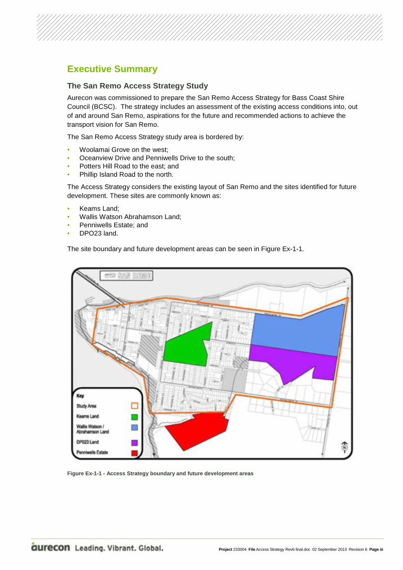
The San Remo Access Strategy study area is bordered by:
• Woolamai Grove on the west; • Oceanview Drive and Penniwells Drive to the south; • Potters Hill Road to the east; and • Phillip Island Road to the north.
The Access Strategy considers the existing layout of San Remo and the sites identified for future development. These sites are commonly known as:
• Keams Land; • Wallis Watson Abrahamson Land; • Penniwells Estate; and • DPO23 land. The site boundary and future development areas can be seen in Figure Ex-1-1.
Figure Ex-1-1 - Access Strategy boundary and future development areas
Project 233004 File Access Strategy Rev6 final.doc 02 September 2013 Revision 6 Page iv
Issues
The main issues identified in this study are listed below in Table Ex 1-1.
We have grouped these issues into themes to ensure the development of the Access Strategy considers the various key elements:
• Growth and demographics • Safety • Connectivity • Sustainable transport • Managing the network • Tourism • Heavy vehicle movements
A detailed description of each of the issues identified in the study is available in Section 4 of this report.
In addition a guiding vision for each theme has been developed. These visions have been used to guide the actions developed in this Strategy and represent San Remo communities’ wider aspirations and remain consistent with Council’s objectives.
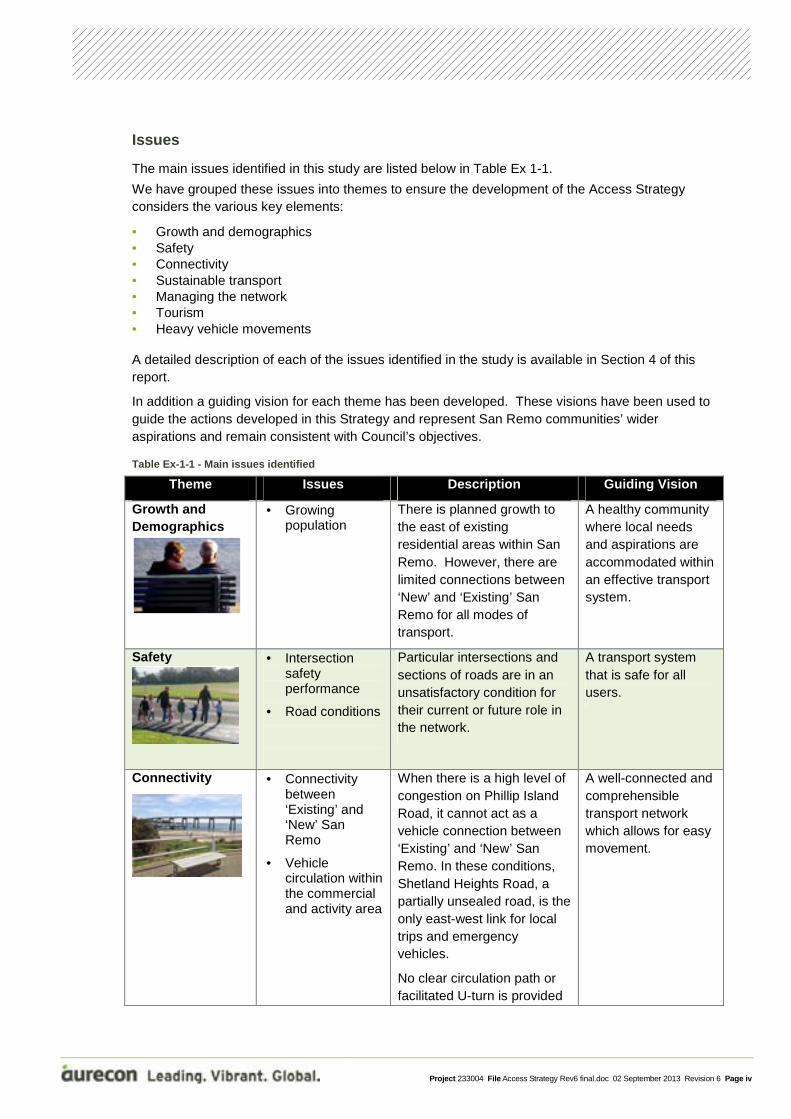
Table Ex-1-1 - Main issues identified
Theme Issues Description Guiding Vision
Growth and Demographics
• Growing population
There is planned growth to the east of existing residential areas within San Remo. However, there are limited connections between ‘New’ and ‘Existing’ San Remo for all modes of transport.
A healthy community where local needs and aspirations are accommodated within an effective transport system.
Safety • Intersection safety performance
• Road conditions
Particular intersections and sections of roads are in an unsatisfactory condition for their current or future role in the network.
A transport system that is safe for all users.
Connectivity
• Connectivity between ‘Existing’ and ‘New’ San Remo
• Vehicle circulation within the commercial and activity area
When there is a high level of congestion on Phillip Island Road, it cannot act as a vehicle connection between ‘Existing’ and ‘New’ San Remo. In these conditions, Shetland Heights Road, a partially unsealed road, is the only east-west link for local trips and emergency vehicles.
No clear circulation path or facilitated U-turn is provided
A well-connected and comprehensible transport network which allows for easy movement.
Project 233004 File Access Strategy Rev6 final.doc 02 September 2013 Revision 6 Page v
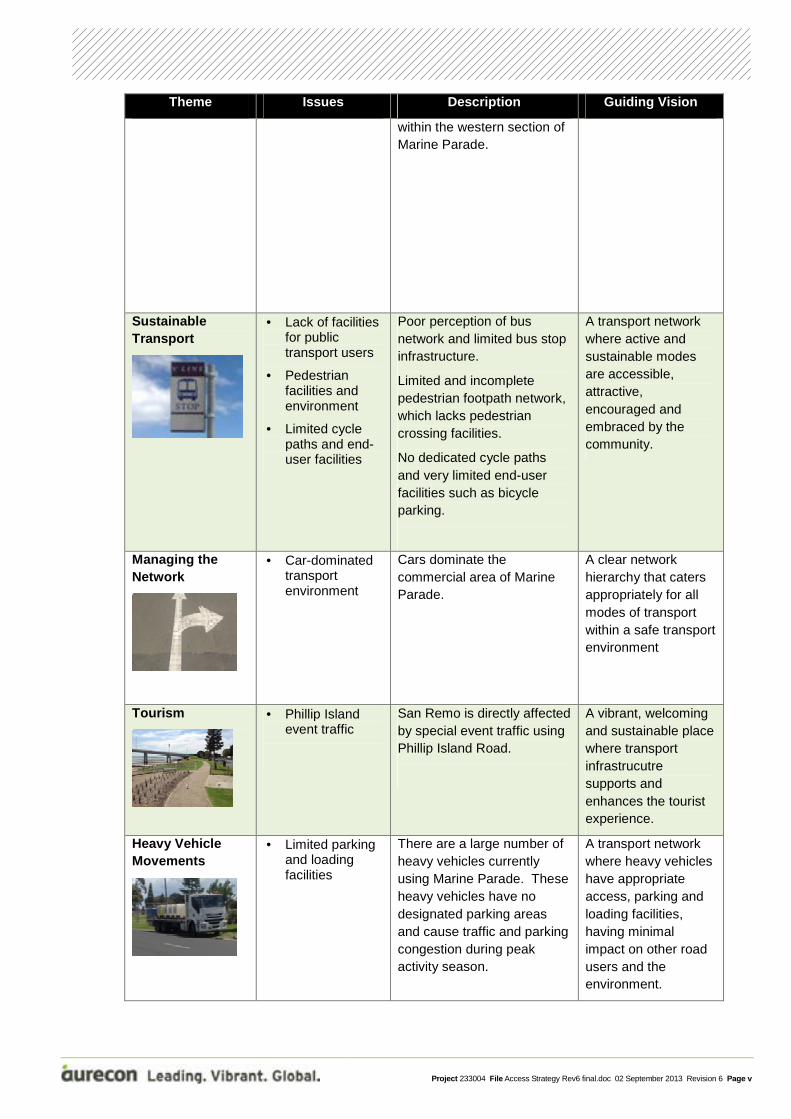
Theme Issues Description Guiding Vision
within the western section of Marine Parade.
Sustainable Transport
• Lack of facilities for public transport users
• Pedestrian facilities and environment
• Limited cycle paths and end-user facilities
Poor perception of bus network and limited bus stop infrastructure.
Limited and incomplete pedestrian footpath network, which lacks pedestrian crossing facilities.
No dedicated cycle paths and very limited end-user facilities such as bicycle parking.
A transport network where active and sustainable modes are accessible, attractive, encouraged and embraced by the community.
Managing the Network
• Car-dominated transport environment
Cars dominate the commercial area of Marine Parade.
A clear network hierarchy that caters appropriately for all modes of transport within a safe transport environment
Tourism
• Phillip Island event traffic
San Remo is directly affected by special event traffic using Phillip Island Road.
A vibrant, welcoming and sustainable place where transport infrastrucutre supports and enhances the tourist experience.
Heavy Vehicle Movements
• Limited parking and loading facilities
There are a large number of heavy vehicles currently using Marine Parade. These heavy vehicles have no designated parking areas and cause traffic and parking congestion during peak activity season.
A transport network where heavy vehicles have appropriate access, parking and loading facilities, having minimal impact on other road users and the environment.
Project 233004 File Access Strategy Rev6 final.doc 02 September 2013 Revision 6 Page vi
High Priority Recommendations
The recommended actions have been developed through consideration of the specific issues identified and guiding visions developed in this study. Actions have been prioritised according to their:
• Level of access improvement; • Relevance to San Remo or the wider BCSC; • Benefit to the population; and • Level of safety improvement.
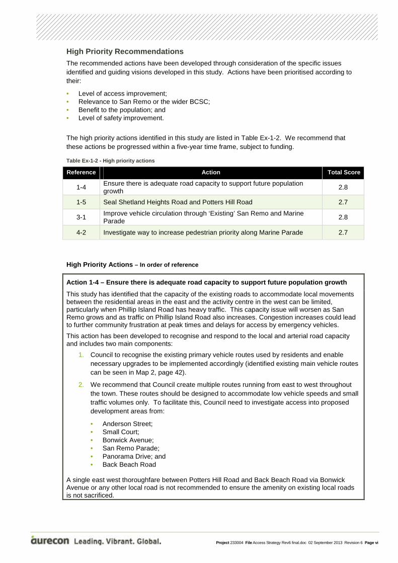
The high priority actions identified in this study are listed in Table Ex-1-2. We recommend that these actions be progressed within a five-year time frame, subject to funding.
Table Ex-1-2 - High priority actions
Reference Action Total Score
1-4 Ensure there is adequate road capacity to support future population growth
2.8
1-5 Seal Shetland Heights Road and Potters Hill Road 2.7
3-1 Improve vehicle circulation through ‘Existing’ San Remo and Marine Parade
2.8
4-2 Investigate way to increase pedestrian priority along Marine Parade 2.7
High Priority Actions – In order of reference
Action 1-4 – Ensure there is adequate road capacity to support future population growth
This study has identified that the capacity of the existing roads to accommodate local movements between the residential areas in the east and the activity centre in the west can be limited, particularly when Phillip Island Road has heavy traffic. This capacity issue will worsen as San Remo grows and as traffic on Phillip Island Road also increases. Congestion increases could lead to further community frustration at peak times and delays for access by emergency vehicles.
This action has been developed to recognise and respond to the local and arterial road capacity and includes two main components:
1. Council to recognise the existing primary vehicle routes used by residents and enable necessary upgrades to be implemented accordingly (identified existing main vehicle routes can be seen in Map 2, page 42).
2. We recommend that Council create multiple routes running from east to west throughout the town. These routes should be designed to accommodate low vehicle speeds and small traffic volumes only. To facilitate this, Council need to investigate access into proposed development areas from:
• Anderson Street; • Small Court; • Bonwick Avenue; • San Remo Parade; • Panorama Drive; and • Back Beach Road
A single east west thoroughfare between Potters Hill Road and Back Beach Road via Bonwick Avenue or any other local road is not recommended to ensure the amenity on existing local roads is not sacrificed.
Project 233004 File Access Strategy Rev6 final.doc 02 September 2013 Revision 6 Page vii
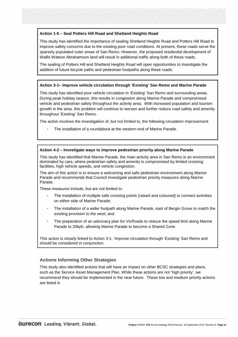
Action 1-5 – Seal Potters Hill Road and Shetland Heights Road
This study has identified the importance of sealing Shetland Heights Road and Potters Hill Road to improve safety concerns due to the existing poor road conditions. At present, these roads serve the sparsely populated outer areas of San Remo. However, the proposed residential development of Wallis Watson Abrahamson land will result in additional traffic along both of these roads.
The sealing of Potters Hill and Shetland Heights Road will open opportunities to investigate the addition of future bicycle paths and pedestrian footpaths along these roads.
Action 3-1– Improve vehicle circulation through ‘Existing’ San Remo and Marine Parade
This study has identified poor vehicle circulation in ‘Existing’ San Remo and surrounding areas. During peak holiday season, this results in congestion along Marine Parade and compromised vehicle and pedestrian safety throughout the activity area. With increased population and tourism growth in the area, this problem will continue to worsen and further reduce road safety and amenity throughout ‘Existing’ San Remo.
The action involves the investigation of, but not limited to, the following circulation improvement:
• The installation of a roundabout at the western end of Marine Parade.
Action 4-2 – Investigate ways to improve pedestrian priority along Marine Parade
This study has identified that Marine Parade, the main activity area in San Remo is an environment dominated by cars, where pedestrian safety and amenity is compromised by limited crossing facilities, high vehicle speeds, and vehicle congestion.
The aim of this action is to ensure a welcoming and safe pedestrian environment along Marine Parade and recommends that Council investigate pedestrian priority measures along Marine Parade.
These measures include, but are not limited to:
• The installation of multiple safe crossing points (raised and coloured) to connect activities on either side of Marine Parade;
• The installation of a wider footpath along Marine Parade, east of Bergin Grove to match the existing provision to the west; and
• The preparation of an advocacy plan for VicRoads to reduce the speed limit along Marine Parade to 20kph, allowing Marine Parade to become a Shared Zone.
This action is closely linked to Action 3-1, ‘Improve circulation through ‘Existing’ San Remo and should be considered in conjunction.
Actions Informing Other Strategies This study also identified actions that will have an impact on other BCSC strategies and plans, such as the Service Asset Management Plan. While these actions are not ‘high priority’, we recommend they should be implemented in the near future. These low and medium priority actions are listed in
Project 233004 File Access Strategy Rev6 final.doc 02 September 2013 Revision 6 Page viii
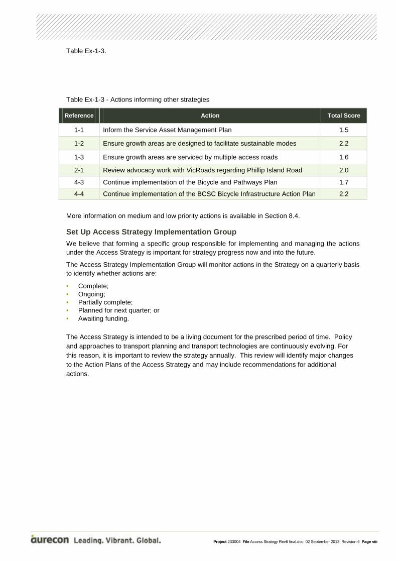
Table Ex-1-3.
Table Ex-1-3 - Actions informing other strategies
Reference Action Total Score
1-1 Inform the Service Asset Management Plan 1.5
1-2 Ensure growth areas are designed to facilitate sustainable modes 2.2
1-3 Ensure growth areas are serviced by multiple access roads 1.6
2-1 Review advocacy work with VicRoads regarding Phillip Island Road 2.0
4-3 Continue implementation of the Bicycle and Pathways Plan 1.7
4-4 Continue implementation of the BCSC Bicycle Infrastructure Action Plan 2.2
More information on medium and low priority actions is available in Section 8.4.
Set Up Access Strategy Implementation Group We believe that forming a specific group responsible for implementing and managing the actions under the Access Strategy is important for strategy progress now and into the future.
The Access Strategy Implementation Group will monitor actions in the Strategy on a quarterly basis to identify whether actions are:
• Complete; • Ongoing; • Partially complete; • Planned for next quarter; or • Awaiting funding.
The Access Strategy is intended to be a living document for the prescribed period of time. Policy and approaches to transport planning and transport technologies are continuously evolving. For this reason, it is important to review the strategy annually. This review will identify major changes to the Action Plans of the Access Strategy and may include recommendations for additional actions.
Project 233004 File Access Strategy Rev6 final.doc 02 September 2013 Revision 6 Page 1
1.1 Background In October 2012 Aurecon was commissioned to prepare the San Remo Access Strategy for Bass Coast Shire Council (BCSC).
This Access Strategy was developed to address the transport demands that will be generated by the anticipated moderate growth of San Remo, as identified in the 2008 Victorian Coastal Strategy. The San Remo Strategic Framework Plan identified that the majority of new residential growth is to be accommodated on land east of the San Remo township, with the outer extent being defined by Potters Hill Road.
The need for an Access Strategy was first identified in the 2010 San Remo, New Haven and Cape Woolamai Structure Plan. This document recognised the need for further consideration into the staging of growth in the town, with particular emphasis on the location of community services, environmental features and assets, future open spaces and the future pedestrian, cycling and road network.
In February 2012, San Remo residents participated in a community meeting with Council planning staff to identify existing access issues within the town. Outputs from this community workshop were used to develop the Access Strategy brief.
1.2 Objectives of the Study The San Remo Access Strategy includes a high level assessment of the existing access conditions into, out of and around San Remo, aspirations for the future and recommended actions to achieve the transport vision for San Remo.
As outlined in the BCSC project brief, the objectives of the study are:
• To provide clear understanding about the function and capability of the existing traffic, pedestrian and cycle network in San Remo;
• To provide a review of the key issues in the San Remo traffic, pedestrian and cycle network identified by local community;
• To provide an outline of the key areas of improvement required in the San Remo traffic, pedestrian and cycle network; and
• To provide a long term strategy for improving, movement, access and connectivity in San Remo. This strategic document will guide Council’s future planning for San Remo by: • Assisting with the assessment of future developments; • Informing Council’s Capital Works Program; • Informing Council’s Priority Infrastructure Plan for future upgrade works; and • Acting as a source document for future discussions with VicRoads.
1 Introduction
Project 233004 File Access Strategy Rev6 final.doc 02 September 2013 Revision 6 Page 2
1.3 Themes As part of the project, seven key themes were identified. Each of the existing network issues and future visions fall into one of these themes which are as follows:
1. Growth & Demographics
2. Tourism
3. Connectivity
4. Sustainable Transport
5. Managing the Network
6. Transport Safety
7. Heavy Vehicle Movements
The issues have been identified by Aurecon through consultation with community representatives, BCSC, as well as previous studies.
Aurecon developed the recommended actions by considering the specific issues identified and BCSC guiding visions. The actions are presented under each of the key themes.
1.4 Information Sources We have used several information sources during the process of identifying relevant issues. The information sources are outlined in Table 1-1 below.
Table 1-1 - Information sources
Information Source Details
Meeting and consultation workshop
• BCSC conducted a workshop to identify key issues and ideas related to transport movements within San Remo. This information was used to develop the scope for the Access Strategy and has been used to inform and direct Aurecon’s investigations.
• An inception meeting between Aurecon and BCSC was held in October 2012, where BCSC provided Aurecon with background information.
• A workshop with four community and two BCSC representatives was conducted in November 2012 to review Aurecon’s understanding of issues and to identify guiding aspirations for the strategy.
• Two workshops were held between Aurecon and BCSC representatives to review the recommended visions and actions.
• Two workshops were held between Council and San Remo residents to review the recommended actions outlined in Draft Version 4 of the strategy. These workshops were conducted on 21 and 24 March 2013.
Background research In order to understand existing conditions pertaining to transport in San Remo, Aurecon has reviewed background documentation and data. This information is outlined in Section 2 of this document.
Site inspections Two site inspections were undertaken by Aurecon in October and early November 2012. These site inspections covered a number of areas within San Remo, including Marine Parade, the foreshore, Bergin Grove, Back Beach Road, Panorama Drive, Shetland Road and other local roads. The site inspections were completed during the daytime on weekdays.

Project 233004 File Access Strategy Rev6 final.doc 02 September 2013 Revision 6 Page 3
1.5 Terminology Various acronyms and terms have been used within the Strategy. Table 1-2 lists and defines these terms.
Table 1-2 - Acronyms and terms used in the Access Strategy
Term Definition
Active transport Refers to cycling and walking, also known as sustainable transport
BCSC Bass Coast Shire Council
Collector roads Roads providing connection between local roads and the town centre and Phillip Island Road
DDA Disability Discrimination Act
Desire lines The preferred travel paths for pedestrians, cyclists or drivers
DP023 land Development Plan Overlay 23, this area has been rezoned residential land
Keams Land The area of undeveloped land located between Panorama Drive and Back Beach Road, refer to Figure 2-2
‘New’ San Remo The area of San Remo east of Back Beach Road
‘Existing’ San Remo The area of San Remo west of Back Beach Road
Penniwells Estate The area located at the southern end of Penniwells Drive, refer to Figure 2-2
PIITP Phillip Island Integrated Transport Plan
Phillip Island Road Commonly known as the Phillip Island Tourist Road
PTV Public Transport Victoria
SSD Stopping sight distance, the distance a drivers requires to observe an obstruction and stop safely
Study area The section of San Remo town considered within the San Remo Access Strategy, refer to Figure 2-2
Sustainable transport Refers to cycling or walking, also known as active transport
TEM Traffic Engineering Manual. Engineering guidelines for traffic management and signs and markings, published by VicRoads
Town Centre The commercial and retail area located along Marine Parade
Wallis Watson Abrahamson land
Also known as the Island View Estate, the area of land located adjacent to Phillip Island Road and Potters Hill Road, refer to Figure 2-2

Project 233004 File Access Strategy Rev6 final.doc 02 September 2013 Revision 6 Page 4
2.1 San Remo San Remo is located at the tip of the Anderson Peninsula, approximately 100km south east of Melbourne. It is surrounded by farmland to the east, Western Port Bay to the north and the Bass Strait coastline to the south. Phillip Island Road is San Remo’s only land connection, linking to the Bass Highway to the east and Phillip Island to the west. The location of San Remo can be seen in Figure 2-1.
Historically, the San Remo Township developed around a fishing industry, but now growth is due to its ever increasing popularity as a tourist location, providing coastal walks, fishing, pelican feeding and coastal views. In addition to the tourist growth, San Remo’s permanent population is also growing due to the ‘sea change’ phenomenon, with many retirees moving to the area.
The terrain in the western portion of the town, ‘Existing’ San Remo, is relatively flat, with the eastern portion of the town, ‘New’ San Remo, more undulating. Several streets within ‘New’ San Remo have significant grades, with the highest point in town located around The Mount Drive.
Figure 2-1 - San Remo locality plan
2 Existing Transport Overview
San Remo

Project 233004 File Access Strategy Rev6 final.doc 02 September 2013 Revision 6 Page 5
2.2 Study Area and Scope The San Remo Access Strategy study area is bordered by:
• Woolamai Grove on the west; • Oceanview Drive and Penniwells Drive to the south; • Potters Hill Road to the east; and • Phillip Island Road to the north.
As well as the existing layout of San Remo, the Access Strategy will consider the sites identified for future development. These sites are commonly known as:
• Keams Land; • Wallis Watson Abrahamson Land; • Penniwells Estate; and • DPO23 land. The site boundary and future development areas can be seen in Figure 2-2.
Figure 2-2 - Access Strategy boundary and future development areas
Please note that the Access Strategy will look at the interaction between Phillip Island Road and San Remo, but not Phillip Island Road in relation to traffic not accessing or egressing San Remo.
Project 233004 File Access Strategy Rev6 final.doc 02 September 2013 Revision 6 Page 6
2.3 Transport Network
2.3.1 San Remo Road Network
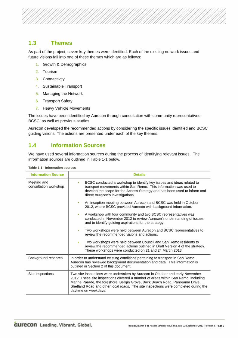
The San Remo road network consists primarily of local roads that provide access to residential properties. Within this local road network, several roads operate as links to the Town Centre or Phillip Island Road. These roads are shown in blue in Figure 2-3.
Figure 2-3 - San Remo road network
Phillip Island Road
Phillip Island Road is a two lane arterial road under the jurisdiction of VicRoads. The road runs along the length of the Anderson Peninsula and provides the only vehicle link between the Bass Highway in the east and San Remo and Phillip Island to the west. The road currently carries approximately 5,0001 vehicles per average day but is subject to seasonal and event based fluctuations that can result in daily vehicle volumes above 20,000.
In the vicinity of San Remo, Phillip Island Road has a 60km/hr speed limit and is used by local residents as a link between ‘Existing’ and ‘New’ San Remo.
In peak season and during special events on Phillip Island, traffic congestion along Phillip Island Road can make it difficult to access the road from San Remo. Under these conditions, dangerous manoeuvres are sometimes performed to access or egress the road and residents and visitors can experience long delays. Additionally, in the case of a crash or incident on the road, access to and from San Remo and Phillip Island is cut off.
1 VicRoads count statistics
Project 233004 File Access Strategy Rev6 final.doc 02 September 2013 Revision 6 Page 7
Bergin Grove, Back Beach Road, Keam Crescent, San Remo Parade, Panorama Drive and Potters Hill Road within San Remo all have unrestricted access to Phillip Island Road. Phillip Island Road has traffic priority at all of these intersections.
Marine Parade
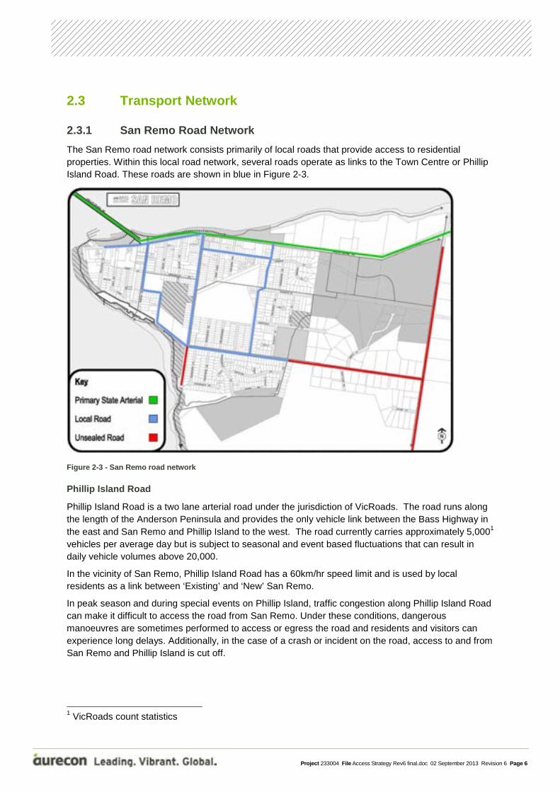
San Remo’s main commercial and activity area is located along the length of Marine Parade. The south side of Marine Parade has commercial activity, including a post office, pharmacy, cafés, boutiques, pubs, and a supermarket. The northern side of Marine Parade provides access to a playground, barbeques, toilets, fishing co-operative, bus stop, and walking track. It also provides access to the popular pelican feeding display which attracts approximately 50,000 visitors per year2, with approximately 10 coaches daily accessing Marine Parade from Bergin Avenue. Figure 2-4 shows the park and barbeque area, as well as parking bays along Marine Parade.
Figure 2-4 - BBQ facilities and parking located on north side of Marine Parade
Marine Parade is dominated by vehicles and coaches, with vehicle parking provided on both sides of the street and no formal pedestrian crossings in place. Marine Parade, west of Bergin Grove, is a no-through road. With no circulation route, vehicles are forced to perform U-turns, resulting in traffic duplication along this section of road. In addition, Marine Parade acts as a vehicle thoroughfare for Woolamai Grove residents as it provides their only access to Phillip Island Road or ‘New’ San Remo.
Two-way traffic counts collected by BCSC between 12 and 16 December 2012 along Marine Parade, west of Begin Grove, indicate that between 3,500 and 4,500 vehicles per day use the road during the peak weekend period. Midweek data indicates substantially lower traffic volumes of around 1,700 vehicles per day. The traffic volumes can be seen in Figure 2-5.
2 Community Workshop Friday 9 November 2012

Project 233004 File Access Strategy Rev6 final.doc 02 September 2013 Revision 6 Page 8
Figure 2-5 - Marine Parade traffic count
Back Beach Road
Back Beach Road is a two-lane connector road providing a north south link on the border between the ‘Existing’ and ‘New’ San Remo. The northern end of the road intersects with Phillip Island Road and Marine Parade. To the south the road connects with Shetland Heights Road and Davis Point Road. South of this intersection, the road is unsealed and leads to an unsealed car park providing access to San Remo’s back beach.
Back Beach Road is dominated by residential developments along both sides, but also plays a role in providing access to the commercial area abutting Marine Parade. It also provides access to the CFA located on the corner of Genista Street, the community centre, San Remo Preschool, a parkland and playground located at its southern end and also Keams Land, a future development site.
Bergin Grove
Bergin Grove provides primary access onto Phillip Island Road and bisects the Marine Parade commercial and activity area. It is a two-lane road providing direct access to the local primary school and residential allotments. It has a posted speed limit of 40km/hr.
Shetland Heights Road
Shetland Heights Road provides an east west connection along the southern section of San Remo. At its western end it forms an intersection with Back Beach Road and Davis Point Road. At its eastern end it forms and intersection with Potters Hill Road. The road provides access to the Penniwells Estate, the undeveloped Bass Coast Golf Resort, parkland and the Foreshore Caravan Park.
It is a sealed 60km/hr road between Back Beach Road in the west through to approximately Penniwells Drive. From here to the east, it is unsealed through to Potters Hill Road and has a speed limit of 100km/hr.
Day of the week
Project 233004 File Access Strategy Rev6 final.doc 02 September 2013 Revision 6 Page 9
Panorama Drive
Panorama Drive is a two lane road providing a north south connection in ‘New’ San Remo, linking Phillip Island Road to the north to Shetland Heights Road to the south. It abuts the eastern edge of Keams Land and has a kink at the intersection with Bonwick Avenue. It provides access to residential lots and local roads.
Genista Street
Genista Street is a local road consisting of two sections that are separated by Panorama Drive. Although not intended, Genista Street west of Panorama Drive acts as an east west connection for both vehicles and pedestrians by providing access to Back Beach Road and onto the Marine Parade commercial and activity area.
Potters Hill Road
Potters Hill Road is primarily an unsealed road with a 100km/hr speed limit, running north south on the eastern outskirts of San Remo. The road links Phillip Island Road in the north to Shetlands Heights Road in the south and provides access to the Silverwater Resort. Potters Hill Road is an identified access road for the proposed residential area on the Wallis Watson Abrahamson Land on its western border.
2.3.2 Constraint in the Road network
There are two east-west connections between ‘Existing’ and ‘New’ San Remo; Phillip Island Road, on the northern edge of the town and Shetland Heights Road located in the south.
As discussed in Section 2.3.1, easy and safe access to, and efficient travel along, Phillip Island Road is compromised due to:
• Seasonal increases in traffic volumes; • Special events on Phillip Island; and • Crashes or incidents along the road.
The impacts of these regular events or occurrences are:
• Queuing along Phillip Island Road between Phillip Island and the Bass Highway; • Long delays in travel on Phillip Island Road; and • Long delays and increased risky and hazardous driver behavior when egressing San Remo.
When this high level of congestion occurs on Phillip Island Road, it cannot act as a vehicle connection between ‘Existing’ and ‘New’ San Remo. During these conditions, Shetland Heights Road and Potters Hill Road, both partially unsealed roads, provide the only alternative route for local trips and emergency vehicles.
2.3.3 Public Transport and Taxis
Public transport to/from and within San Remo is provided by bus and taxis.
Bus Services
Public Bus Routes Three bus operators currently provide four services to the San Remo area (excluding school buses).
The V/Line and Cleeland bus services make one stop in San Remo in each direction, at the stops located on Marine Parade or Phillip island Road east of Bergin Avenue. The Cowes to Wonthaggi

Project 233004 File Access Strategy Rev6 final.doc 02 September 2013 Revision 6 Page 10
service, run by Phillip Island Bus Lines, offers a service through San Remo, with a number of stops located throughout the town. This service is also the most frequent, with up to 7 services per day in one direction.
The current bus services and frequencies are shown in Table 2-1.
Table 2-1 - San Remo bus service
Figure 2-6 shows two existing bus routes in and around San Remo.
Figure 2-6 - San Remo Bus Routes
Bus Stop Infrastructure Bus stop shelters are provided at stops located along Phillip Island Road, Marine Parade and at Woolamai Grove. All other stops have only bus stop poles with service information.
San Remo Bus Routes Frequency Operator
Cowes to Wonthaggi 5 (Mon – Thurs) and 6 (Fri)
services/day/to Wonthaggi
6 (Mon – Thurs) and 7 (Fri)
services/day/to Cowes
Phillip Island Bus Lines
Cowes to Dandenong 4 services /direction/day Mon – Fri V/Line
Cowes to Fountain Gate 1 service/direction Thurs only Cleeland
Cowes to Frankston 1 service/direction every second Mon Cleeland

Project 233004 File Access Strategy Rev6 final.doc 02 September 2013 Revision 6 Page 11
Figures 2-7, 2-8 and 2-9 below display existing bus stop infrastructure and Table 2-2 lists the issues identified with this infrastructure.
Figure 2-7 | Panorama Drive bus stop
Figure 2-8 | Marine Parade bus stop
Figure 2-9 | Phillip Island Road bus stop
Table 2-2 - Bus stop infrastructure and issues
Bus stop locations Existing Infrastructure Identified Issues
Panorama Drive
(2 sets of stop locations)
• Information pole • Shelter – none provided
• Accessibility – no paths leading to or from
stops
• No seating
• No easy access to board or alight from bus
Shetland Heights Road • Information pole • Shelter – none provided
• Accessibility – no paths leading to or from
stops
• No seating
• No easy access to board or alight from bus
Back Beach Road • Information pole
• Access path
(northbound only)
• Shelter – none provided
• Accessibility – no paths leading to or from
stops (southbound only)
• No seating
• No easy access to board or alight from bus
Marine Parade • Information pole
• Seating (eastbound
only)
• Bus shelter
• Access paths
• No seating (westbound only)
Park Road • Information pole
• Shelter – none provided
• Accessibility – no paths leading to or from
stops
• No seating
• No easy access to board or alight from bus

Project 233004 File Access Strategy Rev6 final.doc 02 September 2013 Revision 6 Page 12
Bus stop locations Existing Infrastructure Identified Issues
Woolamai Grove • Information pole
• Access path
(northbound only)
• Shelter – none provided (southbound only)
• Accessibility – no paths leading to or from
stops (southbound only)
• No seating
• No easy access to board or alight from bus
Phillip Island Road • Information pole
• Seating
• Bus shelter
• Access paths
Additional Bus Services Further to the public bus network, BCSC provide a bus service for eligible home and community care clients who are unable to access private or public transport due to age, frailty or a disability. This shuttle bus is also available for hire by community groups within the municipality when the service is not being used.
Additionally, a shuttle bus service is provided during special events between San Remo and Phillip Island, e.g. during the Phillip Island Motorcycle Grand Prix.
Local Taxi Services
Up to four local taxi companies are available to service San Remo. Cowes and San Remo Taxi Service is based in Cowes and offers 24 hour service and two vehicles for mobility impaired users. This service facilitates many short trips within San Remo for residents and visitors.
A shared taxi and loading zone is located along the south side of Marine Parade at its western end, in front of the Thirsty Camel bottle shop as shown in Figure 2-10. It should be noted that taxis are not based in this area, but must be booked in advance.
Figure 2-10 - Taxi and loading zone on Marine Parade, western end

Project 233004 File Access Strategy Rev6 final.doc 02 September 2013 Revision 6 Page 13
2.3.4 Active Transport Network
San Remo has a limited active transport network. There are no bicycle paths on or off road and the pedestrian footpath network is limited, as shown in Figure 2-11. Further to this, there are no dedicated pedestrian crossing points through the town and only one bicycle parking loop located on Marine Parade and a bicycle parking rack located at the southern end of Back Beach Road.
Based on the 2011 census, approximately 6% of those employed within San Remo walked to work (24 people), while no residents rode a bicycle to work.
Figure 2-11 - San Remo’s existing roadside footpath network
The bicycle storage loop on Marine Parade can be seen in Figure 2-12.
Figure 2-12 - Solitary bicycle storage facility in San Remo town centre, located on Marine Parade
Project 233004 File Access Strategy Rev6 final.doc 02 September 2013 Revision 6 Page 14
2.4 Road Safety
2.4.1 Crash Statistics
A review of all casualty crashes in San Remo, for a period covering 25 years (1/1/1987 to 30/10/2012 inclusive), was performed on the VicRoads crash stats database. Some of the key findings of this review were:
• There were 23 reported crashes in the last 25 years (1987-2012); - Four of these crashes included motorcyclists and two included pedestrians.
• The two reported pedestrian crashes were located at the intersection of Phillip Island Road/Back Beach Road and Phillip Island/Marine Parade; and
• There have been two reported crashes since 2007 (last five years), including one at the intersection of Bergin Grove/Marine Parade.
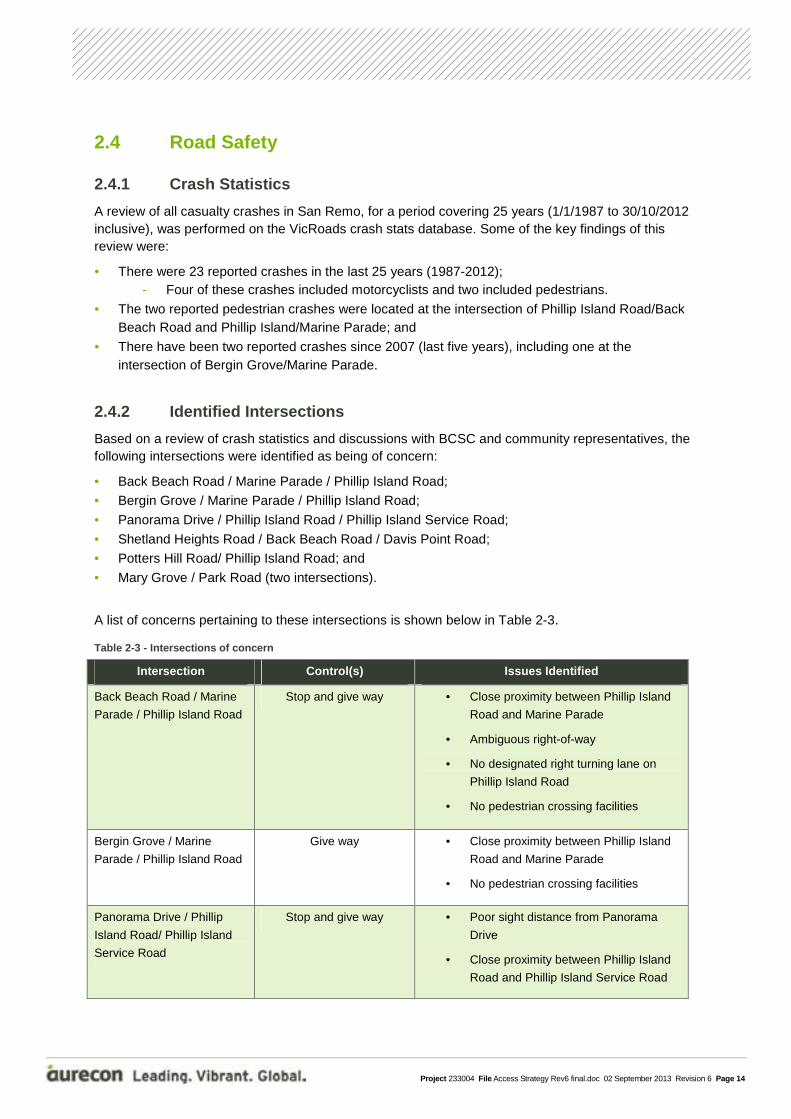
2.4.2 Identified Intersections
Based on a review of crash statistics and discussions with BCSC and community representatives, the following intersections were identified as being of concern:
• Back Beach Road / Marine Parade / Phillip Island Road;
• Bergin Grove / Marine Parade / Phillip Island Road;
• Panorama Drive / Phillip Island Road / Phillip Island Service Road;
• Shetland Heights Road / Back Beach Road / Davis Point Road;
• Potters Hill Road/ Phillip Island Road; and
• Mary Grove / Park Road (two intersections).
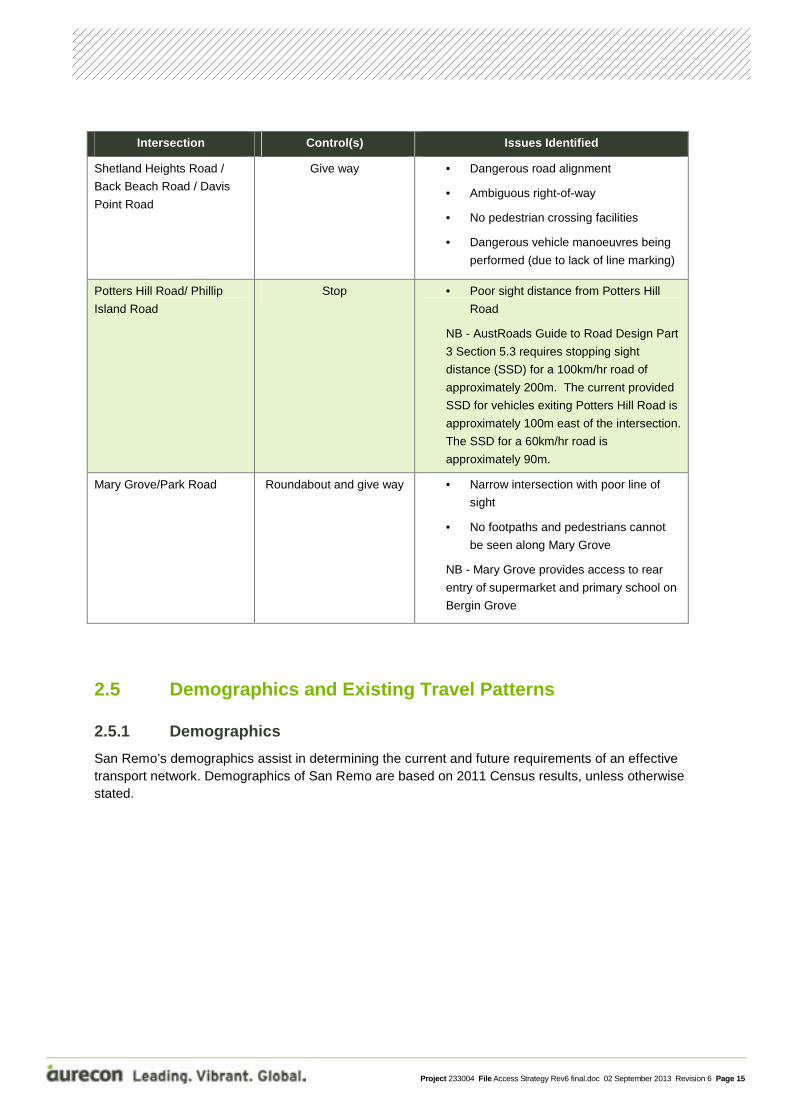
A list of concerns pertaining to these intersections is shown below in Table 2-3.
Table 2-3 - Intersections of concern
Intersection Control(s) Issues Identified
Back Beach Road / Marine
Parade / Phillip Island Road
Stop and give way • Close proximity between Phillip Island
Road and Marine Parade
• Ambiguous right-of-way
• No designated right turning lane on
Phillip Island Road
• No pedestrian crossing facilities
Bergin Grove / Marine
Parade / Phillip Island Road
Give way • Close proximity between Phillip Island
Road and Marine Parade
• No pedestrian crossing facilities
Panorama Drive / Phillip
Island Road/ Phillip Island
Service Road
Stop and give way • Poor sight distance from Panorama
Drive
• Close proximity between Phillip Island
Road and Phillip Island Service Road
Project 233004 File Access Strategy Rev6 final.doc 02 September 2013 Revision 6 Page 15
Intersection Control(s) Issues Identified
Shetland Heights Road /
Back Beach Road / Davis
Point Road
Give way • Dangerous road alignment
• Ambiguous right-of-way
• No pedestrian crossing facilities
• Dangerous vehicle manoeuvres being
performed (due to lack of line marking)
Potters Hill Road/ Phillip
Island Road
Stop • Poor sight distance from Potters Hill
Road
NB - AustRoads Guide to Road Design Part
3 Section 5.3 requires stopping sight
distance (SSD) for a 100km/hr road of
approximately 200m. The current provided
SSD for vehicles exiting Potters Hill Road is
approximately 100m east of the intersection.
The SSD for a 60km/hr road is
approximately 90m.
Mary Grove/Park Road Roundabout and give way • Narrow intersection with poor line of
sight
• No footpaths and pedestrians cannot
be seen along Mary Grove
NB - Mary Grove provides access to rear
entry of supermarket and primary school on
Bergin Grove
2.5 Demographics and Existing Travel Patterns
2.5.1 Demographics
San Remo’s demographics assist in determining the current and future requirements of an effective transport network. Demographics of San Remo are based on 2011 Census results, unless otherwise stated.

Project 233004 File Access Strategy Rev6 final.doc 02 September 2013 Revision 6 Page 16
34
3 Community Workshop Friday 9 November 2012 4 http://forecast2.id.com.au/Default.aspx?id=344&pg=5230 (November 2012)

Project 233004 File Access Strategy Rev6 final.doc 02 September 2013 Revision 6 Page 17
2.5.2 Travel Desire Lines
To understand the different travel desire lines within San Remo, travellers have been split into two groups:
• Local residents; and • Visitors.
Local Residents
Origin According to census data, in 2011 San Remo had 880 dwellings. According to the BCSC C90 amendment, a panel estimated that San Remo would require another 533 lots by 2020. These future dwellings will be located within areas including Keams land, Wallis Watson Abrahamson land, Penniwells Estate, as well as in fill land around existing developed San Remo.
The number of proposed development lots, as well as estimated daily trip generation for each area is shown in Table 2-4.
Table 2-4 - San Remo new development lot numbers
Land Number of traditional sized lots* Daily trips**
In fill other 430 3870
Keams land 100 900
Wallis Watson Abrahamson 320 2880
*Source: Panel calculation 2009 – C90 Amendment ** Based on RTA Guide to Traffic Generating Developments
The travel desire lines of residents from both existing and future residential development areas of San Remo (i.e. Keams land, Wallis Watson Abramson land and Penniwells Estate) have been identified through discussions with BCSC and a community workshop.
Destination From the community workshop it was identified that the major residential attractors in and around the town include the:
• Activity and commercial centre along Marine Parade; • Primary school; • Preschool; • Medical centre; and • Recreational facilities and the mobile library.
Local residents also regularly access facilities provided on Phillip Island, Wonthaggi and Melbourne.
Some local residents in the nearby towns of Newhaven and Cape Woolamai also use the services provided in San Remo on a regular basis.
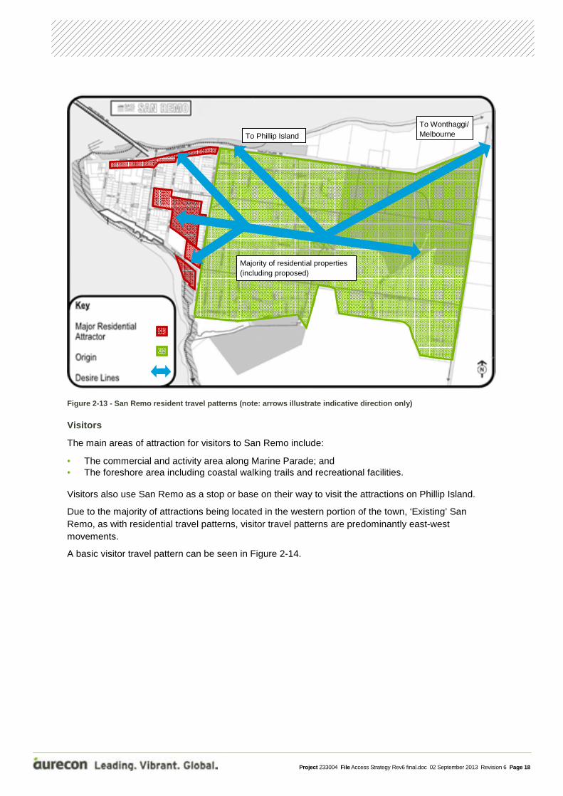
As can be seen in Figure 2-13, most attractors are located to the west of San Remo, i.e. ‘Existing’ San Remo, while most residential development is located in the east i.e. ‘New’ San Remo. This results in a strong east-west desire line for residents. However, the dependence on services and employment outside San Remo also indicates a desire line between residential areas and Phillip Island Road.
A basic residential travel desire line map is shown in Figure 2-13.
Project 233004 File Access Strategy Rev6 final.doc 02 September 2013 Revision 6 Page 18
Figure 2-13 - San Remo resident travel patterns (note: arrows illustrate indicative direction only)
Visitors
The main areas of attraction for visitors to San Remo include:
• The commercial and activity area along Marine Parade; and • The foreshore area including coastal walking trails and recreational facilities.
Visitors also use San Remo as a stop or base on their way to visit the attractions on Phillip Island.
Due to the majority of attractions being located in the western portion of the town, ‘Existing’ San Remo, as with residential travel patterns, visitor travel patterns are predominantly east-west movements.
A basic visitor travel pattern can be seen in Figure 2-14.
Majority of residential properties (including proposed)
To Wonthaggi/ Melbourne To Phillip Island

Project 233004 File Access Strategy Rev6 final.doc 02 September 2013 Revision 6 Page 19
Figure 2-14 - San Remo visitor travel pattern (note: arrows illustrate indicative direction only)
2.6 Policy Context There are a large number of policy and strategic planning documents related to transport in San Remo. An overview of government transport and planning policies that are relevant to the development of a San Remo Access Strategy was completed, with a listing of the documents shown in Table 2-5.
Table 2-5 - San Remo Access Strategy relevant documents
Strategic Planning Report for San Remo
Local Government
The San Remo, Newhaven and Cape Woolamai Structure Plan (2010)
Phillip Island and San Remo Design Framework (2003)
Amendment C90 to the Bass Coast Planning Scheme (2009)
Bass Highway M420/B460 Phillip Island Road A420 Corridor Strategy – VicRoads (1999)
San Remo Traffic Management and Car parking Strategy – Ratio Consultants (1995)
Bass Coast Shire Council Resolution (November 2009)
Planning Panel reports for planning scheme amendments C90, C103 and C105 (2009, 2011)
Holiday homes spread throughout residential areas
To Wonthaggi/ Melbourne To Phillip Island
Silverwater Resort

Project 233004 File Access Strategy Rev6 final.doc 02 September 2013 Revision 6 Page 20
Strategic Planning Report for San Remo
State Government
Victorian Transport Plan (2008)
Victorian Integration Act (2010)
Victorian Cycling Strategy (2009)
Arrive Alive 2008-2017 (2008)
Coastal Spaces (2006)
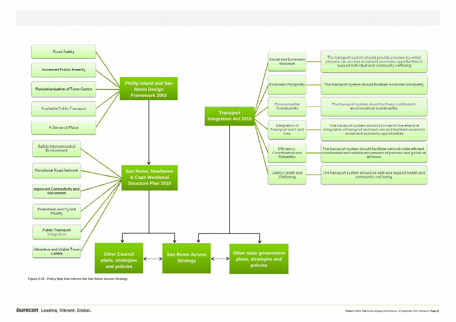
Figure 2-15 on the following page shows a diagram explaining how the San Remo Access Strategy relates to other key policies and strategies, and includes summaries of the major themes and objectives that inform the primary transport policies and strategies, such as the BCSC Asset and Infrastructure Management Plans.
2.6.1 Phillip Island and San Remo Integrated Transport Plan
The Minister for Roads, Terry Mulder, announced on 18 October 2012 the development of an integrated transport plan for Phillip Island and San Remo.
The San Remo Access Strategy will help inform and guide the development of that integrated transport plan.
Project 233004 File Access Strategy Rev6 final.doc 02 September 2013 Revision 6 Page 21
Phillip Island and San Remo Design
Framework 2003
San Remo, Newhaven & Cape Woolamai
Structure Plan 2010
San Remo Access Strategy
Transport Integration Act 2010
Other Council plans, strategies
and policies
Other state government plans, strategies and
policies
Figure 2-15 - Policy Map that informs the San Remo Access Strategy

Project 233004 File Access Strategy Rev6 final.doc 02 September 2013 Revision 6 Page 22
To ensure that an integrated approach is adopted for the development of the Access Strategy, the issues that have been identified are organised into themes, rather than considering each issue in isolation. Using this approach, seven key themes have been identified. These key themes and a brief description of each are shown in Figure 3-1.
3 Key Transport Themes
Figure 3-1 - San Remo Access Strategy seven key themes
The use of sustainable transport in San Remo is hampered by poor facilities and public perception. This theme addresses the problems related to the use of sustainable transport modes.
Transport safety for all users is a concern within San Remo. This theme address issues related to transport safety of all modes along roads, at intersections and at other conflict points.
Connections through San Remo’s transport network are incomplete. This theme addresses transport connections for all modes into and around San Remo’s residential and commercial and activity areas.
San Remo’s road network has no clearly defined hierarchy, poor circulation and is car-dominated. This theme relates to effective management of the road network.
This theme relates to heavy vehicle movements into and around San Remo, as well as heavy vehicle parking facilities and congestion concerns.
San Remo’s population includes a high proportion of seniors. This theme relates to the specific requirements of the transport network needed to cater for the population, as well as the expected population growth in the future.
Semi-permanent residents, short term visitors and event traffic significantly increase the demands on San Remo’s transport network. This theme relates to catering for these additional requirements.

Project 233004 File Access Strategy Rev6 final.doc 02 September 2013 Revision 6 Page 23
This section presents a description of each of the issues identified, organised under the seven key transport themes. The table below lists the potential impacts of each issue along with the objectives that would be desirable to achieve.
It is important to note that each issue cannot be considered in isolation, as there are many sets of issues that will have an impact on each other. Related issues have been identified as part of this assessment.
1A – Senior population
Issue description There is a lack of transport infrastructure to support a senior population. This includes:
• Limited walking paths suitably designed to accommodate mobility scooters throughout the town; and
• Paths and crossing points that are not designed to cater for the mobility impaired, including mobility scooters.
Possible transport impacts
• Conflict between pedestrians and vehicles
• Limited accessibility and connectivity
• Increased risk of accidents involving senior citizens
Objective Create a non-discriminating transport network that provides for all users using all modes.
Related issues 1B, 2A, 2C, 3A, 3C, 3D, 4A, 4B, 4C, 4D, 5B, 5C
4 Transport Issues

Project 233004 File Access Strategy Rev6 final.doc 02 September 2013 Revision 6 Page 24
1B – Growing population
Issue description There is planned growth to the east of existing residential areas within San Remo. However;
• There are limited connections between ‘New’ and ‘Existing’ San Remo for all modes of transport; and
• There will be increased pressure on existing connections with new development.
Possible transport impacts
• Increased traffic demands and reduced amenity along existing local roads
• Increased conflict between various transport modes
• Delayed access by emergency vehicles to new residential areas
Objective Ensure San Remo’s new development areas are well connected to the existing town centre and are designed to facilitate the use of sustainable modes.
Related issues 1A, 3A, 3C, 4C, 4D, 5A
Project 233004 File Access Strategy Rev6 final.doc 02 September 2013 Revision 6 Page 25
2A – Intersection safety and performance
Issue description A number of intersections within San Remo that have been identified as having performance or safety issues. These intersections include:
• Back Beach Road / Marine Parade / Phillip Island Road;
• Bergin Grove / Marine Parade / Phillip Island Road;
• Shetland Heights Road / Back Beach Road / Davis Point Road;
• Potters Hill Road/Phillip Island Road;
• Mary Grove / Park Road (two intersections); and
• Panorama Drive / Phillip Island Road.
Concerns at these intersections include:
• Ambiguous right of way;
• Poor lines of sight;
• Lack of line marking; and
• Inadequate roundabout size.
Possible transport impacts
• Reduced safety and increased risk of crashes
• Reduced accessibility to and from San Remo
• Conflict between various modes of transport
Objectives Ensure optimum safety for all transport users at key intersections within San Remo.
Related issues 1A, 2C, 3A, 5A, 5C, 6B
2B – Road conditions
Issue description Sections of San Remo’s roads are in an unsatisfactory condition for the role they play, or are to play, within the transport network. This includes:
• Sections of Potters Hill Road and Shetland Heights Road being unsealed; and
• Sections of major vehicle routes lacking sealed shoulders and adequate road widths.
Possible transport impacts
• Reduced safety and increased risk of crashes
• Unsatisfactory road environment
Objectives Improve safety along San Remo’s road network and encourage vehicle travel along preferred routes.
Related issues 3A, 5A
Project 233004 File Access Strategy Rev6 final.doc 02 September 2013 Revision 6 Page 26
2C – Conflict with active transport
Issue description Within San Remo, cars, heavy vehicles and active transport modes conflict on the road network. This includes on-road, where no formal separation is provided, as well as at intersections, due to no crossing facilities.
Possible transport impacts
• Safety risk for active transport users
• Increased risk of crashes
Objectives Minimise conflict between various forms of transport within the network.
Related issues 1A, 2A, 3A, 3B, 3C, 4c, 4D, 5B, 5C, 6A, 7A
Project 233004 File Access Strategy Rev6 final.doc 02 September 2013 Revision 6 Page 27
3A – Connectivity between ‘Existing’ and ‘New’ San Remo
Issue description Due to the topography, undeveloped land parcels and existing transport network infrastructure, there is limited connection between ‘Existing’ and ‘New’ San Remo for vehicles.
Possible transport impacts
• Phillip Island Road required as a link for internal trips
• Local residential streets acting as connector roads
Objectives Ensure there is suitable connectivity between ‘Existing’ and ‘New’ San Remo for all transport modes.
Related issues 1A, 1B, 2A, 2B, 2C, 3C, 4C, 4D, 5A, 5B, 5C, 6A
3B – Vehicle circulation within the commercial and activity area
Issue description No clear circulation path or facilitated U-turn is provided within the western section of Marine Parade.
Possible transport impacts
• Increased delays due to additional vehicle manoeuvres
• Duplication of Marine Parade traffic due to lack of circulation
• Reduction in local amenity
• Conflict between private vehicles and pedestrians
Objectives To facilitate safe and easy movement within the commercial and activity area along Marine Parade.
Related issues 2C, 4C, 5A, 5B, 5C, 6A, 7A, 7B
3C – Poor connectivity within the active transport network
Issue description There is a limited and fragmented pedestrian footpath network and no cycle network within the township.
Possible transport impacts
• Lack of incentive for residents and visitors to utilise active transport modes in San Remo
• Higher car dependency
Objectives A safe, connected transport network for all active transport users.
Related issues 1A, 1B, 2C, 3A, 3D, 4B, 4C, 4D, 5B, 5C, 6A

Project 233004 File Access Strategy Rev6 final.doc 02 September 2013 Revision 6 Page 28
3D – Inadequate walking trail connectivity
Issue description San Remo draws in tourism from its network of coastal walking paths. However, these paths do not form a complete route and are not connected to residential areas.
Possible transport impacts
• Lack of incentive for residents to use walking trails
• Reduced appeal of walking trails to tourists
Objective A safe, complete network of walking trails that link around and into San Remo
Related issues 1A, 3C, 4C, 5C

Project 233004 File Access Strategy Rev6 final.doc 02 September 2013 Revision 6 Page 29
4A – Poor perception of public transport services
Issue description San Remo residents and visitors are unaware of the extent of public bus services provided to, within and from the township.
Possible transport impacts
• Higher car dependency
• Reduced amenity within the commercial and activity centre in particular
• Reduced occupancy of bus services resulting in a reduction in the viability of such services
Objectives To ensure public bus services are visible and utilised by residents and visitors alike.
Related issues 1A, 4B, 5B
4B – Lack of public transport user facilities
Issue description Bus stop locations are difficult to access by foot, lack basic infrastructure and key stops in the vicinity of Marine Parade do not appropriately cater to the needs of users (e.g. toilet and drop-off facilities).
Possible transport impacts
• Difficult for pedestrians to access local bus stops, particularly those with mobility concerns
• Reduced utilisation of bus services
• Increased car dependency
Objectives To ensure the provision of suitable facilities and infrastructure which encourage the use of public transport.
Related issues 1A, 3C, 4A, 4C, 5B
4C – Pedestrian facilities and environment
Issue description San Remo has a limited and incomplete pedestrian footpath network, which includes no crossing facilities.
Possible transport impacts
• Pedestrian environment is unwelcoming
• Conflict between pedestrians and vehicles
• A car-dominated township
Objectives To provide a high quality and well-connected pedestrian network which encourages walking within San Remo.
Related issues 1A, 1B, 2C, 3A, 3B, 3C, 3D, 4B, 4D, 5B, 5C, 6A
Project 233004 File Access Strategy Rev6 final.doc 02 September 2013 Revision 6 Page 30
4D – Cycle paths and end-user facilities
Issue description No on or off-road dedicated cycle paths and very limited end-user facilities.
Possible Transport Impacts
• Cycling environment is unwelcoming
• Conflict between cyclists and vehicles
• A car-dominated township
Objectives To develop designated cycle paths and end-user facilities within the township to promote cycling as a viable transport mode.
Related issues 1A, 1B, 2C, 3A, 3C, 4C, 5B, 5C
Project 233004 File Access Strategy Rev6 final.doc 02 September 2013 Revision 6 Page 31
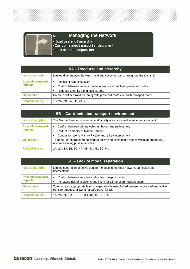
5A – Road use and hierarchy
Issue description Limited differentiation between local and collector roads throughout the township.
Possible transport impacts
• Inefficient road circulation
• Conflict between various modes of transport due to no preferred routes
• Reduced amenity along local streets
Objectives Create a defined road hierarchy with preferred routes for each transport mode.
Related issues 1B, 2A, 2B, 3A, 3B, 7A, 7B
5B – Car-dominated transport environment
Issue description The Marine Parade commercial and activity area is a car-dominated environment.
Possible transport impacts
• Conflict between private vehicles, buses and pedestrians
• Reduced amenity of Marine Parade
• Congestion along Marine Parade and at key intersections
Objectives To open-up the transport network to active and sustainable modes whilst appropriately accommodating private vehicles.
Related issues 1A, 2C, 3A, 3B, 3C, 4A, 4B, 4C, 4D, 5C, 6A
5C – Lack of modal separation
Issue description Limited separation of active transport modes in the road network, particularly at intersections.
Possible transport impacts
• Conflict between vehicles and active transport modes
• Increased risk of accidents and injury for all transport network users
Objectives To ensure an appropriate level of separation is established between motorised and active transport modes, allowing for safe travel for all.
Related issues 1A, 2A, 2C, 3A, 3B, 3C, 3D, 4C, 4D, 5B, 7A

Project 233004 File Access Strategy Rev6 final.doc 02 September 2013 Revision 6 Page 32
6A – Seasonal demands on the transport network
Issue description San Remo attracts a range of tourists, from school students attending the pelican feeding along the foreshore, to temporary residents staying in holiday homes for extended periods. During peak times, San Remo’s residential population can double to approximately 2,000 residents. Including visitors, approximately 5,000 people can be located in San Remo at one time.
Possible transport impacts
• Increased demand on the local transport network (particularly in the vicinity of Marine Parade, the foreshore and intersections linking San Remo with Phillip Island Road)
• Increased conflict between pedestrians and vehicles along Marine Parade
• Increased risk of crashes at intersections with Phillip Island Road and Marine Parade
• Reduced accessibility to Phillip Island Road and Marine Parade by local traffic
Objective Ensure San Remo’s transport network can cater for the seasonal variation in demand upon its network.
Related issues 2C, 3A, 3B, 3C, 4C, 5B, 6B
6B – Phillip Island event traffic
Issue description San Remo is directly affected by special event traffic using Phillip Island Road.
Possible transport impacts
• A reduction in the level of accessibility to and from San Remo
• Increased driver frustration resulting in risky driver behaviours
• Increase delays for emergency vehicles
Objective To ensure that San Remo’s internal transport network is not dependant on Phillip Island Road and that safe access to and from San Remo is maintained during special events on Phillip Island.
Related issues 2A, 6A
Project 233004 File Access Strategy Rev6 final.doc 02 September 2013 Revision 6 Page 33
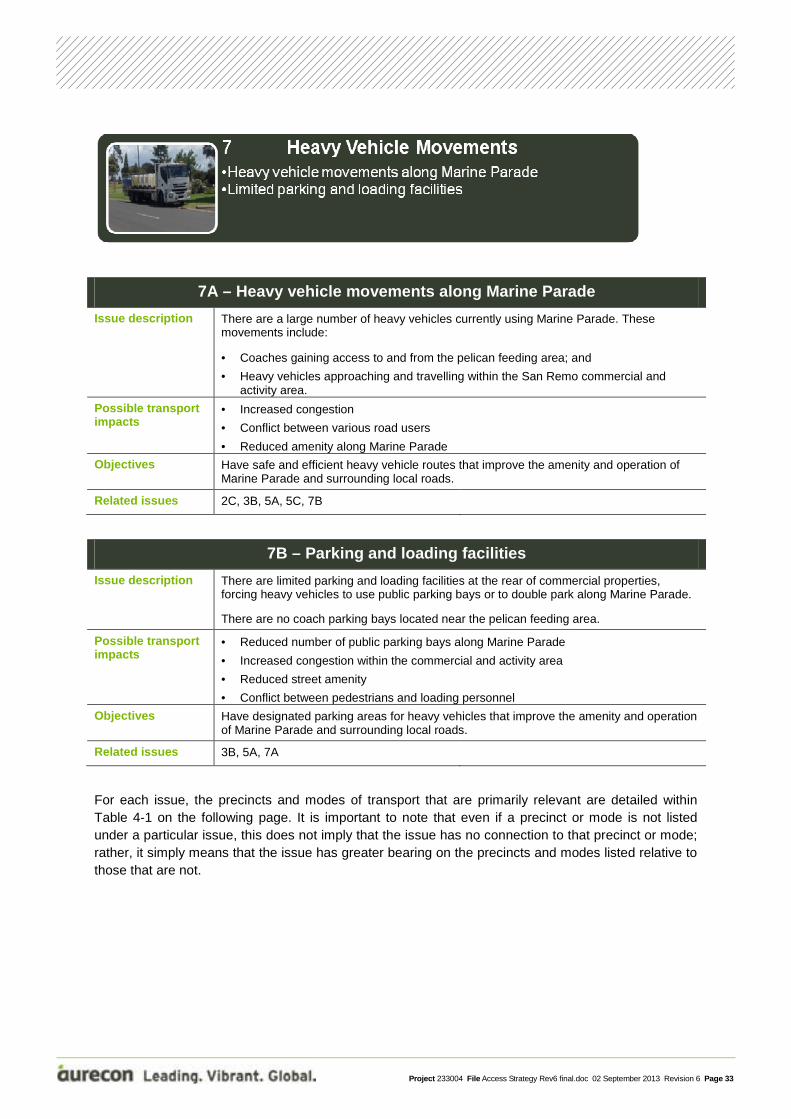
7A – Heavy vehicle movements along Marine Parade
Issue description There are a large number of heavy vehicles currently using Marine Parade. These movements include:
• Coaches gaining access to and from the pelican feeding area; and
• Heavy vehicles approaching and travelling within the San Remo commercial and activity area.
Possible transport impacts
• Increased congestion
• Conflict between various road users
• Reduced amenity along Marine Parade
Objectives Have safe and efficient heavy vehicle routes that improve the amenity and operation of Marine Parade and surrounding local roads.
Related issues 2C, 3B, 5A, 5C, 7B
7B – Parking and loading facilities
Issue description There are limited parking and loading facilities at the rear of commercial properties, forcing heavy vehicles to use public parking bays or to double park along Marine Parade.
There are no coach parking bays located near the pelican feeding area.
Possible transport impacts
• Reduced number of public parking bays along Marine Parade
• Increased congestion within the commercial and activity area
• Reduced street amenity
• Conflict between pedestrians and loading personnel
Objectives Have designated parking areas for heavy vehicles that improve the amenity and operation of Marine Parade and surrounding local roads.
Related issues 3B, 5A, 7A
For each issue, the precincts and modes of transport that are primarily relevant are detailed within Table 4-1 on the following page. It is important to note that even if a precinct or mode is not listed under a particular issue, this does not imply that the issue has no connection to that precinct or mode; rather, it simply means that the issue has greater bearing on the precincts and modes listed relative to those that are not.

Project 233004 File Access Strategy Rev6 final.doc 02 September 2013 Revision 6 Page 34
Table 4-1 - Key themes and issues
Key themes Issues
Relevant precincts Relevant modes
‘Exi
stin
g’ S
an
Rem
o
‘New
’ San
Rem
o
Bus
es &
E
mer
genc
y V
ehic
les
Tax
is
Ped
estr
ians
Cyc
lists
Sco
oter
s
Priv
ate
mot
oris
ed
Fre
ight
1 Growth & Demographics
1A Senior population � � � � � � � �
1B Growing population � � � � � � � �
2 Transport Safety
2A Intersection safety and performance
� � � � � � � � �
2B Road conditions � � �
2C Conflict with active transport
� � � � � � � � �
3 Connectivity
3A Connectivity between ‘Existing’ and ‘New’ San Remo
� � �
3B Vehicle circulation within the commercial and activity area
� � � � �
3C Poor connectivity within the active transport network
� � � � � �
3D Inadequate walking trail connectivity
� � �
4 Sustainable Transport
4A Poor perception of public transport services
� � � �
4B Lack of public transport user facilities
� � � � �
4C Pedestrian facilities and environment
� � �
4D Cycle paths and end-user facilities
� � �
5 Managing the Network
5A Road use and hierarchy � � � � �
5B Car-dominated transport environment
� � � � �
5C Lack of modal separation � � � � � � � � �
6 Tourism 6A
Seasonal demands on the transport network
� � � � � � �
6B Phillip Island event traffic � � � � � � �
7 Heavy Vehicle Movements
7A Heavy vehicle movements along Marine Parade
� � � � �
7B Parking and loading facilities
� � � � � � �

Project 233004 File Access Strategy Rev6 final.doc 02 September 2013 Revision 6 Page 35
Aurecon has developed a series of visions for transport within San Remo relating to each of the key themes and issues identified. To ensure progress towards the San Remo community’s wider aspirations, these visions are framed to be consistent with local government objectives outlined within documents such as:
• The Phillip Island and San Remo Design Framework 2003; and • The San Remo, Newhaven and Woolamai Structure Plan 2010.
In addition, consistency between an Access Strategy for San Remo and the Transport Integration Act’s transport system objectives will help to ensure that Council fulfils its obligation to align with this document.
5 Transport Vision
Figure 5-1 - Transport vision guiding documents

Project 233004 File Access Strategy Rev6 final.doc 02 September 2013 Revision 6 Page 36

Project 233004 File Access Strategy Rev6 final.doc 02 September 2013 Revision 6 Page 37
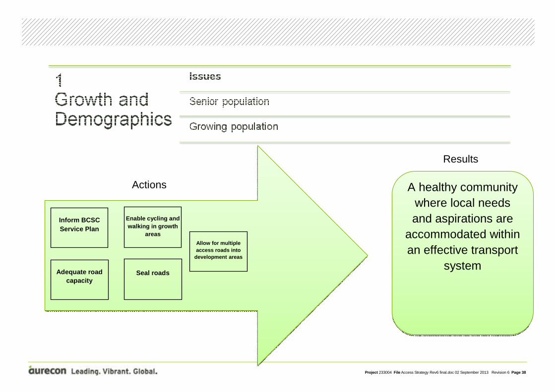
6.1 Introduction We have developed the action plans to respond to the themes and issues identified in this study. An additional theme, ‘Managing the Access Strategy’, was added to ensure the Strategy is kept alive and aspirations and action plans remain appropriate and up-to-date. This additional action plan theme, can be seen along with the other seven themes in Figure 6-1.
Figure 6-1 - Action Plan themes
6.2 Action Plan Format Each Action Plan has a summary page that captures:
• Issues associated with the theme; • The transport vision; and • A summary of recommended actions.
Following the summary page, details of each action are provided.
Many actions are related to multiple themes. These actions have each been listed under the major theme to which they relate.
6 Action Plans
Project 233004 File Access Strategy Rev6 final.doc 02 September 2013 Revision 6 Page 38
Inform BCSC Service Plan
A healthy community where local needs and aspirations are
accommodated within an effective transport
system
Enable cycling and walking in growth
areas
Seal roads Adequate road capacity
Allow for multiple access roads into
development areas
Actions
Results

Project 233004 File Access Strategy Rev6 final.doc 02 September 2013 Revision 6 Page 39
Action 1-1: Inform the BCSC Service Asset Management Plan
BCSC is currently updating its Service Asset Management Plan, a strategic document that guides the management of Council’s infrastructure. Based on the issues identified in San Remo we recommended that the Plan include or support the following actions:
• Continue to roll-out improvements of existing footpaths to achieve Disability Discrimination Act (DDA) compliance.
Continue to audit footpaths across the shire to ensure compliance with DDA. We recommend that the plan should prioritise implementation of upgrades to take into account the paths’ relative importanance in the pedestrian network. Our investigation of existing conditions in San Remo identified Marine Parade east of Bergin Grove as a high priority location for upgrade.
• Continued improvements to footpath amenity.
The Plan will continue to support the installation of facilities such as seating at rest points, toilets and drinking fountains to improve pedestrian and cyclist amenity. We recommend that BCSC develop and document guidelines to provide transparent direction to both Council officers and the community when considering the need for amenity upgrades. Guidelines may be related to:
- Challenging topography; - Tourist destinations (scenic lookouts etc); and - Community requests.
• Improved access to bus stops.
Expand the Service Asset Management Plan to include access to public transport facilities, including: - Investigate providing footpaths to existing bus stops; - Develop a plan to ensure appropriate pedestrian access to all bus stops; and - Investigate the potential to provide a V/Line passenger drop-off/pick-up and waiting area
for cars in the vicinity of the V/Line bus stops on Marine Parade.
• Introduction of mobility scooter recharge points.
Expand the Service Asset Management Plan to acknowledge the use of electric mobility scooters, including: - Investigation of potential locations for recharge points for the community. High priority
sites for provision of recharge points include: o Marine Parade; and o Foreshore area.
- Develop a policy to guide the provision of electric recharge points within San Remo.
Action 1-2: Ensure growth areas are designed to facilitate sustainable modes
We recommend that BCSC develop an active and sustainable transport guideline checklist in line with the existing planning scheme, to ensure that future developments incorporate the use of sustainable transport (cycling and walking). Developers and Council officers would use this guideline to ensure that requirements under the planning scheme are clearly understood and included in the design of new developments. As part of the application process, this procedure would require developers to adequately demonstrate how new residential areas will facilitate active and sustainable transport within, to and from developments.
Project 233004 File Access Strategy Rev6 final.doc 02 September 2013 Revision 6 Page 40
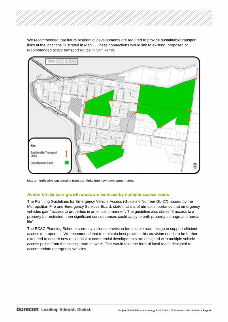
We recommended that future residential developments are required to provide sustainable transport links at the locations illustrated in Map 1. These connections would link to existing, proposed or recommended active transport routes in San Remo.
Map 1 – Indicative sustainable transport links into new development area
Action 1-3: Ensure growth areas are serviced by multiple access roads
The Planning Guidelines for Emergency Vehicle Access (Guideline Number GL-27), issued by the Metropolitan Fire and Emergency Services Board, state that it is of utmost importance that emergency vehicles gain “access to properties in an efficient manner”. The guideline also states “if access to a property be restricted, then significant consequences could apply to both property damage and human life”.
The BCSC Planning Scheme currently includes provision for suitable road design to support efficient access to properties. We recommend that to maintain best practice this provision needs to be further extended to ensure new residential or commercial developments are designed with multiple vehicle access points from the existing road network. This would take the form of local roads designed to accommodate emergency vehicles.

Project 233004 File Access Strategy Rev6 final.doc 02 September 2013 Revision 6 Page 41
Action 1-4: Ensure there is adequate road capacity to support anticipated population growth
The expected residential developments within San Remo will lead to an increase in traffic volumes in the road network. Council will need to ensure that the road network can effectively manage this increased demand.
To do this, we recommend that:
1. Council to recognise primary vehicle routes used by residents and enable necessary upgrades to be implemented accordingly. Identified existing main vehicle routes can be seen in Map 2.
2. Council recognise the existing limitations and constraints for east west movements between ‘Existing’ and ‘New’ San Remo, particularly at times when Phillip Island Road carries heavy traffic.
Council will carry out a study to identify local roads that could be extended to link between existing and future development areas. We recommend that Council create multiple east-west routes through the town. These routes should consist of a local road network that is designed for low vehicle speeds and traffic volumes. This will ensure that the roads can accommodate the increased traffic from proposed developments without sacrificing the amenity of existing local roads. A staggered approach to the design of the road network would ensure additional traffic is dispersed into multiple connecting routes through the town. We also recommend that no straight or direct road link be created between two identified collector roads (as per Map 2). We recommend against a single east-west thoroughfare between Potters Hill Road and Back Beach Road via Bonwick Avenue or any other local road. In support of this, we recommend that Council investigate access into proposed development areas from:
• Anderson Street; • Small Court; • Bonwick Avenue; • San Remo Parade • Panorama Drive; and • Back Beach Road

Project 233004 File Access Strategy Rev6 final.doc 02 September 2013 Revision 6 Page 42
Map 2 – Existing and Potential Future vehicle Links
Action 1-5: Seal Shetland Heights Road and Potters Hill Road
Council will investigate sealing the unsealed sections of Shetland Heights Road and Potters Hill Road to improve road safety. This should be done using developer contributions where possible. Further investigation will be needed to determine the acceptable sealed standard required and the inclusion of pathways.

Project 233004 File Access Strategy Rev6 final.doc 02 September 2013 Revision 6 Page 43
Advocate for access improvements
A transport system that is safe for all
users. Improve
intersections
Actions
Results

Project 233004 File Access Strategy Rev6 final.doc 02 September 2013 Revision 6 Page 44
Action 2-1: Review existing advocacy work with VicRoads regarding Phillip Island Road
Phillip Island Road performs multiple functions, especially in proximity to San Remo. The road is a state arterial providing the only road link to San Remo, as well as Phillip Island. We recommend that council review its advocacy plan with VicRoads regarding the role of Phillip Island Road, as well as the access arrangements at key intersections, including:
• Back Beach Road / Marine Parade / Phillip Island Road; • Bergin Grove / Marine Parade / Phillip Island Road; • Panorama Drive / Phillip Island Road; and • Potters Hill Road/Phillip Island Road.
The advocacy plan should include a proposal to reduce the posted speed limit along Phillip Island Road, east of Potters Hill Road, from 100km/hr to 60km/hr, and to investigate suitable controlled intersections providing access to and from Phillip Island Road, assisting movements into and out of San Remo.
Council should consider the requirements stated in the VicRoads Traffic Engineering Manuals (TEM) – Volume 1, as part of this advocacy plan.
The manual outlines that:
• Roundabouts are an unlikely or inappropriate form of control at the intersection of state arterial roads (Phillip Island Road) and local streets (both collector and purely local); and
• Traffic signals may be an appropriate form of control at the intersection of state arterial roads (Phillip Island Road) and local collector streets.
The TEM also outlines what conditions have to be met to justify the installation of traffic signals:
• For isolated communities with a population of less than 10,000 residents, the minimum traffic volume along a major road will be 420 vehicles per hour (two-way) and minor roads 140 vehicles per hour (two-way) over any four hour period on an average day; or
• Five or more reported casualty crashes over five years which may be eliminated by traffic signals. In exceptional cases where no single guideline is satisfied, but where the volumes are 80% of the requirement, VicRoads may consider upgrading the intersection to traffic signal control.
To identify which intersections meet the Vicroads requirements for upgrade to traffic signals it is recommended that Council collect traffic counts at each of the intersections listed above on an ‘average’ day and also on a special event day when Phillip Island Road has a high traffic volume. In addition it is recommended that Council collect data on the frequency of high volume traffic days along Phillip Island Road to support their advocacy with VicRoads.
This action will contribute to the development of the Phillip Island Integrated Transport Plan (PIITP) being prepared in the second half of 2013. The PIITP will consider the operation of all intersections along Phillip Island Road and identify which intersections should be considered for upgrade.
Action 2-2: Review and improve safety at key local road intersections
We recommend that Council consider VicRoads crash data and information gathered at the San Remo Access Strategy Community Workshop (as per Appendix 3 of Project Brief), to identify and improve safety at key local road intersections.

Project 233004 File Access Strategy Rev6 final.doc 02 September 2013 Revision 6 Page 45
Based on preliminary investigations, the following intersections and suggested improvements include, but are not limited to:
• Shetland Height Road/Back Beach Road intersection: This intersection provides a key link for vehicles and pedestrians and requires an upgrade to improve safety for all users. The suggested upgrade could include:
- The installation of a traffic island on Back Beach Road (north) to assist pedestrian movements and prevent vehicles cutting across the intersection.
• Mary Grove/Park Road intersections:
Council is to investigate safety improvement options for the two intersections of Mary Grove and Park Road. Safety improvements could include:
- Removing the section of fencing that restricts line of sight and movement around the roundabout;
- Closing the small section of Mary Grove between the two intersections to vehicular traffic and forming a pedestrian and bicycle path through this link; and
- Installing a footpath along Mary Grove.

Project 233004 File Access Strategy Rev6 final.doc 02 September 2013 Revision 6 Page 46
A well-connected and comprehensible
transport network which allows for easy
movement
Improve vehicle circulation
Actions
Results

Project 233004 File Access Strategy Rev6 final.doc 02 September 2013 Revision 6 Page 47
Action 3-1: Improve vehicle circulation through ‘Existing’ San Remo and Marine Parade
This study has identified poor vehicle circulation in ‘Existing’ San Remo and surrounding areas. During peak holiday season, this results in congestion along Marine Parade and compromised vehicle and pedestrian safety throughout the activity area. With increased population and tourism growth in the area, this problem will continue to worsen and further reduce road safety and amenity throughout ‘Existing’ San Remo.
The action involves the investigation of, but not limited to, the following circulation improvement:
• The installation of a roundabout at the western end of Marine Parade.

Project 233004 File Access Strategy Rev6 final.doc 02 September 2013 Revision 6 Page 48
A transport network
where active and sustainable modes
are accessible, attractive, encouraged and embraced by the
community
Advocate for bus stops
Pedestrian priority on Marine Parade
Implement Bicycle Infrastructure
Plan
Implement Pathways Plan
Actions
Results

Project 233004 File Access Strategy Rev6 final.doc 02 September 2013 Revision 6 Page 49
Action 4-1: Review advocacy plan with Public Transport Victoria (PTV) regarding improved bus stop facilities, access, awareness and services
We recommend Council review its advocacy plan with PTV to provide improved bus stop facilities and services, including advocating for the installation of:
• Bus stop shelters; • Bus stop seating (can be combined with shelters); and • Real time bus information at the major stops on Marine Parade and Phillip Island Road. The advocacy plan should also include: • The installation of maps at major bus stops on Marine Parade and Phillip Island Road; • Making bus stops more visible and attractive; • The preparation of a communication strategy to inform the community about regular and event
public transport services; and • A review of existing bus services and timetables to better cater for the requirements of the wider
Bass Coast Area.
Action 4-2: Investigate ways to improve pedestrian priority along Marine Parade
We recommend council investigate pedestrian priority measures along Marine Parade to ensure a safe and welcoming pedestrian environment.
These measures could include:
• The installation of multiple safe crossing points (raised and coloured) to connect activities on separate sides of Marine Parade;
• The installation of a wider footpath along Marine Parade, east of Bergin Grove to match the existing provision to the west; and
• The preparation of an advocacy plan for VicRoads to reduce the speed limit along Marine Parade to 20kph, allowing Marine Parade to become a Shared Zone.
The location of pedestrian priority measures can be seen in Map 4.

Project 233004 File Access Strategy Rev6 final.doc 02 September 2013 Revision 6 Page 50
Map 4 – Marine Parade pedestrian priority
Action 4-3: Continue the implementation of the BCSC Pathways Plan
The BCSC Pathways Plan identifies gaps in the existing footpath network. We recommend that Council continue to implement this plan, including investigating locations for the installation of new footpath links within San Remo and preparing an upgrade plan taking into account the path’s relative importance within the pedestrian network.
Our preliminary investigations have identified a number of specific links requiring additional footpath connections. These can be seen in Map 5.

Project 233004 File Access Strategy Rev6 final.doc 02 September 2013 Revision 6 Page 51
Map 5 – Existing proposed and required footpaths
Action 4-4: Continue the implementation of the BCSC Bicycle Infrastructure Action Plan
The BCSC Bicycle Infrastructure Plan identifies gaps in the existing bicycle path network. We recommend that Council continue to implement this plan, including investigating locations for the installation of bicycle paths in San Remo and considering the location of proposed paths in regards to desire lines, geographical contours and the location of key attractors such as the school, scenic points and commercial and activity areas.
Locations recommended for consideration could include, but are not limited to:
• Shetland Heights Road; • Back Beach Road; • Genista Street; and • Marine Parade. A shared user path has been approved for construction along Potters Hill Road, which would link to the proposed paths.
We also recommend that Council extend the BCSC Bicycle Infrastructure Plan to include:
- The development of warrants that outline the triggers for the provision of bicycle parking and other end-user facilities; and
- Guidelines for implementation of bicycle parking, such as: o Provision of shelter; o Proximity to activities; o Visibility; and o Design.

Project 233004 File Access Strategy Rev6 final.doc 02 September 2013 Revision 6 Page 52
Recommended locations for bicycle parking loops in San Remo are Marine Parade and the foreshore area, as shown in Map 6.
Map 6 – Recommended bicycle paths and bike storage locations

Project 233004 File Access Strategy Rev6 final.doc 02 September 2013 Revision 6 Page 53
Traffic calming
A clear network hierarchy that caters appropriately for all modes of transport
within a safe transport environment
Actions
Results

Project 233004 File Access Strategy Rev6 final.doc 02 September 2013 Revision 6 Page 54
Action 5-1: Investigate traffic calming measures on minor local roads
We recommend Council investigate traffic calming measures to reduce through traffic on unsuitable roads. Areas which could benefit from reduced through traffic include:
• Commercial and activity areas: - Marine Parade.
• Streets in close proximity to the school: - Bergin Grove; - Thomas Grove; - Ocean Grove; - Edgar Road; - Hazelwood Road; and - Wynne Road.
• Residential areas: - Genista Street (west).
Traffic calming measures could include:
• A reduction in speed limits (may require the preparation of an advocacy plan to VicRoads); • Speed humps; • Kerb extensions; and • Chicanes.

Project 233004 File Access Strategy Rev6 final.doc 02 September 2013 Revision 6 Page 55
A vibrant, welcoming and sustainable place
where transport infrastructure supports
and enhances the tourist experience
Improve way-finding
Actions
Results

Project 233004 File Access Strategy Rev6 final.doc 02 September 2013 Revision 6 Page 56
Action 6-1: Audit way-finding and signage for tourists
We recommend Council audit existing way-finding measures and investigate improvements to better manage movements for all modes. The way-finding should:
• Control entry points into and out of town (once preferred entry and exit points have been identified); and
• Assist pedestrians and cyclists to move around the town.

Project 233004 File Access Strategy Rev6 final.doc 02 September 2013 Revision 6 Page 57
Adopt circulation route
A transport network where heavy vehicles
have appropriate access, parking and
loading facilities, having minimal impact
on other road users and the environment
Formalise parking
Investigate loading areas
Actions
Results

Project 233004 File Access Strategy Rev6 final.doc 02 September 2013 Revision 6 Page 58
Action 7-1: Adopt preferred coach circulation route
We recommend Council investigate a preferred coach circulation route.
Preliminary investigations have indicated a preferred circulation route that would utilise Marine Parade and an existing car park, located to the north of Marine Parade.
Action 7-2: Formalise coach parking area
We recommend Council formalise the coach parking area. This formalisation includes the repainting of parking bays and providing way-finding for visitors to and from parking areas.
Preliminary investigations have indicated a location for the coach parking area within an existing car park, to the north of Marine Parade. This space would allow for easy access to the commercial and activity areas and ensure no coaches are parked along the southern section of Marine Parade. Additionally, this location would allow for coaches to turn around and avoid any unnecessary manoeuvring.
The identified circulation path and preferred location of the coach parking area can be seen in Map 7.
Map 7– Identified coach circulation route and parking area
Action 7-3: Investigate loading areas
We recommend Council investigate the installation of a laneway to run at the rear of the businesses along Marine Parade. This laneway would provide loading and rear access to businesses and reduce the number of heavy vehicles traversing and stopping along Marine Parade and Bergin Grove.

Project 233004 File Access Strategy Rev6 final.doc 02 September 2013 Revision 6 Page 59
Set Up Update
Actions within the Access Strategy are carried out and the
status of actions and issues are reviewed
regularly and transparently
Monitor
Actions Results

Project 233004 File Access Strategy Rev6 final.doc 02 September 2013 Revision 6 Page 60
Action 8-1: Set up Access Strategy Implementation Group
It is important to manage the implementation of the Access Strategy. For this reason, we recommend forming a group to implement and manage actions in the Access Strategy now and into the future. This would include:
• Identify who should be included in the Implementation Group and from which sections of Council; • Prepare a charter setting out the role and responsibilities of the Group; • Determine the process for establishing Key Priorities on an annual basis; • Determine the process for establishing KPI’s on an annual basis; and • Identify the Chair of the Group (this could change annually). This person should report to the
elected Councilors.
Monitoring of actions
One of the roles of the Implementation Group would be to monitor the status of actions set out within the Access Strategy on a quarterly basis to identify whether actions are:
• Complete; • Ongoing; • Partially complete; • Planned for next quarter; or • Awaiting funding.
Review and update Access Strategy, including key priorities annually
The Access Strategy is intended to be a living document for the period it covers namely 2013 to 2028. However, policy and approaches to transport planning as well as transport technologies are continuously evolving. For this reason, we recommend that the strategy be reviewed annually to identify major changes to the Action Plans of the Access Strategy and to include recommendations for additional actions if necessary.

Project 233004 File Access Strategy Rev6 final.doc 02 September 2013 Revision 6 Page 61
7.1 Methodology The Access Strategy has identified a large number of actions; however resources available to Council to implement these actions in any given financial year are limited. Aurecon, in conjunction with Council, has developed a prioritisation framework to guide Council in implementing the actions of the strategy.
The adopted prioritisation methodology seeks to evaluate each action against the following criteria:
• Access improvement; • Specific to San Remo; • Affected population; and • Safety.
Each category comprises three evaluation bands and are set out in Table 7-1.
Table 7-1 - Evaluation bands – scoring criteria
Access Improvement
1 Action will result in improved access amenity of existing infrastructure
2 Action will result in improved existing access infrastructure
3 Action will result in new access infrastructure
Specific to San Remo
1 Action is applicable to whole of BCSC area
2 Action is specific to Anderson Peninsula and Phillip Island communities
3 Action is specific to the needs of San Remo
Affected Population
1 Action improves accessibility for a select group
2 Action improves accessibility for the existing population
3 Action increases access capacity to support future population growth
7 Prioritisation

Project 233004 File Access Strategy Rev6 final.doc 02 September 2013 Revision 6 Page 62
Safety
1 Action will have no impact on perceived and actual safety issues
2 Action will potentially improve perceived and actual safety issues
3 Action will lead to resolving specific safety issues
In addition, weightings were applied to each of the scoring categories to reflect Aurecon and Council’s view of the importance of each category to the Access Strategy. The adopted weightings are set out in Table 7-2.
Table 7-2 - Assessment category weightings
Criteria Weighting (%)
Access improvement 30%
Specific to San Remo 30%
Population affected 20%
Safety 20%
For the purpose of prioritisation, actions have been designated as high, medium, or low as defined below in Table 7-3.
Table 7-3 - Prioritisation of actions
Priority Score Range
High 2.5 or greater
Medium 1.5 to 2.4
Low/ongoing 1.4 or less
The action evaluation matrix can be seen in Table 7-4 below:

Project 233004 File Access Strategy Rev6 final.doc 02 September 2013 Revision 6 Page 63
Table 7-4 - San Remo Access Strategy action evaluation matrix
Key themes Actions
30% 30% 20% 20% 100%
Prio
rity
Acc
ess
Impr
ovem
ent
Spe
cific
to
San
Rem
o
Affe
cted
P
opul
atio
n
Saf
ety
Tot
al s
core
1 Growth and Demographics
1-1 Inform the Service Asset Management Plan 2 1 2 1 1.5 Medium
1-2 Ensure growth areas are designed to facilitate sustainable modes 3 1 3 2 2.2 Medium
1-3 Ensure growth areas are serviced by multiple access roads 1 1 3 2 1.6 Medium
1-4 Ensure there is adequate road capacity to support population growth 3 3 3 2 2.8 High
1-5 Seal Shetland Heights Road and Potters Hill Road 2 3 3 3 2.7 High
2 Transport Safety
2-1 Review advocacy work with VicRoads regarding Phillip Island Road 2 2 2 2 2.0 Medium
2-2 Review and improve safety at key intersections 2 2 2 3 2.2 Medium
3 Connectivity 3-1 Improve vehicle circulation through ‘Existing’ San Remo and Marine Parade 3 3 3 2 2.8 High
4 Sustainable Transport
4-1 Review advocacy plan work with Public Transport Victoria (PTV) regarding improved bus stop facilities
1 1 2 1 1.2 Low
4-2 Investigate ways to improve pedestrian priority along Marine Parade 2 3 3 3 2.7 High
4-3 Continue implementation of the BCSC Pathways Plan 2 1 3 2 1.7 Medium
4-4 Continue implementation of Bicycle Infrastructure Action Plan 3 1 3 2 2.2 Medium
5 Managing the Network 5-1 Investigate traffic calming measures on minor local roads 1 1 1 2 1.2 Low
6 Tourism 6-1 Audit wayfinding and signage for tourists 1 2 1 1 1.3 Low
7 Heavy Vehicle Movements
7-1 Adopt preferred coach circulation route 1 2 1 2 1.5 Medium
7-2 Formalise coach parking area 1 2 1 2 1.5 Medium
7-3 Investigate loading areas 2 3 1 2 2.1 Medium

Project 233004 File Access Strategy Rev6 final.doc 02 September 2013 Revision 6 Page 64
8.1 Preamble The Action Plans considered identify each action as being high, medium or low priority. This priority rating provides guidance on a suitable timeframe for the implementation of individual actions. A second consideration is whether actions are independent to this strategy or will inform or impact other existing and future strategies developed by BCSC. A third consideration is potential funding and this criterion is not included in this assessment.
8.2 High Priority Actions We recommend that high priority actions be implemented within five years, subject to funding.
Based on the prioritisation outlined in the previous section, the high priority actions are outlined in Table 8-1.
Table 8-1 - High priority actions
Reference Action Total Score
1-4 Ensure there is adequate road capacity to support future population growth
2.8
1-5 Seal Shetland Heights Road and Potters Hill Road 2.7
3-1 Improve vehicle circulation through ‘Existing’ San Remo and Marine Parade
2.8
4-2 Investigate way to increase pedestrian priority along Marine Parade 2.7
8 Recommendations

Project 233004 File Access Strategy Rev6 final.doc 02 September 2013 Revision 6 Page 65
High Priority Actions in order of reference
Action 1-4 – Ensure there is adequate road capacity to support future population growth
This study has identified that the capacity of the existing roads to accommodate local movements between the residential areas in the east and the activity centre in the west can be limited, particularly when Phillip Island Road has heavy traffic. This capacity issue will worsen as San Remo grows and as traffic on Phillip Island Road also increases. Congestion increases could lead to further community frustration at peak times and delays for access by emergency vehicles.
This action has been developed to recognise and respond to issues for the local and arterial road capacity and includes two main components:
1. Council to recognise the existing primary vehicle routes used by residents and enable necessary upgrades to be implemented accordingly (Identified existing main vehicle routes can be seen in Map 2, page 42).
2. We recommend that Council create multiple routes running from east to west throughout the town. These routes should be designed to accommodate low vehicle speeds and small traffic volumes only. To facilitate this, Council need to investigate access into proposed development areas from:
• Anderson Street; • Small Court; • Bonwick Avenue; • San Remo Parade; • Panorama Drive; and • Back Beach Road
A single east west thoroughfare between Potters Hill Road and Back Beach Road via Bonwick Avenue or any other local road is not recommended to ensure the amenity on existing local roads is not sacrificed.
Action 1-5 – Seal Potters Hill Road and Shetland Heights Road
This study has identified the importance of sealing Shetland Heights Road and Potters Hill Road to address safety concerns pertaining to the existing poor road conditions. At present, these roads serve the sparsely populated outer areas of San Remo. However, the proposed residential development of Wallis Watson Abrahamson land will result in additional traffic along both of these roads.
The sealing of Potters Hill and Shetland Heights Road will open opportunities to investigate the addition of future bicycle paths and pedestrian footpaths along these roads.
Action 3-1– Improve vehicle circulation through ‘Existing’ San Remo and Marine Parade
This study has identified poor vehicle circulation in ‘Existing’ San Remo and surrounding areas. During peak holiday season, this results in congestion along Marine Parade and compromised vehicle and pedestrian safety throughout the activity area. With increased population and tourism growth in the area, this problem will continue to worsen and further reduce road safety and amenity throughout ‘Existing’ San Remo.
The action involves the investigation of, but not limited to, the following circulation improvement:
• The installation of a roundabout at the western end of Marine Parade.

Project 233004 File Access Strategy Rev6 final.doc 02 September 2013 Revision 6 Page 66
Action 4-2 – Investigate ways to improve pedestrian priority along Marine Parade
This study has identified that Marine Parade, the main activity area in San Remo is an environment dominated by cars, where pedestrian safety and amenity is compromised by limited crossing facilities, high vehicle speeds, and vehicle congestion.
The aim of this action is to ensure a welcoming and safe pedestrian environment along Marine Parade and recommends that Council investigate pedestrian priority measures along Marine Parade.
These measures include, but are not limited to:
• The installation of multiple safe crossing points (raised and coloured) to connect activities on either side of Marine Parade;
• The installation of a wider footpath along Marine Parade, east of Bergin Grove to match the existing provision to the west; and
• Prepare an advocacy plan for VicRoads to reduce the speed limit along Marine Parade to 20kph, allowing Marine Parade to become a Shared Zone.
This action is closely linked to action 3-1, ‘Improve circulation through ‘Existing’ San Remo’, which should be considered in conjunction.
8.3 Actions Informing Other Strategies A number of actions -while not identified as ‘high priority’- will impact the development and implementation of other BCSC strategies and plans. Because of this, these actions should be adopted and implemented in the near future, but may be implemented within a medium or low priority timeframe. These actions can be seen in Table 8-2.
Table 8-2 - Actions informing other strategies
Reference Action Total Score
1-1 Inform the Service Asset Management Plan 1.5
1-2 Ensure growth areas are designed to facilitate sustainable modes 2.2
1-3 Ensure growth areas are serviced by multiple access roads 1.6
2-1 Review advocacy work with VicRoads regarding Phillip Island Road 2.0
4-3 Continue implementation of the BCSC Pathways Plan 1.7
4-4 Continue implementation of the BCSC Bicycle Infrastructure Action Plan 2.2
8.4 Medium and Low Priority Actions We recommend that medium and low priority actions that are not informing other BCSC policies and strategies be progressed within a fifteen year time frame, subject to funding. These medium and low priority actions are listed below in Table 8-3 and Table 8-4.
The top scoring medium priority action, 2-2 – Improve safety at key intersections, is an ongoing action reviewed regularly by Council.

Project 233004 File Access Strategy Rev6 final.doc 02 September 2013 Revision 6 Page 67
Table 8-3 - Medium priority actions
Reference Action Total Score
2-2 Improve safety at key intersections 2.2
7-1 Adopt preferred coach circulation route 1.5
7-2 Formalise coach parking area 1.5
7-3 Investigate loading areas 2.1
Table 8-4 - Low priority actions
Reference Action Total Score
4-1 Review advocacy plan work with Public Transport Victoria (PTV) regarding improved bus stop facilities
1.2
5-1 Improve traffic calming measures on minor local roads 1.2
6-1 Improve wayfinding and signage for tourists 1.3

Appendix A Summary of Community submissions and responses
Summary of community submissions and responses
Subject Number of comments Related action Response
Opposition of Actions
Extension of Davis Point Road through to Bergin Grove and Woolamai Grove 19 Action 3-1
In consideration of the community response, and further consideration of the sensitive environmental and cultural conditions, the extension of Davis Point Road through to Woolamai Grove is no longer recommended as an option. This option has been removed from Action 3-1.
Extension of Bonwick Avenue through Keams Land and Potters Hill Road.
7 Action 1-3 and 1-4
The Access Strategy has applied best practice policy in recommending multiple access points into residential areas to ensure vehicles, including emergency vehicles, are able to easily access properties. However, the Strategy also acknowledges the value of maintaining the amenity of all local roads within San Remo. For this reason, the Access Strategy does not recommend that any one road become the primary connection between the eastern and western parts of the town.
The new Action 1-3 recommends multiple access points for the new development areas. This Action will work in conjunction with the new Action 1-4, which recommends multiple future and existing local roads be used to provide connections between east and west, regions of the town. Furthermore, it is recommended that these local roads be designed to support only low vehicle speeds and volumes.
Multiple east-west and north-south routes in the town will minimise impacts associated with traffic growth created by increased car ownership, change in demographics and additional development. This would limit the impact upon existing local roads such as Shetland Heights Road, Bonwick Avenue, Anderson Street, Small Court, Panorama Drive, Genista Street and Back Beach Road.
In addition, multiple actions (1-2, 4-3 and 4-4) are recommended to encourage walking and

Summary of community submissions and responses
Subject Number of comments Related action Response
cycling throughout the town. These actions will also help reduce the number of local car trips within the town.
Concern that sealing Shetland Heights Road will result in it becoming the main east-west route through San Remo.
2 Action 1-5
The Access Strategy acknowledges that Shetland Heights Road provides an existing east-west connection through San Remo. The recommended sealing of Shetland Heights Road and Potters Hill Road in Action 1-5, aims to improve the safety and amenity of these roads by:
• Reducing the risk of vehicles sliding or skidding; and
• Reducing the level of dust, therefore improving driver visibility and amenity in the area.
To ensure that Shetland Heights Road does not become the sole east west connection in the town, Actions 1-3 and 1-4 recommend multiple connections through the town and new developments. Furthermore, Action 2-1 now identifies the intersection of Potters Hill Road and Phillip Island Road as a key intersection in San Remo that needs to be considered in the advocacy work between Council and VicRoads.
Closing access to Phillip Island Road from Sam Remo Parade and Keams Crescent
1 Action 2-1
Any reference to closing the intersections of San Remo Parade/Phillip Island Road and Keams Crescents/Phillip Island Road have been removed from Action 2-1. However, it should be noted that the Phillip island Integrated Transport Study will further consider the operation of intersections along Phillip Island Road.
Providing footpaths beyond Penniwells Drive 1 Action 4-3
The recommended provision of footpaths along Shetland Heights Road would provide a safe alternative transport link in this part of San Remo. It is noted that the gradient along sections of Shetland Heights Road may be challenging for some pedestrians. However, Action 1-1 of the strategy recommends improved footpath amenity on challenging topography in the form of seats at rest points to further encourage pedestrians of all abilities.
Support of Actions
Improving the intersection of Back Beach Rd / Marine Parade / Phillip Island Road
8 Action 2-1
Extension of Bonwick Avenue 6 Action 1-3
Improved pedestrian and bike links through the town
6 Actions 4-3 and 4-4
Sealing Shetland Heights Road 5 Action 1-4
Sealing Potters Hill Road 3 Action 1-4
Improving the intersection of Bergin 3 Action 2-1

Summary of community submissions and responses
Subject Number of comments Related action Response
Grove / Phillip Island Road
Improving the intersection of Potters Hill Road / Phillip Island Road 3 Action 2-1
Roundabout at the western end of Marine Parade 3 Action 3-1
Improved footpaths/amenity along Marine Parade
3 Action 4-2
Relocating parking bays to the rear of Marine Parade shops 2 N/A
Traffic calming through Genista Street 2 Action 5-1
Improved footpaths along Shetland Heights Road 1 Action 4-3
Promote active transport on Shetland Heights and Panorama Drive 1
Actions 4-3 and 4-4
Improved pedestrian and bike access through Keams Land 1 Actions 4-3 and 4-
4
Improved footpaths links to Silverwater Resort 1 Action 4-3
Reducing speed limits to improve safety 1 Actions 4-2 and 5-
1
Traffic island at intersection of Back Beach Road / Davis Point Road / Shetland Heights Road
1 Action 2-2
Developing a new diagonal road from Phillip Island Road to Shetland Heights Road
1 N/A
Comments regarding the action priorities
Action 2-2 Improving safety at intersections should be high priority 1 Action 2-2
Both Council and Aurecon value safe design and recognise the importance of safety in planning the transport network. For this reason, safety has been identified as one of the key criteria when prioritising the actions within the strategy. However, it is important to note that this document is an “access” strategy. Therefore, the primary role of the document is to identify and prioritise actions that will improve the access and movement of people within San Remo. Thus, ‘access improvement ‘and actions ‘specific to San Remo’ have a higher weighting than ‘population affected’ and ‘safety’ criteria. It should be noted that a majority of the actions indirectly improve the safety of the transport network. For example, sealing roads or recommending the installation of a footpath to separate pedestrians from vehicles on the road.
Action 5-1 Improving traffic calming on local streets should be higher priority 1 Action 5-1
Actions 4-3 and 4-4 should be higher priority 1 Actions 4-3 and 4-
4
Comments related to issues outside the scope of the study
Phillip Island road duplication/two 5 N/A The project brief as prepared by Council in

Summary of community submissions and responses
Subject Number of comments Related action Response
lanes each way conjunction with the San Remo community specified a study area bordered by:
• Woolamai Grove on the west, • Oceanview Drive and Penniwells
Drive to the south; • Potters Hill Road to the east; and • Phillip Island Road to the north.
Phillip Island Road and the bridge connection between San Remo and Phillip Island were not included in this study area. However, the Phillip Island Integrated Transport Study will focus on the operation of the tourist road. As noted in Action 2-1, the San Remo Access Strategy will provide input into this study. It is important to note that Phillip Island Road is a state road and therefore managed by VicRoads. The San Remo Access Strategy is a Council document that will be used to guide the decision making process of Council. The Phillip Island Integrated Transport Study is a joint Council and State Government managed study that will inform not only Council but also State Government Authorities, such as VicRoads.
New bridge (increased number of lanes) to Phillip Island 4 N/A
Phillip Island traffic to bypass Phillip Island Road 3 N/A

Appendix B Community Consultation Report

1
What we heard at the…
San Remo Access Strategy Consultation Workshops
Bass Coast Shire Council
Workshops held on March 21 & 24, 2013
Recreation Centre, San Remo
_________________________________________________________

2
Table of Contents
PART A BACKGROUND & PROCESS 3
1 Introduction 3
2 Workshop Objectives 3
4 Participants and Attendance 3
4 Workshop Process 3
PART B THURSDAY EVENING WORKSHOP MARCH 21, 2013 5
1 Getting Started 5
2 Workshop Agreements 5
3 Welcome Cr Bradley Drew 6
4 Presentation – Ambulance Victoria 6
5 Initial Ideas, Issues & Questions 7
6 Deciding the Agenda 9
7 Issue: VicRoads, Tourist Road and Bridge 9
8 Issue: East – West Links 21
9 Issue: Others 29
10 Next Steps 30
11 Evaluation 30
PART C SUNDAY AFTERNOON WORKSHOP MARCH 24, 2013 33
1 Getting Started 33
2 Workshop Agreements 33
3 Welcome Cr Bradley Drew 34
4 Initial Ideas, Issues & Questions 34
5 Presentation - Council 34
6 Presentation – Ambulance Victoria & CFA 34
7 Questions & Answers 34
8 Discussion Key Topics in Access Strategy 34
9 Reports from Table Groups 51
10 Next Steps 51
11 Evaluation 51
Report prepared by Kimbra White, Kimbra White Consulting, April, 2013

3
PART A: BACKGROUND & PROCESS
1. Introduction
Bass Coast Shire Council has prepared a Draft Access Strategy for San Remo and is in the process
of seeking community comment on the Strategy before it is finally considered by Council for
adoption.
This Strategy includes “an assessment of the existing access conditions into and around San Remo,
aspirations for the future and recommended actions to achieve the transport vision for San Remo.”
As part of the consultation process on the Draft Access Strategy, Council convened two
workshops on Thursday evening March 21, 2013 and Sunday afternoon March24, 2013. Kimbra
White of Kimbra White Consulting was employed to facilitate both workshops and to prepare this
report on the findings from the workshops.
2. Workshop Objectives
The objective of the workshop was for the San Remo Community to provide feedback on the San
Remo Draft Access Strategy.
3. Participants and Attendance
These were open public workshops that had been advertised in the local newspaper. In addition
Council sent an invitation to everyone on the contact mailing lists from the previous consultation
activities on this topic and sent an invitation to all ratepayers in San Remo.
108 community members attended on Thursday evening and 100 on Sunday afternoon. Of these
about 20 people attended both sessions. In addition, four councillors attended on Thursday night:
Ward Councillor, Cr Bradley Drew; Mayor, Cr Clare Le Serve; Deputy Mayor, Cr Neil Rankin and
Cr Andrew Phillips. Cr Drew and Cr Le Serve attended on Sunday afternoon. Council’s CEO Alan
Bawden, Strategic Planning and Engagement Manager Jodi Kennedy, and Strategic Planning Co-
ordinator Shannon Davies attended both sessions. Lora Colussi from Aurecon (Access Strategy
author) attended both sessions.
4. Workshop Process
Initial plans were that both workshops would have an identical agenda. On the Thursday a process
was undertaken for the participants to identify the issues that were of most concern to them and
the facilitator used that list to set the agenda for the workshop. This lead to large and small
discussion at Thursday’s workshop on (1) the Phillip Island Tourist Road (assisted by the VicRoads
representative being in attendance) and (2) internal east- west road links.
Rather than repeat this agenda setting discussion on the Sunday, the Thursday night list was used
on the Sunday, with Sunday participants invited to add additional ideas.
A number of people in the evaluation on Thursday night said that they would have liked to have
covered more issues (that we didn’t get to all the issues in the report). In response to these
comments, the facilitator set up a series of topic tables for the discussion section of the Sunday

4
workshop so people could take part in a small group discussion on the topic of most interest to
them, with enough time to cover 2-3 topics. This provided the opportunity to cover more issues in
small groups than had been achieved on the Thursday evening. The evaluation from the Sunday
workshop shows that while some people enjoyed the small group conversations, a number of
people did not like the small groups and felt that they had been prevented from speaking to the
whole group about the important issues.
This photo of the agenda shows both the Thursday agenda with changes for Sunday marked in
green.
The remainder of this report is a record of the discussion at the two workshops.

5
PART B: THURSDAY EVENING WORKSHOP MARCH 21, 2013
1. Getting Started
Kimbra White, workshop facilitator, welcomed people to the workshop and acknowledged the
traditional owners of the land on which we were meeting. She outlined the purpose of the
workshop: for residents to provide feedback on the contents of the draft Access Strategy for San
Remo. She acknowledged that for some members of the community who had worked to ensure
that Bonwick Avenue was not included in any plans for east-west links in the town that this
workshop would be frustrating as the Access Strategy suggests that Bonwick Ave should remain as
an option for investigation along with all other options. She also acknowledged that there may be
other people in the room who were interested in other topics or simply had come along to find
out more.
Kimbra outlined the agenda and sought the agreement of the group to proceed.
2. Workshop Agreements
The facilitator invited the table groups to discuss for a few moments any agreements they would
like for the running of the meeting. The group came up with the following agreements. The photo
shows a last agreement about motions that was added at the Sunday meeting.
• Chance to be heard
• Respectful of others
• Council and Vic Roads take notice
• One person talking at a time
• Be positive
• Frank and honest, passion is okay

6
3. Welcome – Cr Bradley Drew
Ward Councillor, Cr Drew welcomed people to the workshop and introduced the Mayor Cr
Clare Le Serve, Deputy Mayor Neil Rankin and Cr Andrew Phillips who were in attendance. Cr
Drew invited people to be open in their comments and suggested that this was a good opportunity
to provide feedback on the Access Strategy.
Also in attendance were Council CEO, Alan Bawden; Strategic Planning & Engagement Manager,
Jodi Kennedy; Strategic Planning Co-ordinator Shannon Davies; and Lora Colussi from Aurecon
(Access Strategy author).
4. Presentation Mal McCann, Ambulance Victoria
Mal McCann covered the following points in his informal presentation about the access issues in
relation to the Ambulance Service. He advised that the CFA rep was not available this evening but
the same issues applied.
• They prefer multiple access points to a town. From their experience having a single access
road is problematic. If obstructed it makes it very difficult for emergency services.
• They have other ways (local streets) to get into sites but it is very difficult particularly for
the fire brigade because of the size of their vehicles.
• In a worst case scenario, it is possible there could be no alternative route, if smoke/fire is
blocking that one alternative route.
• When time is critical, looking for alternative routes will slow emergency services down.
Limited number of access points will cause delays.
• Currently San Remo can be accessed from both sides:
o Cowes (10 minute journey)
o Wonthaggi or Grantville (12 minute journey)
o Generally get to an emergency in San Remo within 15 minutes.
• Mal also noted that the town has grown and doubled in size since he first started working
in the Ambulance Service.
Community members asked a couple of questions:
1. Can an Ambulance Service be located in San Remo? Mal replied that due to resource
management it is currently not possible. However, with population growth it may be
needed in the future. It would reduce response times to emergencies in San Remo.
2. Do emergency Services use Shetland Heights Road, would the sealing of Shetland Heights
Road assist emergency services? He replied that Shetland Heights Road is used by the
Ambulance Service, but they have to be able to get to it.

7
5. Initial Ideas, Issues and Questions
Participants were invited at their tables to introduce themselves to anyone they may not know and
to discuss why they came along tonight – what issues, ideas and questions need to be discussed
tonight. The facilitator then invited each table to tell the whole group the thoughts from their
table and these were scribed on to butchers paper at the front of the room.
Tourist Road
• Is this about getting traffic off the
Tourist Road?
• Relationship with VicRoads
• Duplication to Cowes and timing of
duplication
• Speed limits on tourist road
• Widen bridge
• Egress and access – treatments at all
points connecting with the Tourist Road
• Roundabouts on Back Beach Road and
Panorama Drive
• Upgrade and repair of Phillip Island
Road
• Service Road and access to the Service
Road
Residential Growth
• Impact of residential growth and linking
new developments
• Some access into new developments
• Expansion of school and kindergarten
• Commercial growth
• Growth vs village atmosphere
Pedestrian Safety
• Children’s crossing
• Footpaths at Shetland Heights Road
Commercial area
• Vehicle flow around commercial areas
• Roundabouts
• Not impact the foreshore and the
environment
East-West Access within San Remo
• East-West access in town
• Bonwick Road not being used
• Where would the east-west access
cease?
• Definition of ‘Old’ and ‘New’ San Remo
• Shetland Heights Road and exit to
Kilcunda
• School
• Offering other solutions to Bonwick
Road - Hazelwood Road or Genista
Road or connect Shetland Heights
Road, Potters Hill Road, Davis Point
Road thought to Woolami
• Not put a road through the Caravan
Park
Consultation process
• What is the process and timeframe for
submissions?
Other
• Should the Access Strategy be broader
than internal San Remo
• Keams development
• Access for emergency vehicles
• Speed Limits
• Traffic treatment at Back Beach Road
• Funding
• Parking

8
Initial Ideas, Issues and Questions – Workshop Posters

9
6. Deciding the Agenda
The facilitator noted that the topics of most interest were (1) the Tourist Road, (2) East-West
links and (3) new developments. As there was a representative from Vic Roads at the workshop
she suggested that we start with the Tourist Road and then move to East-West links and New
Residential developments if there was sufficient time.
7. Issue: VicRoads, the Tourist Road and the Phillip Island Bridge
7.1 Tourist Road Presentations and Information
The facilitator invited Kenn Beer from VicRoads to provide information on current VicRoads
projects. He covered the following points:
• He understands the community want the bridge widened, duplication of the Tourist Road
and installation of 3 -4 roundabouts to access the Tourist Road. However this is expensive.
Gaining funding is a competitive process.
• It is important to remember that changes will impact on some people negatively while
being positive for others
• Landslide has nothing to do with the Access Strategy. VicRoads’ geotechnical team are
working on the problem. Road will be fine for several years.
• There are no plans to widen the bridge or duplicate the tourist road.
• VicRoads decide if speed limits can be changed. Council cannot make these decisions.
Ken then went on to answer a number of questions raised by community members:
1. Will we need to turn right across Phillip Island Road to go to Wonthaggi? Yes there is a
right turn across Tourist Road to access Wonthaggi in new design. The project would not
have got up without that design due to limited funds. Some community members
commented that they do not like this layout and that they will not be able to turn right
across Phillip Island Road (Westbound traffic) during peak times. Ken went on to say that
the Phillip Island Integrated Transport Study will look at prioritising improvements.
2. Can tourism and event organisers contribute to funding improvements? He said that
VicRoads looks at ways to access funding through state government sources.
3. Why can’t blue lines always be operational or permanent over summer? He stated that the
blue lines operate under special conditions in accordance with a traffic management plan
managed by VicRoads and VicPolice. The shoulder is not designed to take constant load of
traffic (couple of days is ok).
4. Can we operate the Tourist Road like Queens Road Melbourne (adjacent to Albert Park)?
Ken said that the attitude around Australia is to work with the infrastructure already in
place, so things like contra-flow will be considered more widely to manage peak direct
flow.

10
7.2 Tourist Road Discussion
Table groups were invited to discuss what they had heard and to record on templates at their table
what they like about this topic in the Access Strategy, what they don’t like and what could be
improved.
While the templates were set out as Like, Not Like and Improve about the topic, it is clear from
reading the comments that common themes were spread across all three categories. So it is
considered that the comments would be better sorted by themes. All comments on the blue
templates are recorded below with theme headings added by the author.
Summary of Comments
Overwhelmingly the community considers that access into and out of the town is impossible and
not safe on busy days and that either roundabouts or traffic lights should be installed on one or all
of the key intersections with the Phillip Island Tourist Road. It is also considered that the Tourist
Road and the Bridge should be duplicated on to the Island. If duplication is not possible a number
of other solutions were suggested for the road and the bridge, namely three lanes with directional
traffic lights to make a second lane in peak periods and/or a separate pedestrian bridge are
provided to allow extra space on the bridge. Temporary traffic lights for busy days were also
suggested. People also supported improving parking and footpaths and reduced speed limits.
Comments were also about the relationship with VicRoads, the Anderson Road extension and the
need to advocate for improvements with VicRoads. There was also considerable frustration with
more consultation rather than action being taken.
Template comments
Access on busy days into and out of the town is impossible and not safe
• Trying to gain access most weekends – all public holidays and events are impossible
• Don’t like - intersection safety
• Trouble getting on to Tourist Road – joining the traffic
• Difficulties turning on to PI Road
• Difficulty getting on to PI Road at peak times
Improving the major Intersections with Phillip Island Tourist Road with traffic lights and
roundabouts
• Traffic light would be preferable at the Bergin Grove/Phillip Island Road intersection
• Roundabouts and traffic lights
• Improve access points and provide controlled intersections – roundabouts and traffic lights
• Traffic controls at San Remo and to Cape Woolamai
• Note: one large round about at Back Beach Road and the Tourist Road won’t work
because of the proximity of Marine Parade and BB Road. (diagram below)

11
• Traffic needs to be diverted into a roundabout on both Bergin Grove and Back Beach
Roads with the Tourist Road and if it is cheaper use traffic lights! Just do something!
(diagram below)
• Safety at Back Beach Road and Marine Parade (diagram below) – first priority
• Safety at Bergin Grove and Marine Parade (diagram below) – second priority

12
• Safety at Panorama Drive (diagram) – third priority
• Re-design Anderson intersections to be grade separated - fourth priority
• Traffic control – signals (lights) and contra flow signals
• Roundabout at Back Beach Road and limit access to Phillip Island Road
• Roundabouts on Bergin and Back Beach, lights on Panorama
• Access improvement Bergin Grove on to bridge and to Anderson
• Improved access to Phillip Island Road from Back Beach Road and Belgin Grove eg lights,
roundabout
• Traffic lights on Potters Hill Road, Back Beach Road and Bergin Grove
• Redesign the Back Beach Road and Bergin Grove intersections with Phillip Island Road
(diagram)
• Roundabout on Bergin Grove and Back Beach Road for access to Phillip Island Road – not
traffic lights
• Lights on Back Beach Road and Potters Hill Road with Tourist Road
• Access on to Phillip Island Road – traffic lights at Potters hill Road and Back Beach Road
• Traffic lights from Back Beach Road on to the PI Tourist Road
• Provide 3 roundabouts on Potters Hill Road, Back Beach Road and Bergen Grove
• Fix intersections with Back Beach Road and PI Road
Intermittent or Temporary solutions
• Consider temporary lights
• An interim solution would be traffic lights
• Traffic lights for busy periods
• Intermittent controlled intersections – school holidays, events and public holidays
High volumes of traffic on the Tourist Road – and duplication is needed
• In-bound/out-bound traffic jams are not liked

13
• Single lane – no access when road blocked
• Congestion
• Bridge duplication or kill the island
• Duplication – Anderson to Cowes including the bridge
• Duplication (medium to long term)
Three lanes if duplication is not possible
• Widen the road to 3 lanes with directional arrows above
• If the cost of duplication the Tourist Road is too high why not widen it to accommodate
three (3) lanes – not the existing ‘blue line’ system. What I recommend is a similar
arrangement to Queens Road in Melbourne. Along the road erect traffic lights above the
road (perhaps solar panel operated) with green and red depending on which direction is
the busiest at the time of day. The cost of this would not be too high and also enable
emergency vehicles better access and allow overtaking of vehicles with greater safety. The
later this is done the higher the cost!!
• Also, I wonder whether engineering studies were completed to determine whether the
pylons of substructure of the Phillip Island Bridge could support a one lane widening of the
bridge. If not extra pylons may be required. (When a traffic accident occurs on the bridge,
traffic is halted for hours). As I said above, the cost of these proposals would be much
higher in the future (more than cost of living increases). Population will be increasing all
the time into the future therefore there will be more traffic.
• Blue line outbound (liked)
The Bridge – pedestrian and bike conflicts
• Pedestrian/bike conflicts on Bridge
New Anderson Road and intersection is not liked
• Anderson intersection – the new one
• The new road section and bridge out towards Bass – the turn off to Wonthaggi
• Provide traffic lights on bypass road turning to Wonthaggi
• Have you considered the underground creek system is causing erosion and road damage
• Erosion repair – 3 new lanes should be provided
Dangerous conditions – including sun hazard
• Sun hazard on east-west roads. Going mornings and coming back in the evenings. Danger
unsighted common problem
Internal roads linking to Phillip Island Tourist Road and impact of new subdivisions
• The plans for the East – West internal route planned will bring extra traffic to Potters Hill
Road and accessing the Phillip Island Road is very difficult!
• Keams subdivision (in not liked)

14
• How will Mary Grove be affected – walk and bike track, drive way access
One way road systems and service road
• Make Marine Parade one way from back beach road to Bergin Grove and no turning right
at bridge from Phillip Island Road to Marine Parade (same diagram as above, p.12)
• Widening – service roads
• Service lane – Back Beach Road/Panorama Road
• Service Lane (Marine Parade to Silverwater)
• Provide service roads
Reduce Speed limits
• Impatient drivers, speed limit of 80 kph required from Potters Hill Road to Cowes
• Lower speed limit (Potters Hill – SR) 60 kph
Parking and Footpaths
• Parking needs to be improved
• Lack of footpaths in Panorama Drive, Bonwick and the Mount, also from Silverwater to
Panorama Drive
Overall Strategy, Village atmosphere and views
• Most of the Strategy Plan is okay
• Like the fishing village atmosphere as one approaches the centre of San Remo and the
bridge
• Views from the road
• Like the link that takes us from San Remo to Cowes
Frustration with the project and consultation process
• This is the third meeting in 20 years that we have attended and talked about the same
things and still nothing has been done!
• Delay and repetition in this planning issue
• More consultation
• Bonwick Ave being considered
Advocacy and Role of VicRoads
• The relationship VicRoads has with the local community is not liked
• Concerns regarding being ignored by VicRoads
• Concerns about funding
• Total lack of forward planning by VicRoads
• Need a long term plan integrated Anderson to Cowes
• No vision for solutions to traffic flow through San Remo

15
• Why has so much money been spent of the new Anderson by-pass when Vic Roads has no
solutions to San Remo’s problems
• Lobby for Federal and State Government funding for improvements
• Request Council to lobby VicRoads to identify solutions for intersections (Bergin, Back
Beach and Panorama)
• Future planning and directions from VicRoads – with respect to new subdivisions and
access to PI Tourist Road
Map Comments
Some people provide their comments on maps rather than on the blue forms. There were 12 maps
in total and they have information relating to the Tourist Road (this topic), East West links (the
next topic) and some other issues.
The comments on the twelve maps relating to the Tourist Road only are listed in this section.
Comments from these maps relating to East West links are in the next section of this report with a
copy of the same map.
Map 1
• Extend Service Road from Potters Hill Road into San Remo
• Widen PI Tourist Road near town, make the Tourist Road a through road bypassing the
service road
Map 2
• Separate Service Road and Main Road and move the Tourist Road further north to allow
for a service road

16
• Roundabouts on all key intersections
Map 3
• Lights on Panorama Road and the Tourist Road and roundabouts on Back Beach Road and
Bergin Grove
• Possibly lights on Potters Hill Road and to provide access to the Wallis Watson land

17
Map 4
• Roundabouts on Tourist Road marked on all access points into San Remo
Map 5
• Roundabouts on Tourist Road and Back Beach Road and Bergin Grove
• Service road from the end of the current houses to Back Beach Road

18
Map 6
• Lights on PH Road and roundabouts on Back Beach Road and Bergin Grove
• Consider temporary roundabout to test flow
• Sign coming into town to flash to show traffic lights
Map 7
• Traffic lights on Back Beach and Tourist Road
• Roundabouts providing access from Tourist Road into new subdivisions
• 80 kph on Tourist Road

19
Map 8
• Traffic lights on Back Beach and Tourist Road
• Roundabout at Bergin Grove with a changed traffic flow
• Roundabouts on two other access points
Map 9
• A new road to Kilcunda is marked from Shetland Heights Road

20
Map 10
• New roundabout on Phillip Island Road and Bergin Grove
Map 11
• No comments

21
Map 12
• Traffic lights on PH Road and roundabouts on all other key intersections with the Tourist
Road
• Road to Kilcunda marked from Shetland Heights Road
8. Issue: East West Links
8.1 Whole Group Information
The facilitator invited people who were interested in this topic to speak to the whole group. No
notes were recorded during this part of the workshop.
8.2 East - West Links Discussion
Table groups were then invited to discuss what they had heard and to record on templates or
maps at their table what they like about this topic, what they don’t like and what could be
improved. The following notes are from what was written on the templates.
Summary of Comments
There is a strong view that the Bonwick Avenue should not become a major east- west link or
feeder road into new subdivisions and a major concern that this issue is being re-considered by
Council when there had been a previous Council decision on this matter. However, a number of
other views were also put at the workshop including spreading the load across numerous streets,
to use Bonwick Avenue as a minor feeder road, to use Bonwick as major feeder to the east but

22
blocked to the west (that is not extended through Keams land) and a number of other roads were
suggested as link or access roads such as Genista Street, Anderson Street and Small Court.
There was strong support for upgrading Potters Hill Road and Shetlands Heights Road. Some
people consider that Davis Point Road should be extended through the caravan park to Woolamai
Grove while others consider the extension should only be to Bergin Grove.
Template Comments
Like:
• Blue lines
• Phillip Island Tourist Road AND Shetland Heights Road as major feeder E-W road
• Extend Shetland Heights Road eastwards to Punch Bowl Road
• Using minor links through major north south roads around the contours
• Easement defined for future growth
• Traffic lights/pedestrian crossings
• Spreading load across numerous streets
• New south road access via golf course
• Create small communities with new developments
Not like:
• Ignored community views
• No major feeder east west roads inside the PITR, SHR, DD and Potters Hill boundary
• Only use Bonwick Street for limited access – to McLennan’s subdivision only
• Keams Estate is too steep for a major access road
• Genista Street can be extended through Island View Estate with 2/3 roundabouts on to
Phillip Island Road
• Preclude Bonwick Ave in the east/west link
• Remove Bonwick Ave from proposal
• Disillusioned that our previous work has not been implemented
• Subdivisions without any consideration of access
• Enormous traffic problem now – Council has approved more residential development which
places greater burden on access within San Remo. We cannot cope with existing traffic
congestion. We have no answers to the traffic going to Phillip Island. We are confined to
our homes on these ‘busy’ days. Now we are subject to more access required to facilitate
future internal development.
• East-west – sun in eyes – very dangerous morning and evening

23
Improvements and Ideas
• Need to be able to make a right hand turn from San Remo into Phillip Island Road
• Why not use continuation of Anderson Street?
• Consider Genista Street and/or Tingara Close as options
• Shopping Centre on Potters Hill Road
• Expand Primary School site
• Service Road from Potters Hill Road to Back Beach Road on the south side to create an
East- West traffic link
• Make Potters Hill Road and Shetland Heights Road form access for new estates and leave
the rest of town alone
• Service Road - Potters Hill Road through to Genista
• Shetland Heights and Potters Hill Roads
• Access to shops without using Phillip Island Road
Map Comments
The comments on the twelve maps (same maps as used in the above section) relating to East West
Links is as follows:
Map 1
• Improve Shetland Heights Road and extend it back out east wards towards the Tourist
Road
• Make a roundabout at Back Beach Road and Shetland Heights Road
• Extend Anderson Street westwards through the Keams land

24
Map 2
• Potters Hill, Shetland Heights, Panorama and Back Beach Roads marked as key roads
• Build link road through caravan park – only if alternative caravan park was provided
• Extend Shetland Heights Road to Kilcunda
• School area potential for access if school is moved
• Do not extend Bonwick Road through Keams land and never extend Bonwick road to the
east.
Map 3
• Potters Hill, Shetland Heights, Back Beach, Davis Point, Bergin and Woolamai roads
marked as the key roads including taking a road through the caravan park
• Not extend Bonwick Road into Keams land

25
Map 4
• Potters Hill and Shetland Heights Roads are marked as key roads
• Marks a link through Bonwick Ave and Small Court to a series of roads in the subdivision
land
• Not extend Bonwick Ave through Keams – a link along the south boundary of this land is
marked
Map 5
• Key roads marked as Potters Hill, Shetland Heights and Back Beach Roads
• New key north-south road marked along eastern edge of current houses
• A new extension east from Bonwick Road marked but blocked at Bonwick so cars would
then travel on the new north-south road

26
Map 6
• Bonwick Road is extended into small parcel of road only and alternate access to the east
be provided through Genista Street and Tingara Close.
• Access on new land to go out to Tourist Road and PH Road
Map 7
• Many key roads are marked on this map in a complex pattern – refer to map.
• Yes to the extension Bonwick Road, as one of many roads to spread the load and low
volumes in all the roads
• A new road on the south side is marked from Cayley Court past Golf Club Drive to
Heather Bell Mews or similar route

27
Map 8
• North south route through Keams
• Access into new subdivision land through Small Court
• Key roads shown for the internal subdivision land – see map
Map 9
• Three key roads through Keams land are marked
• A x is marked on Bonwick Ave and Hazelwood Road
• A major change is marked as SHOPS possibly meaning one way roads and with the words
new commercial, relocate

28
Map 10
• Wallis Watson and surround land – all access shown pointing to Potters Hill Road
• Small Court extended
• Key roads marked as Potters Hill and Shetland Heights Roads
• (words not clear) through Bonwick Avenue
Map 11
• Potters Hill, Shetland Heights and Back Beach Roads are marked as the key road with
traffic control where the intersect with the Tourist Road
• Access out of the Wallis Watson and related land marked to the north and east

29
Map 12
• Potters Hill, Shetland Heights, Davis Point and Bergin roads marked as the key road with
the eastern end of caravan park providing the link to Bergin Grove
• Genista be extended to provide the EW link
9. Issues: Other
Template Comments
• How does Keams land integrate with this east –west link?
• Hazelwood Road – Place Names Committee has approved correction of spelling – should
be Heazlewood Road
• All current roads are residential and not able to be widened to accommodate increased
traffic
• Keams land should be included in the development of the access strategy
• Vast majority of roads do not have footpaths
Map Comments (see maps above)
Map 6
• Lane for access at the rear of the shops
• Improve safety at Back Beach intersection with Davis Point Road
• Vic Coastal Strategy advises against use of foreshore (Crown Land) as public roadways

30
Map 10
• Walking paths marked on map on southern foreshore west of the caravan park
10. Next Steps
Jodi Kennedy advised comments from the workshops and written submissions would be
considered in preparing a report to the Council when it is considering the adoption of the draft
Access Strategy.
Cr Drew thanked people for attending.
A participant asked to put a motion to support the exclusion of Bonwick Avenue from any further
consideration. This section of the meeting was not recorded though the facilitator allowed a show
of hands noting that this was a consultative meeting rather than a formally constituted meeting and
that all comments collated at the workshop and any written submissions would be considered by
Council in making its decision on the draft Access Strategy. A count of hands was not taken.
11. Evaluation
Twenty (20) people filled in evaluation forms after the Thursday workshop.
Things I liked about the workshop Things that could have been improved in
the workshop
• Provided and opportunity for discussion
• The sense of people coming together and
being able to put all points of view
• Everyone having a chance to speak
• Open discussion
• Thank you for a show of hands to get a
general view of the people’s point
• Enabled discussion
• Good that people given time for ‘views’
• Chance for residents to be heard
• Opportunity to speak
• Enabled some strong community feelings
on common key issues to be clearly made
and heard
• The opportunity to be able to speak about
factors which affect our community
• The robust attendance and involvement
• Not all topics covered. Too much time
spent on tourist road (very important but
prevented discussion on other things)
• Not enough of the issues were addressed. I
would be concerned that only a small part
of the Access Strategy was covered
• Being hurried to meet a time frame
• A chance for more locals to speak on their
individual worries re roads etc. Hence
addressing the feeling of the community
• More time needed
• Time too short for such complex issues
• Didn’t get to the report – no real discussion
about the rest of San Remo
• Good facilitator • I think it was a waste of time – half of the
meeting was wasted doing the facilitators

31
• Good facilitation
• The moderator guided the meeting
impartially and perceptively
• Agreements were very well followed
• Ground rules set at the start with the
facilitator
• Structured
• Effort to be positive on the part of
residents and the facilitator
job. This should have been sorted prior to
the meeting. (Note: this related to the whole
group deciding on the issues of most concern to
them)
• Community in same mind frame about
Bonwick Ave
• We keep talking about the same things. Last
year and tonight but nothing seems to
change (e.g. Bonwick Ave)
• The whole workshop is a duplication of a
previous workshop
• We are going over the same old ground that
was resolved at last year’s meeting and was
signed off in the minutes (Bonwick Ave)
• Seems like we have heard it all before
• More vague obfuscation from council reps
who were not informed or had previous
knowledge of recent history
• It was great to revisit old ground!
• Not a lot
• Thank you for tea and food • Council and Vic Roads asking how we would
fund it is a red herring.
• Maps provided should have included all
proposed developments that have reached
draft stage
• More information about future land
developments impacting road access
• Hannah Duncan Jones should have been
present
• Estimated costs (rough) of various solutions
to improve access could have been provided
before the meeting began. This would have
helped to limit proposed solutions to those
financially possible

32
Any other comments about the Access Strategy
• If Keams proposal is open for community consultation it needs to be viewed in tandem with
the Access Strategy. Perhaps copies could be provided at the next meeting to enable more
considered discussion. If not available yet – perhaps workshop should have been delayed
• I would like to ensure that San Remo area is guaranteed to be developed in such a way to
retain its rural and coastal nature. I do not want it to become another Gold Coast area with
houses lining every road put in. I would like to encourage the farmers and keep productive
areas sustained. Only develop around the existing San Remo area. And protect the
vegetation, plant more and the precious coast line,
• We need roundabouts or lights to help with the traffic
• Unfortunately the workshop didn’t arrive at any positive solutions to the many and varied
problems. I left feeling more frustrated and confused.
• We didn’t have enough information. We don’t know Keams land proposal. No guidelines
from VicRoads to assist us in decision making
• Council lose credibility when they make agreements and then re-open discussions
• VicRoads lose credibility as they have no strategy beyond the current duplication works.
They have no strategy to address traffic congestion to/from Phillip Island
• Community consultation via community volunteers as agreed (per vetted) by Council
• Words put in people’s mouths!!
• Did not address the major community issues of access to Phillip Island Tourist Road. Lots of
talk over many years – no apparent effort to get results
• Very difficult to cover a range of topics with a large crowd. May need more meetings
• Further meetings should cover all the other issues so the community can cover the strategy
in detail
• We are fed up with one thing after another being piled on top of what has already gone
before
• Premature superficial advanced to revision 4???? Come on! Keams land is surely vital to a
rational study
• Well facilitated though an unrealistic expectation to get through all the important issues
• Keams land need to be looked at before any discussion on better improving traffic flow
• The Access Strategy should not try to duplicate ‘Old San Remo’ and needs to look at ways
to allow access to commercial areas without the need to acquire any occupied buildings or
Caravan Park land

33
PART C: SUNDAY AFTERNOON WORKSHOP MARCH 24, 2013
1. Getting Started
Kimbra White, workshop facilitator, welcomed people to the workshop and acknowledged the
traditional owners of the land on which we were meeting. She outlined the purpose of the
workshop: for residents to provide feedback on the contents of the draft Access Strategy for San
Remo. She acknowledged that for some members of the community who had worked to ensure
that Bonwick Avenue was not included in any plans for east-west links in the town that this
workshop would be frustrating as the Access Strategy suggests that Bonwick Ave should remain as
an option for investigation along with all other options. She also acknowledged that there may be
other people in the room were interested in other topics or simply had come along to find out
more.
Kimbra outlined the agenda and asked how many people had attended on the Thursday night –
about 20 people raised their hands. Kimbra suggested that while the purpose of the workshop
remained the same she would adapt the agenda in an effort to build on what was done on Thursday
night: to update this group on what was done on Thursday and to see if they had items to add and
discuss.
2. Workshop Agreements Workshop Agreements on Sunday
Kimbra showed the group the agreements made at the Thursday workshop and asked whether
these were okay with this group and did they have any to add. The Thursday group had provided:
• Chance to be heard
• Respectful of others
• Council and Vic Roads take notice
• One person talking at a time
• Be positive
• Frank and honest, passion is okay
The Sunday group added:
• Take motions if agreed at the time that they are
raised.
• That VicRoads take notice

34
3. Welcome – Cr Bradley Drew
Cr Drew welcomed people to the workshop. He invited people to be open in their comments and
that this was a good opportunity to provide feedback on the Access Strategy.
Also in attendance were Cr Clare Le Serve, Mayor; Alan Bawden, CEO; Jodi Kennedy, Manager,
Strategic Planning & Engagement and Shannon Davies, Strategic Planning Co-ordinator and Lora
Colussi from Aurecon (Access Strategy author). During the introductions Lora Colussi advised the
group that neither she nor Aurecon have any links or are doing any work for local land developers;
this being a question that had been raised with her at the Thursday workshop.
4. Initial Ideas, Issues and Questions
Kimbra White drew the group’s attention to the list of Ideas, Issues and Questions that had been
generated at the Thursday workshop. During this update one table group suggested that the
Council needs to consider Infrastructure – power, water, sewerage - for all new developments and
this was added to the list. See photo on page 8.
The facilitator suggested that the people may wish to talk at their table about their ideas and issues
that they would like to add to this list. However the group decided that they would prefer to hear
a presentation on the Access Strategy from Council staff.
5. Presentation – Jodi Kennedy, Council
Jodi Kennedy, Manager of Strategic Planning provided information on the process for developing
the Access Strategy. She also answered questions. This section of the workshop was not recorded.
6. Presentation Mal McCann from Ambulance Victoria &Bob Andrews, CFA
This presentation covered the same issues as the Thursday night workshop. See notes on page 6.
7. Questions and Answers
Participants then asked a number of questions of the presenters that were mostly answered by Jodi
Kennedy. This section of the workshop was not recorded.
8. Discussion of key topics in the Access Strategy
Following the questions, the facilitator advised the group that the feedback from Thursday night
was we did not get to the many topics that needed to be discussed. She suggested that tables be
set up with topics based on the agenda list developed by Thursday night participants with a couple
of tables left blank in case there were other issues of interest or concern to this Sunday group to
enable discussion of more issues.
The facilitator placed a topic name (or a blank) on each table and invited people to move to a table
of interest to them. She also advised that there was sufficient time for three rounds so people
could work on three different topics. Each topic table was invited to write notes on to a template
and the following information is a direct transcript of those templates. Some people also drew on
maps and these are provided as photographs.

35
Most participants moved into small groups though a number of people were dissatisfied with this
approach and individually advised the facilitator they considered we should have stayed in the
whole group to enable people to express their views to the whole group. As most people stayed
in the one group during the small group discussion and did not wish to move to other topics, the
facilitator used this time to invite a report back from each table to allow people another
opportunity to speak to the whole group.
Table 1 Traffic Flow around the school - Notes
Like:
• Sealing of Shetland Heights Road
• Use of Backbeach Road and Bergin Grove provided its upgraded
• The school’s preference for parking is at the Recreation Centre car park
Not like:
• Extension of Hazelwood Road anywhere near the school
• Parking along Thomas Grove – it should be NO PARKING
Improvements:
• Assist with upgrade of the Rec Centre
• More tennis courts
• Master planning for the future
• Thomas Grove becomes a no standing zone
• Fine the traffic
Table 1 Traffic Flow around School - Map
This map shows:
Around the school
• No standing zone on Thomas Grove
• A preferred parking space for the school off Wynne Ave opposite the tennis courts
• Also shows the proposed bowling green and more courts
This group also showed the following items on their map
• Widen bridge
• Fix Tourist Road access points into and out of San Remo
• Potters Hill, Shetland Height Road and Back Beach Road as the key internal access roads.
Plus link Davis Point Road to Bergin Grove – this will take up part of the caravan park –
and it is suggested that the caravan park be extended at the other end (western end) to
compensate.

36
• A road through Keams land, Bonwick Ave and the vacant land is shown as crossed out – it
is assumed this is a statement of non support
• Don’t extend Hazelwood Road
• Keep our key area (assume this means services and shops) in the centre of town
Table 2 Improvements for San Remo – Notes
Author Note: Notes were provided on two templates and these have been amalgamated.
General comments
• No entry on to and off Phillip Island Road west of Back Beach Road. Cyclist, pedestrian and
(words hard to read) mobility only. The Tourist Road then is a through road only from the
intersection of Back Beach Road.
• Entry to service road can be from (ideally) either Anderson Road roundabout of Vic Roads
current construction road joining Shetland Heights Road (see map below)

37
Improvements
• To improve internal roads of San Remo, you need to have vastly improved access for all of
the six roads on to Phillip Island Tourist Road (that is roundabouts/lights)
• Add an emergency lane on Phillip Island Road for CFA, SES, Ambulance and Police
• Restrict speed limits to 60kph and 80 kph on Tourist Road
• Speed limit on internal roads 40kph
• Old San Remo – network of one way streets
• Continue Shetland Heights Road to the existing roundabout at Anderson (South Gippsland
Hwy/Phillip Island Road)
• Cost/funding of improved roads/access in new to old should be shared by all Bass Coast
Shire residents/ratepayers. Especially San Remo – all ratepayers will benefit including Phillip
Island rate payers and San Remo rate payers and those affected by tourist business.
Improved roads and access are not just the developers responsibility
• Bridge – remove pedestrian lane, add swing-bridge for pedestrian and cyclists. Remove
pedestrian walkway from bridge to include blue line lane or lights to use on peak traffic
volumes and include a swing bridge for pedestrians – also have separate cycle track or
make it wide enough for pedestrians and cyclists to use safely.
• Davis Point Road to Marine Parade – sealed for pedestrian/cyclist/age mobility access only
• Pedestrian/cycle paths only from Davis Point Road to Marine Parade
Table 2 Improvements for San Remo – Map
This map shows:
• The extension of Shetland Heights Road to the east across current development land (farm
land) to link to the new construction works being done on the Tourist Road.
• Pedestrian, cycle and aged mobility access only around the whole foreshore from Back
Beach Road to the Bridge on the southern side and continuing on the north foreshore.
• Reduce speed limits on Tourist Road to say 80kph
• Reduced speed limit on to the Island
• After Back Beach Road, Phillip Island Tourist Road becomes a through road and there is no
access into San Remo on Bergin Grove. It shows the major access point at Back Beach
Road.

38
Table 3 Sustainable Transport – Notes
Like:
• Point 4.1 in the Access Strategy is most important in my view, particularly seats
Not like
• Point 4.2 in the Access Strategy - wider footpaths east of Bergin Grove – they seem okay
to me. Wider footpath east of Back Beach Road might make more sense
• Please do not extend Hazelwood Road through my house

39
Table 3 Sustainable Transport – Map
This map shows Back Beach Road and Hazelwood Grove as key roads culminating in parking.
Author note – the word parking is not clear and may not be correct.
Table 4 Transport Safety – Tourist Road and VicRoads - Notes
Author – two sheets of notes from Table 4 have been amalgamated
Most important
• Immediate - management of traffic on the 15 DAYS A YEAR when it is a real problem
• Advertised staggered traffic management off the island especially on Sunday afternoons or
after a major event
Like:
• Widen bridge or second bridge
• Staggering traffic with electronic signs – leaving and going on to the island
• Duplicate Tourist Road from new road works all the way to Cowes
• Roundabouts and/or temporary traffic lights at Back Beach Road, Bergin Road, Panorama
• Better drainage for safety
Not like
• Keams Crescent and San Remo Parade – definitely not closed to assess in or out
• No closure of San Remo access

40
• Improved access to Phillip Island Road at Back Beach Rod and Marine Parade & Phillip
Island Road Intersection
• Traffic lights as these slow the traffic
Improvements
• 3 permanent lanes from bridge to Cowes
• Three lanes to race track turnoff governed by overhead lights
• Sealing Shetland Heights Road
• Council responsibility to lobby VicRoads to supply traffic lights of roundabouts. Council
being responsible to US not the other way around. Upgrade their advocacy with Vic Roads
from medium to high priority
• Coastal drive – extend Back Beach Road – to Anderson direct continuous access to new
dual carriage way. Extra access to emergency vehicles.
• Widen bridge to carry three lanes safely
• Data collection – surely SES, Police Ambulance have a list of response times!!
Table 4 Transport Safety – Tourist Road and VicRoads - Map
This map shows:
• That there could be a new coastal tourist route by extending Shetland Heights Drive
directly to the Anderson with a new dual carriage way.
• That the intersection at Potters Hill Road is dangerous
• That a new access road be put in off the Tourist Road between Potters Hill and Panorama
and linked to Small Court (north south) and Genista (east west).

41
Table 5 Heavy Traffic Movements Coaches and Parking – Notes
Like
• To see signs at Wollami Grove, Banksia Street advising no access to heavy vehicles, cars
towing boats, caravans etc due to narrow roads and difficult turns at roundabout
Improvements:
• Mary Grove must be closed to traffic – it is far too dangerous
Table 5 Heavy Traffic Movements – Map
The map shows in relation to heavy traffic:
• A circulation road option going from near the toilet black on Marine Parade under the
Bridge and back on to the Tourist Road
• Potential AV load/parking areas (no specific location suggested)
Other suggestions on this map are:
• Some privately owned vacant land (Keams) at the rear of Bergin Grove and Mary Grove
• Some private land – supermarket loading parking – sealed
• Lot suggested to be sold off
• A existing laneway (shown in pink) with planning overlay for road widening that links to
Dickie Lane
• A link road from Shetland Heights Road across farm land east to the Tourist Road

42
Table 6 Various Topics – Notes
Liked:
• The report has been organised by the shire – but most of it is general “generic” comments.
Not like:
• 12 months later we are talking exactly same things – nothing has been resolved except
decisions previously agreed to by council – now have been re-visited – very frustrating. A
year after community meeting we are back where we started! Waste of 12 months.
Improvements
• Genista Road (between Back Beach Road and Panorama) is currently pseudo part of Phillip
Island Tourist Road, especially for heavy traffic (buses, trucks etc). A solution for Back
Beach Road/Phillip Island Tourist Road need to allow these vehicles access to service road
and business area at Back Beach Road
• Assuming Potters Hill Road is made. Right hand turn on blind bend is another accident
waiting to happen. Therefore suggestion is that it should be left turn onto side road and
access highway at lights from View Estate
• Back Beach Road intersection with PI Tourist Road has to be resolve with Vic Roads. All
other internal options require this to be solved or any internal solution will not work. Land
acquisition at this corner is essential
• Seal Shetland Heights Road
• Reduce speed limit on Shetland Heights Road
• Property sign blind access points to and from Shetland Heights Road
Table 6 Various Topics – Map 6
The map shows:
• Bergin Grove as a key link
• Traffic control on Back Beach Road and Tourist Road
• Roundabout on Tourist Road for access to Wallis Watson land
• No right turn allowed from Potters Hill Road on to the Tourist Road
• Potters Hill Road and Shetland Heights Road sealed, speed limits reduced and blind access
points be signed.

43
Table 7 Various – Notes
Like:
• Potter Hill Road to Shetland Heights Road to Davis Point Road through caravan park. Also
extend Shetland Heights Road to highway
• Attached paper (provided to Shire) on Road Funding by Anne Twomey may help the Shire
Not like:
• Safe access to Tourist Road is not available
• Tourist signs – directions to Bowling Club are inadequate
• Keams Development – do not like the size of house blocks
Improvements:
• Seal Heights and Potters Hill Roads
• Provide traffic controlled access to tourist road at Silverwater
• Traffic lights on Tourist Road

44
Table 7 Access to Tourist Road –Map
This map shows:
• No right hand turn from Bergin Grove
• Outlines the subdivisions on the east of the town
Table 8 Extension of Davis Point Road to Woolamai Grove – Notes
Like:
• Roundabout at Marine Parade is ok. Allows for expansion and for through flow. And
creates an opportunity to develop park land adjacent to the road
Not like
• Only as far as Bergin Grove
• Increase traffic past Lions Park, Griffiths Point Lodge Community Health Centre
• Demolition of caravan park- too close to the foreshore – environmental impact
• Need to keep southern foreshore for pedestrians/KIDI and bikes. Keep traffic movement
down around the caravan park
Improvements
• Tourist Road extended on the northern side via suspended road over water (example
Stanwell Park- Wollongong)
• Existing tourist Road becomes a service road to San Remo (less need for East- West with
above service Road)
• Grid pattern through Keams and new north south roads
• Anderson Road becomes East West rather than Bonwick Road

45
Table 8 Extension of Davis Point Road to Woolamai Grove – Map
This map shows:
• A road through the caravan park with associated picnic and parking areas and the caravan
park to be removed. It is also noted that this is Crown Land. Another person has marked
on this map that there are major environmental concerns with this option. Author - It is not
known how many people at this table supported the road versus the concern about environmental
impact.
• The extension of Hazelwood Grove and the Broadway through Keams land
• The extension of Bonwick Ave to the east to Potters Hill Road
• An additional north south route on the edge of the existing housing area
• That the current Tourist Road become local traffic only and a new road be build on stilts
over the water (like the Wollongong Road)

46
Table 9 East-West Road Links – Notes
Like:
• Sealing Shetland Heights Road and Potters Hill Road
• Access to Shetland Heights through small court from Wallis Watson land
• Extend Davis Point Road to Bergin Grove
• Roundabout or traffic lights at end of Bergin/Marine Parade
• All residential (including Shetland Heights Road) should be 50kph
Not like:
• Amount of traffic going through Bonwick, width of road not appropriate and don’t want
Bonwick to be extended through Keams land.
• Dangerous intersection at Bonwick, grade not good at end of Bonwick
• Safety issue for children going to school on bikes
• Keep Keams land a dead end at Bonwick intersection
• New town bound has been extended so speed limit should be reduced to 50kph
Table 9 East-West Road Links –Map
This map shows:
• Roundabouts or traffic lights at Back Beach Road and Bergin Road
• Potters Hill Road, Shetland Heights Road and Back Beach and Bergin grove and the key
roads. This involves an extension of Davis Point Road to Bergin Grove affecting part of the
caravan park
• That Hazelwood Grove not be extended through Keams land
• Multiple exits off Island View Estate including to Small Court
• Possibly extending Shetland Heights Road to the east

47
Table 10 Growth and Demographics - Notes
Improvements
• Age of population – need separation of traffic modes, mobility scooters, vehicles, cycles
and pedestrians
• Increased volumes of traffic – tourist road capacity is inadequate and unsafe
• Lack of origin and destination data to support assumptions
• Controlled intersection on Tourist Road and Back Beach Road
Table 11 Growth and Development - Notes
Not like:
• Keams development listed at 100 lots on discussion paper but 157 - some terrace lots on
plan (not provided)
• Access from Vic Roads not for discussion
• Developments considered and encouraged without Access Strategy agreed
Improvements:
• Footpath access
• Bicycle track
• Has been discussed many times before – no real solution has been agreed on – it continues
• Need for at least one controlled intersection from Tourist Road urgently – Council
responsibility not VicRoads
• Upgrade advocacy work with VicRoads from medium to high priority
Table 12 Parking - Notes
Not Like:
• Absence of caravan and bus parking
• Lack of plans for future parking
• Need to cross Marine Parade for most parking
• Second stage of Marine Parade never proceeded with – must no reduce car spaces for
buses and parking
Improvements
• Keams Estate Shopping complex for local traffic, can take a lot of traffic etc
• Suggest car parking created off Marine Parade eg behind Westernport Hotel and on corner
of Bergin and Marine Parade (Choice real estate site It’s a Girl Thing and surround land).
Then remove parking on south side of Marine Parade in front of shops. Parking only on
North side of Marine Parade.

48
Table 13 Bike Paths - Notes
Not Like:
• Should not be a major/separate topic, waste of time, bulk out meeting
Table 14 - Davis Point Road Extension through Caravan Park to Woolami
Grove and Hazelwood Road & Mary Grove - Notes
Is this a moot point – VicRoads feedback on Thursday that no extension was possible to Davis
Point Road due to foreshore erosion???
Like:
• Little impact on residential removal?? Disputed??
• Woolamai Grove is wide
• Facilitates flow around the town
Not like:
• Environmental Impact
• Old People’s Home – increased traffic flow
• Stability of foreshore wall
• Residences will be lost at end of Woolamai Grove
• Danger crossing Davis Point Road extension to beach due to increased traffic
• In relation to the Hazelwood – Mary Grove – Woolami Grove connection – many
residences affected, caravan park affected and school affected – negative
Table 15 Davis Point Road Extension through Caravan Park to Woolami Grove
- Notes
Improvements
• Extend Shetland Heights Road and Davis Point Road through caravan park to Woolami –
restructure caravan park to achieve this.
Table 16 Public Transport and Bus Stops - Notes
Like
• Sufficient service
Not like:
• Better shelters to keep you dry
Improvements
• Foreshore parking to keep up with growth
Table 17 Traffic flow - Notes
Not like

49
• Did not like dilution of discussion into a number of topics – many are not HOT so diluting
and distraction from major topics. This tactic made people even more angry with many
suggesting the whole meeting a waste of time and a mass walk out (this comment was on a
blue template form)
Improvements
• Service Road along side PITR from Silverwater to link with existing service road that runs
into Panorama. This service road would carry internal traffic, pedestrians or cyclists safely
from Silverwater to shops
• Shetland Heights surfaced with footpaths to second main east – west link
• North south road across contours linking from main service road, PITR service road and
Shetland Heights Road
Table 18 Alternate Access to San Remo – Isn’t this what it’s all about!!! Notes
• The obvious is being ignored. While the talk centres around east/west link and the need to
acquire land and destroy property – the question is why?
• We already have an alternative route – Potters Hill Road off Phillip Island Road and
Shetland Heights Road behind out town. Already formed – just needs to be sealed.
• There possibly would not be a build up of traffic at Back Beach Road as people in the Hill
Estate and the many new estates to be created would have already access into Panorama
Drive. A much more sensible solution – so why is it being ignored!!!
• Thanks for the opportunity to present our views
• On local issues – no U turns in Marine Parade in front of Foodworks – it’s dangerous
• In and out signs in front of the co-op to alleviate confusion on busy summer days. Traffic is
using both entrances and creating a mess in the summer season. An easy solution
Table 19 Access Roads, Shetland Heights Road, Back Beach Road & Davis Point
Road - Notes
Improvements
• Consideration needs to be given to the impact that the road development would have on
parkland, historic caravan park and elderly citizens facility
• The existing highway has recently had problems related to erosion due to its close
proximity to the foreshore. Why duplicate this problem to follow another foreshore
aspect of San Remo which is already battling issues of this nature.
• Environmental impact on coastal flora and fauna that is the abundance of established
Banksia trees etc
Table 20 Traffic Flow around the Commercial Centre - Notes
Not like:
• Bridgeview Development parking and access at rear (Mary Grove access point) is
inadequate to support increase of traffic with new shops opening

50
Improvements
• 40 kph speed limit
• Relocate major shopping centre to a new centre in the east of San Remo
• Provide alternative access via new road going under bridge and connection to PI Road
• Treatment for Mary Grove – closure where it becomes single lane and encourage traffic to
use streets with double lines – no street parking in these areas
• Car Park be created by acquisition of caravan park on Mary Grove which would provide
rear access for deliveries and car parking – divert traffic from Marine Parade
Table 21 Road treatment for Mary Grove to Park Road - Notes
Like
• Nothing
Not like:
• Single lane through to read of Bridgeview development
• 9m ++ fence which obstructs safe traffic
• Council has not replaced mission
• Increased new traffic due to one new business opening
Improvements
• Road closure
• One way from Bergin Ave end
• Removal of 9 metre fence at roundabout
9. Reporting from Table Groups
The facilitator twice invited people to move to other groups if they wished. A few moved though
many people stayed in the same group for this period of time.
The facilitator then invited people to provide a report from their group conversations to the whole
room so people could get a sense of the various conversations taking place across the room.
Detailed notes were not taken of this reporting back as the information was recorded at the tables
and is provided in the above sections. Not all tables provided a report to the whole room. In
general terms the reports covered:
• Traffic flow around the school
• Better seating at bus stops
• Reductions in traffic speed

51
• Parking in various locations
• Having ONE key controlled intersection on Tourist Road
• Support for widening of the road and a new bridge
• Traffic Flow on the edges and internally including lack of support for Bonwick and various
comments on the extension of Davis Point Road
10. Next Steps
Jodi Kennedy advised comments from the workshops and written submissions would be
considered in preparing a report to the Council when it is considering the adoption of the draft
Access Strategy.
Cr Drew thanked people for attending.
11. Evaluation of Sunday Workshop
Thirty one (31) people filled in an evaluation form.
Things we liked about the workshop Things that could have been improved in
the workshop
• Able to be better informed on some issues
• Everyone had a chance to express views
• Everyone had a change to have their say
• The opportunity for all views to be
expressed
• We had a very constructive discussion and
positive input from our community
• Opportunity for questions (2)
• Good that Council consults with the
community
• I would have liked to see that agreement on
certain points and have a positive direction
given to Council at the meeting. This should
be tagged to the submissions sent to council
• Council needs to listen
• Honesty on behalf of the Council as to the
Tourist Road plans by Vic Roads
• A longer time for discussion and on a more
adult level – that is not so structured
• We have been here before and done it
before
• Nothing achieved again
• Nothing to really like about workshop – no
new ground covered
• We are no further down the track than 12
months ago. Better when meeting chaired
by someone who understand the real issues
– we don’t need a facilitator who does not
understand this area
• Opportunity to link with other community
members
• A chance to talk with other people about
• More information on major development
proposals e.g. Keams. This is a key input and
must not put pressure on existing

52
the issues which concern us all. It certainly
bought the town together
• Brings community together
• Meeting other San Remo residents
infrastructure
• More info on Keams subdivision
• Very well organised (2)
• Well run
• Chairwoman was excellent in managing the
group
• The introductory section which allowed for
comments from the floor.
• Slow start
• In many cases questions turned into
statements. Could have been more
structured and directed – too lengthy
• It was bit everywhere because it linked to a
previous meeting
• Small groups were good
• Amount of interaction at tables with
designated topics
• It was good to have big maps that could be
drawn on
• Not moving from table to table – too many
topics
• More contribution from individuals to whole
group to sense overall reaction
• Diluting the meeting to minor (cold) topics
from first priority issues caused great anger
and frustration. This on top of council
overturning precious resolution has
compounded the distrust this community
has for Council. Council officers have told
me personally that council does not want to
hear, listen to our community.
• Hated the “conversation table” concept.
Most people had something to say and were
denied this by being treated by school
children with a project. Meeting finished
without attendees having their say!!
• The issues discussion section was not a
productive way to address the issues. It
might have been a way of gagging public
discussion but was not satisfactory in
gauging community attitudes and input to a
range of issues
• People with vested interests ….to pursue
own interest
• Vic Roads attendance (not in attendance on
Sunday)
• Interesting and some innovative ideas
• Ideas
• People should have been given the Access
Strategy draft prior to meetings. People to

53
• Most ideas around Shetland Heights and
Potter Hill Roads
pick up at Council office.
• Was pleased at the number of residents
that turned up and council should take
notice of the anger and frustration that the
community has expressed
• The community is adamant that there be
no East - West link including Bonwick
Avenue
• Provided a forum for residents to vent
their opinion
• Would have liked discussion on two issues
below but time did not give us the
opportunity at discussion tables
(Roundabout at the end of Marine Parade
and Hazelwood- Mary Grove – Woolamai
Grove connection)
Any other comments about the Access Strategy
• Bit of confusion as to what role had by VicRoads as to whether Dave Point Road was feasible
to be extended to Woolamai Road
• The key to a good access strategy is to resolve the Tourist Road issue otherwise will not take
into account all relevant options
• Heritage and background of San Remo not discussed
• David Point Road not a priority. Environment, sand dunes etc at risk, access to beach, safety ,
children bike path etc
• Why visit this again – lets be PROACTIVE not reactive
• I thought the workshop was essentially the same as the one last year. The suggestions were
the same. Perhaps an update on resolutions and suggestions made at the last workshop,
assuming that council has actually done something to address the community concerns would
have been nice.
• We need council to project what is going to be planned for San Remo township to Punchbowl
Road. We as a community can look at Planning – all it requires with this VISION in mind. The
Phillip Island Tourist Road including the bridge is a major issue, the meeting was a let down in
so far as no Promises are made – everything is taken on board and we still have not got
anything agreed to. Bonwick through road should not happen!! We need further discussion
about local traffic and the foreshore caravan park.
• The strategy I believe is very inconsistent there are conflicting proposals. No discussion on
who pays.
• Council have ignored or overturned previous resolution of their own as well as their promises
to ratepayers
• The Access Strategy is a waste of time unless Vic Roads become part of the plan.
• I found Sunday more informative, more constructive as people didn’t seem as angry in their
communication. I hope we get follow up information on the outcome of these meetings and
submissions.

54
• Too much consultation – get a plan and present it to the community
• What next???
• Until access to Phillip Island Road is addresses everything within San Remo will not be
effective. As a general principle the road and street system should be designed to allow no-
domestic traffic to exit San Remo streets as quickly and directly as possible. This will allow
internal domestic traffic to flow.
• Issues not discussed - Roundabout at the end of Marine Parade and Hazelwood- Mary Grove –
Woolamai Grove connection. Does this mean they are off the agenda??
• The proposal includes a large section about bicycle paths and stands as the average age of San
Remo residents is said to be 53 years, there is not likely to be much demand for this.
• Public transport is only required for people entering or leaving the San Remo area so bust
stops are required only on the Tourist Road and marine Parade.
• The final decisions need to be sensitive to the impact on existing ratepayers. Vested interests
should be declared by those involved. Please use information in a positive manner and provide
feedback to people at this meeting.
• No EAST WEST BYPASS via Bonwick! Everyone has repeated this over and over.
• Bonwick must not be used
• Why approve development when the Access Strategy has not been worked out first
• One of the main issues seems to always go back to the Tourist Road
• Listen to the community and MAKE A DECISION!
• Has any thought been taken about a commercial area to the east of town
• If Aurecon were given a brief from the previous year’s meeting and outcomes they failed
miserably in taking that in to account. Their figures quoted appeared to be made up as no data
was collected. They made general recommendations with no details on how or where these
recommendations would/could be implemented
• Council needs to lead the charge for VicRoads to develop and commit to a Plan for the PI
Tourist Road. Until the 3 intersections Bergin, Back Beach and Panorama are determined little
can be done internally for vehicle traffic issues
• Its superficial and this informed workshop input should have been sought much earlier
(previous workshop outcomes largely ignored)
• Both the final draft of the strategy and the implementation MUST contain community
representation. Councillors come and go, planning department staff departs – the only
constant is the community and their views must be taken into account.
• PI Tourist Road and access and egress issues emerged as the chief priority. Criteria can be
massaged to produce whatever outcomes are desired. Advocacy with Vic Roads must be
upgraded to a high priority.
• There was very little about pedestrian access and footpaths for recreational use in the
strategy. Beach access, coastal walking paths – where were they.

55
• Certain decisions have been made by council and assurances given i.e. extension of Bonwick
Ave??? These decisions should be honoured to give residents cause to accept Council
credibility
• Council officers should take notice of previous decisions made by Council not revisit it again
and start whole process again – this only causes great confusion and annoyance to the
community with council
• Map that shows taking Bergin Grove under Phillip Island Road – grade separated

Aurecon Australia Pty Ltd ABN 54 005 139 873
Aurecon Centre Level 8, 850 Collins Street Docklands VIC 3008
PO Box 23061 Docklands VIC 8012 Australia
T +61 3 9975 3000 F +61 3 9975 3444 E [email protected] W aurecongroup.com
Aurecon offices are located in: Angola, Australia, Botswana, China, Ethiopia, Hong Kong, Indonesia, Lesotho, Libya, Malawi, Mozambique, Namibia, New Zealand, Nigeria, Philippines, Singapore, South Africa, Swaziland, Tanzania, Thailand, Uganda, United Arab Emirates, Vietnam.