project name - scottish government...project name scottish trunk road network south east unit...
TRANSCRIPT


Project Name Scottish Trunk Road Network South East Unit Document Title A702/A703 Hillend Study
Doc. Ref.:18/SE/0801/019 /001 - i - Issued: February 2020
Executive Summary
The A702/A703 Junction at Hillend is located 1km south of the A720 Lothianburn Junction and connects the
A702, A703 and Old Pentland Road. The A702 starts from the A720 Lothianburn Junction, Edinburgh and
continues to the M74 J13, Abington.
This junction has been highlighted in the Moving Cursor Programme and has been investigated further at the
request of Transport Scotland. Between January 2014 and December 2018 inclusive, seven personal injury
accidents occurred at this junction. Four of these collisions occurred due to manoeuvres involving the junction.
Previous remedial works were undertaken in 2012 that removed the slip lane leading to the A703. The aim
of this was to reduce the speed of turning traffic. Following these remedial works there was a reduction in
collisions recorded in a five-year period. However, based on recorded collision frequency and causation since
then, a problem still exists.
A conflict study to assess driver behaviour at this junction was carried out in March 2019. The study was
based upon methods set out in the Royal Society for the Prevention of Accidents (RoSPA) Road Safety
Engineering Manual. Over the four-day period, over 5,500 conflicts were recorded. Per day of the conflict
study, on average 8% of road users were implicated in a conflict. The number of conflicts recorded for each
severity classification is shown below:
Severity No. of Conflicts
0 5220
1 326
2 93
3 57
4 0
5 0

Project Name Scottish Trunk Road Network South East Unit Document Title A702/A703 Hillend Study
Doc. Ref.:18/SE/0801/019 /001 - ii - Issued: February 2020
A list of remedial measures has been identified to improve the road safety of the junction to better align with
the Strategic Road Safety Plan (SRSP). Measure descriptions and estimated cost ranges for each option are
shown below:
Option Measure Estimated Cost
1A TRO - Prohibiting left turns exiting minor roads. £15,000 - £30,000
1B TRO - One-Way System (Junction in – A703 / Junction out – Old Pentland
Road). £15,000 - £30,000
1C TRO - Prohibition of right turn from A702 on to minor roads. £15,000 - £30,000
2A Realignment of A703. Closure of Old Pentland Road junction. New signalised
junction to be constructed in vicinity of existing junction. £4 – £6 million
2B
Closure of existing A703 junction, realignment and signalisation of new A703
junction south of existing. Old Pentland Road to remain as existing with addition
of right turn ghost island.
£3 - £5 million
3A
Connection of Old Pentland Road to A703 and construction of roundabout in
the vicinity of existing junction. Realignment of A702 south of proposed
roundabout.
£8 – £11 million
3B
Closure of existing A703 junction, realignment and roundabout construction
using the new A703 alignment. Old Pentland Road to remain as existing with
addition of right turn ghost island.
£6 – £8 million
Only the A702 is part of the South East Trunk Road Unit, with Midlothian Council being responsible for both
minor roads. Therefore, liaison with Midlothian Council will be required regarding all remedial options
suggested to ensure a collaborative solution is agreed upon.
Remedial measures reviewed as an outcome of the area assessment and site investigations are in
accordance with the two SRSP Actions, shown below:
Action No. Action Description
1 Trunk Road Analysis & Collision Screening
3 In depth analysis of fatal and serious collisions

Project Name Scottish Trunk Road Network South East Unit Document Title A702/A703 Hillend Study
Doc. Ref.:18/SE/0801/019 /001 - iii - Issued: February 2020
Contents
1 Introduction ............................................................................................................ 1
1.1 Overview ............................................................................................................... 1
1.2 Background ............................................................................................................ 1
2 Site Description ....................................................................................................... 3
2.1 General Description ................................................................................................ 3
2.2 Traffic Flows .......................................................................................................... 5
2.3 Previous Investigations ......................................................................................... 12
3 Collision Analysis ................................................................................................... 13
3.1 Ten-Year Collision Overview .................................................................................. 13
3.2 Previous Improvement Works Influence on Collisions .............................................. 13
3.3 Ten-Year Poisson’s Distribution ............................................................................. 14
3.4 Five-Year Collision Analysis ................................................................................... 14
3.5 Annual Accident Rate (AAR) Comparison ................................................................ 16
4 Site Investigation .................................................................................................. 18
4.1 Junction Layout .................................................................................................... 18
4.2 Visibility ............................................................................................................... 19
4.3 Road Surface Condition Review ............................................................................. 21
4.4 Road Signs and Markings ...................................................................................... 23
4.5 Bend Assessment ................................................................................................. 26
4.6 Drainage .............................................................................................................. 27
4.7 Non-Motorised Users Provision .............................................................................. 29
4.8 Street Lighting ..................................................................................................... 33
4.9 Swept Path Analysis .............................................................................................. 35
4.10 Future Developments ............................................................................................ 38
5 Site Observations .................................................................................................. 39
5.1 Overview ............................................................................................................. 39
5.2 Driver Behaviour .................................................................................................. 39
6 Conflict Study ........................................................................................................ 44
6.1 Background .......................................................................................................... 44
6.2 Survey Methodology ............................................................................................. 44
6.3 Peak Hours .......................................................................................................... 46
6.4 Vehicle Speed ...................................................................................................... 47
7 Remedial Options .................................................................................................. 50
7.1 Overview ............................................................................................................. 50
7.2 Remedial Measures ............................................................................................... 50

Project Name Scottish Trunk Road Network South East Unit Document Title A702/A703 Hillend Study
Doc. Ref.:18/SE/0801/019 /001 - iv - Issued: February 2020
8 Conclusions and Recommendations ...................................................................... 58
Appendix A Collision Stick Diagrams 1
Appendix B Design Speed Calculations for A702 B.1
Appendix C Camera Locations for Conflict Study C.1
Appendix D Remedial Options D.1
Appendix E Roundabout Capacity Calculations E.1

Project Name Scottish Trunk Road Network South East Unit Document Title A702/A703 Hillend Study
Doc. Ref.:18/SE/0801/019 /001 - v - Issued: February 2020
Figures
Figure 1-1 – Location plan of junctions under investigation ................................................................... 1
Figure 2-1 – Layout of junctions under investigation ............................................................................. 3
Figure 2-2 – A702 Hillend speed limit traffic conditions ......................................................................... 4
Figure 2-3 – Traffic counter locations................................................................................................... 5
Figure 2-4 – A702 North of Hillend AADF 2005-2018 (ATC05080) .......................................................... 6
Figure 2-5 – A702 South of Hillend AADF 2007-2018 (135650) .............................................................. 6
Figure 2-6 – A703 AADF 2000-2017 (50963) ........................................................................................ 7
Figure 2-7 – A702 Hillend traffic classification breakdown ..................................................................... 8
Figure 2-8 – A703 traffic classification breakdown ................................................................................ 8
Figure 2-9 – Vehicle movement at junction .......................................................................................... 9
Figure 2-10 – Comparison between traffic counter data and conflict study count data .......................... 11
Figure 2-11 – A702/A703 Hillend Junction layout pre-2012 improvements ........................................... 12
Figure 3-1 – Ten-year collision profile ................................................................................................ 13
Figure 3-2 – A702 A703 Hillend poisson analysis of 10 years collision data ........................................... 14
Figure 3-3 – Collision locations (Jan 2014 to Dec 2018) ...................................................................... 15
Figure 4-1 – Junction layout taken from Old Pentland Road footpath facing south ................................ 18
Figure 4-2 – Level of provision for junctions on single carriageway roads from DMRB CD 123 ............... 19
Figure 4-3 – Design geometric parameters ......................................................................................... 20
Figure 4-4 – Worn high friction surface on the A703 ........................................................................... 21
Figure 4-5 – A702 Hillend SCRIM summary ........................................................................................ 22
Figure 4-6 – A702 Hillend rutting summary ........................................................................................ 23
Figure 4-7 – A702 Hillend texture depth summary .............................................................................. 23
Figure 4-8 – Bend categories from APG E115 ..................................................................................... 26
Figure 4-9 – Top entry gully, A702 Hillend ......................................................................................... 28
Figure 4-10 – A702/A703 Hillend top entry gully locations ................................................................... 28
Figure 4-11 – A702 Footway provision at A702/A703 Junction ............................................................. 29
Figure 4-12 – (a) Footpath overgrown with vegetation (b) Narrow footpath ......................................... 30
Figure 4-13 – Vegetation at pedestrian crossing ................................................................................. 31
Figure 4-14 – Old Pentland Road tactile paving and drop kerb ............................................................ 31
Figure 4-15 – A702/A703 Hillend bus stop locations ........................................................................... 32
Figure 4-16 – Capital view walking route (Walkhighlands) ................................................................... 33
Figure 4-17 – Street Lighting Provision at A702/A703 Hillend Junction ................................................. 34
Figure 4-18 – Lighting Columns, A702/A703 Junction ......................................................................... 34
Figure 4-19 – Swept path analysis for private car turning left from A703 junction ................................. 35
Figure 4-20 – Road user turning left from A703: (a) beginning to turn (b) encroaching NB carriageway
(c) same as previous (d) beginning to recover lane boundary ........................................... 36

Project Name Scottish Trunk Road Network South East Unit Document Title A702/A703 Hillend Study
Doc. Ref.:18/SE/0801/019 /001 - vi - Issued: February 2020
Figure 4-21 – Swept path analysis for private car turning left from Old Pentland Road junction A703
.................................................................................................................................... 37
Figure 4-22 – Road user turning left from Old Pentland Road conflict study encroaching nearside red
hatching ....................................................................................................................... 37
Figure 5-1 – Vehicle turning from the A702 SB to the A703 crossing the red hatching during: (a) site
visit (b) video survey ..................................................................................................... 39
Figure 5-2 – Road user stopping short of Old Pentland Road stop line ................................................. 40
Figure 5-3 – A702 SB to Old Pentland Road: (a) prior to turning, sharp radii produced by hatching
(b) mid turn, narrow carriageway ahead ......................................................................... 40
Figure 5-4 – A702 NB to Old Pentland Road: (a) prior to turning, large turning angle required (b)
post turn, oncoming traffic and narrow carriageway ........................................................ 41
Figure 5-5 – Old Pentland Road vehicle using opposing traffic lane ...................................................... 41
Figure 5-6 – Visibility difficulties at the A702/A703 junction ................................................................ 42
Figure 5-7 – Old Pentland Road to A702 SB, vehicle crossing nearside hatching: (a) begins to turn
as Amey vehicle turns into A702 (b) continues to turn ..................................................... 43
Figure 6-1 – Traffic counter locations................................................................................................. 47
Figure 6-2 – 85th percentile speed at ATC1 southbound ...................................................................... 48
Figure 6-3 – 85th percentile speed at ATC2 northbound ...................................................................... 49
Tables
Table 1-1 – Strategic Road Safety Plan actions considered .................................................................... 2
Table 2-1 – Cyclists compared with traffic counts ............................................................................... 10
Table 3-1 – Collision summary .......................................................................................................... 15
Table 3-2 – Annual Accident Rate (AAR) comparison .......................................................................... 17
Table 4-1 – A702 A703 Hillend junction signs and markings ................................................................ 24
Table 4-2 – APG_E115 Bend assessment results ................................................................................. 27
Table 4-3 – Pedestrian crossing count results ..................................................................................... 30
Table 6-1 – Conflict descriptions ........................................................................................................ 45
Table 6-2 – RoSPA conflict severities ................................................................................................. 45
Table 6-3 – Breakdown of severity .................................................................................................... 46
Table 6-4 – Conflicts compared with traffic count ............................................................................... 47
Table 6-5 – Vehicle speed ................................................................................................................. 48
Table 7-1 – Reviewed remedial measures .......................................................................................... 52
Table 8-1 – Remedial measures and costs ......................................................................................... 59

Project Name Scottish Trunk Road Network South East Unit Document Title A702/A703 Hillend Study
Doc. Ref.:18/SE/0801/019 /001 - 1 - Issued: February 2020
1 Introduction
1.1 Overview
1.1.1 The A702/A703 Junction at Hillend is situated 1km south of the A720 Lothianburn Junction and
connects the A702, A703 and Old Pentland Road. The A702 starts from the A720 Lothianburn
Junction, Edinburgh and continues to the M74 J13, Abington.
1.1.2 The A703 connects the A702 to the A701 near Pentland Science Park. Old Pentland Road links
the A702 to the A701 at Pentland Industrial Estate. Figure 1-1 below shows a location plan of the
junction under investigation.
Figure 1-1 – Location plan of junctions under investigation
1.2 Background
1.2.1 This study has been undertaken by Amey due to the junction being identified as part of the
Moving Cursor Programme (MCP). The MCP is an annual programme which analyses accident
rates, stakeholder concerns and collision cluster sites within the South East Trunk Road Unit. A
cluster is denoted when more than three collisions occur within a hundred metre radius. The MCP
facilitates determination of sites that require further investigation. The A702/A703 Hillend junction

Project Name Scottish Trunk Road Network South East Unit Document Title A702/A703 Hillend Study
Doc. Ref.:18/SE/0801/019 /001 - 2 - Issued: February 2020
under review was highlighted in the 2018/19 MCP as a cluster site and in 2016/17 and 2017/18
as a location highlighted as an area of concern by Midlothian Council, the relevant stakeholder.
1.2.2 Location, causation and contributory factors of collisions and the current junction geometry have
been reviewed and a subsequent conflict study has been undertaken focusing on vehicle
movements. Where appropriate, recommendations have been made to improve safety at this
location, aiming to reduce future collisions, risks and casualty severity.
1.2.3 Consideration is given to the Safe System approach, aligning with Transport Scotland’s Strategic
Road Safety Plan (SRSP), which details actions that concentrate on the continual development of
the safety of Scottish trunk roads. The Safe Systems approach focuses on preventing serious or
fatal harm as opposed to full eradication of all collisions by acknowledging that some form of
human error will lead to collisions occurring. Actions from the SRSP considered within this report
are shown in Table 1-1.
Table 1-1 – Strategic Road Safety Plan actions considered
Action
No. Action Description Mitigation Measures to meet action
1 Trunk Road Analysis &
Collision Screening
The site was identified in the MCP as a cluster site due to the
number of collisions that occurred in 2018/19 and as an area
of concern within the 2016/17 and 2017/18 reports. The
junction had been assessed previously due to the historic
concerns, but no long-term remedial measures were
concluded post 2012 remedial measures implemented.
Monitoring of the junction was recommended. The recent
recognition of the junction in the 2018/19 MCP shows further
investigation is required.
3 In depth analysis of
fatal and serious
collisions
The collisions that occurred during the study period have
been thoroughly investigated and analysed to identify
causation factors and common trends.

Project Name Scottish Trunk Road Network South East Unit Document Title A702/A703 Hillend Study
Doc. Ref.:18/SE/0801/019 /001 - 3 - Issued: February 2020
2 Site Description
2.1 General Description
2.1.1 The junction consists of two neighbouring junctions, one connecting the A702 and Old Pentland
Road and the other connecting the A702 and the A703, shown in Figure 2-1. Both the A703 and
Old Pentland Road are minor roads that are maintained by Midlothian Council. The A702 is the
major road in this instance, which is part of the South East Trunk Road Unit.
Figure 2-1 – Layout of junctions under investigation
2.1.2 All roads at this junction are subject to a 40-mph sign posted speed limit. The boundaries between
40-mph speed limit and national speed limit (NSL) areas are displayed in Figure 2-2.
2.1.3 Since minor roads are not part of the South East Trunk Road Unit, analysis and investigation of
both roads is restricted. During site visits, approximately 50m of each road from the junction with
the A702 was investigated.
Old Pentland Road
Junction (Minor road)
A703 Junction
(Minor road)
A702
(Trunk road)

Project Name Scottish Trunk Road Network South East Unit Document Title A702/A703 Hillend Study
Doc. Ref.:18/SE/0801/019 /001 - 4 - Issued: February 2020
Figure 2-2 – A702 Hillend speed limit traffic conditions
A702
A703
(Minor road)
Old Pentland Road
(Minor road)
A702/A703
Hillend Junction
40 mph
NSL
40 mph
NSL
NSL
Project Name Scottish Trunk Road Network South East Unit Document Title A702/A703 Hillend Study
Doc. Ref.:18/SE/0801/019 /001 - 5 - Issued: February 2020
2.2 Traffic Flows
Traffic Counter Flows
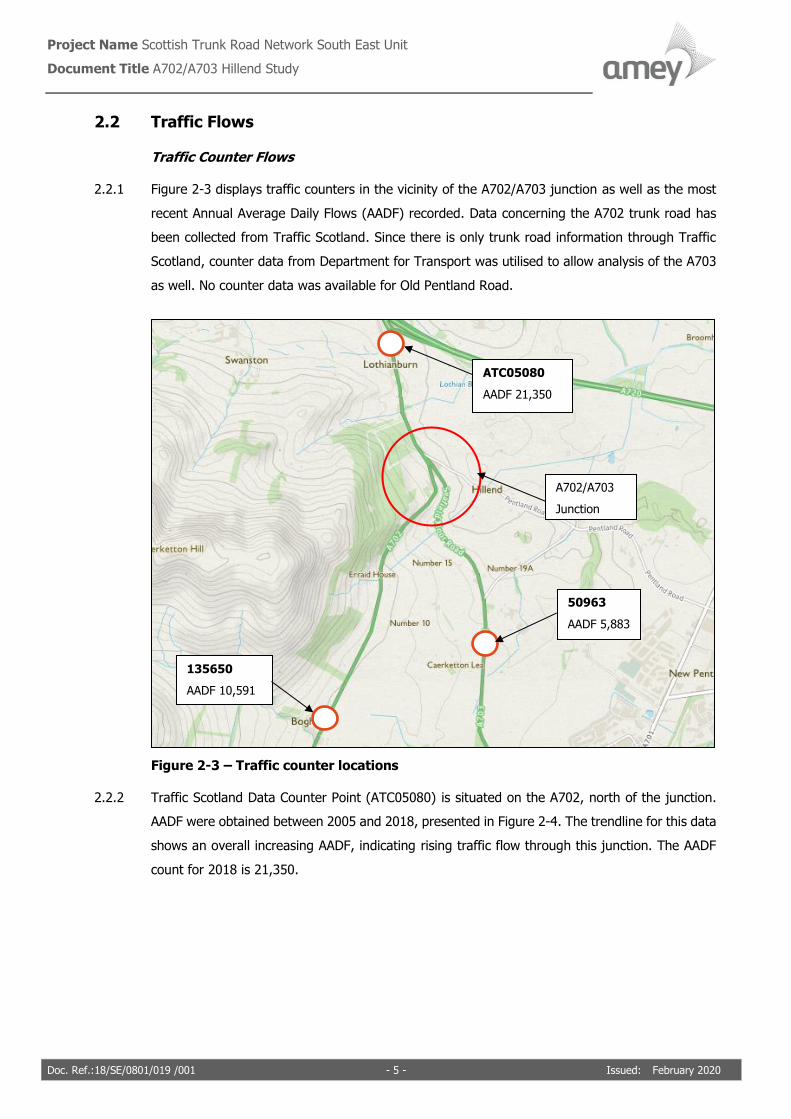
2.2.1 Figure 2-3 displays traffic counters in the vicinity of the A702/A703 junction as well as the most
recent Annual Average Daily Flows (AADF) recorded. Data concerning the A702 trunk road has
been collected from Traffic Scotland. Since there is only trunk road information through Traffic
Scotland, counter data from Department for Transport was utilised to allow analysis of the A703
as well. No counter data was available for Old Pentland Road.
Figure 2-3 – Traffic counter locations
2.2.2 Traffic Scotland Data Counter Point (ATC05080) is situated on the A702, north of the junction.
AADF were obtained between 2005 and 2018, presented in Figure 2-4. The trendline for this data
shows an overall increasing AADF, indicating rising traffic flow through this junction. The AADF
count for 2018 is 21,350.
A702/A703
Junction
ATC05080
AADF 21,350
50963
AADF 5,883
135650
AADF 10,591

Project Name Scottish Trunk Road Network South East Unit Document Title A702/A703 Hillend Study
Doc. Ref.:18/SE/0801/019 /001 - 6 - Issued: February 2020
Figure 2-4 – A702 North of Hillend AADF 2005-2018 (ATC05080)
2.2.3 Traffic Scotland Traffic Data Counter Point (135650) is situated around 800m south of the junction
on the A702, as shown in Figure 2-3. Count data for this was obtained from 2007 to 2018, as
shown in Figure 2-5. The trendline for this data also shows an increasing AADF. The current AADF
count for 2018 is 10,591.
Figure 2-5 – A702 South of Hillend AADF 2007-2018 (135650)
2.2.4 Count data from north and south of the junction indicate that approximately 10,700 vehicles enter
or exit the A702 at Hillend junction daily.
2.2.5 Department for Transport Data Counter Point (50963) is situated around 1.5km south of the
junction on the A703, also shown in Figure 2-3. AADF values were obtained from the traffic count
point for the years 2000 to 2017, presented in Figure 2-6. Unlike the A702 traffic count, this data
shows an overall decreasing AADF. The latest estimated count for this point is 5,883 AADF.
19,000
19,500
20,000
20,500
21,000
21,500
22,000
22,500
2005 2006 2007 2008 2009 2010 2011 2012 2013 2014 2015 2016 2017 2018
AAD
F
Year
9,000
9,500
10,000
10,500
11,000
11,500
12,000
12,500
2007 2008 2009 2010 2011 2012 2013 2014 2015 2016 2017 2018
AAD
F
Year

Project Name Scottish Trunk Road Network South East Unit Document Title A702/A703 Hillend Study
Doc. Ref.:18/SE/0801/019 /001 - 7 - Issued: February 2020
Figure 2-6 – A703 AADF 2000-2017 (50963)
2.2.6 Data obtained for Traffic Data Counter 50963 only had two years of results obtained using actual
counts (2006 and 2013), with the remainder predicted using estimates from the previous year’s
AADT on this link. As a result, there may be inaccuracies in this data.
2.2.7 Traffic count data for the A702 and A703 indicate that 4,800 vehicles are using the Old Pentland
Road junction daily.
2.2.8 The numbers of different vehicle classes on the A702 were obtained from the Department of
Transport Traffic Data Counter Point (Counter 80164). This data is presented in Figure 2-7. Most
vehicles passing this traffic counter are cars/taxis (79.40%), followed by Buses and LGV (13.43%)
and HGVs (5.96%).
5000
5500
6000
6500
7000
7500
8000
8500
9000
2000 2001 2002 2003 2004 2005 2006 2007 2008 2009 2010 2011 2012 2013 2014 2015 2016 2017
AAD
F
Year

Project Name Scottish Trunk Road Network South East Unit Document Title A702/A703 Hillend Study
Doc. Ref.:18/SE/0801/019 /001 - 8 - Issued: February 2020
Figure 2-7 – A702 Hillend traffic classification breakdown
2.2.9 The percentages of different vehicle classes passing the counter point on the A703 (Counter
50963) are presented in Figure 2-8. This shows a similar breakdown of vehicle classifications as
the A702 traffic count point, with cars accounting for 75.8%.
Figure 2-8 – A703 traffic classification breakdown
111 155
17542
202
2765
1317
0
2000
4000
6000
8000
10000
12000
14000
16000
18000
20000
Pedal Cycles Motorcycles Cars/Taxis Buses/Coaches Light GoodsVehicles
All HGVs
AAD
F V
olu
me
Type of Vehicle
35 58
4485
53
962
326
0
500
1000
1500
2000
2500
3000
3500
4000
4500
5000
Pedal Cycles Motorcycles Cars/Taxis Buses/Coaches Light GoodsVehicles
All HGVs
AA
DF
Vo
lum
e
Type of Vehicle

Project Name Scottish Trunk Road Network South East Unit Document Title A702/A703 Hillend Study
Doc. Ref.:18/SE/0801/019 /001 - 9 - Issued: February 2020
Conflict Study Traffic Flows
2.2.10 A conflict study was carried out as part of this report, to be discussed in detail in Section 6. As
part of this study, traffic counts were obtained over a seven-day period.
2.2.11 The number of vehicles that passed through the junction during the survey period were recorded.
Ten individual manoeuvres were recognised, shown in Figure 2-9, alongside average weekday
(Monday – Friday) traffic movement volumes recorded.
Figure 2-9 – Vehicle movement at junction
2.2.12 The most popular movement noted was vehicles travelling northbound or southbound along the
A702 (Movements 5 & 8), which equated to 56.0% of the total weekday average daily flow (ADF).
2.2.13 Traffic using the A703 junction equated to 31.4% of the weekday ADF. However, most of the
traffic flow at this junction was entering or exiting northbound (Movements 2 & 10). Cars entering
or exiting southbound, performing either a left-turn from the A703 to A702 southbound or turning
Project Name Scottish Trunk Road Network South East Unit Document Title A702/A703 Hillend Study
Doc. Ref.:18/SE/0801/019 /001 - 10 - Issued: February 2020
right from the A702 northbound to the A703 (Movements 1 & 6) only equated to 9% of the flow
related to the A703.
2.2.14 Old Pentland Road traffic was calculated to attribute to 12.6% of the weekday ADF. Again, road
users favoured travelling northbound to or from the junction (Movements 4 & 9). This equated
to 91% of traffic using Old Pentland Road.
2.2.15 Average flow of HGVs for weekdays varied between 0.3% (Movement 3) and 7% (Movement 8)
dependent on the movement carried out.
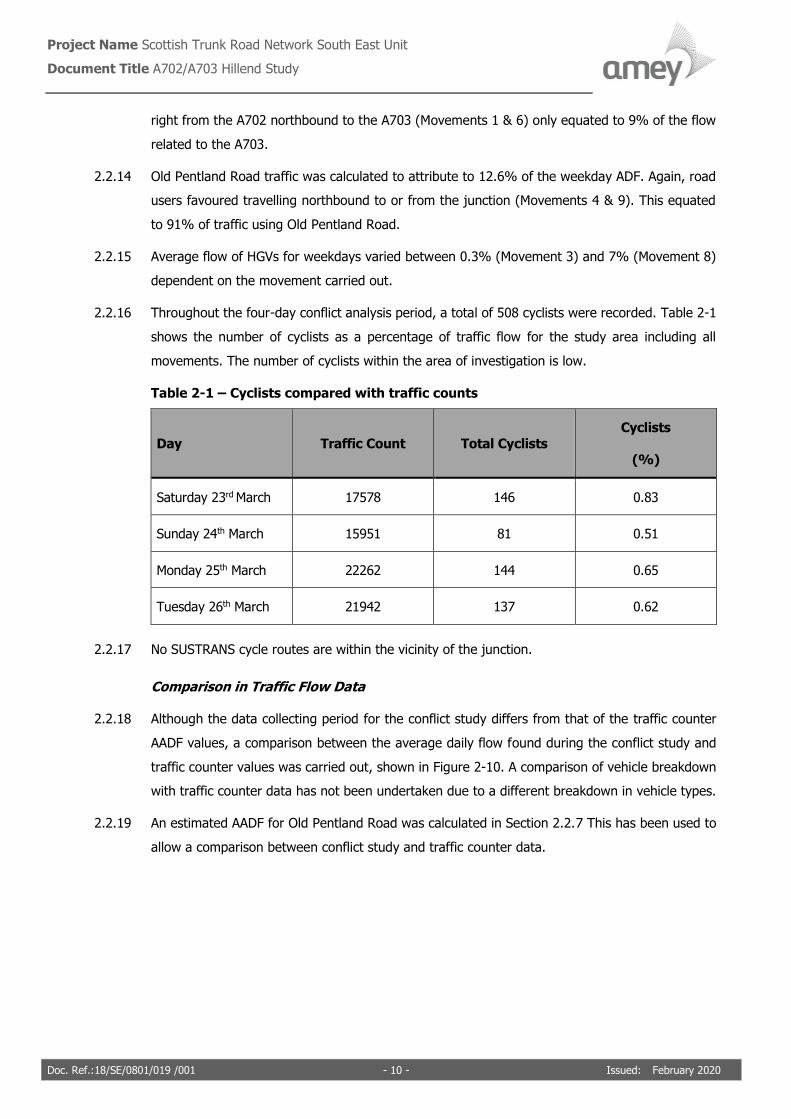
2.2.16 Throughout the four-day conflict analysis period, a total of 508 cyclists were recorded. Table 2-1
shows the number of cyclists as a percentage of traffic flow for the study area including all
movements. The number of cyclists within the area of investigation is low.
Table 2-1 – Cyclists compared with traffic counts
Day Traffic Count Total Cyclists
Cyclists
(%)
Saturday 23rd March 17578 146 0.83
Sunday 24th March 15951 81 0.51
Monday 25th March 22262 144 0.65
Tuesday 26th March 21942 137 0.62
2.2.17 No SUSTRANS cycle routes are within the vicinity of the junction.
Comparison in Traffic Flow Data
2.2.18 Although the data collecting period for the conflict study differs from that of the traffic counter
AADF values, a comparison between the average daily flow found during the conflict study and
traffic counter values was carried out, shown in Figure 2-10. A comparison of vehicle breakdown
with traffic counter data has not been undertaken due to a different breakdown in vehicle types.
2.2.19 An estimated AADF for Old Pentland Road was calculated in Section 2.2.7 This has been used to
allow a comparison between conflict study and traffic counter data.

Project Name Scottish Trunk Road Network South East Unit Document Title A702/A703 Hillend Study
Doc. Ref.:18/SE/0801/019 /001 - 11 - Issued: February 2020
Figure 2-10 – Comparison between traffic counter data and conflict study count data
2.2.20 Data categorised as ‘NB’ within Figure 2-10 compared A702 northbound traffic flows from the
conflict study and the north traffic counter, ATC05080. ‘SB’ data compares A702 southbound
traffic from the study and counter point 135650. Comparing the data, there is not a huge deviation
in conflict study and traffic counter counts. A maximum difference of 3.6% is found comparing
northbound data. However, the differences could be attributed to the fact that the traffic counters
are located further from the junction, so consider a greater area of flow.
2.2.21 Old Pentland Road was found to have the greatest deviation between results. However, since
there is no actual traffic counter on this minor road and only an estimation was used, as discussed
in Section 2.2.20, it can be assumed that unreliability in the estimation is the main factor for the
large deviation recorded.
2.2.22 Based on data from traffic counters and conflict study, the largest AADF was found north of the
junction, close to the A720, and the lowest on Old Pentland Road. This shows that both sets of
data exhibit the same pattern.
0
5000
10000
15000
20000
25000
OPR A703 NB SB
Traffic Counter
Conlfict Study Counts

Project Name Scottish Trunk Road Network South East Unit Document Title A702/A703 Hillend Study
Doc. Ref.:18/SE/0801/019 /001 - 12 - Issued: February 2020
2.3 Previous Investigations
2.3.1 Improvement works were undertaken at this junction in 2012 under the 3rd Generation (3G)
Operation & Maintenance (O&M) Contract.
2.3.2 This junction was first highlighted in the 2009-10 Moving Cursor Programme and was
subsequently investigated by BEAR Scotland.
2.3.3 As shown in Figure 2-11, the junction previously featured two lanes on the southbound
carriageway, with the near side lane acting as a slip lane for the A703. This layout made for high
speeds through the junction as drivers on the A702 had no need to reduce their speed to exit on
to the A703 or Old Pentland Road, making it difficult for drivers exiting the minor roads to find a
suitable gap for joining the main line.
Figure 2-11 – A702/A703 Hillend Junction layout pre-2012 improvements
2.3.4 The results of this investigation were that the southbound carriageway of the A702 be reduced
to one lane to increase the traffic calming effects of drivers slowing as they approach the junction.
Additionally, it was recommended that much of the signage clutter was removed and road verge
vegetation trimmed back. These improvements were implemented in 2012.
Old Pentland Road
A703
A702

Project Name Scottish Trunk Road Network South East Unit Document Title A702/A703 Hillend Study
Doc. Ref.:18/SE/0801/019 /001 - 13 - Issued: February 2020
3 Collision Analysis
3.1 Ten-Year Collision Overview
3.1.1 A review of the recorded collisions from January 2009 to December 2018 has been carried out to
identify any significant changes in collision data at the investigation site, shown in Figure 3-1.
Collision data analysis is focused on the A702 trunk road traffic due to the data available. There
was a total of 18 casualty collisions (one serious and seventeen slight) over the ten-year period,
equalling an average of 1.8 collisions per year.
Figure 3-1 – Ten-year collision profile
3.1.2 Collision data shows a decrease in fatal and serious accidents. Only one serious collision was
recorded in 2013.
3.2 Previous Improvement Works Influence on Collisions
3.2.1 Remedial measures were implemented at this junction in 2012, as discussed in Section 2.3. Since
remedial measures, collisions recorded has fluctuated. Overall, there is a decreasing trend
apparent.
3.2.2 In the five years leading up to the improvement works (2007-2011), there was a total of eleven
collisions at this junction. Ten of which were slight in severity, with one serious collision recorded
in 2007.
0
1
2
3
4
5
6
2009 2010 2011 2012 2013 2014 2015 2016 2017 2018
Num
ber
of
colli
sions
Year
Fatal
Serious
Slight
Average number
of collisions = 1.8
collisions/year

Project Name Scottish Trunk Road Network South East Unit Document Title A702/A703 Hillend Study
Doc. Ref.:18/SE/0801/019 /001 - 14 - Issued: February 2020
3.2.3 In the five years following the (2013-2017), there was a total of five collisions related to the
junctions – four slight and one serious.
3.2.4 Per year, the number of collisions on average has decreased since improvement works were
implemented. However, the frequency and nature of collisions that have occurred since still
indicate that there is an issue at the junction. Although full eradication is not possible, as set out
in the Safe Systems Approach discussed in Section 1, measures should be implemented that
prevent serious and fatal injuries. Historic collision data shows that even after improvement works
in 2012, a serious collision has occurred and therefore further remedial measures should be
considered.
3.3 Ten-Year Poisson’s Distribution
3.3.1 Considering Poisson’s Distribution, only 2010 was recorded to have results with a high confidence
over the average. All other years did not have a significant increase above or decrease below
average results. Results are shown in Figure 3-2.
Figure 3-2 – A702 A703 Hillend poisson analysis of 10 years collision data
3.4 Five-Year Collision Analysis
3.4.1 Collision data recorded between January 2014 and December 2018 has been found using
Transport Scotland’s Integrated Road Information System (IRIS) database and analysed for the
study section. Again, only data relating to the A702 trunk road has been analysed. Within this
five-year period, seven collisions were recorded, four of which relate to the junction. Collision
locations are shown in Figure 3-3, with summarised collision details in Table 3-1.
3.4.2 Detailed stick diagrams for each collision are located in Appendix A.
1% V high Confidence
5% High Confidence
10% Fair Confidence
20% Indicative (not stat significant)
No of years 10 1.9 Ave accidents per year
Year No Year Accident Total Significance
1 2008 2 56.6% Not Significant of increase over the average
2 2009 2 56.6% Not Significant of increase over the average
3 2010 5 4.4% High Confidence of increase over the average
4 2011 1 15.0% Indicative (not stat significant) of decrease below the average
5 2012 1 15.0% Indicative (not stat significant) of decrease below the average
6 2013 2 56.6% Not Significant of increase over the average
7 2014 0 15.0% Indicative (not stat significant) of decrease below the average
8 2015 3 29.6% Not Significant of increase over the average
9 2016 1 15.0% Indicative (not stat significant) of decrease below the average
10 2017 2 56.6% Not Significant of increase over the average

Project Name Scottish Trunk Road Network South East Unit Document Title A702/A703 Hillend Study
Doc. Ref.:18/SE/0801/019 /001 - 15 - Issued: February 2020
Figure 3-3 – Collision locations (Jan 2014 to Dec 2018)
Table 3-1 – Collision summary
Ref. Year Severity Light Surface Weather Direction Manoeuvres Contributory
factors
0000831 2015 Slight Dark
& Lit
Wet Rain 1 Car SN
2 HGV
<3.5 NS
1 Going
ahead other
2 Going
ahead other
1 Careless/
reckless/ in a
hurry
0000813 2015 Slight Dark
& Lit
Snow Snow 1 Car SE
NE
2 Car NW
SE
1 Turning
right
2 Going
ahead
another
1 Junction
overshoot
1 Distraction
in vehicle
0004312 2015 Slight Light Dry Fine 1 Car SN
2
Pedalcycle
SN
1 Going
ahead other
2 Going
ahead other
1 Passing too
close to
cyclist, horse
rider or
pedestrian
0001668 2016 Slight Light Dry Fine 1 HGV
<3.5 SE
NE
2 Car NS
1 Turning
right
2 Going
ahead other
1 Failed to
look properly
0004312
0000813
0001095
0001668
0000831
0000287
0000180

Project Name Scottish Trunk Road Network South East Unit Document Title A702/A703 Hillend Study
Doc. Ref.:18/SE/0801/019 /001 - 16 - Issued: February 2020
Ref. Year Severity Light Surface Weather Direction Manoeuvres Contributory
factors
0000180 2017 Slight Light Wet Fine 1 Car SE
NE
2 Car NE
SW
1 Turning
right
2 Going
ahead other
1 Failed to
look properly
0000287 2017 Slight Light Dry Fine 1 Car NS
2 Car SN
1 Going
ahead right-
hand bend
2 Going
ahead other
1 Careless/
reckless/ in a
hurry
1 Poor turn or
manoeuvre
0001095 2018 Slight Light Dry Fine 1 Car EN
2 HGV
<3.5 NS
1 Waiting to
turn right
2 Going
ahead other
1 Failed to
judge other
persons path
or speed
3.4.3 Of the four collisions recorded linked to the junction, three were travelling northbound on the
A702 and turning right. The specific minor road cannot be specified from collision data available.
Two of these collisions, both of a slight severity, cite failure to look properly as a contributory
factor, and the remaining collision overshot the junction. This highlights that visibility issues,
junction complexity and layout could have attributed to these collisions occurring. All collisions
appear to involve oncoming traffic, and no rear end shunts are recorded.
3.4.4 The final collision related to the junction was a car turning right from the A703 on to the A702,
colliding with an HGV. Failure to judge other person’s path or speed was a contributory factor for
this collision. Further investigation into the layout and driver behaviour at the junctions is studied
in Sections 4 and 5.
3.5 Annual Accident Rate (AAR) Comparison
3.5.1 The Annual Accident Rate (AAR) has been calculated for the junction between January 2013 and
December 2017. As part of the conflict study, the AADF for the junction was calculated to be
20,860. Methods used to determine this value to be further discussed in Section 6.
3.5.2 The AAR is the number of collisions per million vehicle kilometres (108 vkms) occurring on a route.
It is calculated using the following formula:
𝐴𝐴𝑅 = 𝑁𝑜 𝑜𝑓 𝑐𝑜𝑙𝑙𝑖𝑠𝑖𝑜𝑛𝑠 × 108
𝐷𝑎𝑦𝑠 𝑖𝑛 𝑃𝑒𝑟𝑖𝑜𝑑 × 𝑇𝑟𝑎𝑓𝑓𝑖𝑐 𝐹𝑙𝑜𝑤 × 𝑟𝑜𝑢𝑡𝑒 𝑙𝑒𝑛𝑔𝑡ℎ
𝐴𝐴𝑅 = 7 × 10⁸
1825 × 20,860 × 0.5
𝐴𝐴𝑅 = 36.8 𝑎𝑐𝑐/108𝑣𝑒ℎ𝑘𝑚

Project Name Scottish Trunk Road Network South East Unit Document Title A702/A703 Hillend Study
Doc. Ref.:18/SE/0801/019 /001 - 17 - Issued: February 2020
3.5.3 This value can be compared with the values for similar roads both nationally (A class) and in the
Scottish Borders and Lothian areas obtained from Tables 5(b) and 5(c) in the Reported Road
Casualties Scotland 2017. Values obtained are compared and summarised in Table 3-2.
Table 3-2 – Annual Accident Rate (AAR) comparison
A702/A703 Junction
AAR(108 vkms)
Similar Scottish
‘A’ class AAR
(108 vkms)
Deviation from
Scottish ‘A’ class
average
Similar Scottish
Borders and
Lothian AAR (108
vkms)
Deviation from
Scottish Borders
and Lothian
average
36.8 9.73 279% 10.9 239%
3.5.4 This comparison demonstrates that the accident rate at the junction under investigation is much
greater than that of comparable roads nationally and in the Lothians and Scottish Borders.
3.5.5 The high AAR value reflects that the number of collisions that have occurred in the five-year time
frame is great when compared to the AADF and length of section under investigation. Therefore,
this further demonstrates alongside collisions specifically related to the junction that the
frequency of collisions in the vicinity of the junction is high and improvements to the junction
should be investigated.

Project Name Scottish Trunk Road Network South East Unit Document Title A702/A703 Hillend Study
Doc. Ref.:18/SE/0801/019 /001 - 18 - Issued: February 2020
4 Site Investigation
4.1 Junction Layout
4.1.1 The current layout of both junctions is shown in Figure 4-1 and can be described as a non-
standard layout.
Figure 4-1 – Junction layout taken from Old Pentland Road footpath facing south
4.1.2 Guidance from CD 123 Geometric design of at-grade priority and signal-controlled junctions was
used to assess the suitability of the current junction layout between the A702 and minor roads
under current traffic demand.
4.1.3 Traffic flow data from the conflict study, as discussed in Section 2.2, has been used to estimate
the appropriate layout to accommodate the current traffic demand at the junction. Flows from
the A703 and Old Pentland Road have been accumulated to give an overall value for minor roads.
4.1.4 The existing T-junction layout would have to meet a maximum 2-way AADT of 300 for the minor
road and 13,000 for the major to comply with standards. However, based on traffic flow data
obtained, although major road 2-way AADF would allow for a simple T-junction, the minor road
flows would not. Figure 4-2 shows that a more appropriate layout to accommodate the current
traffic demand at the junction would be ‘Other junction type’. This highlights that the current
layout is insufficient when compared to the traffic flows recorded and capacity required to
accommodate the flows, and consideration into changing the current layout should be given.
Old Pentland Road
A703
A702

Project Name Scottish Trunk Road Network South East Unit Document Title A702/A703 Hillend Study
Doc. Ref.:18/SE/0801/019 /001 - 19 - Issued: February 2020
Figure 4-2 – Level of provision for junctions on single carriageway roads from DMRB
CD 123
4.2 Visibility
4.2.1 Junction visibility requirements are contained in DMRB CD 109 and CD 123 (Figure 4-3). The
design speed for the A702 at Hillend is calculated to be 85A kph. The full design speed calculation
is found in Appendix B. From Figure 4-3, the desirable minimum stopping sight distance for a
road with design speed 85 kph is 160m and the minimum visibility from a minor road entering a
major road of design speed 85 kph is 160m.
A702/A703
Hillend Junction

Project Name Scottish Trunk Road Network South East Unit Document Title A702/A703 Hillend Study
Doc. Ref.:18/SE/0801/019 /001 - 20 - Issued: February 2020
Figure 4-3 – Design geometric parameters
4.2.2 Due to the constant volume of traffic entering and exiting both junctions, measuring visibility
from the junctions in line with CD 123 in a safe manner was not possible. However, it was found
during a drive through of the site that visibility is poor from both junctions on to the A702.
4.2.3 Since measurements on site could not be done, a desktop analysis has been undertaken to better
understand constraints causing visibility issues experienced at the junction. It was found that the
road geometry of the A702 will prohibit the full 160m stopping distance being met due to
curvature in the road. On approach to the junction, the A703 runs almost parallel to the A702.
As a result, drivers entering the mainline from the A703 must look over their left shoulder in order
to check for northbound traffic. Assuming cars are approaching the junction at a perpendicular
angle, the estimated distance they can see southbound is approximately 90m before the bend
prevents further visibility.
4.2.4 However, it was found during the site visit that cars were angling to help merge better with the
traffic flow. Alignment varied depending on the direction the vehicle wished to turn on to the
A702. However, in each instance, the projected visibility of northbound traffic was reduced
further. Angles varied but an estimate of between 60m and 80m is predicted for both left and
right turns.
4.2.5 Old Pentland Road junction contains a stop sign traffic control. This highlights that visibility from
the junction is restricted such that it is mandatory for road users to stop before entering the
major road. It is estimated through desktop analysis of the junction that if a road user is
positioned perpendicular to junction markings, the maximum visibility of northbound traffic is
approximately 100m, which is also below the standard requirement of 160m.
4.2.6 This indicates that for both junctions, visibility of mainline traffic is restricted by the horizontal
alignment of the road. In both southbound and northbound directions, there are bends in the

Project Name Scottish Trunk Road Network South East Unit Document Title A702/A703 Hillend Study
Doc. Ref.:18/SE/0801/019 /001 - 21 - Issued: February 2020
road with radii 226m and 141m respectively. This results in minimum visibility from the minor
road and minimum stopping sight distances not being met.
4.3 Road Surface Condition Review
4.3.1 The surface conditions of trunk roads are regularly surveyed on behalf of Transport Scotland for
input in to the IRIS database.
4.3.2 Although Amey is not accountable for the road markings of the minor roads, investigation into
both junctions approximately 50m back from where they join with the A702 was carried out.
4.3.3 During a site visit, it was found that the High Friction Surfacing (HFS) has become very worn
around the bell mouth of the A703 junction, as shown in Figure 4-4. Give way lines at both
junctions were extremely worn. Although no collisions recorded in the last five years have been
linked to poor road markings or road conditions, the faded road markings could cause hesitation
and confusion in road users, especially those unfamiliar with the junction. Therefore, a
recommendation is made to refresh the markings although they are the responsibility of the
Midlothian Council.
Figure 4-4 – Worn high friction surface on the A703
Sideways Force Coefficient Routine Investigation Machine (SCRIM)
4.3.4 On behalf of Transport Scotland, the condition of the road surface is constantly surveyed, with
data collected uploaded into the IRIS database. This has been used to help analyse the current
condition of the A702 trunk road to determine if there are any areas that require remedial
measures.

Project Name Scottish Trunk Road Network South East Unit Document Title A702/A703 Hillend Study
Doc. Ref.:18/SE/0801/019 /001 - 22 - Issued: February 2020
4.3.5 The sideways coefficient of friction (SCRIM) of surfaces is used to show the level of grip the road
provides in wet conditions. The grip levels are measured in accordance with CD 236, Surface
course materials for construction revision 3. Actual SCRIM levels are found and compared to an
investigatory level.
4.3.6 The SCRIM survey undertaken in 2018 shows that the wet skid resistance of the road at the
entrance to both junctions is above IL, shown in green and yellow in Figure 4-5. This highlights
that at this location, there is no SCRIM deficiency. Sections highlighted in red to the north and
south of the junction represent areas with values below the IL. However, as shown in Section 3,
there were no collisions related to the road surface condition. Additionally, SCRIM levels are
checked annually as part of an independent review, CS 228, Skidding Resistance. No sites within
the investigatory location were highlighted in the 2018 recommendations. Both of these factors
show that although the SCRIM is below IL, it is not currently attributing to collisions at this
junction.
Figure 4-5 – A702 Hillend SCRIM summary
Rutting
4.3.7 Rutting is a measure of deformation of the carriageway due to traffic loading. Aquaplaning can
be caused as water can collect in the ruts. Rutting depth is regularly monitored to determine the
level of deformation on the carriageway due to traffic loading. Figure 4-6 shows the results of the
2018 rutting survey at the junction, where no evidence of any serious rutting is noticeable. As
previously stated, since there are no collisions attributed to the road surface condition, this
validates that the rutting at the junction is not a contributing factor.

Project Name Scottish Trunk Road Network South East Unit Document Title A702/A703 Hillend Study
Doc. Ref.:18/SE/0801/019 /001 - 23 - Issued: February 2020
Figure 4-6 – A702 Hillend rutting summary
Texture Depth
4.3.8 Texture is also used as an indication of surface quality. It is a measure of the macro texture,
which gives insight into the road’s ability to shed water. Low texture levels could result in a film
of water forming on the surface, which reduces the skid resistance and can cause a potential
increase in the risk of aquaplaning.
4.3.9 Texture depth results are shown in Figure 4-7. The texture depths at the junction under
investigation are all above the IL and therefore do not require further attention.
Figure 4-7 – A702 Hillend texture depth summary
4.4 Road Signs and Markings
4.4.1 As part of this investigation, signage and road markings within the study area have been
reviewed. As previous, 50m of both junctions from the junction with the A702 have been assessed
since the minor roads are not part of the South East Trunk Road Network within Amey’s
responsibility. Signs and markings were investigated during a site visit in August 2018 and results
are shown in Table 4-1.
4.4.2 A Vehicle Activated Sign (VAS) is present to the north of the junction. The purpose of this VAS is
to warn southbound vehicles travelling above a speed threshold of the approaching junction and
to slow down. The VAS was monitored during a site visit in August 2018, during this time the sign

Project Name Scottish Trunk Road Network South East Unit Document Title A702/A703 Hillend Study
Doc. Ref.:18/SE/0801/019 /001 - 24 - Issued: February 2020
was not activated once. It is unclear if speeds during the site visit were reaching threshold values
for the VAS sign to be activated. It is known that this VAS will be part of a rolling update
programme and should be upgraded shortly. Relevant maintenance teams have been notified of
the potential that the sign is not working correctly.
4.4.3 40-mph speed limit signs are placed at the junction between the A702 and A703. Since there is
no change in speed limit between the roads and gateway signs are not required, it is assumed
that these signs are in place as repeater signs. Traffic Signs Manual Chapter 3 dictates that after
a 40-mph terminal sign, there should be a repeater sign 250m from the gateway and then a
maximum of every 500m thereafter. The signs in place are too large compared to the
recommended repeater sign diameter and are not 250m away from the gateway signs. However,
signs are not misinforming road users of the speed limit. Therefore, it is recommended to do
nothing and leave the signs in place.
4.4.4 The give way and stop lines and markings at the A703 and Old Pentland Road junctions have
become very worn. It is recommended to refresh junction markings using MMA in order to make
road markings more durable, which would be the responsibility of Midlothian Council.
4.4.5 The bollard between the A703 and Old Pentland Road junction has been damaged and has lost
its reflective surface and should be replaced. This has been passed on to routine maintenance.
Table 4-1 – A702 A703 Hillend junction signs and markings
VAS situated 100m north of the junction.
Visibility partially obstructed by
vegetation. Sign part of an upgrade
programme to be replaced.

Project Name Scottish Trunk Road Network South East Unit Document Title A702/A703 Hillend Study
Doc. Ref.:18/SE/0801/019 /001 - 25 - Issued: February 2020
4.4.6
Advance directional sign obstructed by
foliage on southbound approach to
junction.
4.4.7
Damaged bollard between the A703 and
Old Pentland Road junctions – passed on
to routing maintenance.
4.4.8
40-mph sign too large to be a repeater
sign and not a gateway sign (part of
Midlothian Council’s network).

Project Name Scottish Trunk Road Network South East Unit Document Title A702/A703 Hillend Study
Doc. Ref.:18/SE/0801/019 /001 - 26 - Issued: February 2020
4.4.9
Give way line at A703 (Midlothian Council
network) junction very worn.
4.5 Bend Assessment
4.5.1 All signage and markings around the junction under investigation have been reviewed in
accordance with Advice & Procedure Guide (APG) E115. This document recommends the signs
and markings required for a bend based on its design speed of 85-kph and individual radius.
4.5.2 Figure 4-8 shows bend locations. In total, there are four bends to be considered.
Figure 4-8 – Bend categories from APG E115
4.5.3 The bend assessment highlighted three bends that require further measures to ensure compliance
with APG_E115, as shown in Table 4-2.
Bend 2
Bend 3
Bend 4
Bend 1

Project Name Scottish Trunk Road Network South East Unit Document Title A702/A703 Hillend Study
Doc. Ref.:18/SE/0801/019 /001 - 27 - Issued: February 2020
Table 4-2 – APG_E115 Bend assessment results
Bend Bend
Category
Compliance
(Y/N)
Existing signage/ road
markings
Signage/road markings
required
1 D N 100mm wide edge and
centre lines
Hazard posts, bend warning
signs and chevrons
2 D N 100mm wide edge and
centre lines
Hazard posts, bend warning
signs and chevrons
3 B N 100mm wide edge and
centre lines and bend
warning signs
Hazard posts
4 E N 100mm wide edge and
centre lines, bend warning
signs hazard posts and
chevron warning signs
SLOW road markings
4.5.4 Due to the narrow width available and existing footpaths at Bends 1 to 3, it is not feasible to
install verge marker posts or chevrons. However, for Bends 1 and 2, the installation of bend
warning signs will greatly warn road users of the horizontal alignment. For Bend 2, it is also
possible to install reflectors along the existing vehicle restraint system (VRS) at this bend, and
further investigation into the viability and benefits of installation should be investigated.
4.5.5 Bend 4 requires ‘SLOW’ road markings to be installed adjacent to existing bend warning signs.
4.6 Drainage
4.6.1 Drainage at this junction is provided by top entry gullies situated at various positions around the
junction. All gullies appear to be in good condition. Figure 4-9 displays a gully located on the
A702.

Project Name Scottish Trunk Road Network South East Unit Document Title A702/A703 Hillend Study
Doc. Ref.:18/SE/0801/019 /001 - 28 - Issued: February 2020
Figure 4-9 – Top entry gully, A702 Hillend
4.6.2 The locations of the gullies at the junction and its approaches are detailed in Figure 4-10. In
terms of routine maintenance there are no planned drainage schemes, or any drainage issues
raised at this junction. Two of the seven collisions recorded occurred when the road surface was
wet. Therefore, there is no significant trend in wet surfaces and collisions, which indicates no
drainage issues at the junction.
4.6.3 A site visit was undertaken shortly after rain had occurred. There was no standing water present
during this time, which further indicates there is no immediate drainage problem.
Figure 4-10 – A702/A703 Hillend top entry gully locations

Project Name Scottish Trunk Road Network South East Unit Document Title A702/A703 Hillend Study
Doc. Ref.:18/SE/0801/019 /001 - 29 - Issued: February 2020
4.7 Non-Motorised Users Provision
4.7.1 There is limited provision for non-motorised users at this junction. North of the junction, there is
a footpath on both sides of the A702 connecting Hillend to the City of Edinburgh. A continuous
pedestrian footpath is provided on the northbound carriageway side of the A702 south of the
junction. Two uncontrolled pedestrian crossings are located within the vicinity of the junction
under investigation. One crossing is located on the A703, and a provision of dropped kerb and
tactile paving is located at the junction of Old Pentland Road. The A702 footway and crossing
provision is shown in Figure 4-11.
Figure 4-11 – A702 Footway provision at A702/A703 Junction
4.7.2 During the conflict study, pedestrian counts were undertaken, focusing on the number of
pedestrians that cross the junction or use either the east or west footway for Old Pentland Road
or the A703. Results from the study are shown in Table 4-3.
Figure 4-12(a)
Figure 4-12(b)
Dropped kerb and
tactile paving
Uncontrolled
pedestrian crossing

Project Name Scottish Trunk Road Network South East Unit Document Title A702/A703 Hillend Study
Doc. Ref.:18/SE/0801/019 /001 - 30 - Issued: February 2020
Table 4-3 – Pedestrian crossing count results
Road Old Pentland Road
(Number of people)
A703
(Number of people)
Crossing 8 4
East kerbside 46 4
West Kerbside 11 12
4.7.3 More people were recorded using the footway and crossing facilities at Old Pentland Road than
the A703. Pedestrian usage overall was low, with the maximum of 46 people recorded using the
east kerbside of Old Pentland Road compared to four at the A703. Double the number of
pedestrians crossed Old Pentland Road than the A703. When comparing results for the west
kerbside for both minor roads, similar numbers of pedestrians were recorded.
4.7.4 This footpath varies in width (1-1.5m) and is often overgrown by vegetation, as shown in Figure
4-12. Location of where photographs have been taken are shown in Figure 4-11. On the A703
and Old Pentland Road a continuous pedestrian footway is provided on the southbound
carriageway side.
Figure 4-12 – (a) Footpath overgrown with vegetation (b) Narrow footpath
4.7.5 There is an uncontrolled pedestrian crossing on the A703 with tactile paving and dropped kerbs.
However, vegetation has grown around the kerb and tactile paving shown in Figure 4-13, which
should be removed to ensure maximum effectiveness of the crossing. Since the crossing is on the
A703, it is the responsibility of Midlothian Council to maintain it.
(a) (b)

Project Name Scottish Trunk Road Network South East Unit Document Title A702/A703 Hillend Study
Doc. Ref.:18/SE/0801/019 /001 - 31 - Issued: February 2020
Figure 4-13 – Vegetation at pedestrian crossing
4.7.6 A drop kerb with tactile paving is present on Old Pentland Road that indicates a pedestrian
crossing, shown in Figure 4-14. However, this crossing points towards the centre of the junction
where there is no area of footpath to cross to. Although this is part of Old Pentland Road and
therefore part of the local authority road, a recommendation is made to remove the drop kerb
and tactile paving in order to improve the safety of vulnerable users at this junction.
Figure 4-14 – Old Pentland Road tactile paving and drop kerb

Project Name Scottish Trunk Road Network South East Unit Document Title A702/A703 Hillend Study
Doc. Ref.:18/SE/0801/019 /001 - 32 - Issued: February 2020
4.7.7 Two bus stops are situated 50m south of the junction on the A703 on either side of the
carriageway to accommodate buses travelling in both directions, shown in Figure 4-15. These bus
stops are served every 30 minutes by Lothian Buses services 15 and X15.
Figure 4-15 – A702/A703 Hillend bus stop locations
4.7.8 One collision involving a non-motorised user has been recorded in the last ten years. This collision
involved a cyclist and a car, where the car passed too close to the cyclist.
4.7.9 Additionally, the Midlothian Council Capital View walking route begins 300m north of the junction
at the Midlothian Snowsports Centre junction. The route continues around the existing ski slope
and across the northern slopes of the Pentlands. The proximity of this walking route may attract
additional non-motorised users to this area. The walking route and starting point are shown in
Figure 4-16.
Bus stops

Project Name Scottish Trunk Road Network South East Unit Document Title A702/A703 Hillend Study
Doc. Ref.:18/SE/0801/019 /001 - 33 - Issued: February 2020
Figure 4-16 – Capital view walking route (Walkhighlands)
4.7.10 In order to improve facilities for non-motorised users at this junction, vegetation should be
trimmed back from footpaths and any incorrect tactile paving should be removed to improve
safety at this junction.
4.8 Street Lighting
4.8.1 Lighting columns are in place at all arms of the junction. On the A703 and Old Pentland Road,
columns are provided from the 40-mph gateway towards the junction. On the A702, lighting
columns are provided from the 40-mph gateway to the City of Edinburgh. Street lighting provision
at this junction is shown in Figure 4-17, with an example of street lighting on site shown in Figure
4-18.

Project Name Scottish Trunk Road Network South East Unit Document Title A702/A703 Hillend Study
Doc. Ref.:18/SE/0801/019 /001 - 34 - Issued: February 2020
Figure 4-17 – Street Lighting Provision at A702/A703 Hillend Junction
Figure 4-18 – Lighting Columns, A702/A703 Junction

Project Name Scottish Trunk Road Network South East Unit Document Title A702/A703 Hillend Study
Doc. Ref.:18/SE/0801/019 /001 - 35 - Issued: February 2020
4.9 Swept Path Analysis
4.9.1 Swept path analysis has been used to calculate the predicted path of vehicles undertaking various
movements at this junction. It was found that all manoeuvres except turning left from either
minor junction on to the A702 were acceptable. Therefore, results shown are focused on road
users turning left from minor roads.
4.9.2 Figure 4-19 shows the swept path analysis of a private car making a left turn from the A703 to
the A702. The blue line represents the swept path of the vehicle body and the red line represents
the path of the vehicle wheels. This shows that private cars must use the whole of the opposing
carriageway in order to successfully make this turn, increasing the chance of collision for vehicles
making this manoeuvre.
Figure 4-19 – Swept path analysis for private car turning left from A703 junction
4.9.3 Since the private car was not able to successfully perform the manoeuvre without using the
opposing carriageway, this indicates that vehicles larger than a private car (e.g. Large Goods
Vehicles [LGVs] and HGVs) are also unable to perform this turn within the boundaries of the lane.
This is due to the small radius turn required to turn left. Therefore, analysis was not repeated for
other larger vehicle types.
Swept path of vehicle body
Swept path of vehicle wheels

Project Name Scottish Trunk Road Network South East Unit Document Title A702/A703 Hillend Study
Doc. Ref.:18/SE/0801/019 /001 - 36 - Issued: February 2020
4.9.4 During the conflict study, the maximum number of LGVs and HGVs that performed this
manoeuvre per day was two vehicles, which equated to an average of 1% of the traffic flow
turning left from the A703 per day. This low proportion of larger vehicles performing the
manoeuvre further demonstrates the difficulty they face.
4.9.5 Figure 4-20 shows an example of a car turning left from the A703 on to the A702 and having to
encroach the northbound carriageway to successfully perform this manoeuvre, recorded during
the conflict study.
Figure 4-20 – Road user turning left from A703: (a) beginning to turn (b) encroaching
NB carriageway (c) same as previous (d) beginning to recover lane boundary
4.9.6 Figure 4-21 shows the swept path analysis for private cars turning left from Old Pentland Road.
They can successfully turn on to the A702 without encroaching the opposing traffic lane. However,
drivers are required to use full lock steering to do so. As a result, if this manoeuvre is poorly
executed, it is likely to result in vehicles encroaching on the opposing carriageway. Vehicles larger
than a private car (e.g. LGVs and HGVs) are unable to make this manoeuvre within the boundaries
of the carriageway.
(b) (a)
(c) (d)

Project Name Scottish Trunk Road Network South East Unit Document Title A702/A703 Hillend Study
Doc. Ref.:18/SE/0801/019 /001 - 37 - Issued: February 2020
Figure 4-21 – Swept path analysis for private car turning left from Old Pentland Road
junction A703
4.9.7 Vehicles are likely to encroach the red hatching in order to make this turn more easily. This
manoeuvre was found to be common during an assessment of the conflict study. Figure 4-22
gives an example of a road user encroaching nearside hatching while turning left.
Figure 4-22 – Road user turning left from Old Pentland Road conflict study
encroaching nearside red hatching
Swept path of vehicle body
Swept path of vehicle wheels
(a) (b)
Project Name Scottish Trunk Road Network South East Unit Document Title A702/A703 Hillend Study
Doc. Ref.:18/SE/0801/019 /001 - 38 - Issued: February 2020
4.10 Future Developments
4.10.1 Several areas of development have been highlighted in the vicinity of the junction under
investigation which would influence trip generation. It is known that the capacity of the junction
is currently exceeded, and therefore any further developments will not result in over capacity of
the junction but add to the existing issue.
4.10.2 As part of the Edinburgh City Deal, it is known that there is going to be a new link road constructed
between the A701 and the A702. This is also likely to increase trip generation at the A702/A703
Hillend junction. Further information will be required on this proposal, alongside all other
developments, to establish exactly how they will impact traffic movements in the area before
finalisation of any options.

Project Name Scottish Trunk Road Network South East Unit Document Title A702/A703 Hillend Study
Doc. Ref.:18/SE/0801/019 /001 - 39 - Issued: February 2020
5 Site Observations
5.1 Overview
5.1.1 A site visit and concurrent video survey independent of the conflict study were undertaken to
assess the junction. A dash camera was used to carry out the video survey. These activities were
carried out to help understand how the junction performed in terms of driver behaviour of road
users as well as to highlight any other issues with road condition.
5.1.2 The site visit was undertaken in August 2018 and the video survey in January 2019 between
14:30 and 15:30. During the survey, all movements available at the junction were recorded except
for turning left from the A703 to the A702 southbound. The survey vehicle was unable to safely
turn left from the A703 to the A702 southbound (as noted in Section 4.9) so this movement was
not carried out.
5.2 Driver Behaviour
A703 from A702 Southbound
5.2.1 Through visual assessment, it was established that drivers turning southbound from the A702 to
the A703 can perform this manoeuvre with only a limited reduction in speed. This was executed
by driving over the red hatching areas present at the outside of the junction and between the
lanes. This manoeuvre was recorded during the site visit and video survey, as shown in Figure
5-1. The intended traffic calming effect of vehicles slowing as they approach the junction is lost.
Figure 5-1 – Vehicle turning from the A702 SB to the A703 crossing the red hatching
during: (a) site visit (b) video survey
5.2.2 As a result of vehicles crossing this hatching, road users approaching Old Pentland Road junction
are stopping short of the stop line to allow road users to cross the hatching when entering the
A703 from the A702 southbound reducing the vehicles on Old Pentland Roads visibility. This is
shown in Figure 5-2.
(a) (b)

Project Name Scottish Trunk Road Network South East Unit Document Title A702/A703 Hillend Study
Doc. Ref.:18/SE/0801/019 /001 - 40 - Issued: February 2020
Figure 5-2 – Road user stopping short of Old Pentland Road stop line
5.2.3 Drivers were observed edging forward from either minor junction in an attempt to join the A702.
This caused road users travelling southbound on the A702 to encroach on to the oncoming
carriageway to avoid a collision.
Old Pentland Road from A702 Northbound and Southbound
5.2.4 Joining Old Pentland Road from the A702 was recorded twice during the survey, once northbound
and once southbound. In both directions, the survey vehicle had to brake sharply after entering
Old Pentland Road due to narrow road width and oncoming traffic. Photographs taken during the
northbound and southbound direction are shown in Figure 5-3 and Figure 5-4 respectively.
Figure 5-3 – A702 SB to Old Pentland Road: (a) prior to turning, sharp radii produced
by hatching (b) mid turn, narrow carriageway ahead
(a) (b)

Project Name Scottish Trunk Road Network South East Unit Document Title A702/A703 Hillend Study
Doc. Ref.:18/SE/0801/019 /001 - 41 - Issued: February 2020
Figure 5-4 – A702 NB to Old Pentland Road: (a) prior to turning, large turning angle
required (b) post turn, oncoming traffic and narrow carriageway
5.2.5 In both occurrences, opposing vehicles were still in their lane. However, this was found to not
always be the case, shown in Figure 5-5. This is caused by the narrow carriageway on approach
to the junction.
Figure 5-5 – Old Pentland Road vehicle using opposing traffic lane
5.2.6 Alongside road users turning into the A703, it was apparent that drivers entering Old Pentland
Road from the A702 were driving over red hatching present as well. One reason for this is that it
allows road users to enter the junctions at faster speeds, since discounting the hatching increases
the turning radii and the width of the junction access. The hatching helps produce a more curved
(a) (b)

Project Name Scottish Trunk Road Network South East Unit Document Title A702/A703 Hillend Study
Doc. Ref.:18/SE/0801/019 /001 - 42 - Issued: February 2020
access and egress to both junctions, but since this edge line is not reinforced through kerbing, it
is easy for users to disregard. Examples of vehicles crossing the hatching while entering the A703
are shown in Figure 5-1.
A702 Northbound from A703
5.2.7 When using the junction during the site visit, it was notably onerous to turn right on to the A702
from the A703. This was due to the skewed approach making it difficult for drivers to check both
directions, as shown in Figure 5-6. Difficulty checking both traffic directions makes gap
acceptance harder which can lead to driver frustration due to long waiting times.
Figure 5-6 – Visibility difficulties at the A702/A703 junction
5.2.8 It was observed that road users approaching the junction from the A703 were using the opposing
traffic lane. This allowed road users to better align with the give way line at a right angle to
increase visibility and be able to safely check the mainline in both directions before joining the
A702. The use of the opposing lane greatly increases the probabilities of a head on collision.
However, there is no historical evidence of this collision type occurring at this junction.
A702 Southbound from Old Pentland Road
5.2.9 As discussed in Section 4.9, turning left from Old Pentland Road on to the A702 requires full lock
steering in order to complete the manoeuvre without encroaching the opposing traffic lane. When
making this manoeuvre in practice, it was found that many vehicles cross over the nearside red
hatching to better align with mainline traffic and decrease the angle required to turn on to the
A702. Figure 5-7 shows a road user crossing over hatching to turn on to the A702.

Project Name Scottish Trunk Road Network South East Unit Document Title A702/A703 Hillend Study
Doc. Ref.:18/SE/0801/019 /001 - 43 - Issued: February 2020
Figure 5-7 – Old Pentland Road to A702 SB, vehicle crossing nearside hatching: (a)
begins to turn as Amey vehicle turns into A702 (b) continues to turn
Priority Confusion
5.2.10 During the video survey, in one instance it was unclear who had priority due to the two junctions
neighbouring each other. The survey vehicle was travelling northbound on the A702, turning on
to the A703 and the other vehicle was turning from Old Pentland Road on the A702 southbound.
5.2.11 The survey vehicle and user turning from Old Pentland Road decided to move off at the same
time, shown in Figure 5-7, as it was unclear to the vehicle entering the A702 whether the survey
vehicle was intending to turn on to the A702 or Old Pentland Road due to the close proximity of
the junctions. No collision occurred, however this is a clear point of conflict.
5.2.12 It is clear from site investigations that the current layout of the junctions is causing conflict
entering and exiting from the A702 both northbound and southbound. Alignment and widths of
the junctions are causing vehicles to disregard current road markings such as centre lines and
red hatching to allow for angles and positioning more desirable to road users. Such issues are
having a consequential effect on other road users simultaneously using the junction. For example,
users are not reaching the stop line on Old Pentland Road to allow vehicles entering the A703 to
cut across red hatching. Such manoeuvres are causing serious points of conflict, and therefore
remedial measures must be implemented to alter driver behaviour at this location.
(a) (b)

Project Name Scottish Trunk Road Network South East Unit Document Title A702/A703 Hillend Study
Doc. Ref.:18/SE/0801/019 /001 - 44 - Issued: February 2020
6 Conflict Study
6.1 Background
6.1.1 The purpose of this conflict study was to identify any difficulties encountered by road users at
the A702/A703 Old Pentland Road junction. Although collision data does show a trend in right
turn collisions from the A702 on to the A703, the conflict study was undertaken to provide a more
comprehensive overview of the junction, behaviour of road users and any near-miss incidents.
6.1.2 24-hour video cameras were used to carry out the surveys during Spring 2019 over a seven-day
period to record the interaction of traffic at the junction. For all seven days, turning counts were
recorded. For four of these days, footage was assessed in terms of conflicts. Although possible
to assess conflicts for the full data set, it was deemed that assessing two weekend and two
weekdays would allow sufficient data for analysis. Camera locations can be found in Appendix C.
6.1.3 This section outlines the results and conclusions from the survey. Data has been summarised
with a full set of survey results available upon request.
6.2 Survey Methodology
6.2.1 The conflict study was carried out using The Royal Society for the Prevention of Accidents (RoSPA)
Road Safety Engineering Manual as a guideline. Conflicts within the Manual are organised in terms
of severity for situations where, if the movements of one or more road user were to stay constant,
there is a risk of a collision occurring.
6.2.2 RoSPA severities do not categorise the specific manoeuvre that caused the conflict. Instead, it
assesses the response road users have to a conflict. To better understand the manoeuvres and
decisions that were attributing to conflicts at the investigation site, data was first categorised
based on predefined conflict descriptions. A major influence on this method of data processing
was due to the unusual layout of the neighbouring junctions, which resulted in a variety
manoeuvres from which conflicts could arise. Conflict descriptions are shown in Table 6-1.
6.2.3 Once a conflict type was established, a severity could be awarded. As previously stated, severities
used are based on guidelines from RoSPA. During analysis of the conflict study data, it was found
that several road users were not using the road layout as designed. However, no other cars were
affected by these actions, so no actual conflict arose. An additional severity of zero has been
added to the severity rankings to account for such scenarios where although a conflict was not
instigated, there was great potential for one to have occurred. Severities are shown in Table 6-2.

Project Name Scottish Trunk Road Network South East Unit Document Title A702/A703 Hillend Study
Doc. Ref.:18/SE/0801/019 /001 - 45 - Issued: February 2020
Table 6-1 – Conflict descriptions
Conflict
Type Incident Description Comment
1 Crossing of centre line on A702 due to wrongly
positioned vehicles at junction exits.
-
2 Cutting hatchings & crossing into wrong lane on
A703/Old Pentland Road.
Split further into the minor
roads they occurred on.
3 Vehicles mounting pavement due to queuing traffic
when exiting A702.
-
4 Unusual Manoeuvres. U-turns in junctions, using
opposite lane, cutting across
hatching.
5 Vehicles not stopping at exit of Old Pentland Road. -
6 Crossing centre line when moving from junction to
junction/junction A702 NB.
Split further into the minor
roads the vehicle exited.
Table 6-2 – RoSPA conflict severities
Severity Description
0 Manoeuvre where only one vehicle is involved with the potential to cause conflict
(ie road users crossing into the wrong lane but no oncoming traffic, so no conflict
occurs).
1 Precautionary conflict (i.e. braking for vehicle waiting to emerge, precautionary
lane change or anticipatory braking).
2 Controlled braking or lane change to avoid collision, but with ample time for
manoeuvre.
3 Rapid deceleration, lane change or stopping to avoid collision, resulting in a near
miss. No time for steady controlled manoeuvre.
4 Emergency braking or violent swerve to avoid collision resulting in very near miss
or occurrence of a minor collision.
5 Emergency action followed by collision.

Project Name Scottish Trunk Road Network South East Unit Document Title A702/A703 Hillend Study
Doc. Ref.:18/SE/0801/019 /001 - 46 - Issued: February 2020
6.3 Peak Hours
6.3.1 During weekday surveys, the AM peak was observed between 07:15 and 08:45, with the PM peak
recorded between 16:30 and 17:30. During the weekend surveys the AM peak was observed
between 11:00 and 12:00, with one PM peak recorded between 12:30 and 13:30 and the other
between 13:30 and 14:30.
6.3.2 Over the four-day conflict survey period, a total of 96 hours of video footage was assessed and
analysed for any trends in conflicts. In total, 34,072 vehicles were recorded entering or exiting
between the A702 and either Old Pentland Road or the A703.
6.3.3 Of the 34,072 users recorded across all eight turning movements described in Section 2.2, 5,876
conflicts were recorded. Table 6-3 shows the breakdown of severities of each conflict type.
Table 6-3 – Breakdown of severity
Conflicts
Severity 1 2 3 4 5 6 Total
0 0 4501 29 453 159 78 5220
1 284 16 5 21 0 0 326
2 68 4 1 19 1 0 93
3 51 0 2 4 0 0 57
4 0 0 0 0 0 0 0
5 0 0 0 0 0 0 0
Total 403 4521 37 497 160 78
6.3.4 The most common conflict that occurred was Type 2. Vehicles were frequently cutting hatching
and using the oncoming minor road lane when entering or exiting either junction. However, it
was found that Type 2 situations were rarely awarded severity 1 or above since this conflict
primarily occurred with a single road user and when there was no oncoming traffic.
6.3.5 Where severities of 1 or above were awarded, 95% were given severity ratings of 1 or 2. This
highlights that where a conflict did involve more than one road user, only precautionary or
controlled braking was required to mitigate a collision. No conflicts were awarded a severity of 4
or 5, showing that no road users had to emergency brake or violently swerve in a near miss or
minor collision.

Project Name Scottish Trunk Road Network South East Unit Document Title A702/A703 Hillend Study
Doc. Ref.:18/SE/0801/019 /001 - 47 - Issued: February 2020
6.3.6 The percentage of conflicts compared with the traffic flow for all movements is detailed in Table
6-4. A breakdown per day is shown.
Table 6-4 – Conflicts compared with traffic count
Day Traffic Count Total Conflicts Conflicts (%)
Saturday 23rd March 17578 1404 7.99
Sunday 24th March 15951 1351 8.47
Monday 25th March 22262 1709 7.68
Tuesday 26th March 21942 1764 8.04
6.3.7 On average, 7.33% of the traffic count resulted in a conflict. However, considering that conflicts
are related to users utilising the A703 or Old Pentland Road junctions, and that an average of
56% of traffic data recorded solely related to road users using the A702, this value of conflicts
proportional to traffic counts increases to approximately 14% when discounting traffic data not
directly related to the junction.
6.4 Vehicle Speed
6.4.1 As stated in Section 2.1, the junction is subject to a 40-mph speed limit.
6.4.2 Traffic speeds have been investigated using data recorded during the survey. Figure 6-1 below
shows the location the traffic speeds were taken.
Figure 6-1 – Traffic counter locations

Project Name Scottish Trunk Road Network South East Unit Document Title A702/A703 Hillend Study
Doc. Ref.:18/SE/0801/019 /001 - 48 - Issued: February 2020
6.4.3 The mean and 85th percentile speed as well as the percentage of vehicles exceeding the speed
limit is displayed in Table 6-5 for the seven-day survey period.
Table 6-5 – Vehicle speed
6.4.4 Figure 6-2 and Figure 6-3 display the speed behaviour of road users travelling northbound and
southbound respectively. Southbound speeds have been calculated at ATC1, located north of the
junction, to examine the speed of road users travelling southbound towards the junction. This is
also mirrored in the data depicting northbound speeds at ATC2, to allow the speeds of users
travelling northbound towards the junction to be assessed.
Figure 6-2 – 85th percentile speed at ATC1 southbound
0
10
20
30
40
50
60
00:00 03:00 06:00 09:00 12:00 15:00 18:00 21:00 00:00
Speed (
mph)
Time (hrs:mins)
Weekday 85%ile
Weekend 85%ile
Speed Limit
Direction 7-day
average
Posted Speed
Limit (mph)
% >
Speed
Limit
(mph)
Mean
Speed
(mph)
85th Percentile
Speed (mph)
Southbound 9,014 40 2.9 30.0 35.7
Northbound 10,846 40 4.4 31.2 36.0
2-way 19,860 40 3.7 30.6 35.9

Project Name Scottish Trunk Road Network South East Unit Document Title A702/A703 Hillend Study
Doc. Ref.:18/SE/0801/019 /001 - 49 - Issued: February 2020
Figure 6-3 – 85th percentile speed at ATC2 northbound
6.4.5 It is evident that road users tend to exceed the speed limit during quieter hours between midnight
and 06:00 when travelling northbound. For both directions, there is a decrease in 85th percentile
speed during the day – between approximately 09:00 and 18:00 for southbound and 06:00 and
21:00 for northbound traffic. A significant trough is found in data for northbound travel at
approximately 08:00 weekdays. This trend can be attributed to the higher volume of vehicles at
this time. Maximum and minimum 85th percentile speeds calculated of users travelling southbound
was higher than those travelling northbound. More traffic travelled northbound, so higher traffic
flows will prohibit faster speeds.
6.4.6 Considering the seven collisions recorded between January 2013 and December 2018, there was
no strong correlation between period of higher speeds and collisions. One was recorded between
midnight and 06:00, three between 06:00 and 09:00 and the remainder during the day, between
09:00 and 19:00. It is possible that periods where there are more road users are causing more
collisions due to the increased driver confusion regarding junction layout.
6.4.7 Although only a small portion of conflicts were found to have a severe effect on road users by
causing emergency breaking, a very close near miss or a minor collision, the proportion of minor
severities was much greater. This highlights that although there is not a high percentage of severe
conflicts occurring at present, there is high potential for this to occur in the future based on the
amount of existing near-misses. Conflicts of any severity arising should be mitigated as much as
possible.
6.4.8 Traffic speeds show that a small proportion of traffic exceeds the speed limit, generally during
the night. Daytime speeds are restricted by the traffic flow volumes.
0
5
10
15
20
25
30
35
40
45
50
00:00 03:00 06:00 09:00 12:00 15:00 18:00 21:00 00:00
Speed (
mph)
Time (hrs:mins)
Weekday 85%ile
Weekend 85%ile
Speed Limit

Project Name Scottish Trunk Road Network South East Unit Document Title A702/A703 Hillend Study
Doc. Ref.:18/SE/0801/019 /001 - 50 - Issued: February 2020
7 Remedial Options
7.1 Overview
7.1.1 Following detailed analysis of the site under investigation, remedial measures have been identified
in terms of potential to improve the overall safety of the junction. Options have been produced
using data from a desktop study of the area. Therefore, some assumptions made will require
further investigation should they be considered further.
7.1.2 Three options have been created, ranging from short-term implementation measures to long-
term, high cost junction layout alterations. The feasibility and buildability of each option varies
considerably.
7.1.3 All options reviewed will have an impact on the existing Local Authority side roads. Therefore,
liaison with Midlothian Council is required since the minor roads are part of their network.
7.2 Remedial Measures
7.2.1 Remedial measures reviewed are shown in Table 7-1. Advantages, disadvantages and estimated
cost ranges are also shown. Reasons for the creation of each option are also outlined to establish
the necessity of the measure and what issues it can improve at the junction. Drawings for each
option can be found in Appendix D.
7.2.2 Consideration into signalising the junction using the existing layout was also assessed. A Linsig
model projecting the effect of signals was created, focusing on the AM and PM peaks. Data
collected from the traffic counts discussed in Section 2.2 was utilised. The model found that
signalisation of the existing layout would results in oversaturation of the junction. AM peak results
showed that saturation of up to 119% would be reached. Is it estimated that if 85% of junction
capacity is reached, a junction has reached its initial saturation point, highlighting how the
junction would perform above this saturation point with signals installed. Analysis showed
maximum queues of 76 passenger car units (PCU) predicted in the northbound direction, which
equates to approximately 230m in length.
7.2.3 PM peak statistics show that signalisation of the junction would cause a queue of 273 PCU
(approximately 819m in length), with a maximum saturation of 694% possible in the northbound
direction. This further corroborates that signalising the existing junction would have an extremely
negative impact on road users, with high junction saturation and long queues. From this analysis,
results were unanimous in the fact that signalising the existing junction would have detrimental
effects on queuing and would cause additional strain to the network at this location. Therefore,
this option has not been included within remedial measures below.

Project Name Scottish Trunk Road Network South East Unit Document Title A702/A703 Hillend Study
Doc. Ref.:18/SE/0801/019 /001 - 51 - Issued: February 2020
7.2.4 Cost of land has been estimated using historic scheme statistics, and it is recommended a District
Valuer is contacted to properly appraise the worth of the land. SPONS rates have been used to
estimate the predicted cost of construction for each option.
7.2.5 Based on the assumptions outlined and the extent of further investigation required for remedial
measures, as stated above, cost ranges provided are approximate and have been included to
provide some insight to initial estimations based on preliminary desktop studies. Cost rankings
are likely to remain consistent even with fluctuations in design and construction required.
However, overall final costs are likely to vary based on the need for a detailed geotechnical
investigation to finalise earthworks required, fluctuations in land value and in-depth analysis into
the optimal vertical and horizontal alignment of the proposed measures must be carried out. This
is predominantly applicable for Options 2 and 3.
7.2.6 Calculations to determine the capacity of the roundabout can be found in Appendix E.

Project Name Scottish Trunk Road Network South East Unit Document Title A702/A703 Hillend Study
Doc. Ref.:18/SE/0801/019 /001 - 52 - Issued: February 2020
Table 7-1 – Reviewed remedial measures
Option Description Reason Advantages Disadvantages Cost
1A • Prohibiting left
turns exiting
minor roads.
• Swept path analysis and conflict
study results show encroaching
the northbound carriageway is
extremely likely for cars turning
left from the A703, and
therefore inevitable for any
larger vehicles due to the angle
of the junction and width of
carriageway.
• Mitigates encroachment of
oncoming carriageway when
turning left.
• Reduces potential of head on
collisions with mainline traffic
travelling northbound.
• Additional trip generation at other
locations - particularly north of the
junction. Approximately 3-6 minutes
additional journey time estimated
from INREX.
• Road users may continue to make left
turn manoeuvre.
• Poor visibility remains, predominantly
looking left from minor routes
(specifically the A703).
• More right turn manoeuvres
encouraged.
• Level of provision does not equate to
traffic flows at the junction.
£15,000 -
£30,000
1B • One-Way
System (Junction
in – A703 /
Junction out –
Old Pentland
Road).
• Visibility of the A702 from the
A703 is poor and does not meet
standards, particularly for minor
road users looking southbound.
This is due to road alignment of
the main carriageway.
• Limits number of manoeuvres
possible, reducing potential
conflicts.
• Prevention of junction priority
confusion which occurred during
site visits.
• Additional trip generation at other
locations - particularly north of the
junction. Approximately 3-6 minutes
additional journey time estimated
from INREX.
£15,000 -
£30,000

Project Name Scottish Trunk Road Network South East Unit Document Title A702/A703 Hillend Study
Doc. Ref.:18/SE/0801/019 /001 - 53 - Issued: February 2020
• Better visibility for road users
approaching the A702 from Old
Pentland Road – increased visibility
looking southbound when
compared to available visibility
from the A703.
• Reduction in road users
encroaching the minor road
oncoming traffic lane when turning
right into the junctions from the
A702. This was observed during
the conflict study.
• Preventing traffic turning into Old
Pentland Road from the A702 will
eradicate gaps in the traffic flow
currently provided for users turning
right on to the A702. This is since road
users travelling south will now turn
into the A703 only, so no traffic is
slowing prior to turn into Old Pentland
Road. This will increase the difficulty
in turning right from the minor road
(A703) on to the mainline
carriageway.
• Level of provision does not equate to
traffic flows at the junction.
• Previously discussed and discounted
by Midlothian Council.
1C • Prohibition of
right turn from
A702 on to minor
roads.
• This manoeuvre was associated
with three of the seven
collisions recorded within a five-
year period (2014-2018),
discussed in Section 3.4.
• Reduction in potential for head on
collisions to occur.
• Limits number of manoeuvres
possible, reducing potential
conflicts.
• Reduction in road users
encroaching the minor road
• Additional trip generation at other
locations - particularly north of the
junction. Approximately 3-6 minutes
additional journey time estimated
from INREX.
• Level of provision does not equate to
traffic flows at the junction.
£15,000 -
£30,000

Project Name Scottish Trunk Road Network South East Unit Document Title A702/A703 Hillend Study
Doc. Ref.:18/SE/0801/019 /001 - 54 - Issued: February 2020
oncoming traffic lane when turning
right into the junctions from the
A702. This was observed during
the conflict study.
• Road users may continue to make
right turn manoeuvre.
• Eradication of gaps in the northbound
A702 traffic, which will result in more
difficulty for road users joining the
A702 from minor roads.
2A • Partial closure
and realignment
of the A703.
New junction to
be created, with
Old Pentland
Road traffic
joining the
realigned A703.
• Junction to be
signalised.
• Visibility from the minor
junctions is poor, particularly
looking southbound. Junction
layout is known to cause
priority confusion, and
alignment of the A703 to the
A702 is almost parallel.
• Level of provision currently
available at the junction does
not equate to traffic flows –
this would upgrade the
junction such that is would fall
under the category ‘Other
junction type’.
• Simplification of junction layout,
which is currently known to cause
road user confusion.
• Improved forward visibility looking
southbound from the new
proposed A703 junction to the
A702.
• Controlled traffic movement,
preventing drivers misjudging gap
sizes.
• Realignment of the A703 with
larger radii, increasing visibility on
the minor road and improving
sight stopping distances.
• Alignment location ensures no
proximity to existing private
buildings.
• Land acquisition required (approx.
20,000m2).
• Increased journey time for users on
the local access section of the A703.
• Earthworks and regrading of land –
geotechnical investigation required.
• Increased traffic flows to the new
junction.
• Departures required for horizontal
and vertical alignment.
• Relocation of existing carrier poles on
Old Pentland Road required.
• New access roads required for Old
Pentland Road private property.
• Potential delays and queuing – full
LINSIGG model required.
£4 – £6
million

Project Name Scottish Trunk Road Network South East Unit Document Title A702/A703 Hillend Study
Doc. Ref.:18/SE/0801/019 /001 - 55 - Issued: February 2020
• Private access A703 to be utilised
by non-motorised users.
• Inadequate sight stopping distance
for A702 northbound traffic without
additional road alterations.
• Possibility of increase in rear end
shunts.
2B • Realignment of
the A703. New
junction to be
signalised.
• Old Pentland
Road to be used
as existing. Right
turn ghost island
to be
constructed.
• Visibility from the minor
junctions is poor, particularly
looking southbound. Junction
layout is known to cause
priority confusion, and
alignment of the A703 to the
A702 is almost parallel.
• Level of provision currently
available at the junction does
not equate to traffic flows –
this would upgrade the
junction such that is would fall
under the category ‘Other
junction type’.
• Simplification of junction layout,
which is currently known to cause
road user confusion.
• Improved forward visibility looking
southbound from the new
proposed A703 junction to the
A702.
• Controlled traffic movement,
preventing drivers misjudging gap
sizes.
• Land acquisition required (approx.
10,000m2).
• Increased journey time for users on
the local access section of the A703.
• Extensive earthworks and regrading
of land – geotechnical investigation
required.
• Departures required for horizontal
and vertical alignment.
• Potential delays and queuing – full
LINSIGG model required.
• Possibility of increase in rear end
shunts.
• Relocation of A703 traffic flows may
result in limited gaps at Old Pentland
Road for users to join the A702.
£3 - £5
million

Project Name Scottish Trunk Road Network South East Unit Document Title A702/A703 Hillend Study
Doc. Ref.:18/SE/0801/019 /001 - 56 - Issued: February 2020
3A • Roundabout to
be located in the
vicinity of the
existing junction.
• Old Pentland
Road users to
join A703.
• Level of provision currently
available at the junction does
not equate to traffic flows –
this would upgrade the
junction such that it would fall
under the category ‘Other
junction type’.
• Junction capacity able to
accommodate traffic flows.
• Reduction in potential conflicts
due to new road layout, which will
also remove any priority
confusion.
• Realignment of A702 south
removes current visibility issues
on the approach to the existing
junction and removes several
bends with tight radii from the
mainline.
• Alignment location ensures no
proximity to existing private
buildings.
• Land acquisition required (approx.
35000m2).
• Encroachment of private property to
realign A702 south.
• Regrading of land due to 1:8 slope
(approximate) to accommodate
proposed layout required –
extensive geotechnical investigation
required.
• Increased traffic flows to the A703
due to closure of Old Pentland Road.
• Departures likely required due to
vertical and horizontal alignment
proposed road alterations.
• Possibility of increase in rear end
shunts.
£8 – £11
million
3B • Roundabout to
be located at
realigned A703.
• Old Pentland
Road to be used
• Level of provision currently
available at the junction does
not equate to traffic flows –
this would upgrade the
junction such that is would fall
• Junction capacity able to
accommodate traffic flows.
• Reduction in potential conflicts
due to new road layout, which will
• Land acquisition required (approx.
25000m2).
• Regrading of land due to 1:14 slope
(approximate) to accommodate
proposed layout required –
£6 – £8
million

Project Name Scottish Trunk Road Network South East Unit Document Title A702/A703 Hillend Study
Doc. Ref.:18/SE/0801/019 /001 - 57 - Issued: February 2020
as existing.
Right turn ghost
island to be
constructed.
under the category roundabout
(or other type).
also remove any priority
confusion.
• Realignment of A702 and A703
removes current visibility issues
on the approach to the existing
junction and removes several
bends with tight radii from the
mainline.
• Old Pentland Road to function as
before, no increased traffic flows
to the A703
extensive geotechnical investigation
required.
• Departures likely required due to
vertical and horizontal alignment
proposed road alterations.
• Possibility of increase in rear end
shunts.

Project Name Scottish Trunk Road Network South East Unit Document Title A702/A703 Hillend Study
Doc. Ref.:18/SE/0801/019 /001 - 58 - Issued: February 2020
8 Conclusions and Recommendations
8.1.1 An assessment of the existing junction layout has been carried out to highlight any existing issues
based on the frequency and similarity in collisions that have occurred.
8.1.2 It was found that the existing layout is not to current standards, and the available capacity cannot
cope with the current level of traffic demand from the minor roads the junction currently
undergoes. Previous remedial measures at this junction have attempted to address this problem,
including the reduction of the southbound carriageway to one lane. However, a collision problem
still exists and with the new developments proposed in the vicinity of the junction, an increase in
trip generation is to be expected.
8.1.3 Existing provisions for non-motorised users is poor in the vicinity of the junction, with footways
below current standard provided. However, the increase in approved developments will result in
an increase in trip generation of not only road users but pedestrians and cyclists as well.
Therefore, further improvements and investigations will be required to ensure the safety of non-
motorised users as well.
8.1.4 Collision analysis determined that collisions were commonly caused by human error. Turning right
into the minor junction, assumed to be the A703 based on collision data available, attributed to
three collisions associated with the junction. Although contributory factors did not cite road layout
as an issue, it is possible that a combination of the layout, traffic flow and driver decisions
impacted on the number of collisions occurring.
8.1.5 Conclusions from the conflict study further highlight the benefits that would be occur from
remedial measures at this junction. No serious conflicts occurred, however, the high level of near-
miss conflicts and the projected increase in traffic flow gives rise to a higher potential for future
collisions.
8.1.6 From investigation, seven remedial options have been reviewed, ranging from implementing
TROs, adding additional signage to alterations of the existing road layout. Minor roads are the
responsibility of Midlothian Council. Therefore, agreement between Transport Scotland and
Midlothian Council concerning future improvements and options that can be implemented to this
junction must be sought. Remedial measures reviewed, alongside estimated costs are shown in
Table 8-1.
8.1.7 Signalisation of the junction using the existing layout was also considered. However, it was
concluded through modelling this proposal in Linsig that this would cause queues up to 274 PCU
and would result in high levels of junction saturation. Due to these issues, the measure was
discounted and has not been considered further or alongside other remedial measures.

Project Name Scottish Trunk Road Network South East Unit Document Title A702/A703 Hillend Study
Doc. Ref.:18/SE/0801/019 /001 - 59 - Issued: February 2020
Table 8-1 – Remedial measures and costs
8.1.8 Advantages and disadvantages outlined in Section 7 should be considered when establishing the
optimal solution. Within the study area, only the A702 is part of the South East Trunk Road Unit,
with Midlothian Council being responsible for the A703 and Old Pentland Road. Therefore, liaison
with Midlothian Council and further investigation of potential remedial measures outlined will be
essential to ensure a collaborative solution is agreed upon.
8.1.9 The investigatory nature of this report results in the provision of approximate values for long term
options since specific volumes and quantities and detailed scope of works are not known. Land
and property costs have been estimated using available data sources for other schemes, and it is
recommended that for more detailed information, District Valuer Services are utilised. Since costs
are indicative and should only be used as an initial value, no economic justification has been
provided at present.
Option Measure Estimated Cost
1A TRO - Prohibiting left turns exiting minor roads. £15,000 - £30,000
1B TRO - One-Way System (Junction in – A703 / Junction out – Old Pentland
Road).
£15,000 - £30,000
1C TRO - Prohibition of right turn from A702 on to minor roads. £15,000 - £30,000
2A Realignment of A703. Closure of Old Pentland Road junction. New
signalised junction to be constructed in vicinity of existing junction.
£4 – £6 million
2B
Closure of existing A703 junction, realignment and signalisation of new A703
junction south of existing. Old Pentland Road to remain as existing with
addition of right turn ghost island.
£3 - £5 million
3A
Connection of Old Pentland Road to A703 and construction of roundabout
in the vicinity of existing junction. Realignment of A702 south of proposed
roundabout.
£8 – £11 million
3B
Closure of existing A703 junction, realignment and roundabout construction
using the new A703 alignment. Old Pentland Road to remain as existing
with addition of right turn ghost island.
£6 – £8 million

Project Name Scottish Trunk Road Network South East Unit Document Title A702/A703 Hillend Study
Doc. Ref.:18/SE/0801/019 /001 - A.1 - Issued: February 2020
Appendix A Collision Stick Diagrams
V2
V1
V
V2
V2
V1
V2
V1
V1
V2 V1
V2
V1
V2

Project Name Scottish Trunk Road Network South East Unit Document Title A702/A703 Hillend Study
Doc. Ref.:18/SE/0801/019 /001 - B.1 - Issued: February 2020
Appendix B Design Speed Calculations for A702

Project Name Scottish Trunk Road Network South East Unit Document Title A702/A703 Hillend Study
Doc. Ref.:18/SE/0801/019 /001 - B.2 - Issued: February 2020

Project Name Scottish Trunk Road Network South East Unit Document Title A702/A703 Hillend Study
Doc. Ref.:18/SE/0801/019 /001 - C.1 - Issued: February 2020
Appendix C Camera Locations for Conflict Study

Project Name Scottish Trunk Road Network South East Unit Document Title A702/A703 Hillend Study
Doc. Ref.:18/SE/0801/019 /001 - C.2 - Issued: February 2020

Project Name Scottish Trunk Road Network South East Unit Document Title A702/A703 Hillend Study
Doc. Ref.:18/SE/0801/019 /001 - D.1 - Issued: February 2020
Appendix D Remedial Options

Project Name Scottish Trunk Road Network South East Unit Document Title A702/A703 Hillend Study
Doc. Ref.:18/SE/0801/019 /001 - D.2 - Issued: February 2020

Project Name Scottish Trunk Road Network South East Unit Document Title A702/A703 Hillend Study
Doc. Ref.:18/SE/0801/019 /001 - D.3 - Issued: February 2020

Project Name Scottish Trunk Road Network South East Unit Document Title A702/A703 Hillend Study
Doc. Ref.:18/SE/0801/019 /001 - D.4 - Issued: February 2020

Project Name Scottish Trunk Road Network South East Unit Document Title A702/A703 Hillend Study
Doc. Ref.:18/SE/0801/019 /001 - D.5 - Issued: February 2020

Project Name Scottish Trunk Road Network South East Unit Document Title A702/A703 Hillend Study
Doc. Ref.:18/SE/0801/019 /001 - D.6 - Issued: February 2020

Project Name Scottish Trunk Road Network South East Unit Document Title A702/A703 Hillend Study
Doc. Ref.:18/SE/0801/019 /001 - D.7 - Issued: February 2020

Project Name Scottish Trunk Road Network South East Unit Document Title A702/A703 Hillend Study
Doc. Ref.:18/SE/0801/019 /001 - D.8 - Issued: February 2020

Project Name Scottish Trunk Road Network South East Unit Document Title A702/A703 Hillend Study
Doc. Ref.:18/SE/0801/019 /001 - E.1 - Issued: February 2020
Appendix E Roundabout Capacity Calculations

Project Name Scottish Trunk Road Network South East Unit Document Title A702/A703 Hillend Study
Doc. Ref.:18/SE/0801/019 /001 - E.2 - Issued: February 2020

Project Name Scottish Trunk Road Network South East Unit Document Title A702/A703 Hillend Study
Doc. Ref.:18/SE/0801/019 /001 - E.3 - Issued: February 2020