project data sheet - ncdot · u-5774 nc 54 corridor improvements page 1 project data sheet . date:...
TRANSCRIPT

U-5774 NC 54 Corridor Improvements Page 1
PROJECT DATA SHEET
Date: 5/24/17 Rev.: 1
STIP No.: U-5774 County: Orange & Durham
Federal-aid No.: TBD WBS No.: 54037.1.1
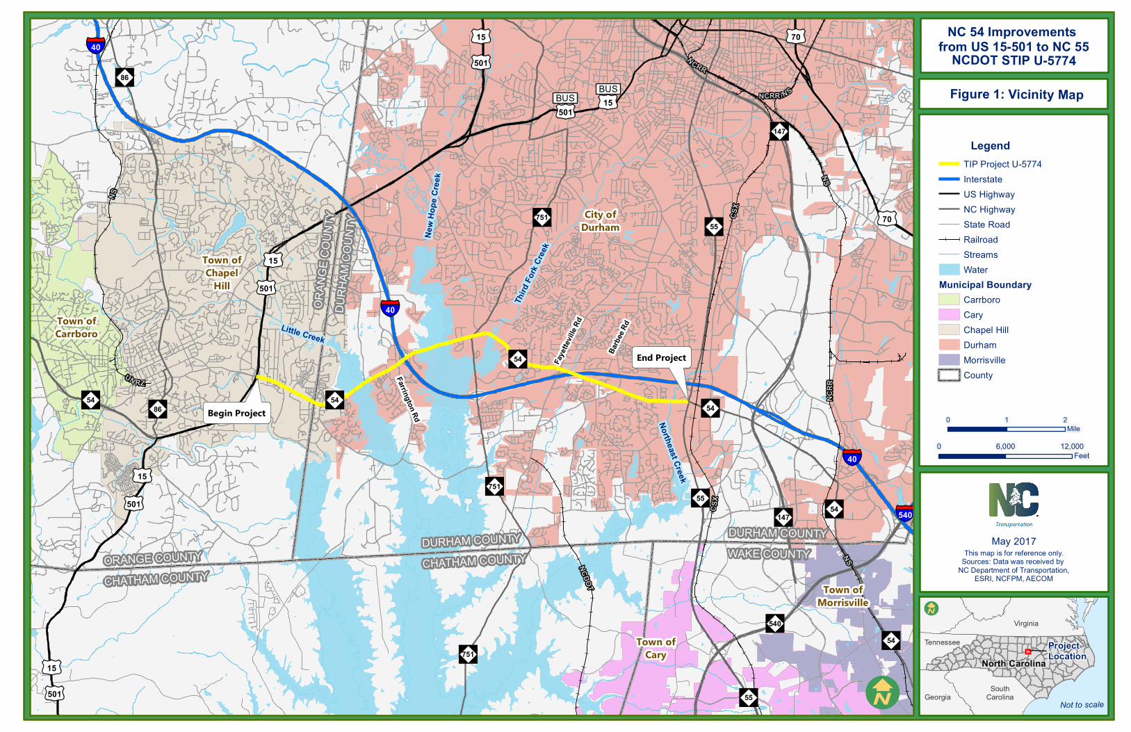
NCDOT Division: 5, 7 Scoping Meeting Date: 6/15/17 Project Description: • Length: 9.2 miles • Study Limits: US 15/501 to NC 55 • MPO / RPO: Durham-Chapel Hill-Carrboro (DCHC) Metropolitan Planning Organization • NEPA / 404 Merger Candidate? Yes No Unknown • General Description of Project: Engineering and environmental studies investigating
corridor improvements to upgrade NC 54 from US 15/501 in Chapel Hill to NC 55 in Durham. Corridor improvements within the study area may employ a variety of strategies such as roadway widening, traffic control, access management, intersection improvements, grade separations, interchange upgrades, and signal timing optimization. (See Figure 1 – Vicinity Map and Figure 2 – Study Area Map)
Design Data (Existing Conditions): • Functional Classification: NC 54 – Other Principal Arterial • Strategic Highway Corridor: No • CTP Designation (Facility Type): Boulevard (see Exhibit 1)
Exhibit 1: Draft CTP Designation – Boulevard
Source: Highway Map of the Draft Durham-Chapel Hill-Carrboro MPO Comprehensive Transportation Plan, 2016.

U-5774 NC 54 Corridor Improvements Page 2
• Type of Access Control: No control of access • Typical Section:
o 6-lane raised median w/ intermittent C&G from US 15/501 to East Barbee Chapel Road
o 4-lane median divided from East Barbee Chapel Road to east of I-40 Exit 273 o 2-lane undivided from I-40 Exit 273 to NC 55 (w/ various misc. widening)
• Right of Way: o Varies 150 ft to 310 ft from US 15/501 to I-40 Exit 273 o Varies 60 ft to 130 ft from I-40 Exit 273 to Fayetteville Road o Varies 80 ft to 130 ft from Fayetteville Road to NC 55
• Posted Speed: 35-45 mph • Structure and Greenway Inventory:
o Structures (see Exhibit 2) Structure No. 670281 (281) on US 15/501 NBL over NC 54 (bridge - RC deck on
PPC girders, PPC deck panels, approach slabs). Structure No. 670045 (045) on US 15/501 SBL over NC 54 (bridge - RC deck on
girders with latex modified concrete overlay, approach slabs). Structure No. 310320 (320) on NC 54 EBL over Little Creek (bridge – RC floor on
ppc girders). Structure No. 310319 (319) on NC 54 WBL over Little Creek (bridge – RC floor on
ppc girders). Structure No. 310314 (314) on NC 54 over I-40 Exit 273 (bridge - RC floor on
steel plate girders). Structure No. 310013 (013) on NC 54 over New Hope Creek (culvert – quadruple
8’x11’ RCBC). Structure No. 310041 (041) on NC 54 over New Hope Creek (bridge - RC floor on
pre-stressed concrete girders). Structure No. 310046 (046) on NC 54 over Third Fork Creek (culvert - quintuple 9’
x 13’ RCBC). Structure No. 310307 (307) on I40 WBL over NC 54 (bridge - RC slab on steel
plate girders). Structure No. 310308 (308) on I-40 EBL over NC 54 (bridge - RC slab on steel
plate girders). Structure No. 310051 (051) on NC 54 over Northeast Creek (culvert – quadruple
11’x12’ RC box culvert). o Existing Greenways
East 54 Trail Meadowmont Trail Little Creek Extension New Hope Creek Trail American Tobacco Trail Northeast Creek Trail
o Proposed Greenways Crooked Creek Greenway Herndon Creek Trail

U-5774 NC 54 Corridor Improvements Page 3
Exhibit 2: Structures Map
• Historic Resources: The Highland Woods Historic District lies partially within the project study area just south of NC 54 and east of NC 15/NC 501/NC 54. Additionally, while not within the study area, the Leigh Farm Historic District lies just north of the study area and the interchange of NC 54 and I-40.
• Other STIP Projects in the Area (see Exhibit 3): o U-5304A – Improvements to US 15/501 from NC 86 (South Columbia Street) to
Ephesus Church Road (SR 1472) in Chapel Hill with possible interchange at Manning Drive (SR 1902)
o U-5304D – US 15/501/NC 54 (Raleigh Road) interchange improvements o I-5702A – Construct managed lanes on I-40 from US 15/501 to NC 147 in Durham
County o U-5823 – Woodcroft Parkway Extension from Garrett Road (SR 1116) to NC 751
(Hope Valley Road) in Durham o TG-5255B –Transit Center in South Durham in connection with Southpoint park-and-
ride facility o EB-5708 – Construct sections of sidewalks on south side of NC 54 from NC 55 to
RTP in Durham

U-5774 NC 54 Corridor Improvements Page 4
Exhibit 3: NCDOT STIP Map
Source: NCDOT Current STIP (May 2017)
• Railroad Involvement: None anticipated; however, CSX railroad runs parallel to NC 55
each of the NC 54/NC 55 intersection. In addition, NCDOT owns an abandoned rail corridor parallel to Fayetteville Road that has been converted to the American Tobacco Trail Greenway.
Transit: The section of NC 54 between US 15-501 and roughly a mile east of I-40 is a major transit corridor providing connections between local and regional origins and destinations. This corridor is increasingly playing a significant role in the delivery of transit service between Chapel Hill, Durham, and Raleigh. Regional transit routes connect with major destinations in Durham and Chapel Hill by traveling through the study area. The two types of transit systems and routes that serve the study area are the local feeder routes provided by Chapel Hill Transit (CHT) and regional express routes provided by GoTriangle. CHT focuses on serving two markets: 1) commuters coming into Chapel Hill, accessing park-and-ride lots to downtown and UNC and 2) local residents accessing either residential or commercial destinations within the town boundaries of Chapel Hill and Carrboro. GoTriangle focuses on serving regional commuter markets by providing service between regional destinations such as downtown Chapel Hill, Durham and Raleigh, Research Triangle Park and RDU Airport. The Durham Area Transit Authority (DATA) also offers bus service within certain parts of the city. • Existing CHT and GoTriangle transit stops along NC 54:
o Raleigh Road at UNC Administration (eastbound and westbound) o Raleigh Road at Glen Lennox Shopping Center o Raleigh Road at Hamilton Road o Raleigh Road at Oakwood Drive o Raleigh Road at Finley Golf Course Road (eastbound)/Burning Tree Drive
(westbound)

U-5774 NC 54 Corridor Improvements Page 5
o NC 54 at Friday Center Drive (eastbound)/Meadowmont Lane (westbound)/ o NC 54 at Falconbridge Road (eastbound and westbound) o NC 54 at Quadrangle Drive (eastbound)/Leigh Farm Road (SR 2290) (westbound) o NC 54 at Copper Ridge Drive (eastbound)/Dresden Drive (westbound) o NC 54 at Garrett Road o NC 54 at Fayetteville Road (SR 1118) (eastbound and westbound) o NC 54 at Waffle House o NC 54 at Boulder Road (eastbound and westbound) o NC 54 at Amhurst Street (eastbound)/Pine Glen Trail (westbound) o NC 54 at Seasons of Southpoint o NC 54 at Waterford Valley Drive (eastbound and westbound) o NC 54 at Blanchard Road (eastbound and westbound) o NC 54 at The Hamptons Apartments (eastbound and westbound) o NC 54 at Residence Inn Boulevard (eastbound and westbound) o NC 54 at NC 55 (eastbound and westbound)
Long Range Plan History: This project is included on the 2040 Durham-Chapel Hill-Carrboro (DCHC) Metropolitan Planning Organization (MPO) Metropolitan Transportation Plan (MTP) and 2016-2025 MTIP. The NC 54/I-40 Corridor Study was completed by DCHC MPO in December 2011 and provides a transportation-land use master plan for the section of NC 54 from US 15/501 to I-40. Additionally, a feasibility study (FS-1005C (U-5324)) was completed by NCDOT in 2012 that describes the proposed widening of the section of NC 54 from I-40 to NC 55, a distance of approximately 5.3 miles. Traffic Data (AADT): A traffic forecast for the NC 54 corridor and STIP Project U-5774 was prepared in January 2017.
Section Existing ADT (2016)
Future ADT (2040)
NC 54 – US 15/501 to Friday Center Drive 46,900-49,400 57,000-60,700
NC 54 – Friday Center Drive to Farrington Road (SR 1109) 46,800-47,500 51,000-53,800
NC 54 – Farrington Road (SR 1109) to I-40 55,600 71,400
NC 54 – I-40 to NC 751 (Hope Valley Road) 16,600-18,800 18,000-21,900
NC 54 – NC 751 (Hope Valley Road) to Rollingwood Drive 17,500-18,800 19,400-21,500
NC 54 – Rollingwood Drive to Fayetteville Road (SR 1118) 19,900-24,000 22,700-27,400
NC 54 – Fayetteville Road (SR 1118) to Barbee Road (SR 1106)
14,000-16,200 18,000-20,400
NC 54 – Barbee Road (SR 1106) to NC 55 17,400-22,000 21,500-27,100 Source: Traffic Forecast Report TIP Project No. U-5774 NC 54 Widening (AECOM 2017)

U-5774 NC 54 Corridor Improvements Page 6
Cost Estimates: ST
IP E
stim
ate
Project Breaks Construction Right-of-Way Utilities Total
Section A $11,000,0001 $2,800,0001 $1,000,0001 $14,800,0001
Section B $30,900,000 $10,000,000 $1,000,000 $41,900,000
Section C $23,700,0002 $2,000,000 $1,000,000 $26,700,0002
Section D Included in Section F -
Section E Included in Section F -
Section F $39,300,0001 $54,000,0001 $800,0001 $94,100,0001
Section G $29,400,0001 $1,800,0001 $800,0001 $32,000,0001
Section H $13,200,0002 $5,900,000 $2,500,000 $21,600,0002
Section I $20,400,0001 $2,500,0001 $10,700,0001 $33,600,0001
Section J $14,800,0001 $3,200,0001 $12,600,0001 $30,600,0001
TOTALS $182,700,000 $82,200,000 $30,400,000 $295,300,000 1 Unfunded, 2 Partially funded; Source: NCDOT 2018-2027 Draft STIP
Crash Analysis: A crash analysis summary was prepared for the period from February 1, 2011, to January 31, 2016, for the area along NC 54 from US 15/US 501 in Chapel Hill to NC 55 in Durham.
Type Number of Crashes (Percent of Crashes)
NC 54 (Orange County) NC 54 (Durham County) Total 156 (100%) 1,437 (100%)
Fatal 0 (0%) 0 (0%)
Non-fatal (injury) 51 (32.69%) 287 (19.97%)
Night 30 (19.23%) 281 (19.55)
Wet 21 (13.46%) 235 (16.35)
Rear-end, slow or stop 83 (53.21%) 771 (53.65%)
Angle 23 (14.74%) 336 (23.38%)
Sideswipe, same direction 17 (10.90%) 135 (9.39%)
All other crash types 33 (21.15%) 195 (13.58%)
Project Schedule: Environmental Document December 2018 FONSI September 2019 Right-of-Way FY 2023 Let FY 2025

U-5774 NC 54 Corridor Improvements Page 7
Purpose and Need: NCDOT is proposing to upgrade the existing NC-54 Corridor from US 15/501 to NC-55. NC-54 varies from a two-lane section to a six-lane section with no control of access. It is considered to be of statewide importance and has regional significance because of its prominent role in serving residential, commercial and institutional communities. Also, there are several projects along this corridor that are listed in the STIP and are considered as high-priority projects. This proposed action is listed in the NCDOT 2016-2025 STIP and NCDOT 2018-2027 Draft STIP as Project Number U-5774. The primary needs for the proposed action are: • Decreased Mobility in the NC 54 Corridor: Paralleling I-40, the NC 54 corridor is an
important multimodal travel corridor in the Triangle area. It provides regional access to large employment centers including Research Triangle Park (RTP) and the University of North Carolina at Chapel Hill (UNC) and its hospitals. It plays a substantial role delivering transit service between Chapel Hill, Durham, and Raleigh. Within the project study area, NC 54 is a two- to six-lane principal arterial roadway with varying levels of pedestrian and bicycle accommodations. The roadway has no control of access and includes 21 signalized and 32 unsignalized intersections, as well as numerous commercial and residential driveway connections. Lack of access control, with numerous street and driveway connections to adjacent development, substantially reduces mobility through corridor and its ability to move travelers reliably, unimpeded, safely, and efficiently. Further, within the corridor, pedestrian and bicycle activity is limited due to heavy traffic, high speeds, inadequate and unsafe cross-street connectivity, and lack of continuity and connectivity of pedestrian and bicycle facilities. Furthermore, there is a growing local demand for multimodal mobility options in the project study area, including bicycle and pedestrian access and connectivity to existing and planned transit services.
• Increasing Congestion due to Roadway Capacity Deficiencies: The Transportation Research Board defines congestion as “travel time in excess of that normally incurred under light or free-flow conditions.” The DCHC MPO’s Congestion Management Plan identifies Level of Service (LOS) E and F as “unacceptable.” Capacity analysis determines operating conditions at intersections and expressway/ freeway components, and assigns a (LOS) with letter designations from A to F. LOS A represents the best operating conditions, while LOS F is the worst. LOS E and F conditions are characterized by substantial travel delay, with increased potential for accidents and inefficient operation of motor vehicles. Traffic capacity analysis completed for the NC 54 corridor indicates that congested (LOS E or F) conditions are occurring at more than 75 percent of unsignalized intersections and at nearly 20 percent of signalized intersections within the study area under existing conditions. With traffic volumes along the corridor forecast to increase between 10 percent and 30 percent from current volumes to design year (2040) volumes, congestion along the corridor will continue to deteriorate without improvements. Capacity analysis for the future no-build condition indicates that all intersections (signalized and unsignalized) would have one or more failing movements during a peak period by 2040, with nearly 50 percent of signalized intersections operating at an overall LOS E or F.

U-5774 NC 54 Corridor Improvements Page 8
• Critical Crash Rate Exceeding State Average: The crash rate for the section of NC 54 in Durham County is double the Statewide Average and the Critical Crash Rate (CCR). Having crash rates that consistently exceed the CCRs indicates an overall safety problem on this facility. The CCR is a statistically-derived number, greater than the average rate, which serves as a screening measure to identify locations where crash occurrence is higher than it should be for a given facility type and for which safety measures should be considered. According to NCDOT crash data, over the course of a five year analysis period (from February 2011 to January 2016), of the total 1,593 crashes occurring within the project study area and along NC 54, 854 were rear-end collisions and 353 were angle crashes. Since facilities with high traffic volumes and closely-packed vehicles often equate to higher rear-end collision levels, the fact that over half of these crashes are rear-end collisions is a clear indicator of congested conditions. Angle crashes suggest issues at specific intersections. At seven intersections within the study area, 50 or more crashes occurred in the past five years. There are also several pedestrian and cyclist crashes, which could suggest a need for improved pedestrian and bicycle facilities and connections.
In addition to addressing the primary needs, the potential exists for the following other desirable outcomes as a result of the proposed action: • Multimodal Accessibility and Safety: Incorporation of bicycle and pedestrian facilities,
as well as transit accommodations, into the U-5774 project, as planned by the Durham-Chapel Hill-Carrboro Metropolitan Planning Organization (DCHC MPO) and local governments, has the potential to improve multimodal accessibility and safety throughout the corridor.
• Vehicular Safety: Due to higher than average crash rates and critical crash rates along the NC 54 corridor, improvements to the roadway and its intersections offer the potential to reduce the number and severity of vehicle crashes along the roadway.
The purpose of the proposed project is to improve traffic operations along NC 54 between US 15/US 501 and NC 55 by reducing congestion, while improving mobility and accessibility for all users of the NC 54 corridor. Additional Information: The following additional documentation is available upon request: • NC 54/I-40 Corridor Study (DCHC MPO 2011) • FS-1005C Feasibility Study Widening of NC 54 from I-40 to NC 55 (NCDOT 2012) • U-5774 NC 54 Corridor Improvements, Crash Analysis (AECOM 2016) • U-5774 NC 54 Corridor Improvements, Community Characteristics Report (AECOM
2016) • Traffic Forecast Report TIP Project No. U-5774 NC 54 Widening (AECOM 2017) • NC 54 Corridor Improvements Draft Capacity Analysis (AECOM 2017) • NCDOT TIP U-5774 NC 54 Corridor Improvements Purpose and Need Report (AECOM
2017)

U-5774 NC 54 Corridor Improvements Page 9
FIGURES
£¤501
£¤15
"")751"")55
"")54Begin Project
End Project
§̈¦40
Faye
ttevil
le Rd
Barbe
e Rd
Farrington Rd
"")751
"")55
DURHAM COUNTYCHATHAM COUNTY
DURH
AM C
OUNT
Y
ORAN
GE C
OUNT
Y
DURHAM COUNTYWAKE COUNTY
"")147
"")540
£¤501
£¤15
"")86"")54
£¤70
ORANGE COUNTYCHATHAM COUNTY
"")86
§̈¦40
§̈¦40
§̈¦540
£¤501
£¤15
"")54
£¤501
£¤15
£¤501 £¤15BUSBUS
Little Creek
New
Hope
Cree
k
Third
Fork
Cree
k
"")751
"")54
£¤70
"")147 "")54
"")54
"")55
Northeast Creek
Town ofMorrisville
Town ofCary
Town ofChapel
Hill
Town ofCarrboro
City ofDurham
NCRR
NCRR
NS
NS
CSX
UN RZ
NS
NCRR /NS
NCDOT
CSX
Not to scale
North Carolina
SouthCarolinaGeorgia
Virginia
Tennessee
!I
LegendTIP Project U-5774InterstateUS HighwayNC HighwayState RoadRailroadStreamsWater
Municipal BoundaryCarrboroCaryChapel HillDurhamMorrisvilleCounty
!I
0 1 2Mile
May 2017
Project Location
This map is for reference only.Sources: Data was received by
NC Department of Transportation,ESRI, NCFPM, AECOM
NCDOT STIP U-5774NC 54 Improvements
from US 15-501 to NC 55
0 6,000 12,000Feet
Figure 1: Vicinity Map

£¤501
£¤15
"")751"")55
"")54
Begin Project
End Project
§̈¦40
Faye
ttevil
le Rd
Barbe
e Rd
Farrington Rd
"")751
"")55
£¤501£¤15
£¤501 £¤15 "")54
"")54"")54
"")147
Little Creek
New Hope Creek
Third
Fork
Cree
k
North
east
Cree
k
"")54
"")751
§̈¦40
§̈¦40
DURHAM COUNTY
DURH
AM C
OUNT
Y
ORAN
GE C
OUNT
Y
DURHAM COUNTYWAKE COUNTY
CHATHAM COUNTYTown of
Cary
Town ofChapel
HillCity of
Durham
Not to scale
North Carolina
SouthCarolinaGeorgia
Virginia
Tennessee
!I
LegendTIP Project U-5774 Project Study Area InterstateUS HighwayNC Highway State Road RailroadStreamsWater
Municipal BoundaryCaryChapel HillDurhamCounty
!I
0 0.5 1Mile
May 2017
Project Location
This map is for reference only.Sources: Data was received by
NC Department of Transportation,ESRI, NCFPM, AECOM
NCDOT STIP U-5774
NC 54 Improvements from US 15-501 to NC 55
0 4,000 8,000Feet
Figure 2: Project Study Area