project and environmental review overview memo
TRANSCRIPT

Project and Environmental Review Overview Memo
Sterling Shipyard Remediation and Infill
Prepared for:
Vancouver Fraser Port Authority September 2, 2021
Revision Index
Revision Prepared Reviewed Approved Date Remarks 0 VO JB JK 2021 04 28
1 VO JB 2021 05 19 Revised as per comments from CF on Project Description portion
2 VO JB 2021 07 20 Revised as per DR comments 3 VO JB 2021 07 28 Minor Revisions as per CF Comments 4 VO JB 2021 09 01 Revised Indigenous and public engagement sections
Internal Ref: 677011-0000-30RA-0002 › Final › V4

Project and Environmental Review Overview Memo Vancouver Fraser Port Authority
Internal Ref: 677011-0000-30RA-0002 › Final › V4 September 2, 2021 © 2021 SNC-Lavalin Inc. All Rights Reserved. Confidential.
Signature Page Prepared By:
Vitaly Ostroumov, BSc, RPBio Environmental Assessment Professional
Environment Engineering, Design & Project Management
Reviewed By:
Jag Bilkhu, MEDes, ENV SP, EP (EMSLA) Project Manager/Sr. Environmental Assessment Specialist
Environment Engineering, Design & Project Management
Approved By:
John Kitson, BSc, P.Eng. Senior Project Manager
Project Delivery Engineering, Design & Project Management

Project and Environmental Review Overview Memo Vancouver Fraser Port Authority
Internal Ref: 677011-0000-30RA-0002 › Final › V4 September 2, 2021 | i © 2021 SNC-Lavalin Inc. All Rights Reserved. Confidential.
Executive Summary The Vancouver-Fraser Port Authority (the port authority) have retained SNC-Lavalin Inc. (SNC-Lavalin) to provide design, permitting and environmental support services for planned remedial excavation at the Former Sterling Shipyard facility located at 2089 to 2095 Commissioner Street, Vancouver, BC on the southern shore of the Inner Vancouver Harbour, within the port authority grounds in Vancouver, BC. The Project, titled “Sterling Shipyard Remediation and Infill”, aims to remediate the Site and create new industrial land. This Project Description has been prepared to support the Project Environmental Review (PER) submission for the Project for the port authority’s internal review. VFPA has retained SNC-Lavalin to conduct environmental permitting and assessment works for the Project, including the preparation of a Category C PER submission to the port authority. To support the PER process, SNC-Lavalin was retained to conduct engineering services, remediation design and habitat offsetting measures.

Project and Environmental Review Overview Memo Vancouver Fraser Port Authority
Internal Ref: 677011-0000-30RA-0002 › Final › V4 September 2, 2021 | ii © 2021 SNC-Lavalin Inc. All Rights Reserved. Confidential.
Overview The port authority is proposing a remedial excavation and infilling at the former Sterling Shipyard facility (the ‘Site’) located at 2089 – 2095 Commissioner Street, Vancouver, BC. The Site is currently contaminated with metals, polycyclic aromatic hydrocarbons (PAH) and polychlorinated biphenyls (PCBs) up to approximately 4 metres (m) depth. The purpose of the proposed excavation is to address the ecological risk associated with subsurface contamination, as well as to create new port industrial land. The proposed scope of work for the Site includes site preparation, site isolation, dredging, remedial excavation, backfilling and grading, and habitat offsetting.
This memo is intended to provide an overview of the scope of work on the southern shore of the Burrard Inlet, within the port authority grounds in support of our application for a Category C permit, as described in the PER Application Guide.

Project and Environmental Review Overview Memo Vancouver Fraser Port Authority
Internal Ref: 677011-0000-30RA-0002 › Final › V4 September 2, 2021 © 2021 SNC-Lavalin Inc. All Rights Reserved. Confidential.
Table of Contents Signature Page
Executive Summary i
Overview ii
1 General Submission Requirements 1
1.1 Application Form ............................................................................................................................. 1 1.2 Contact ........................................................................................................................................... 1
2 Project Description 2
2.1 Project Contacts ............................................................................................................................. 2 2.2 General Scope ................................................................................................................................ 2
2.2.1 Project Purpose and Rationale ........................................................................................... 2 2.2.2 Project Setting ..................................................................................................................... 3
2.2.2.1 Project Location ..................................................................................................... 3 2.2.2.2 Project Area ........................................................................................................... 3 2.2.2.2.1 Lease Areas ........................................................................................................ 4 2.2.2.2.2 City of Vancouver Zoning ................................................................................... 4 2.2.2.2.3 Industrial Areas ................................................................................................... 5 2.2.2.2.4 Sensitive Receptors ............................................................................................ 5
2.2.3 Project Potential Impacts .................................................................................................... 6 2.2.3.1 Land ....................................................................................................................... 6 2.2.3.2 Water ...................................................................................................................... 7 2.2.3.3 Air ........................................................................................................................... 7 2.2.3.4 Adjacent Communities and Businesses ................................................................ 8
2.2.4 Project Studies .................................................................................................................... 8 2.3 Construction ................................................................................................................................... 8
2.3.1 Project Schedule ................................................................................................................. 8 2.3.2 Project Construction Activities ............................................................................................ 9

Project and Environmental Review Overview Memo Vancouver Fraser Port Authority
Internal Ref: 677011-0000-30RA-0002 › Final › V4 September 2, 2021 © 2021 SNC-Lavalin Inc. All Rights Reserved. Confidential.
Table of Contents (Cont'd) 2.3.2.1 Project Scope ....................................................................................................... 10 2.3.2.1.1 Site Preparation ................................................................................................ 10 2.3.2.1.2 Rock Berm Installation ...................................................................................... 10 2.3.2.1.3 Sediment Remediation ..................................................................................... 11 2.3.2.1.4 Backfilling and Grading ..................................................................................... 11 2.3.2.1.5 Habitat Offsetting .............................................................................................. 11
2.4 Marine Construction & Staging Plan ............................................................................................ 11 2.4.1 Navigation-related Hazards and Risk Mitigation ............................................................... 12 2.4.2 Staging and Construction Areas ....................................................................................... 12 2.4.3 Dates and Hours of Operations ........................................................................................ 14 2.4.4 Description of Activities Taking Place ............................................................................... 14 2.4.5 Equipment and Vessel Sizes ............................................................................................ 14
2.4.5.1 Marine-Based Equipment .................................................................................... 15 2.4.5.2 Land-based Equipment ........................................................................................ 15
2.4.6 Marine Communication ..................................................................................................... 15
3 Drawing Requirements 16
3.1 Location Plan ................................................................................................................................ 16 3.2 Site Plans...................................................................................................................................... 18 3.3 Access .......................................................................................................................................... 18 3.4 Vegetation Plan ............................................................................................................................ 20
4 Required Studies and Reports 21
4.1 Geotechnical Report ..................................................................................................................... 21 4.2 Traffic Management Plan ............................................................................................................. 21 4.3 Noise Study .................................................................................................................................. 21 4.4 Archaeological Overview Assessment (AOA) .............................................................................. 21 4.5 Construction Environmental Management Plan ........................................................................... 21 4.6 Habitat Assessment ...................................................................................................................... 22 4.7 Flood Protection ........................................................................................................................... 22

Project and Environmental Review Overview Memo Vancouver Fraser Port Authority
Internal Ref: 677011-0000-30RA-0002 › Final › V4 September 2, 2021 © 2021 SNC-Lavalin Inc. All Rights Reserved. Confidential.
Table of Contents (Cont'd) 5 Consultation Requirements 23
5.1 Indigenous Groups ....................................................................................................................... 23 5.1.1 Overview of pre-engagement ............................................................................................ 23
5.1.1.1 Scope of Indigenous engagement ....................................................................... 23 5.1.2 Summary of Pre-Engagement activities ........................................................................... 24 5.1.3 Engagement Activities by Indigenous Group .................................................................... 25
5.2 Public Engagement ...................................................................................................................... 25
6 Other Requirements/Considerations 26
6.1 Infrastructure Considerations and Mitigation plan ........................................................................ 26 6.2 Access to the Site ......................................................................................................................... 26
In-Text Figures Figure A: Staging Plan ................................................................................................................................ 13 Figure B: Location Plan .............................................................................................................................. 17 Figure C: Site Access and Egress .............................................................................................................. 19
In-Text Tables Table 1: Key Project Personnel and Contacts ............................................................................................ 2 Table 2: Project Coordinates ...................................................................................................................... 3 Table 3: Features and Properties Neighboring the Site ............................................................................. 4 Table 4: Lease Areas Within and Adjacent to the Site ............................................................................... 4 Table 5: City of Vancouver Zoning Districts within 500 m of the Site ......................................................... 5 Table 6: Sensitive Receptors in Proximity to the Project ............................................................................ 6 Table 7: Project Least-Risk Timing Windows ............................................................................................. 8 Table 8: Gantt Chart for Least-Risk Project Construction Periods ............................................................. 9

Project and Environmental Review Overview Memo Vancouver Fraser Port Authority
Internal Ref: 677011-0000-30RA-0002 › Final › V4 September 2, 2021 © 2021 SNC-Lavalin Inc. All Rights Reserved. Confidential.
Table of Contents (Cont'd) Appendices I: PER Application Form II: Site Plans III: Habitat Assessment IV: Construction Environmental Management Plan (CEMP) V: Revetment Options Memorandum VI: Habitat Offsetting Plan VII: Noise Assessment Screening Worksheet VIII: Geotechnical Report IX: Traffic Management Plan X: Archaeology Overview Assessment (AOA) XI: Marine Design Criteria XII: Engagement Activities by Indigenous Group XIII: Public Consultation and Stakeholder Engagement Plan XIV: Public Consultation – Draft Materials XV: Geotechnical Instrumentation and Monitoring Plan P:\CP\VFPA\677011 STERLING SHIPYARD R&R\50_DEL\53_FINAL_RPTS_20210902_677011-0000-30RA-0002_PER_OVERVIEW_MEMO.DOCX

Project and Environmental Review Overview Memo Vancouver Fraser Port Authority
Internal Ref: 677011-0000-30RA-0002 › Final › V4 September 2, 2021 | 1 © 2021 SNC-Lavalin Inc. All Rights Reserved. Confidential.
1 General Submission Requirements 1.1 Application Form The Preliminary Application can be found in Appendix I.
1.2 Contact Jag Bilkhu, Sr. Environmental Assessment Specialist, SNC-Lavalin Inc.
Project and Environmental Review Overview Memo Vancouver Fraser Port Authority
Internal Ref: 677011-0000-30RA-0002 › Final › V4 September 2, 2021 | 2 © 2021 SNC-Lavalin Inc. All Rights Reserved. Confidential.
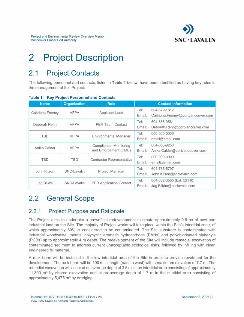
2 Project Description 2.1 Project Contacts The following personnel and contacts, listed in Table 1 below, have been identified as having key roles in the management of this Project:
Table 1: Key Project Personnel and Contacts Name Organization Role Contact Information
Caitriona Feeney VFPA Applicant Lead Tel: 604-679-1812 Email: [email protected]
Deborah Renn VFPA PER Team Contact Tel: 604-665-9561 Email: [email protected]
TBD VFPA Environmental Manager Tel: 000-000-0000 Email: [email protected]
Anika Calder VFPA Compliance, Monitoring and Enforcement (CME)
Tel: 604-665-9253 Email: [email protected]
TBD TBD Contractor Representative Tel: 000-000-0000 Email: [email protected]
John Kitson SNC-Lavalin Project Manager Tel: 604-785-5797 Email: [email protected]
Jag Bilkhu SNC-Lavalin PER Application Contact Tel: 604-662-3555 (Ext: 52110) Email: [email protected]
2.2 General Scope
2.2.1 Project Purpose and Rationale The Project aims to undertake a brownfield redevelopment to create approximately 0.5 ha of new port industrial land on the Site. The majority of Project works will take place within the Site’s intertidal zone, of which approximately 80% is considered to be contaminated. The Site substrate is contaminated with industrial woodwaste, metals, polycyclic aromatic hydrocarbons (PAHs) and polychlorinated biphenyls (PCBs) up to approximately 4 m depth. The redevelopment of the Site will include remedial excavation of contaminated sediment to address current unacceptable ecological risks, followed by infilling with clean engineered fill material.
A rock berm will be installed in the low intertidal area of the Site in order to provide revetment for the development. The rock berm will be 100 m in length (east to west) with a maximum elevation of 7.7 m. The remedial excavation will occur at an average depth of 3.5 m in the intertidal area consisting of approximately 11,300 m3 by shored excavation and at an average depth of 1.7 m in the subtidal area consisting of approximately 5,475 m3 by dredging.

Project and Environmental Review Overview Memo Vancouver Fraser Port Authority
Internal Ref: 677011-0000-30RA-0002 › Final › V4 September 2, 2021 | 3 © 2021 SNC-Lavalin Inc. All Rights Reserved. Confidential.
The excavation will be backfilled with engineered fill, which will be compacted after placement. Engineered fill will also be placed on the upland area of the Site. The finished surface of the Site will be graded gravel.
2.2.2 Project Setting
2.2.2.1 Project Location The Project is located at 2089 to 2095 Commissioner Street, Vancouver, BC, on the southern shoreline of the Central Vancouver Harbour, within the Burrard Inlet, at the Former Sterling Shipyard. The Site has an area of approximately 1.1 ha and is located within port authority jurisdiction in the northern portion of the City of Vancouver, BC. The Site comprises of an upland terrestrial area, an intertidal beach area and a subtidal water lot. The coordinates of the Site are presented in Table 2 below.
Table 2: Project Coordinates Latitude Longitude
49° 17' 12.5" N 123° 03' 52.7" W
Please refer to Figure B in Section 3.1 for the Project location and Appendix II for Site plans.
2.2.2.2 Project Area The Project is located within a “Port Terminal” land use designation within the Burrard Inlet South Shore planning area under the VFPA Land Use Plan. The Project is located along the south shore at the foot of Victoria Drive N, on the north side of Commissioner Street, just north of the City of Vancouver’s Grandview-Woodland neighbourhood. Areas designated under “Port Terminal” land use are primarily associated with deep-sea marine and river terminals that handle a variety of cargo, as well as cruise passengers. The land use also includes primary trade-related uses that support shipping, transportation of goods and passengers, and handling of goods. Ancillary uses may include offices, storage areas, caretaker facilities, and other uses required to support the primary use. A railway operated by Canadian Pacific Railway runs east to west approximately 100 m southeast of the Site, isolating the subject site from the residential and commercial areas located to the south of the Project. It is located within the port authority’s East Vancouver Port Lands committee area.
The Site is located between the existing Lafarge Ready Mix concrete plant which is east of the Site and former Marco Marine Container Inc. (Marco; which is west of the Site), with Pacific Elevators Terminal located further to the west. Table 3 presents the features and properties that are adjacent to and bound the Site.

Project and Environmental Review Overview Memo Vancouver Fraser Port Authority
Internal Ref: 677011-0000-30RA-0002 › Final › V4 September 2, 2021 | 4 © 2021 SNC-Lavalin Inc. All Rights Reserved. Confidential.
Table 3: Features and Properties Neighboring the Site
Direction Feature or Property Distance
North Burrard Inlet Adjacent
East Lafarge Ready Mix concrete plant Adjacent
South Port authority Grounds, CP Railway Adjacent
Commissioner Street Adjacent
CP Railway 50 m
West
Former Marco Site1 Adjacent
Parking Area1 Adjacent
Pacific Elevators Terminal 160 m
West Coast Reduction plant 350 m 1 – Please refer to Section 2.2.2.2.1.
2.2.2.2.1 Lease Areas
A number of leas areas exist within the Site and the parking area adjacent to the west of the Site. Table 4 below identifies the lease areas. The lease areas are also depicted in Figure C.
Table 4: Lease Areas Within and Adjacent to the Site
Location Lease holder Area Description
Within the Site Lafarge Canada Inc. Covering the Site’s southern and eastern limits adjacent to
Commissioner Street and Lafarge Ready Mix concrete plant.
West Coast Reduction Ltd. East of Victoria Drive N, covering the majority of the southern upland area of the Site.
Within parking area (West of the Site)
Columbia Containers Ltd. Northeast of Victoria Drive N, covering the northeast corner of the parking area.
Viterra Canada Inc. On the west side of Victoria Drive N, covering the southwest corner of the parking area.
2.2.2.2.2 City of Vancouver Zoning
City of Vancouver commercial, residential and industrial zoning districts are present within 500 m of the Project. Table 5 lists the zoning districts within 500 m of the Project, as designated under the City of Vancouver’s Zoning and Development By-law 3575.

Project and Environmental Review Overview Memo Vancouver Fraser Port Authority
Internal Ref: 677011-0000-30RA-0002 › Final › V4 September 2, 2021 | 5 © 2021 SNC-Lavalin Inc. All Rights Reserved. Confidential.
Table 5: City of Vancouver Zoning Districts within 500 m of the Site Vancouver Zoning Code Zoning Description Location
CD-1 Comprehensive Development District Zone › Semlin Drive, between Triumph Street and Franklin Street.
M-2 Industrial › Mixed Industrial area south of the Canadian Pacific Railway.
RS-1 One-Family Dwelling › Cambridge Park and Oxford Park. › Pandora Park. › Trinity Park.
RM-3A Multiple Dwelling › Approximately 180 m east of the Site, bound by the Canadian
Pacific Railway to the north and East Hastings Street to the south.
C-2 Commercial › Approximately 140 m southeast of the Site, at Dundas Street and Lakewood Drive.
I-2 Industrial › Approximately 100 m south of the Site, adjacent to the south side of the Canadian Pacific Railway.
MC-1 Industrial › Approximately 480 m south of the Site, along the south of East Hastings Street.
MC-2 Industrial › Approximately 480 m south of the Site, along the north of East Hastings Street.
2.2.2.2.3 Industrial Areas
The municipally-zoned industrial properties within 500 m of the Site to the south are industrial in nature, located within I-2, M-2, MC-1 and MC-2 zoning districts. These industrial areas extend beyond 500 m of the Site to the south (refer to Table 5). Additionally, properties within VFPA jurisdiction, within 500 m of the Site, are designated as Port Terminal land use as per the VFPA Land Use Plan. This land use designation includes industrial uses in support of shipping and transportation operations.
2.2.2.2.4 Sensitive Receptors
For the purposes of this section, sensitive receptors are defined as physical areas with human use and socioeconomic value that may experience impacts as a result of the Project. The Project is located in proximity to densely populated and highly utilized areas of Vancouver. Potential impacts, such as impacts to air quality, visual quality and impact from noise, have been considered. Table 6 below lists sensitive receptors have been identified in proximity to the Project.

Project and Environmental Review Overview Memo Vancouver Fraser Port Authority
Internal Ref: 677011-0000-30RA-0002 › Final › V4 September 2, 2021 | 6 © 2021 SNC-Lavalin Inc. All Rights Reserved. Confidential.
Table 6: Sensitive Receptors in Proximity to the Project Sensitive Area Location Notes Residential Areas Multiple Dwelling (RM-3A) and One-Family Dwelling (RS-1) zoned areas
Approximately 150 m southeast of the Site, adjacent to the south side of the Canadian Pacific Railway
Multiple Dwelling (RM-3A) zoning comprises the majority of the residential area. The residentially zoned area is located to the east of the Site.
Parks and Community Centres
Cambridge Park and Oxford Park
Approximately 150 m southeast of the Site
Under RS-1 Zoning. These two parks are adjoined. Cambridge Park also hosts a community garden (Wall Street Community Garden).
Pandora Park Approximately 480 m southeast of the Site
A larger recreational area of approximately two city blocks. Located within RS-1 Zoning. Pandora Park also hosts a community garden.
Trinity Park Approximately 467 m northeast of the Site
A small residential park, located adjacent to the south side of the Canadian Pacific Railway within RS-1 zoning.
Kiwassa Neighbourhood House
2425 Oxford Street, approximately 640 m east of the Site Community Centre.
Schools
Xpey’ Elementary School 1950 East Hastings Street, approximately 660 m south of the Site
Located within Two-Family Residential (RT-5) Zoning.
Tillicum Annex 2450 Cambridge Street, approximately 670 m east of the Site
Located within One-Family Dwelling (RS-1) Zoning.
Templeton Secondary School
727 Templeton Drive, approximately 1 km south of the Site
Located within Two-Family Residential (RT-5) Zoning.
Hastings Elementary School
2625 Franklin Street, approximately 1 km southeast of the Site
Located within One-Family Dwelling (RS-1) Zoning.
2.2.3 Project Potential Impacts Potential impacts associated with the Project are currently being studied by SNC-Lavalin. Specific studies have been conducted to assess baseline conditions and potential impacts resulting from Project Works (please refer to Section 2.2.4 for more information). The following subsections identify potential impacts to land, water, air and adjacent communities and business that are anticipated as a result of the Project.
2.2.3.1 Land The Project modifies land fully within port authority jurisdiction. Impacts to land beyond the Site and adjacent industrial area are not anticipated. The following potential impacts have been identified for the Site:
› Temporary access disruptions to neighboring sites may occur during some phases of construction.
› Vegetation removal activities are expected to have impacts to the local habitat:

Project and Environmental Review Overview Memo Vancouver Fraser Port Authority
Internal Ref: 677011-0000-30RA-0002 › Final › V4 September 2, 2021 | 7 © 2021 SNC-Lavalin Inc. All Rights Reserved. Confidential.
− Approximately 1,100 m2 of vegetation, currently comprised of Black Cottonwood trees (Populus balsamifera trichocarpa), as well as native and invasive shrubbery, will be removed as part of the Project.
− Vegetation removal will remove potential nesting and foraging habitat for local bird species, as well as potential foraging habitat for bat species such as the Little Brown Myotis (Myotis lucifugus).
− Further details on potential Project impacts on terrestrial habitat are available in the Habitat Assessment prepared by SNC-Lavalin for this Project (Document No. 677011-0000-4ERA-0001; Appendix III).
Mitigations and controls to prevent impacts to wildlife and species at risk are presented in the Project Construction Environmental Plan (CEMP) (Document No. 677011-0000-4ERA-0003; Appendix IV).
2.2.3.2 Water The Project is expected to have temporary effects on water quality and permanent effects on aquatic conditions within the affected portion of Vancouver Harbour. Baseline conditions on the Site including marine habitat and species at risk, as well as potential Project impacts, are discussed in the Habitat Assessment Report for the Project (Appendix III). Project effects are not anticipated to occur beyond the Project Site. The following potential impacts to water have been identified for the Site:
› Approximately 3,500 m2 of Intertidal and subtidal land will be permanently elevated to create new land, removing fish habitat.
› Approximately 1,100 m2 of marine riparian vegetation will be removed as part of the Project, potentially affecting the quality of fish habitat within Vancouver Harbour.
› Potential water quality impacts may occur during remedial excavation, dewatering and backfilling activities.
› Potential impacts to marine mammal species in Vancouver Harbour may occur as a result of noise-generating Project activity.
› Potential death of fish from impacts to water quality, use of machinery, dewatering and other construction activities may occur.
A comprehensive CEMP has been developed for the Project in order to avoid, minimize and mitigate potential Project impacts to water. Mitigations and controls in the CEMP include measures to prevent impacts to water quality and death of fish. This information is provided in full in the Project CEMP (Appendix IV).
2.2.3.3 Air Impacts to air quality are anticipated to be minor and temporary in nature and are not expected to occur beyond the immediate project vicinity. The following potential effects on air quality are anticipated:
› Temporary air quality impacts from machinery operating during Construction.
› Temporary air quality impacts occurring from the generation of fugitive dust during excavation, sediment transportation and infilling activities.
Mitigations and controls to prevent impacts to air quality from machinery and construction activities are presented in the Project CEMP prepared by SNC-Lavalin (Appendix IV).
Project and Environmental Review Overview Memo Vancouver Fraser Port Authority
Internal Ref: 677011-0000-30RA-0002 › Final › V4 September 2, 2021 | 8 © 2021 SNC-Lavalin Inc. All Rights Reserved. Confidential.
2.2.3.4 Adjacent Communities and Businesses Impacts to nearby residential communities are not expected to occur but have been considered as part of Project planning. Additionally, due to the Site being adjacent to currently operational facilities, some impacts to neighbouring businesses have the potential occur. The following potential effects on adjacent communities and businesses are anticipated:
› Temporary disruption to access to neighboring sites due to ongoing construction activity.
› Temporary increase in suspended dust and vehicular exhaust affecting properties neighbouring the Site during construction.
› Temporary increase in baseline noise affecting properties neighbouring the Site during construction.
› Temporary disruption of neighboring site activities due to air quality, noise impacts, and access disruption during construction.
› Temporary minor impacts on air quality and noise affecting nearby residential areas (approximately 150 m southeast of the Site) during construction.
› Impacts to sensitive receptors identified in Section 2.2.2.2.4 are anticipated to be minor, with temporary impacts on air quality and noise occurring during construction activities. Impacts are anticipated to be minor due to the distance buffer between the Site and sensitive receptors and the active adjacent industrial activities (e.g., Lafarge, Marine terminals, CP Rail) ongoing near the Site.
2.2.4 Project Studies Various environmental and socioeconomic components with potential to be affected by the Project have been evaluated by SNC-Lavalin. Section 4 contains required studies and reports that have been prepared for this Project.
2.3 Construction
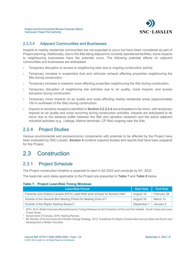
2.3.1 Project Schedule The Project construction timeline is expected to start in Q2 2022 and conclude by Q1, 2023.
The least-risk work dates applicable to the Project are presented in Table 7 and Table 8 below.
Table 7: Project Least-Risk Timing Windows Least-Risk Period Start Date End Date
Fisheries and Oceans Canada (DFO) Least-Risk work window for Burrard Inlet1 August 16 February 28
Outside of the General Bird Nesting Period for Nesting Zone A12 August 16 March 14
Outside of the Raptor Nesting Season3 September 1 January 4 1 DFO. 2014. British Columbia Marine/Estuarine Timing Windows for the Protection of Fish and Fish Habitat - South Coast and Lower
Fraser Areas. 2 Government of Canada. 2018. Nesting Periods. 3 BC Ministry of Environment and Climate Change Strategy. 2013. Guidelines for Raptor Conservation during Urban and Rural Land
Development in British Columbia

Project and Environmental Review Overview Memo Vancouver Fraser Port Authority
Internal Ref: 677011-0000-30RA-0002 › Final › V4 September 2, 2021 | 9 © 2021 SNC-Lavalin Inc. All Rights Reserved. Confidential.
Table 8: Gantt Chart for Least-Risk Project Construction Periods Period Dec Jan Feb Mar Apr May Jun Jul Aug Sep Oct Nov
DFO Least-risk window
General Bird Nesting period
Raptor Nesting Season
Unshaded areas represent least-risk periods
Initial Site preparation and construction activities are planned start outside of least-risk periods. Ground disturbance activities (e.g., vegetation removal, wood debris removal) will not commence until a silt curtain has been installed around the work area. Vegetation/tree removal activities will not commence within the general nesting period prior to a songbird nesting survey conducted by a Qualified Environmental Professional. Additionally, if raptors are observed within 200 m of the Site, appropriate no-disturbance buffers will be established.
In-water works will be kept within the DFO least-risk work window for Burrard Inlet as much as possible. Due to the long-term nature of the Project, in-water works outside the least-risk window may occur. In-water works will not occur until a fish salvage has been completed by a Qualified Environmental Professional. If in-water works are planned outside of the DFO least-risk period, additional monitoring and mitigation measures will be implemented to prevent impacts to species during sensitive life stages, at the discretion of the Project Environmental Monitor. Vegetation clearing and noise-generating activity will be coordinated to take place outside of bird and raptor nesting seasons as much as feasible. In the event that nesting periods cannot be accommodated, additional mitigation measures will be implemented to minimize impacts. Please refer to the Project CEMP for sensitivity-period related mitigations (Appendix IV).
2.3.2 Project Construction Activities A detailed assessment of design options was undertaken by SNC-Lavalin in February 2021 (Document No. 677011-1000-4PEN-0002; Appendix V) to determine the most feasible and lowest risk Project approach. Several options were considered for revetment prior to remediation, including:
› An anchored Combi-wall embedded into the seabed;
› A tubular piled perimeter wall embedded into the seabed;
› A rock berm on top of the seabed; and
› A rock berm on top of the seabed with a sheet pile wall embedded into the seabed.
Following geotechnical investigation, options involving pile-driving and walls embedded into the Site substrate were considered not practical due to dense till presence limiting the feasibility of pile driving. Additionally, options involving embedded infrastructure were assessed to have less sustainability value and higher risk level. As a result, the rock berm revetment option was chosen as the most feasible design option and for Site isolation.
Installation of the rock berm will require initial dredging with marine equipment in order to remove a layer of liquefiable sand from the footprint of the rock berm in order to provide stability. Dredge material is planned to be loaded to barges for disposal. Following initial dredging, rock berm material is planned to be lowered down to the seafloor from barges in order to construct the rock berm. After rock berm installation, all subsequent works are anticipated to take place from land, continuing to load excavated onto barges from land, later to be unloaded on the Site or transported directly to an approved disposal facility. Following rock

Project and Environmental Review Overview Memo Vancouver Fraser Port Authority
Internal Ref: 677011-0000-30RA-0002 › Final › V4 September 2, 2021 | 10 © 2021 SNC-Lavalin Inc. All Rights Reserved. Confidential.
berm installation, remedial excavation of substrate will take place, followed by backfilling and vibro compaction of the Site surface.
Based on information available as of the date of this report, the following Project scope is anticipated:
1) Site Preparation.
2) Rock Berm Construction.
3) Dredging.
4) Sediment Remediation.
5) Backfilling and Grading.
6) Habitat Offsetting.
2.3.2.1 Project Scope The following scope is anticipated for the Project.
2.3.2.1.1 Site Preparation
The following tasks are anticipated for Site preparation:
› Establishment of Site access points and routes;
› Removal of trees and other vegetation on the southern portion of the Site;
› Establishment of laydown, stockpiling, equipment storage and any other areas required for Project works (refer to Figure A);
› Installation of erosion and sediment control measures where applicable;
› Installation of a silt curtain around the in-water work area;
› Establishment of water quality monitoring sites upstream and downstream of the work area;
› Demolition of existing infrastructure;
› Mobilization of machinery, materials and equipment onto the Site; and
› Initial dredging up to a depth of 3 m within the in-water work area to provide clearance for barges, if determined to be necessary.
2.3.2.1.2 Rock Berm Installation
The following tasks are anticipated for rock berm installation:
› Initial dredging/excavation of liquefiable sand layer from footprint of the proposed rock berm:
− Initial dredging is to take place from barge.
› Installation of rock berm revetment:
− Lowering of stones from barge into footprint.

Project and Environmental Review Overview Memo Vancouver Fraser Port Authority
Internal Ref: 677011-0000-30RA-0002 › Final › V4 September 2, 2021 | 11 © 2021 SNC-Lavalin Inc. All Rights Reserved. Confidential.
2.3.2.1.3 Sediment Remediation
The following tasks are anticipated for remedial excavation:
› Excavation of substrate from the intertidal and subtidal area of the Site, up to an average depth of 3.5 m below Site grade;
› Excavation is to take place in wetted conditions from both barge and land;
› Sampling and testing of excavated substrate;
› Management of dredge decant water; and
› Disposal of contaminated substrate.
2.3.2.1.4 Backfilling and Grading
The following tasks are anticipated for backfilling and grading:
› Placement of engineered fill on the Site:
− Backfilling the excavation site with 41,000 m3 of engineered fill; and
− Placement of additional engineered fill to elevate Site grade to approximately 6 m elevation.
› Grading and compaction of the newly placed engineered fill.
Please refer to Site plans in Appendix II for Site Plans depicting the approximate limits of the Project.
2.3.2.1.5 Habitat Offsetting
After Project completion, habitat offsetting will be implemented for the Project. A Habitat Offsetting Plan has been prepared (Document No. 677011-0000-4EER-0002; Appendix VI) and will be implemented as part of permit application under the federal Fisheries Act and VFPA’s PER process. Habitat offsetting will follow guidelines from Fisheries and Oceans Canada (DFO) and input from the port authority in order to create new fish habitat on the Site to compensate for fish habitat lost as a result of the Project, as well as riparian vegetation loss resulting from the Project.
Habitat offsetting is anticipated to take place on site in the form of Habitat Restoration and Enhancement. The Habitat Offsetting Plan will include specific offsetting measures, their specifications, and their methodology of implementation. In addition, a comprehensive monitoring program has been developed and will be implemented in order to manage the inherent uncertainties associated with habitat restoration and establishment.
Habitat offsetting will also follow consultation with the port authority, First Nations representatives and other stakeholders. Specific details, considerations and rationale of habitat offsetting are discussed in the Habitat Offsetting Plan (Appendix VI).
2.4 Marine Construction & Staging Plan The Project involves work in water, potentially from barges with support from other small construction vessels and includes the installation of a rock berm in the subtidal zone of the Site. Therefore, some navigation-related hazards may exist for the Project. The following subsections present the marine construction items have been taken into consideration for these works.
Project and Environmental Review Overview Memo Vancouver Fraser Port Authority
Internal Ref: 677011-0000-30RA-0002 › Final › V4 September 2, 2021 | 12 © 2021 SNC-Lavalin Inc. All Rights Reserved. Confidential.
2.4.1 Navigation-related Hazards and Risk Mitigation A detailed assessment of navigation-related risks has not been conducted. Significant navigational risks are not anticipated due to the nature of vessels to be used during the Project (standard construction barges) and the nature of the Site (near-shore and recessed inland, far from navigational routes).
Prior to construction, the Contractor will develop their workplan in consideration of navigational hazards, including the identification of potential risks and associated mitigation measures.
2.4.2 Staging and Construction Areas The Project is anticipated to involve work from marine equipment within the intertidal and shallow subtidal zones of the Site. It is assumed that barges loaded with dredge material would require minimum of 3 m water depth, which will require work within high-tide periods for the initial rock berm installation activities, if dredge spoil is to be loaded onto barges. Installation of the rock berm will require initial dredging from marine equipment to remove liquefiable sand from the rock berm footprint, which can be reached during reasonable tidal work windows. Following dredging, the revetment will be constructed from barge. The excavation south of the revetment may be completed from either land or barge. Equipment is anticipated to be a combination of land and barge-based equipment. Additionally, dredging to 3 m depth in order to provide access for barges for work during low-tide levels is currently being considered.
Staging, laydown, stockpiling and construction office areas are proposed to be located both within the Site and immediately to toe west of the Site, within the former Macro site and parking area, overlapping with locations leased to the parties identified in Section 2.2.2.2.1. Figure A below depicts the anticipated temporary land uses for the Project.

PROPERTY LINE
SEWER
OUTFALL
SHEET PILE WALL
P
K
3
M
3
4
4
1
B
W
A
L
L
S
T
R
E
E
T
C
O
M
M
I
S
S
I
O
N
E
R
S
T
R
E
E
T
2
3
STRATA LOT 1 TO 68
TE
MP
DE
WA
TE
RIN
G/W
AS
TE
WA
TE
R S
YS
TE
M
15m
x(35-50)m
TE
MP
S
TO
RA
GE
25m
X75m
HAZARDOUS
WASTE
50mx50m
OF
FIC
E
30m
x20m
LAYDOWN
30mx30m
TEMP STORAGE
FOR BACKFILL
50mx50m
EXCAVATION BOUNDARY
STERLING SHIPYARD
SITE BOUNDARY
PROJECT BOUNDARY
No. Date Dr'n Ch'dREVISION
REV.
DESIGN BY
DRAWN BY
DATE
SCALE
VFPA SITE
Ref. No. R E F E R E N C E
SIZE
D
SHEET
TIT
LE
B
LO
CK
: D
L-T
B.dw
g
DA
TE
: 2021/08/27 - 1:20pm
PA
TH
: Q
:\677011 S
terling S
hipyard R
&R
\40_E
xecution\45_G
IS
_D
wgs\M
A-M
arine\\20-191-G
A-003.dw
g
APPROVED
DWG.
VANCOUVER FRASER PORT AUTHORITY
ENGINEERING DEPARTMENT
vancouver
PORT of
STERLING SHIPYARD REMEDIATION & INFILL
CONCEPTUAL CONTRACTOR PLANT LAYOUT
070-191-GA-003
1 of X PB
-
J. GENG
-
2021-MAY-12
AS SHOWN
VAN 070
0 500001:750
- -
PRELIMINARY
677011
N
1:750
PLAN
NOTES:
1. FOR GENERAL NOTES, SEE DWG 20-191-GA-001.
2. ELEVATIONS ARE IN METRES, TO CHART DATUM CITY OF VANCOUVER
MONUMENT V-2901 LOCATED AT THE INTERSECTION OF VICTORIA
DRIVE AND COMMISSIONER STREET.
ELEVATION = 8.316m (CHART DATUM),
5.271m (GEODETIC DATUM).
3. CHART DATUM = CVD28GVRD GEODETIC DATUM + 3.045m
4. ASSUME 20% OF THE CONTAMINATED SEDIMENT (EXCAVATED OR
DREDGED) WILL NEED TO BE TRANSPORTED AND DISPOSED OF AS
HAZARDOUS WASTE. THE REMAINING 80% WILL EXCEED THE
PROVINCIAL CONTAMINATED SITES REGULATION (CSR)
COMMERCIAL/INDUSTRIAL LAND USE STANDARDS
PROPERTY LINE
SITE BOUNDARY
LEGEND:
PA 21/05/12 ISSUED FOR 60% REVIEW
PRIORITY 1 AREAS
PRIORITY 2 AREAS
PRIORITY 3 AREAS
PROPOSED EXCAVATION LIMITS
PROJECT BOUNDARY
ISSUED FOR 90% REVIEWPB 21/08/XX

Project and Environmental Review Overview Memo Vancouver Fraser Port Authority
Internal Ref: 677011-0000-30RA-0002 › Final › V4 September 2, 2021 | 14 © 2021 SNC-Lavalin Inc. All Rights Reserved. Confidential.
2.4.3 Dates and Hours of Operations Where possible, all construction activity is anticipated to take place during standard construction hours, in adherence to the City of Vancouver’s Noise Control By-law 6555, and the port authority’s Project & Environmental Review Guidelines – Construction Outside of Regular Work Hours (VFPA, 2021). Work is expected to occur between 7:00 AM to 8:00 AM Monday to Saturday, with no work permitted on Sundays or holidays. It is recognized that construction activity will need to occur when the tidal conditions are appropriate. Therefore, work outside of these guidelines may be required. Construction is not anticipated to occur on Sundays or during holidays. Any deviations from the permitted construction times will be requested for approval by the port authority prior to construction. Construction work will follow VFPA’s Noise Guidelines and any requests to work outside of the designated work hours will be requested as per VFPA’s Project & Environmental Review Guidelines – Construction Outside of Regular Work Hours (VFPA, 2021). A noise assessment screening worksheet has been completed as part of the Project PER application (Appendix VII).
2.4.4 Description of Activities Taking Place Marine-based activities are anticipated to include the following:
› Dredging from barge;
› Moving operations in and out of containment enclosures and/or moving such enclosures (silt curtains or release controls);
› Dredging from land;
› Loading and transportation of dredge material via barges (if employed as a method of dredge material disposal);
› Remediation confirmation sampling and other environmental impact monitoring and inspection activities (as discussed in the Project CEMP);
› Post-dredging survey prior to rock berm construction;
› Construction of rock berm; and
› Infilling.
Please refer to Section 2.3.2 for an overview of proposed construction activities.
2.4.5 Equipment and Vessel Sizes Marine construction activities will take place within the Site’s intertidal and subtidal zone from marine-based equipment as well as from land.
At the present time, specifications relation to vessel sizes are not known. Vessels beyond standard construction barges with capacity to operate a clamshell dredger are not anticipated to be required. The following subsections identify marine construction-related equipment is anticipated to be used during the Project.

Project and Environmental Review Overview Memo Vancouver Fraser Port Authority
Internal Ref: 677011-0000-30RA-0002 › Final › V4 September 2, 2021 | 15 © 2021 SNC-Lavalin Inc. All Rights Reserved. Confidential.
2.4.5.1 Marine-Based Equipment The following equipment will operate within water for the following activities:
› Transportation barges (minimum of 2):
− A minimum of one (1) barge to be loaded with dredge material throughout initial dredging and intertidal excavation; and
− One (1) barge to be loaded with rock for the construction of the rock berm.
› Barge with mounted clamshell dredger (1):
− For the Initial dredging of rock berm footprint and intertidal dredging/excavation.
› Barge with mounted crane (1):
− For lowering of rocks into rock berm footprint.
› Boat (1):
− For the installation of the silt curtain between the work area and Burrard Inlet;
− For personnel changes;
− For water quality sampling, monitoring/inspections; and
− For maintenance of the silt curtain.
2.4.5.2 Land-based Equipment The following equipment will be based on land, but will operate in water for the following activities:
› Clamshell dredger (1):
− Land-based dredging of wetted portion of intertidal zone.
› Excavator (minimum of 1):
− Remedial excavation within dry portions of intertidal zone;
− Remedial excavation of wetted portions of intertidal zone; and
− Backfilling.
› Morooka carriers;
› Vibrocompaction equipment (a downhole vibrator):
− Crawler crane may be required.
2.4.6 Marine Communication Prior to construction, the Contractor will develop their workplan in consideration of navigational hazards, including the identification of potential navigational risks and a communication protocol. It is anticipated the Contractor will utilize radio communication prior to vessel movements where vessels unrelated to the Project have the potential to be present.

Project and Environmental Review Overview Memo Vancouver Fraser Port Authority
Internal Ref: 677011-0000-30RA-0002 › Final › V4 September 2, 2021 | 16 © 2021 SNC-Lavalin Inc. All Rights Reserved. Confidential.
3 Drawing Requirements This section outlines the requirements for the drawings submitted as part of this PER application.
3.1 Location Plan Plan showing the relationship of the proposed Project to surrounding area at a 1:5000 scale. The relationship of the proposed Project to the surrounding area (Location Plan) can be found in Figure B below:

Project and Environmental Review Overview Memo Vancouver Fraser Port Authority
Internal Ref: 677011-0000-30RA-0002 › Final › V4 September 2, 2021 | 17 © 2021 SNC-Lavalin Inc. All Rights Reserved. Confidential.
Figure B: Location Plan

Project and Environmental Review Overview Memo Vancouver Fraser Port Authority
Internal Ref: 677011-0000-30RA-0002 › Final › V4 September 2, 2021 | 18 © 2021 SNC-Lavalin Inc. All Rights Reserved. Confidential.
3.2 Site Plans The following Site Plans have been developed for this PER application:
› Site Plan.
› Marine or in-water Structures.
› Lot Grading and Utilities.
Site Plans that illustrate the location and dimensions of all existing and proposed structures and marine structures can be found in Appendix II.
3.3 Access Construction of permanent roadways/driveways are not proposed for this Project. All land access/egress will take place via accessing Victoria Drive N from Commissioner Street. Figure C below shows the proposed access route.

Project and Environmental Review Overview Memo Vancouver Fraser Port Authority
Internal Ref: 677011-0000-30RA-0002 › Final › V4 September 2, 2021 | 19 © 2021 SNC-Lavalin Inc. All Rights Reserved. Confidential.
Figure C: Site Access and Egress

Project and Environmental Review Overview Memo Vancouver Fraser Port Authority
Internal Ref: 677011-0000-30RA-0002 › Final › V4 September 2, 2021 | 20 © 2021 SNC-Lavalin Inc. All Rights Reserved. Confidential.
3.4 Vegetation Plan The Habitat Assessment Report found in Appendix III, lists existing trees and vegetation types (including listed plant species, biodiversity/species richness, invasive species types and relative abundance). At the time of this memo, it is anticipated that tree removal will take place at the southern portion of the Site. Approximately 24 small-to-medium and large black cottonwood trees will be removed, including 13 large mature trees. Additionally, approximately 15 small (under 6 m in height with a diameter of under 7 cm) cottonwood trees are anticipated to be removed by grubbing.
Further details on vegetation management, including a mitigation plan, are provided in the Project Construction Environmental Management Plan (Appendix IV). No replanting is currently being considered. The Project CEMP also contains details about monitoring and management of invasive vegetation on the Site.

Project and Environmental Review Overview Memo Vancouver Fraser Port Authority
Internal Ref: 677011-0000-30RA-0002 › Final › V4 September 2, 2021 | 21 © 2021 SNC-Lavalin Inc. All Rights Reserved. Confidential.
4 Required Studies and Reports A number of required studies and reports have been completed in support of this Project and the PER Application. Reference is provided in the subsections below.
4.1 Geotechnical Report A geotechnical report has been completed the describes the site seismic and geologic hazards. The Geotechnical Report can be found in Appendix VIII.
4.2 Traffic Management Plan The Traffic Management Plan (TMP) outlines the traffic control procedures and requirements for the Project. The TMP must be executed by a qualified Traffic Control Company and any field adjustments to the plan shall be made by qualified personnel. Details outlined in the TMP shall be reviewed and updated by the prime contractor (Contractor), per contract requirements once the construction contract is awarded. The TMP can be found in Appendix IX.
4.3 Noise Study Noise resulting from construction, demolition or nonroutine maintenance activities are addressed through the Project CEMP. A Noise Assessment Screening Worksheet was completed for the Project and can be found in Appendix VI.
The assessment of future potential use (i.e., development of a terminal or industrial facility) was not within the scope of this assessment. Therefore, potential impacts resulting from post-construction operational noise were not considered.
4.4 Archaeological Overview Assessment (AOA) Project activities, such as excavation, infilling, and grading have the potential to alter undocumented archaeological sites that may be located within the Project area. An Archaeological Overview Assessment (AOA) was conducted for the Project in order to identify areas of archaeological potential and guide potential subsequent archaeological investigations recommended for the project area. The AOA can be found in Appendix X.
4.5 Construction Environmental Management Plan A Construction Environmental Management Plan has been developed for the Project in order to provide guidance, mitigations, and best practices to be followed and undertaken for the planned remedial excavation and backfilling works at the Former Sterling Shipyard. The CEMP has been prepared in accordance with Project & Environmental Review Guidelines, provincial and federal best management practices (BMPs), as well as SNC-Lavalin’s knowledge of environmental mitigations and understanding of the proposed Project scope. The CEMP can be found in Appendix IV. Mitigations and practices around Waste Management and Soil and Water Management are included in the Project CEMP. In addition, the

Project and Environmental Review Overview Memo Vancouver Fraser Port Authority
Internal Ref: 677011-0000-30RA-0002 › Final › V4 September 2, 2021 | 22 © 2021 SNC-Lavalin Inc. All Rights Reserved. Confidential.
Contractor will be responsible for developing detailed Environmental Protection Plans (EPP)s and Component Plans for specific activities, including Soil/Substrate Management, and Dredge and Excavation Water Management (including Dewatering).
Requirements of Contractor EPP and Component Plan contents to be developed and implemented by the Contractor are identified in the Project CEMP.
4.6 Habitat Assessment A Habitat Assessment Report has been completed for the Project and can be found Appendix III. This report includes an assessment of baseline conditions, species at risk and invasive species associated with the terrestrial, intertidal and subtidal portions of the Site.
4.7 Flood Protection The Design Water Level (DWL), which accounts for astronomical tide, storm surge and sea level rise (SLR) over the 50-year Project life, as well as the Flood Construction Level (FCL), are summarized in the Marine Design Criteria (677011-0000-4PEC-0001) and can be found in Appendix XI. The DWL does not include wave effects due to wave-structure or wave-shoreline interaction, such as wave run-up or overtopping.

Project and Environmental Review Overview Memo Vancouver Fraser Port Authority
Internal Ref: 677011-0000-30RA-0002 › Final › V4 September 2, 2021 | 23 © 2021 SNC-Lavalin Inc. All Rights Reserved. Confidential.
5 Consultation Requirements This section outlines and describes the consultation requirements associated with the Project. Specific areas of consultation focus are identified in the subsections below.
5.1 Indigenous Groups
5.1.1 Overview of pre-engagement A pre-engagement period was incorporated into the Project in an effort to support VFPA’s commitment to meaningful consultation and to the advancement of reconciliation with Indigenous groups. During pre-engagement, Indigenous groups were invited to provide input and feedback during the early stages of project design. This input was then incorporated into the materials included for submission as part of the Project and Environmental Review (PER) Application.
5.1.1.1 Scope of Indigenous engagement The proposed project falls within the traditional territory of the following Indigenous groups:
› Leq’a:mel First Nation;
› Musqueam Indian Band;
› Seabird Island First Nation;
› Shxw’ow’hamel First Nation;
› S’ólhTéméxw Stewardship Alliance;
› Aitchelitz First Nation;
› Chawathil First Nation;
› Cheam First Nation;
› Kwaw’Kwaw’Apilt First Nation;
› Scowlitz First Nation;
› Shxwha:y Village;
› Skawahlook First Nation;
› Skwah First Nation;
› Skowkale First Nation;
› Soowahlie First Nation;
› Squiala First Nation;
› Sumas First Nation;
› Tzeachten First Nation;

Project and Environmental Review Overview Memo Vancouver Fraser Port Authority
Internal Ref: 677011-0000-30RA-0002 › Final › V4 September 2, 2021 | 24 © 2021 SNC-Lavalin Inc. All Rights Reserved. Confidential.
› Yakweakwioose First Nation;
› Yale First Nation;
› Squamish Nation;
› Tsleil-Waututh First Nation;
› Vancouver Island Groups;
› Cowichan Tribes;
› Halalt First Nation;
› Lyackson First Nation;
› Penelakut Tribe;
› Stz'uminus First Nation; and
› Ts'uubaa-asatx Nation (Lake Cowichan).
Given the location of the project in the Burrard Inlet, focus of pre-engagement was with the following Indigenous groups:
› Musqueam Indian Band;
› Tsleil-Waututh Nation;
› S’ólhTéméxw Stewardship Alliance; and
› Squamish Nation.
5.1.2 Summary of Pre-Engagement activities Engagement with Indigenous groups regarding the proposed project began in December 2020 when Indigenous groups were sent a letter introducing the project. The port authority’s archaeological consultant provided Indigenous groups with a copy of the Archaeological Overview Assessment (AOA) report for review in January 2021. Early meetings with Indigenous groups regarding the project occurred in February and March of 2021.
Due to the confidential nature of the project, including the nature and location of the contamination on site, the port authority required Indigenous groups to sign a Non-Disclosure Agreement (NDA) to receive information during the pre-engagement period. Once an NDA was executed with an Indigenous group, project-related materials were distributed for review and comment.
Project-related materials were sent to those Indigenous groups who had executed an NDA in May 2021. A 45 calendar day comment window was provided. Early draft versions of documents were provided wherever possible to provide Indigenous groups with the opportunity to provide input prior to documents being finalized for submission to PER.
Members of the project team met with Indigenous groups to discuss feedback on the project in July 2021 and formal responses were issued to Indigenous groups, where possible, in August 2021 prior to submission of the application to the PER process. Issues raised by Indigenous groups were in relation to

Project and Environmental Review Overview Memo Vancouver Fraser Port Authority
Internal Ref: 677011-0000-30RA-0002 › Final › V4 September 2, 2021 | 25 © 2021 SNC-Lavalin Inc. All Rights Reserved. Confidential.
the rationale for the project, composition of imported fill, proposed approach to habitat offsetting, impacts to fish and fish habitat, economic benefits, and archaeology and cultural heritage.
During this early engagement process, Indigenous groups provided the project team with feedback in regards to project design. One of these comments was specifically related to the size of the vegetation band at the top of the rock berm, and the request was made for the project team to increase the size of the vegetation band in the next phase of design. In response to this request, the project team was able to alter the design to increase the width of the vegetation band from 2 m to 3 m for the design submitted for review through the PER process.
Engagement with Indigenous groups is ongoing, and the project team continues to seek opportunities to incorporate input provided by Indigenous groups during pre-engagement into the project.
5.1.3 Engagement Activities by Indigenous Group Engagement activities undertaken with each Indigenous group is outlined in further detail in Appendix Appendix XII.
5.2 Public Engagement The proposed Project Site is completely located within the jurisdiction of the port authority. SNC-Lavalin recognizes the longstanding and respectful relationship established between the port authority and the communities adjacent to port lands, represented locally by the East Vancouver Port Lands and Liaison Committee (EVPL) and South Shore Community Liaison Committee.
Engagement with the local community is being undertaken as part of the Project. A copy of the Public Engagement Plan can be found in Appendix XIII. Draft notification materials for public notification (Draft notification postcard, draft print advertisement and draft web content material) can be found in Appendix XIV

Project and Environmental Review Overview Memo Vancouver Fraser Port Authority
Internal Ref: 677011-0000-30RA-0002 › Final › V4 September 2, 2021 | 26 © 2021 SNC-Lavalin Inc. All Rights Reserved. Confidential.
6 Other Requirements/Considerations 6.1 Infrastructure Considerations and Mitigation plan A Geotechnical Instrumentation and Monitoring Plan (GIMP) has been developed for this Project. The purpose of the GIMP is to identify existing adjacent structures and evaluate anticipated impacts resulting from vibration and ground subsidence due to the proposed work. The GIMP specifies monitoring thresholds, monitoring frequencies, development of a response action plan, and reporting requirements. The Project GIMP can be found in Appendix XV.
6.2 Access to the Site It is anticipated that access to the Site to and from Commissioner Street for remediation and construction works and for long-term development will continue to take place according to the current entrance/exit to the site. No additional changes to access are anticipated. Details on traffic management can be found in the Project TMP, located in Appendix IX.

Appendix I PER Application Form

Appendix II Site Plans

Appendix III Habitat Assessment

Appendix IV Construction Environmental Management Plan (CEMP)

Appendix V Revetment Options Memorandum

Appendix VI Habitat Offsetting Plan

Appendix VII Noise Assessment Screening Worksheet

Appendix VIII Geotechnical Report

Appendix IX Traffic Management Plan

Appendix X Archaeology Overview Assessment (AOA)

Appendix XI Marine Design Criteria

Appendix XII Engagement Activities by Indigenous Group

Appendix XIII Public Consultation and Stakeholder Engagement Plan

Appendix XIV Public Consultation – Draft Materials
Appendix XV Geotechnical Instrumentation and Monitoring Plan
SNC-Lavalin Inc. Suite 500, 745 Thurlow Street
Vancouver, British Columbia, Canada V6E 0C5 604.662.3555 604.515.5150
www.snclavalin.com