programs and project management division to: kirtland
TRANSCRIPT

DEPARTMENT OF THE ARMY LOS ANGELES DISTRICT CORPS OF ENGINEERS
P.O. BOX 532711 LOS ANGELES, CALIFORNIA 90053-2325
REPLY TO ATTENTION OF
31 August 2018 Programs and Project Management Division
TO: Kirtland Demolition Bombing Range Technical Project Planning (TPP) Team
Members RE: Final Proposed Plan Remedial Investigation and Feasibility Study of a Formerly Used Defense Site at Kirtland Demolition Bombing Range, Cibola County, New Mexico FUDS Project No. K06NM045301 Dear TPP Team Member, Enclosed is the Final Proposed Plan for the Formerly Used Defense Site known as the Kirtland Demolition Bombing Range, Grants, New Mexico. The Final Proposed Plan will be the subject of a public meeting to be held at the El Malpais Visitor’s Center on Wednesday September 26, 2018 from 4:00 pm to 7:00 pm. I invite you to attend the meeting. If you have any questions concerning the project, please call me at (213) 452-3669. Thank you for your participation. Sincerely, Lu Tan Project Manager Enclosure: Final Proposed Plan

Bering Sea Environmental, LLC - Corporate Office 3601 C Street, Suite 1000-31 Anchorage, Alaska 99503.
(907) 278 - 2311 www.bsenv.com
31 August 2018
U.S. Army Corps of Engineers ATTN: Mr. Lu Tan Los Angeles District (CESPL) 915 Wilshire Blvd. Los Angeles, CA 90017-3401
Subject: Final Proposed Plan Contract W912PL-12-D-0030, Task Order 0002 Remedial Investigation/Feasibility Study (RI/FS) Kirtland Demolition Bombing Range, Cibola County, New Mexico
Dear Mr. Tan,
Bering Sea Environmental, LLC. (BSEn) is pleased to submit the Final Proposed Plan for the
Kirtland Demolition Bombing Range. This report was prepared under U.S. Army Corps of
Engineers (USACE) W912PL-12-D-0030, Task Order 0002.
If you have any questions or comments, please contact me at (757) 775-2212.
Sincerely, Bering Sea Environmental
Patti De La O Project Manager
Enclosure: Final Proposed Plan

Final
Proposed Plan
Kirtland Demolition Bombing Range Cibola County, New Mexico
U.S. Army Corps of Engineers Los Angeles District
and
South Pacific Division Range Support Center
Contract: W912PL-12-D-0030 Delivery Order: 0002
FUDS Project No. K06NM045301
August 2018

This page intentionally left blank.
PROPOSED PLAN KIRTLAND DEMOLITION BOMBING RANGE
Contract No. W912PL-12-D-0030, Delivery Order 002 Page 1 August 2018
1.0 INTRODUCTION This Proposed Plan1 has been prepared for the United States Army Corps of Engineers (USACE)2 to satisfy statutory and regulatory re-quirements for public involvement in the remedy selection process for the munitions response site at the Kirtland Demolition Bombing Range, a for-merly used defense site in Cibola County, New Mexico (Figure 1). Contamination related to mu-nitions and explosives of concern (military mu-nitions) has been identified at the High Explosive Bombing Range (also called MRS01) at Kirtland Demolition Bombing Range. This contamination poses potential hazards to human health. To pro-tect human health and the environment, and to comply with the Comprehensive Environmental Response, Compensation, and Liability Act (CERCLA) (also known as Superfund), USACE must select a remedy to address the munitions hazards identified at Kirtland Demolition Bomb-ing Range. Due to potentially complete munitions exposure pathways, a remedial investigation and feasibil-ity study was recommended. Preparation and dis-tribution of this Proposed Plan follows comple-tion of that remedial investigation and feasibility study and release of the Remedial Investigation and Feasibility Study Report in March 2018. This Proposed Plan describes the site (Sections 2.0 through 6.0), summarizes the USACE’s evalua-tion of different options, called “remedial alterna-tives,” for addressing munitions hazards at the project site (Sections 7.0 and 8.0), and provides the rationale for the USACE’s preferred alterna-tive (Section 9.0). This document also provides an opportunity for the public to participate in the decision process and describes how the public can get involved (Section 10.0). Local community members, land owners, and other interested parties are encour-aged to review this Proposed Plan and submit
1 The terms used in this Proposed Plan are defined in the
glossary at the back of this document and presented in bold italic font at first use.
comments. Comments on the Proposed Plan will be accepted from September 07, 2018 through October 10, 2018, and comments received will be considered before the final selection and approval of a remedial action. Following acceptance of the Proposed Plan, the selected remedy will be rec-orded in a Decision Document.
The USACE is the lead agency for investigating, reporting, making remedial decisions, and taking remedial actions (e.g., cleanup) at Kirtland Dem-olition Bombing Range. In this role, the USACE works with the New Mexico Environment Depart-ment (NMED) and the U.S. Environmental Pro-tection Agency (USEPA). This Proposed Plan is part of USACE’s community relations program, which is a component of the requirements of Sec-tion 117(a) of CERCLA and Section 300.430(f)(2) of the National Oil and Hazardous Substances Pollution Contingency Plan. Supporting information for this Proposed Plan can be found in the Remedial Investigation and Feasi-bility Study Report (Bering Sea Environmental LLC [BSEn] and Parsons Government Services, Inc. [Parsons], 2018), which is part of the admin-istrative record for the project. Further details on the administrative record are provided in Sec-tion 10.0 of this document. The USACE encour-ages the public to review these documents to gain a more comprehensive understanding of the pro-ject site and activities conducted.
2 A list of acronyms and abbreviations used in this docu-ment is presented at the back of this document.
Preferred Alternative It is USACE’s judgment that the preferred alterna-tive identified in this Proposed Plan to protect public health or welfare and the environment from military munitions hazards present within MRS01 is Alter-native 2: Educational Awareness.

PROPOSED PLAN KIRTLAND DEMOLITION BOMBING RANGE
Contract No. W912PL-12-D-0030, Delivery Order 002 Page 2 August 2018
2.0 SITE BACKGROUND SITE HISTORY The U.S. Army acquired 9 square miles of rugged lava field on 31 March 1943 from the Bureau of Land Management (BLM), and on 15 June 1943 from the State of New Mexico and the New Mex-ico–Arizona Land Company. According to the 1996 Archives Search Report, the Kirtland Demolition Bombing Range was used from the latter part of 1942 until May 1944 by bomber aircraft dropping live bombs for the
Army Air Forces bombardier training program. The Archives Search Report indicates that the flight path to the target was potentially northeast to southwest or southwest to northeast, based on the pattern of ordnance and explosives found dur-ing a 1994/1995 removal action. After initial use, Kirtland Army Airfield closed the site because it was too rugged to construct and maintain targets there. Use of the site was transferred to the Second Air Force for aircraft flying out of Clovis and Ala-mogordo, New Mexico; however, it was never used due to the harsh terrain. (USACE, 1996). The land for Kirtland Demolition Bombing Range was transferred to the BLM in 1947. In 1987, the property became part of El Malpais National Monument, which is managed by the National Park Service (NPS). In addition, the area in El Malpais that includes the bombing range site has been designated as recommended wilderness un-der the 1964 Wilderness Act and is managed as natural, undeveloped, and primitive wilderness.
PREVIOUS INVESTIGATIONS Beginning in 1986, numerous munitions removal actions and investigations have been performed at the Kirtland Demolition Bombing Range. Activi-ties included surveying the area, sampling soil, analyzing risks, removing munitions-related de-bris, and detonating unexploded ordnance (100-pound high explosive bombs used for training during World War II, along with associated fuzes). Previous investigations and removal actions were hampered by the dangerous terrain, and personnel working at the site have experienced a high injury rate. As a result, many reports about earlier inves-tigations emphasized the risks to personnel oper-ating on site and have recommended various ap-proaches to reducing those risks. Table 1 summarizes the investigations and re-moval actions that have been completed at the Kirtland Demolition Bombing Range.
PLEASE MARK YOUR CALENDAR! Public Comment Period: From September 07, 2018 through October 10, 2018, USACE will accept written com-ments on this Proposed Plan during the pub-lic comment period. Written comments may be sent to
U.S. Army Corps of Engineers ATTN: Mr. Lu Tan Los Angeles District (CESPL) 915 Wilshire Blvd. Los Angeles, CA 90017-3401
Public Meeting: A public meeting will be held on Wednesday September 26, 2018, at
Northwest New Mexico Visitor’s Center 1900 E. Santa Fe Ave. Grants, NM 87020 505-876-2783
from 4:00 pm to 7:00 pm to explain the Pro-posed Plan and the alternatives presented in the Remedial Investigation and Feasibility Study Report. For more information, see the administra-tive record at the following location:
Grants Public Library 1101 N. First St. Grants, NM 87020

STATE H
WY 1
17
§̈¦40
STA
TE
HW
Y 5
3
ST
AT
E H
WY
117
Grants
San Rafael
McCartys
220000
220000
240000
240000
260000
260000
38
60
00
0
38
60
00
0
38
80
00
0
38
80
00
0
STATE H
WY 1
17
§̈¦40
STA
TE
HW
Y 5
3
ST
AT
E H
WY
117
Grants
San Rafael
McCartys
220000
220000
240000
240000
260000
260000
38
60
00
0
38
60
00
0
38
80
00
0
38
80
00
0
PARSONS
PROJECT NUMBER:
PAGE
NUMBER:
DESIGNED BY:
DRAWN BY:
CHECKED BY:
SUBMITTED BY:
SCALE:
DATE:
FILE:S:\ES\shared\Kirtland Demolition Bombing Range\GIS\Figures RIFS\Fig_1.1_Site_Setting.mxd
744653.37000
December 2016
MK
MK
WK
WK
As Shown
³Image Source: NGS 2013 Topos
Projection: UTM Zone 13 NAD83, Map Units in Meters
U.S. ARMY SOUTH
PACIFIC DIVISION
RANGE SUPPORT CENTER
Vicinity Map
Site Location in New Mexico
Figure 1
Site Setting
Formerly Used Defense Site
Former Kirtland Demolition Bombing Range
Cibola County, New Mexico
2 0 21Miles
Legend
MRS01: High Explosive BombingRange Boundary
FUDS Boundary
3

PROPOSED PLAN KIRTLAND DEMOLITION BOMBING RANGE
Contract No. W912PL-12-D-0030, Delivery Order 002 Page 4 August 2018
This page intentionally left blank.

PROPOSED PLAN KIRTLAND DEMOLITION BOMBING RANGE
Contract No. W912PL-12-D-0030, Delivery Order 002 Page 5 August 2018
Table 1
Investigations and Removal Actions
Date Area Visited Investigation/Action Personnel Observations/Outcomes Conclusions/Recommendations Source
August 1986 Unspecified area near McCartys Crater in El Malpais National Mon-ument
Explosive ordnance disposal response and emergency re-moval
41st Ordnance Detachment, Fort Bliss. Detonated two 100-pound bombs of World War II vintage near McCarty’s Crater
— Bureau of Land Management (BLM), 1987
12 September 1989 McCartys Crater area Explosive ordnance disposal response and emergency re-moval
Two U.S. Army ordnance disposal specialists and one National Park Service (NPS) re-source specialist. Injuries reported: Serious knee injuries for one of the ordnance disposal specialists, re-sulting from the rugged terrain.
Detonated three A/N M30 bombs and an A/N M100A1 tail fuze.
Use helicopters to transport personnel to the site rather than subjecting personnel to the hazardous hike.
NPS, 1989
1990–1993 Kirtland Demolition Bombing Range
Inventory Project Report and Determination of Eligibil-ity
United State Army Corps of Engineers (USACE) Albuquerque District.
Potential for surface and subsurface unex-ploded ammunition and/or ordnance at Kirtland Demolition Bombing Range
Further investigation warranted under the Defense Environmental Restoration Program.
USACE Albuquerque District, October 1993.
May 1994 One-mile square grid centered on McCarty’s Crater (encompassing MRS01)
Ordnance removal action Four Army National Guard explosive ord-nance disposal detachments from Alabama, Arizona, Florida, and Michigan (43 person-nel total). Injuries reported: Four minor ankle sprains, one back injury, and one reaggravated knee injury during clearance activities on the rug-ged volcanic terrain.
Located and destroyed 21 fuzed A/N M30 100-pound general purpose bombs as well as 11 live A/N M100A2 and A/N M103A1 fuzes. Removed about 1,300 pounds of inert munitions debris.
Perform additional USACE and National Guard removal projects.
U.S. Army Engineering Divi-sion, Huntsville, 1 July 1994
June and July 1995 Six half-mile square grids northeast and southwest of McCartys Crater, as well as the immediate area of the crater
Ordnance removal action Five Army National Guard explosive ord-nance disposal units from Alabama, Arizona, Florida, and North Dakota (50 personnel). Injuries reported: Minor scrapes and punc-tures, sore feet, a bruised heel, and pinion gnat bites, and one recurrence of an arthritic knee.
Located and destroyed four A/N M30 bombs as well as 27 A/N M100A2 or A/N M103A1 fuzes. Removed about 600 pounds of inert scrap.
Rugged terrain at the site makes it unlikely that a complete recovery effort could be ac-complished; therefore, visitors to the McCar-tys Crater area should be advised of the po-tential danger presented by unexploded ord-nance.
U.S. Army Engineering Divi-sion, Huntsville, 1 Au-gust 1995
April–July 1996 Areas surveyed in the 1994 and 1995 ordnance removal actions
Archives Search Report (sum-marizes results of interviews, and review of historical rec-ords, photographs, reports), and a site visit
U.S. Army Ammunition Quality Assurance Specialist, Unexploded Ordnance Safety Spe-cialist, Professional Engineer, Researcher, Environmental Engineer, Industrial Hygien-ist, and Computer Aided Design and Drafting Technician.
Observed munitions debris from A/N M30 bombs and associated fuzes in a one-half-mile radius centered on the crater. Did not observe munitions debris in areas resurveyed beyond the one-half-mile radius but noted that “due to the extreme roughness of the ter-rain, it is entirely possible that [ordnance and explosives] is there but not visible without al-most stepping on it.”
Cancelled the second day of field work be-cause “the team considered reentering the area on 5 April 1996 as an unsafe proce-dure…based on the extreme ruggedness of the terrain, debilitating effects of traversing the lava flow, and weather.” Confirms use of McCartys Crater as primary target; suggests flight path was northeast to southwest or southwest to northeast.
USACE Rock Island District and U.S. Army Defense Am-munition Center and School, August 1996.
November 2004 Not applicable Archives Search Report Supplement
USACE Rock Island District field team. Terrain throughout site is “broken, sharp, and dangerous.” Identified one munitions response site at the Kirtland Demolition Bombing Range: MRS01 – High Explosive Bombing Range
Use extreme caution on lava flows. USACE Rock Island District, 26 November 2004
2006 Not applicable Report to Congress Not known. Risk Assessment Code: 3 (moderate) Not applicable. Defense Environmental Pro-grams, 2006

PROPOSED PLAN KIRTLAND DEMOLITION BOMBING RANGE
Contract No. W912PL-12-D-0030, Delivery Order 002 Page 6 August 2018
Date Area Visited Investigation/Action Personnel Observations/Outcomes Conclusions/Recommendations Source
December 2006 MRS01 – High Explosive Bombing Range (MRS01)
Site Inspection (14.3 miles of qualitative reconnaissance, collection of 10 soil samples, sample analysis)
Parsons munitions specialists and scientists. Detected nitrobenzene in one soil sample at an estimated concentration of about 1% of the human health screening level and about 0.5% of the ecological screening value, be-low the practical quantitation limit reported by the laboratory. No other explosive com-pounds were detected at the site; therefore, no chemicals of potential concern were iden-tified. No military munitions were observed, alt-hough munitions debris was found both within the site and outside the site.
Because explosive compounds were not de-tected in soil samples at concentrations ex-ceeding the screening criteria, unacceptable risk is not expected for human or ecological receptors.
Parsons, 2006
22–23 July 2010 Six miles north of MRS01 Explosive ordnance disposal response and emergency re-moval
Two Air Force explosive ordnance disposal specialists, one additional team member.
Located and destroyed one A/N M30 bomb; verified that debris in photos from area did not contain hazards.
Personnel must be in good physical shape and have proper gear for the very difficult terrain.
Air Force Civil Engineer Sup-port Agency, 2010
2014 Six miles north of MRS01 Verification of 2010 response USACE ordnance and explosives safety spe-cialists, a USACE geophysicist, and two NPS personnel.
Verified that all visible material potentially presenting an explosive hazard was effec-tively disposed of in the detonation. A lim-ited sweep of the immediate area did not dis-close any other ordnance or reveal any undis-closed target features within that section of El Malpais National Monument
None. USACE, 2014
22 April 2015 MRS01 and nearby area Site Reconnaissance Military Munitions Response Program ex-perts from USACE (four), Bering Sea Envi-ronmental (one), and Parsons (one); NPS per-sonnel (three); and a New Mexico Environ-ment Department regulator (one). Injuries reported: Severe laceration to lower leg of one team member who fell into a jag-ged rock during the hike in, and a sprained knee for another team member during the hike out across the treacherous terrain.
Found substantial evidence of historical mu-nitions use, including munitions debris and bomb craters near McCartys Crater. No mu-nitions were found during the site walk. The treacherous terrain experienced by the project team during the 8.5-hour site reconnaissance involved unstable volcanic ground with very deep crevices, broken lava platelets, and a ra-zor-sharp ground surface.
To minimize slip, trip, and fall hazard, the USACE Ordnance and Explosives Safety Specialist imposed a restriction that all field team members must work and move about with hands free.
BSEn and Parsons, 2015

PROPOSED PLAN KIRTLAND DEMOLITION BOMBING RANGE
Contract No. W912PL-12-D-0030, Delivery Order 002 Page 7 August 2018
3.0 SITE CHARACTERISTICS PHYSICAL CHARACTERISTICS AND LAND USE The Kirtland Demolition Bombing Range is in Ci-bola County, approximately 90 miles west of Al-buquerque, New Mexico, and 20 miles south-southwest of Grants, New Mexico. The formerly used defense site consisted of about 5,760 acres. The bombing target was McCartys Crater, a natu-ral volcanic cone in the center of a large lava field. The current 649-acre munitions response site, centered on McCartys Crater, is in the southwest portion of the site (Figure 1). The terrain is ex-tremely rough, with pronounced variations in sur-face elevation. McCartys Crater and other lava domes in the area rise more than 100 feet above the surrounding landscape. Features of the McCartys basalt flow include small spatter cones, gas cavities, large wedge-shaped cracks, collapse depressions, large pressure ridges, and bulges. Deep valleys and fissures are characteristic of the site topography. The collapse of unsupported lava tubes and small domes has formed numerous cra-ters reaching depths of nearly 50 feet. The sparse vegetation consists of brush and small trees that grow within cracks and crevices of the lava field. Surface soil at the site is nearly nonex-istent, and most of the site consists of exposed basalt. Any soil is extremely shallow and primar-ily wind-derived fine sand and silt. El Malpais National Monument is used primarily for recreational purposes such as day and back-country hiking, spelunking in lava tubes and caves, and backcountry camping. There are no in-habited buildings, public transportation routes, or formal hiking trails within at least 3 miles of the target center. There are no established trails to the crater. The extremely remote and rugged nature of the lava flows tends to limit use of the land to se-rious hikers and discourages almost all potential site visitors. As a national monument, El Malpais is owned and operated by the NPS. The site has been recom-mended for wilderness protection under the 1964 Wilderness Act and is managed as natural,
undeveloped, and primitive wilderness. Future land use is anticipated to remain unchanged due to the protected status of the national monument.
APPLICABLE OR RELEVANT AND APPROPRIATE REQUIREMENTS AND “TO BE CONSIDERED” INFORMATION According to federal and state laws, when select-ing a remedial alternative for a munitions re-sponse site under the formerly used defense site program, applicable or relevant and appropriate requirements (ARARs) must be identified and at-tained or formally waived. ARARs are cleanup standards, standards of control, and other substan-tive requirements, criteria, or limitations promul-gated under federal environmental laws, state en-vironmental laws, or facility siting laws that spe-cifically address a hazardous substance, pollutant, contaminant, remedial action, location, or other circumstance found at a CERCLA site. ARARs are identified based on site-specific factors such as location, site features, contamination present, and remedial alternatives. ARARs are used as a starting point to determine the protectiveness of a site remedy. No ARARs for Kirtland Demolition Bombing Range were identified during the reme-dial investigation site characterization.
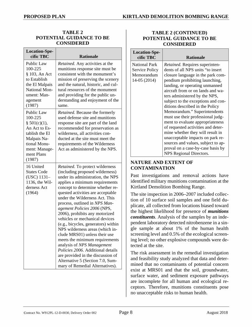
When ARARs do not exist for a remedial activity, other criteria, advisories, and guidance to be con-sidered (TBC) are useful in designing and select-ing a remedial alternative. Four location-specific TBCs were identified (Table 2).
PROPOSED PLAN KIRTLAND DEMOLITION BOMBING RANGE
Contract No. W912PL-12-D-0030, Delivery Order 002 Page 8 August 2018
TABLE 2 POTENTIAL GUIDANCE TO BE
CONSIDERED Location-Spe-
cific TBC Rationale Public Law 100-225 § 103, An Act to Establish the El Malpais National Mon-ument: Man-agement (1987)
Retained. Any activities at the munitions response site must be consistent with the monument’s mission of preserving the scenery and the natural, historic, and cul-tural resources of the monument and providing for the public un-derstanding and enjoyment of the same.
Public Law 100-225 § 501(c)(1), An Act to Es-tablish the El Malpais Na-tional Monu-ment: Manage-ment Plans (1987)
Retained. Because the formerly used defense site and munitions response site are part of the land recommended for preservation as wilderness, all activities con-ducted at the site must meet the requirements of the Wilderness Act as administered by the NPS.
16 United States Code (USC) 1131–1136, the Wil-derness Act (1964)
Retained. To protect wilderness (including proposed wilderness) under its administration, the NPS applies a minimum requirements concept to determine whether re-quested activities are acceptable under the Wilderness Act. This process, outlined in NPS Man-agement Policies 2006 (NPS, 2006), prohibits any motorized vehicles or mechanical devices (e.g., bicycles, generators) within NPS wilderness areas (which in-clude MRS01) unless their use meets the minimum requirements analysis of NPS Management Policies 2006. Additional details are provided in the discussion of Alternative 5 (Section 7.0, Sum-mary of Remedial Alternatives).
TABLE 2 (CONTINUED) POTENTIAL GUIDANCE TO BE
CONSIDERED Location-Spe-
cific TBC Rationale National Park Service Policy Memorandum 14-05 (2014)
Retained. Requires superinten-dents of all NPS units “to insert closure language in the park com-pendium prohibiting launching, landing, or operating unmanned aircraft from or on lands and wa-ters administered by the NPS, subject to the exceptions and con-ditions described in the Policy Memorandum.” Superintendents must use their professional judg-ment to evaluate appropriateness of requested activities and deter-mine whether they will result in unacceptable impacts on park re-sources and values, subject to ap-proval on a case-by-case basis by NPS Regional Directors.
NATURE AND EXTENT OF CONTAMINATION Past investigations and removal actions have identified military munitions contamination at the Kirtland Demolition Bombing Range. The site inspection in 2006–2007 included collec-tion of 10 surface soil samples and one field du-plicate, all collected from locations biased toward the highest likelihood for presence of munitions constituents. Analysis of the samples by an inde-pendent laboratory detected nitrobenzene in a sin-gle sample at about 1% of the human health screening level and 0.5% of the ecological screen-ing level; no other explosive compounds were de-tected at the site. The risk assessment in the remedial investigation and feasibility study analyzed that data and deter-mined that no contaminants of potential concern exist at MRS01 and that the soil, groundwater, surface water, and sediment exposure pathways are incomplete for all human and ecological re-ceptors. Therefore, munitions constituents pose no unacceptable risks to human health.

PROPOSED PLAN KIRTLAND DEMOLITION BOMBING RANGE
Contract No. W912PL-12-D-0030, Delivery Order 002 Page 9 August 2018
The following conclusions were drawn regarding the extent of munitions and munitions constitu-ents contamination at the Kirtland Demolition Bombing Range, based on the results of the 2016 remedial investigation and feasibility study and previous investigations and removals: MRS01: High Explosive Bombing Range • Military munitions contamination has been
confirmed at MRS01. ○ Unexploded general purpose bombs and
fuzes have been found on the surface and in cracks/crevices of the subsurface.
• Unacceptable risks to human receptors are not expected from exposure to munitions constituents.
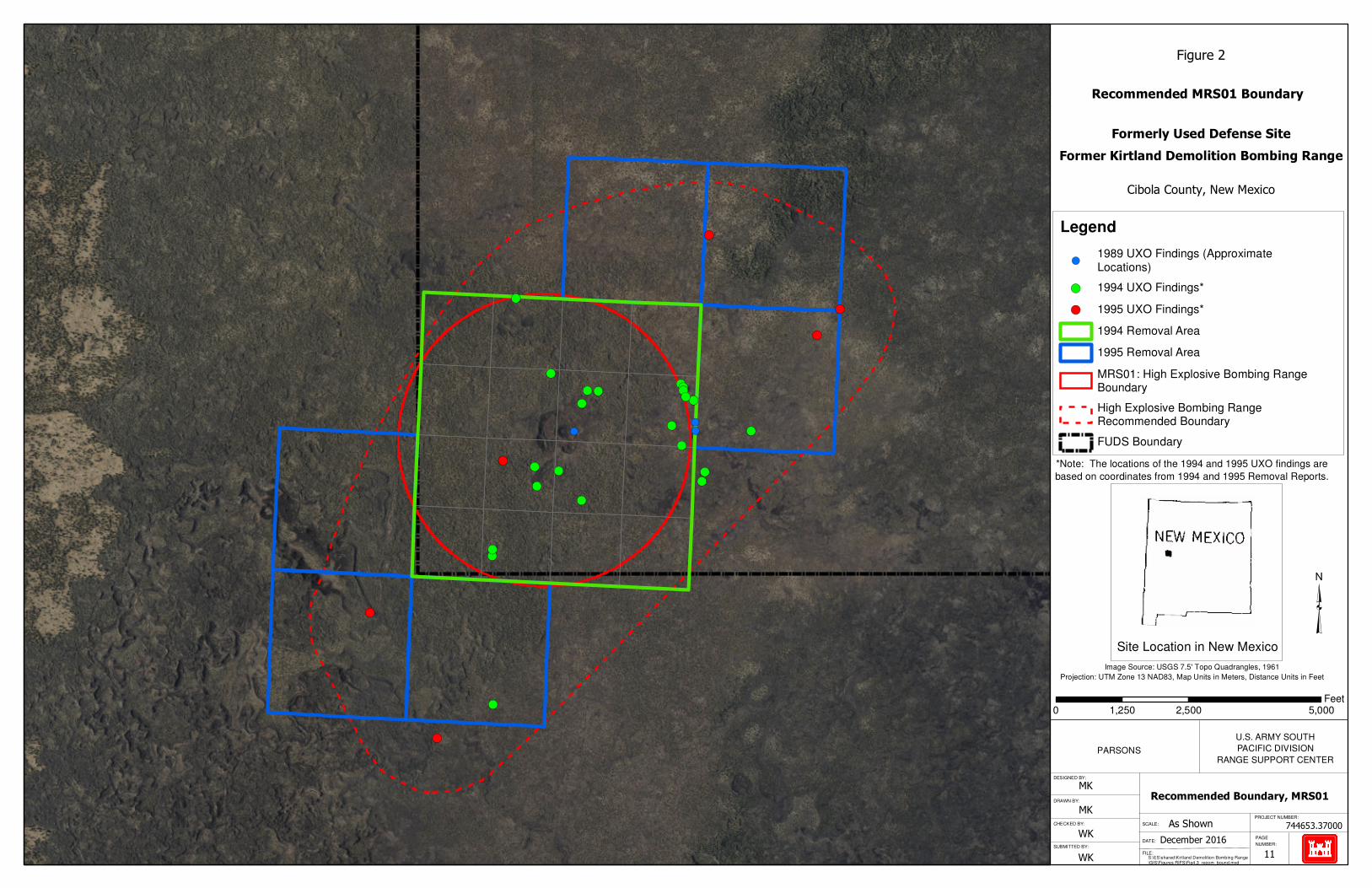
Because MRS01 was a bombing range, it was specified as a 649-acre circle, as shown on Figure 1. However, the 1994 and 1995 removal actions found unexploded ordnance outside MRS01 along the presumed training flight path (Figure 2), so the potential exists for finding additional mu-nitions outside the site, a conclusion supported by observations of munitions debris outside MRS01 during the 2006-2007 site inspection qualitative reconnaissance and the 2015 site reconnaissance. Therefore, the size and shape of the munitions re-sponse site has been recommended for revision to encompass the unexploded ordnance found dur-ing removal actions and investigations in and near MRS01. The USACE, BSEn, and Parsons recom-mended that the munitions response site be ex-panded to 1,694 acres, in a roughly elliptical shape. Figure 2 shows the recommended bound-ary.
4.0 SCOPE AND ROLE OF RESPONSE ACTION
The overall remedial strategy for the project site is to manage risk and protect the public from re-sidual munitions hazards. This strategy will in-volve implementing remedial activities to reduce exposure to explosive hazards for visitors and other site users from potential contact with mili-tary munitions.
5.0 SUMMARY OF SITE RISKS The results of the remedial investigation con-cluded that munitions contamination was present on the surface and subsurface at MRS01. This area was historically documented as an impact area, as confirmed during previous investigations and removals. Reports from removal actions in 1994 and 1995 concluded that the jagged terrain made it unlikely that a complete recovery effort could be achieved and recommended that future visitors to the McCarthy’s Crater area be advised of the potential danger. The most probable muni-tions remaining at the site are the A/N M30 100-pound, general purpose bomb, with associated A/N M103 series nose fuze and M106 tail fuze. Table 3 shows the level of risk at the site.
TABLE 3 SUMMARY OF SITE RISKS
Location Hazard Level Comments
MRS01 High Explo-sive Bombing Range
Moderate po-tential explo-sive hazard conditions
Military munitions found in previous investigations and removals.
6.0 REMEDIAL ACTION OBJECTIVES
To manage risk and protect the public from poten-tial surface and subsurface military munitions, it is necessary to establish remedial action objec-tives for the munitions response site. The remedial action objectives address the goals for reducing the explosives safety hazards to ensure protection of human health and safety. Table 4 summarizes the key information for the remedial action objec-tive developed for MRS01.
TABLE 4 REMEDIAL ACTION OBJECTIVES
Location Remedial Action Objective
MRS01 – High Explo-sive Bomb-ing Range
Reduce exposure to explosive haz-ards for visitors and other site users due to potential contact with mili-tary munitions, with the goal of achieving zero injuries.

PROPOSED PLAN KIRTLAND DEMOLITION BOMBING RANGE
Contract No. W912PL-12-D-0030, Delivery Order 002 Page 10 August 2018
This page intentionally left blank.
!(
!(
!(
!(!(!(
!(!(!(!(!(
!(!(
!(
!(
!(
!(!(!(
!(
!(
!(
!(
!(
!(
!(
!(!(
!(
PARSONS
PROJECT NUMBER:
PAGE
NUMBER:
DESIGNED BY:
DRAWN BY:
CHECKED BY:
SUBMITTED BY:
SCALE:
DATE:
FILE:
Figure 2
S:\ES\shared\Kirtland Demolition Bombing Range\GIS\Figures RIFS\Fig4.3_recom_bound.mxd
744653.37000
December 2016
MK
MK
WK
WK
As Shown
Image Source: USGS 7.5' Topo Quadrangles, 1961
Projection: UTM Zone 13 NAD83, Map Units in Meters, Distance Units in Feet
U.S. ARMY SOUTH
PACIFIC DIVISION
RANGE SUPPORT CENTER
Site Location in New Mexico
Recommended MRS01 Boundary
Recommended Boundary, MRS01
Former Kirtland Demolition Bombing Range
Formerly Used Defense Site
Cibola County, New Mexico
Legend
!(1989 UXO Findings (ApproximateLocations)
!( 1994 UXO Findings*
!( 1995 UXO Findings*
1994 Removal Area
1995 Removal Area
MRS01: High Explosive Bombing RangeBoundary
High Explosive Bombing RangeRecommended Boundary
FUDS Boundary
³
0 2,500 5,0001,250Feet
*Note: The locations of the 1994 and 1995 UXO findings are
based on coordinates from 1994 and 1995 Removal Reports.
!(!(!(
11
PROPOSED PLAN KIRTLAND DEMOLITION BOMBING RANGE
Contract No. W912PL-12-D-0030, Delivery Order 002 Page 12 August 2018
This page intentionally left blank.

PROPOSED PLAN KIRTLAND DEMOLITION BOMBING RANGE
Contract No. W912PL-12-D-0030, Delivery Order 002 Page 13 August 2018
7.0 SUMMARY OF REMEDIAL ALTERNATIVES
This section describes the range of potential op-tions developed and evaluated to achieve the re-medial action objective for MRS01 as identified in the previous section. These remedial alterna-tives comprise a variety of accepted technologies of differing complexities and costs. The six alter-natives developed for consideration are described below.
ALTERNATIVE 1: NO ACTION ALTERNATIVE The No Action Alternative (also referred to as No Further Action under CERCLA) involves no im-plementation of a remedy to reduce the potential explosive hazards posed by possible human inter-action with military munitions. This alternative is evaluated as a baseline alterna-tive for risk determination and for comparison to the action alternatives, including the preferred al-ternative. This alternative does not address re-moval of munitions, so it is not a candidate for un-limited use and unrestricted exposure; therefore, five-year reviews would be required to verify whether the remedy is still working.
ALTERNATIVE 2: EDUCATIONAL AWARENESS Alternative 2 would involve the installation of signs and the development and distribution of fact sheets or brochures, an information kiosk, and a public outreach campaign. An educational aware-ness program would focus on making known those areas containing munitions hazards and providing information regarding the appropriate response if munitions are encountered. The educational awareness program would de-velop educational fact sheets aimed at influencing behavior to reduce the risk of exposure. The fact sheets would be distributed to site visitors, aca-demic researchers, park personnel, and emer-gency responders to educate them about historic military use of the property, the hazards, and proper response if a suspect item is found. Park rangers and resource personnel, emergency
responders, and wildland firefighters would re-ceive special training in munitions hazards and re-sponse. Alternative 2 would also install warning signs and map boards at parking areas and entrances to rec-reational trails. These signs would alert visitors to the potential presence of residual military muni-tions within the area and would reinforce the link between appropriate access and safety measures. An anticipated 20 signs would be installed by USACE. The periodic inspection and mainte-nance (or replacement) of the signs would be the responsibility of the NPS. This alternative does not address removal of mu-nitions, so it is not a candidate for unlimited use and unrestricted exposure; therefore, five-year re-views would be required to verify whether the remedy is still working.
ALTERNATIVE 3: ACCESS CONTROL WITH EDUCATIONAL AWARENESS Alternative 3 would prohibit public use of the rec-ommended munitions response site for greater protectiveness of human health and safety. In ad-dition, educational awareness, as described in Al-ternative 2, would be invoked. “No trespassing” signs would bar entry at the site perimeter, indicating the hazards that exist and that entry beyond that point is not allowed. These signs would be in addition to the hazard warning signs posted at parking areas and access points noting the hazards. Allowable exceptions to pro-hibited use would be for park rangers and resource personnel, emergency responders, and wildland firefighters, all of whom would receive special training in munitions hazards and response. Spe-cial use permits may be granted to academic re-searchers and to tribal members who wish to visit ancestral lands. No policing of the prohibited area is proposed beyond routine land management by the NPS. This alternative does not address removal of mu-nitions, so it is not a candidate for unlimited use and unrestricted exposure; therefore, five-year re-views would be required to verify whether the remedy is still working.

PROPOSED PLAN KIRTLAND DEMOLITION BOMBING RANGE
Contract No. W912PL-12-D-0030, Delivery Order 002 Page 14 August 2018
ALTERNATIVE 4: ENGINEERED CONTROLS WITH EDUCATIONAL AWARENESS Alternative 4 would be nearly identical to Alter-native 3 with the addition of a complete fence sur-rounding the recommended site perimeter (or a partial fence around entrance points) to prevent entry by the public. Warning signs on the fence would inform the public of the munitions hazard and that entry to the land is prohibited. No policing of the prohibited area is proposed due to the remote location and difficult access to the munitions response site. Allowable exceptions to prohibited use would be for park rangers and re-source personnel, emergency responders, and wildland firefighters, all of whom would receive special training in munitions hazards and re-sponse. Special use permits may be granted to ac-ademic researchers and to tribal members who wish to visit ancestral lands. Locked gate en-trances would provide entry for official or permit-ted use. Because Alternative 4 does not include removal of munitions, it would involve installing warning signs on or near the fence/gates and implementing an educational awareness program as described for Alternative 2. This alternative does not address removal of mu-nitions, so it is not a candidate for unlimited use and unrestricted exposure; therefore, five-year re-views would be required to verify whether the remedy is still working.
ALTERNATIVE 5: VISUAL SURFACE INSPECTION AND MUNITIONS AND EXPLOSIVES OF CONCERN REMOVAL WITH EDUCATIONAL AWARENESS Alternative 5 would consist of a surface inspec-tion and removal of residual munitions. Due to the jagged and craggy nature of the lava flow, some surface munitions may have been overlooked if not in the direct line of sight or directly below the explosive ordnance disposal technicians during the 1994 and 1995 removal actions (and 1986 and 1989 emergency removals). Therefore, this alter-native considers performing another surface
inspection and removal. It would also install warning signs and implement an educational awareness program as described for Alternative 2. This alternative would create a higher level of protectiveness of human health, but it is not ex-pected to leave the site free of unexploded ord-nance due to the nearly impossible task of clearing the extreme terrain. Drone- and helicopter-borne instrument surveys were considered, but the trees and terrain at the site prevent flying the low passes needed by air-borne detectors, and the high iron content typical of volcanic rock can make metal detection ex-tremely difficult if not impossible. Limited photo-graphic surveys by drone of just McCartys Crater and a few sampling corridors across the 1-mile-diameter munitions response site would produce thousands of high-resolution infrared and visible-light photographs that at best could show intact bombs but not detached live fuzes; these images would require extremely labor-intensive visual analysis to detect intact bombs because current and anticipated software cannot successfully ana-lyze the data for munitions. Furthermore, drone operations would involve complex logistics, including helicopters to transport crew members and support equipment. Drone crews would be exposed to the same slip, trip, and fall hazard that contributed to multiple sprains, strains, abrasions, and lacerations during prior actions (especially when field personnel are using or carrying instruments and tools). The slip, trip, and fall hazard led the USACE Ordnance and Explosives Safety Specialist in 2015 to require data collection crews or explosive ordnance dis-posal teams at the site to move hands-free to mit-igate the site’s slip, trip, and fall hazard. If technological advances eventually enable effec-tive drone surveillance for munitions, such opera-tions would require a minimum requirements analysis compliant with NPS Management Poli-cies 2006, which applies a two-step process to de-termine “(1) whether the proposed management action is appropriate or necessary for administra-tion of the area as wilderness and does not cause a significant impact to wilderness resources and

PROPOSED PLAN KIRTLAND DEMOLITION BOMBING RANGE
Contract No. W912PL-12-D-0030, Delivery Order 002 Page 15 August 2018
character, in accordance with the Wilderness Act; and (2) the techniques and types of equipment needed to ensure that impacts on wilderness re-sources and character are minimized.” The mini-mum requirements concept further requires that “Administrative use of motorized equipment or mechanical transport will be authorized only if determined by the superintendent to be the mini-mum requirement needed by management to achieve the purposes of the area, including the preservation of wilderness character and values, in accordance with the Wilderness Act; or in emergency situations (for example, search and rescue, homeland security, law enforcement) in-volving the health or safety of persons actually within the area.” NPS Management Policies 2006 cites bicycles as an example of mechanical transport (NPS, 2006). Drone operations would also require an exception to the nationwide ban on drone use in NPS units (NPS, 2014). Because airborne surveys are not yet feasible, Al-ternative 5 would use on-the-ground surface in-spection, which would require a substantial allo-cation of manpower and resources. The 1994 re-moval action used 33 trained explosive ordnance disposal technicians and four support personnel for 15 days, with nine or 10 flights daily to shuttle personnel to and from the site. The 1995 clearance used 43 explosive ordnance disposal personnel and seven support personnel for 15 days, with hel-icopter shuttles to and from the site taking 80 minutes each day. Extrapolating to cover about two-thirds of the recommended site boundary would require 40 persons for two months, includ-ing seven helicopter trips each day to shuttle per-sonnel and equipment to and from the site. This alternative does not address removal of mu-nitions, so it is not a candidate for unlimited use and unrestricted exposure; therefore, five-year re-views would be required to verify whether the remedy is still working.
ALTERNATIVE 6: VISUAL SURFACE INSPECTION AND DIGITAL GEOPHYSICAL MAPPING WITH SURFACE AND SUBSURFACE REMOVAL Alternative 6 is evaluated as the best effort to the-oretically achieve unlimited use and unrestricted exposure at MRS01. This alternative would in-clude both visual surface inspection with muni-tions removal and geophysical investigation with munitions removal. Logistics for a visual surface inspection and munitions removal would be the same as described in Alternative 5. In addition, a geophysical investigation would be required. However, current deployment techniques for geo-physical instruments are not ideal for McCartys Crater: • Cart-mounted instruments will not work due
to extremely rugged, unnavigable terrain. • Handheld instruments will work to a point,
but data collection is very slow, and they have been prohibited by the USACE Explo-sives Safety Specialist due to operator safety issues and the need to work hands-free to re-duce the slip, trip, and fall hazard.
• Airborne sensing is not feasible for the rea-sons discussed in Alternative 5.
Therefore, complex logistical solutions must be considered, such as helicopter shuttle for person-nel, equipment, and supplies, or camping on site.
8.0 ALTERNATIVES EVALUATION
The rationale for selecting the preferred alterna-tive was based on nine criteria used to compare the six potential alternatives to one another in a detailed analysis. The nine criteria fall into three groups: threshold criteria, primary balancing cri-teria, and modifying criteria: • Threshold criteria are requirements an alter-
native must meet to be eligible for selection. • Primary balancing criteria weigh major
tradeoffs among alternatives. • Modifying criteria may be considered to the
extent that information is available during the feasibility study, but they can be fully

PROPOSED PLAN KIRTLAND DEMOLITION BOMBING RANGE
Contract No. W912PL-12-D-0030, Delivery Order 002 Page 16 August 2018
considered only after public comment is re-ceived on the Proposed Plan. In the final bal-ancing of tradeoffs between alternatives upon which the final remedy selection is based, modifying criteria are of equal importance to the balancing criteria.
Table 5 summarizes the evaluation criteria. The Remedial Investigation and Feasibility Study Re-port (BSEn and Parsons, 2018) describes both the individual analyses and the comparative analyses of the remedial alternatives for MRS01. These analyses are described below for each remedial al-ternative, and Table 6, at the end of Section 8, compares each alternative across the threshold factors and balancing factors.
ALTERNATIVE 1: NO ACTION ALTERNATIVE Alternative 1 would not manage potential risks to human health; therefore, it would not provide overall protectiveness of human health and the en-vironment. It also would not achieve the remedial action objective for MRS01, so it fails to meet ei-ther threshold criterion and is therefore not imple-mentable as a remedy. Although this alternative does not meet the screening requirements, it was retained for further evaluation for comparative purposes.
ALTERNATIVE 2: EDUCATIONAL AWARENESS Alternative 2 would manage potential risks to hu-man health by keeping the public aware of the
munitions hazards. Implementation of this alter-native would provide long-term effectiveness through maintenance of the installed signs and regular production/distribution of educational ma-terials such as informational pamphlets. Although there would be no reduction of the toxicity, mo-bility, or volume of potential munitions through removal (the preferred approach under CERCLA for reducing the potential risks to human health from contaminants, including munitions), human exposure risk would be decreased through im-proved public awareness, despite the unchanged hazard level and score. Therefore, Alternative 2 would achieve the remedial action objective of re-ducing exposure to explosive hazards for visitors and other site users due to potential contact with military munitions, with the goal of achieving zero injuries. Workers would be exposed to short-term munitions hazards while installing and main-taining signs, but these hazards would be man-aged with industry standard safety procedures (e.g., using qualified unexploded ordnance per-sonnel, practicing anomaly avoidance). This al-ternative could readily be implemented. The rem-edy would not be cost prohibitive. Based on the attainability of the effectiveness, implementabil-ity, and cost screening requirements, Alterna-tive 2 was retained for further evaluation.

PROPOSED PLAN KIRTLAND DEMOLITION BOMBING RANGE
Contract No. W912PL-12-D-0030, Delivery Order 002 Page 17 August 2018
TABLE 5 EVALUATION CRITERIA FOR SUPERFUND REMEDIAL ALTERNATIVES
Cri
teri
a
Thr
esho
ld
Overall protectiveness of human health and the environment determines whether an alter-native eliminates, reduces, or controls threats to public health and the environment through in-stitutional controls, engineering controls, or treatment. Compliance with applicable or relevant and appropriate requirements evaluates whether the alternative complies with substantive provisions of any promulgated federal or more strin-gent state environmental standards, requirements, criteria, or limitations that are determined to be legally applicable or relevant and appropriate requirements for a CERCLA site.
Prim
ary
Bal
anci
ng
Long-term effectiveness and permanence considers the ability of an alternative to maintain protection of human health and the environment over time. Reduction of toxicity, mobility, or volume of contaminants through treatment evaluates an alternative’s use of treatment to reduce the harmful effects of principal contaminants, their abil-ity to move in the environment, and the amount of contamination present. Short-term effectiveness considers the length of time needed to implement an alternative and the risks the alternative poses to workers, residents, and the environment during implementa-tion. Implementability considers the technical and administrative feasibility of implementing the alternative, including factors such as the relative availability of goods and services. Cost includes estimated capital and annual operations and maintenance costs, as well as present worth cost. Present worth cost is the total cost of an alternative over time in terms of today’s dollar value. Cost estimates are expected to be accurate within a range of +50% to -30%.
Mod
ifyin
g
State/support agency acceptance considers whether the state agrees with the analyses and rec-ommendations, as described in the Remedial Investigation and Feasibility Study Report and Proposed Plan. Community acceptance considers whether the local community agrees with the analyses and preferred alternative. Comments received on the Proposed Plan are an important indicator of community acceptance.

PROPOSED PLAN KIRTLAND DEMOLITION BOMBING RANGE
Contract No. W912PL-12-D-0030, Delivery Order 002 Page 18 August 2018
ALTERNATIVE 3: ACCESS CONTROL WITH EDUCATIONAL AWARENESS Alternative 3 would manage potential risks to hu-man health by closing the munitions response site to the public to reduce or eliminate human expo-sure to munitions hazards. Because no fence is proposed under this alternative, the possibility of the public entering the site exists (either in error or by ignoring signs); however, the three-hour hike in unforgiving terrain constitutes a natural barrier to entry. No trespassing signs and warning signs would alert the public to munitions hazards. Implementation of this alternative would provide long-term effectiveness through maintenance of the installed signs and by regular production and distribution of educational materials. Although the hazard level and score would remain the same and there would be no reduction of the toxicity, mobility, or volume of potential munitions through removal, human exposure risk would be decreased. By reducing the potential for the public to encounter military munitions and knowing avoidance and reporting procedures if encoun-tered, Alternative 3 would achieve the remedial action objective. This alternative could readily be implemented if an agreement to close the area is reached between the NPS and the stakeholders. However, closing the area would be inconsistent with the legislated obligation of the NPS to pro-vide for the enjoyment of scenery and of natural and historic objects within its parks, monuments, and reservations (16 USC l–4, referred to as the Organic Act). The remedy would not be cost pro-hibitive. Based on the attainability of the effec-tiveness, implementability, and cost screening re-quirements, Alternative 3 was retained for further evaluation.
ALTERNATIVE 4: ENGINEERED CONTROLS WITH EDUCATIONAL AWARENESS Alternative 4 would manage potential risks to hu-man health by fencing the entire boundary or stra-tegic sections of the site boundary to bar entry and use by the public in order to reduce or eliminate human exposure to munitions hazards. This alter-native would deny entry to the site by the public
except for official or permitted use, or by deter-mined trespassers who may scale or bypass the fence. “No trespassing” signs and hazard warning signs would alert the public to munitions hazards. Implementation of this alternative would provide long-term effectiveness through maintenance of the fence and installed signs and by regular pro-duction and distribution of educational materials. Human exposure risk would be decreased, but there would be no reduction of the toxicity, mo-bility, or volume of potential munitions through removal. Although this alternative could be im-plemented if an agreement to close the area is reached between the NPS and the stakeholders, the logistics of building a fence around the site are daunting due to the remote location and treacher-ous terrain. Also, the undulating terrain with cracks and crevices would make it relatively easy to duck under the fence. This remedy would not necessarily be cost prohibitive. Based on the mar-ginal effectiveness and poor implementability of fencing the entire site boundary or strategic sec-tions of this remote, broken topography, Alterna-tive 4 was not retained for further evaluation.
ALTERNATIVE 5: VISUAL SURFACE INSPECTION AND MUNITIONS AND EXPLOSIVES OF CONCERN REMOVAL WITH EDUCATIONAL AWARENESS Alternative 5 would manage potential risks to hu-man health by identifying and removing military munitions on the surface and by ensuring that the public is aware of munitions hazards through ed-ucation awareness. Therefore, this alternative meets the long-term effectiveness criterion for re-sidual surface munitions within the munitions re-sponse site. Some munitions hidden in cracks and crevices would be missed and the subsurface would not be cleared, but this alternative would achieve partial reduction in the toxicity, mobility, or volume of surface military munitions. Alterna-tive 5 would not change the hazard level but would decrease (improve) the hazard score and so would achieve the remedial action objective es-tablished for MRS01. The hazards associated with increased munitions exposure for workers in-volved with the surface munitions removal would

PROPOSED PLAN KIRTLAND DEMOLITION BOMBING RANGE
Contract No. W912PL-12-D-0030, Delivery Order 002 Page 19 August 2018
be managed with industry standard safety proce-dures (e.g., using qualified unexploded ordnance personnel, practicing anomaly avoidance). The slip, trip, and fall safety hazard associated with the treacherous terrain would not be managed under this alternative. The estimated cost is based on the human and other resources used in the 1994 and 1995 removal actions and on costs associated with similar activities at other Military Munitions Re-sponse Program sites. The remedy would be ex-pensive (primarily due to use of helicopters to de-liver personnel and equipment) but not neces-sarily cost prohibitive; and helicopter use would require a minimum requirements analysis due to NPS regulations to meet Wilderness Act require-ments. Implementation of this alternative would provide long-term effectiveness through mainte-nance of the installed signs and regular produc-tion/distribution of educational materials. Based on its overall effectiveness and implementability, Alternative 5 was retained for further evaluation.
ALTERNATIVE 6: VISUAL SURFACE INSPECTION AND DIGITAL GEOPHYSICAL MAPPING WITH SURFACE AND SUBSURFACE REMOVAL Alternative 6 would manage potential risks to hu-man health through source area reduction; there-fore, it could theoretically meet the long-term ef-fectiveness criterion for residual subsurface mu-nitions within the site. However, although surface inspection and removal could be effective, current geophysical techniques would provide only lim-ited effectiveness on the lava field due to deep crevices, collapsed lava bubbles, and lava tubes. This alternative would be difficult if not impossi-ble to implement. Standard cart-mounted geo-physical instrument will not work due to uneven surfaces, sharp drops, and crevices. Hand-held in-struments were considered, but a field test of
the MineLab F3 showed that data collection was very slow. Moreover, because the site’s craggy and treacherous terrain creates a severe injury risk for field technicians, the USACE Explosives Safety Specialist determined that field personnel must keep their hands free during field work to mitigate the slip, trip, and fall hazard in the lava field. This requirement prevents the use of instru-ments and tools for collecting the necessary geo-physical transects and soil samples. Extensive use of helicopters to deliver numerous personnel and the additional equipment needed for digital geo-physical mapping would greatly increase costs and would require a minimum requirements anal-ysis due to NPS regulations to meet Wilderness Act requirements. The three-hour hike to the edge of the munitions response site make productivity unacceptably low (and cost unacceptably high) for this alternative. Although this alternative would reduce toxicity, mobility, or volume of munitions through source removal on the surface and subsurface, due to the technical challenges, the potential cost of this al-ternative would be prohibitive. In summary, due to marginal effectiveness, poor implementability, and high cost, Alternative 6 was not retained for further evaluation.

PROPOSED PLAN KIRTLAND DEMOLITION BOMBING RANGE
Contract No. W912PL-12-D-0030, Delivery Order 002 Page 20 August 2018
This page intentionally left blank.

PROPOSED PLAN KIRTLAND DEMOLITION BOMBING RANGE
Contract No. W912PL-12-D-0030, Delivery Order 002 Page 21 August 2017
TABLE 6
EVALUATION OF RESPONSE ALTERNATIVES
Alternative
THRESHOLD FACTORS BALANCING FACTORS
Overall Protection of Human Health and the Environment
Compliance with ARARs(1)
Long-Term Effectiveness and Permanence
MEC HA Haz-ard Level/ Score
Reduction of Toxicity, Mobility, or Volume by
Treatment Short-term Effective-
ness Implementability Total Present
Value(2) 1 No Action No. Not protective of human health and
environment. Included as a baseline for comparison with the remaining alterna-tives.
Not applicable Not effective over long term. 3 / 700 Provides no reduction of source area TMV.
No short-term risks be-cause no actions re-quired.
Highly implementable because no actions required. $0
2 Educational Aware-ness
Yes. Risk reduced by providing infor-mation to landowner and public. Fact sheet and warning signs will provide hazard recognition to reduce chance of exposure.
Not applicable No reduction in possible MEC, but can be effective at influencing behavior and en-couraging appropriate re-sponses.
3 / 700 Provides no reduction of source area TMV.
Minimal short-term risks because little field actions required.
Highly implementable. Information readily available and easily developed. Currently partially implemented.
$457,581 Reasonable
3 Access Control with Educational Aware-ness
Yes. Risk reduced by prohibiting public entry onto MRS01 using perimeter signs. Fact sheet and warning signs will provide hazard recognition to reduce chance of exposure.
Not applicable No reduction in possible MEC, but will be somewhat effective in limiting exposure and risk.
3 / 700 Provides no reduction of source area TMV.
Minimal short-term risks because little field actions required.
Readily implemented. $943,536 Reasonable
5 Visual Surface In-spection and MEC Removal with Educa-tional Awareness
Yes. Source area reduction achieved via surface MEC clearance. Further miti-gate residual MEC hazards by reducing potential for exposure via awareness and education.
Not applicable Provides some level of long-term effectiveness. However, residual MEC are highly prob-able (given terrain and limita-tions in technology/equip-ment).
3 / 545 Provides source area re-duction of TMV in MEC-contaminated areas.
Possible short-term im-pacts associated with MEC removal and probable risk due to hazardous terrain.
Not readily implementable due to hazardous terrain and resultant restrictions for safety. Clearance requires quali-fied UXO technicians using specific equipment according to work plans, but to reduce slip, trip, and fall risks, the Army OESS has prohibited the use of hand-held equip-ment in the treacherous terrain. Airborne sensing is not feasible because the trees and terrain at the site would prevent passes at a sufficiently low altitude for effective use of drone- or helicopter-borne instruments, and the high iron content typical of volcanic rock can make metal detection extremely difficult if not impossible. Limiting photographic data obtained by drone to just McCartys crater and a few sampling passes across the 1-mile-diam-eter munitions response site would produce thousands of high-resolution infrared and visible-light images that are capable of showing objects the size of intact bombs but still incapable of showing objects as small as detached live fuzes; these images would require extremely labor-intensive visual analysis to detect intact bombs because current and anticipated software cannot successfully ana-lyze the data for MEC. If MEC were to be identified, ex-plosive ordnance disposal teams removing it or rendering it safe would be faced with the same conditions that led the OESS to require field teams to work hands-free to mitigate the site’s slip, trip, and fall hazard.
$6,594,215 Expensive
ARAR = applicable or relevant and appropriate requirement; MEC = munitions and explosives of concern; MEC HA = munitions and explosives of concern hazard assessment; MRS01 = Munitions Response Site 01– High Explosive Bombing Range; NA = not applicable; NPS = National Park Service; OESS = ordnance and explosives safety specialist; TMV = toxicity, mobility, or volume; UXO = unexploded ordnance MEC HA hazard level and score are provided for each alternative. (1) No ARARs were identified; therefore, an assessment of “compliance with ARARs” cannot be conducted. (2) Total present value is discussed in the Remedial Investigation and Feasibility Study Report in Chapter 10, Detailed Analysis of Alternatives.

PROPOSED PLAN KIRTLAND DEMOLITION BOMBING RANGE
Contract No. W912PL-12-D-0030, Delivery Order 002 Page 22 August 2017
This page intentionally left blank.

PROPOSED PLAN KIRTLAND DEMOLITION BOMBING RANGE
Contract No. W912PL-12-D-0030, Delivery Order 002 Page 23 August 2018
9.0 PREFERRED ALTERNATIVE This section describes the preferred alternative and explains how it is expected to fulfill statutory and regulatory requirements. The four alternatives retained for further evaluation were evaluated in terms of the two threshold criteria and the five pri-mary balancing criteria, as well as the munitions hazard analysis results. • Alternative 1: No Action Alternative • Alternative 2: Educational Awareness • Alternative 3: Access Control with Educa-
tional Awareness • Alternative 5: Visual Surface Inspection and
Munitions and Explosives of Concern Re-moval with Educational Awareness
The preferred alternative for MRS01 is Alterna-tive 2, Educational Awareness. This alternative provides an acceptable level of military munitions hazard management while remaining cost effec-tive. It also allows El Malpais National Monu-ment visitors to continue to enjoy and understand the park’s natural, historic, and cultural resources, which is the purpose of NPS parks, monuments, and reservations according to the agency’s found-ing legislation (16 USC l–4, referred to as the Or-ganic Act of 1916).
THRESHOLD CRITERIA Alternatives 2, 3, and 5 protect human health and the environment; Alternative 1, which fails to pro-vide such protection, was included for compari-son only. Because no ARARs were identified, no compari-son for ARAR compliance is possible.
PRIMARY BALANCING CRITERIA Alternative 1 would not reduce munitions haz-ards. Alternative 2 would achieve long-term ef-fectiveness and permanence by maintaining in-stalled signs and by regularly producing and dis-tributing educational materials to reduce the risk of exposure to military munitions. In addition to these actions, Alternative 3 would prohibit public use of MRS01 for a slight additional reduction, and Alternative 5 would use surface removal of
munitions in the munitions response site to further reduce the risk of exposure to munitions (reflected in a reduced hazard assessment score, although the score reduction would not be enough to reduce the hazard level). Alternatives 1, 2, and 3 offer no reduction in tox-icity, mobility, or volume of munitions. Alterna-tive 5 achieves partial reduction because it in-volves removal of surface military munitions. None of these alternatives would completely re-move all munitions at the site. Alternative 1 has the highest short-term effective-ness because it does not involve munitions opera-tions or other hazardous activities. Alternatives 2 and 3 would result in short-term hazards to work-ers involved with the installation of signs because of the increased likelihood of munitions exposure. However, these hazards would be managed using industry standard safety procedures (e.g., using qualified unexploded ordnance personnel, prac-ticing anomaly avoidance). Alternative 5 would have the greatest risk and least short-term effec-tiveness due to the increased likelihood of muni-tions detonation during removal operations; there-fore, trained technicians would perform the work. Alternatives 1 and 2 were determined to be best for implementability. Alternative 1 requires no services or materials. Alternatives 2 and 3 involve fact sheets and warning signs, which are readily available; however, Alternative 3 could be imple-mented only if the NPS and stakeholders agree to close the area to the public, which would be in-consistent with the legal obligation of the NPS to provide for the enjoyment of scenery and of natu-ral and historic objects within El Malpais National Monument. Alternative 5 would require expert unexploded ordnance technicians working in haz-ardous terrain with a high probability of injury (e.g., sprains, strains, abrasions, and lacerations); this work would require development of a detailed work plan. The financial cost to implement the alternatives includes direct, indirect, and long-term operations and maintenance costs. These estimated costs are based on actual costs of similar activities and cost estimates prepared for other Military Munitions
PROPOSED PLAN KIRTLAND DEMOLITION BOMBING RANGE
Contract No. W912PL-12-D-0030, Delivery Order 002 Page 24 August 2018
Response Program sites; the cost for Alternative 5 also considers the manpower used for the 1994 and 1995 removal actions adjusted for the relative size of the recommended munitions response site boundary. Alternative 2 is roughly $460,000 more expensive in total present value than Alternative 1, No Action; Alternative 3 is about twice as ex-pensive as Alternative 2, at around $944,000; and Alternative 5 is roughly seven times as expensive as Alternative 3, at approximately $6,594,000. The preferred alternative would not address mu-nitions that may have wedged in the subsurface or fallen into crevices, so like Alternatives 1, 3, and 5, it is not a candidate for unlimited use and unre-stricted exposure; therefore, five-year reviews would be required to verify whether the remedy is still working. The preferred alternative was selected by as-sessing how well each alternative performs
against the two threshold criteria and the five bal-ancing criteria. Based on information currently available, the USACE believes the Preferred Al-ternative meets the threshold criteria and provides the best balance of tradeoffs among the other al-ternatives with respect to the balancing and mod-ifying criteria. The preferred alternative is based on current information and could change in re-sponse to public comment or new information. The preferred alternative satisfies the following statutory requirements of CERCLA § 121(b): 1) be protective of human health and the environ-ment; 2) comply with ARARs; 3) be cost-effec-tive; 4) use permanent solutions and alternative treatment technologies or resource recovery tech-nologies to the maximum extent practicable; and 5) consider the preference for treatment as a prin-cipal element during alternatives analysis. Table 7 provides a comparative analysis of the alterna-tives.

PROPOSED PLAN KIRTLAND DEMOLITION BOMBING RANGE
Contract No. W912PL-12-D-0030, Delivery Order 002 Page 25 August 2018
TABLE 7
COMPARATIVE ANALYSIS OF ALTERNATIVES
Criterion Alternative 1:
No Action
Alternative 2: Educational Aware-
ness
Alternative 3: Access Control with Educational Aware-
ness
Alternative 5: Visual Surface Inspec-tion and Munitions and Explosives of Concern Removal with Educa-
tional Awareness Threshold Criteria Overall Protection of Human Health and the Environment Fail Pass Pass Pass
Compliance with Applicable or Rele-vant and Appropriate Requirements NA NA NA NA
Balancing Criteria Long-Term Effectiveness and Perma-nence NA
Reduction of Toxicity, Mobility, or Volume through Treatment NA
Short-Term Effectiveness NA Implementability NA Cost NA Modifying Criteria State/Regulatory Agency Acceptance NA Neutral Neutral Accept Community Acceptance NA TBD TBD TBD NA: Not applicable; TBD: to be determined Balancing criteria rankings: Meets criterion Good ability to meet criterion Fair ability to meet criterion Does not meet criterion

PROPOSED PLAN KIRTLAND DEMOLITION BOMBING RANGE
Contract No. W912PL-12-D-0030, Delivery Order 002 Page 26 August 2018
10.0 COMMUNITY PARTICIPATION
The final balancing of tradeoffs between alterna-tives to determine the final remedy will occur af-ter public comment is received on the Proposed Plan. Modifying criteria (state/support agency ac-ceptance and community acceptance) are of equal importance to the balancing criteria. The final Remedial Investigation and Feasibility Study Report was placed in the administrative record in March 2018. It provides a comprehen-sive description of the history of the site, the de-tails of the remedial investigation, the associated risk assessments, and their conclusions. It and other information on the Kirtland Demolition Bombing Range are available for review in the ad-ministrative record, at:
Grants Public Library 1101 N. First St. Grants, NM 87020
The USACE is soliciting public review and com-ment on a proposed plan for remediation of the High Explosive Bombing Range at Kirtland Dem-olition Bombing Range. The public is encouraged to comment, and comments received will be con-sidered before any action is selected and ap-proved. A public meeting will take place on Wednesday September 26, 2018 at the Northwest New Mexico Visitor’s Center from 4:00 p.m. to 7:00 p.m. Representatives from the USACE, NMED, USEPA, and NPS will be present to ex-plain the Proposed Plan, listen to concerns, an-swer questions, and accept public comments. Written comments on this Proposed Plan will be accepted throughout a 30-day public comment pe-riod from September 07, 2018 through October 10, 2018. Please submit written comments to Lu Tan (information below). For further information on the project site, please contact the following representatives.
USACE Representatives Lu Tan, USACE Project Manager USACE, Los Angeles District 915 Wilshire Blvd, Suite 15018 Los Angeles, CA 90017-3401 Phone: 213-452-3669 Email: [email protected] Mark Phaneuf, USACE Design Integrator USACE, Albuquerque District 4101 Jefferson Plaza NE Albuquerque, NM 87109 Phone: 505-342-3295 Email: [email protected]
Regulatory Representatives Greg J. Lyssy, USEPA Senior PM U.S. Environmental Protection Agency 1445 Ross Avenue, Dallas, TX 75202 Phone: 214-665-8317 Email: [email protected] Kristen Van Horn, Environmental Scientist and Specialist New Mexico Environment Department Hazardous Waste Bureau 2905 Rodeo Park Drive East, Building 1 Santa Fe, NM 87505 Phone: 505-476-6046 Email: [email protected]
REFERENCES Air Force Civil Engineer Support Agency, Ex-
plosive Ordnance Support Division. 2010. Report: 23 July 2010 UXO, El Malpais Na-tional Monument, Pick Up and/or Disposal (UXO). AFMKIRT1007282022Z.
Bering Sea Environmental LLC and Parsons Government Services Inc. (BSEn and Par-sons). 2015. Site Reconnaissance Report: Kirtland Demolition Bombing Range, Cibola County, New Mexico. Conducted 22 April 2015. FUDS Project No. K06NM045301. August.
BSEn and Parsons. 2018. Final Remedial Inves-tigation Report and Feasibility Study: Kirtland Demolition Bombing Range, Cibola County, New Mexico. March.

PROPOSED PLAN KIRTLAND DEMOLITION BOMBING RANGE
Contract No. W912PL-12-D-0030, Delivery Order 002 Page 27 August 2018
Bureau of Land Management (BLM). 1987. Let-ter to Mr. Bob Bailey, Department of the Army Explosive Safety Board, requesting surface clearance following 1986 bomb deto-nations by 41st Ordnance Detachment. 29 January.
Defense Environmental Programs. 2006. Annual Report to Congress: Fiscal Year 2005. http:// deparc.egovservices.net/deparc/do/home.
National Park Service (NPS). 1989. Memoran-dum: Detonation of World War Two Ord-nance in the McCartys Crater Area on Sep-tember 12, 1989.
NPS. 2006. Management Policies 2006. ISBN 0-16-076874-8.
NPS. 2014. Policy Memorandum 14-05: Un-manned Aircraft – Interim Policy. https://www.nps.gov/policy /PolMemos/PM_14-05.htm. June 19.
Parsons. 2007. Site Inspection Report: Former Kirtland Demolition Bombing Range, Cibola County, New Mexico. FUDS Project No. K06NM045301. July.
USACE. 1993. Inventory Project Report (INPR) for Kirtland Demolition Bombing Range, Site No. K06NM045300. 5 October.
USACE. 1996. Archives Search Report Findings for the Former Kirtland Demolition Bombing Range. Project No. K06NM045301. Prepared by USACE, Rock Island District. August.
USACE. 2004. ASR Supplement for the Kirtland Demolition Bombing Range, Cibola County, New Mexico. Prepared by USACE Rock Is-land District. 26 November.
USACE, 2014. Comments on TPP Meeting 1 Minutes. Information from Hank Domme, USACE Lead Ordnance and Explosives Safety Specialist.
U.S. Army Engineering Division, Huntsville. 1994. Removal Report for the Kirtland Dem-olition Bombing Range Ordnance Removal Project, El Malpais National Monument, Grants, New Mexico, May 7–21, 1994. Pre-pared by the 669th Ordnance Detachment, Al-abama Army National Guard. 1 July.
U.S. Army Engineering Division, Huntsville. 1995. Removal Report for the Kirtland Dem-olition Bombing Range Ordnance Removal Project, El Malpais National Monument, Grants, New Mexico, 17 June – 2 July 1995. Prepared by the 669th Ordnance Detachment, Alabama Army National Guard. 1 August.
U.S. Environmental Protection Agency (USEPA). 1999. A Guide to Preparing Su-perfund Proposed Plans, Records of Deci-sion, and Other Remedy Selection Decision Documents. EPA 540-R-98-031. July.
GLOSSARY OF TERMS Administrative Record. A compilation of all documents relied upon to select a remedial action pertaining to the investigation and remediation of the project site. Anomaly. A subsurface irregularity identified by a geophysical investigation that represents poten-tial military munitions. Applicable or Relevant and Appropriate Re-quirements (ARARs). Those cleanup standards, standards of control, and other substantive re-quirements, criteria, or limitations promulgated under federal environmental laws, state environ-mental laws, or facility siting laws that specifi-cally address a hazardous substance, pollutant, contaminant, remedial action, location, or other circumstance at a Comprehensive Environmental Response, Compensation, and Liability Act site. Archives Search Report. A report based on a site visit to search for evidence of munitions use and on review of available records, photographs, and reports to document the history of a formerly used defense site. Prepared after the Inventory Project Report, it serves as the source of most historical information pertaining to site operations and iden-tifies the key areas of focus for the ensuing site inspection. Archives Search Report Supplement. A sum-mary of key information from the Archives Search Report, including the range identification number, a brief site description and history, the

PROPOSED PLAN KIRTLAND DEMOLITION BOMBING RANGE
Contract No. W912PL-12-D-0030, Delivery Order 002 Page 28 August 2018
site’s risk assessment code, and a list of munitions used. Comprehensive Environmental Response, Compensation, and Liability Act (CERCLA). A federal law that addresses the discharge and re-mediation of hazardous substances, pollutants, and contaminants into the environment. Provides for a structured remedial system, makes any entity that had a role in the contamination liable for the cleanup, arranges for the funding of abandoned sites, and authorizes the National Oil and Hazard-ous Substances Pollution Contingency Plan. Decision Document. The USACE uses the term “Decision Document” for the final remedial ac-tion decision at formerly used defense site prop-erties. Same as the Record of Decision as listed in the National Oil and Hazardous Substances Pollu-tion Contingency Plan. Feasibility Study. A study that evaluates possible remedies using the information generated from the remedial investigation. The feasibility study becomes the basis for selection of a remedy that effectively eliminates the threat posed by contam-inants at the site. Formerly Used Defense Site. Properties that were owned by, leased to, or otherwise possessed by and under the jurisdiction of the Department of Defense that were transferred to Department of Defense control before 17 October 1986. Inventory Project Report. The document report-ing U.S. Army Corps of Engineers findings about whether a property is eligible as a Formerly Used Defense Site and evaluating the potential issues and concerns at that site. Military Munitions Response Program. Estab-lished in 2001, this program oversees response ac-tions to address munitions and explosives of con-cern as well as munitions constituents at eligible formerly used defense site properties. Munitions Constituents. Any materials originat-ing from unexploded ordnance, discarded military munitions, or other military munitions, including explosive and non-explosive materials, and emis-sion, degradation, or breakdown elements of such ordnance or munitions.
Munitions Debris. A military munition or com-ponents thereof that does not contain explosives or pyrotechnics. Munitions and Explosives of Concern. Specific categories of military munitions that may pose unique explosives safety risks, including (a) un-exploded ordnance, (b) discarded military muni-tions, or (c) explosive munitions constituents (e.g., TNT, RDX) present in high enough concen-trations to pose an explosive hazard. Munitions Response Site. A discrete location within a defense site that is known to require a munitions response (investigation, removal ac-tion, or remedial action). National Oil and Hazardous Substance Pollu-tion Contingency Plan. Revised in 1990, the plan provides the regulatory framework for responses under CERCLA. It designates the Department of Defense as the removal response authority for ordnance and explosives hazards. Preferred Alternative. The alternative that, when compared to other potential alternatives across the threshold criteria and the primary bal-ancing criteria, is determined to best meet the CERCLA evaluation criteria and is proposed for implementation at a site. Project Site. The project site addressed by this Proposed Plan is MRS01, the High Explosive Bombing Range at Kirtland Demolition Bombing Range, which was used during World War II by bomber aircraft dropping live bombs as part of the Army Air Forces bombardier training program. Proposed Plan. A plan that identifies the pre-ferred remedial alternative for a site and is made available to the public for comment. Remedial Investigation (RI). Exploratory in-spection conducted at a site to define the nature and extent of contamination present. Remedial Action Objectives. Cleanup objectives that specify contaminants to be cleaned up, the cleanup standard, the area of cleanup, and the time required to achieve cleanup, for protecting human health and the environment.

PROPOSED PLAN KIRTLAND DEMOLITION BOMBING RANGE
Contract No. W912PL-12-D-0030, Delivery Order 002 Page 29 August 2018
Superfund. A U.S. government program to fund the cleanup of hazardous substances, pollutants, and contaminants. See Comprehensive Environ-mental Response, Compensation, and Liability Act (CERCLA) in this glossary. Total Present Value. The total dollar value in the present day of a sum of money. Unexploded Ordnance. Military munitions that (a) have been primed, fuzed, armed, or otherwise prepared for action; (b) have been fired, dropped, launched, projected, or placed in such a manner as to constitute a hazard to operations, installations, personnel, or material; and (c) remain unexploded either by malfunction, design, or other cause.
ACRONYMS AND ABBREVIATIONS ARAR applicable or relevant and appropriate re-
quirements BLM Bureau of Land Management BSEn Bering Sea Environmental LLC
CERCLA Comprehensive Environmental Response, Compensation, and Liability Act
MRS01 Munitions Response Site 01 NMED New Mexico Environment Department
NPS National Park Service Parsons Parsons Government Services, Inc.
TBC to be considered USACE United States Army Corps of Engineers
USC United States Code USEPA United States Environmental Protection
Agency
Remember to practice the “Three Rs” of un-exploded ordnance safety:
Recognize Know when you may have encountered a munition, and remember that munitions are dangerous.
Retreat Do not approach, touch, move, or disturb the potential munition, but carefully leave the area.
Report Immediately call police or sheriff; report what was found and its location.
For more information, visit http://www.de-nix.osd.mil/portal/page/portal/UXOSafety

PROPOSED PLAN KIRTLAND DEMOLITION BOMBING RANGE
Contract No. W912PL-12-D-0030, Delivery Order 002 Page 30 August 2018
This page intentionally left blank.