process of integrating digital cadastral map and urban ... · water pipelines (onep data), the...
TRANSCRIPT

TS 37 – Spatial Development Infrastructure Linkages with Urban Planning and Infrastructure Management 1/14 El Hassane Semlali, Achraf Ait Alla, Khalid Zahiri and My Abdeslam Adad Process of Integrating Digital Cadastral Map and Urban Data into a GIS Application for the Development of a Municipality - Case Study From Pharaohs to Geoinformatics FIG Working Week 2005 and GSDI-8 Cairo, Egypt April 16-21, 2005
Process of Integrating Digital Cadastral Map and Urban Data into a GIS Application for the Development of a Municipality – Case Study
El Hassane SEMLALI, Achraf AIT ALLA, Khalid ZAHIRI and
My Abdeslam ADAD, Morocco
Key words: Cadastral digital map, urban data, urban development map, municipality
SUMMARY Nowadays municipalities are handling a variety of data which are provided by different organisms. Data are on paper supports, and conventional maps are used to locate information. Moreover, data are in continuous expansion, which makes their management increasingly difficult and decision making is time consuming. In addition, traditional tools do no longer respond to the daily municipality management needs.
We know that GIS technology offers very well advanced tools for data analysis, data updating and production of different kind of thematic maps. Therefore, GIS could contribute efficiently to the improvement and the management of a municipality data.
On the other hand, digital cadastral map constitutes an important and reliable support for edition and analysis of earth information. It supports data related to properties, data on land and natural resources as well. Consequently, it could serve as a common point to many users of spatial data.
The objective of this article is to take advantage of combining the digital cadastral map with other layers of data, used by the municipality, into a GIS application. In this context, we develop a process for this data integration in order to perform various treatments and thematic analyses on spatial data of a municipality.
The proposed process is based on the following points: - Develop a procedure to integrate and treat cadastral data with other kind of data used by a
municipality into a unique database. - Contribute to the development of a municipality by setting up a GIS tool to handle
municipality data such as drinking water pipelines, network of purification, and other data of the Urban Development Map (UDM).

TS 37 – Spatial Development Infrastructure Linkages with Urban Planning and Infrastructure Management 2/14 El Hassane Semlali, Achraf Ait Alla, Khalid Zahiri and My Abdeslam Adad Process of Integrating Digital Cadastral Map and Urban Data into a GIS Application for the Development of a Municipality - Case Study From Pharaohs to Geoinformatics FIG Working Week 2005 and GSDI-8 Cairo, Egypt April 16-21, 2005
Process of Integrating Digital Cadastral Map and Urban Data into a GIS Application for the Development of a Municipality – Case Study
El Hassane SEMLALI, Achraf AIT ALLA, Khalid ZAHIRI and
My Abdeslam ADAD, Morocco
1. INTRODUCTION The cadastre contributes widely to the economic development of a country, mainly in land planning, in real estate transactions and in land reforms. Moreover, the digital cadastral map is a precious tool for all management and planning projects. It supports data related to properties, land and natural resources as well. Consequently, it could serve as a common point to many users of spatial data. The cadastre permits to have all information concerning the quality of owners, the properties, the elements of assessment of goods, what makes it an indispensable tool in the evaluation of taxes. Cadastre plays an important role in the projects of consolidation, or in the expropriation of properties designed for national purpose or for earth’s privatization needs. Therefore the cadastre provides the following information: information on owners and their parcels, information about the rights and loads, and any technical data on the parcels and their geographical repartition. On the other hand, GIS are potential tools for data collection, data updating, data extraction, queries and analysis. GIS are also considered to have perfect capacity for decision making. GIS offer different kind of services to a municipality; in this context, they can be classified into three levels (Bellanger, 2001): - Level one, GIS a simple tool of information and consultation, - Level two, GIS a tool for management and analysis - Level three, GIS to develop proper applications for a collectivity The objective of this article is to take advantage of combining the digital cadastral map with other layers of data, used by the municipality, into a GIS application. In this context, we develop a process for this data integration in order to perform various treatments and thematic analyses on spatial data of a chosen municipality. The proposed process is based on the following points: - Develop a procedure to treat cadastral data - Process and integrate other kind of data used by a municipality into a unique database. - Use Map Basic, Visual Basic, and MapInfo 6 to conceive a GIS application dedicated to
interactive management of the geographic data handled by a municipality
TS 37 – Spatial Development Infrastructure Linkages with Urban Planning and Infrastructure Management 3/14 El Hassane Semlali, Achraf Ait Alla, Khalid Zahiri and My Abdeslam Adad Process of Integrating Digital Cadastral Map and Urban Data into a GIS Application for the Development of a Municipality - Case Study From Pharaohs to Geoinformatics FIG Working Week 2005 and GSDI-8 Cairo, Egypt April 16-21, 2005
2. DATA PREPARATION A municipality manages daily a very important quantity of information coming from different organisms. In order to facilitate its management a GIS solution for integrating data related to land use and urban networks will offer necessary tools for spatial analysis. Data handled by the municipality are: cadastral data, data of the state, data of the drinking water pipelines (ONEP data), the purification network map of city and the urban development map. In this paragraph, we give a short description of different components of these data. 2.1 Cadastral data Cadastral data concerns digital cadastral map and an Access database containing supplementary information of the properties. The cadastral database is constituted of two tables: Table of the Properties and Table of Boundary-marks. This cadastral database presents several inconveniences: redundancy of the boundary-marks, errors on coordinates and limits of parcels, errors in the order of the boundary-marks, and stretched parcels. In order to surpass these inconveniences, this database necessitates some treatments that will be discussed later. 2.2 The state data The graphical representation of the state properties being located in the perimeter of the urban township will be recovered from the cadastral map. 2.3 Municipality Urban data An Urban Development Map (UDM) is designed and established for a city by the urban agency. The UDM includes information about the type of sectors of habitat, natural zones or reserves, general standards used to define the public equipment requirements. Data on the UDM are scanned maps in DWG format The map of the city has been provided in two formats: vector format as DXF files of several layers (road network, public facilities, constructions..., etc). The second format consists in scanned data in JPEG files. Data on drinking water pipelines are in DXF format. These data are composed of linear data (pipelines of different diameters and categories), point data (the floodgates, the meters) and polygon data (the sectors). The network of purification consists in linear data such as main and secondary collectors, and polygon data such as the type of purification system used. The administrative limits are a MapInfo tables, they indicate the limits of the urban city with respect to the other surroundings cities.

TS 37 – Spatial Development Infrastructure Linkages with Urban Planning and Infrastructure Management 4/14 El Hassane Semlali, Achraf Ait Alla, Khalid Zahiri and My Abdeslam Adad Process of Integrating Digital Cadastral Map and Urban Data into a GIS Application for the Development of a Municipality - Case Study From Pharaohs to Geoinformatics FIG Working Week 2005 and GSDI-8 Cairo, Egypt April 16-21, 2005
3. DATA PROCESSING As it was explained in the previous paragraphs, the acquired data required some treatments prior to their integration into the GIS application. 3.1 Processing the cadastral data The cadastral data are acquired as Map Info tables; their treatment has been achieved through the following steps using the Map Basic programming language. - Selection of the parcels located within the urban perimeter of the city, the redundant
parcels are eliminated. - Creation of a new intermediate table that is going to contain all data of the old tables
Properties and Boundary-marks; in this manner we will facilitate the selection and the verification of the cadastral data in one unique block.
- Selection and elimination of the redundant boundary-marks - Create necessary Associations between parcels and their Boundary-marks and attributes. - Generation of tables of errors containing parcels and boundary-marks non treated by the
developed programs. - Verification and analysis of tables of errors generated through the preceding operations. - Complete the final table using data from the Access database. 3.2 Processing the drinking water data To process the drinking water pipelines (ONEP data) we proceed as follows (Figure 1): - Treat data using the AutocadMap software and import data in the MIF format . - Close the polygons that represent the sectors. - Point data representing the same entity were drawn on several maps, we could not export
them since they were conceived as symbols, therefore we redrew them by hand on tracings, then, we create a library of symbols using MapInfo software to keep the original symbols.
- The pipelines were distributed on several tracings according to their diameters and their categories, once exported they are gathered into a unique layer using Map Basic programming language.

TS 37 – Spatial Development Infrastructure Linkages with Urban Planning and Infrastructure Management 5/14 El Hassane Semlali, Achraf Ait Alla, Khalid Zahiri and My Abdeslam Adad Process of Integrating Digital Cadastral Map and Urban Data into a GIS Application for the Development of a Municipality - Case Study From Pharaohs to Geoinformatics FIG Working Week 2005 and GSDI-8 Cairo, Egypt April 16-21, 2005
Figure 1. Process of integrating municipality data into a GIS database (Adapted from Ait Alla & Zahiri, 2004)
Establish programs (Map Basic)
Regroupement of data representing same theme
into one table
Database of the GIS application
Vectorisation
Rectification
Linear data
Polygon data Type of network
1
2
Point data Equipements
Export layers (MIF format)
Create a bibliothèque of
symboles
Linear data :
pipelines
polygon data
Sectors
Create MapInfo tables
Extraction of themes
Restructuring
1
Urban Development Map
Purification network
Data Scanning
2
Drinking Water data (DXF)
Data treatment using Autocad map
City map (DXF)
3
3
4
4

TS 37 – Spatial Development Infrastructure Linkages with Urban Planning and Infrastructure Management 6/14 El Hassane Semlali, Achraf Ait Alla, Khalid Zahiri and My Abdeslam Adad Process of Integrating Digital Cadastral Map and Urban Data into a GIS Application for the Development of a Municipality - Case Study From Pharaohs to Geoinformatics FIG Working Week 2005 and GSDI-8 Cairo, Egypt April 16-21, 2005
3.3 Purification Network The purification network was scanned, rectificated, converted into vector data and exported to MIF format (figure 1). The following table summarizes the entities and their attributes of the purification network.
Name of Table Type of entity attributes Branching line Branch, type of collector,
diameter, Type of network polygon Type of network
3.4 Extraction of urban themes from the urban development map The UDM is converted into vector data using AutoCAD Map. Three themes of the UDM are then chosen: land affectation, road network and public equipments. For each theme, data are exported into MIF format. Then, the information representing the same theme is regrouped within the same table. Figure 1 summarizes the steps of the methodology used to prepare the urban data
4. MAIN FUNCTIONALITIES OF THE GIS APPLICATION After data processing we have developed a GIS multifunction application that will ensure handling municipality data, the following functionalities can be performed (figure 2): - Consultation and visualization of data: Permits the user to reach the database (both
graphical and alphanumerical) in a fast and efficient manner. - Update data: A set of tools allowing the user to update the database in order to guarantee a
continuous and lasting exploitation of the application. - Database query: The interface regroups several operations of analysis, query and
consultation of the database. Thus, the user will have the opportunity to formulate thematic analysis or spatial analysis based on one or several criteria
- Presentation of results: The interface allows the user to generate the information and the results in the form of tables, thematic maps with their proper annotations, layouts, and legend.

TS 37 – Spatial Development Infrastructure Linkages with Urban Planning and Infrastructure Management 7/14 El Hassane Semlali, Achraf Ait Alla, Khalid Zahiri and My Abdeslam Adad Process of Integrating Digital Cadastral Map and Urban Data into a GIS Application for the Development of a Municipality - Case Study From Pharaohs to Geoinformatics FIG Working Week 2005 and GSDI-8 Cairo, Egypt April 16-21, 2005
Figure 2. Main functionalities of the developed GIS application (Adapted from Ait Alla & Zahiri, 2004)
5. DESCRIPTION OF THE DEVELOPED GIS APPLICATION
The developed GIS application is constituted of menus and several tools linked to programs. Hereafter we will give a short description of its main components according to the tasks accomplished. Menu Themes This menu permits to visualize the themes integrated in the GIS application. It contains 6 sub-menus related to the themes represented in the database (cadastre, UDM, drinking water network,…etc). Menu Analysis and Thematic This menu is composed of four sub-menus: Statistics, spatial analysis, thematic maps and localization. The sub-menu Statistics gives statistics concerning the cadastral database, municipality data and also UDM data. For example, using the cadastral digital map data we can get statistics concerning the distribution of properties according to their nature, their consistence, their status, their type of registration, their distribution on the cadastral maps, as well as the maximal and minimal areas and the average (figure 3). Concerning the drinking water pipelines data, we can display either statistics for the pipelines or the facilities. For the pipelines we can figure out the number of pipelines and the total
Data updating
Inventory of the municipality’s site
Spatial Analysis & queries
Editing thematic Maps
GIS applicatio
Consultation et visualization
Presentation of results

TS 37 – Spatial Development Infrastructure Linkages with Urban Planning and Infrastructure Management 8/14 El Hassane Semlali, Achraf Ait Alla, Khalid Zahiri and My Abdeslam Adad Process of Integrating Digital Cadastral Map and Urban Data into a GIS Application for the Development of a Municipality - Case Study From Pharaohs to Geoinformatics FIG Working Week 2005 and GSDI-8 Cairo, Egypt April 16-21, 2005
length by type of conduct as well as the total length of the network. For the facilities, we can get the distribution of the facilities according to their name as well as the total number of the facilities. These statistics are very useful for the services of the drinking water as they permit to evaluate the importance of the network and the density of the facilities. Thus, while considering the total length of the network for example, we can easily estimate the maintenance cost of this network. While analyzing statistics on the pipelines and the projected facilities, we can deduce the actions to be taken to develop the network, as well as to estimate the necessary investment budget to achieve these tasks. Statistics on the UDM concern the number of blocks by type of zones (individual habitat, public equipment, green spaces…etc.) as well as their total surface with respect to the total managed surface. Upon these statistics, the municipality could get a significant figure concerning the various types of urbanization zones and their affectation within the UDM. Therefore, the municipality would arrange the necessary management to improve the urban quality and to assure the economic and social development of the township taking into account the interests of the inhabitants. Thematic maps This menu helps creating thematic maps considering several criterions such as the nature of the property, the type of registration and the status of the properties. Using these results we can evaluate the cover of land registration, localize the requisitions on the cadastral map, and evaluate the importance of the state properties within the urban perimeter. Menu Analysis pipelines-cadastre This menu permits searching all parcels encroached by a pipeline. Thus, the user should select a pipeline water, specify the ascendancy and validate to have all properties encroached by this pipeline. In addition, he can deduce the length of the overlapping and the ascendancy encroached for every property. This type of analysis is of great importance for the drinking water services, mainly in the determination of all parcels encroached by a pipeline for their expropriation as well as the assessment of the allowances to the owners. Menu localization This menu enables localizing a property in the cadastral map or in the UDM, the localized property is displayed followed by its cadastral attributes (title or requisition number, area, owner, address). When the search concerns the UDM, the results show the statutory rules of urbanization to be respected and subsequently the type of construction allowed.
TS 37 – Spatial Development Infrastructure Linkages with Urban Planning and Infrastructure Management 9/14 El Hassane Semlali, Achraf Ait Alla, Khalid Zahiri and My Abdeslam Adad Process of Integrating Digital Cadastral Map and Urban Data into a GIS Application for the Development of a Municipality - Case Study From Pharaohs to Geoinformatics FIG Working Week 2005 and GSDI-8 Cairo, Egypt April 16-21, 2005
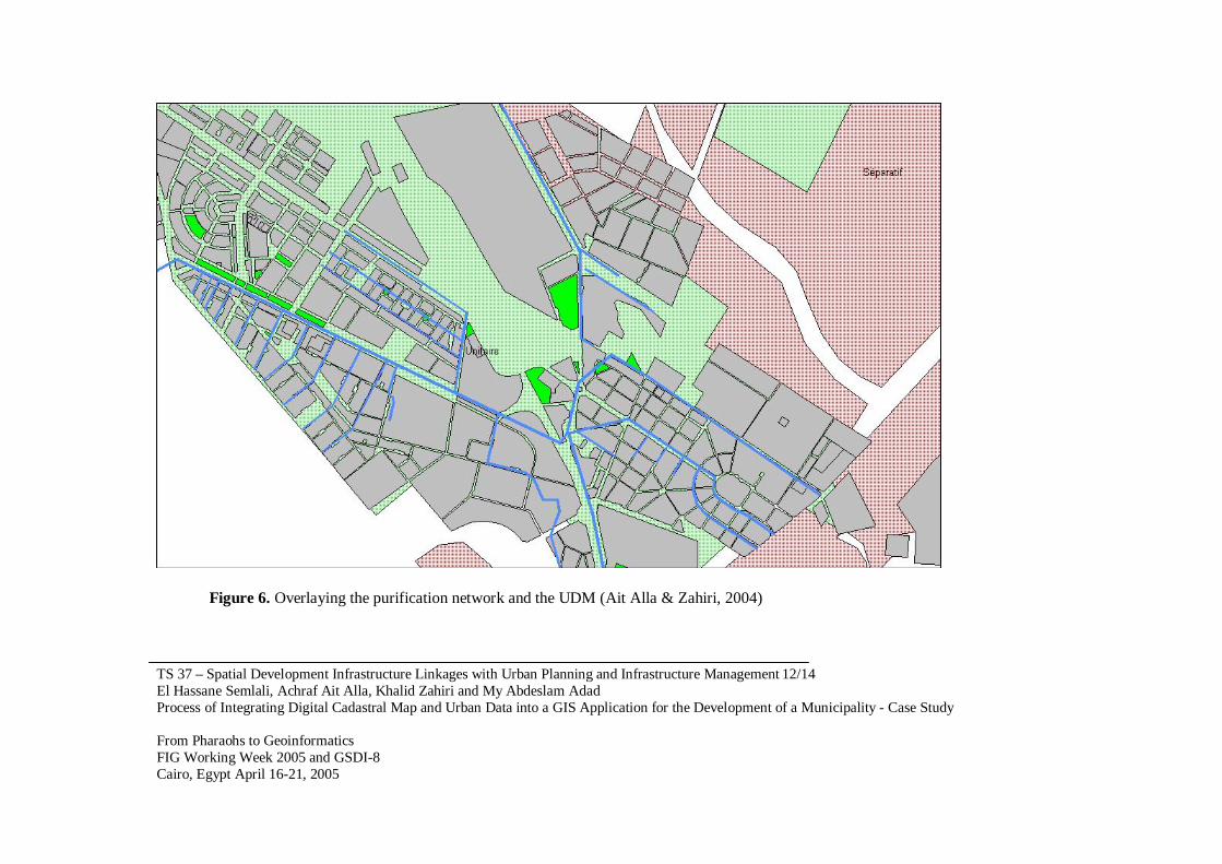
Menu multi-criterion searches This is a powerful tool of research of one or several properties that respect several criterions on the area, the status, the consistence and the affectation in the UDM. This type of query is very useful for the municipality while determining specific sites for managing important projects. Menu data Updating This menu helps the user to update the database. To reach this menu, it is necessary to enter a password, in addition, the cadastral map must be opened. Using the cadastral digital map we have the possibility to add a new title or requisition or to modify the existing ones. The function add is conceived to allow the user to collect all information concerning a property ownership, such as its nature, the number of its boundary-marks as well as their coordinates, the calculated and adopted areas in addition to other complementary information. Once these fields are filled, the information is added to the database and the correspondent spatial entity is created automatically. In order to update the drinking water pipelines data it is necessary to enter a password to control the updating and to limit the access to qualified persons. Once the password accepted, the user has the possibility to add a pipeline using coordinates, or an equipment using the proper symbol. 6. CASE STUDY In order to show the usefulness of this tool, the proposed methodology was tested using a sample data from the municipality of Sidi Kacem as a case study. This city is located in the South-East extremity of the plain of the Gharb, at about 70 Km north of the capital city Rabat. Its area is about 683 ha. The center of the city has a mainly industrial vocation. Hereafter we present some results obtained by the developed GIS application Figure 3 represents the results of the menu statistics, it shows the total number of properties as 8817, with 8623 titles and 194 requisitions, the maximum, minimum and average areas are respectively 3018703; 7 and 3811 m2. Based on these statistics, we can get a fine idea about the advance of land registration process and the zones that have a great demand of registration, therefore the service of cadastre could manage the actions to be taken for further developments. Figure 4 shows the result of searching the title number of all parcels (in red color) encroached by a drinking water pipeline. Figure 5 shows the result of overlaying the drinking water pipelines network and the UDM. Figure 6 is obtained when overlaying the purification network (in blue color) and the UDM.

TS 37 – Spatial Development Infrastructure Linkages with Urban Planning and Infrastructure Management 10/14 El Hassane Semlali, Achraf Ait Alla, Khalid Zahiri and My Abdeslam Adad Process of Integrating Digital Cadastral Map and Urban Data into a GIS Application for the Development of a Municipality - Case Study From Pharaohs to Geoinformatics FIG Working Week 2005 and GSDI-8 Cairo, Egypt April 16-21, 2005
Figure 3. Statistics about cadastral data (Ait Alla & Zahiri, 2004)
Figure 4. Parcels encroached by a pipeline (Ait Alla & Zahiri, 2004)

TS 37 – Spatial Development Infrastructure Linkages with Urban Planning and Infrastructure Management 11/14 El Hassane Semlali, Achraf Ait Alla, Khalid Zahiri and My Abdeslam Adad Process of Integrating Digital Cadastral Map and Urban Data into a GIS Application for the Development of a Municipality - Case Study From Pharaohs to Geoinformatics FIG Working Week 2005 and GSDI-8 Cairo, Egypt April 16-21, 2005
Figure 5. Overlaying the drinking water pipelines network and the UDM (Ait Alla & Zahiri, 2004)
TS 37 – Spatial Development Infrastructure Linkages with Urban Planning and Infrastructure Management 12/14 El Hassane Semlali, Achraf Ait Alla, Khalid Zahiri and My Abdeslam Adad Process of Integrating Digital Cadastral Map and Urban Data into a GIS Application for the Development of a Municipality - Case Study From Pharaohs to Geoinformatics FIG Working Week 2005 and GSDI-8 Cairo, Egypt April 16-21, 2005
Figure 6. Overlaying the purification network and the UDM (Ait Alla & Zahiri, 2004)

TS 37 – Spatial Development Infrastructure Linkages with Urban Planning and Infrastructure Management 13/14 El Hassane Semlali, Achraf Ait Alla, Khalid Zahiri and My Abdeslam Adad Process of Integrating Digital Cadastral Map and Urban Data into a GIS Application for the Development of a Municipality - Case Study From Pharaohs to Geoinformatics FIG Working Week 2005 and GSDI-8 Cairo, Egypt April 16-21, 2005
7. CONCLUSION In this article we have presented a methodology to integrate cadastral data with municipality data into a unique database. Then, we have used this database to develop a GIS tool using Map Basic, Visual Basic, and MapInfo 6. This useful tool will permit: - Interactive management of the geographic data handled by a municipality. - Overly the digital cadastral maps onto the urban development map, and extract useful
information. - Data analysis, processing, updating, and searching. - Respond to some specific queries concerning local geographical information and establish
some thematic maps and statistics. This application was tested using a sample data of the municipality of Sidi Kacem. This application will have several impacts on the development of the municipality such as: - Assist the realization of projects consisting of spatial data. - Contribute to the socioeconomic development of a municipality through facilitating
decision making. - Facilitate the process of analyzing and extracting spatial data. - Develop a consistent spatial reference frame, containing data on land management, and
urban networks as well.
AKNOWLEDGMENT The authors would like to thank the responsible of the Province, the Municipality and the Cadastre of Sidi Kacem for their great cooperation and supplying data used in the case study BIBLIOGRAPHY Ait Alla A. & Zahiri K., 2004. Conception et mise en place d’un prototype SIG pour la
gestion des données cadastrales et urbaines pour la commune de Sidi Kacem, mémoire de 3ème cycle, Filière de Formation en Topogrphie, IAV Hassan II, Rabat
Bellanger F., 2001 : SIG : intérêt pour une commune. Revue XYZ, N°89- 4 trimestre, p : 23, 24, 25, 26.
Boukbech & Essaadi, 2001 : Contribution à l’étude de la modernisation du cadastre marocain, mémoire de 3ème cycle, Filière de Formation en Topographie, IAV Hassan II, Rabat.
ELAyachi M. & Semlali E., 2001: Digital cadastral map: a multipurpose tool for sustainable development. Proceedings of international conference on spatial information for sustainable development , Nairobi, Kenya, 2-5 October 2001.
MapInfo Corporation, 1992. Manuel de référence de MapInfo professionnel 5.0. Copyright MapInfo Corporation, Troy, New York USA, 1992-1994.
Missoumi Ouméria, 2002 . les bases de données cadastrales au service de l’aménagement du territoire. Revue XYZ, N°91-2ème trimestre, p : 52, 53, 54, 55.
Roche S. & Pornon H., 1996. SIG et petites communes. Revue "Géomètre" - N°11 du mois de novembre 1996, p26, 27, 28.

TS 37 – Spatial Development Infrastructure Linkages with Urban Planning and Infrastructure Management 14/14 El Hassane Semlali, Achraf Ait Alla, Khalid Zahiri and My Abdeslam Adad Process of Integrating Digital Cadastral Map and Urban Data into a GIS Application for the Development of a Municipality - Case Study From Pharaohs to Geoinformatics FIG Working Week 2005 and GSDI-8 Cairo, Egypt April 16-21, 2005
WEB SITES
www.cdg85.fr/pages/Internet/interets.htm http://www.urbanisme.equipement.gouv.fr/ http://dittt.gouv.nc/st_info.htm
BIOGRAPHICAL NOTES
El Hassane SEMLALI 1979: Diploma of engineer in surveying from IAV Hassan II, Rabat, Morocco 1986: Master of Science from Ohio State University, Columbus, USA 1999: Doctorate of Sciences from the University of Liege, Belgium. Principal areas of interest are : GIS, geodesy and surveying. Publications: database design, error propagation in GIS, parcel redistribution methodology, GIS in land consolidation, cadastral systems, GPS, development of GIS applications. CONTACTS Professor and researcher El Hassane SEMLALI Institut Agronomique et Vétérinaire Hassan II, Filière de formation en Topographie IAV, Filière de formation en Topographie, B.P. 6202 10101 Rabat Morocco Tel. +212 37 68 03.21 Fax + 212 37 77 81 35 Email: [email protected] [email protected] Web site: www.iav.ac.ma Achraf AIT ALLA, surveying engineer Khalid ZAHIRI, surveying engineer My Abdeslam ADAD; surveying engineer, ex-head of service of cadastre Sidi Kacem,