priority planning area 6 - hopewell, virginia
TRANSCRIPT
Priority Planning Area 6
Rt. 36/I-295 Interchange Commercial District

1
Hopewell Comprehensive Plan – 2018 | 2023
Chapter V1: 36/295 Commercial Corridor District – Priority Planning Area 6
Imagery ©2016 Commonwealth of Virginia, DigitalGlobe, USDA Farm Service Agency, Map data ©2016 Google 1000 ft
Priority Planning Area 6:Rt. 36/295 Corridor Gateway
Commercial District
Priority Planning Areas | Hopewell 2018 Comprehensive Plan
Priority Planning Area 6: Route 36/295 Interchange Commercial District The Route 36/295 Interchange Commercial District (Priority Planning Area 6) represents the onlyinterstate interchangelocatedprimarilywithintheCity. Whilethisplanningareawasproperlytargetedbypriorplansformajorregionalcommercialenterprise,theexistingsub-regionalretailestablishmentsintheNE, SE, andNWquadrants are limited to franchise restaurant, highway-oriented uses, andmodestcommunity-level commerce. TheNEquadrant is furthercompromised for itsattractiveness to regionalandotherlarge-formatretailbytherailroadonthenorthandamixofresidencesonlarge,underutilizedlotsthatextendtotheAshlandStreetintersection.TheSWquadrantislocatedentirelyinPrinceGeorgeCounty. With Hopewell’s three interchange quadrants being substantially built-out, or otherwise infeasible forregional commercial, the southeastquadrant shouldbe viewedas the remainingprime redevelopmentopportunity. The quadrant is currently “anchored” by the underperforming Colonial Corner shoppingcenter,twohotelpropertiesofrecentvintage,oneolderhotelandseveralrestaurants.WhilethecenterhasasignalizedaccesstoOaklawnBoulevardviaColonialCornerDrive,thelayout,age,historyofvacancy,andarchitectural featuresof theshoppingcenterrenders itmarginal,atbest, forattractingthedesireddiversityofqualityretailingenvisionedbytheComprehensivePlan.

2
Hopewell Comprehensive Plan – 2018 | 2023
Chapter V1: 36/295 Commercial Corridor District – Priority Planning Area 6
Imagery ©2016 Commonwealth of Virginia, DigitalGlobe, USDA Farm Service Agency, Map data ©2016 Google 100 ft
B
C
A
Southeast Route 36/295 Quadrant | Candidate Sites for Small Area Plan Areas
The sub-area for the shopping center and contiguous properties has high-density, commercialredevelopment potential and contains over sixteen acres and is designated as Area “A” (see exhibitbelow).IfredevelopedinaunifiedmannerataFAR=0.20,thistractwouldyieldapproximately140,000squarefeetofretailspace.Areas“B”and“C”contain24.3acresand8.3acres,respectively.IfArea“B”were to be developed for high density residential (14-16 units/acre) in a TND format, it couldaccommodatebetween300and400garden-styledmultifamilydwellings.Area“C”,asmallareaofwhichis currently developed, would have the capacity for an additional 30,000-50,000 square feet ofcommercialspace. Tobetterrecognizetherelationshipof thesesub-areas, it is recommendedthattheCity initiateaSmallAreaPlantoevaluateoptionsforthecomprehensiveredevelopmentofthesethreeproperties. The plan should emphasize the need for internal transportation interconnectivity andestablishanofficialmapalignmentfortheextension“ofAshlandStreet(seefollowingpage.)

3
Hopewell Comprehensive Plan – 2018 | 2023
Chapter V1: 36/295 Commercial Corridor District – Priority Planning Area 6
423 Feet
139 Feet
1136
Feet
EMORY RD OAKLAWN BLVD
OAKLAW
N BLV
D
WOO
DLAW
N ST
OLD W
OODLAW
N ST
COLONIAL CORNER DR
OAKLAWN BLVD
OAKLAWN BLVD
OLD W
OODLAW
N ST
OLDOAKLA
WN
BVD
OLD OAKLAWN BVD
C OURTHOUSE RD
COURTHOUSE RD
WOODLAW
NST
WOO
DLAW
NST
PROPOSED ST
PROPO
SED
ST
PROPO
SEDST
PIPER SQUARE DR
PIPER SQUARE DR
PIPER SQUAREDR
¯Imagery, Copyright 2013
Commonwealth of Virginia
Redevelopmentopportunities,asdescribedontheprecedingpage,donotcomewithoutchallenges:TheAshlandStreetconnectiontotheColonialCornersiteisessentialtoensureareasonablequalityofaccess
andcapacityoftransportationservicesforthePriorityPlanningArea.
AshlandStreetConnector
If Priority PlanningArea 6 is to ever flourish as a viable commercial hub, the Citywill have to addresstrafficimpactshortcomingsinandaroundtheinterchange.Thedesignandlocationofthecurrentsinglefull access intersection is one contributor to the physical and economic inefficiency of the existingcommercialproperties. Adding to thearea’s transportationdeficiencies is the convolutedconvergencedesignofWoodlawnStreetandOaklawnBoulevardinsuchcloseproximitytotheI-295Interchange.Giventheincreasedtrafficgenerationpotentialfortheoptimalbuild-outoftheplanningarea,trafficwillfunction poorly at best without a transportation plan that includes alternative access. It has beenpreviouslydocumentedthattheexistingaccesspointsservingtheplanningareaare“limited,restricted,andconstricted”. Basedontechnical input fromtheCityEngineer, theprobabilityofmajorcongestionpointisacertaintyifamajoranchorstoreandotherhightrafficgeneratorslocateinthisquadrant.Amajorimprovementforthesoutheastquadrantofthe36/295CommercialCorridorDistrictwouldbetoproceedwith the long-discussedAshland Street connector to the Colonial Corner site (shown in photoexhibitabove).ThisextensionhasbeenselectedbyVDOTandtheMPOasaworthycandidatetoreceivefutureyearsfunding.TheCityneedstoproceedwithit.Forimmediateaction,theCitymustfinalizethetrafficimpactstudyandtransportationdesigndetailsfortheprojecttoensurethattheright-of-waycanbe securedwithout compromise.Any future sitedevelopment shouldeitheragree to: (1)dedicate theright-of-way, (2) build the extension, (3) build a portion of the extension, or (4) undertake somecombination of all these steps. Basedon transportation action plan recommendations, the connectorcould also be pursued via an economic development partnership between the City and developers.However,thisisaconnectionthatmustbemadetoensuretherevitalizationofthisplanningarea.
4
Hopewell Comprehensive Plan – 2018 | 2023
Chapter V1: 36/295 Commercial Corridor District – Priority Planning Area 6
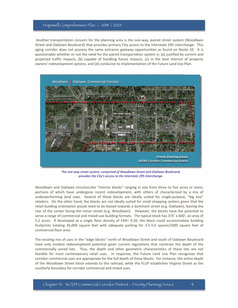
Woodlawn | Oaklawn Commercial Corridor
Priority Planning Area 6:36/295 Corridor Commercial District
Woodlawn Street
Oaklawn Boulevard
Theone-waystreetsystem,comprisedofWoodlawnStreetandOaklawnBoulevard,providestheCity’saccesstotheInterstate295interchange.
Another transportationconcern for theplanningarea is theone-way,pairedstreet system(WoodlawnStreetandOaklawnBoulevard)thatprovidesprimaryCityaccesstotheInterstate295interchange.Thisaging corridor does not possess the sameentrance gatewayopportunities as foundonRoute 10. It isquestionablewhetherornottheneedforthepairedtransportationsystemis:(a)justifiedbycurrentandprojected traffic impacts, (b) capable of handling future impacts, (c) in the best interest of propertyowners’redevelopmentoptions,and(d)conducivetoimplementationoftheFutureLandUsePlan.
WoodlawnandOaklawncircumscribe“interiorblocks” ranging insize fromthreeto fiveacresormore,portions of which have undergone recent redevelopment, with others of characterized by a mix ofunderperforming land uses. Several of these blocks are ideally suited for single-purpose, “big box”retailers. Ontheotherhand,theblocksarenot ideallysuitedforsmallshoppingcentersgiventhattheretailbuildingorientationwouldneedtobebiasedtowardsadominantstreet(e.g.Oaklawn),leavingtherearofthecenter facingtheminorstreet (e.g.Woodlawn). However, theblockshavethepotential toservearangeofcommercialandmixed-usebuildingformats.Thetypicalblockhas375’x600’,anareaof5.2 acres. If developed at a single floor density of FAR= 0.20, the block could accommodate buildingfootprints totaling 45,000 square feet with adequate parking for 3.5-5.0 spaces/1000 square feet ofcommercialfloorarea.Theexistingmixofusesinthe“edgeblocks”northofWoodlawnStreetandsouthofOaklawnBoulevardhave only modest redevelopment potential given current regulations that constrain the depth of thecommercially zoned lots. Thus, the depth and other geometric characteristics of these lots are notfeasible for most contemporary retail uses. In response, the Future Land Use Plan recognizes thatcorridorcommercialusesareappropriateforthefulldepthoftheseblocks.Forinstance,theentiredepthof theWoodlawnStreetblockextends to the railroad,while theFLUPestablishesVirginiaStreetas thesoutherlyboundaryforcorridorcommercialandmixeduses.
5
Hopewell Comprehensive Plan – 2018 | 2023
Chapter V1: 36/295 Commercial Corridor District – Priority Planning Area 6
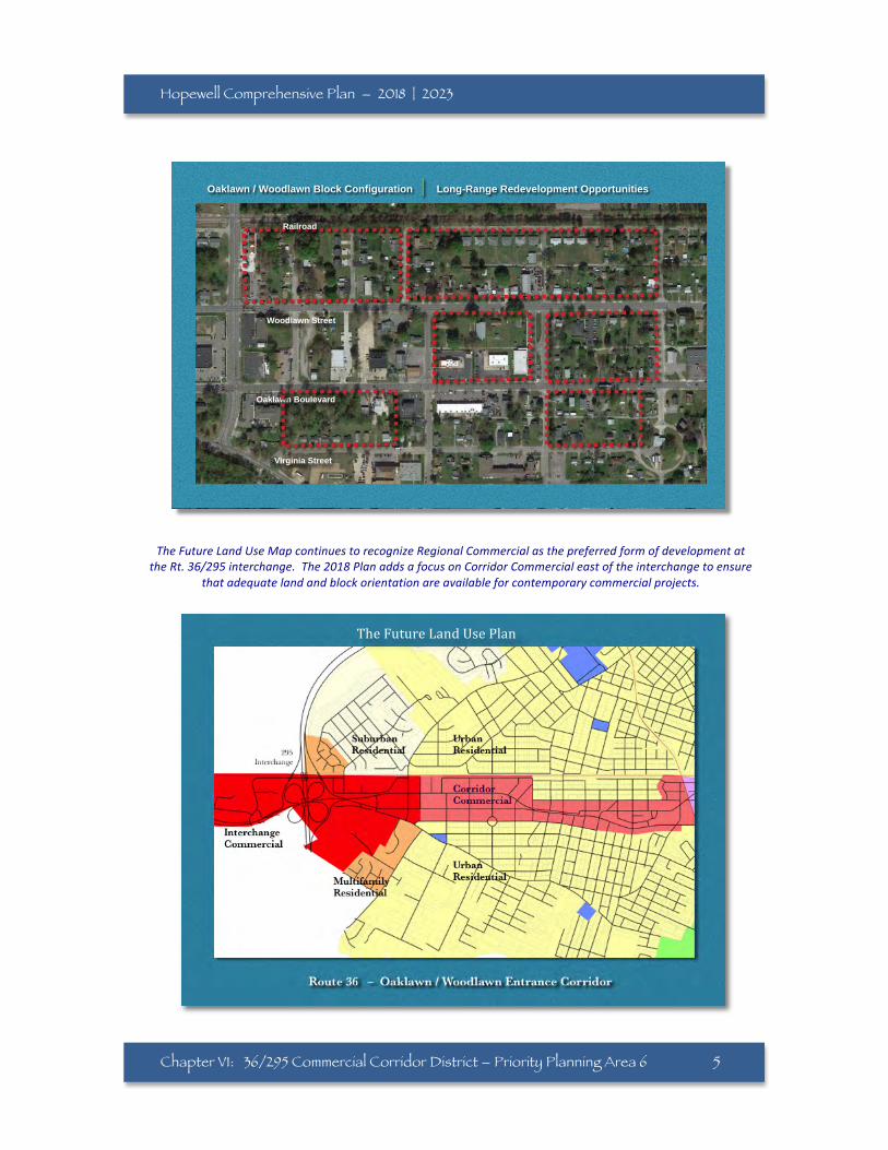
TheFutureLandUseMapcontinuestorecognizeRegionalCommercialasthepreferredformofdevelopmentattheRt.36/295interchange.The2018PlanaddsafocusonCorridorCommercialeastoftheinterchangetoensure
thatadequatelandandblockorientationareavailableforcontemporarycommercialprojects.
Imagery ©2016 Commonwealth of Virginia, DigitalGlobe, USDA Farm Service Agency, Map data ©2016 Google200 ft
Oaklawn / Woodlawn Block Configuration |""Long-Range Redevelopment Opportunities
Woodlawn Street
Oaklawn Boulevard
Virginia Street
Railroad
TheFutureLandUsePlan