principal cycle network for far north queensland/media/projects/p/principal cycle network...
TRANSCRIPT

Appendix BLink concepts and concept designs
Locality plan 48
Mossman to Port Douglas 49
Ellis Beach to Palm Cove 53
Smithfield to Palm Cove 55
East Mareeba to Mareeba central business district 58
Yungaburra to Lake Eacham 61
Goondi Hill to Johnstone College of TAFE Innisfail 63
Etty Bay Road 65
Bingil Bay to South Mission Beach 68

Principal Cycle Network Plan for Far North Queensland Department of Transport and Main Roads 47
Principal Cycle Network Plan
Far North Queensland
Preparing a link concept and concept design is a bridging step between identifying a high
priority principal cycle route and initiating a construction project to deliver a specific part
of the network. This step represents a starting point for attracting funds and progressing
detailed design.
What is a link concept?A link concept provides background information
for the route and supports the concept design.
This information includes:
a description of the link, existing conditions
and recommended standards
potential issues such as traffic and parking
considerations
the strategic relationship to surrounding
areas and overall network priorities.
Link concepts provide guidance when
undertaking detailed planning and design to
implement the link.
What is a concept design?A concept design shows the proposed alignment
for a selected route which is further broken
into sections to indicate areas where different
treatments are required. Treatments to upgrade
existing conditions to better provide for cyclists
are proposed for each section. Treatments
may include providing on-road bicycle lanes or
constructing off-road shared paths. Crossing
structures and problem areas such as bridges
and intersections are also identified on concept
designs. This information can be used to develop
cost estimates and prepare a business case for
constructing a project.
Concept designs represent an idea of what might
be achieved. Detailed design, combined with
stakeholder consultation, determine the specific
treatments and physical alignment of the facility
before taking the project forward to construction.
Reading link conceptsLink concepts support the concept designs by
providing the background information for each
proposed link alignment.
Information contained in link concepts provides
guidance when undertaking detailed planning
and design to construct a principal cycle route.
Link concepts include:
strategic positioning - the strategic
relationship of the link to the surrounding
area and network priorities
proposed standards - a description of
construction treatments proposed for each
section
conditions and form - a brief overview
of existing conditions on the route and
potential issues such as traffic and parking
considerations.
The information in link concepts is useful for
understanding why the link is important, why
certain treatments have been proposed and
what issues might need to be addressed before
constructing the route.
The link concepts may need to be updated in
the future to reflect changes to conditions or
construction standards prior to constructing a
principal cycle network project.
Understanding concept designsThe concept designs provided in the Principal
Cycle Network Plan for Far North Queensland
provide a starting point to deliver high priority
cycle projects for the region.
These concept designs are not final plans for
constructing cycle facilities. They are a first step
toward identifying and suggesting appropriate
construction treatments along different sections
of a principal cycle route.
A proposed link alignment is shown on each
concept design and broken into different
coloured sections. Each section represents a
change in the conditions along the corridor
and indicates where a different construction
treatment is required. Above each section is a
brief description of the proposed construction
treatment.
The ‘chainage’ along the route is provided for
most concept designs. This shows the number of
metres from the start of the route to the start and
end of each section. Knowing the length of the
treatment type proposed for each section helps
to develop cost estimates for constructing all the
different parts of the route. Extra details such as
notes and photographs are also provided on the
concept designs. Some of the terms appearing
on the concept designs are explained on the
right side of this page.
The concept designs provide an overall idea
of what cycle facilities might be achieved on a
particular part of the principal cycle network.
The routes depicted in the concept designs will
require further investigation to determine if the
proposed treatments are feasible. For some
routes, consultation with stakeholders and the
community will be necessary to help decide the
most appropriate treatments for constructing the
route. Detailed investigations may also consider
alternative locations for all or part of a principal
cycle route such as using a parallel street or
nearby green corridor. The alignment of a route
may change if alternative options provide similar
or greater benefits to cyclists with fewer impacts
or lower construction costs.
Contact the Department of Transport and Main
Roads if you would like further information about
the concept designs.
Terms
Bicycle awareness zone Yellow bicycle symbols marked on the road surface indicate a shared zone
for cyclists and vehicular traffic. These symbols are typically only applied in
low speed environments along local roads where their use is approved by
the local authority. Further consideration of traffic calming may be required
in these locations.
Bike lane A bike lane is typically an on-road facility extending from the outer edge of
the vehicle traffic lane. A bike lane is usually between 1.2–1.5 metres wide
along roads with up to 60km/hr speed limits. Bicycle lanes can be up to 2.5
metres wide in busier sections of 60km/hr roads and up to 3 metres along
roads with speed limits above 60km/hr.
Bike path A bike path is typically an off-road facility specifically designed to cater to
cyclists.
Cantilever structure Where the road environment is constrained by sloping terrain, a path
can be extended over the sloping edge using a cantilevered structure.
Such structures will also require safety rails built to standard height and
clearances.
Clearances Cycle routes must be set back from trees, posts, signage, drains, guardrails,
sloping edges, kerbs and other obstacles to prevent collisions.
Shared path A shared path is an off-road facility designed to cater for use by both
cyclists and pedestrians, and is usually a minimum of 2.5 metres wide.
Shared zone These spaces, usually roads, are shared by cyclists and vehicular traffic.
Traffic calming may be required in these locations to keep speeds low.
Transition treatment A transition treatment is required to enable safe movement between off-
road cycle facilities and on-road cycle facilities, and also when a cycle path
crosses a road.
Transport corridor A strategic corridor identified for future vehicle or public transport use.
These corridors present an opportunity for use by cyclists.
Appendix B: Link concepts and concept designs
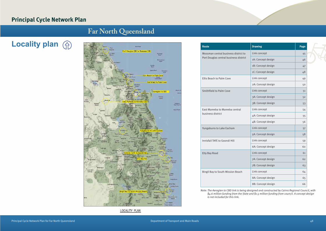
Principal Cycle Network Plan for Far North Queensland Department of Transport and Main Roads 48
Principal Cycle Network Plan
Far North QueenslandRoute Drawing Page
Mossman central business district to
Port Douglas central business district
Link concept 45
1A: Concept design 46
1B: Concept design 47
1C: Concept design 48
Ellis Beach to Palm Cove Link concept 49
2A: Concept design 50
Smithfield to Palm Cove Link concept 51
3A: Concept design 52
3B: Concept design 53
East Mareeba to Mareeba central
business district
Link concept 54
4A: Concept design 55
4B: Concept design 56
Yungaburra to Lake Eacham Link concept 57
5A: Concept design 58
Innisfail TAFE to Goondi Hill Link concept 59
6A: Concept design 60
Etty Bay Road Link concept 61
7A: Concept design 62
7B: Concept design 63
Bingil Bay to South Mission Beach Link concept 64
8A: Concept design 65
8B: Concept design 66
Locality plan
Note: The Aeroglen to CBD link is being designed and constructed by Cairns Regional Council, with
$4.6 million funding from the State and $1.5 million funding from council. A concept design
is not included for this link.

Principal Cycle Network Plan for Far North Queensland Department of Transport and Main Roads 49
Principal Cycle Network Plan
Far North Queensland
Strategic positioning
Link description
The proposed principal cycle route begins at
the intersection of Captain Cook Highway and
Bow Street, Mossman. It heads in a southerly
direction, along the Captain Cook Highway to
Port Douglas. At the intersection of Captain
Cook Highway and Port Douglas Road, the route
follows Port Douglas Road to the Port Douglas
centre, where it then follows Macrossan Street,
terminating at the intersection of Macrossan
Street and Wharf Street.
Strategic position
This link is part of a prioritised corridor in the
Cairns Regional Council section of the Principal
Cycle Network Plan for Far North Queensland.
The link will connect two district regional activity
centres of Mossman and Port Douglas to provide
a connection for residents to these centres as
well as catering for tourists and recreational
users.
This link is shown in Map 3 and Map 4 of the
Network Maps.
Concept design
The link and its associated sections is detailed
on Drawing No’s 1A, 1B and 1C.
Link owner
The principal cycle route along the Captain Cook
Highway and Port Douglas Road are both state-
controlled, whilst the cycle routes proposed
along Davidson Street and Macrossan Street are
Cairns Regional Council controlled roads.
Connection priority
The route ranked in the top 25 routes for this
region. The Port Douglas component of the route
ranked as the top priority for the former Douglas
Shire Council local government area. At the
stakeholder workshop, the route was identified
as being one of the top 10 priority routes for the
region. Key aspects relating to its priority are
that:
it was identified as a priority link during the
stakeholder consultation processes
the route ranked highly in terms of the
number of attractors it serves and the variety
of these attractors along the route
there is also a medium level of heavy vehicle
use along the route.
Proposed treatments
Section 1 (Captain Cook Highway between
Bow Street and south of Harper Street)
through the Mossman centre area comprises
bike lanes
Section 2 (Captain Cook Highway between
Harper Street and the rail line crossing (near
Shannonvale Road) through the southern
urban area of Mossman comprises a 3.5m
shared path. In this section an alternative
route for investigation is also proposed
along Shannonvale Road due to potential
limitations in road reserve widths along the
Captain Cook Highway and potential to reduce
bridge widening requirements
Sections 3 and 4 along the Captain Cook
Highway (between the rail line crossing near
Shannonvale Road and 500m north of Port
Douglas Road) consists of 2.5m shared path
Section 5 along Port Douglas Road (between
the Captain Cook Highway and Macrossan
Street) consists of 3.5m shared path
Section 6 along Macrossan Street (between
Port Douglas Road and Grant Street) consist of
on-road bike lanes
Section 7 along Macrossan Street (between
Grant Street and Wharf Street) consists of a
new path.
Mossman to Port Douglas It is noted that along Port Douglas Road
where an off-road shared path is proposed,
on-road cycle facilities should also be
provided as either a formal cycle lane or as
part of the road shoulder. This may be able to
be implemented as part of line marking and
re-sheeting programs. Some sections already
exist.
Off-road paths (existing and proposed)
should also be designed and assessed
according to Crime Prevention Through
Environmental Design principles with regular
maintenance of shrubs and vegetation to
improve visibility and increase security.
Conditions and form
Existing conditions
A commuter and recreational facility exists along
Port Douglas Road and also along sections of the
Captain Cook Highway in south Mossman. There
are also some bike lanes recently implemented
on Port Douglas Road near the shopping centre.
Otherwise, no other cycle facility currently exists.
Interaction issues with other traffic
There are currently no cycle facilities on the
Captain Cook Highway (except within urban
area of Mossman central business district), and
cyclists currently have to mix with traffic. The
Captain Cook Highway forms a major highway
link between Cairns and Mossman and Port
Douglas.
Off-road paths are proposed to minimise the
interaction of cyclists and motorised traffic along
the Captain Cook Highway, with the exception of
bicycle lanes in the Mossman central business
district where the traffic speeds are much lower
and there is a higher level of pedestrian activity
associated with the adjacent land use in the
commercial area.
A similar on-road facility has been proposed
in the Port Douglas central business district
except where proposed works associated
with the Port Douglas Waterfront Master Plan
may result in a cycle facility separated from
pedestrians
Other operational issues
Section 1 can be achieved through proposed
Department of Transport and Main Roads
upgrading plans, which incorporate on-road
bike lanes in the urban area of Mossman
central business district.
There is a need to further investigate how
to achieve cycle facilities across bridge
crossings. These investigations will include
the possibility of the requirment of a separate
bridge.
Section 7 could be delivered as part of the Port
Douglas Waterfront Master Plan project.
Known potential issues/risks
Macrossan Street – the proposed facility north
of Grant Street to be considered in conjunction
with the outcomes of the Port Douglas
Waterfront Master Plan project. This may
require removal of some existing vegetation.
Link concept - Mossman to Port Douglas

Principal Cycle Network Plan Far North Queensland
Principal Cycle Network Plan for Far North Queensland Department of Transport and Main Roads 50
Concept design - Mossman to Port Douglas

Principal Cycle Network Plan Far North Queensland
Principal Cycle Network Plan for Far North Queensland Department of Transport and Main Roads 51
Concept design - Mossman to Port Douglas
Drawing No. 1B

Principal Cycle Network Plan Far North Queensland
Principal Cycle Network Plan for Far North Queensland Department of Transport and Main Roads 52
Concept design - Mossman to Port Douglas
Drawing No. 1C

Principal Cycle Network Plan for Far North Queensland Department of Transport and Main Roads 53
Principal Cycle Network Plan
Far North Queensland
Strategic positioning
Ellis Beach to Palm Cove
Link description
The link begins along the Captain Cook Highway
at Ellis Beach. From here, it travels south, along
the Captain Cook Highway and terminates at
the intersection of Captain Cook Highway, Cedar
Road and Veivers Road at Palm Cove.
Strategic position
This link is part of a prioritised corridor in the
Cairns Regional Council section of the Principal
Cycle Network Plan for Far North Queensland.
The principal cycle route will connect the Ellis
Beach recreation/tourist area with the Palm Cove
recreation/tourist area and locality. The route
will form an iconic recreation and tourist facility
for far north Queensland. The route forms stage
one of an overall priority corridor between Port
Douglas and Palm Cove.
This link is detailed in Map 5 of the Network
Maps.
Concept design
The link and its associated sections is detailed
on Drawing No. 2A.
Link owner
The principal cycle route traverses the Captain
Cook Highway which is a state-controlled road
and as such Department of Transport and Main
Roads is responsible for this link.
Connection priority
The route was confirmed as a priority at the
Stakeholder Prioritisation Workshop which
involved State agencies, local governments
and bicycle user groups. Key aspects relating to
its priority status were related to the potential
attractiveness of the route to form an iconic
tourist and recreational route in the far north
Queensland region.
Proposed treatments
The majority of the path is proposed as a 2.5m
shared path, except where road reserve widths
limit its width to 2.0m (Section 2) and at Ellis
Beach where a wider path is proposed (Section 1
at 3.5m) due to higher demands by pedestrians
and cyclists as a result of adjacent land uses.
The off-road path should also be designed
and assessed according to Crime Prevention
Through Environmental Design principles with
regular maintenance of shrubs and vegetation to
improve visibility and increase security for users.
Conditions and form
Existing conditions
The link will serve a recreational and tourist
facility with some commuter use. Currently there
are no specific cycle facilities existing along the
route.
Interaction issues with other traffic
The route traverses the Captain Cook Highway
which is a major highway connecting Cairns with
Port Douglas and Mossman. The highway has
high traffic volumes and speeds. As a result, an
off-road path has been proposed.
Other operational issues
The construction of this route presents
significant challenges. There are some sections
where a boardwalk and cantilever construction
types are required due to the proposed route’s
position along the coast with limited space for
widening the road. The construction of these will
need to be robust to address potential future
erosion of the coastline. The type of facility
proposed should retain the view and outlook to
the coast.
Known potential issues/risks
The known potential issues/risks include the
environmental impacts along the foreshore
associated with construction of this facility.
Link concept - Ellis Beach to Palm Cove

Principal Cycle Network Plan Far North Queensland
Principal Cycle Network Plan for Far North Queensland Department of Transport and Main Roads 54
Concept design - Ellis Beach to Palm Cove
Drawing No. 2A

Principal Cycle Network Plan for Far North Queensland Department of Transport and Main Roads 55
Principal Cycle Network Plan
Far North Queensland
����������� �������
Strategic positioning
Link description
The link begins at the intersection of Captain
Cook Highway and Kennedy Highway. From this
point, the link heads in a northerly direction
along Captain Cook Highway, until Feathertop
Close, whereupon it leaves the road corridor
and heads in an easterly direction across the
proposed Smithfield Town Centre near McGregor
Road. It continues along the new intersuburban
connector road through Smithfield Village
estate and Bluewater, then travels along the
disused cane rail corridor to Poolwood Road. At
Trinity Beach it connects into Cottesloe Drive,
continuing north-west before traversing a new
development area and connecting into Rudder
Street.
The principal cycle route then traverses local
residential streets through Clifton Beach and
Palm Cove. Specifically it traverses north south
via Rudder Street, Hope Street, Undine Street,
Batt Street, Pixie Street, Arlington Esplanade,
St Crispin Street, Guide Street, Clifton Road,
Yule Avenue, Beaver Street, Saxon Street,
Endeavour Road, Haycock Street, Satellite
Street, Linden Street and Argentea Boulevard. It
then heads east along Deep Acres Drive, north
along Triton Street, Veivers Road and Williams
Esplanade until it reaches Cedar Road. The
route then traverses east west along Cedar Road
until Warren Street, which it traverses before
terminating at the intersection of Warren Street
and Captain Cook Highway.
Strategic position
This link is part of a prioritised route in the Cairns
Regional Council section of the Principal Cycle
Network Plan for Far North Queensland. The link
will connect the Smithfield major regional activity
centre with the northern beaches residential
areas and the Palm Cove tourist area. It also
provides connectivity for local residents to
local beaches and local shops along the way.
Smithfield contains major services, shops,
community facilities and employment areas for
these residential areas.
This link is detailed in Map 5 and Map 6.
Concept design
The link and its associated sections is detailed
on Drawing No’s 3A and 3B of the Network Maps.
Link owner
Most of the roads that the principal cycle route
traverse are Cairns Regional Council controlled
roads, with the exception of the Captain Cook
Highway which is state-controlled and as such
Department of Transport and Main Roads has
stewardship of this section of the link.
Connection priority
A prioritisation process was undertaken and
this route was identified as being in the top 10.
The route was also confirmed as a priority at a
stakeholder workshop, involving state and local
governments and bicycle user groups.
Key aspects relating to its high priority area were
as follows:
it was identified as a priority link during the
stakeholder consultation processes
the route ranked highly in terms of the
number of attractors it serves and the variety
of these attractors along the route
there is a high population of potential cyclists
located within its catchment
there was an opportunity to achieve cycle
facilities as part of the planning and
development of the proposed Cairns Transit
Network.
Proposed treatments
Sections 1 and 2 (Captain Cook Highway
between Kennedy Highway and Poolwood
Road) comprise a 3.0m off-road path to be
constructed alongside the new intersuburban
connector road between McGregor Road and
Reed Road, then as a stand-alone bikeway
along the disused cane rail corridor between
Reed Road and Poolwood Road
Section 3 (Cottesloe Drive) comprises an
on-road yellow advisory treatment along the
residential street
Sections 4 and 5 (Cottesloe Drive to Rudder
Street) comprise a 3.0m path as part of future
development area
Sections 6-8 (between Linden Street and
Hope Street) comprise an on-road yellow
advisory treatment along local residential
streets
Sections 9-12 (Deep Acres Drive, Agentea
Boulevard, Linden Street) comprises the
existing 2.5m path and a proposed bike lane
Sections 13-14 (Deep Acres Drive and Triton
Street) comprise a future bike lane
Section 15 (Williams Esplanade, Veivers Road)
comprises a 3.5m shared path along the
foreshore
Section 16 (Cedar Road) comprises a bike
lane
Section 17 (Warren Street) comprises a 2.5m
shared path.
Conditions and form
Existing conditions
This link will serve a commuter and recreational
facility. Existing shared paths and cycle lanes
exist in some parts of the route, although not in
a continuous manner. There is also an off-road
shared path along parts of the Captain Cook
Highway in the vicinity.
Interaction issues with other traffic
Some sections of the proposed route are bicycle
advisory treatments where cyclists will share
the road with other users. These streets are low
volume and low speed local residential streets
and therefore this is considered appropriate.
This treatment is subject to approval by the
local authority. The section of bikeway proposed
as part of the transport corridor represents an
opportunity to deliver a separated bikeway
through the new residential estates of Smithfield
Village and Bluewater, either alongside the
new intersuburban connector road or within the
disused cane rail corridor. Further discussion is
required with council, the Cairns Transit Network
project team and private developers.
Other operational issues
A separated bicycle facility needs to be
incorporated into the planning and design
for future use of the transport corridor and
constructed at the same time. A large percentage
of the proposed principal cycle route traverses
local residential streets through Clifton Beach
and Palm Cove. The route is indirect and is
currently not very legible to cyclists. As a result,
it will require significant signage to improve its
legibility. The cycle facility proposed will also
allow a north south connection through these
suburbs which is not possible to undertake by
car.
Known potential issues/risks
There are no known potential issues/risks.
�������������������������� �������

Principal Cycle Network Plan Far North Queensland
Principal Cycle Network Plan for Far North Queensland Department of Transport and Main Roads 56
��������������������������� �������
Drawing No. 3A

Principal Cycle Network Plan Far North Queensland
Principal Cycle Network Plan for Far North Queensland Department of Transport and Main Roads 57
��������������������������� �������
Drawing No. 3B

Principal Cycle Network Plan for Far North Queensland Department of Transport and Main Roads 58
Principal Cycle Network Plan
Far North QueenslandLink concept - Mareeba East to Mareeba central business district
Mareeba East to Mareeba central business districtStrategic positioning
Link description
The link begins at the intersection of Peninsula
Developmental Road and Mareeba Dimbulah
Road, from which it travels south along Peninsula
Developmental Road. At the intersection of
Peninsula Developmental Road and Rankin
Street, it heads east along Rankin Street and
then south along Constance Street. At the
intersection of Constance Street and Herberton
Street, the link follows Herberton Street, to the
east. The route crosses the Barron River into
Anzac Avenue. It continues south-east along
Anzac Avenue, terminating at the intersection of
Anzac Avenue and Elisa Avenue.
Strategic position
This link is part of a prioritised route in the
Tablelands Regional Council area of the Principal
Cycle Network Plan for Far North Queensland.
The primary purpose of the link is to connect
the residential areas to the east and west of
Mareeba to the central business district, which
is a major regional activity centre. The central
business district contains a number and variety
of attractors, including the Mareeba rail station,
a library and major shopping centres and
employment. A golf course is also located to the
north of the proposed cycle route.
This link is detailed in Map 16 of the Network
Maps.
Concept design
The link and its associated sections is detailed
on Drawing No’s 4A and 4B.
Link owner
The principal cycle route along the Peninsula
Development Road is a state-controlled road.
All other roads which the principal cycle
route traverses are owned and maintained by
Tablelands Regional Council.
Connection priority
A prioritisation process was undertaken and key
parts of the route were in the top three priority
routes for the former Mareeba Shire Council local
government area. The link was then consequently
proposed as a priority route at a stakeholder
prioritisation workshop, involving state agencies,
local governments and bicycle users.
Key aspects relating to its high priority are as
follows:
parts of the route ranked highly in terms of
the number of attractors it serves and the
variety of these attractors along the route
part of the route has a high volume of heavy
vehicles (Peninsula Development Road).
Proposed treatments
Section 1 (Peninsula Developmental Road,
between Mareeba Dimbulah Road and
Railway Avenue) comprises a 3.0m shared
path, replacing the existing path
Section 2 (Peninsula Developmental Road,
between Railway Avenue and Rankin Street)
comprises an on-road cycle lane
Section 3 (Rankin Street) comprises on-road
bike lanes
Sections 4 (Constance Street) comprises a
new 3.0m shared path
Section 5 (Herberton Street, between
Constance Street and Barron River) comprises
retaining the existing Copenhagen style bike
lane
Section 6 (Anzac Avenue over the Barron
River) will comprise a wider version of the
existing shared path facility (3.0m)
Section 7 (Anzac Avenue to just north of
Hastings Drive) comprises a new 3.0m shared
path
Section 8 (Anzac Avenue between Hastings
Drive and Elisa Avenue) will comprise a new
3.0m shared path, replacing the existing
facility
Off-road paths (existing and proposed)
should also be designed and assessed
according to Crime Prevention Through
Environmental Design principles with regular
maintenance of shrubs and vegetation to
improve visibility and increase security.
Conditions and form
Existing conditions
There is an existing bike path along Peninsula
Developmental Road, between Mareeba
Dimbulah Road and Byrnes Street, however this
will be replaced with a wider path. In addition,
there is an existing Copenhagen style bike lane
along Herberton Street. Anzac Avenue also has
some existing pathways, though these will be
replaced with wider facilities.
Interaction issues with other traffic
The majority of the principal cycle route is
proposed as an off-road shared path. The
sections that are proposed as on-road bicycle
lanes are through the main commercial area in
the Mareeba central business district on Rankin
Street and Peninsula Developmental Road due to
the high levels of commercial activity as a result
of adjacent land use. The Peninsula Development
Road is a major through traffic route in the area
with traffic volumes of 11,500 trips per day,
connecting Atherton with Mareeba and Mt Molloy
and Mossman to the north.
Other operational issues
The other operational issues include the
widening of pedestrian and cycle facilities on the
Barron River bridge at Anzac Avenue and over the
creek along Peninsula Development Road north
of Railway Avenue.
Known potential issues/risks
There is a potential issue/risk associated
with changing the number of traffic lanes on
Peninsula Development Road from four lanes to
two lanes through the central business district.
Further investigation will be required to see if
this is possible and will need to be assessed
in association with consultation with the local
authority and the community.

Principal Cycle Network Plan Far North Queensland
Principal Cycle Network Plan for Far North Queensland Department of Transport and Main Roads 59
Concept design - Mareeba East to Mareeba central business district
Drawing No. 4A

Principal Cycle Network Plan Far North Queensland
Principal Cycle Network Plan for Far North Queensland Department of Transport and Main Roads 60
Concept design - Mareeba East to Mareeba central business district
Drawing No. 4B

Principal Cycle Network Plan for Far North Queensland Department of Transport and Main Roads 61
Principal Cycle Network Plan
Far North Queensland
Strategic positioning
Yungaburra to Lake Eacham
Link description
The link begins at the entrance to Yungaburra
town along Gordonvale Atherton Road and
continues along Gordonvale Atherton Road
through Yungaburra and towards Lake Eacham.
At the intersection of Gordonvale Atherton Road
and Byrnes Road the route leaves Gordonvale
Atherton Road and traverses Byrnes Road to Lake
Barrine Road. The link crosses Lake Barrine Road
connecting to Lake Eacham Road and traversing
this road, before terminating immediately south
of the intersection of Lake Eacham Road and
Malanda Lake Barrine Road.
Strategic position
This link is part of a prioritised route in the
Tablelands Regional Council area of the Principal
Cycle Network Plan for Far North Queensland.
The link will connect the Yungaburra Village
Activity Centre with the Lake Eacham regional
tourist/recreation facility. The route forms stage 1
of an overall corridor link between Atherton and
Lake Barrine.
This link is detailed in Map 20 of the Network
Maps.
Concept design
The link and its associated sections are detailed
on Drawing No. 5A.
Link owner
The majority of the proposed principal cycle
route is along Gordonvale Atherton Road which
is state-controlled and as such the Department
of Transport and Main Roads has responsibility
for those sections of the link. The Tablelands
Regional Council controls the remaining roads
that the principal cycle route crosses.
Connection priority
The route was confirmed as a priority at the
stakeholder prioritisation workshop, involving
state agencies, local governments and bicycle
users.
Key aspects relating to its priority status were
related to its potential attractiveness to form
an iconic tourist and recreational route in the
far north Queensland region. It has also been
identified a number of times throughout the
stakeholder consultation process undertaken in
developing the Principal Cycle Network Plan for
Far North Queensland.
Proposed treatments
Section 1 (Gordonvale Atherton Road between
Peterson Creek and Fig Street) comprises a
3.0m shared path
Section 2 (Gordonvale Atherton Road
between Fig Street and Beech Street)
comprises a 3.0m shared path
Section 3 (Gordonvale Atherton Road
between Beech Street and Byrnes Road)
comprises a 2.5m shared path
Section 4 (Byrnes Road) comprises a 2.5m
shared path
Section 5 (Lake Eacham Road) comprises a
bicycle advisory treatment
It is noted that where an off-road shared path
is proposed, on-road cycle facilities should
also be provided as part of the road shoulder.
This could be implemented as part of any
proposed road upgrades along this link
Off-road paths (existing and proposed)
should also be designed and assessed
according to Crime Prevention Through
Environmental Design principles with regular
maintenance of shrubs and vegetation to
improve visibility and increase security.
Conditions and form
Existing conditions
The link will serve a recreational and tourist
facility with some commuter use. Currently no
specific cycle facilities exist along the corridor.
Interaction issues with other traffic
The route mostly traverses the Gordonvale
Atherton Road (Gillies Highway) which is a major
highway connecting the Cairns central business
district with Atherton. The highway has high
traffic volumes and speeds. As a result, an off-
road path has been proposed.
Other operational issues
The shared path will result in a safer and
useable facility for cyclists and pedestrians in a
location with high traffic volumes and speeds.
Appropriate crossing points of the Gordonvale
Atherton Road will be necessary to access
the facility, particularly in Yungaburra. There
is limited room to increase the width of Lake
Eacham Road and as a result a bicycle advisory
treatment has been proposed. Due to its winding
nature and current traffic calming devices this is
an appropriate and cost effective treatment.
Known potential issues/risks
There are no known potential issues/risks.
Link concept - Yungaburra to Lake Eacham

Principal Cycle Network Plan Far North Queensland
Principal Cycle Network Plan for Far North Queensland Department of Transport and Main Roads 62
Concept design - Yungaburra to Lake Eacham
Drawing No. 5A

Principal Cycle Network Plan for Far North Queensland Department of Transport and Main Roads 63
Principal Cycle Network Plan
Far North Queensland
Goondi Hill to Johnstone College of TAFE InnisfailStrategic positioning
Link description
The principal route begins at the intersection of
Flying Fish Point Road and the Johnstone College
of TAFE access road. The link traverses Flying
Fish Point Road crossing the Johnstone River. It
then continues south along the Esplanade and
on along McGowan Drive. The second part of the
principal route heads north along Ernest Street
(Bruce Highway), from the intersection of Ernest
Street and McGowan Drive. The link then follows
the Bruce Highway (Edith Street) heading west.
The route terminates at the intersection of Ash
Street, Bruce Highway and Blackwood Street.
Strategic position
This link forms part of a prioritised route in the
Cassowary Coast Regional Council section of
the Principal Cycle Network Plan for Far North
Queensland. The link connects residential areas
of Innisfail to employment destinations including
the Innisfail central business district. It also
provides connections to the showgrounds, TAFE
College, recreation facilities and a high school.
This link is detailed in Map 10 of the Network
Maps.
Concept design
The link corridor is detailed on Drawing No. 6A.
Link owner
The roads which the principal cycle route
traverses are of mixed ownership, with the Bruce
Highway a state-controlled road, and other
roads being controlled by the Cassowary Coast
Regional Council.
Connection priority
The majority of the route has been assessed as
part of the top 10 priority routes in the region.
This position was validated in a stakeholder
workshop. Key aspects relating to its priority are
as follows:
The route to Flying Fish Point was identified
as a priority link during the stakeholder
consultation process
The route ranked highly in terms of the
number of attractors it serves and the variety
of these attractors along the route. This link
will access a large and diverse number of
key destinations, resulting in potential high
demands
The Bruce Highway part of the route has a
high volume of heavy vehicles and also a high
number of crashes per kilometre.
Proposed treatments
Section 1 (Flying Fish Point Road between
TAFE entrance and Seymour Street) will
comprise a new 3.0m shared path
Section 2 (Flying Fish Point Road (at Seymour
Street) to Geraldton Bridge at Fitzgerald
Esplanade) will comprise a new 3.0m shared
path. Further investigation is necessary to
see if a wider path is possible at this location,
including across the Geraldton Bridge
Section 3 (Fitzgerald Esplanade from
Geraldton Bridge to north of Edith Street) will
comprise a new 3.5m shared path
Section 4 (Fitzgerald Esplanade from north of
Edith Street to Jubilee Bridge) will utilise the
existing path
Section 5 (McGowan Drive from Jubilee Bridge
to Ernest Street) comprises a 3.5m shared
path
Section 6 (Bruce Highway (Ernest Street)
between McGowan Drive and Railway Street)
comprises on-road bike lanes
Section 7 (Bruce Highway from Railway Street
to Blackwood Street) comprises a 3.0m
shared path
It is noted that where an off-road shared path
is proposed, on-road cycle facilities should
also be provided as either a formal cycle lane
or as part of the road shoulder. This could be
implemented as part of line marking and re-
sheeting programs
Off-road paths (existing and proposed)
should also be designed and assessed
according to Crime Prevention Through
Environmental Design principles with regular
maintenance of shrubs and vegetation to
improve visibility and increase security.
Conditions and form
Existing conditions
The link will serve a commuter facility with some
recreational use. The route is also currently
used by school students. Much of the route
infrastructure already exists, though upgrades
will be required as well as the completion of
missing links. Bike lanes have recently been
marked on Edith Street.
Interaction issues with other traffic
The Bruce Highway is a major traffic route with
high volumes of traffic but traffic speeds are
lowered in the section proposed as bike lane. A
bike lane is proposed in these sections due to
the high pedestrian activity related to adjacent
land use. Traffic speeds are lower along the
Esplanade and McGowen Drive.
Other operational issues
The facilities proposed along McGowen
Drive may require some changes to parking
arrangements in order to be achieved without
major retention along the River bank.
Known potential issues/risks
The known potential issues/risks include the
cost of upgrading facilities at squeeze points
along the Geraldton Bridge.
Link concept - Goondi Hill to Johnstone College of TAFE Innisfail

Principal Cycle Network Plan Far North Queensland
Principal Cycle Network Plan for Far North Queensland Department of Transport and Main Roads 64
Concept design - Goondi Hill to Johnstone College of TAFE Innisfail
Drawing No. 6A

Principal Cycle Network Plan for Far North Queensland Department of Transport and Main Roads 65
Principal Cycle Network Plan
Far North Queensland
Etty Bay Road
Strategic positioning
Link description
The link begins at the intersection of Mourilyan
Harbour Road and Etty Bay Road, from which
point it heads north east along Etty Bay Road to
the caravan park at Etty Bay.
Strategic position
This link is part of a prioritised route in the
Cassowary Coast Regional Council area of
the Principal Cycle Network Plan for Far North
Queensland.
The link will connect the Etty Bay tourist/
recreational area with the locality of Mourilyan.
It also connects the residential area along Etty
Bay Road to the bay. The link forms stage 1 of the
route between Etty Bay and Innisfail.
This link is detailed in Map 10 of the Network
Maps.
Concept design
The link is detailed on Drawing No’s 7A and 7B.
Link owner
Etty Bay Road is a Cassowary Coast Regional
Council controlled road.
Connection priority
The route was confirmed as a priority at the
stakeholder prioritisation workshop, involving
state agencies, local governments and bicycle
users. Key aspects relating to its priority status
were due to its potential attractiveness to form
a recreational route in the far north Queensland
region. It currently is utilised by sports and
training cyclists.
Proposed treatments
Section 1 (between Mourilyan Harbour
Road and the end of the rural residential
properties) comprises a 2.5m shared path
Section 2 (between the end of the rural
residential properties and the caravan park)
comprises 1.5m sealed shoulders
Section 3 (through the caravan park at the
end of Etty Bay Road) comprises a shared
zone environment.
Conditions and form
Existing conditions
The link will serve a recreational facility with
some minor commuter use. Currently no specific
cycle facilities exist along the corridor.
Interaction issues with other traffic
The route traverses Etty Bay Road which is a
high speed rural residential road. As a result, an
off-road path has been proposed through the
existing rural residential areas and wide 1.5m
sealed shoulders for the remainder.
Other operational issues
Ability to achieve 1.5m sealed shoulder in a
cost effective manner needs to be investigated
further.
The shared zone needs to be well designed
to ensure priority is given to pedestrians and
cyclists along and across this section of the road
near the caravan park.
Known potential issues/risks
There are no known potential issues/risks.
Link concept - Etty Bay Road

Principal Cycle Network Plan Far North Queensland
Principal Cycle Network Plan for Far North Queensland Department of Transport and Main Roads 66
Concept design - Etty Bay Road
Drawing No. 7A

Principal Cycle Network Plan Far North Queensland
Principal Cycle Network Plan for Far North Queensland Department of Transport and Main Roads 67
Concept design - Etty Bay Road
Drawing No. 7B

Principal Cycle Network Plan for Far North Queensland Department of Transport and Main Roads 68
Principal Cycle Network Plan
Far North Queensland
Bingil Bay to South Mission Beach
Strategic positioningLink description
The link begins at the intersection of Bingil Bay
Road, Butler Road and Be Amba Street. From
this point, the link heads in an easterly direction
along Butler Road, until reaching the bay and
then continues south along Alexander Drive,
which then becomes Bingil Bay Road.
Continuing adjacent to the coastline, the link
runs south along the foreshore, through Mission
Beach until it heads west along Seaview Street.
The link continues west as Seaview Street joins El
Arish Mission Beach Road. From the intersection
of Tully Mission Beach Road and El Arish Mission
Beach Road, the link heads south, traversing
Tully Mission Beach Road until the intersection
of Tully Mission Beach Road and Wongaling
Beach Road, at which point it heads north east
on Wongaling Beach Road. The principal cycle
route then travels south along the foreshore,
continuing along Banfield Parade, the Esplanade
and Reid Road. At the termination of Reid Road,
the link joins Wheatley Road and heads south-
west. It then leaves Wheatley Road and follows
a track due south, joining South Mission Beach
Road. The route then follows South Mission
Beach Road to Kennedy Esplanade, which it
follows until it ends at Jackey Street.
Strategic position
This link is part of a prioritised route in the
Cassowary Coast Regional Council area of
the Principal Cycle Network Plan for Far North
Queensland.
The link will connect residential and tourist areas
at Bingil Bay and Mission Beach to the Mission
Beach Village activity centre. The Mission Beach
centre contains shops and service activities.
The link also connects the South Mission and
Mission Beach residential and tourist areas with
service facilities at Wongaling Beach, including
a library and sports fields. The link also has
potential to be a key tourist and recreational
facility.
This link is detailed in Map 11 and Map 12 of the
Network Maps.
Concept design
The link is detailed on Drawing No’s 8A and 8B.
Link owner
Most of the roads that the principal cycle route
traverse are Cassowary Coast Regional Council
controlled roads, however Tully Mission Beach
Road and El Arish Mission Beach Road are state-
controlled.
Connection priority
The route was confirmed as a priority at the
stakeholder prioritisation workshop, involving
state agencies, local governments and bicycle
users. This priority was then confirmed by the
Steering Committee. Key aspects relating to its
priority status were as follows:
its potential to reduce car use for tourists and
residents in the Bingil Bay, Mission Beach
and South Mission Beach areas
potential attractiveness of the route to form
an iconic tourist and recreational route in the
far north Queensland region.
Proposed treatments
Section 1 (Butler Road, between Bingil Bay
Road and Alexander Drive) comprises a 3.0m
shared path
Sections 2 through to 4 (Alexandra Drive and
Bingil Bay Road, between Butler Road and
Clump Point Lookout Road) comprise a 2.0m
shared path
Section 5 (along the foreshore between
Clump Point Lookout Road and Seaview
Street) comprises a 3.5m shared path along
the foreshore
Sections 6 through to 10 (El Arish Mission
Beach Road, Tully Mission Beach Road,
Wongaling Road) comprise a 3.0m shared
path
Section 11 (along the foreshore between
Wongaling Road and The Esplanade)
comprises a 3.5m shared path along the
foreshore
Sections 12 through to 14 (Reid Road,
Wheatley Road) comprise a 3.0m shared path
Section 15 (Kennedy Esplanade to Jackey
Street) comprises a 3.5m shared path along
the foreshore.
It is noted that where an off-road shared path is
proposed, on-road cycle facilities should also be
provided as either a formal bike lane or as part of
the road shoulder. This could be implemented as
part of linemarking and resheeting programs.
Off-road paths (existing and proposed) should
also be designed and assessed according to
Crime Prevention Through Environmental Design
principles with regular maintenance of shrubs
and vegetation to improve visibility and increase
security.
Conditions and form
Existing conditions
The link will serve a recreational and commuter
facility with potential for significant use by
tourists. Limited cycle facilities exist along the
Mission Beach foreshore as part of the Ulysses
Track.
Interaction issues with other traffic
The whole route is proposed as a shared off-road
path.
Other operational issues
Cantilevered sections of bikeway are required
along the coastal road at Bingil Bay near James
Road.
Section 2, 3 and 4 are highly constrained and
therefore a 2.0m path is proposed. This is
the absolute minimum width and should be
increased to 2.5m wherever possible. Given
the narrow sections of this length of the link,
consideration should be given to visibility and
sight distance in these sections.
Special treatments such as segregated one-
way paths or alternative routes may need to be
considered should environmental impact prevent
construction of proposed 3.5m shared paths on
the foreshore for sections 5,11 and 15.
Known potential issues/risks
The key risk for this link is the assessment of
the environmental impacts of the proposed
foreshore paths in section 5, 11, 15. The paths
proposed in these areas should retain the
environmental and aesthetic beauty of these
areas and ensure removal of large trees and
other vegetation does not occur. Consideration
could also be given to different construction
material such as crushed granite to limit the
impacts in some sections. Further investigation
and consultation with the community will be
required for these sections.
Link concept - Bingil Bay to South Mission Beach

Principal Cycle Network Plan Far North Queensland
Principal Cycle Network Plan for Far North Queensland Department of Transport and Main Roads 69
Concept design - Bingil Bay to South Mission Beach
Drawing No. 8A

Principal Cycle Network Plan Far North Queensland
Principal Cycle Network Plan for Far North Queensland Department of Transport and Main Roads 70
Concept design - Bingil Bay to South Mission Beach
Drawing No. 8B