prince george’s county dpie –site road peer review training
TRANSCRIPT

Prince George’s County DPIE – Site Road
Peer Review TrainingDecember 5, 2018

General
Introductions
DPIE staffPeer reviewersOrganization Chart

Peer Review Procedures
Timeliness of Peer Reviews
Prescreen within 24 hours
Department review within 3 business days
Report for each peer reviewer

Peer Review Procedures
Reviews Performed in DPIE Offices Versus Remote
Requirement for reviews to be performed in DPIE offices –screening at your office. Reviews at DPIE Offices
Site/Civil Peer Reviewers - Are you discussing the case with the District Engineer or coordinator?
Traffic, Geotechnical, Bridge, Floodplain, Special Utility Peer Reviewers – Are you discussing the case with applicable discipline lead?
Site/Civil Peer Reviewers - Are you discussing and coordinating the case with all disciplines (traffic, geotechnical, floodplain, right-of-way, bridge, utility, landscape, etc.)?
Any concerns?

Peer Review Procedures
Delays in Peer Review Cases - Contract Problems
What a peer reviewer should do if you have received a review task but you are not under contract
INFORM DISTRICT ENGINEER THAT YOU HAVE NOT BEEN HIRED - and -
FINISH TASK AS INCOMPLETE, INDICATE YOU HAVE NOT BEEN HIRED.
What a peer reviewer should do if you have contract problems.
FINISH TASK AS INCOMPLETE, INDICATE THAT YOU NEED CONTRACT PROBLEMS RESOLVED BEFORE FURTHER PROGRESS
What DPIE coordinator should do if case is defined as “Peer Review” but peer reviewer has not been specified yet
RETURN THE CASE IMMEDIATELY, ASK FOR PEER REVIEWER TO BE SELECTED

EPLAN
Eplan Changes
Conversion from project dox 8.3 to 9.1 – cloud based
Project Dox New Features 8.3 to 9.1 End User Guide

EPLAN
Eplan Changes
Searching for projects – use Project Tab – not Task (PD ) tab:

EPLAN “
Eplan - Changes
Go to “All Projects” not “Recent Projects”to find the project

EPLAN
Eplan Changes Finding the project

EPLAN
Eplan ChangesAdditional Search Features

EPLAN
Eplan Changes Additional Search Features

EPLAN
Eplan Changes Unable to See Folders and Files? CLICK THE EMPTY BOX AND FOLDERS WILL POPULATE.

EPLAN
Eplan Changes - Unable to see all tasks in Task PD?

EPLAN
Eplan Changes If unable to see all tasks – change screen zoom to 100%

EPLAN
EPLAN PROTOCOLS
Posting comments – use markup tool. Save your markups!
Logging in on regular basis to avoid being shut out of system.
Any other concerns with ePlan?
See digital copy of Project Dox New Features 8.3 to 9.1 End User Guide
Waivers
Waivers
Peer Reviewers Responsibility – Identify all non-standard or non-code compliant elements and require correction.
If engineer requests waiver, Peer Reviewer to discuss waiver request with District Engineer.
Waivers can only be approved by Director.
Waivers require written request from Engineer, letterhead, sealed, with justification, analysis, engineers recommendation and mitigation.
Waiver request letter should specifically cite the section of code or the section of the Stormwater Design Manual or the Section/ Detail from the DPW&T Roadway Standards and Specs.
Plans should not be signed by Peer Reviewer until waiver is approved.

Waivers
Waivers
Discuss road waivers
Discuss floodplain waivers
Discuss drainage waivers
Discuss stormwater management waivers
Questions?

County versus Municipality Permit Authority
Municipality
Sediment &
Erosion Control
Flood-plain
SWM Review
and Permit
Rough Grading Review
Fine Grading Review
Public and Private Streets
and Paving
Driveway Apron
Street Lights
DW PadResidental
Permit RGU
Misc. Residential
R
Commercial Permits
CGU
Fire Review
Berwyn Heights, Bladensburg,
Brentwood, Capitol Heights, Cheverly,
College Park, Colmar Manner, Cottage City, District Heights, Eagle
Harbor, Edmonston, Fairmount Heights,
Forest Heights, Glenarden, Greenbelt,
Landover Hills, Morningside, Mount
Rainier, New Carrollton, North
Brentwood, Riverdale Park, Seat Pleasant,
University Park
PGSCD County County County County Municipality Municipality Municipality CountyMunicipality
& CountyMunicipality &
CountyMunicipality and County
County
Bowie PGSCD CountyMunicipali
tyCounty
County and Municipalit
yMunicipality Municipality Municipality
Municipality
Municipality & County
Municipality & County
Municipality & County
County
Hyattsville, Upper Marlboro
PGSCD County County County County Municipality Municipality Municipality County County County County County
Laurel PGSCDMunicipal
ityCounty Municipality
Municipality
Municipality Municipality Municipality County Municipality Municipality Municipality Municipality
County versus Municipality
How to determine if a site is located in a municipality
Go to www.pgatlas.com
Go to layers
Go to Administrative Tab
Select Municipal Boundary Layer
Find your site – if located in purple area, it is in a municipality
Warning! – all existing streets are not necessarily municipal streets even if located in purple area. Check with Kim Moyer/County Roadway Inventory to be certain.

County versus Municipality

County versus Municipality

County versus Municipality permit –review procedures
Permit Review Protocols for sites in or adjacent to Municipalities:
STREETS: In all municipalities, the public/private streets and paving are permitted by the municipality.
SWM/SD: In Bowie, permitted by Bowie. In all other municipalities, permitted by County.
FLOODPLAIN: In Laurel, floodplain is permitted by Laurel. In all other municipalities permitted by County.
GRADING: In Laurel, grading permitted by Laurel. In all other municipalities permitted by County.
County versus Municipality permit review procedures
Permit Review Protocols for sites in or adjacent to Municipalities
Sometimes municipalities delegate permit review to the county. In these cases, a written request is received from the Municipality.
If delegated, then County reviews all typical aspects and issues permits for all aspects (grading, SWM, SD, roads, and bonds/fees to capture all)
Doublecheck – even if site is in municipality, the frontage road may or may not be County. If County, then frontage improvements and permit are required.

CountyMunicipalorStateRoad
Determine if frontage roads are maintained by County, Municipality, or SHA
FIRST:
Go to the Pavement Assessment Management PAMS mapping.
https://princegeorges.maps.arcgis.com/apps/webappviewer/index.html?id=b94b91ba595148edac49ae294926d61c
Turn on Layers
Turn on Pavements by Management
SHA roads shown in orange striped
County roads shown in grey or purple
Municipal roads shown in blue striped
“Other” shown in blue

CountyMunicipalorStateRoad
Determine if frontage roads are maintained by County, Municipality, or SHA

CountyMunicipalorStateRoad
Determine if frontage roads are maintained by County, Municipality, or SHA
WARNING:
PAMs is mostly accurate in defining which roads are maintained by the county versus SHA.
PAMS is not accurate in showing which roads are Municipal versus “Other” – Other could be private or could be municipal.
Therefore CONSULT WITH KIM MOYER. She has the most accurate roadway inventory, even more accurate than PAMs

10 minute Break
AND
Breakout Groups
Breakout Groups
Site Civil and Floodplain Peer Reviewers – Room 217
Traffic/Special Utility Peer Reviewers – Room 214
Bridge Peer Reviewers – Room 240
Geotechnical Peer Reviewers – Room 231

Site/CivilPeer Review Topics
Site Civil and FloodplainPeer Review Training

Road Frontage Improvements
Road Frontage Improvements
County Code – Subtitle 23 – Division 1
Section Sec. 23-103. - Obligation for road improvements
(a) Any person seeking to undertake building, alteration, reconstruction, or other development or redevelopment on land which fronts on an existing or proposed public road shall be responsible for constructing or upgrading said road to an approved standard. No person shall undertake any building, alteration, reconstruction, or other development or redevelopment on a property, and no building permit shall be issued for such activities unless the Department has determined compliance with the requirements of this Subtitle. The road shall be constructed to its ultimate cross section in accordance with the Design and Construction Standards, to an alignment approved by the Department.

Road Frontage Improvements and R/W Dedication
Road Frontage – R/W Dedication
County Code – Subtitle 23 – Division 1
Sec. 23-142. - Right-of-way.
(a) Responsibility for obtaining rights-of-way. No permit shall be issued for road construction unless all rights-of-way and easements necessary for the work are dedicated, or otherwise lawfully conveyed for public use, and have been duly recorded among the land records of the County.
(c) Dedication of right-of-way. Where an applicant proposes to develop a property abutting an existing or proposed County-maintained road, the applicant shall be required to obtain dedication, or otherwise lawful conveyance to public use, of sufficient right-of-way, as identified within this Subtitle, and provide the necessary easements to enable the road to be constructed consistently with the Design and Construction Standards or ultimate planned needs. . . .
(d) The requirement to dedicate or otherwise lawfully convey right-of-way shall apply to all properties proposed for development whether or not there already exists an approved plat of subdivision.

Master Planned Roadway Designation
Confirming Master Planned Roadways through or Adjacent to Sites
Confirm at concept stage! Reconfirm at permit stage www.pgatlas.com Turn on layers Click transportation tab Select Master Plan R/W Select Master Plan Trails
Permit project must dedicate and construct master plan roads through and adjacent to the site.

Master Planned Roadway Designation
Confirming Master Planned Roadways
Any master plan roads through or adjacent to Sites?
Is it Arterial, Collector,Major Collector, Commercial Industrial?
Permit project must dedicate and constructmaster plan roadsthrough and adjacentto the site.

Cost Estimates
Permit Fees
Bond Calculations
Site Road Permit Fees
Site Road Bond Estimates

Cost Estimates
Permit Fees
Bond Calculations
Part 1: Street Construction Cost Estimate1. PUBLIC: Estimate cost of all public street construction
2. PRIVATE: Estimate cost of all private street construction and parking lots for Residential Townhouse Projects
3. PRIVATE: Any other private (apartments, condos, retail, commercial, institutional) is not included in street construction cost estimate
4. Include grading (cut/fill), clearing/grubbing, fine grading, paving, storm drain, SWM, curb/gutter, sidewalk, trails, street trees, street lights, pavement markings, maintenance of traffic, utility relocation, mobilization, traffic signals, pedestrian signals, bridges,culverts, walls, fences, sediment control, demolition, guardrails, etc.
5. Use county approved unit costs (except for traffic signals)
6. Do not include water/sewer
7. Do not include municipal or SHA road construction
8. Do include storm drain and swm in municipal roads.
9. Do include SWM in SHA r/w
10. Do not include work outside the public r/w (except for Townhouses)

Cost Estimates
Permit Fees
Bond Calculations
Part 1: Street Construction Fees/Bonds
1. PERMIT FEE = 10% of construction cost plus 5% technology fee
2. PERFORMANCE BOND PB = 125% of construction cost
3. LABOR/MATERIALMAN BOND LM = 50% of construction cost
insert construction cost in public r/w insert construction cost in
private townhouse

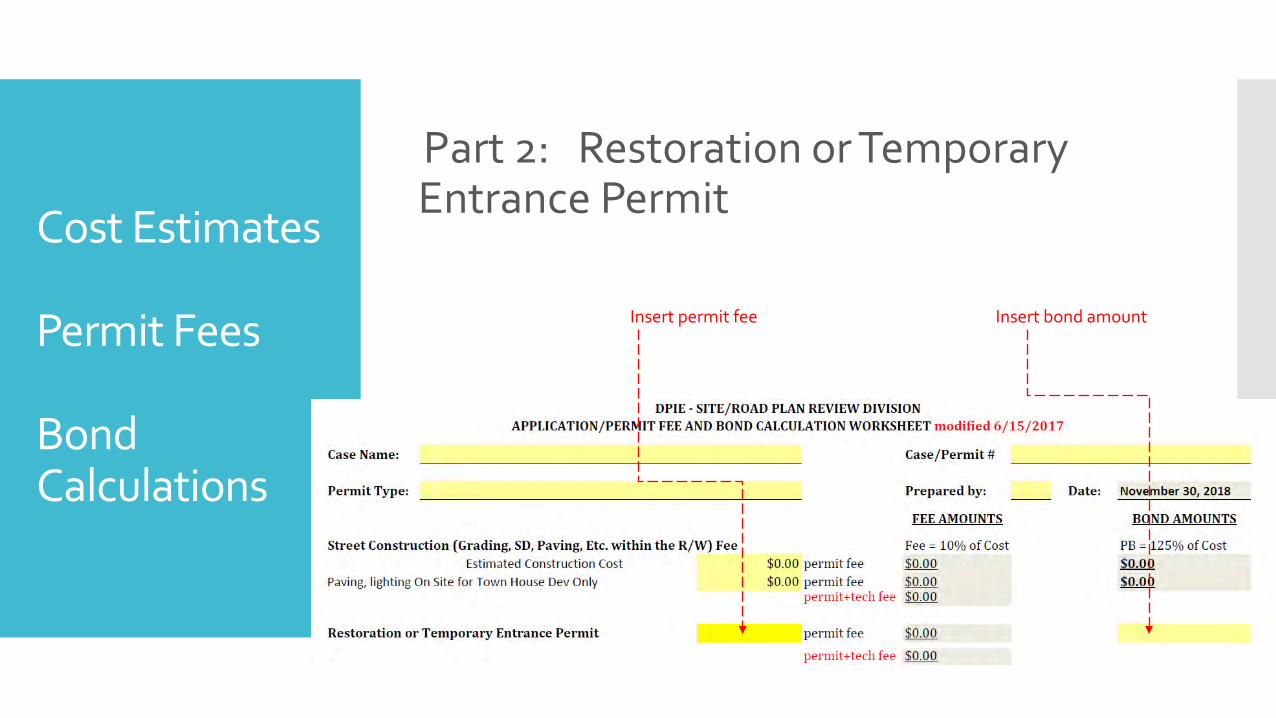
Cost Estimates
Permit Fees
Bond Calculations
Part 2: Restoration or Temporary Entrance PermitIf project involves temporarily accessing a site from the public r/w, and no other bond is in place for this work, include restoration or temporary entrance permit fee and bond. This fee/bond is commonly required for:
Rough Grading Permits
Residential (homeowner) permits for renovations or additions to residential lots
Existing subdivisions where the developer is finished with one permit area, but driving construction equipment over finished streets to gain access to new phase under construction
Permit fees:
$120 residential (per lot) plus 5% technology fee
$300 temporary gravel entrance plus 5% technology fee
$200 commercial (per entrance) plus 5% technology fee
Bonds:
$1500 (one single family lot)
$2500 per entrance (temporary gravel entrance)
$3000 per entrance (commercial entrance)
$30,000 or more (use of existing roads for construction access of new permit area)
Cost Estimates
Permit Fees
Bond Calculations
Part 2: Restoration or Temporary Entrance Permit
Insert permit fee Insert bond amount

Cost Estimates
Permit Fees
Bond Calculations
Part 3: Onsite Grading Cost Estimate1. Determine total disturbed area
2. Determine disturbed area outside of r/w
3. Do not include disturbed area inside r/w
4. Double check that disturbed area matches erosion/sediment control plan
5. Double check that disturbed area in epermits matches cost estimate
6. If grading fee and bond was collected with a prior Rough Grading Permit for the same area, then grading fee and bond is not required, so long as permittee intends on keeping rough grading permit open.
7. Onsite grading fee = $0.008 per SF of disturbed area outside r/w
8. Onsite grading bond = $0.12 per SF of disturbed area outside r/w
Cost Estimates
Permit Fees
Bond Calculations
Part 3: Onsite Grading Cost Estimate1. Determine total disturbed area
2. Determine disturbed area outside of r/w
3. Do not include disturbed area inside r/w
4. Double check that disturbed area matches erosion/sediment control plan
5. Double check that disturbed area in epermits matches cost estimate
6. If grading fee and bond was collected with a prior Rough Grading Permit for the same area, then grading fee and bond is not required with Fine Grading Permit, so long as permittee intends on keeping rough grading permit open for duration of fine grading permit.

Cost Estimates
Permit Fees
Bond Calculations
Part 3: Onsite Grading Fees/Bonds1. PERMIT FEE = $0.008 per SF of disturbed area outside r/w
2. PERFORMANCE BOND = $0.12 per SF of disturbed area outside r/w
3. LABOR/MATERIALMAN BOND LM = None
insert disturbed area outside r/w

Cost Estimates
Permit Fees
Bond Calculations
Part 6: Special Utility Fee and Bond1. PERMIT FEE:
Determine LF of utility under roadway Permit fee = $300 (administrative) Permit fee = $2/LF utility under roadway Permit fee = $0.50/LF utility not under roadway Permit fee = $0.20/LF aerial utility in r/w Permit fee = $10/LF of roadway cut – moratorium roadwaysTotal above fees + 5% technology fee
2. BONDS: CONSTRUCTION COST ESTIMATE – fill in template PERFORMANCE BOND = 125% x construction cost LABOR/MATERIALMAN BOND = 50% x construction cost L/M bond not required if less than $25,000

Cost Estimates
Permit Fees
Bond Calculations
Part 6: Special Utility Fee and Bond
BONDS: CONSTRUCTION COST ESTIMATE FORM

Cost Estimates
Permit Fees
Bond Calculations
Part 6: Special Utility Permit Fee
insert permit fees

Cost Estimates
Permit Fees
Bond Calculations
Part 7: Storm Drain/Stormwater Management Outside R/W1. PUBLIC: Estimate cost of all public storm drain and ESD
outside r/w.
2. PUBLIC: Estimate cost of all public ponds outside r/w.
3. PRIVATE: Estimate cost of all private storm drain and swmoutside r/w.
4. Use county approved unit costs (there are no unit costs for certain items such as bioretention soil, etc)
5. Do include municipal storm drain and SWM – except for City of Bowie.
6. Storm drain and SWM inside public r/w is included in street construction estimate – not in this category

Cost Estimates
Permit Fees
Bond Calculations
Part 7: Storm Drain/Stormwater Management Outside R/W - Fees/Bonds1. PERMIT FEE = 10% of construction cost plus 5% technology fee
2. PERFORMANCE BOND PB = 125% of construction cost (Only for Public)
3. LABOR/MATERIALMAN BOND LM = None insert construction cost private
insert construction cost public

Cost Estimates
Permit Fees
Bond Calculations
Part 8: Stormwater Management Fee in Lieu
RESIDENTIAL FEE
1. $750 per lot if no SWM provided
2. $250 per lot if ESD is provided but 100 year control is not provided
COMMERCIAL/INDUSTRIAL/MIXED USE FEE
1. $16,000 per impervious acre if no SWM provided
2. 1/3 x $16,000 per impervious acre if ESD provided but 100 year control not provided
100 YEAR CONTROL PROJECTS: In some cases, projects that need to provide 100 year control but do not provide pay a fee in lieu equal to the construction cost of the 100 year control facility
Do not add 5% technology fee
CHECK CONCEPT APPROVAL LETTER FOR SWM FEE IN LIEU!

Cost Estimates
Permit Fees
Bond Calculations
Part 8: Stormwater Management Fee in Lieu

Cost Estimates
Permit Fees
Bond Calculations
Part 9: Street Construction Fee in Lieu
In some cases a fee in lieu of frontage road improvements is collected. This must be based on a detailed construction cost estimate for frontage work being waived. Calculate cost same as permit. Add 25% continency. Add engineering 10%, stakeout/geotechnical 10%. This approach much be approved by the Director, with a signed approval letter.Insert approved fee in lieu amount here

Cost Estimates
Permit Fees
Bond Calculations
Part 10: Pond Maintenance Fee
Pond maintenance fee = 10% of construction cost or $10,000 (whichever is greater) per pond. This fee is collected for publicstormwater management ponds. Insert construction cost amount here

Cost Estimates
Permit Fees
Bond Calculations
Part 11: Floodplain Review Fee
If the floodplain review is accomplished in the main case, then add review fees into the bond/fee worksheet
Floodplain Review Fee – collect all that apply below
Floodplain information request $50
Floodplain modeling GIS by county - per tributary $2500 existing OR $3500 existing/proposed
Floodplain study/delineation review $0.50 / LF of stream
Floodplain study/delineation review $200 / structure
Add 5% technology fee

Cost Estimates
Permit Fees
Bond Calculations
Part 12: Tree Preservation Fee
Tree preservation Fee in Lieu or Chesapeake Bay Critical Area Fee in Lieu (also known as woodland conservation fee in lieu OR reforestation fee in lieu) is calculated by MNCPPC Environmental Planning Section
Reforestation Bond or Chesapeake Bay Critical Area Bond is a calculated by MNCPPC Environmental Planning Section
Consult with MNCPPC Environmental Planner for these amounts
Ask District Engineer if fee/bond has already been collected with a previous permit
Insert fee here insert bond here

Cost Estimates
Permit Fees
Bond Calculations
Bond and Fee Worksheet
After completing worksheet, must be reviewed, and approved in writing by District Engineer
Make sure fees and bonds are entered into e-permits with District Engineers assistance
Deliver approved bond/fee worksheet to DPIE Site Road Permits Office (James Coutourier)

Planning Board Conditions
Transportation
Planning Board Conditions Pertaining to Transportation During Site Development Fine Grading Permit review, Peer Reviewer
and District Engineer must require permittee to submit Planning Board conditions (roadway and transportation only) and an analysis that demonstrates compliance. Peer Reviewer and District Engineer to confirm that planning board condition has been met.
Typical Planning Board Condition that requires R/W dedication:
At the time of final plat approval, the applicant shall dedicate the following rights-of-way reflected on the approved preliminary plan of subdivision:
a. A 120-foot right-of-way along A-63, Mattawoman Drive, from north to south through the subject property.
b. A right-of-way of 40 feet from centerline along C-613, MD 381, along the site’s frontage
Peer Reviewer –
Are record plats recorded with the required road r/w dedicated?

Planning Board Conditions
Transportation
Planning Board Conditions Pertaining to Transportation During Site Development Fine Grading Permit review, Peer Reviewer and District
Engineer must require permittee to submit Planning Board conditions (roadway and transportation only) and an analysis that demonstrates compliance. Peer Reviewer and District Engineer to confirm that planning board condition has been met based on the timing triggers.
Typical Planning Board Condition that requires Developer Contribution Towards Offsite Transportation Requirements (Road Club):
Prior to issuance of each building permit, the applicant . . . shall contribute toward …off-site transportation improvements as identified hereinafter. These improvements shall be funded and constructed through the formation of a road club. The applicant’s sole funding responsibility toward construction of these off-site transportation improvements shall be payment of the following:
For each single-family unit, a fee calculated as $1,306 X (Engineering News-Record Highway Construction Cost index at time of payment) / (Engineering News-Record Highway Construction Cost Index for first quarter, 1993).
Peer Reviewer:
have any building permits been issued?
Did those permits pay the developer contribution fee?
Did you provide analysis to MJ Labban for record keeping?

Planning Board Conditions
Transportation
Planning Board Conditions Pertaining to Transportation During Site Development Fine Grading Permit review, Peer Reviewer and
District Engineer must require permittee to submit Planning Board conditions (roadway and transportation only) and an analysis that demonstrates compliance. Peer Reviewer and District Engineer to confirm that planning board condition has been met based on the timing triggers
Typical Planning Board Condition that Requires Construction of Transportation Improvement: Prior to the issuance of any building permits within the subject property, the applicant’s heirs, successors, and/or assignees shall provide a left-turn lane along northbound Cindy Lane per DPW&T standards. This improvement shall (a) have full financial Assurances, (b) have been permitted for construction by DPW&T, and (c) have an agreed-upon timetable for construction with DPW&T.
Peer Reviewer –
have any building permits been issued?
Has permittee filed a separate permit for offsite road improvement – status?
Did you provide analysis to MJ Labban for record keeping?

Plan Review
Private Roads and Alleys
Minimum Width of Private Roads and Alleys
Minimum width of 22’ for private roads and alleys
The 22’ must be clear of any parking.
If less than 22’ is proposed, can only be approved with concurrence letter from fire chief and fire code official.

Plan Review
Mixed Use and Townhouse Projects (High Density)
Mixed Use and Townhouse Projects (High Density)
Private roads and driveways and buildings require detailed grading at time of SDFG permit
NEED TO require engineer to design of streets and infrastructure will work with pending building construction
NEED TO require engineer to demonstrate that all utilities will “fit”

Technograms
Technograms
OLDER TECHNOGRAMS
001-2016 SWM for Redevelopment Sites
002-2016 SWM Grandfathering Pre 2010
003-2016 S/R Construction Cost Estimates for SD & SWM
004-2016 SWM Grandfathering Pre May 2013
005-2016 Basement versus Groundwater Table
007-2016 100 Year Rainfall Intensity *

Technograms
Technograms
NEW TECHNOGRAMS?
001-2018 Residential Driveway Spacing/3 Car Garage DW
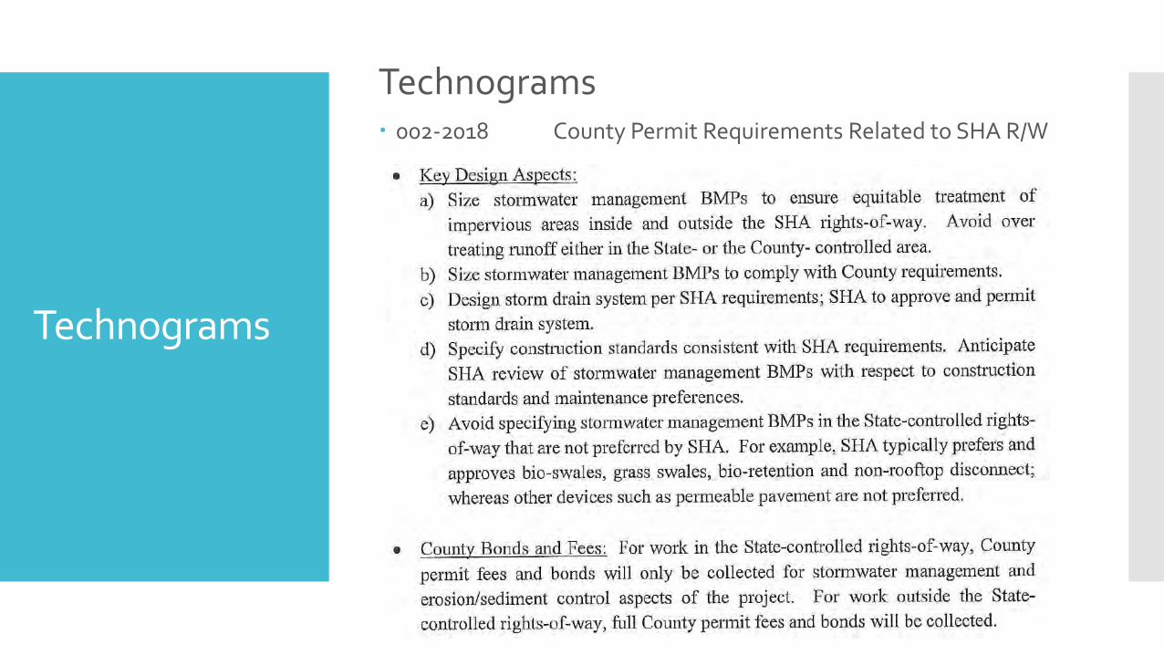
002-2018 County Permit Requirements Related to SHA R/W
004-2018 Geotechnical Requirements for SWM Devices
005-2018 Geotechnical Guidelines Marlboro Clay & OC sites
006-2018 Single Lot As Builts for Residential Lots
007-2018 Floodplain Requirements and Procedures DRAFT
008-2018 Residential Infill Lot Process
009-2018 100 year SWM control maps DRAFT

Technograms
Technograms 002-2018 County Permit Requirements Related to SHA R/W
Technograms
Technograms 002-2018 County Permit Requirements Related to SHA R/W

Technograms
Technograms
004-2018 Geotechnical Requirements for SWM Devices
Offset of soil boring to small scale ESD devices – changed from 30’ to 50’, if ground surface elevation of boring is similar to ESD device.
Drywells – requires geotechnical recommendation – can use boring within 60’ of device (instead of 30’), if ground surface elevation of boring is similar to ESD device.

Technograms
Technograms 005-2018 Geotechnical Guidelines Marlboro Clay & OC sites

Technograms
Technograms 005-2018 Geotechnical Guidelines Marlboro Clay & OC sites

Technograms
Technograms 005-2018
Geotechnical
Guidelines
Marlboro Clay & OC sites

Technograms
Technograms 005-2018 Geotechnical Guidelines Marlboro Clay & OC sites

Technograms
Technograms 005-2018 Geotechnical Guidelines Marlboro Clay & OC sites
Technograms
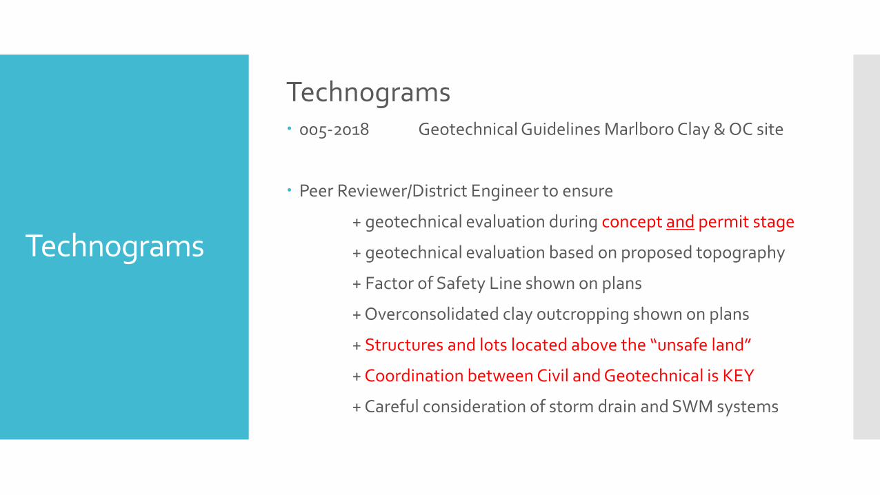
Technograms 005-2018 Geotechnical Guidelines Marlboro Clay & OC site
Peer Reviewer/District Engineer to ensure
+ geotechnical evaluation during concept and permit stage
+ geotechnical evaluation based on proposed topography
+ Factor of Safety Line shown on plans
+ Overconsolidated clay outcropping shown on plans
+ Structures and lots located above the “unsafe land”
+ Coordination between Civil and Geotechnical is KEY
+ Careful consideration of storm drain and SWM systems

Technograms
Technograms
006-2018 Single Lot As Builts for Residential Lots
Engineer to inspect on lot SWM devices and provide checklist and single lot as built prior to completion of house construction - at time of Use/Occupancy Permit
Email single lot as built to DPIE – [email protected]

Technograms
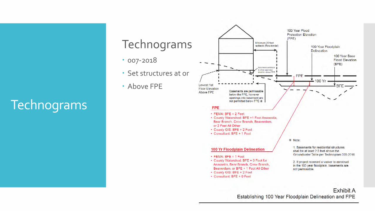
Technograms 007-2018 Floodplain Requirements and Procedures - DRAFT
100 Year Floodplain Delineation
1. Submit floodplain information request – ex studies
2. Prepare new H/H model for any unstudied streams 50 acres or more
3a. Delineate 100 year floodplain based on all FP studies.
3b. Use accurate topography – different datums? Show both datums
4. Secure 100 year FP delineation approval even if previously approved
5. 100 year FP elevation from Hydraulic Model plus freeboard
FEMA add 1’ freeboard County Watershed Study – Add 1’ freeboard - except - add no freeboard for
Anacostia, Bear Branch, Crow Branch, Beaverdam Creek County GIS Study – Add 2’ freeboard Consultant Study – Add no freeboard
Technograms
Technograms 007-2018
Set structures at or
Above FPE
Technograms
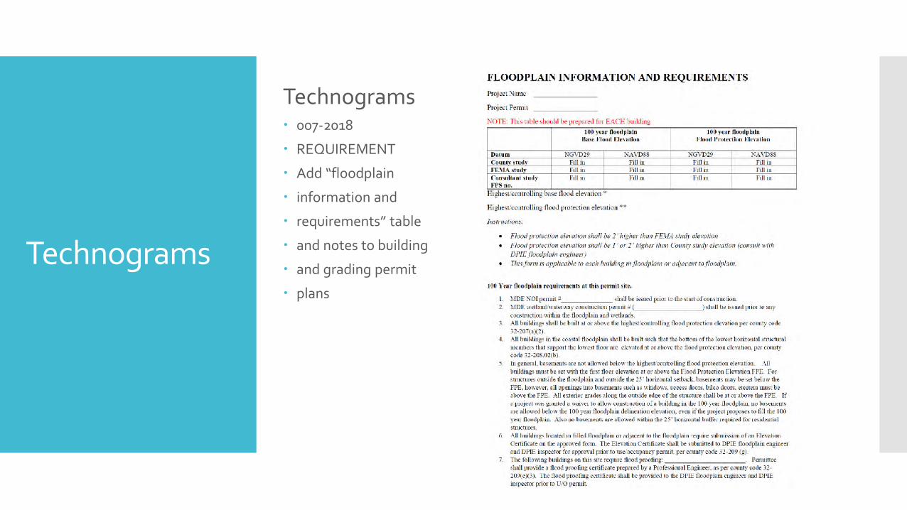
Technograms 007-2018
REQUIREMENT
Add “floodplain
information and
requirements” table
and notes to building
and grading permit
plans

Technograms
Technograms 007-2018
Elevation Certificates
One for FEMA
One for County
Permittee submit Before U/O permit
County FP engineer review/approve

Technograms
Technograms 007-2018
Covenant required If FP waiver was Granted
Covenant must be Recorded before grading and/or Building permit Permit issuance
Technograms
Technograms
008-2018 Residential Infill Lot Process
Streamlined and expedited process for 1 to 6 residential lot projects
Builders must combine all proximate lots into one submission
SWM is not waived if cumulative project is more than 5000 SF of disturbance.
Some 1 lot projects ----- site road concept approval
Others up to 6 lots ----- site road concept/grading permit approval (combined)
Building permit can be processed concurrent with site road concept

Technograms
Technograms
009-2018
100 year
SWM control
maps
DRAFT

QUESTIONS?
COMMENTS?
QUESTIONS?
COMMENTS?