prestwick lower airspace systemisation (plas) airspace ... · pdf fileprestwick lower airspace...
TRANSCRIPT
Prestwick Lower Airspace Systemisation (PLAS) Airspace Development Framework Briefing: Record of Agreement
11th November 2015, CAA House, Kingsway, London Project 4162 4162/RPT/46◊Issue 1.1
Action Position Name Acknowledged Date
Produced Airspace Change
Assurance, O,S
17-Nov-15
Accepted Prestwick Centre, Manager
Terminal Airspace
Development
Approval by email 18-Nov-15
Accepted Case Officer, Controlled
Airspace Section, CAA
SARG
Approval by email 4-Jan-16
CAA (SARG) Attendees:
NATS Attendees:
CAA CC:
NATS CC:
NATS UNCLASSIFIED © 2015 NATS (En-route) plc, (‘NERL’). This document contains commercially confidential
information and must not be disclosed to third parties or copied or reproduced in whole or in part without NERL's prior written consent. All changes to this document shall be authorised by NERL, including its issue, amendment and distribution. In the event that this document is superseded, or no longer required by a designated holder, that holder shall ensure its safe return to NATS.
© 2015 NATS (En-route) plc NATS Unclassified
4162/RPT/46◊Issue 1 Page 2 of 25
Publication history
Issue Month/Year Change Requests in this issue
Issue 1 Nov 2015 First issue released to SARG.
Issue 1.1 Dec 2015 Incorporating comments from CAA Case officer and ERCD.
Contents
1. Introduction ........................................................................................ 3
2. Background ........................................................................................ 3
3. SARG/DFT Design Requirments ............................................................. 4
4. NATS Stakeholder Engagement ............................................................. 5
5. NATS Formal Consultation Plan ............................................................. 5
6. Environmental Analysis ...................................................................... 10
7. Airport Accountability ......................................................................... 10
8. Implementation ................................................................................. 13
9. Requirement for SARG/AD1 Briefing .................................................... 14
10. Clarifications Discussed During the Briefing ........................................ 14
Annex A: Environmental Requirements ..................................................... 15
© 2015 NATS (En-route) plc NATS Unclassified
4162/RPT/46◊Issue 1 Page 3 of 25
1. Introduction
1.1 This note is a record of the framework briefing for the Prestwick Lower Airspace
Systemisation (PLAS) airspace change proposal (ACP). It was agreed that SARG would
assess the proposed airspace change process for the PLAS ACP contained within this
document. Acceptance of this note by SARG will represent an agreement ‘in principle’
that the process undertaken thus far, and the proposed process herein, meets the
requirements of the CAP725 airspace change process.
1.2 The content of this record, and the CAA’s agreement to the proposed content of the ACP
will form part of the evidence required to evaluate whether the project is viable. Hence
it should be stressed that at this stage the decision to proceed with the project
has not been taken. If NATS does intend to proceed a separate “Intention to
Proceed” letter will be submitted to the CAA in due course.
1.3 Should any of the elements of this document change significantly as the plans/processes
develop, NATS will provide the rationale for change to SARG and seek further agreement
in principle for the revisions.
2. Background
2.1 The benefits being sought by the PLAS airspace development are summarised below.
2.2 Safety Benefit:
o All Units: to ensure that the overall ATS provided remains “at least as safe as”
prior to the implementation of this airspace development. The Project will aim to
deliver safety benefits where possible.
o 7% reduction in conflict alerts + overall improvement in safety.
2.3 Capacity Benefit:
o 5% increase overall network airspace capacity to accommodate projected traffic
demand at least to 2025. (Note the expected usable life of the airspace is
expected to be considerably longer, before any further large scale change is
anticipated.)
o Compliance with the Future Airspace Strategy through the provision of PBN routes,
SIDs & STARs which facilitate Continuous Climb Departures and Continuous
Descents, Flexible Use of Airspace (FUA) and simplified boundaries between
controlled and uncontrolled airspace.
o Systemisation to reduce controller/pilot workload.
2.4 Environmental Benefit:
o CO2 saving target of 105,000 tonnes pa.
o Noise mitigation of impact of over-flights below 7000ft.
2.5 Changes in the PLAS region are currently planned to include:
o MTMA re-design – including procedurally deconflicted arrivals and departures for all
airfields.
o Re-designing and upgrading all SIDs and STARs in MTMA to RNAV1.
© 2015 NATS (En-route) plc NATS Unclassified
4162/RPT/46◊Issue 1 Page 4 of 25
o Providing 3nm separation capability below FL285 within required regions.
o Route improvements in ScTMA AOR to provide safety and environmental benefits.
o IOM redesign to improve capacity and reduce complexity.
o Rationalisation of Belfast TMA.
o Release controlled airspace where CCO and CDO allow.
Key messages:
2.6 The following key messages have been identified and will underpin all communications
with regard to this project:
o Safety is always NATS’ first priority. We would never introduce an airspace change
unless we were convinced it was safe to do so.
o NATS is required, under our licence, to provide capacity to meet reasonable growth in
air traffic. Airspace developments are subject to the requirement of the CAA Airspace
Change process (CAP725) which includes consultation with stakeholders.
o Airspace changes are needed to enhance the safety and efficiency of air traffic control
in the face of sustained growth in the aviation industry and to minimise future delays.
o NATS takes environmental considerations very seriously. The PLAS development aims
to utilise procedures for minimising the environmental impact of aviation growth.
3. SARG/DFT Design Requirements
3.1 An outline of the generic design aims as relating to the SARG/DfT requirements that
NATS considers for all ACPs was provided, including those relating specifically to
environmental aspects. These are listed below. Those which can be applied to the PLAS
development are highlighted in bold.
3.2 SARG/DfT design aims:
a) To design routes based on RNAV1.
b) To ensure that designs are consistent with Government policy (e.g. Air
Transport White Paper/Review).
c) Runway development: where applicable accommodate future growth due to
proposed runway expansion projects.
3.3 Environmental design aims:
Where practical, within operational and safety constraints:
a) enable CDAs
b) minimise track mileage
c) allow more efficient flight profiles (i.e. clear climbs/descents on
separated tracks)
d) minimise population over-flown
e) minimise exposure of new populations to noise and visual impacts
f) minimise low level over-flight of AONBs, National Parks and other
tranquil areas
3.4 These aims are aspirational in so much that it may not be possible to achieve all aims
within one design. The final design will hence reflect a balance between competing
© 2015 NATS (En-route) plc NATS Unclassified
4162/RPT/46◊Issue 1 Page 5 of 25
requirements (e.g. avoiding population may only be possible with additional track
mileage). NATS will seek to demonstrate this balanced approach to achieving all the
design aims within the consultation documents and ACP.
4. NATS Stakeholder Engagement
4.1 As part of the design process NATS has been engaging with key aviation stakeholders
(e.g. airlines) through a number of meetings and through simulation participation.
5. NATS Formal Consultation Plan
5.1 Formal consultation for PLAS is planned to commence with a swathe consultation in Q3-
Q4 2016. This may take the form of a single consultation across the PLAS area or
separate regional consultations (potentially staggered in terms of timing).
5.2 Whilst the specific form of the consultation is still being developed, there are generic
elements which are described below.
Consultation Objective
5.3 The purpose of consultation is to attain or confirm views and opinions about the potential
impact of a particular Airspace Change Proposal. NATS will design the airspace in line
with government policy1 unless there is a clear, justified remit across affected
stakeholders to do differently. Consultees therefore have a crucial role in providing
relevant and timely feedback to the Change Sponsor in the form of their views and
opinions on the impact of a particular Airspace Change Proposal.
5.4 In the event of consultation generating a clear and justified remit for a design that does
not meet the government guidance (for example one leading to dispersal rather than
concentration) then NATS will seek confirmation from the CAA that any such deviation is
appropriate before submitting the ACP
5.5 Experience has shown that those that perceive a potential disbenefit are more likely to
respond to consultation than those that would potentially benefit; therefore consultation
response is not a reliable measure of the relative benefit or disbenefit of a proposal.
Hence the aim of consultation is to collect information/requirements to consider in the
on-going design process, rather than being a voting process to determine popularity.
5.6 NATS does not intend to reconsult on impacts covered in the swathe consultation. The
swathe consultation will make this clear by stating that that the feedback received
through the early consultation will be used directly to inform the final options presented
in the ACP without further consultation. Reconsultation on any element of the design
will only occur if the development of the detailed designs leads to a new impact not an
area not captured by the initial consultation. For example this may be a geographical
area outside the corridor consulted on, or a new measurable impact such as a change to
1 Department For Transport, Guidance to the Civil Aviation Authority on Environmental Objectives Relating to the
Exercise of its Air Navigation Functions (Jan 2014)
© 2015 NATS (En-route) plc NATS Unclassified
4162/RPT/46◊Issue 1 Page 6 of 25
Leq or SEL. (Note however that the NATS designs are focussed on airspace above 4000ft
therefore impacts to Leq and SEL are not expected.
Stakeholder Identification for Formal Consultation
5.7 The formal consultation exercise is proposed to include distribution by email of
consultation material to the following stakeholder groups.
Under the proposed airspace, subject to change below FL195:
a) All AONBs/National Parks.
b) District & Borough councils who have an AONB within their district.
c) MPs, MSPs (where applicable), MEPs
d) NATMAC.
Where proposed changes are below 7000ft agl, the above plus:
e) All affected County, District, Borough Councils and unitary authorities
f) Airport Operators and consultative committees for all affected airports
g) National Environmental bodies (Countryside Agency, English Heritage, NSCA,
National Trust, CPRE etc).
h) Airlines operating from the Group 1 & 2 airfields
Airports will be responsible for design & consultation of changes to lower altitude route
structures. These will include all routes below 4,000ft, but the exact design interface
points (which will also dictate the limits of consultation responsibility taken by the
airport) will be agreed between NATS and each individual airport. These transfer points
may be above 4,000ft dependent on local environmental and design requirements.
Consultation briefings
5.8 Individual briefings will be offered to the following groups:
All affected County Councils and unitary authorities.
All affected MPs.
EGPH Airport Consultative Committee (ACC).
Airlines/NATMAC/Military
5.9 Collective briefings will be offered to District & Borough Council representatives beneath
hotspot areas, i.e. potentially noticeable changes such as holds, transitions and SIDs
flown below 7000ft.
5.10 Briefings will not be offered to:
District, Borough Councils beneath STARs, SIDs only flown in radio fail situations, or
routes changing to follow existing swathes.
Other special interest groups (e.g. national bodies or pressure groups focusing on
single issues).
Members of the public.
5.11 NATS has not been advised of any additional stakeholder groups that have registered an
interest in this airspace change directly to the CAA. Hence if there are any such groups
the CAA should notify NATS of their details.
© 2015 NATS (En-route) plc NATS Unclassified
4162/RPT/46◊Issue 1 Page 7 of 25
Consultation Documents
5.12 The consultation materials will consist of a hierarchy of materials as follows
Top tier – Summary information aimed at providing information on:
Am I affected, and if so, am I interested?
To include press release, media launch, website with clickable map, executive
summaries on web with documentation.
Middle tier – Main consultation document set aimed at providing information on:
How might it affect me, my community, my business?
Do I have any relevant information to feed back?
To include justification, swathe maps, environmental analysis results, aviation
maps, FAQs.
Third tier – Technical documents aimed at providing information on how we came to our
conclusions:
To include environmental analysis reports, tables of options considered, technical
FAQs. These will be in technical language presented for specialists rather than
the layman.
5.13 The consultation material will be published via dedicated web pages.
5.14 The ‘swathe’ maps for local stakeholders will show the widest potential spread and worst-
case heights for the potential route alignments that would fit the proposed concept2.
Height, traffic numbers and noise information, will be provided to allow stakeholders to
determine the potential effect on the area of interest. The following text will be provided
as guidance for the laymen to interpret the maps.
“The noise and visual impact experienced at a given location will depend on where the
route is positioned within the consultation swathe; high concentrations of traffic would be
directly overhead only a small proportion of the overall area. We are asking you to
consider that the routes in question could be positioned anywhere within the consultation
swathe, and to be mindful therefore that anywhere within the consultation swathe has
the potential for noise and visual impact.”
Information on the scale of potential impact will be presented alongside or within the
maps, describing:
The potential number of aircraft that would fly on the route and which may be
overhead subject to the final route position within the consultation swathe
2 The ‘widest potential spread’ and ‘worst case height’ is used here in the context of standard operations. Track plots
will occasionally show flights following unpredictable paths due to unusual circumstances such as avoiding action or
weather avoidance. The potential for aircraft to follow unusual tracks is inherently unpredictable. Furthermore, the
possibility of aircraft following such unpredictable tracks exists today and would remain unchanged as the result of the
proposal, and so is not a ‘change’ that we are consulting on.
© 2015 NATS (En-route) plc NATS Unclassified
4162/RPT/46◊Issue 1 Page 8 of 25
The altitude of these aircraft
A measurement of how loud aircraft at that height would sound at ground level (a
metric referred to as Lmax)
With this information stakeholders can identify whether the potential impact is significant
(i.e. the potential number of aircraft overhead, and the resultant noise and visual
intrusion).
5.15 The website and consultation document will include a comprehensive set of questions &
answers to frequently asked questions. Where new, relevant, questions arise during the
consultation period these will be added to the FAQs.
5.16 The consultation document will be produced in English only.
5.17 SARG will be requested to review and comment on the consultation material prior to
publication.
5.18 It is important to ensure that stakeholders are aware of the scope of the consultation, so
that the feedback provided has the maximum possibility of affecting the final design. This
necessarily involves highlighting issues that will be beyond the scope of the consultation,
such as:
a) Government policy (e.g. tranquillity versus population, targets to reducing CO2).
b) CAA Policy (e.g. use of P-RNAV, design guidance)
c) Traffic growth (e.g. whether continued growth is good or the effect of the recent
downturn).
d) Airport expansion/Air Transport White Paper.
e) Runway alternation.
f) Analysis methodologies (we are not consulting on the appropriateness of analysis
techniques or models, e.g. ANCON noise modelling system).3
Consultation Response Management
5.19 The feedback channels for consultees will be as follows:
Web based questionnaire with free text entry.
Postal address to be provided for postal response.
5.20 All responses will be logged in a database and categorised according to ‘theme’.
Consultation responses will be analysed and new information contained within responses
will be logged.
5.21 Once the consultation period has closed, a feedback document will be published. The
feedback document will give statistical analysis of the responses and summarise all the
themes and the NATS’s response to any issues raised. The feedback document will be
available for download via the NATS website. Any new requirements identified will be
considered in the on-going design process. A second design report will be published prior
to ACP submission, detailing the design being submitted and making reference to
changes that have been made to take account of consultation feedback.
3 CAP725 states that a submitted ACP must not contain “any aspects” that have not been consulted upon. “ Any
aspects” in this sense is to be interpreted as meaning there should be no aspects of the proposed designs in the ACP
that have not been consulted upon, i.e. all changing routes, holds and CAS in the ACP must have been consulted upon.
© 2015 NATS (En-route) plc NATS Unclassified
4162/RPT/46◊Issue 1 Page 9 of 25
5.22 All responses to the consultation exercise will be provided to SARG in full as part of the
ACP documentation set, except where the repondee requests anonymity in which their
personal details will be removed.
Consultation Response Management
5.23 The feedback channels for consultees will be as follows:
Web based questionnaire with free text entry.
Postal address to be provided for postal response.
5.24 All responses will be logged in a database and categorised according to ‘theme’.
Consultation responses will be analysed and new information contained within responses
will be logged.
5.25 Once the consultation period has closed, a feedback document will be published. The
feedback document will give statistical analysis of the responses and summarise all the
themes and the NATS response to any issues raised. The feedback document will be
available for download via the NATS website. Any new requirements identified will be
considered in the on-going design process. A second design report will be published prior
to ACP submission, detailing the design being submitted and making reference to
changes that have been made to take account of consultation feedback.
5.26 All responses to the consultation exercise will be provided to SARG in full as part of the
ACP documentation set, except where the repondee requests anonymity in which their
personal details will be removed.
NATS acknowledgement & replies
5.27 NATS will use the following guidelines for acknowledgement and replies to questions
raised by consultees during the consultation:
a) Online responses to the consultation will be automatically acknowledged.
b) Postal respondents will not be acknowledged.
c) Where we consider that additional information is necessary for respondents to
provide their representations, whether identified through a question from a consultee
or comes to our attention through other channels, we will publish the additional
information in the FAQs section of the consultation website, so that the information is
available to everyone. Potentially affected stakeholders will be notified if additional
information is published including, if applicable, any consultee that identified the
need for additional information in their response.
Late Reponses
5.28 Late responses will be logged and stored but not analysed. In individual cases NATS may
consider there to be sufficient justification to accept and respond to late feedback,
however this will be at NATS’ discretion.
a) Responses considered ‘late’ will be:
Any response where the respondent had dated the letter after end of consultation,
or
Any postal response received more than 7 days after the end of the consultation.
b) The web response facility will be closed at the end of the consultation.
© 2015 NATS (En-route) plc NATS Unclassified
4162/RPT/46◊Issue 1 Page 10 of 25
5.29 It is important to ensure that stakeholders are aware of the scope of the consultation, so
that the feedback provided has the maximum possibility of affecting the final design. This
necessarily involves highlighting issues that will be beyond the scope of the consultation,
such as:
Government policy (e.g. tranquillity versus population, targets to reducing CO2).
CAA Policy (e.g. use of PBN, design guidance)
Traffic growth (e.g. whether continued growth is good).
Airport expansion/Air Transport White Paper.
Runway alternation.
Analysis methodologies (we are not consulting on the appropriateness of analysis
techniques or models, e.g. ANCON noise modelling system).4
6. Environmental Analysis
6.1 An overview of the proposed environmental analysis for PLAS was presented.
Information to enable an assessment of the environmental impact of the change will be
presented in the consultation documents and ACP. In order to enable stakeholders to
establish the potential impact of the changes on their area, this information will include:
a) Maps showing the swathes of airspace within which aircraft following new
procedures may be seen.
b) Forecast traffic data for the proposed airspace.
c) Emissions analysis. (An emissions and fuel burn comparison will be undertaken for
an illustrative set of tracks for each major traffic flow before and after the change.
However, as this is a swathe consultation the final position of the tacks is not
known, therefore results will be expressed as a range around the calculated
difference to account of the uncertainty in the final route positioning. A system-
wide assessment of the emissions and fuel burn for traffic using the existing and
proposed airspace will also be provided; this will also express the result as a
range.)
d) Noise analysis as detailed in the Annex A tables below.
Note that a detailed list of the environmental requirements and the NATS proposal for
fulfilling them is provided at Annex A.
6.2 It was agreed that local air quality analysis is not likely to be required for the Edinburgh
ACP project. 1,000ft agl is accepted by the SARG as the limit of the mixing height for
emissions, therefore changes to flight profiles above this height are unlikely to have any
significant affect on Local Air Quality (LAQ) on the ground (note that the Dft guidance
states that LAQ is not an issue for airspace change unless the changes are below
1000ft). For this reason, since the PLAS project does not anticipate changing any flight
profiles below 1,000ft agl it was agreed that no assessment of LAQ is required.
4 CAP725 states that a submitted ACP must not contain “any aspects” that have not been consulted upon. “ Any
aspects” in this sense is to be interpreted as meaning there should be no aspects of the proposed designs in the ACP
that have not been consulted upon, i.e. all changing routes, holds and CAS in the ACP must have been consulted upon.
© 2015 NATS (En-route) plc NATS Unclassified
4162/RPT/46◊Issue 1 Page 11 of 25
7. Airport Accountability
7.1 In order to feed traffic into PLAS, the airports will need to update their existing routes to
be compliant with modern Performance Based Navigation (PBN) standards. As a
minimum, this requires replication of the existing route structures with RNAV1
replications.
7.2 Airports may also seek to utilise the greater flexibility in design afforded by PBN to
progress a more fundamental redesign of routes rather than just pursue replication. The
objectives for such local changes could be to address local airport capacity, and/or low
level noise issues. Airports would be responsible for their own local development,
analysis and consultation.
7.3 Airport led SID developments will follow the process for SID change agreed through FAS
(see Figure 1).
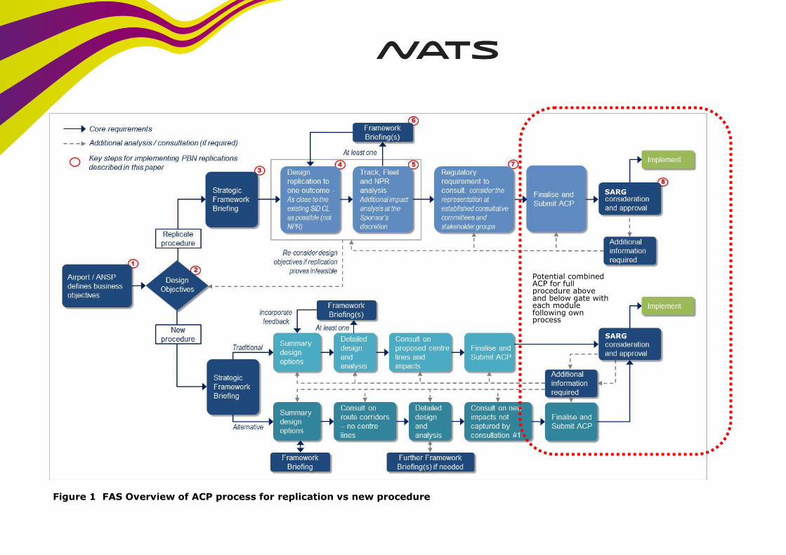
Potential combined ACP for full procedure above and below gate with each module following own process
Figure 1 FAS Overview of ACP process for replication vs new procedure
SARG
SARG
7.4 Wherever possible airport intentions for low level changes are being developed to be
independent of PLAS (ie low level changes could knit into either the existing or future
network). This is may not be possible in all cases however.
7.5 Whilst a degree of independence is possible in the early stages it may be necessary for
PLAS and airports to have a more collaborative approach during the detailed design stage
as procedure design, flyability and safety assurance must be undertaken on a complete
route rather than considering segments above and below gates separately. This will be
determined on a case by case basis and feed into a modular ACP as described below.
8. Modular ACP Format
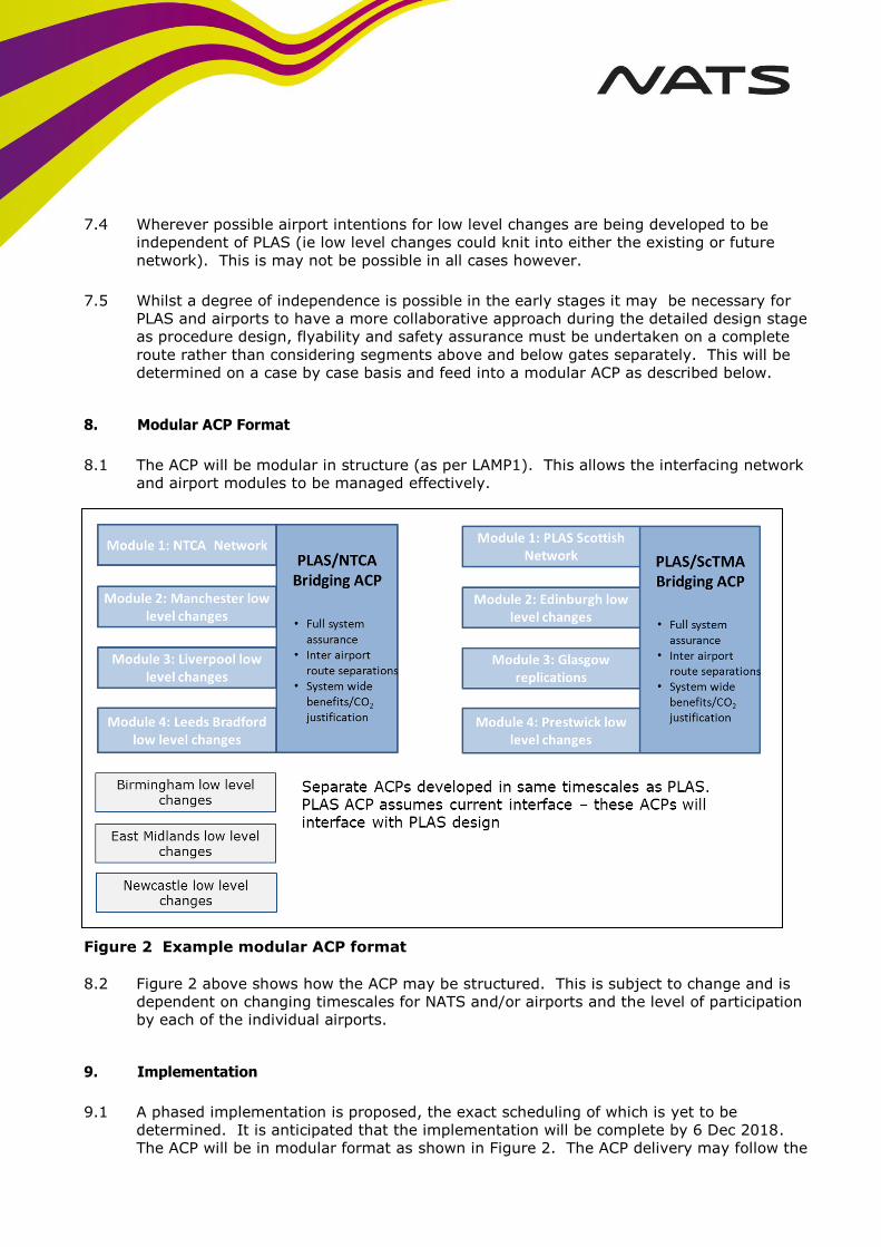
8.1 The ACP will be modular in structure (as per LAMP1). This allows the interfacing network
and airport modules to be managed effectively.
Figure 2 Example modular ACP format
8.2 Figure 2 above shows how the ACP may be structured. This is subject to change and is
dependent on changing timescales for NATS and/or airports and the level of participation
by each of the individual airports.
9. Implementation
9.1 A phased implementation is proposed, the exact scheduling of which is yet to be
determined. It is anticipated that the implementation will be complete by 6 Dec 2018.
The ACP will be in modular format as shown in Figure 2. The ACP delivery may follow the
© 2015 NATS (En-route) plc NATS Unclassified
4162/RPT/46◊Issue 1 Page 14 of 25
“adaptive process” (as agreed between NATS and CAA) with the Bridging ACP and
Network modules being delivered initially and the CAA evaluating these modules in
advance of the others.
10. MoD Briefing
10.1 An initial brief to MoD DAATM SO1/SO2 was given on 11th and 27th of November.
11. Clarifications Discussed During the Briefing
11.1 The possibility of Blackpool airport re-opening was discussed. This is not currently
anticipated in the design but it could be accommodated if this transpires. NATS routinely
has to adapt to changes in airline operations (including new routes from regional
airports) at relatively short notice.
11.2 The designs shown for five parallel routes in the IOM sector are currently spaced at 5nm.
The CAA route spacing guidance (currently in draft) states that given adequate
navigation and surveillance coverage etc routes can be spaced at 4.2nm. It is proposed
that this route structure could be introduced on a trial basis. This could be used to
validate the route spacing for the airspace & traffic mix in question and provide evidence
to support the case for 3nm radar separation within the AOR (up to FL285).
11.3 Manchester Airport is required by the Eurocontrol SES PCP to mandate RNP1 by January
2024.
11.4 The requirement for an RNAV1 mandate in the airspace was discussed (for example
RNAV1 mandate FL100 & above). The CAA expressed that it would support such a
mandate if it were deemed necessary. This will be explored as an option.
11.5 The current designs as presented have been tested with the existing Transition Altitudes
of 5000ft/6000ft across the region, and 18,000ft. The project is progressing on the basis
of the extant TA. Introduction of a different TA, such as 6000ft would have an impact on
the designs and would require some rework. This would be subject to a change request
and an impact assessment.
11.6 NATS are aware that there is an on-going DfT review of guidance to the CAA; changes to
this guidance could impact the process during the life of the project
11.7 A review of the CAA Airspace Change Process (CAP725) is also underway and changes
could impact the process during the life of the project.
CAP 725 – Environmental Assessment Checklist
© 2015 NATS (En-route) plc NATS Unclassified
4162/RPT/46◊Issue 1 Page 15 of 25
Annex A: Environmental Requirements
This section details the proposal to fulfil the required elements of an Environmental Assessment to be submitted for the PLAS airspace
development based upon CAP 725 – Appendix B (30 March 2007).
The requirements in this section are grouped by the degree of compliance expected from airspace change sponsors in following this
guidance:
1. Must – change sponsors are to meet the requirements in full when this term is used.
2. Should – change sponsors are to meet these requirements unless there is sufficient reason which must be agreed in writing with the SARG case officer and the circumstances recorded in the formal airspace change documentation.
3. May – change sponsors decide whether this guidance is appropriate to the circumstances of the airspace change.
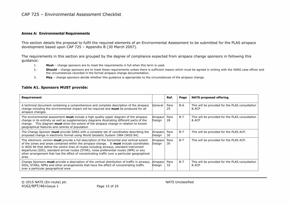
Table A1. Sponsors MUST provide:
Requirement Ref. Page NATS proposed offering
A technical document containing a comprehensive and complete description of the airspace
change including the environmental impact will be required and must be produced for all airspace changes.
General Para 25
B-6 This will be provided for the PLAS consultation & ACP
The environmental assessment must include a high quality paper diagram of the airspace change in its entirety as well as supplementary diagrams illustrating different parts of the change. This diagram must show the extent of the airspace change in relation to known geographical features and centres of population
Airspace Design
Para 28
B-7 This will be provided for the PLAS consultation & ACP
The Change Sponsor must provide SARG with a complete set of coordinates describing the proposed change in electronic format using World Geodetic System 1984 (WGS 84).
Airspace Design
Para 30
B-7 This will be provided for the PLAS ACP.
This electronic version must provide a full description of the horizontal and vertical extent
of the zones and areas contained within the airspace change. It must include coordinates in WGS 84 that define the centre lines of routes including airways, standard instrument departures (SID), standard arrival routes (STAR), noise preferential routes (NPR) or any other arrangement that has the effect of concentrating traffic over a particular geographical area.
Airspace Design
Para 30
B-7 This will be provided for the PLAS ACP.
Change Sponsors must provide a description of the vertical distribution of traffic in airways, SIDs, STARs, NPRs and other arrangements that have the effect of concentrating traffic over a particular geographical area
Airspace Design
Para 32
B-7 This will be provided for the PLAS consultation & ACP
CAP 725 – Environmental Assessment Checklist
© 2015 NATS (En-route) plc NATS Unclassified
4162/RPT/46◊Issue 1 Page 16 of 25
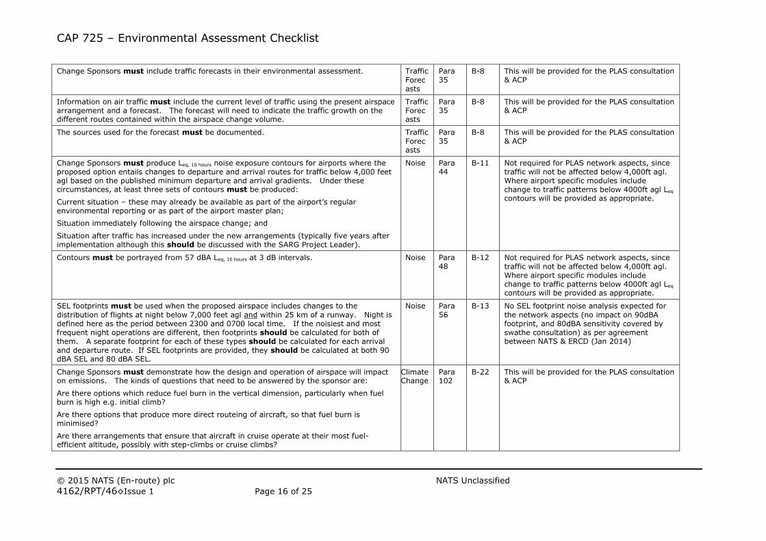
Change Sponsors must include traffic forecasts in their environmental assessment. Traffic
Forecasts
Para 35
B-8 This will be provided for the PLAS consultation & ACP
Information on air traffic must include the current level of traffic using the present airspace arrangement and a forecast. The forecast will need to indicate the traffic growth on the different routes contained within the airspace change volume.
Traffic Forecasts
Para 35
B-8 This will be provided for the PLAS consultation & ACP
The sources used for the forecast must be documented. Traffic
Forecasts
Para 35
B-8 This will be provided for the PLAS consultation & ACP
Change Sponsors must produce Leq, 16 hours noise exposure contours for airports where the proposed option entails changes to departure and arrival routes for traffic below 4,000 feet agl based on the published minimum departure and arrival gradients. Under these circumstances, at least three sets of contours must be produced:
Current situation – these may already be available as part of the airport’s regular environmental reporting or as part of the airport master plan;
Situation immediately following the airspace change; and
Situation after traffic has increased under the new arrangements (typically five years after implementation although this should be discussed with the SARG Project Leader).
Noise Para 44
B-11 Not required for PLAS network aspects, since traffic will not be affected below 4,000ft agl. Where airport specific modules include change to traffic patterns below 4000ft agl Leq contours will be provided as appropriate.
Contours must be portrayed from 57 dBA Leq, 16 hours at 3 dB intervals. Noise Para 48
B-12 Not required for PLAS network aspects, since
traffic will not be affected below 4,000ft agl. Where airport specific modules include change to traffic patterns below 4000ft agl Leq contours will be provided as appropriate.
SEL footprints must be used when the proposed airspace includes changes to the
distribution of flights at night below 7,000 feet agl and within 25 km of a runway. Night is defined here as the period between 2300 and 0700 local time. If the noisiest and most frequent night operations are different, then footprints should be calculated for both of them. A separate footprint for each of these types should be calculated for each arrival and departure route. If SEL footprints are provided, they should be calculated at both 90 dBA SEL and 80 dBA SEL.
Noise Para 56
B-13 No SEL footprint noise analysis expected for
the network aspects (no impact on 90dBA footprint, and 80dBA sensitivity covered by swathe consultation) as per agreement between NATS & ERCD (Jan 2014)
Change Sponsors must demonstrate how the design and operation of airspace will impact on emissions. The kinds of questions that need to be answered by the sponsor are:
Are there options which reduce fuel burn in the vertical dimension, particularly when fuel burn is high e.g. initial climb?
Are there options that produce more direct routeing of aircraft, so that fuel burn is minimised?
Are there arrangements that ensure that aircraft in cruise operate at their most fuel-efficient altitude, possibly with step-climbs or cruise climbs?
Climate Change
Para 102
B-22 This will be provided for the PLAS consultation & ACP
CAP 725 – Environmental Assessment Checklist
© 2015 NATS (En-route) plc NATS Unclassified
4162/RPT/46◊Issue 1 Page 17 of 25
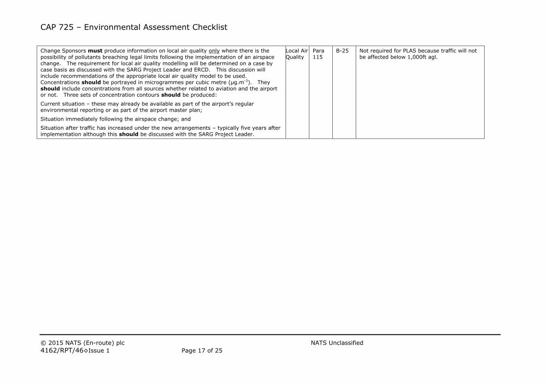
Change Sponsors must produce information on local air quality only where there is the
possibility of pollutants breaching legal limits following the implementation of an airspace change. The requirement for local air quality modelling will be determined on a case by case basis as discussed with the SARG Project Leader and ERCD. This discussion will include recommendations of the appropriate local air quality model to be used. Concentrations should be portrayed in microgrammes per cubic metre (μg.m-3). They should include concentrations from all sources whether related to aviation and the airport or not. Three sets of concentration contours should be produced:
Current situation – these may already be available as part of the airport’s regular environmental reporting or as part of the airport master plan;
Situation immediately following the airspace change; and
Situation after traffic has increased under the new arrangements – typically five years after implementation although this should be discussed with the SARG Project Leader.
Local Air Quality
Para 115
B-25 Not required for PLAS because traffic will not be affected below 1,000ft agl.
CAP 725 – Environmental Assessment Checklist
© 2015 NATS (En-route) plc NATS Unclassified
4162/RPT/46◊Issue 1 Page 18 of 25
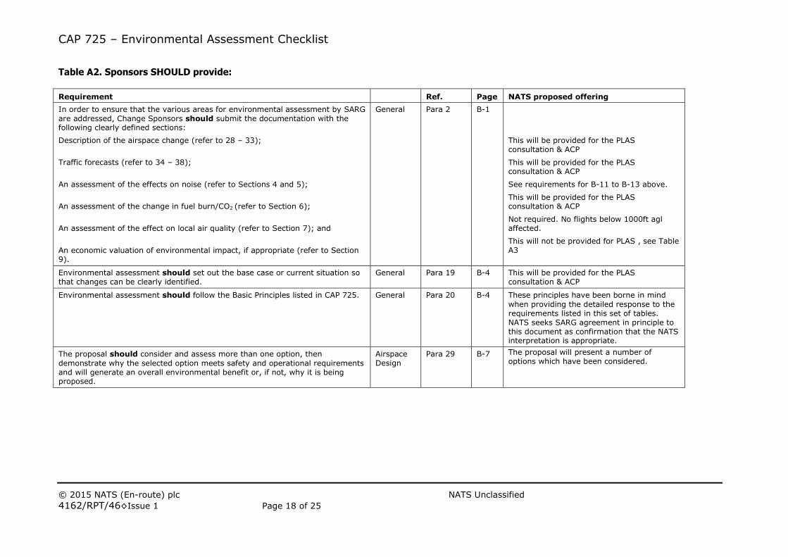
Table A2. Sponsors SHOULD provide:
Requirement Ref. Page NATS proposed offering
In order to ensure that the various areas for environmental assessment by SARG
are addressed, Change Sponsors should submit the documentation with the following clearly defined sections:
Description of the airspace change (refer to 28 – 33);
Traffic forecasts (refer to 34 – 38);
An assessment of the effects on noise (refer to Sections 4 and 5);
An assessment of the change in fuel burn/CO2 (refer to Section 6);
An assessment of the effect on local air quality (refer to Section 7); and
An economic valuation of environmental impact, if appropriate (refer to Section 9).
General Para 2 B-1
This will be provided for the PLAS consultation & ACP
This will be provided for the PLAS consultation & ACP
See requirements for B-11 to B-13 above.
This will be provided for the PLAS consultation & ACP
Not required. No flights below 1000ft agl affected.
This will not be provided for PLAS , see Table A3
Environmental assessment should set out the base case or current situation so that changes can be clearly identified.
General Para 19 B-4 This will be provided for the PLAS consultation & ACP
Environmental assessment should follow the Basic Principles listed in CAP 725. General Para 20 B-4 These principles have been borne in mind
when providing the detailed response to the requirements listed in this set of tables. NATS seeks SARG agreement in principle to this document as confirmation that the NATS interpretation is appropriate.
The proposal should consider and assess more than one option, then
demonstrate why the selected option meets safety and operational requirements and will generate an overall environmental benefit or, if not, why it is being proposed.
Airspace Design
Para 29 B-7 The proposal will present a number of options which have been considered.
CAP 725 – Environmental Assessment Checklist
© 2015 NATS (En-route) plc NATS Unclassified
4162/RPT/46◊Issue 1 Page 19 of 25
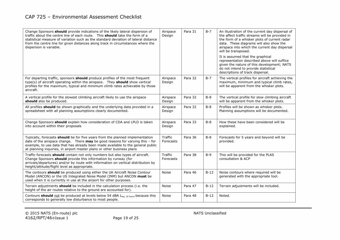
Change Sponsors should provide indications of the likely lateral dispersion of
traffic about the centre line of each route. This should take the form of a statistical measure of variation such as the standard deviation of lateral distance from the centre line for given distances along track in circumstances where the dispersion is variable.
Airspace Design
Para 31 B-7 An illustration of the current day dispersal of
the affect traffic streams will be provided in the form of a whisker plots of current radar data. These diagrams will also show the airspace into which the current day dispersal will be transposed.
It is assumed that the graphical
representation described above will suffice given the nature of this development; NATS do not intend to provide statistical descriptions of track dispersal.
For departing traffic, sponsors should produce profiles of the most frequent
type(s) of aircraft operating within the airspace. They should show vertical profiles for the maximum, typical and minimum climb rates achievable by those aircraft.
Airspace Design
Para 32 B-7 The vertical profiles for aircraft achieving the
maximum, minimum and typical climb rates, will be apparent from the whisker plots.
A vertical profile for the slowest climbing aircraft likely to use the airspace should also be produced.
Airspace Design
Para 32 B-8 The vertical profile for slow climbing aircraft will be apparent from the whisker plots.
All profiles should be shown graphically and the underlying data provided in a spreadsheet with all planning assumptions clearly documented.
Airspace Design
Para 32 B-8 Profiles will be shown as whisker plots. Planning assumptions will be documented.
Change Sponsors should explain how consideration of CDA and LPLD is taken into account within their proposals
Airspace Design
Para 33 B-8 How these have been considered will be explained.
Typically, forecasts should be for five years from the planned implementation
date of the airspace change. There may be good reasons for varying this – for example, to use data that has already been made available to the general public at planning inquiries, in airport master plans or other business plans
Traffic Forecasts
Para 36 B-8 Forecasts for 5 years and beyond will be provided.
Traffic forecasts should contain not only numbers but also types of aircraft.
Change Sponsors should provide this information by runway (for arrivals/departures) and/or by route with information on vertical distribution by height/altitude/flight level as appropriate.
Traffic Forecasts
Para 38 B-9 This will be provided for the PLAS consultation & ACP
The contours should be produced using either the UK Aircraft Noise Contour Model (ANCON) or the US Integrated Noise Model (INM) but ANCON must be used when it is currently in use at the airport for other purposes.
Noise Para 46 B-12 Noise contours where required will be generated with the appropriate tool.
Terrain adjustments should be included in the calculation process (i.e. the height of the air routes relative to the ground are accounted for).
Noise Para 47 B-12 Terrain adjustments will be included.
Contours should not be produced at levels below 54 dBA Leq, 16 hours because this corresponds to generally low disturbance to most people.
Noise Para 48 B-12 Noted.
CAP 725 – Environmental Assessment Checklist
© 2015 NATS (En-route) plc NATS Unclassified
4162/RPT/46◊Issue 1 Page 20 of 25
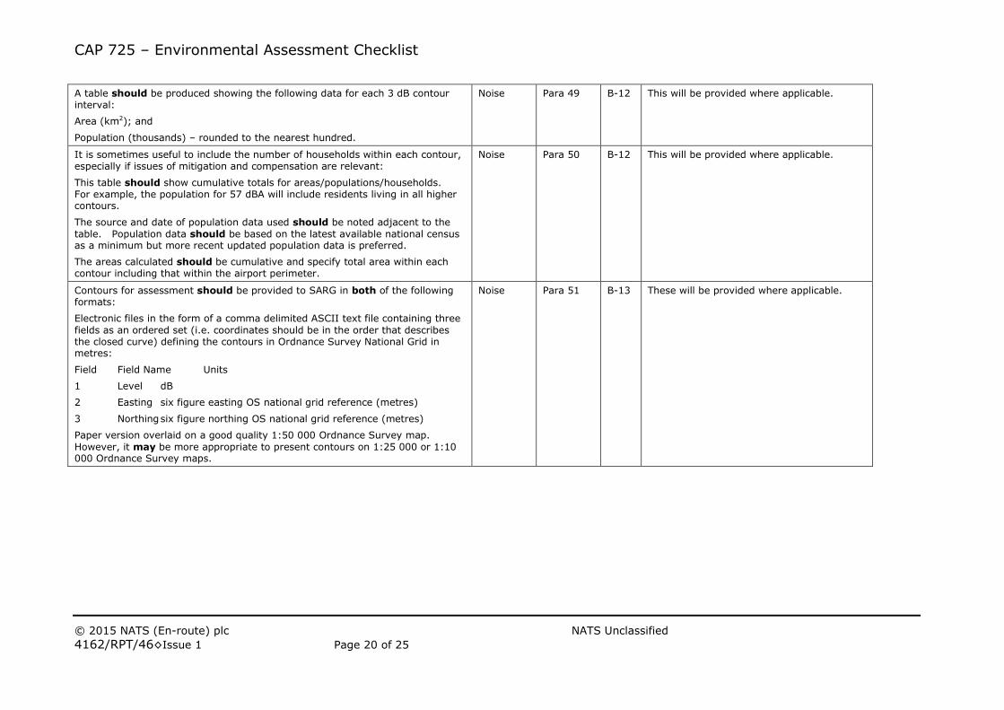
A table should be produced showing the following data for each 3 dB contour interval:
Area (km2); and
Population (thousands) – rounded to the nearest hundred.
Noise Para 49 B-12 This will be provided where applicable.
It is sometimes useful to include the number of households within each contour, especially if issues of mitigation and compensation are relevant:
This table should show cumulative totals for areas/populations/households. For example, the population for 57 dBA will include residents living in all higher contours.
The source and date of population data used should be noted adjacent to the
table. Population data should be based on the latest available national census as a minimum but more recent updated population data is preferred.
The areas calculated should be cumulative and specify total area within each contour including that within the airport perimeter.
Noise Para 50 B-12 This will be provided where applicable.
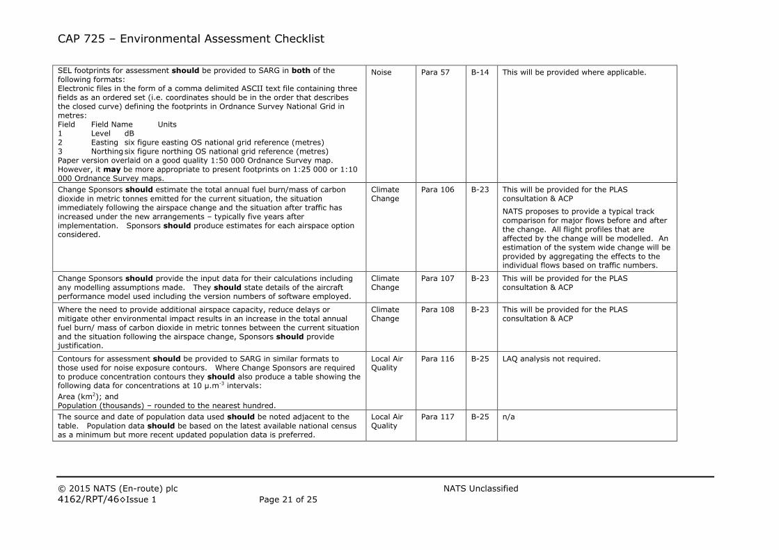
Contours for assessment should be provided to SARG in both of the following formats:
Electronic files in the form of a comma delimited ASCII text file containing three
fields as an ordered set (i.e. coordinates should be in the order that describes the closed curve) defining the contours in Ordnance Survey National Grid in metres:
Field Field Name Units
1 Level dB
2 Easting six figure easting OS national grid reference (metres)
3 Northing six figure northing OS national grid reference (metres)
Paper version overlaid on a good quality 1:50 000 Ordnance Survey map.
However, it may be more appropriate to present contours on 1:25 000 or 1:10 000 Ordnance Survey maps.
Noise Para 51 B-13 These will be provided where applicable.
CAP 725 – Environmental Assessment Checklist
© 2015 NATS (En-route) plc NATS Unclassified
4162/RPT/46◊Issue 1 Page 21 of 25
SEL footprints for assessment should be provided to SARG in both of the following formats: Electronic files in the form of a comma delimited ASCII text file containing three fields as an ordered set (i.e. coordinates should be in the order that describes the closed curve) defining the footprints in Ordnance Survey National Grid in metres: Field Field Name Units 1 Level dB 2 Easting six figure easting OS national grid reference (metres) 3 Northing six figure northing OS national grid reference (metres) Paper version overlaid on a good quality 1:50 000 Ordnance Survey map. However, it may be more appropriate to present footprints on 1:25 000 or 1:10 000 Ordnance Survey maps.
Noise Para 57 B-14 This will be provided where applicable.
Change Sponsors should estimate the total annual fuel burn/mass of carbon
dioxide in metric tonnes emitted for the current situation, the situation immediately following the airspace change and the situation after traffic has increased under the new arrangements – typically five years after implementation. Sponsors should produce estimates for each airspace option considered.
Climate Change
Para 106 B-23 This will be provided for the PLAS consultation & ACP
NATS proposes to provide a typical track
comparison for major flows before and after the change. All flight profiles that are affected by the change will be modelled. An estimation of the system wide change will be provided by aggregating the effects to the individual flows based on traffic numbers.
Change Sponsors should provide the input data for their calculations including
any modelling assumptions made. They should state details of the aircraft performance model used including the version numbers of software employed.
Climate Change
Para 107 B-23 This will be provided for the PLAS consultation & ACP
Where the need to provide additional airspace capacity, reduce delays or
mitigate other environmental impact results in an increase in the total annual fuel burn/ mass of carbon dioxide in metric tonnes between the current situation and the situation following the airspace change, Sponsors should provide justification.
Climate Change
Para 108 B-23 This will be provided for the PLAS consultation & ACP
Contours for assessment should be provided to SARG in similar formats to those used for noise exposure contours. Where Change Sponsors are required to produce concentration contours they should also produce a table showing the following data for concentrations at 10 μ.m-3 intervals:
Area (km2); and Population (thousands) – rounded to the nearest hundred.
Local Air Quality
Para 116 B-25 LAQ analysis not required.
The source and date of population data used should be noted adjacent to the
table. Population data should be based on the latest available national census as a minimum but more recent updated population data is preferred.
Local Air Quality
Para 117 B-25 n/a
CAP 725 – Environmental Assessment Checklist
© 2015 NATS (En-route) plc NATS Unclassified
4162/RPT/46◊Issue 1 Page 22 of 25
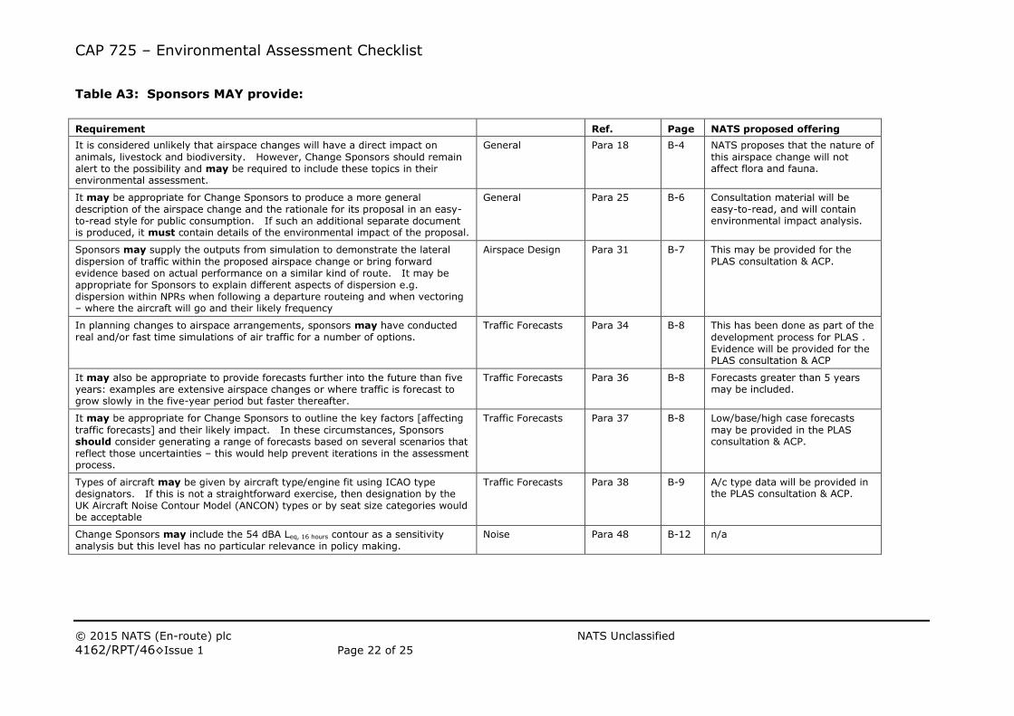
Table A3: Sponsors MAY provide:
Requirement Ref. Page NATS proposed offering
It is considered unlikely that airspace changes will have a direct impact on
animals, livestock and biodiversity. However, Change Sponsors should remain alert to the possibility and may be required to include these topics in their environmental assessment.
General Para 18 B-4 NATS proposes that the nature of
this airspace change will not affect flora and fauna.
It may be appropriate for Change Sponsors to produce a more general description of the airspace change and the rationale for its proposal in an easy-to-read style for public consumption. If such an additional separate document is produced, it must contain details of the environmental impact of the proposal.
General Para 25 B-6 Consultation material will be easy-to-read, and will contain environmental impact analysis.
Sponsors may supply the outputs from simulation to demonstrate the lateral
dispersion of traffic within the proposed airspace change or bring forward evidence based on actual performance on a similar kind of route. It may be appropriate for Sponsors to explain different aspects of dispersion e.g. dispersion within NPRs when following a departure routeing and when vectoring – where the aircraft will go and their likely frequency
Airspace Design Para 31 B-7 This may be provided for the PLAS consultation & ACP.
In planning changes to airspace arrangements, sponsors may have conducted real and/or fast time simulations of air traffic for a number of options.
Traffic Forecasts Para 34 B-8 This has been done as part of the
development process for PLAS . Evidence will be provided for the PLAS consultation & ACP
It may also be appropriate to provide forecasts further into the future than five years: examples are extensive airspace changes or where traffic is forecast to grow slowly in the five-year period but faster thereafter.
Traffic Forecasts Para 36 B-8 Forecasts greater than 5 years may be included.
It may be appropriate for Change Sponsors to outline the key factors [affecting
traffic forecasts] and their likely impact. In these circumstances, Sponsors should consider generating a range of forecasts based on several scenarios that reflect those uncertainties – this would help prevent iterations in the assessment process.
Traffic Forecasts Para 37 B-8 Low/base/high case forecasts
may be provided in the PLAS consultation & ACP.
Types of aircraft may be given by aircraft type/engine fit using ICAO type designators. If this is not a straightforward exercise, then designation by the UK Aircraft Noise Contour Model (ANCON) types or by seat size categories would be acceptable
Traffic Forecasts Para 38 B-9 A/c type data will be provided in the PLAS consultation & ACP.
Change Sponsors may include the 54 dBA Leq, 16 hours contour as a sensitivity analysis but this level has no particular relevance in policy making.
Noise Para 48 B-12 n/a
CAP 725 – Environmental Assessment Checklist
© 2015 NATS (En-route) plc NATS Unclassified
4162/RPT/46◊Issue 1 Page 23 of 25
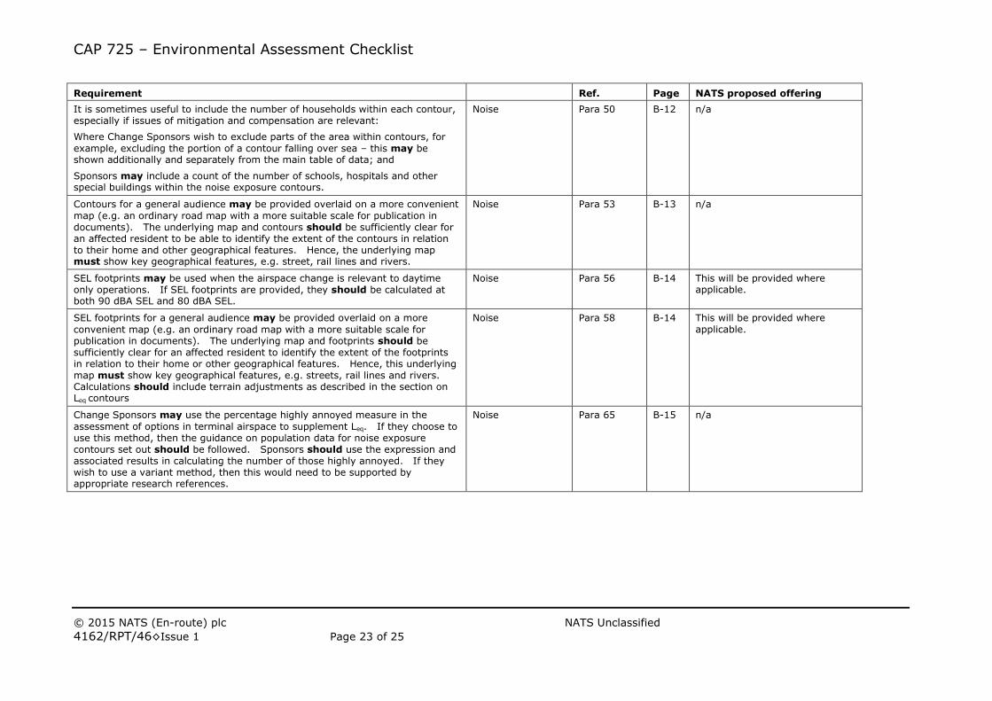
Requirement Ref. Page NATS proposed offering
It is sometimes useful to include the number of households within each contour, especially if issues of mitigation and compensation are relevant:
Where Change Sponsors wish to exclude parts of the area within contours, for
example, excluding the portion of a contour falling over sea – this may be shown additionally and separately from the main table of data; and
Sponsors may include a count of the number of schools, hospitals and other special buildings within the noise exposure contours.
Noise Para 50 B-12 n/a
Contours for a general audience may be provided overlaid on a more convenient
map (e.g. an ordinary road map with a more suitable scale for publication in documents). The underlying map and contours should be sufficiently clear for an affected resident to be able to identify the extent of the contours in relation to their home and other geographical features. Hence, the underlying map must show key geographical features, e.g. street, rail lines and rivers.
Noise Para 53 B-13 n/a
SEL footprints may be used when the airspace change is relevant to daytime only operations. If SEL footprints are provided, they should be calculated at both 90 dBA SEL and 80 dBA SEL.
Noise Para 56 B-14 This will be provided where applicable.
SEL footprints for a general audience may be provided overlaid on a more
convenient map (e.g. an ordinary road map with a more suitable scale for publication in documents). The underlying map and footprints should be sufficiently clear for an affected resident to identify the extent of the footprints in relation to their home or other geographical features. Hence, this underlying map must show key geographical features, e.g. streets, rail lines and rivers. Calculations should include terrain adjustments as described in the section on Leq contours
Noise Para 58 B-14 This will be provided where applicable.
Change Sponsors may use the percentage highly annoyed measure in the
assessment of options in terminal airspace to supplement Leq. If they choose to use this method, then the guidance on population data for noise exposure contours set out should be followed. Sponsors should use the expression and associated results in calculating the number of those highly annoyed. If they wish to use a variant method, then this would need to be supported by appropriate research references.
Noise Para 65 B-15 n/a
CAP 725 – Environmental Assessment Checklist
© 2015 NATS (En-route) plc NATS Unclassified
4162/RPT/46◊Issue 1 Page 24 of 25
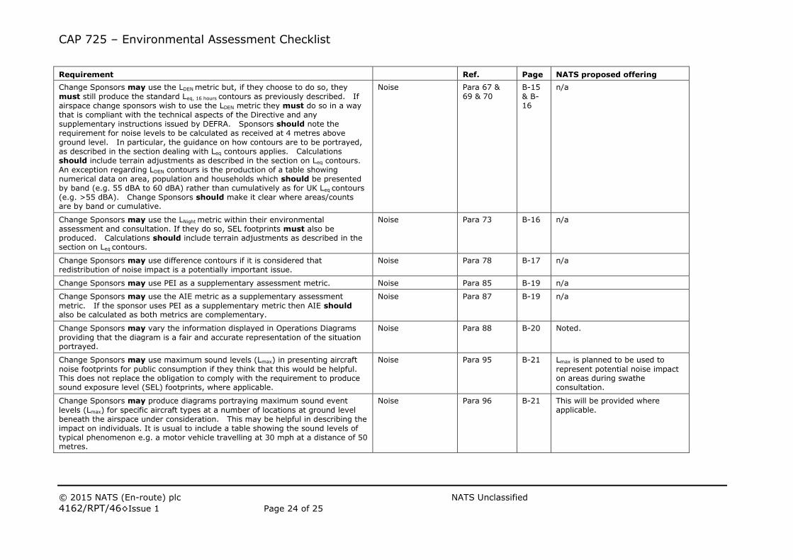
Requirement Ref. Page NATS proposed offering
Change Sponsors may use the LDEN metric but, if they choose to do so, they
must still produce the standard Leq, 16 hours contours as previously described. If airspace change sponsors wish to use the LDEN metric they must do so in a way that is compliant with the technical aspects of the Directive and any supplementary instructions issued by DEFRA. Sponsors should note the requirement for noise levels to be calculated as received at 4 metres above ground level. In particular, the guidance on how contours are to be portrayed, as described in the section dealing with Leq contours applies. Calculations should include terrain adjustments as described in the section on Leq contours. An exception regarding LDEN contours is the production of a table showing numerical data on area, population and households which should be presented by band (e.g. 55 dBA to 60 dBA) rather than cumulatively as for UK Leq contours (e.g. >55 dBA). Change Sponsors should make it clear where areas/counts are by band or cumulative.
Noise Para 67 & 69 & 70
B-15
& B-16
n/a
Change Sponsors may use the LNight metric within their environmental assessment and consultation. If they do so, SEL footprints must also be produced. Calculations should include terrain adjustments as described in the section on Leq contours.
Noise Para 73 B-16 n/a
Change Sponsors may use difference contours if it is considered that redistribution of noise impact is a potentially important issue.
Noise Para 78 B-17 n/a
Change Sponsors may use PEI as a supplementary assessment metric. Noise Para 85 B-19 n/a
Change Sponsors may use the AIE metric as a supplementary assessment
metric. If the sponsor uses PEI as a supplementary metric then AIE should also be calculated as both metrics are complementary.
Noise Para 87 B-19 n/a
Change Sponsors may vary the information displayed in Operations Diagrams
providing that the diagram is a fair and accurate representation of the situation portrayed.
Noise Para 88 B-20 Noted.
Change Sponsors may use maximum sound levels (Lmax) in presenting aircraft
noise footprints for public consumption if they think that this would be helpful. This does not replace the obligation to comply with the requirement to produce sound exposure level (SEL) footprints, where applicable.
Noise Para 95 B-21 Lmax is planned to be used to
represent potential noise impact on areas during swathe consultation.
Change Sponsors may produce diagrams portraying maximum sound event
levels (Lmax) for specific aircraft types at a number of locations at ground level beneath the airspace under consideration. This may be helpful in describing the impact on individuals. It is usual to include a table showing the sound levels of typical phenomenon e.g. a motor vehicle travelling at 30 mph at a distance of 50 metres.
Noise Para 96 B-21 This will be provided where applicable.
CAP 725 – Environmental Assessment Checklist
© 2015 NATS (En-route) plc NATS Unclassified
4162/RPT/46◊Issue 1 Page 25 of 25
Requirement Ref. Page NATS proposed offering
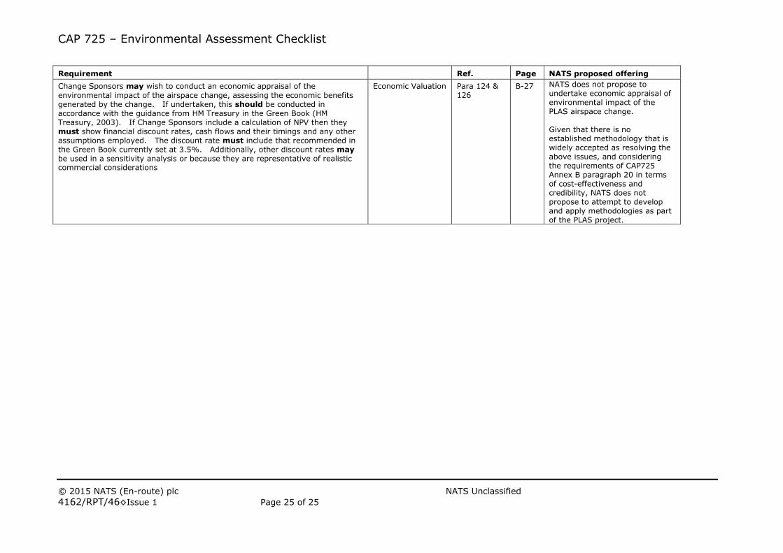
Change Sponsors may wish to conduct an economic appraisal of the
environmental impact of the airspace change, assessing the economic benefits generated by the change. If undertaken, this should be conducted in accordance with the guidance from HM Treasury in the Green Book (HM Treasury, 2003). If Change Sponsors include a calculation of NPV then they must show financial discount rates, cash flows and their timings and any other assumptions employed. The discount rate must include that recommended in the Green Book currently set at 3.5%. Additionally, other discount rates may be used in a sensitivity analysis or because they are representative of realistic commercial considerations
Economic Valuation Para 124 & 126
B-27 NATS does not propose to undertake economic appraisal of environmental impact of the PLAS airspace change. Given that there is no established methodology that is widely accepted as resolving the above issues, and considering the requirements of CAP725 Annex B paragraph 20 in terms of cost-effectiveness and credibility, NATS does not propose to attempt to develop and apply methodologies as part of the PLAS project.