presentation to association of british columbia land ...€¦ · topology 2. relative accuracy 3....
TRANSCRIPT
Base Mapping and Geomatic Services Slide 1ISO 9001:2000
INTEGRATED LAND MANAGEMENT BUREAUINTEGRATED LAND
MANAGEMENT BUREAU
Presentation to Association ofBritish Columbia Land Surveyors’ AGM
onBase Mapping in British Columbia
February 9, 2006Victoria
Amin Kassam, Director

Base Mapping and Geomatic Services Slide 2ISO 9001:2000
INTEGRATED LAND MANAGEMENT BUREAUINTEGRATED LAND
MANAGEMENT BUREAU

Base Mapping and Geomatic Services Slide 3ISO 9001:2000
INTEGRATED LAND MANAGEMENT BUREAUINTEGRATED LAND
MANAGEMENT BUREAU
BASE MAPPING & GEOMATIC SERVICES
Our MissionTo manage the Provincial Baseline Atlas as a corporate service for all government ministries, industry, business, academia and the public, in support of economic development and sustainability through better decisions.
► a 100+ years institution evolving from paper maps and gunther’s chain to digital data and satellites and from serving simple land settlement / management to very wide ranging, complex and inter-related activities / decisions on the land
Base Mapping and Geomatic Services Slide 4ISO 9001:2000
INTEGRATED LAND MANAGEMENT BUREAUINTEGRATED LAND
MANAGEMENT BUREAU
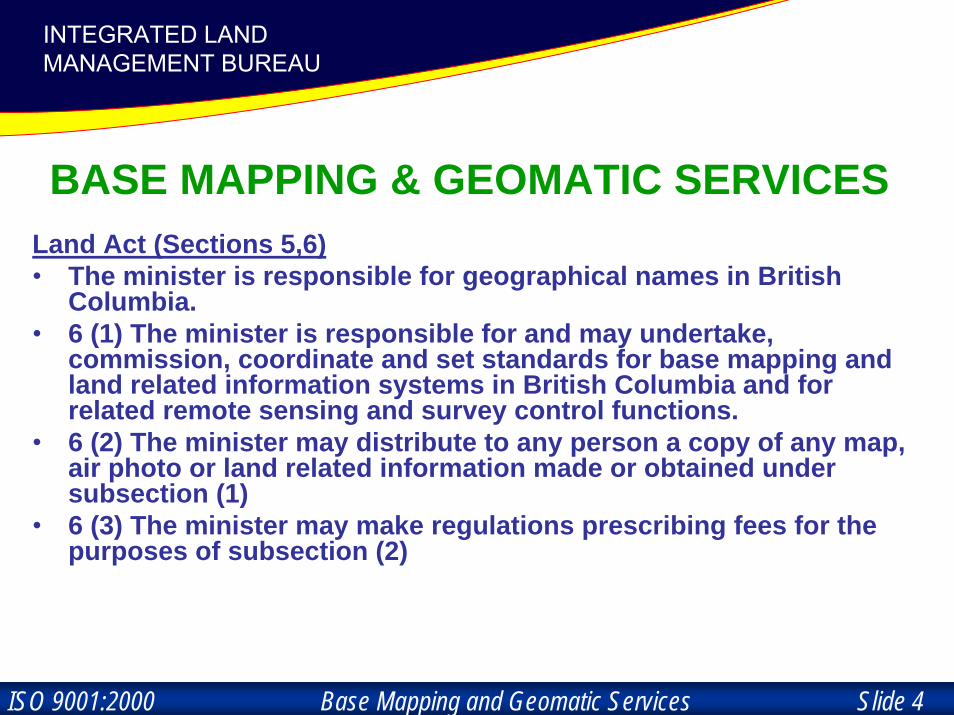
BASE MAPPING & GEOMATIC SERVICESLand Act (Sections 5,6)• The minister is responsible for geographical names in British
Columbia.• 6 (1) The minister is responsible for and may undertake,
commission, coordinate and set standards for base mapping and land related information systems in British Columbia and for related remote sensing and survey control functions.
• 6 (2) The minister may distribute to any person a copy of any map, air photo or land related information made or obtained under subsection (1)
• 6 (3) The minister may make regulations prescribing fees for thepurposes of subsection (2)
Base Mapping and Geomatic Services Slide 5ISO 9001:2000
INTEGRATED LAND MANAGEMENT BUREAUINTEGRATED LAND
MANAGEMENT BUREAU
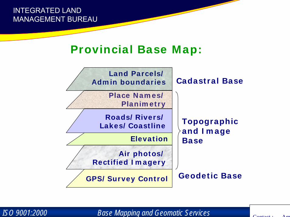
Provincial Base Map:
Land Parcels/Admin boundaries
Place Names/Planimetry
Geodetic Base
Roads/Rivers/Lakes/Coastline
Elevation
Air photos/Rectified Imagery
GPS/Survey Control
Cadastral Base
Topographicand Image Base
Contact : Ami
Base Mapping and Geomatic Services Slide 6ISO 9001:2000
INTEGRATED LAND MANAGEMENT BUREAUINTEGRATED LAND
MANAGEMENT BUREAU

Base Mapping and Geomatic Services Slide 7ISO 9001:2000
INTEGRATED LAND MANAGEMENT BUREAUINTEGRATED LAND
MANAGEMENT BUREAU
Geographical Names…a reflection of our natural and cultural heritage
Abandoned Locality: A previously populated locality with little or no current population.Airfield: A land aerodrome with limited services. Airport: Site intended for use by aircraft, including any necessary technical and commercial installations. Anchorage: An area of water in which vessels can anchor; usually sheltered water. Archipelago: Group or chain of islands…. …
Base Mapping and Geomatic Services Slide 8ISO 9001:2000
INTEGRATED LAND MANAGEMENT BUREAUINTEGRATED LAND
MANAGEMENT BUREAU
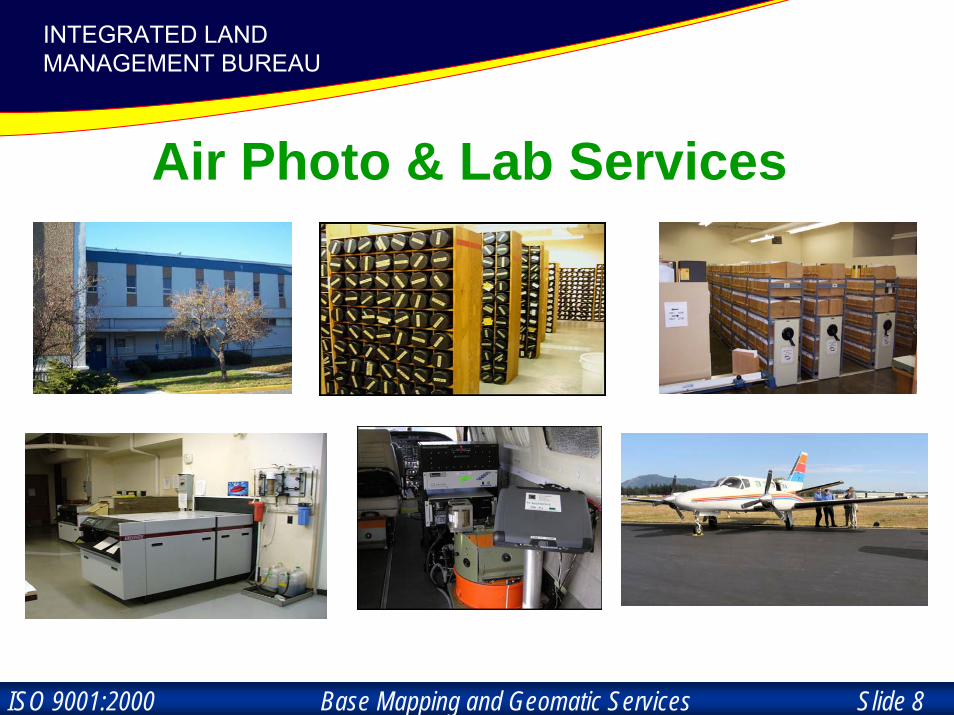
Air Photo & Lab Services

Base Mapping and Geomatic Services Slide 9ISO 9001:2000
INTEGRATED LAND MANAGEMENT BUREAUINTEGRATED LAND
MANAGEMENT BUREAU
Geo-Spatial Reference

Base Mapping and Geomatic Services Slide 10ISO 9001:2000
INTEGRATED LAND MANAGEMENT BUREAUINTEGRATED LAND
MANAGEMENT BUREAU
MASCOTdatabase
Base Mapping and Geomatic Services Slide 11ISO 9001:2000
INTEGRATED LAND MANAGEMENT BUREAUINTEGRATED LAND
MANAGEMENT BUREAU
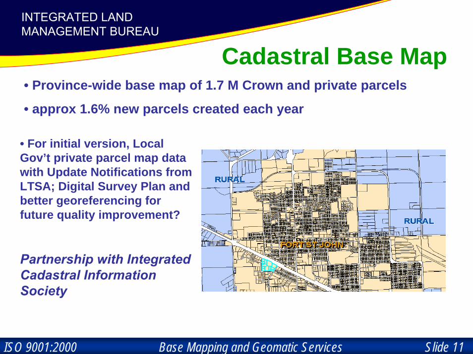
Cadastral Base Map• Province-wide base map of 1.7 M Crown and private parcels
• approx 1.6% new parcels created each year
• For initial version, Local Gov’t private parcel map data with Update Notifications from LTSA; Digital Survey Plan and better georeferencing for future quality improvement?
Partnership with Integrated Cadastral Information Society

Base Mapping and Geomatic Services Slide 12ISO 9001:2000
INTEGRATED LAND MANAGEMENT BUREAUINTEGRATED LAND
MANAGEMENT BUREAU
Seamless cadastral base map with attributes attached to each individual polygon
1. Topology2. Relative accuracy
3. Abs. accuracy
Base Mapping and Geomatic Services Slide 13ISO 9001:2000
INTEGRATED LAND MANAGEMENT BUREAUINTEGRATED LAND
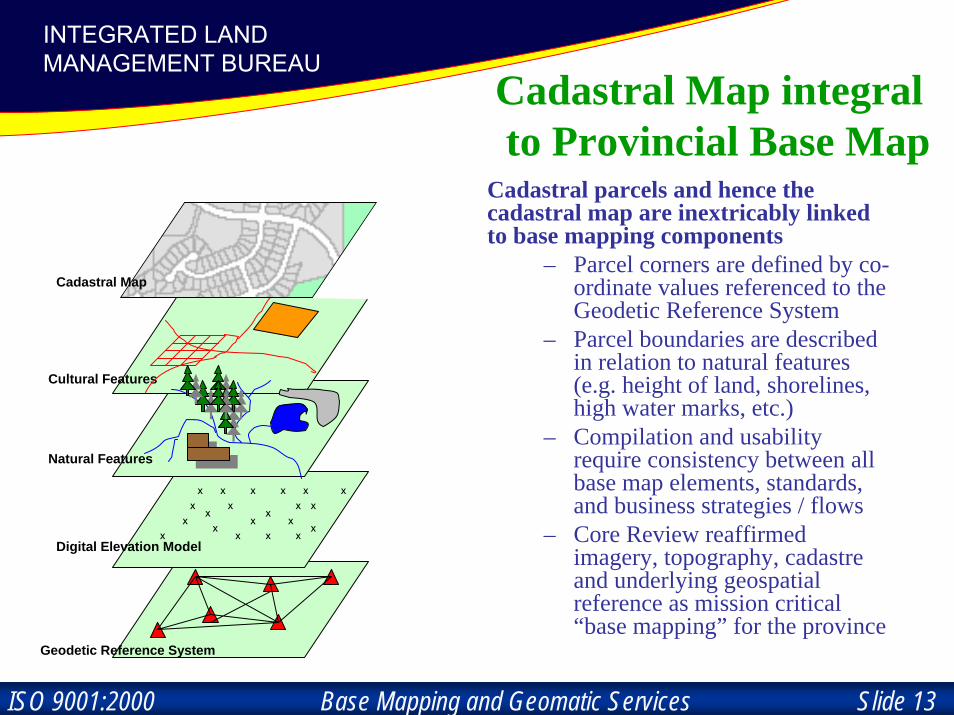
MANAGEMENT BUREAUCadastral Map integralto Provincial Base Map
Cadastral parcels and hence the cadastral map are inextricably linked to base mapping components
– Parcel corners are defined by co-ordinate values referenced to the Geodetic Reference System
– Parcel boundaries are described in relation to natural features (e.g. height of land, shorelines, high water marks, etc.)
– Compilation and usability require consistency between all base map elements, standards, and business strategies / flows
– Core Review reaffirmed imagery, topography, cadastre and underlying geospatial reference as mission critical “base mapping” for the province
Geodetic Reference System
Digital Elevation Modelx
x xx
x
x
x
xx
x x
x xx
xx
x
x
x x
x
Natural Features
Cultural Features
Cadastral MapCadastral Map
Base Mapping and Geomatic Services Slide 14ISO 9001:2000
INTEGRATED LAND MANAGEMENT BUREAUINTEGRATED LAND
MANAGEMENT BUREAU
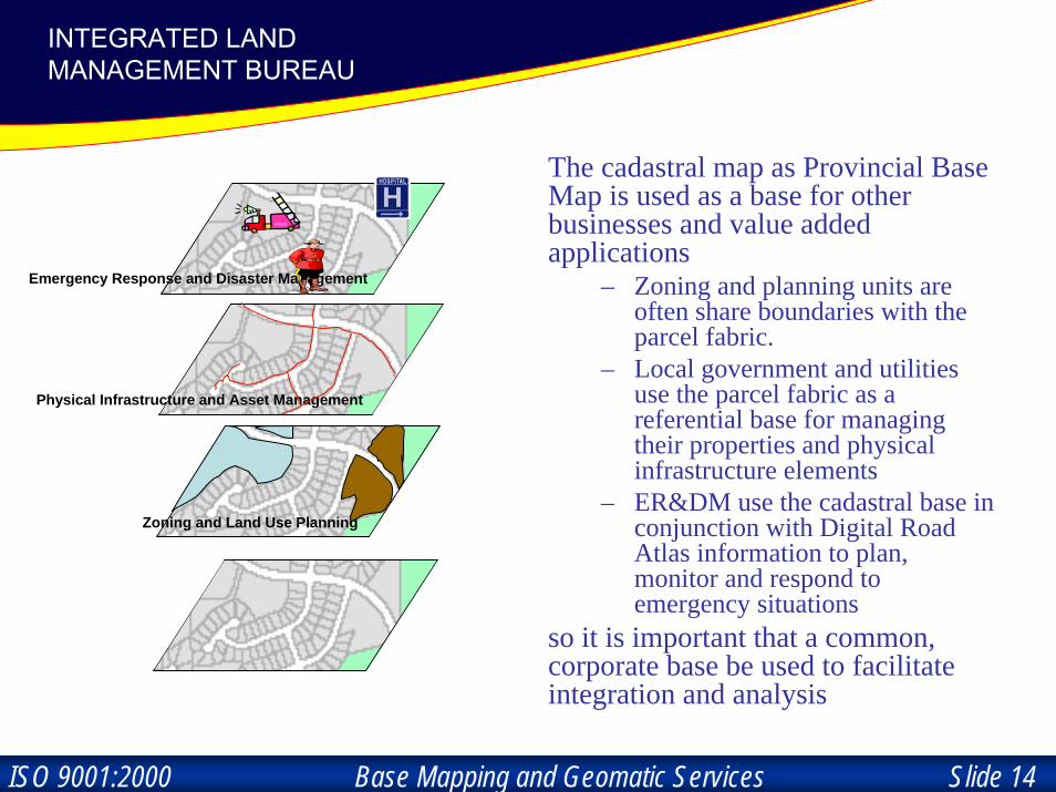
The cadastral map as Provincial Base Map is used as a base for other businesses and value added applications
– Zoning and planning units are often share boundaries with the parcel fabric.
– Local government and utilities use the parcel fabric as a referential base for managing their properties and physical infrastructure elements
– ER&DM use the cadastral base in conjunction with Digital Road Atlas information to plan, monitor and respond to emergency situations
so it is important that a common, corporate base be used to facilitate integration and analysis
Cadastral Map
Zoning and Land Use Planning
Physical Infrastructure and Asset Management
Emergency Response and Disaster Management
Zoning and Land Use Planning
Base Mapping and Geomatic Services Slide 15ISO 9001:2000
INTEGRATED LAND MANAGEMENT BUREAUINTEGRATED LAND
MANAGEMENT BUREAU
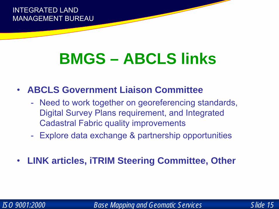
BMGS – ABCLS links
• ABCLS Government Liaison Committee- Need to work together on georeferencing standards,
Digital Survey Plans requirement, and Integrated Cadastral Fabric quality improvements
- Explore data exchange & partnership opportunities
• LINK articles, iTRIM Steering Committee, Other
Base Mapping and Geomatic Services Slide 16ISO 9001:2000
INTEGRATED LAND MANAGEMENT BUREAUINTEGRATED LAND
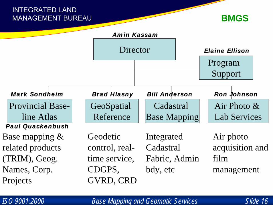
MANAGEMENT BUREAU BMGS
Director
Provincial Base-line Atlas
GeoSpatial Reference
Air Photo & Lab Services
Base mapping & related products (TRIM), Geog. Names, Corp. Projects
Geodetic control, real-time service, CDGPS, GVRD, CRD
Air photo acquisition and film management
Cadastral Base Mapping
Integrated Cadastral Fabric, Admin bdy, etc
Program Support
Mark SondheimMark Sondheim Brad Brad HlasnyHlasny Bill AndersonBill Anderson Ron JohnsonRon Johnson
Elaine EllisonElaine Ellison
Amin Amin KassamKassam
Paul Paul QuackenbushQuackenbush

Base Mapping and Geomatic Services Slide 17ISO 9001:2000
INTEGRATED LAND MANAGEMENT BUREAUINTEGRATED LAND
MANAGEMENT BUREAU
CadastralCadastralBaseBase
TopographicTopographicBaseBase
Image BaseImage Base
GeodeticGeodeticBaseBase
DataAnd
Services
DataDataAnd And
ServicesServices
CCLLIIEENNTTSS
Base Mapping and Geomatic Services Slide 18ISO 9001:2000
INTEGRATED LAND MANAGEMENT BUREAUINTEGRATED LAND
MANAGEMENT BUREAU
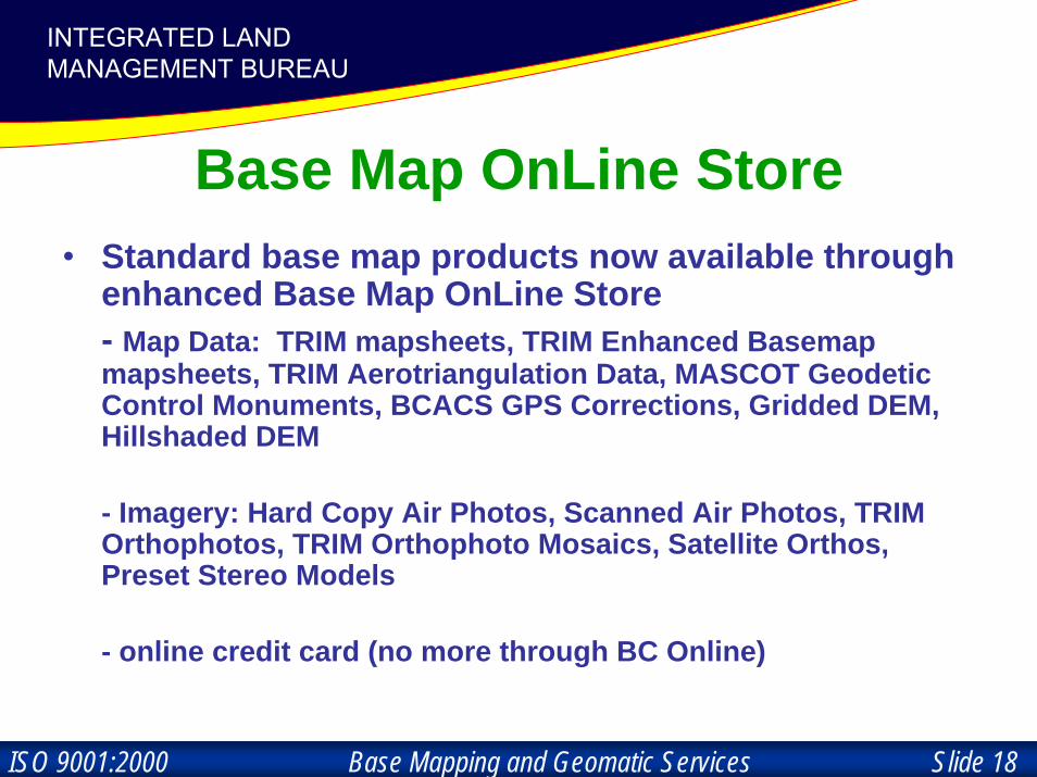
Base Map OnLine Store• Standard base map products now available through
enhanced Base Map OnLine Store- Map Data: TRIM mapsheets, TRIM Enhanced Basemapmapsheets, TRIM Aerotriangulation Data, MASCOT Geodetic Control Monuments, BCACS GPS Corrections, Gridded DEM, Hillshaded DEM
- Imagery: Hard Copy Air Photos, Scanned Air Photos, TRIM Orthophotos, TRIM Orthophoto Mosaics, Satellite Orthos, Preset Stereo Models
- online credit card (no more through BC Online)
Base Mapping and Geomatic Services Slide 19ISO 9001:2000
INTEGRATED LAND MANAGEMENT BUREAUINTEGRATED LAND
MANAGEMENT BUREAU
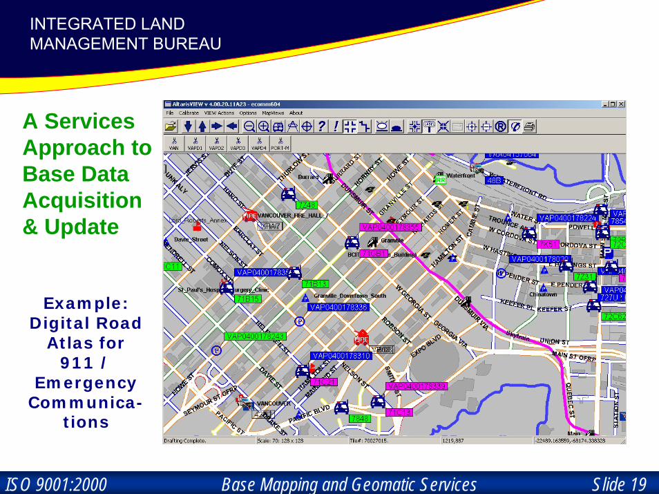
Example: Digital Road
Atlas for 911 /
Emergency Communica-
tions
A Services Approach to Base Data Acquisition & Update

Base Mapping and Geomatic Services Slide 20ISO 9001:2000
INTEGRATED LAND MANAGEMENT BUREAUINTEGRATED LAND
MANAGEMENT BUREAU
Base Data Services: Roads,
Elevation & Imagery for
Evacuation and Assessment
during Forest Fires

Base Mapping and Geomatic Services Slide 21ISO 9001:2000
INTEGRATED LAND MANAGEMENT BUREAUINTEGRATED LAND
MANAGEMENT BUREAU
Base Mapping Challenge:
• provide and infuse standardized, up-to-date basemapping into all land, resource, social and economicspheres
• provide effective services and tools
• collaboration, partnership, and client focus

Base Mapping and Geomatic Services Slide 22ISO 9001:2000
INTEGRATED LAND MANAGEMENT BUREAUINTEGRATED LAND
MANAGEMENT BUREAU

Base Mapping and Geomatic Services Slide 23ISO 9001:2000
INTEGRATED LAND MANAGEMENT BUREAUINTEGRATED LAND
MANAGEMENT BUREAU

Base Mapping and Geomatic Services Slide 24ISO 9001:2000
INTEGRATED LAND MANAGEMENT BUREAUINTEGRATED LAND
MANAGEMENT BUREAU
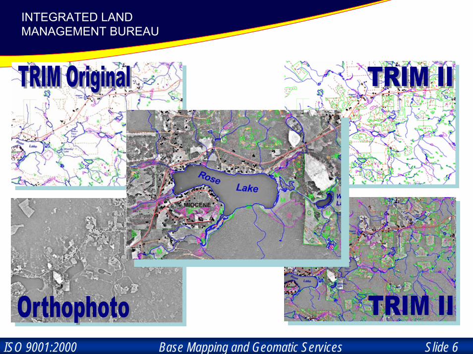
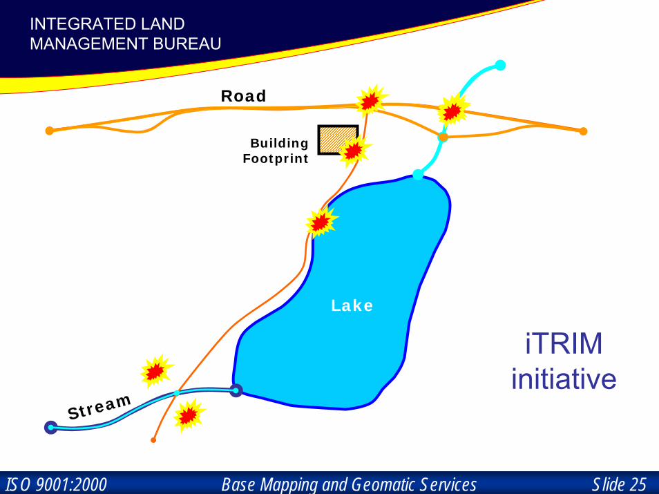
TRIMData
Exchange
Base Mapping and Geomatic Services Slide 25ISO 9001:2000
INTEGRATED LAND MANAGEMENT BUREAUINTEGRATED LAND
MANAGEMENT BUREAU
Lake
Stream
Road
BuildingFootprint
iTRIM initiative

Base Mapping and Geomatic Services Slide 26ISO 9001:2000
INTEGRATED LAND MANAGEMENT BUREAUINTEGRATED LAND
MANAGEMENT BUREAU
Imagery
Note: DRA, CWB, TRIM, CBM all require an image environment to ensure quality

Base Mapping and Geomatic Services Slide 27ISO 9001:2000
INTEGRATED LAND MANAGEMENT BUREAUINTEGRATED LAND
MANAGEMENT BUREAU
TRIM –CHS
Coastal

Base Mapping and Geomatic Services Slide 28ISO 9001:2000
INTEGRATED LAND MANAGEMENT BUREAUINTEGRATED LAND
MANAGEMENT BUREAU
Geo-Spatial Reference: NAD83 (CSRS)

Base Mapping and Geomatic Services Slide 29ISO 9001:2000
INTEGRATED LAND MANAGEMENT BUREAUINTEGRATED LAND
MANAGEMENT BUREAU
0%0%0%0%0%0%0%0%0%0%0%0%0%0%0%0%0%0%0%0%0%0%0%0%0%0%0%0%0%0%0%0%0%0%0%0%0%0%0%0%0%0%0%0%0%0%0%0%0%0%0%0%0%0%0%0%0%0%0%0%0%0%0%0%0%0%0%0%0%0%0%0%0%0%0%0%0%0%0%0%0%0%0%0%0%0%0%0%0%0%0%0%0%0%0%0%0%0%0%0%0%0%0%0%0%0%0%0%0%0%0%0%0%0%0%0%0%0%0%0%0%0%0%0%0%0%0%0%0%0%0%0%0%0%0%0%0%0%0%0%0%0%0%0%0%0%0%0%0%0%0%0%0%0%0%0%0%0%0%0%0%0%0%0%0%0%0%0%0%0%0%0%0%0%0%0%0%0%0%0%0%0%0%0%0%0%0%0%0%0%0%0%0%0%0%0%0%0%0%0%0%0%0%0%0%0%0%0%0%0%0%0%0%0%0%0%0%0%0%0%0%0%0%0%0%0%0%0%0%
Education; Equipment,
ales & testing2%
Transportation & Utilities
3%Oil & Gas, Geotech, Mineral
Exploration7%
Aerial Mapping,
Photogrammetry
3%
Environment, Water
2%
Engineering, Surveying,
Mapping, GIS31%
Cadastral ties and
mapping24%
Engineering24%
Forestry4%
Note: Users also access GSR through BC ACS and indirectly through base-mapping / other mapping
GSR Users

Base Mapping and Geomatic Services Slide 30ISO 9001:2000
INTEGRATED LAND MANAGEMENT BUREAUINTEGRATED LAND
MANAGEMENT BUREAU
Blind GPS / DGPS Blind GPS / DGPS Data integrationData integration
TRIM
Road
TRIM
Road
TRIM StreamTRIM Stream
TRIM IITRIM IIOrthophotoOrthophoto
GPSGPSStreamStream
30 m30 m

Base Mapping and Geomatic Services Slide 31ISO 9001:2000
INTEGRATED LAND MANAGEMENT BUREAUINTEGRATED LAND
MANAGEMENT BUREAU
GPS ConstellationGPS Constellation
MSATMSAT--11CommunicationsCommunications
SatelliteSatellite
UserUserGPSGPS
Mobile GISMobile GISApplicationsApplications
CDGPS End User Interface
CDGPS CDGPS ReceiverReceiver

Base Mapping and Geomatic Services Slide 32ISO 9001:2000
INTEGRATED LAND MANAGEMENT BUREAUINTEGRATED LAND
MANAGEMENT BUREAU
Canada-wide Differential GPS Service (CDGPS)
A Canadian Federal/Provincial/Territorial collaborative program led by BMGS to provide;
• public infrastructure of real-time GPS Corrections (“GPS••C”) via MSAT
• develop an initial user radio/receiver.• create enabling environment forprivate sector adoption of the infrastructure
GPSCDGPS
Coast
Guard
U.S. WAAS

Base Mapping and Geomatic Services Slide 33ISO 9001:2000
INTEGRATED LAND MANAGEMENT BUREAUINTEGRATED LAND
MANAGEMENT BUREAU
VERTICAL DATUM MODERNIZATION
• Long overdue – need to harmonize with global 3-D datum
• Federal-Provincial-Territorial study on national requirements underway through Canadaian Council on Geomatics
• BMGS will draw provincial strategy• Feedback to BMGS welcome• Adoption over decade or more?

Base Mapping and Geomatic Services Slide 34ISO 9001:2000
INTEGRATED LAND MANAGEMENT BUREAUINTEGRATED LAND
MANAGEMENT BUREAU
Base Mapping Governance• Corporate Base Mapping Advisory Committee
► Standard Operating Procedures
• Project steering committees / working groups► Stakeholder / client participation
• ISO Certification – Quality Management System

Base Mapping and Geomatic Services Slide 35ISO 9001:2000
INTEGRATED LAND MANAGEMENT BUREAUINTEGRATED LAND
MANAGEMENT BUREAU
Canada-wideDGPS Service
NationalRoad
Network
NationalHydrographic
Network…
National Standards / Easy Access
Standards & ToolsISO 9001:2000 Certification
Base Mapping and Geomatic Services Slide 36ISO 9001:2000
INTEGRATED LAND MANAGEMENT BUREAUINTEGRATED LAND
MANAGEMENT BUREAU
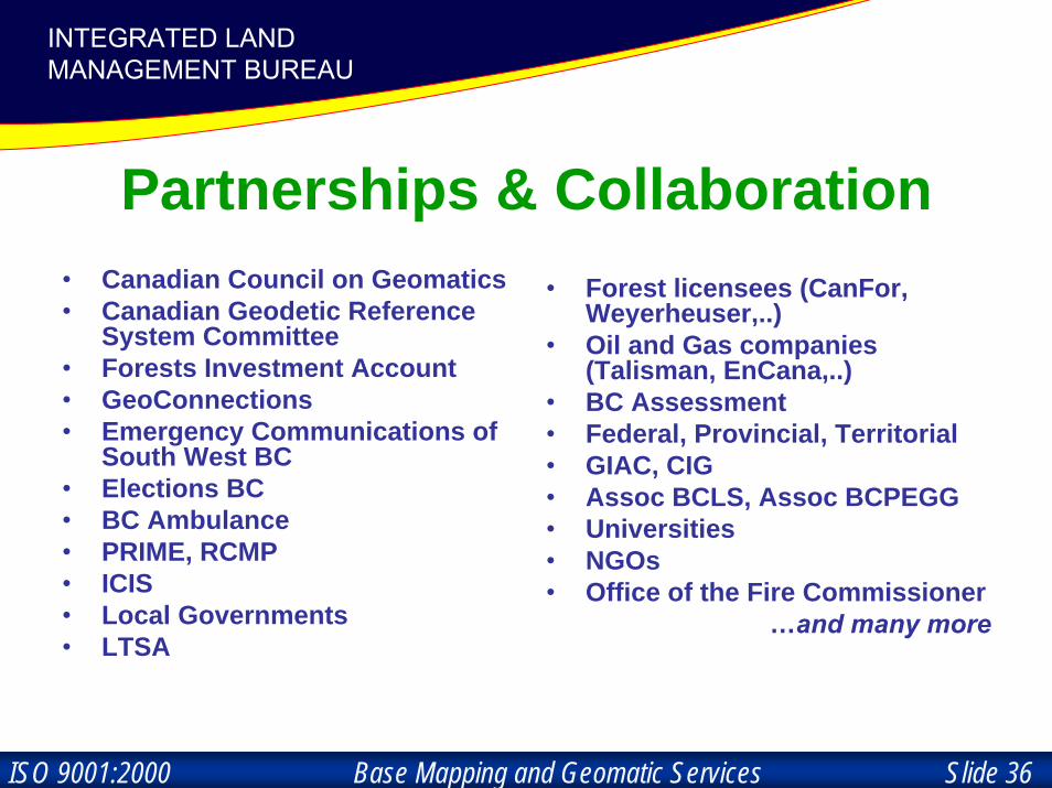
Partnerships & Collaboration• Canadian Council on Geomatics• Canadian Geodetic Reference
System Committee• Forests Investment Account• GeoConnections• Emergency Communications of
South West BC• Elections BC• BC Ambulance• PRIME, RCMP• ICIS• Local Governments• LTSA
• Forest licensees (CanFor, Weyerheuser,..)
• Oil and Gas companies (Talisman, EnCana,..)
• BC Assessment• Federal, Provincial, Territorial• GIAC, CIG• Assoc BCLS, Assoc BCPEGG• Universities• NGOs• Office of the Fire Commissioner
…and many more

Base Mapping and Geomatic Services Slide 37ISO 9001:2000
INTEGRATED LAND MANAGEMENT BUREAUINTEGRATED LAND
MANAGEMENT BUREAU
5 ACP Site Locations
Greater Vancouver Regional Districtgeo-spatial reference project

Base Mapping and Geomatic Services Slide 38ISO 9001:2000
INTEGRATED LAND MANAGEMENT BUREAUINTEGRATED LAND
MANAGEMENT BUREAU GVRD ServiceThe establishment of a high accuracy and consistent real-time GPS based
geo-spatial reference system in the Greater Vancouver Regional District…
• Passive (or physical) monumented system– Upgrade & extension of the passive (physical) monumented system
to support real-time service and eliminate (minimize) maintenance.• Active (or satellite-based) monumented system
– Post-Mission Service– Real-Time Service: Horizontal 4cm @95% at 20km separation from ACP
Vertical: 6cm @95% at 20km separation from ACP– DGPS: metre-level anywhere in Bell coverage– Availability: Unlimited, 24x7 real-time access to service.– Open standards
• Supporting Geodetic Tools– Geoid, Transformation grid files, FAQs, etc.
• Specifications– compatibility with ISA regulations
• Education• Governance / Roles & Responsibilities

Base Mapping and Geomatic Services Slide 39ISO 9001:2000
INTEGRATED LAND MANAGEMENT BUREAUINTEGRATED LAND
MANAGEMENT BUREAU Passive HPN

Base Mapping and Geomatic Services Slide 40ISO 9001:2000
INTEGRATED LAND MANAGEMENT BUREAUINTEGRATED LAND
MANAGEMENT BUREAUGVRD Vertical Datum Refresh Adjustment

Base Mapping and Geomatic Services Slide 41ISO 9001:2000
INTEGRATED LAND MANAGEMENT BUREAUINTEGRATED LAND
MANAGEMENT BUREAUGVRD Horizontal Coordinates Refresh Adjustment

Base Mapping and Geomatic Services Slide 42ISO 9001:2000
INTEGRATED LAND MANAGEMENT BUREAUINTEGRATED LAND
MANAGEMENT BUREAU Active System
Maple Ridge
Langley City
Vancouver
Delta
Surrey
0 5
Kilometers
10
BCACSm-GVRD Active Control Point LayoutRTK Baseline Solution Option
20km
Base Mapping and Geomatic Services Slide 43ISO 9001:2000
INTEGRATED LAND MANAGEMENT BUREAUINTEGRATED LAND
MANAGEMENT BUREAU
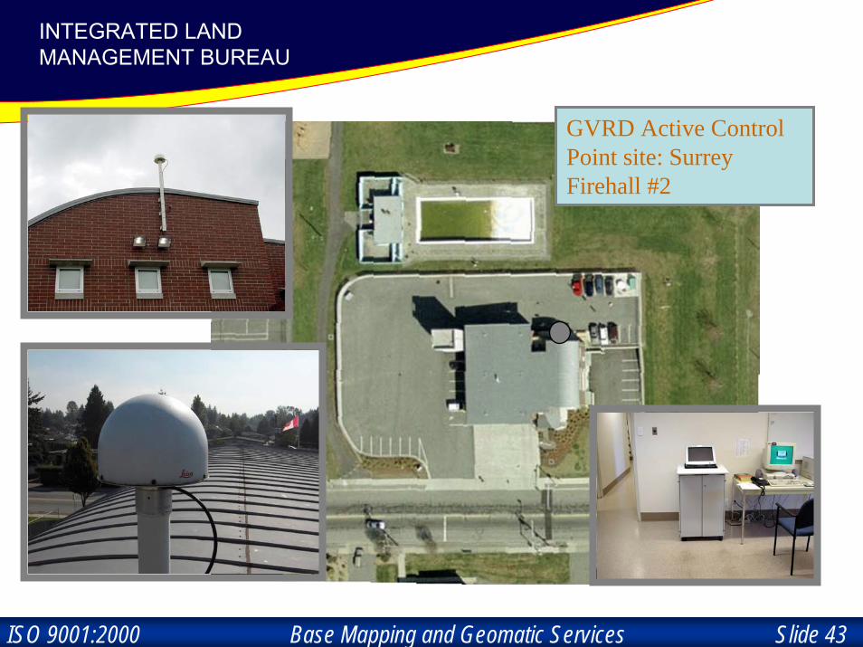
GVRD Active Control Point site: Surrey Firehall #2

Base Mapping and Geomatic Services Slide 44ISO 9001:2000
INTEGRATED LAND MANAGEMENT BUREAUINTEGRATED LAND
MANAGEMENT BUREAU User RTK
Base Mapping and Geomatic Services Slide 45ISO 9001:2000
INTEGRATED LAND MANAGEMENT BUREAUINTEGRATED LAND
MANAGEMENT BUREAU
GVRD Service Benefits• Supports real-time 3D positioning with two proven technologies,
the centimetres-level RTK or the metre-level DGPS operations;• Offers 24/7 managed data service and help desk support;• Reduces costs by eliminating government-regulated radio licences
and also eliminates the need to establish and secure expensive user-owned reference systems;
• Increases productivity with highly portable GPS systems• Provides access to the most modern region of provincial geospatial
reference system, which is endorsed by the GVRD member municipalities; and
• Reduces physical infrastructure costs for the installation, survey, maintenance and replacement of many densely located survey control monuments.
• Potential applications include cadastral surveys, engineering layouts, topographic surveys, GIS mapping, hydrographic surveys, fleet management and similar activities.
Base Mapping and Geomatic Services Slide 46ISO 9001:2000
INTEGRATED LAND MANAGEMENT BUREAUINTEGRATED LAND
MANAGEMENT BUREAU
Testimonials• “Using RTK will enable Coquitlam to derive significant
savings when establishing a baseline control network for subsequent local surveys – in particular, the new real-time GPS will be useful for topographic surveys, photo control for mapping projects, and for surveying remote areas of Coquitlam”Henry Wong, City of Coquitlam
• “The new service is great! Corrections are available on the fly, and coverage is extensive. Most importantly, there is no base station to set up”

Base Mapping and Geomatic Services Slide 47ISO 9001:2000
INTEGRATED LAND MANAGEMENT BUREAUINTEGRATED LAND
MANAGEMENT BUREAU
Testimonials
• “Overall, we have seen significant time and cost savings using the GVRD GPS real-time service and would highly recommend the system to any company who undertakes these types of projects.”Dennis Stock, Engineering Design & Construction, City of Richmond
• “The GVRD Service provides us benefits of reducing our expenditures on survey control by more than all expenditures for the Service, and of extending hydrographic surveys into areas where survey control was previously hard to establish.” Gouin Barford, Discipline Head, Civil Marine Engineering, Public Works and Government Service of Canada

Base Mapping and Geomatic Services Slide 48ISO 9001:2000
INTEGRATED LAND MANAGEMENT BUREAUINTEGRATED LAND
MANAGEMENT BUREAUSubscription Plan
2006 Subscription Fee• The public can have unlimited data access to the GPS real-time
service by subscribing to the following available rate plans:– Annual Rate - $2,400, or– Monthly Rate - $250– Rate plans for the 2007 calendar year will be announced in the
fall. Note: calendar-year plans that continue into 2006 will be honoured at the 2006 rate.
Special Offer for BCLS• Three Month Free-Trial Subscriptions are available to a limited
number of eligible companies operating in the Lower Mainland. • Participants agree to be interviewed after the free-trial period,
and will complete a questionnaire.• For more information …
– Please contact George Liu of the GVRD– Brad Hlasny at the Ministry Booth in the Exhibit hall, or – http://srmwww.gov.bc.ca/bmgs/bcacs/bcacsm/bcacsmhome.htm/

Base Mapping and Geomatic Services Slide 49ISO 9001:2000
INTEGRATED LAND MANAGEMENT BUREAUINTEGRATED LAND
MANAGEMENT BUREAU
Thank you !
Amin Kassam250-387-9321