preliminary seismic hazard assessments for the area of ... · preliminary seismic hazard...
TRANSCRIPT
163
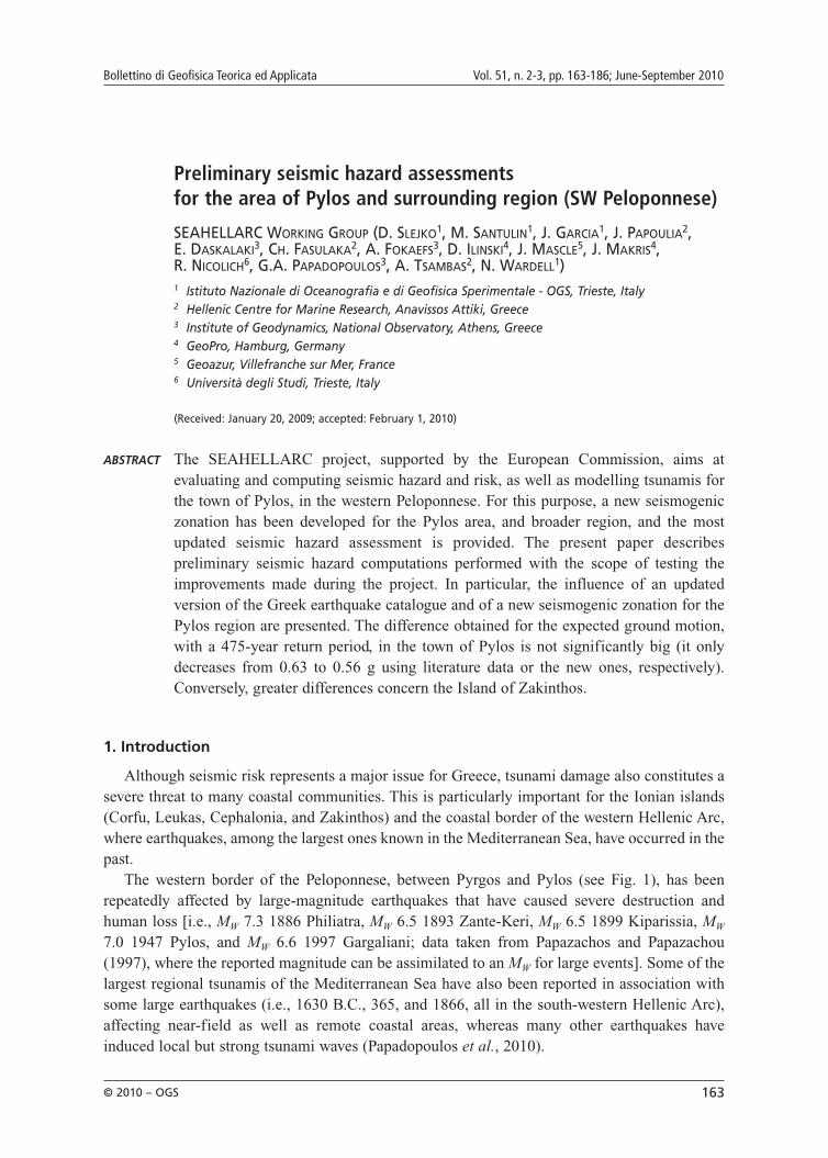
Preliminary seismic hazard assessments for the area of Pylos and surrounding region (SW Peloponnese)
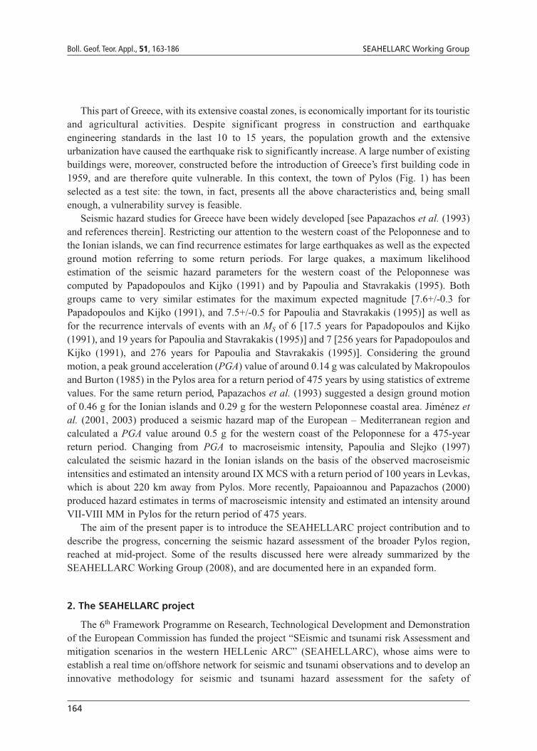
SEAHELLARC WORKING GROUP (D. SLEJKO1, M. SANTULIN1, J. GARCIA1, J. PAPOULIA2, E. DASKALAKI3, CH. FASULAKA2, A. FOKAEFS3, D. ILINSKI4, J. MASCLE5, J. MAKRIS4, R. NICOLICH6, G.A. PAPADOPOULOS3, A. TSAMBAS2, N. WARDELL1)1 Istituto Nazionale di Oceanografia e di Geofisica Sperimentale - OGS, Trieste, Italy2 Hellenic Centre for Marine Research, Anavissos Attiki, Greece3 Institute of Geodynamics, National Observatory, Athens, Greece4 GeoPro, Hamburg, Germany5 Geoazur, Villefranche sur Mer, France6 Università degli Studi, Trieste, Italy
(Received: January 20, 2009; accepted: February 1, 2010)
ABSTRACT The SEAHELLARC project, supported by the European Commission, aims atevaluating and computing seismic hazard and risk, as well as modelling tsunamis forthe town of Pylos, in the western Peloponnese. For this purpose, a new seismogeniczonation has been developed for the Pylos area, and broader region, and the mostupdated seismic hazard assessment is provided. The present paper describespreliminary seismic hazard computations performed with the scope of testing theimprovements made during the project. In particular, the influence of an updatedversion of the Greek earthquake catalogue and of a new seismogenic zonation for thePylos region are presented. The difference obtained for the expected ground motion,with a 475-year return period, in the town of Pylos is not significantly big (it onlydecreases from 0.63 to 0.56 g using literature data or the new ones, respectively).Conversely, greater differences concern the Island of Zakinthos.
1. Introduction
Although seismic risk represents a major issue for Greece, tsunami damage also constitutes asevere threat to many coastal communities. This is particularly important for the Ionian islands(Corfu, Leukas, Cephalonia, and Zakinthos) and the coastal border of the western Hellenic Arc,where earthquakes, among the largest ones known in the Mediterranean Sea, have occurred in thepast.
The western border of the Peloponnese, between Pyrgos and Pylos (see Fig. 1), has beenrepeatedly affected by large-magnitude earthquakes that have caused severe destruction andhuman loss [i.e., MW 7.3 1886 Philiatra, MW 6.5 1893 Zante-Keri, MW 6.5 1899 Kiparissia, MW
7.0 1947 Pylos, and MW 6.6 1997 Gargaliani; data taken from Papazachos and Papazachou(1997), where the reported magnitude can be assimilated to an MW for large events]. Some of thelargest regional tsunamis of the Mediterranean Sea have also been reported in association withsome large earthquakes (i.e., 1630 B.C., 365, and 1866, all in the south-western Hellenic Arc),affecting near-field as well as remote coastal areas, whereas many other earthquakes haveinduced local but strong tsunami waves (Papadopoulos et al., 2010).
Bollettino di Geofisica Teorica ed Applicata Vol. 51, n. 2-3, pp. 163-186; June-September 2010
© 2010 – OGS
164
Boll. Geof. Teor. Appl., 51, 163-186 SEAHELLARC Working Group
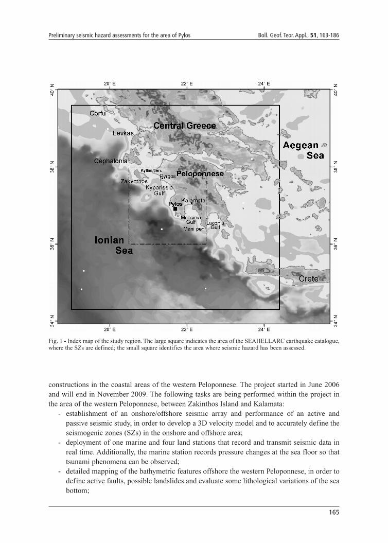
This part of Greece, with its extensive coastal zones, is economically important for its touristicand agricultural activities. Despite significant progress in construction and earthquakeengineering standards in the last 10 to 15 years, the population growth and the extensiveurbanization have caused the earthquake risk to significantly increase. A large number of existingbuildings were, moreover, constructed before the introduction of Greece’s first building code in1959, and are therefore quite vulnerable. In this context, the town of Pylos (Fig. 1) has beenselected as a test site: the town, in fact, presents all the above characteristics and, being smallenough, a vulnerability survey is feasible.
Seismic hazard studies for Greece have been widely developed [see Papazachos et al. (1993)and references therein]. Restricting our attention to the western coast of the Peloponnese and tothe Ionian islands, we can find recurrence estimates for large earthquakes as well as the expectedground motion referring to some return periods. For large quakes, a maximum likelihoodestimation of the seismic hazard parameters for the western coast of the Peloponnese wascomputed by Papadopoulos and Kijko (1991) and by Papoulia and Stavrakakis (1995). Bothgroups came to very similar estimates for the maximum expected magnitude [7.6+/-0.3 forPapadopoulos and Kijko (1991), and 7.5+/-0.5 for Papoulia and Stavrakakis (1995)] as well asfor the recurrence intervals of events with an MS of 6 [17.5 years for Papadopoulos and Kijko(1991), and 19 years for Papoulia and Stavrakakis (1995)] and 7 [256 years for Papadopoulos andKijko (1991), and 276 years for Papoulia and Stavrakakis (1995)]. Considering the groundmotion, a peak ground acceleration (PGA) value of around 0.14 g was calculated by Makropoulosand Burton (1985) in the Pylos area for a return period of 475 years by using statistics of extremevalues. For the same return period, Papazachos et al. (1993) suggested a design ground motionof 0.46 g for the Ionian islands and 0.29 g for the western Peloponnese coastal area. Jiménez etal. (2001, 2003) produced a seismic hazard map of the European – Mediterranean region andcalculated a PGA value around 0.5 g for the western coast of the Peloponnese for a 475-yearreturn period. Changing from PGA to macroseismic intensity, Papoulia and Slejko (1997)calculated the seismic hazard in the Ionian islands on the basis of the observed macroseismicintensities and estimated an intensity around IX MCS with a return period of 100 years in Levkas,which is about 220 km away from Pylos. More recently, Papaioannou and Papazachos (2000)produced hazard estimates in terms of macroseismic intensity and estimated an intensity aroundVII-VIII MM in Pylos for the return period of 475 years.
The aim of the present paper is to introduce the SEAHELLARC project contribution and todescribe the progress, concerning the seismic hazard assessment of the broader Pylos region,reached at mid-project. Some of the results discussed here were already summarized by theSEAHELLARC Working Group (2008), and are documented here in an expanded form.
2. The SEAHELLARC project
The 6th Framework Programme on Research, Technological Development and Demonstrationof the European Commission has funded the project “SEismic and tsunami risk Assessment andmitigation scenarios in the western HELLenic ARC” (SEAHELLARC), whose aims were toestablish a real time on/offshore network for seismic and tsunami observations and to develop aninnovative methodology for seismic and tsunami hazard assessment for the safety of
165
Preliminary seismic hazard assessments for the area of Pylos Boll. Geof. Teor. Appl., 51, 163-186
constructions in the coastal areas of the western Peloponnese. The project started in June 2006and will end in November 2009. The following tasks are being performed within the project inthe area of the western Peloponnese, between Zakinthos Island and Kalamata:
- establishment of an onshore/offshore seismic array and performance of an active andpassive seismic study, in order to develop a 3D velocity model and to accurately define theseismogenic zones (SZs) in the onshore and offshore area;
- deployment of one marine and four land stations that record and transmit seismic data inreal time. Additionally, the marine station records pressure changes at the sea floor so thattsunami phenomena can be observed;
- detailed mapping of the bathymetric features offshore the western Peloponnese, in order todefine active faults, possible landslides and evaluate some lithological variations of the seabottom;
Fig. 1 - Index map of the study region. The large square indicates the area of the SEAHELLARC earthquake catalogue,where the SZs are defined; the small square identifies the area where seismic hazard has been assessed.
166
Boll. Geof. Teor. Appl., 51, 163-186 SEAHELLARC Working Group
- reprocessing and re-evaluation of former multichannel seismic reflection (MSR) data inorder to refine our understanding of the overall geological structural framework of theoffshore domain;
- seismic hazard assessment, considering simultaneously on/ and offshore data;- identification of potential seismic and non-seismic tsunamigenic sources and estimation of
their geometry and dimensions;- pilot study for the area of Pylos for seismic and tsunami risk and mitigation scenarios;- establishment of a permanent marine broadband seismic station, for integration in the
permanent national seismological network of Greece.
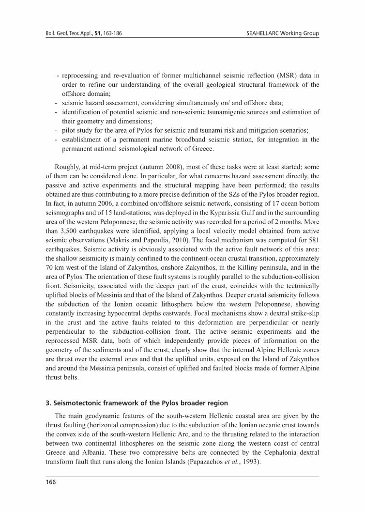
Roughly, at mid-term project (autumn 2008), most of these tasks were at least started; someof them can be considered done. In particular, for what concerns hazard assessment directly, thepassive and active experiments and the structural mapping have been performed; the resultsobtained are thus contributing to a more precise definition of the SZs of the Pylos broader region.In fact, in autumn 2006, a combined on/offshore seismic network, consisting of 17 ocean bottomseismographs and of 15 land-stations, was deployed in the Kyparissia Gulf and in the surroundingarea of the western Peloponnese; the seismic activity was recorded for a period of 2 months. Morethan 3,500 earthquakes were identified, applying a local velocity model obtained from activeseismic observations (Makris and Papoulia, 2010). The focal mechanism was computed for 581earthquakes. Seismic activity is obviously associated with the active fault network of this area:the shallow seismicity is mainly confined to the continent-ocean crustal transition, approximately70 km west of the Island of Zakynthos, onshore Zakynthos, in the Killiny peninsula, and in thearea of Pylos. The orientation of these fault systems is roughly parallel to the subduction-collisionfront. Seismicity, associated with the deeper part of the crust, coincides with the tectonicallyuplifted blocks of Messinia and that of the Island of Zakynthos. Deeper crustal seismicity followsthe subduction of the Ionian oceanic lithosphere below the western Peloponnese, showingconstantly increasing hypocentral depths eastwards. Focal mechanisms show a dextral strike-slipin the crust and the active faults related to this deformation are perpendicular or nearlyperpendicular to the subduction-collision front. The active seismic experiments and thereprocessed MSR data, both of which independently provide pieces of information on thegeometry of the sediments and of the crust, clearly show that the internal Alpine Hellenic zonesare thrust over the external ones and that the uplifted units, exposed on the Island of Zakynthosand around the Messinia peninsula, consist of uplifted and faulted blocks made of former Alpinethrust belts.
3. Seismotectonic framework of the Pylos broader region
The main geodynamic features of the south-western Hellenic coastal area are given by thethrust faulting (horizontal compression) due to the subduction of the Ionian oceanic crust towardsthe convex side of the south-western Hellenic Arc, and to the thrusting related to the interactionbetween two continental lithospheres on the seismic zone along the western coast of centralGreece and Albania. These two compressive belts are connected by the Cephalonia dextraltransform fault that runs along the Ionian Islands (Papazachos et al., 1993).

167
Preliminary seismic hazard assessments for the area of Pylos Boll. Geof. Teor. Appl., 51, 163-186
The Pylos broader region is thus located between a subduction zone, to the south, and theCephalonia transform fault zone, to the north, one of the most seismically active areas of theMediterranean. The Cephalonia transform fault zone is NE-SW-oriented and has a remarkableright-lateral component; it runs about 155 km along the western coasts of Cephalonia and LevkasIslands (Sachpazi et al., 2000) and the main, earthquake associated to it is the MW 7.4 1867 eventthat caused extensive damage on the islands (Papazachos and Papazachou, 1997). TheCephalonia transform fault zone is subdivided into two segments: the Levkas fault to the northand the Cephalonia fault to the south. The Levkas fault is characterized by a strike-slip motionwith a thrust component, striking in a N-NE direction, diping E-SE and has a length of 40 km;the main, recent earthquake occurred on August 14, 2003 with an MW 6.2 (Louvari et al., 1999;Papadopoulos et al., 2003; Karakostas et al., 2004; Papadimitriou et al., 2006; Benetatos et al.,2007). The Cephalonia fault exhibits a strike-slip motion with a thrust component, strikes in a NEdirection, dips to the SE and has a length of about 90 km; the main recent earthquake occurredon January 17, 1983 with an MW 6.2 at its southernmost part (Louvari et al., 1999). Events withan MW larger than 6 occurred however along the whole transform fault zone [see also Baker et al.(1997)]. A NW-SE-oriented thrust (Papazachos et al., 2004) has been identified from seismicprofiles offshore the south-western coast of Zakinthos. It is about 66 km long and severalearthquakes with an MW larger than 6 are associated with this structure. A specific considerationmust be given for two large events located in the easternmost sector of Cephalonia Island: the MW
6.8 1912 and the MW 7.3 1953 quakes. Although the epicentral location of these two events isdifferent in the SEAHELLARC catalogue, Stiros et al. (1994) locate the 1953 epicenter withinthe south-easternmost part of the island, where the 1912 event also occurred, according to thedamage reported (Papazachos and Papazachou, 1997).
The north-western corner of the Peloponnese is itself characterized by the NNE-SSW-trendingright lateral Andravida transcurrent fault also identified offshore from seismic profiles andexpressed onshore by clear geological evidence. It is a major fault more or less parallel to theCephalonia one and 136 km long. The MW 6.4 earthquake of June 8, 2008 (Koukouvelas et al.,2009) was located not far from the northern edge of this fault system and its focal-mechanism isconsistent with a strike-slip faulting, similar to that occurring within the NE-trending zones.
The present morphology of the southern Peloponnese has been determined by the recentopening of the Messinia and Laconia gulfs. Their thrusts have been identified from seismicprofiles (Papoulia et al., 2001) and from MSR data during the project and seem to presently actas normal faults do. A NNW-SSE-oriented, 111 km long, thrust, which may have ruptured in 1886with the MW 7.5 Filiatra earthquake that destroyed more than 100 villages (Papazachos andPapazachou, 1997), exists offshore the Messinia peninsula. The 1947 MW 7.0 Messiniaearthquake which caused serious damage in 54 settlements in the Pylia province is also worthmentioning: this event was originally located along the eastern coast of the Messinia peninsula(Galanopoulos, 1949). A 70 km long, NNW-SSE-trending fault has been imaged by seismicprofiles offshore the eastern coast [see also Mariolakos and Papanikolau (1981) and Fountoulis(1994)] and is likely associated with the MW 6.8 1642, MW 6.7 1842, and the MW 6.6 1846earthquakes: all those events caused damage over a wide area including Kalamata town. Inaddition, the Kalamata fault represents a minor, NNW-SSE-oriented normal fault located alongthe previous thrust front of the Hellenic nappes and runs along the western coast of the Mani
168
Boll. Geof. Teor. Appl., 51, 163-186 SEAHELLARC Working Group
peninsula; its northernmost part outcrops on land and has been associated with the MW 6.0 1986Kalamata earthquake (Pavlides and Caputo, 2004). Finally, also worthy of note is the presence,on the northern edge of the Messinia peninsula, of an E-W-oriented, 27 km long, Kyparissiaactive fault, also tentatively identified on offshore seismic profiles (Papanikolaou et al., 2007) aswell as from geological land evidence: anyway, its length does not support the likelihood of largemagnitude quakes happening.
4. Preliminary seismic hazard assessments of the Pylos broader region
Since Cornell (1968), who published the first theoretical bases of the seismotectonicprobabilism, and since scientists from the U.S.G.S. adopted Cornell’s (1968) approach incomputer codes (Algermissen et al., 1976; McGuire, 1976; Bender and Perkins, 1987) smallimprovements have been made in probabilistic seismic hazard assessment (PSHA). In recentyears, efforts have been particularly devoted to better quantify the uncertainties involved inhazard computation (McGuire, 1977; McGuire and Shedlock, 1981; Toro et al., 1997). Finally, alogic tree approach (Kulkarni et al., 1984; Coppersmith and Youngs, 1986) has been establishedto handle this problem.
One of the goals of the SEAHELLARC project was, first to develop a new seismogeniczonation for the Pylos broader region, by taking into account previous seismogenic zonations,and secondly, to characterize this new zonation using revised seismological data. For this reason,preliminary attempts have been produced to assess seismic hazard in a homogeneous wayconsidering i) data available from literature, and ii) improving the literature data with new results.
The tectonic framework of the Hellenic Arc implies also that deep seismogenic structuresshould be taken into account for any seismic hazard assessment. A computer code, suitable formodelling seismogenic sources of different kinds of deep geometry, is the CRISIS code (Ordazet al., 2003), which allows the use of subduction planes, thus this software was chosen for theseismic hazard assessment in the SEAHELLARC project.
All seismic hazard maps refer to a horizontal PGA with a 475-year return period, standardreference for seismic design, on rock. The magnitude scale used to characterize the seismicity isMS, which can be considered equivalent to MW for values larger than 6.0 (Reiter, 1990).
4.1. The first step: PSHA using data from literature
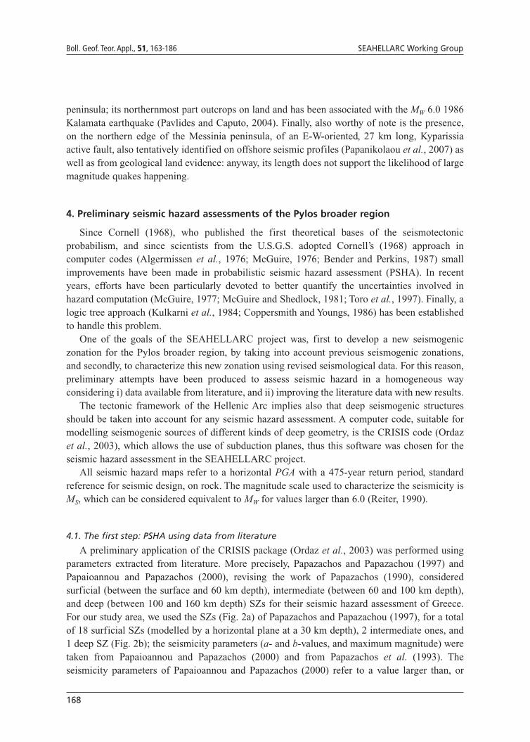
A preliminary application of the CRISIS package (Ordaz et al., 2003) was performed usingparameters extracted from literature. More precisely, Papazachos and Papazachou (1997) andPapaioannou and Papazachos (2000), revising the work of Papazachos (1990), consideredsurficial (between the surface and 60 km depth), intermediate (between 60 and 100 km depth),and deep (between 100 and 160 km depth) SZs for their seismic hazard assessment of Greece.For our study area, we used the SZs (Fig. 2a) of Papazachos and Papazachou (1997), for a totalof 18 surficial SZs (modelled by a horizontal plane at a 30 km depth), 2 intermediate ones, and1 deep SZ (Fig. 2b); the seismicity parameters (a- and b-values, and maximum magnitude) weretaken from Papaioannou and Papazachos (2000) and from Papazachos et al. (1993). Theseismicity parameters of Papaioannou and Papazachos (2000) refer to a value larger than, or
169
Preliminary seismic hazard assessments for the area of Pylos Boll. Geof. Teor. Appl., 51, 163-186
Fig. 2 - Seismogenic zonations from literature used for the preliminary PSHA: a) surficial SZs (from Papazachos andPapazachou, 1997); b) intermediate (D1 and D2) and deep (D5) SZs (modified from Papazachos and Papazachou,1997). The large square indicates the area of the SEAHELLARC earthquake catalogue, where SZs are defined; thesmall square identifies the area where seismic hazard has been assessed.
170
Boll. Geof. Teor. Appl., 51, 163-186 SEAHELLARC Working Group
equal to, 5 in a magnitude scale considered by the authors equivalent to MW; in our study they areconsidered equivalent to MS as a slight difference between the two scales would interest only thenarrow interval 5 to 6.
The choice of the attenuation relations required a specific analysis because of the way it istreated by the CRISIS code (Ordaz et al., 2003).
Several possible attenuation relations have been proposed for Greece (Theodulidis andPapazachos, 1992, 1994; Papazachos et al., 1993; Papaioannou and Papazachos, 2000; Margariset al., 2002; Skarlatoudis et al., 2003, 2004b). In particular, Papazachos et al. (1993) haveproposed different PGA attenuation relations for surficial, intermediate (along the axis of theHellenic Arc), and deep (inner part of the Hellenic Arc) earthquakes with reference to a stiff soil.These relations derive from a previous work by Theodulidis and Papazachos (1992), where asimilar relation was defined for rock and where the standard deviation, missing in Papazachos etal. (1993) study, was provided.
The CRISIS code (Ordaz et al., 2003) requires a table with PGA vs. epicentral (orhypocentral) distance values and then computes the site-to-source distance and takes the relatedattenuated PGA value. When using the epicentral distance, putting the SZ at the surface or atdepth makes no difference. Some tests that we did indicated that the Papazachos et al. (1993)relation for intermediate events refers to an average depth of 115 km while that for deep events,refers to an average depth of about 125 km; in the CRISIS code (Ordaz et al., 2003) they can besubstituted by the relation used for surficial events when the SZ is located at its actual depth.
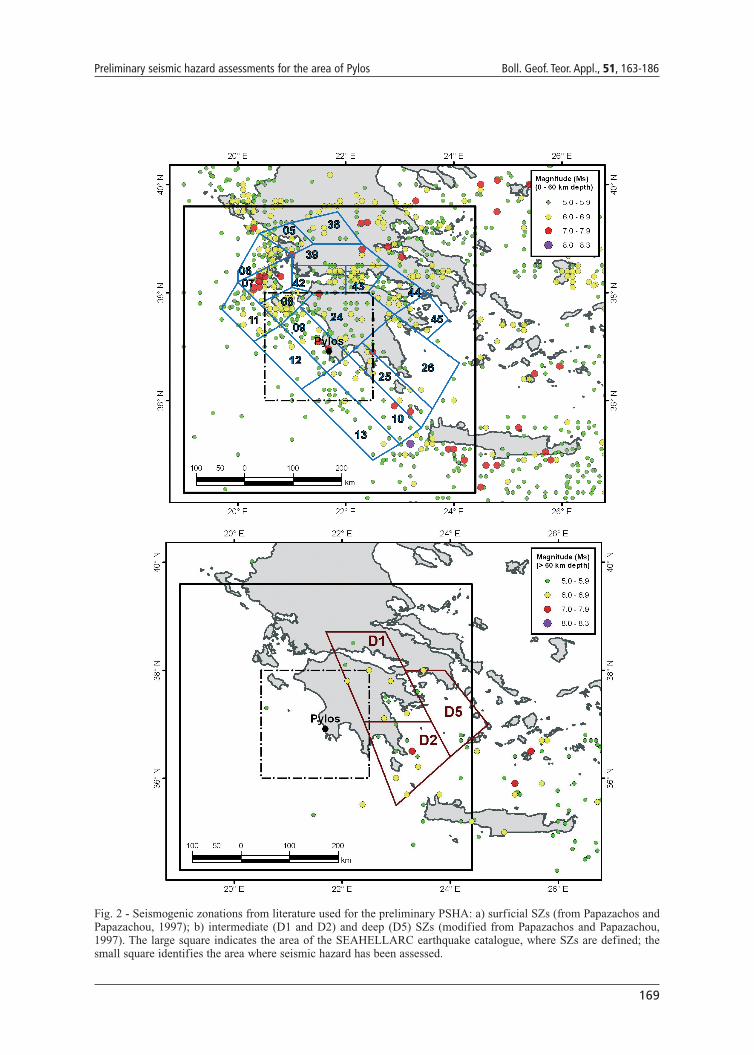
In the present work, the Theodulidis and Papazachos (1992) attenuation relation for surficialearthquakes (defined for events with a focal depth of less than, or equal to, 18 km) has been usedwith reference to rock. The hypocentral distance was considered for all the surficial, intermediate,and deep SZs, because these SZs are modelled with planes deeper than 20 km.
The resulting hazard map is shown on Fig. 3. It can be seen that Pylos and its neighbourhoodare characterized by PGA values between 0.56 and 0.64 g, while values exceeding 0.80 g areexpected on Zakinthos Island (in its northernmost part values larger than 0.88 g are evenforecasted).
Considering the test site of Pylos, Fig. 4 shows the complete seismic hazard curve, where it ispossible to observe that for a 475-year return period (annual exceedence probability of 0.0021)the expected ground motion is 0.63 g.
4.2. The second step: PSHA with seismogenic zonation derived from the literature and newseismicity data
Up to the mid 19th century, information on earthquakes came mainly from macroseismiceffects of large shocks. In 1911, a first seismometer was installed in Athens and since thenmodern seismometers have been operating continuously. In the 1950s, the first seismologicalstations of the permanent network were installed in Greece, and in the following decades the firsttelemetric network of seismological stations and the network of strong motion instruments wereestablished (Papazachos and Papazachou, 1997).
The catalogue used in the present study derives from three data files: (1) the historicalearthquake catalogue of Greece, which covers the period between 550 BC to 1963 (Papazachosand Papazachou, 1997), (2) the instrumental earthquake catalogue of Greece, which covers theperiod from 1964 to 2006, and (3) the recent earthquake locations from 2007 to April 2008. All
171
Preliminary seismic hazard assessments for the area of Pylos Boll. Geof. Teor. Appl., 51, 163-186
3 files were compiled at the National Observatory of Athens (NOA). All the main historicalevents from the catalogue were revised during the SEAHELLARC project by scientists fromNOA. Special investigations were carried out for strong earthquakes which occurred within a 300km distance from Pylos town.
The instrumental seismicity was also revised, and a lot of events were relocated, especially forthe last decade. All events in the catalogue contain a magnitude estimate according to the MS
scale. From 1911 to 1963 the magnitude was calculated at NOA using Mainka and Wiechertinstruments which belong to the intermediate period (~6-8 s) and therefore, provide a magnitudeequivalent to MS directly. After 1963, the local magnitude, ML, was determined from maximumamplitudes recorded by real Wood-Anderson instruments. The empirical formula MS = ML + 0.5(Papadopoulos, personal communication) has been used to transform ML into MS. We deduce thatthe catalogue is not homogeneous in the way that magnitude was estimated in the two periods:
Fig. 3 - Rock seismic hazard of the Pylos broader region in terms of PGA with a 475-year return period computed withdata from literature [Papazachos and Papazachou (1997) seismogenic zonation and Papaioannou and Papazachos(2000) seismicity parameters].

172
Boll. Geof. Teor. Appl., 51, 163-186 SEAHELLARC Working Group
before 1963 and after 1963.The resulting catalogue consists of 70,644 events that occurred from 550 BC to April 2008.
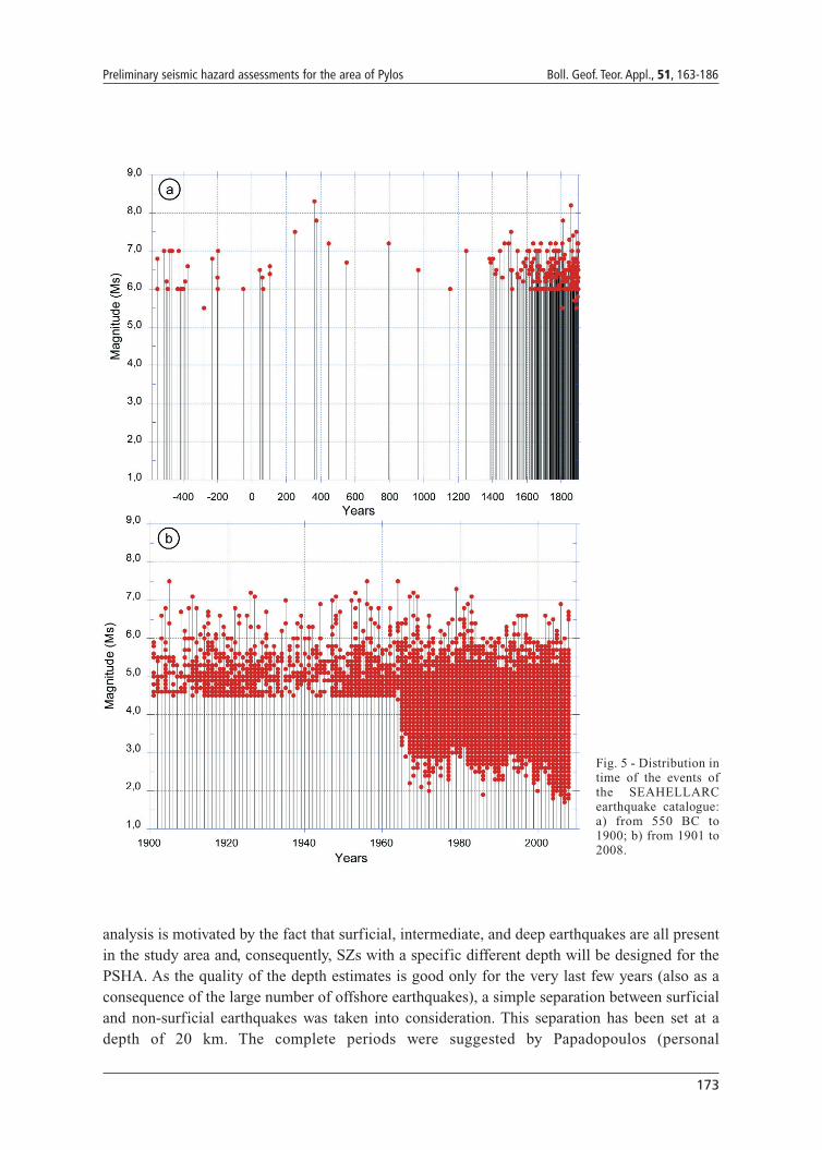
The minimum magnitude in the catalogue is MS 1.7, but the catalogue is extremely poor for eventsbefore 1400 (Fig. 5a), and almost only earthquakes characterized by a magnitude larger than 6are reported before 1800. An improvement of the data acquisition from 1900 is evident (Fig. 5b),but low magnitude events are reported only after 1964. The quality of the location also improvedwith time and acceptable depth estimates seem to be available only for the last few decades.
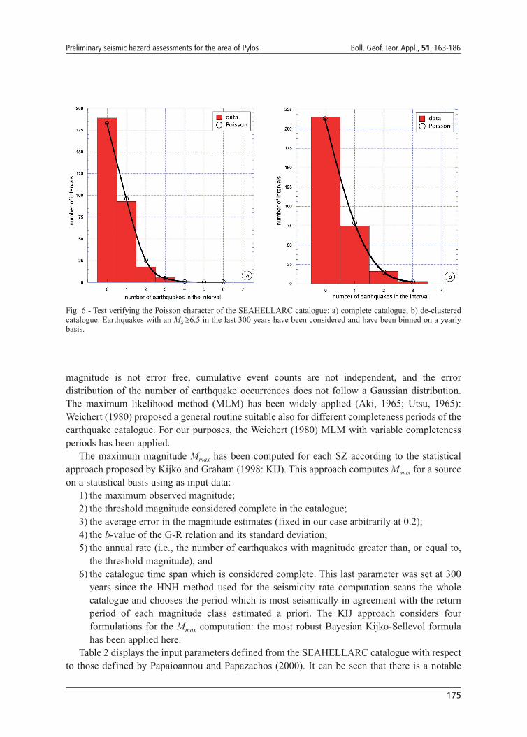
The first step in compiling an earthquake catalogue, in view of its use for a seismic hazardassessment following Cornell’s (1968) approach, is to eliminate foreshocks and aftershocks. Inthe present study, the removal of the dependent events was done according to the Gardner andKnopoff (1974) approach: i.e., by applying a space - time window calibrated on Greek seismicsequences (Latoussakis and Stavrakakis, 1992). In such a way, 31,518 dependent events wereeliminated from the catalogue and the final data file used for hazard estimates (hereafterSEAHELLARC catalogue) include 39,126 events with an MS larger than 1.7. A test has beenperformed to verify that the declustered catalogue obtained, follows a Poisson distribution. Wehave considered events with an MW larger than, or equal to, 6.5, for which the catalogue hadenough documentation covering the last 300 years. One-year intervals have been considered andthe events in each interval have been counted. The resulting value of the χ2-test [accepted test forbinned distributions (Press et al., 1992)] is equal to 0.77, corresponding to a significance level of85% (Fig. 6b). The complete catalogue, conversely, failed to pass the same χ2-test (Fig. 6a).
A separate analysis has interested the completeness of the surficial events in theSEAHELLARC catalogue as distinguished from the intermediate and deep ones. This distinct
Fig. 4 - Seismic hazard curve for thetown of Pylos. The short dashed linerepresents the results obtained throughliterature data (Papazachos andPapazachou, 1997; Papaioannou andPapazachos, 2000); the long dashedline shows the results with theSEAHELLARC earthquake catalogueand the Papazachos and Papazachou(1997) seismogenic zonation; the solidline indicates the results with theSEAHELLARC catalogue andzonation.
173
Preliminary seismic hazard assessments for the area of Pylos Boll. Geof. Teor. Appl., 51, 163-186
analysis is motivated by the fact that surficial, intermediate, and deep earthquakes are all presentin the study area and, consequently, SZs with a specific different depth will be designed for thePSHA. As the quality of the depth estimates is good only for the very last few years (also as aconsequence of the large number of offshore earthquakes), a simple separation between surficialand non-surficial earthquakes was taken into consideration. This separation has been set at adepth of 20 km. The complete periods were suggested by Papadopoulos (personal
Fig. 5 - Distribution intime of the events ofthe SEAHELLARCearthquake catalogue:a) from 550 BC to1900; b) from 1901 to2008.
174
Boll. Geof. Teor. Appl., 51, 163-186 SEAHELLARC Working Group
communication) for the surficial seismicity, while they were taken from Skarlatoudis et al.(2004a) for the deep events. Both sets of completeness periods were checked by Stepp (1972)graphs. This check was done by analyzing the cumulative number of events in each magnitudeclass, according to the selected 0.5 step, vs. time from present. The change of the slope from alinear trend identifies the dates when the catalogue starts being documented in a worse way. So,the completeness of the catalogue for the different magnitude classes remains identified (Table1). To be correct, it should be stated that the periods singled out represent intervals when theseismicity is stationary in time but the stationarity of the seismic process is a working hypothesisin PSHA and, consequently, stationarity and completeness can be considered equivalent. Longperiods of completeness refer only to large magnitude classes (6.5 and larger) and thecompleteness of almost all the other classes is limited to the last century.
A second computation was then produced, considering again the Papazachos and Papazachou(1997) seismogenic zonation and the SEAHELLARC catalogue, instead of taking the seismicityparameters directly from Papaioannou and Papazachos (2000).
For the seismic hazard assessment [according to the Cornell (1968) approach], the seismicityof each SZ is described by the a- and b-values of the Gutenberg-Richter (G-R) relation and bythe value of the maximum magnitude.
Individual seismicity rates have been computed following the “higher not highest” (HNH)method developed for the seismic hazard map of the Italian territory (Slejko et al., 1998) in termsof MS. The scaling law between magnitude MS and moment M0 is not linear from low to highvalues, and two linear branches have been proposed with a changing point around 6.4 (Reiter,1990). This fact affects the b-value estimates when MS is considered instead of MW. Anyway, theshift should be very limited (Ambraseys, 2003) and so can be not taken into account in the b-value estimation.
Different methodologies for assessing the b-value of the G-R relation are available inliterature. The least-squares method (LSM) is often used, although not formally suitable since
MSShallow events
(h ≤ 20 km)
Int. & deepevents
(h >20 km)
3.0 – 3.4 1978 1978
3.5 – 3.9 1978 1978
4.0 – 4.4 1968 1978
4.5 – 4.9 1963 1978
5.0 – 5.4 1908 1968
5.5 – 5.9 1908 1968
6.0 – 6.4 1908 1908
6.5 – 6.9 1858 1908
7.0 – 7.4 1758 1848
7.5 – 8.0 1608 1808
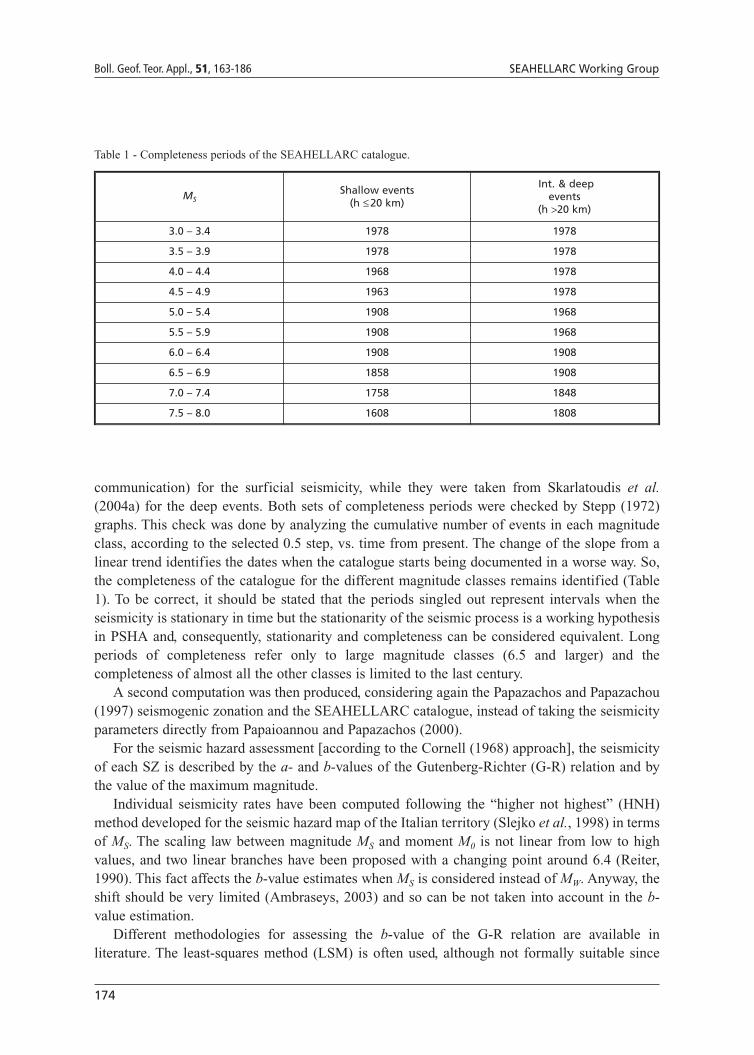
Table 1 - Completeness periods of the SEAHELLARC catalogue.
175
Preliminary seismic hazard assessments for the area of Pylos Boll. Geof. Teor. Appl., 51, 163-186
magnitude is not error free, cumulative event counts are not independent, and the errordistribution of the number of earthquake occurrences does not follow a Gaussian distribution.The maximum likelihood method (MLM) has been widely applied (Aki, 1965; Utsu, 1965):Weichert (1980) proposed a general routine suitable also for different completeness periods of theearthquake catalogue. For our purposes, the Weichert (1980) MLM with variable completenessperiods has been applied.
The maximum magnitude Mmax has been computed for each SZ according to the statisticalapproach proposed by Kijko and Graham (1998: KIJ). This approach computes Mmax for a sourceon a statistical basis using as input data:
1) the maximum observed magnitude; 2) the threshold magnitude considered complete in the catalogue; 3) the average error in the magnitude estimates (fixed in our case arbitrarily at 0.2); 4) the b-value of the G-R relation and its standard deviation; 5) the annual rate (i.e., the number of earthquakes with magnitude greater than, or equal to,
the threshold magnitude); and 6) the catalogue time span which is considered complete. This last parameter was set at 300
years since the HNH method used for the seismicity rate computation scans the wholecatalogue and chooses the period which is most seismically in agreement with the returnperiod of each magnitude class estimated a priori. The KIJ approach considers fourformulations for the Mmax computation: the most robust Bayesian Kijko-Sellevol formulahas been applied here.
Table 2 displays the input parameters defined from the SEAHELLARC catalogue with respectto those defined by Papaioannou and Papazachos (2000). It can be seen that there is a notable
Fig. 6 - Test verifying the Poisson character of the SEAHELLARC catalogue: a) complete catalogue; b) de-clusteredcatalogue. Earthquakes with an MS ≥6.5 in the last 300 years have been considered and have been binned on a yearlybasis.
176
Boll. Geof. Teor. Appl., 51, 163-186 SEAHELLARC Working Group
decrease in the seismicity rate for all SZs with the exception of SZs 12, 13, and 24. Conversely,the new b-values show a general increase for almost all SZs, even exceeding the value of 1.0 forseveral SZs. The new maximum magnitude Mmax differs in almost all cases with respect to that ofPapaioannou and Papazachos (2000), but no general tendency can be observed. As the methodfollowed by Papaioannou and Papazachos (2000) is not declared, it is not possible to justify thisdifference.
As in the previous attempt (Fig. 3), the Theodulidis and Papazachos (1992) attenuationrelation for surficial events has been applied to all (surficial, intermediate, and deep) SZs,considering the hypocentral distance.
Fig. 7 shows the seismic hazard obtained with these new seismicity data. The map showslower values than the previous one (Fig. 3), and Pylos is now characterized by a PGA between0.48 and 0.56 g. The largest ground motions are found, again, in Zakinthos Island with valueslarger than 0.64 g.
Considering the test site of Pylos, the complete seismic hazard curve (Fig. 4) displays an expectedground motion of 0.53 g for the 475-year return period (annual exceedence probability of 0.0021).
Table 2 - Seismicity parameters from Papaioannou and Papazachos (2000) and computed from the SEAHELLARCcatalogue. λ5 is the number of earthquakes with an MS larger than, or equal to, 5.0. Mmax is the maximum magnitudewhile Mmaxo is the maximum observed magnitude. For the number of SZs refer to Fig. 2.
Zone Papaioannou and Papazachos (2000) From SEAHELLARC catalogue
λλ5 b Mmax λλ5 b Mmaxo Mmax
5 0.922 0.96 6.9 0.333 1.05 6.5 6.5
6 1.286 0.99 7.1 0.731 0.89 6.7 6.7
7 2.697 0.99 7.3 1.126 0.95 7.4 7.4
8 1.258 0.99 7.1 1.018 0.97 6.8 6.8
9 0.960 0.98 7.2 0.778 1.09 7.5 7.7
10 0.476 0.97 7.1 0.377 1.32 7.0 7.2
11 1.200 1.02 7.1 0.972 0.97 6.6 6.7
12 0.282 1.00 6.4 0.482 1.30 6.5 6.5
13 0.451 0.99 6.3 0.684 1.28 6.2 6.2
24 0.522 0.95 6.9 0.617 1.18 7.0 7.1
25 0.602 0.96 7.2 0.241 1.14 7.2 7.3
26 0.184 0.95 6.8 0.187 1.28 6.5 6.6
38 0.503 0.93 6.8 0.153 1.25 6.5 6.7
39 0.464 0.94 7.0 0.234 1.29 7.0 7.2
42 0.560 0.96 6.8 0.498 1.12 6.8 6.8
43 1.076 0.94 7.0 0.362 1.15 6.8 6.8
44 0.953 0.92 7.0 0.336 0.98 6.8 6.8
45 0.271 0.92 6.5 0.061 1.05 6.3 6.8
D1 0.302 0.56 7.5 0.271 0.59 7.2 7.5
D2 0.100 0.56 7.5 0.052 0.63 6.9 7.3
D5 0.100 0.75 7.0 0.059 0.70 6.3 6.8
177
Preliminary seismic hazard assessments for the area of Pylos Boll. Geof. Teor. Appl., 51, 163-186
4.3. The third step: PSHA using a new seismogenic zonation and new seismicity data
The final seismic hazard assessment will consider different hypotheses for the seismogeniczonation, for maximum magnitude and seismic activity, and for the attenuation model. At the presentstage of research, we show the result based on a new seismogenic zonation for the Pylos region,which integrates the results obtained by the national zonation (Fig. 7).
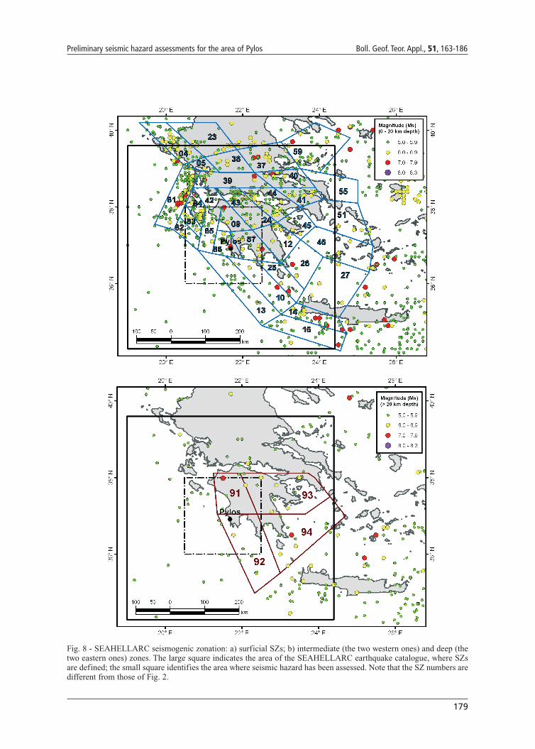
On the basis of a comprehensive analysis of Greek seismicity and considering the geophysicalinformation available for the region, a new seismogenic zonation has been designed. Thiszonation is totally new for the Pylos region (compare Figs. 2a and 8a), while outside, it is onlymodified from Papazachos and Papazachou (1997) for the surficial zones. The intermediate anddeep SZs are also modified (Fig. 8b) from those of Papazachos and Papazachou (1997). Moreprecisely, it was decided to separate the surficial seismicity (depth less than or equal to 20 km)from the rest. The geometry of the intermediate and deep SZs of Papazachos and Papazachou
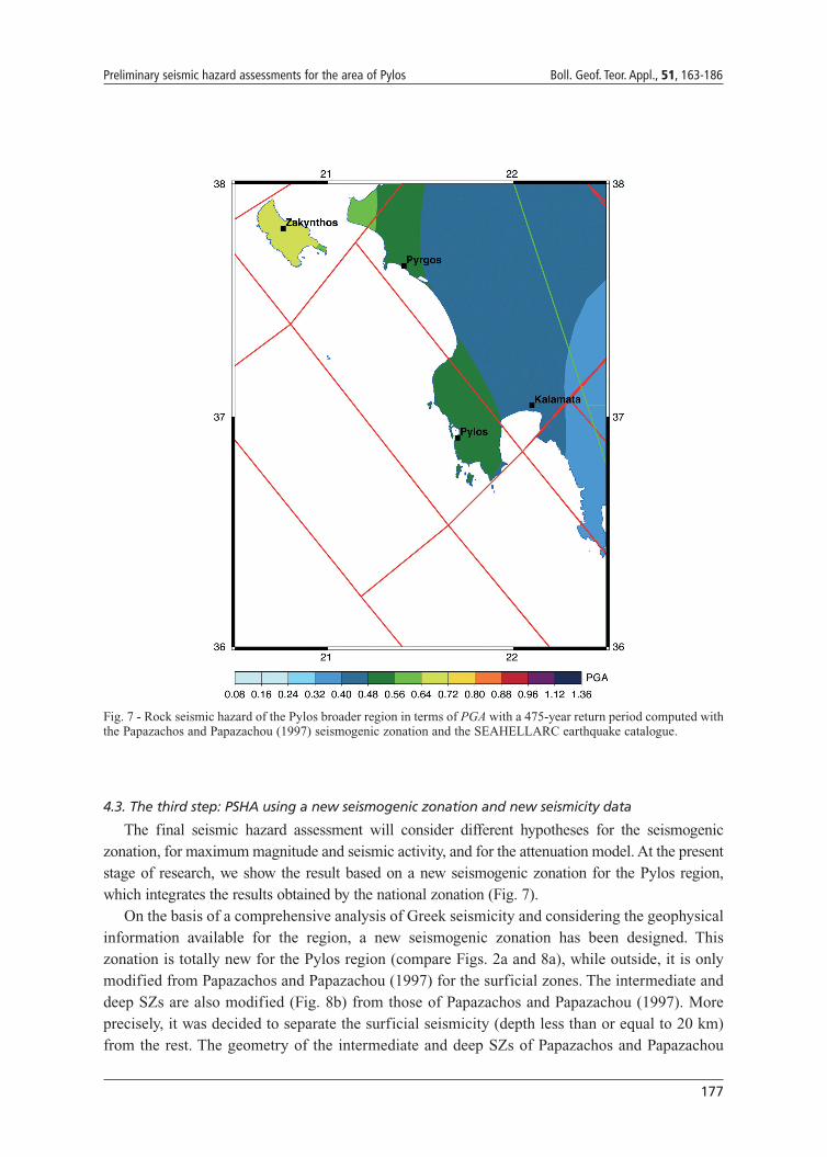
Fig. 7 - Rock seismic hazard of the Pylos broader region in terms of PGA with a 475-year return period computed withthe Papazachos and Papazachou (1997) seismogenic zonation and the SEAHELLARC earthquake catalogue.
178
Boll. Geof. Teor. Appl., 51, 163-186 SEAHELLARC Working Group
(1997) have been modified in agreement with the geometry of the subduction plane as proposedby Papazachos et al. (2000), whose western limb is located offshore the Peloponnese, and theaccepted evidence of a dip of about 35° for this subduction plane (Papazachos et al., 2000). Twointermediate SZs have been designed between a depth of 20 and 60 km, and two deep SZs froma 60 km depth downwards, as far as 160 km (Fig. 8b).
In short, 37 SZs were used for hazard computation: 33 are shallow (modelled by a horizontalplane at a 10 km depth), 2 are intermediate, and 2 are deep. The general trend reflecting thegeometry of the Hellenic Arc, clearly evident in the national zonation (Fig. 2a), is still present inthe surficial zonation (Fig. 8a) but two transverse SZs are introduced for the modelling of themajor dextral transcurrent fault systems of the region: the Cephalonia and the Andravida faults[see also Slejko et al. (1999)]. The rest of the zonation reflects the national zonation with therequired modifications. The agreement between the hypocentral distribution and the zonation isillustrated in Fig. 8. Surficial earthquakes occurred in the whole of the study region, and thisjustifies the presence of the surficial SZs in almost all the area.
The seismic hazard assessment has been performed in the same way as that of the previousattempt (Fig. 7), that is with the HNH method for seismicity rate computation in terms of MS, theMLM for the b-value assessment, and the KIJ method for the Mmax estimation (Table 3).
As in the previous runs (Figs. 3 and 7), the Theodulidis and Papazachos (1992) attenuationrelation for surficial events has been applied to all (surficial, intermediate, and deep) SZs,considering the hypocentral distance for all the SZs.
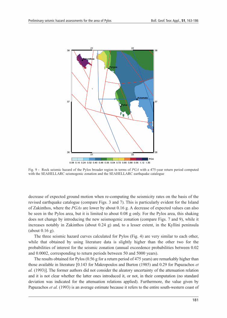
Fig. 9 shows the hazard results as derived from this new seismogenic zonation. It can beobserved that slightly higher ground motions than the previous elaboration (Fig. 7) are forecastalmost everywhere, with the exception of the area of Kalamata (Fig. 7). The highest groundshaking is again reached on the Island of Zakinthos (PGA values larger than 0.96 g almosteverywhere) and in the Kyllini peninsula (PGA values larger than 0.80 g in the westernmoststrip). Ground motions between 0.56 and 0.64 g characterize the coast around Pylos.
In considering the test site of Pylos, the complete seismic hazard curve (Fig. 4) displays anexpected ground motion of 0.56 g for a 475-year return period (annual exceedence probability of0.0021).
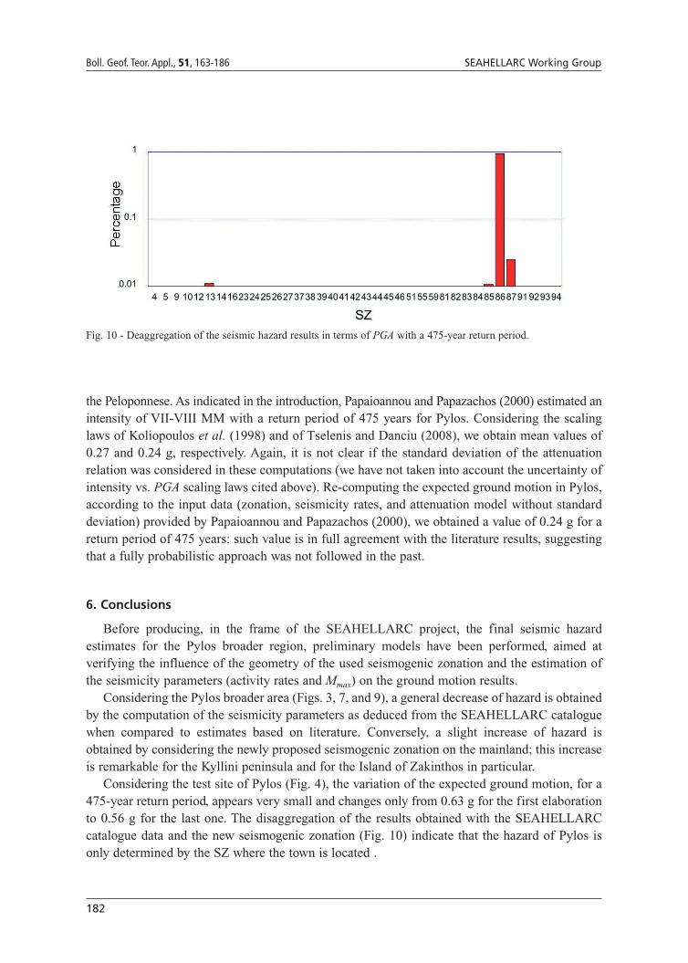
The results of this last elaboration for the site of Pylos have been disaggregated (McGuire,1995; Bazzurro and Cornell, 1999; Harmsen et al., 1999; Harmsen and Frankel, 2001) to identifythe origin of the main contribution to hazard. Fig. 10 clearly illustrates that only 4 SZs, of whichSZ 86 has the largest impact, contribute with 94%. Although the seismicity of SZ 86 is not veryhigh (see Table 3), this result is quite obvious since Pylos is located within SZ 86. Similarcontributions, varying between 1% to 2%, are provided by SZs 13, 85, and 87. All these SZs areadjacent to SZ 86 and are similarly surficial. It is worth noting that only the SZs near Pyloscontribute to its hazard, while the SZs situated far away, even if very active, such as SZ 81Cephalonia, have no influence on the area.
5. Considerations on the preliminary seismic hazard assessments for the Pylosbroader region
When comparing the three maps (Figs. 3, 7, and 9), one can see that there is an evident
179
Preliminary seismic hazard assessments for the area of Pylos Boll. Geof. Teor. Appl., 51, 163-186
Fig. 8 - SEAHELLARC seismogenic zonation: a) surficial SZs; b) intermediate (the two western ones) and deep (thetwo eastern ones) zones. The large square indicates the area of the SEAHELLARC earthquake catalogue, where SZsare defined; the small square identifies the area where seismic hazard has been assessed. Note that the SZ numbers aredifferent from those of Fig. 2.

180
Boll. Geof. Teor. Appl., 51, 163-186 SEAHELLARC Working Group
Table 3 - Seismicity parameters for the SEAHELLARC zonation computed from the SEAHELLARC catalogue. λ5 isthe number of earthquakes with an MS larger than, or equal to, 5.0. Mmax is the maximum magnitude while Mmaxo is themaximum observed magnitude. For the number of SZs refer to Fig. 8.
SZ λλ5 b Mmaxo Mmax
SZ_04 0.97 0.91 5.8 5.9
SZ_05 0.08 1.00 6.1 6.1
SZ_09 0.12 1.49 5.8 5.8
SZ_10 0.39 1.28 6.1 6.1
SZ_12 0.08 1.26 5.5 5.6
SZ_13 0.60 1.25 6.0 6.2
SZ_14 0.30 1.07 6.3 6.3
SZ_16 0.45 0.90 7.0 7.0
SZ_23 0.34 1.06 6.1 6.1
SZ_24 0.13 1.11 6.5 6.
SZ_25 0.07 1.65 6.0 6.1
SZ_27 0.04 1.51 5.5 5.5
SZ_26 0.08 1.52 5.5 5.5
SZ_37 0.26 1.16 7.0 7.0
SZ_38 0.14 1.51 6.5 6.5
SZ_39 0.19 1.33 6.5 6.5
SZ_40 0.24 1.05 5.8 5.9
SZ_41 0.15 0.96 6.0 6.1
SZ_42 0.07 1.38 6.3 6.3
SZ_43 0.35 1.43 6.0 6.1
SZ_44 0.43 1.11 6.8 6.8
SZ_45 0.04 1.12 5.5 5.6
SZ_46 0.11 0.99 6.1 6.1
SZ_51 0.05 0.91 5.4 5.5
SZ_55 0.07 1.25 5.8 5.8
SZ_59 0.45 0.97 7.0 7.1
SZ_81 1.64 0.90 6.7 6.7
SZ_82 0.37 0.91 6.6 6.6
SZ_83 0.33 1.22 6.8 6.8
SZ_84 0.50 1.01 7.2 7.2
SZ_85 0.46 1.13 6.? 6.2
SZ_86 0.23 1.35 6.9 7.0
SZ_87 0.13 1.34 6.0 6.0
SZ_91 0.13 1.33 5.5 5.5
SZ_92 0.26 1.34 5.2 5.2
SZ_93 0.27 1.15 7.2 7.3
SZ_94 0.20 1.10 7.2 7.3
181
Preliminary seismic hazard assessments for the area of Pylos Boll. Geof. Teor. Appl., 51, 163-186
decrease of expected ground motion when re-computing the seismicity rates on the basis of therevised earthquake catalogue (compare Figs. 3 and 7). This is particularly evident for the Islandof Zakinthos, where the PGAs are lower by about 0.16 g. A decrease of expected values can alsobe seen in the Pylos area, but it is limited to about 0.08 g only. For the Pylos area, this shakingdoes not change by introducing the new seismogenic zonation (compare Figs. 7 and 9), while itincreases notably in Zakinthos (about 0.24 g) and, to a lesser extent, in the Kyllini peninsula(about 0.16 g).
The three seismic hazard curves calculated for Pylos (Fig. 4) are very similar to each other,while that obtained by using literature data is slightly higher than the other two for theprobabilities of interest for the seismic zonation (annual exceedence probabilities between 0.02and 0.0002, corresponding to return periods between 50 and 5000 years).
The results obtained for Pylos (0.56 g for a return period of 475 years) are remarkably higher thanthose available in literature [0.143 for Makropoulos and Burton (1985) and 0.29 for Papazachos etal. (1993)]. The former authors did not consider the aleatory uncertainty of the attenuation relationand it is not clear whether the latter ones introduced it, or not, in their computation (no standarddeviation was indicated for the attenuation relations applied). Furthermore, the value given byPapazachos et al. (1993) is an average estimate because it refers to the entire south-western coast of
Fig. 9 - Rock seismic hazard of the Pylos broader region in terms of PGA with a 475-year return period computedwith the SEAHELLARC seismogenic zonation and the SEAHELLARC earthquake catalogue
182
Boll. Geof. Teor. Appl., 51, 163-186 SEAHELLARC Working Group
the Peloponnese. As indicated in the introduction, Papaioannou and Papazachos (2000) estimated anintensity of VII-VIII MM with a return period of 475 years for Pylos. Considering the scalinglaws of Koliopoulos et al. (1998) and of Tselenis and Danciu (2008), we obtain mean values of0.27 and 0.24 g, respectively. Again, it is not clear if the standard deviation of the attenuationrelation was considered in these computations (we have not taken into account the uncertainty ofintensity vs. PGA scaling laws cited above). Re-computing the expected ground motion in Pylos,according to the input data (zonation, seismicity rates, and attenuation model without standarddeviation) provided by Papaioannou and Papazachos (2000), we obtained a value of 0.24 g for areturn period of 475 years: such value is in full agreement with the literature results, suggestingthat a fully probabilistic approach was not followed in the past.
6. Conclusions
Before producing, in the frame of the SEAHELLARC project, the final seismic hazardestimates for the Pylos broader region, preliminary models have been performed, aimed atverifying the influence of the geometry of the used seismogenic zonation and the estimation ofthe seismicity parameters (activity rates and Mmax) on the ground motion results.
Considering the Pylos broader area (Figs. 3, 7, and 9), a general decrease of hazard is obtainedby the computation of the seismicity parameters as deduced from the SEAHELLARC cataloguewhen compared to estimates based on literature. Conversely, a slight increase of hazard isobtained by considering the newly proposed seismogenic zonation on the mainland; this increaseis remarkable for the Kyllini peninsula and for the Island of Zakinthos in particular.
Considering the test site of Pylos (Fig. 4), the variation of the expected ground motion, for a475-year return period, appears very small and changes only from 0.63 g for the first elaborationto 0.56 g for the last one. The disaggregation of the results obtained with the SEAHELLARCcatalogue data and the new seismogenic zonation (Fig. 10) indicate that the hazard of Pylos isonly determined by the SZ where the town is located .
Fig. 10 - Deaggregation of the seismic hazard results in terms of PGA with a 475-year return period.
183
Preliminary seismic hazard assessments for the area of Pylos Boll. Geof. Teor. Appl., 51, 163-186
Acknowledgements. The SEAHELLARC project (contract n. 037004) is financed by the 6th FrameworkProgramme on Research, Technological Development and Demostration of the European Commission andis co-ordinated by Joanna Papoulia, Hellenic Centre for Marine Research, Anavissos Attiki, Greece. Mostof the figures were produced using the Generic Mapping Tool (GMT) software package (Wessel and Smith,1991). Many thanks are due to Angelo Masi and Marco Mucciarelli, both at the Basilicata University, forreviewing the manuscript suggesting important improvements. Fabio Cavallini, OGS, helped us with somestatistical tests.
REFERENCES
Aki K.; 1965: Maximum likelihood estimate of b in the formula logN=a-bM and its confidence limits. Bull. Earth. Res.Inst., 43, 237-239.
Algermissen S.T., Perkins D.M., Isherwood W., Gordon D., Reagor G. and Howard C.; 1976: Seismic risk evaluationof the Balkan region. In: Karnik V. and Radu C. (eds), Proceedings of the Seminar on Seismic Zoning Maps, Vol.2, Unesco, Skopje, pp. 172-240.
Ambraseys N.N.; 2003: Reappraisal of magnitude of 20th century earthquakes in Switzerland. J. Earthq. Eng., 7, 149-191.
Baker C., Hatzfeld D., Lyon-Caen H., Papadimitriou E. and Rigo A.; 1997: Earthquake mechanisms of the Adriatic Seaand Western Greece: implications for the oceanic subduction-continental collision transition. Geoph. J. Int., 131,559-594.
Bazzurro P. and Cornell C.A.; 1999: Disaggregation of seismic hazard. Bull. Seism. Soc. Am., 89, 501-520.
Bender B. and Perkins D.M.; 1987: Seisrisk III: a computer program for seimic hazard estimation. Bulletin 1772, U.S.Geological Survey, Denver, 48 pp.
Benetatos C., Dreger D. and Kiratzi A.; 2007: Complex and segmented rupture associated with the 14 August 2003 Mw6.2 Lefkada, Ionian Islands, earthquake. Bull. Seism. Soc. Am., 97, 35-51.
Coppersmith K.J. and Youngs R.R.; 1986: Capturing uncertainty in probabilistic seismic hazard assessments withinintraplate environments. In: Proceedings of the Third U.S. National Conference on Earthquake Engineering,August 24-28, 1986, Charleston, SC, Earthquake Engineering Research Institute, El Cerrito CA U.S.A., Vol. 1, pp.301-312.
Cornell C.A.; 1968: Engineering seismic risk analysis. Bull. Seism. Soc. Am., 58, 1583-1606.
Fountoulis I.; 1994: Neotectonic evolution of central-western Peloponnese, Greece. PhD Thesis, University of Athens,Faculty of Geology, Department of Dynamic Tectonic Applied Geology, GAIA 7, 386 pp. (in Greek with abridgedEnglish version).
Galanopoulos A.G.; 1949: The Koroni (Messinia) earthquake of October 6, 1947. Bull. Seism. Soc. Am., 39, 33-39.
Gardner J.K. and Knopoff L.; 1974: Is the sequence of earthquakes in southern California, with aftershocks removed,Poissonian? Bull. Seism. Soc. Am., 64, 1363-1367.
Harmsen S. and Frankel A.; 2001: Geographic deaggregation of seismic hazard in the United States. Bull. Seism. Soc.Am., 91, 13-26.
Harmsen S., Perkins D. and Frankel A.; 1999: Deaggregation of probabilistic ground motions in the Central andEastern United States. Bull. Seism. Soc. Am., 89, 1-13.
Jiménez M.J., Giardini G., Grünthal G. and the SESAME Working Group; 2001: Unified seismic hazard modellingthroughout the Mediterranean region. Boll. Geof. Teor. Appl., 42, 3-18.
Jiménez M.J., Giardini D. and Grünthal G.; 2003: The ESC-SESAME unified hazard model for the European-

184
Boll. Geof. Teor. Appl., 51, 163-186 SEAHELLARC Working Group
Mediterranean region. EMSC/CSEM Newsletter, 19, 2-4.
Karakostas V.G., Papadimitriou E.E. and Papazachos C.B.; 2004: Properties of the 2003 Lefkada, Ionian Islands,Greece, earthquake seismic sequence and seismicity triggering. Bull. Seism. Soc. Am., 94, 1976–1981.
Kijko A. and Graham G.; 1998: Parametric-historic procedure for probabilistic seismic hazard analysis. Part I:estimation of maximum regional magnitude mmax. Pure Appl. Geophys., 152, 413-442.
Koliopoulos P.K., Margaris B.N. and Klimis N.S.; 1998: Duration and energy characteristics of Greek strong motionrecords. J. Earth. Eng., 2, 391-417.
Koukouvelas I.K., Kokkalas S. and Xypolias P.; 2009: Surface deformation during the MW 6.4 (8 June 2008) MovriMountain earthquake in the Peloponnese, and its implications for the seismotectonics of western Greece. Internat.Geol. Review, doi: 10.1080/00206810802674329.
Kulkarni R.B., Youngs R.R. and Coppersmith K.J.; 1984: Assessment of confidence intervals for results of seismichazard analysis. In: Proceedings of the Eighth World Conference on Earthquake Engineering, July 21-28, 1984,San Francisco CA U.S.A., Prentice-Hall Inc., Englewood Cliffs NJ U.S.A., Vol. 1, pp. 263-270.
Latoussakis J. and Stavrakakis G.N.; 1992: Times of increased probability of earthquakes of ML ? 5.5 in Greecediagnosed by algorithm M8. Tectonophysics, 210, 315-326.
Louvari E.K., Kiratzi A.A. and Papazachos B.C.; 1999: The Cephalonia transform fault and its extension to westernLefkada island (Greece). Tectonophysics, 308, 223-236.
Makris J. and Papoulia J.; 2009: Tectonic evolution of Zakinthos island from deep seismic soundings: thrusting and itsassociation with the Triassic evaporates. Intl. Symposium and Field trip Evaporites: Sedimentology, Evaluationand Economic Significance, Zakinthos, Greece, pp. 47-54.
Makropoulos K.C. and Burton P.W.; 1985: Seismic hazard in Greece. II. Ground acceleration. Tectonophysics, 117,259-294.
Margaris B., Papazachos C., Papaioannou C., Theodulidis N., Kalogeras I. and Skarlatoudis A.; 2002: Ground motionattenuation relations for shallow earthquakes in Greece. In: DipTeRis, European Seismological Commission(ESC) XXVIII General Assembly, Book of Abstracts, STUDIO64srl, Genova, pp. 128.
Mariolakos I. and Papanikolau D.; 1981: The neogene basins of the Aegean Arc from the Paleogeographic and theGeodynamic point of view. In: Proceedings, Int. Symp. Hell. Arc and Trench (HEAT), I, Athens, pp. 383-399.
McGuire R.K.; 1976: Fortran computer program for seismic risk analysis. U.S.G.S.. Open File Report, 76-67, 92 pp.
McGuire R.K.; 1977: Effects of uncertainties in seismicity on estimates of seismic hazard for the east coast of theUnited States. Bull. Seism. Soc. Am., 67, 827-848.
McGuire R.K.; 1995: Probabilistic seismic hazard analysis and design earthquakes: closing the loop. Bull. Seism. Soc.Am., 85, 1275-1284.
McGuire R.K. and Shedlock K.M.; 1981: Statistical uncertainties in seismic hazard evaluations in the United States.Bull. Seism. Soc. Am., 71, 1287-1308.
Ordaz M., Aguilar A. and Arboleda J.; 2003: CRISIS03 Program for computing seismic hazard. UNAM, Mexico.
Papadimitriou P., Kaviris G. and Makropoulos K.; 2006: The MW=6.3 2003 Lefkada earthquake (Greece) and inducesstress transfer changes. Tectonophysics, 423, 73-82.
Papadopoulos G.A. and Kijko A.; 1991: Maximum likelihood estimation of earthquake hazard parameters in theAegean area from mixed data. Tectonophysics, 185, 277-294.
Papadopoulos G., Karastathis V., Ganas A., Pavlides S., Fokaefs A. and Orfanogiannaki K.; 2003: The Lefkada, IonianSea (Greece), shock (MW6.2) of 14 August 2003: evidence for the characteristic earthquake model from seismicityand ground failures. Earth Planets Space, 55, 713-718.
Papadopoulos G., Daskalaki E., Fokaefs A. and Giraleas N.; 2010: Tsunami hazard in the Eastern Mediterranean sea:strong earthquakes and tsunamis in the west Hellenic arc and trench system. J. of Earthquakes and Tsunami, inpress.
Papaioannou C.A. and Papazachos B.C.; 2000: Time-independent and time-dependent seismic hazard in Greece basedon seismogenic sources. Bull. Seism. Soc. Am., 90, 22-33.
Papanikolaou D., Fountoulis I. and Metaxas C.; 2007: Active faults, deformation rates and Quaternary paleogeographyat Kiparissiakos Gulf (SW Greece) deduced from onshore and offshore data. Quaternary International, 171-172,14-30.
185
Preliminary seismic hazard assessments for the area of Pylos Boll. Geof. Teor. Appl., 51, 163-186
Papazachos B.C.; 1990: Seismicity of the Aegean and surrounding area. Tectonophysics, 178, 287-308.
Papazachos B.C. and Papazachou C.B.; 1997: The earthquakes of Greece. Ziti Publications, Thessaloniki, 304 pp.
Papazachos B.C., Papaioannou C.A., Margaris B.N. and Theodulidis N.P.; 1993: Regionalization of seismic hazard inGreece based on seismic sources. Natural Hazards, 8, 1-18.
Papazachos B.C., Karakostas V.G., Papazachos C.B. and Scordilis E.M.; 2000: The geometry of the Wadati – Benioffzone and lithosheric Kinematics in the Hellenic arc. Tectonophysics, 319, 275-300.
Papazachos C.B., Karakaisis G.F., Scordilis E.M. and Papazachos B.C.; 2004: Probabilities of activation of seismicfaults in critical regions of the Aegean area. Geophys. J. Int., 159, 679–687.
Papoulia J.E. and Stavrakakis G.N.; 1995: Seismic hazard parameters estimation in Greece and the surrounding areabased on historical and instrumental data. Boll. Geof. Teor. Appl., 37, 315-322.
Papoulia J. and Slejko D.; 1997: Seismic hazard assessment in the Ionian islands based on observed macroseismicintensities. Natural Hazards, 14, 179-187.
Papoulia J., Stavrakakis G. and Papanikolaou D.; 2001: Bayesian estimation of strong earthquakes in the InnerMessiniakos fault zone, southern Greece, based on seismological and geological data. J. Seismology, 5, 233-242.
Pavlides S. and Caputo R.; 2004: Magnitude versus faults’ surface parameters: quantitative relationships from theAegean region. Tectonophysics, 380, 159-188.
Press W.H., Teukolsky S.A., Vetterling W.T. and Flannery B.P.; 1992: Numerical recipes in Fortran - the art of scientificcomputing. Second edition. Cambridge University Press, Cambridge MA, 963 pp.
Reiter L.; 1990: Earthquake hazard analysis: issues and insights. Columbia University Press, New York, 252 pp.
Sachpazi M., Hirn A., Clement C., Haslinger F., Laigle M., Kissling E., Charvis P., Hello Y., Lepine J.C., Sapin M. andAnsorge J.; 2000: Western Hellenic subduction and Cephalonia Transform: local earthquakes and plate transportand strain. Tectonophysics, 319, 301-319.
SEAHELLARC Working Group; 2008: Preliminary seismic hazard assessment for the Pylos region (SW Hellenic Arc).In: Slejko D., Riggio A. and Santulin M. (eds), Gruppo Nazionale di Geofisica della Terra Solida, 27° ConvegnoNazionale - Riassunti Estesi delle Comunicazioni, Stella Arti Grafiche, Trieste, pp. 288-295.
Skarlatoudis A.A., Papazachos C.B., Margaris B.N., Theodulidis N., Papaioannou C., Kalogeras I., Scordilis E.M. andKarakostas V.; 2003: Empirical peak ground-motion predictive relations for shallow earthquake in Greece. Bull.Seism. Soc. Am., 93, 2591–2603.
Skarlatoudis A., Margaris B. and Papazachos C.; 2004a: Recent advances in Greece on strong-motion networking anddata processing. In: Invited Workshop on Record Processing Guidelines: Submitted Papers,www.cosmoseq.org/Projects/Margaris_Paper.pdf
Skarlatoudis A., Theodulidis N., Papaioannou C. and Roumelioti Z.; 2004b: The dependence of peak horizontalacceleration on magnitude and distance for small magnitude earthquakes in Greece. In: Proceedings of ThirteenthWorld Conference on Earthquake Engineering, paper no. 1857.
Slejko D., Peruzza L. and Rebez A.; 1998: Seismic hazard maps of Italy. Annali di Geofisica, 41, 183-214.
Slejko D., Camassi R., Cecic I., Herak D., Herak M., Kociu S., Kouskouna V., Lapajne J., Makropoulos K., Meletti C.,Muco B., Papaioannou C., Peruzza L., Rebez A., Scandone P., Sulstarova E., Voulgaris N., Zivcic M. and ZupancicP.; 1999: Seismic hazard assessment for Adria. Annali di Geofisica, 42, 1085-1107.
Stepp J.C.; 1972: Analysis of completeness of the earthquake sample in the Puget Sound area and its effect onstatistical estimates of earthquake hazard. In: Proceedings of First Intern. Conference on Microzonazion, SeattleWashington, Vol. 2, pp. 897-910.
Stiros S.C., Pirazzoli P.A., Laborel J. and Laborel-Deguen F.; 1994: The 1953 earthquake in Cephalonia (WesternHellenic Arc): coastal uplift and halotectonic faulting. Geoph. J. Int., 117, 834-849.
Theodulidis N.P. and Papazachos B.C.; 1992: Dependence of strong ground motion on magnitude-distance, sitegeology and macroseismic intensity for shallow earthquakes in Greece: I peak horizontal acceleration, velocityand displacement. Soil Dynamics and Earthquake Engineering, 11, 387-402.
Theodulidis N.P. and Papazachos B.C.; 1994: Dependence of strong ground motion on magnitude-distance, sitegeology and macroseismic intensity for shallow earthquakes in Greece: II horizontal pseudovelocity. SoilDynamics and Earthquake Engineering, 13, 317-343.
Toro G.R., Abrahamson N.A. and Schneider J.F.; 1997: Model of strong motions from earthquakes in central andeastern North America: best estimates and uncertainties. Seism. Res. Lett., 68, 41-57.
186
Boll. Geof. Teor. Appl., 51, 163-186 SEAHELLARC Working Group
Tselentis G.A. and Danciu L.; 2008: Empirical relationships between Modified Mercalli intensity and engineeringground-motion parameters in Greece. Bull. Seism. Soc. Am., 98, 1863-1875.
Utsu T.; 1965: A method for determining the value of b in the formula logN=a-bM showing the magnitude-frequencyrelation for earthquakes. Geophys. Bull. Hokkaido Univ., 13, 99-103.
Weichert D.H.; 1980: Estimation of the earthquake recurrence parameters for unequal observation periods for differentmagnitudes. Bull. Seism. Soc. Am., 70, 1337-1346.
Wessel P. and Smith W.; 1991: Free software helps map and display data. EOS Trans AGU, 72, 441–461.
Corresponding author: Dario SlejkoIstituto Nazionale di Oceanografia e di Geofisica SperimentaleBorgo Grotta Gigante 42c, 34010 Sgonico (Trieste), Italyphone: +39 040 2140248; fax +39 040 327307; e-mail: [email protected]