preliminary mitigated negative declaration sunol long …€¦ · · 2015-03-04preliminary...
TRANSCRIPT

Preliminary Mitigated Negative DeclarationSunol Long Term Improvements ProjectPlanning Department Case No. 2012.0054E
Written comments should be sent to:Timothy John on1650 Mission Street, Suite 400San Francisco, CA [email protected]
SAN FRANCISCO PLANNING DEPARTMENT
Preliminary MND Publication Date: February , 2015Preliminary MND Public Comment Period: February , 2015–March 2 , 2015


Preliminary Mitigated Negative Declaration
Date: February 18, 2015 Case No.: 2012.0054E Project Title: 505 Paloma Road, Sunol, CA Sunol Long Term Improvements Project Parcel Nos.: 96-375-12-2; 96-375-14 Project Site Size: Approximately 44 acres including access and staging areas Lead Agency: San Francisco Planning Department Staff Contact: Timothy Johnston – (415) 575-9035 [email protected]
PROJECT DESCRIPTION:
The San Francisco Public Utilities Commission (SFPUC) proposes to implement the Sunol Long Term Improvements (SLTI) Project (the “project”), which is comprised of two main elements: improvements to the existing Sunol Corporation Yard (Sunol Yard) and development of a new interpretive center, to be named “the Alameda Creek Watershed Center” (Watershed Center), in the vicinity of the Sunol Water Temple.
The proposed project site is located in a primarily rural setting, south of the Town of Sunol and west of the State Route 84/Interstate 680 junction, in Alameda County, California. Adjoining the project site are gravel quarry operations, the Sunol Water Temple and Agricultural Park, Alameda Creek, Arroyo de la Laguna, SFPUC water supply facilities, and the Town of Sunol.
The project would be implemented at two areas within the SFPUC property located 505 Paloma Road, in Sunol, CA. Upgrades to the approximately 8-acre Sunol Yard would occur in the northern portion of the project site, while construction of the proposed Watershed Center would occur in an approximately 8-acre area located in the southern portion of the site, in the vicinity of the Sunol Water Temple.
The project seeks to: (1) improve the existing Sunol Yard by replacing outdated and no longer serviceable facilities with new structures in an updated facility layout in order to efficiently provide operations and maintenance support to SFPUC operations in the East Bay area; and (2) enhance the use and educational value of the Sunol Water Temple site through the establishment of an interpretive facility to provide information and activities that allow visitors to learn about and further appreciate the Alameda Creek Watershed, including its natural resources, history, and role in the SFPUC water system.
Construction activities at the Sunol Yard are proposed to begin in October 2015 and estimated to take approximately 18 months to complete. Construction activities for the Watershed Center are proposed to begin in March 2016 and also estimated to take approximately 18 months to complete. Project construction activities would include site preparation, earthwork, demolition of select buildings at the Sunol Yard, construction of new facilities, road work, and landscaping. To ensure public and traffic safety during construction, access to the existing agricultural park for tours and events will require advance coordination with the SFPUC and will involve periodic interruptions in access, and no public access will be provided to the Sunol Water Temple while project construction activities are ongoing at the Sunol Yard or the Watershed Center.

Preliminary Mitigated Negative Declaration February 18, 2015
CASE NO. 2012.0054E505 Paloma Road, Sunol, CA
FINDING: This project could not have a significant effect on the environment. This finding is based upon the criteria of the Guidelines of the State Secretary for Resources, Sections 15064 (Determining Significant Effect), 15065 (Mandatory Findings of Significance), and 15070 (Decision to prepare a Negative Declaration), and the following reasons as documented in the Initial Evaluation (Initial Study) for the project, which is attached.
Mitigation measures are included in this project to avoid potentially significant effects. See Initial Study Section E, Evaluation of Environmental Effects.
In the independent judgment of the Planning Department, there is no substantial evidence that the project could have a significant effect on the environment.

Sunol Long Term Improvements Project Mitigated Negative Declaration Planning Department Case No. 2012.0054E
February 18, 2015
City and County of San Francisco San Francisco Planning Department

Case No. 2012.0054E i Sunol Long Term Improvements Project
INITIAL STUDY Sunol Long Term Improvements Project
Case No. 2012.0054E
Table of Contents Acronyms and Abbreviations .................................................................................................................... v
A. PROJECT DESCRIPTION ............................................................................................................ A-1 A.1 Project Overview .................................................................................................................... A-1
A.2 Project Background ................................................................................................................ A-1
A.3 Project Purpose ....................................................................................................................... A-4
A.4 Project Components ............................................................................................................... A-6
A.4.1 Sunol Corporation Yard Improvements ....................................................................... A-6
A.4.2 Development of Alameda Creek Watershed Center .................................................. A-9
A.4.3 Lighting ........................................................................................................................... A-13
A.4.4 Ancillary Components .................................................................................................. A-13
A.5 Construction Activities and Schedule ............................................................................... A-14
A.5.1 Facilities ........................................................................................................................... A-15
A.5.2 Fencing ............................................................................................................................ A-17
A.5.3 Landscaping ................................................................................................................... A-17
A.5.4 Construction Staging Areas .......................................................................................... A-17
A.5.5 Construction Equipment............................................................................................... A-18
A.5.6 Construction and Public Access .................................................................................. A-18
A.5.7 Construction Workforce and Construction Hours .................................................... A-18
A.5.8 Standard Construction Measures ................................................................................ A-19
A.6 Operations and Maintenance ............................................................................................. A-20
A.7 Required Actions and Approvals ...................................................................................... A-21
B. PROJECT SETTING ........................................................................................................................ B-1 B.1 Regional and Local Setting .................................................................................................... B-1
B.2 Other Projects in the Vicinity ................................................................................................. B-1
C. COMPATIBILITY WITH EXISTING ZONING AND PLANS .............................................. C-1 C.1 City and County of San Francisco Plans and Policies ....................................................... C-1

Case No. 2012.0054E ii Sunol Long Term Improvements Project
C.1.1 San Francisco General Plan ............................................................................................ C-2
C.1.2 Accountable Planning Initiative .................................................................................... C-3
C.1.3 San Francisco Sustainability Plan .................................................................................. C-5
C.1.4 San Francisco Floodplain Management Ordinance .................................................... C-5
C.2 SFPUC Plans and Policies ..................................................................................................... C-6
C.2.1 SFPUC Strategic Sustainability Plan ............................................................................. C-6
C.2.2 Water Enterprise Environmental Stewardship Policy ................................................ C-6
C.2.3 Alameda Watershed Management Plan ....................................................................... C-7
C.2.4 Right-of-Way Integrated Vegetation Management Policy ......................................... C-9
C.3 Conservation Plans .............................................................................................................. C-10
C.4 Local General Land Use Plans ............................................................................................ C-10
D. SUMMARY OF ENVIRONMENTAL EFFECTS ....................................................................... D-1 E. EVALUATION OF ENVIRONMENTAL EFFECTS .................................................................. E-1
E.1 LAND USE AND LAND USE PLANNING ...................................................................... E-17
E.2 AESTHETICS ......................................................................................................................... E-21
E.3 POPULATION AND HOUSING ........................................................................................ E-39
E.4 CULTURAL AND PALEONTOLOGICAL RESOURCES ............................................... E-40
E.5 TRANSPORTATION AND CIRCULATION .................................................................... E-68
E.6 NOISE ..................................................................................................................................... E-86
E.7 AIR QUALITY ....................................................................................................................... E-95
E.8 GREENHOUSE GAS EMISSIONS .................................................................................... E-109
E.9 WIND AND SHADOW ...................................................................................................... E-120
E.10 RECREATION ..................................................................................................................... E-121
E.11 UTILITIES AND SERVICE SYSTEMS .............................................................................. E-125
E.12 PUBLIC SERVICES ............................................................................................................. E-133
E.13 BIOLOGICAL RESOURCES .............................................................................................. E-134
E.14 GEOLOGY AND SOILS ..................................................................................................... E-148
E.15 HYDROLOGY AND WATER QUALITY ........................................................................ E-154
E.16 HAZARDS AND HAZARDOUS MATERIALS .............................................................. E-170
E.17 MINERAL AND ENERGY RESOURCES ........................................................................ E-182
E.18 AGRICULTURE AND FOREST RESOURCES ................................................................ E-185
E.19 MANDATORY FINDINGS OF SIGNIFICANCE ........................................................... E-188
Case No. 2012.0054E iii Sunol Long Term Improvements Project
F. MITIGATION MEASURES .......................................................................................................... F-1 G. PUBLIC NOTICE AND COMMENT .......................................................................................... G-1 H. DETERMINATION ........................................................................................................................ H-1 I. INITIAL STUDY PREPARERS ...................................................................................................... I-1

Case No. 2012.0054E iv Sunol Long Term Improvements Project
Tables
Table 1 Sunol Corporation Yard Existing Facilities ............................................................................ A-8
Table 2 Sunol Corporation Yard Proposed and Retained Facilities ............................................... A-11
Table 3 Estimated Sunol Corporation Yard Construction Schedule .............................................. A-14
Table 4 Estimated Alameda Creek Watershed Center Construction Schedule ............................ A-15
Table 5 Sunol Corporation Yard Estimated Cut and Fill Quantities .............................................. A-16
Table 6 Alameda Creek Watershed Center Estimated Cut and Fill Quantities ............................ A-16
Table 7 Sunol Corporation Yard Estimated Number of Construction Workers ........................... A-19
Table 8 Alameda Creek Watershed Center Estimated Number of Construction Workers .......... A-19
Table 9 Cumulative Projects in the Sunol Long Term Improvements Project Vicinity .................. E-3
Table 10 Weekday Construction Vehicle Trip Generation................................................................ E-74
Table 11 Alameda County Noise Ordinance for Construction Activities ....................................... E-87
Table 12 Alameda County Noise Ordinance for Non-Construction Activities.............................. E-88
Table 13 Vibration Levels for Proposed Construction Equipment at 25 Feet ................................ E-89
Table 14 Criteria Air Pollutant Significance Thresholds ................................................................... E-97
Table 15 Local Health Risk and Hazard Significance Thresholds ................................................. E-100
Table 16 Project Construction Emissions........................................................................................... E-102
Table 17 Project Operational Emissions ............................................................................................ E-104
Table 18 Project Construction Health Risk Assessment Results .................................................... E-105
Table 19 Project Operation Health Risk Assessment Results ......................................................... E-106
Table 20 Cumulative Health Risk Analysis Results ......................................................................... E-107
Table 21 GHG Reductions from the AB 32 Scoping Plan Sectors .................................................. E-113
Figures
Figure 1 Project Vicinity ......................................................................................................................... A-2
Figure 2 Project Site Layout.................................................................................................................... A-3
Figure 3 Sunol Corporation Yard Existing Site Plan ........................................................................... A-7
Figure 4 Sunol Corporation Yard Proposed Site Plan ...................................................................... A-10
Figure 5 Alameda Creek Watershed Center Proposed Site Plan .................................................... A-12
Figure 6 Visual Resource Study Area .................................................................................................. E-23
Figure 7 Visual Resource View Point and/or Simulation Locations ................................................ E-24

Case No. 2012.0054E v Sunol Long Term Improvements Project
Figure 8 VP 1 – Facing Southwest from SR 84 toward the Project Site ........................................... E-25
Figure 9 VP 2 – Facing South from the Entrance to Temple Road ................................................... E-25
Figure 10 VP 3 – Facing Northeast from the Temple toward the Proposed Alameda Creek
Watershed Center ..................................................................................................................... E-26
Figure 11 VP 4 – View from Thermalito Trail Facing Southwest Toward Sunol Valley and Project
Site .............................................................................................................................................. E-26
Figure 12 Simulation 1 – Existing and Proposed Views of the Sunol Water Temple from the
Entrance of Temple Road ........................................................................................................ E-34
Figure 13 Simulation 2 – Existing and Proposed Views Facing Southeast Toward the Watershed
Center from Temple Road ....................................................................................................... E-36
Figure 14 Vegetation Communities and Wildlife Habitats ............................................................. E-138
Figure 15 FEMA Flood Hazard Area Map ........................................................................................ E-165
Appendices
A Sunol Water Temple Historic Plans and Photographs
B Construction Equipment Estimates
C Biological Resources

Case No. 2012.0054E vi Sunol Long Term Improvements Project
Acronyms and Abbreviations
AADT annual average daily traffic AB (California) Assembly Bill ACDD Alameda Creek Diversion Dam ACFD Alameda County Fire Department ACM asbestos-containing materials ACTC Alameda County Transportation Commission ACWCSD Alameda Creek Water Conveyance System District ACWD Alameda County Water District ADRR Archaeological Data Recovery Report ADA Americans with Disabilities Act ADRP Archaeological Data Recovery Plan ADT average daily traffic AEER Archaeological Evaluation and Effects Report AEP Archaeological Evaluation Plan AMP Archaeological Monitoring Program ARDTP Archaeological Research Design and Treatment Plan BAAQMD Bay Area Air Quality Management District BART Bay Area Rapid Transit bgs below ground surface BMP best management practice C-APE CEQA-Area of Potential Effects CAA Clean Air Act CalEEMod California Emissions Estimator Model CalRecycle California Department of Resources Recycling and Recovery Caltrans California Department of Transportation CARB California Air Resources Board CBC California Building Code CCAA California Clean Air Act CCSF City and County of San Francisco CDFW California Department of Fish and Wildlife CEQA California Environmental Quality Act CH4 Methane
CMA Congestion Management Agency CMP Congestion Management Plan CNDDB California Natural Diversity Database CNPS California Native Plant Society CO2 carbon dioxide
CO2e carbon dioxide equivalent
CRHR California Register of Historical Resources dB Decibel dBA A-weighted decibels

Case No. 2012.0054E vii Sunol Long Term Improvements Project
DPM diesel particulate matter DPR California Department of Parks and Recreation DTSC Department of Toxic Substances Control EBRPD East Bay Regional Park District EIR Environmental Impact Report EMFAC Emission Factors Model EP Environmental Planning division of the San Francisco Planning
Department ERO Environmental Review Officer FAA Federal Aviation Administration FEMA Federal Emergency Management Agency FHWA Federal Highway Administration FIRM flood insurance rate map FTA Federal Transit Administration GHG greenhouse gas HCASR Historic Context and Archaeological Survey Report I- Interstate IS Initial Study ISCST3 Air Dispersion Model in/sec inch per second JRP JRP Historical Consulting, LLC LBP lead-based paint LEED Leadership in Energy and Environmental Design Leq equivalent continuous noise level LOS level of service LUST leaking underground storage tank μg/m3 microgram per cubic meter MLD Most Likely Descendant MMTCO2e million gross metric tons of carbon dioxide equivalents MND Mitigated Negative Declaration MRP Municipal Regional Stormwater Permit NAHC Native American Heritage Commission NAVD North American Vertical Datum NHPA National Historic Preservation Act NIT New Irvington Tunnel N2O nitrous oxide
NOX oxides of nitrogen NPDES National Pollutant Discharge Elimination System NRHP National Register of Historic Places NSR New Source Review NWIC Northwest Information Center OFFROAD In-Use Off-Road Diesel Vehicle Regulation OPR Governor’s Office of Planning and Research

Case No. 2012.0054E viii Sunol Long Term Improvements Project
PG&E Pacific Gas and Electric Company PM particulate matter PM10 particulate matter less than or equal to 10 microns in diameter PM2.5 particulate matter less than or equal to 2.5 microns in diameter PPV peak particle velocity PRC California Public Resources Code Qhc stream channel deposits Qht stream terrace deposits ROG reactive organic gases ROW right-of-way RWQCB Regional Water Quality Control Board SB (California) Senate Bill SFBAAB San Francisco Bay Area Air Basin SFPUC San Francisco Public Utilities Commission SLTI Sunol Long Term Improvements SR State Route Standards Secretary of the Interior’s Standards for the Treatment of Historic
Properties Standards for Rehabilitation Secretary of the Interior’s Standards for Rehabilitation SVP Society of Vertebrate Paleontology SVWTP Sunol Valley Water Treatment Plant SWPPP Storm Water Pollution Prevention Plan SWRCB State Water Resources Control Board TAC toxic air contaminants TPH-d total petroleum hydrocarbons as diesel TSS total suspended solids URS URS Corporation U.S. EPA U.S. Environmental Protection Agency USFWS U.S. Fish and Wildlife Service UST underground storage tank VP View Point location WMP Watershed Management Plan WSIP Water System Improvement Program YmB Yolo loam Yo Yolo loam over gravel

Case No. 2012.0054E A-1 Sunol Long Term Improvements Project
INITIAL STUDY Sunol Long Term Improvements Project
Case No. 2012.0054E
A. PROJECT DESCRIPTION
A.1 Project Overview
The San Francisco Public Utilities Commission (SFPUC) proposes to implement the Sunol Long
Term Improvements (SLTI) Project (the “project”), which comprises two main elements:
improvements to the existing Sunol Corporation Yard (Sunol Yard); and development of a new
interpretive center, the Alameda Creek Watershed Center (Watershed Center), in the vicinity of
the Sunol Water Temple.
The project site is in a rural setting, south of the Town of Sunol and west of the State Route
(SR) 84/Interstate (I-) 680 junction, in Alameda County, California (Figure 1). Adjoining the
project site are the Sunol Water Temple Agricultural Park, a quarry operation, Alameda Creek,
and Arroyo de la Laguna.
A.2 Project Background
The goals and concepts behind this project were initially developed and presented in the SFPUC
Alameda Watershed Management Plan (WMP),1 and its associated programmatic Final
Environmental Impact Report (EIR).2 As now detailed, the proposed project would be
implemented at two site areas connected by Temple Road. Upgrades to the approximately 8-acre
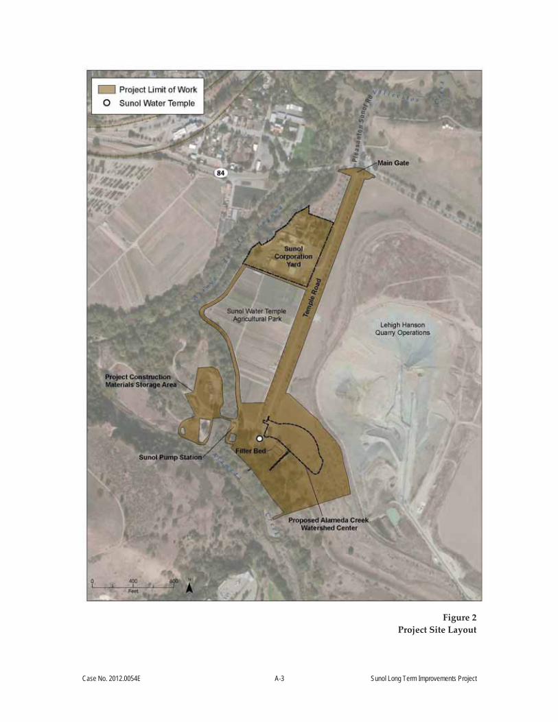
Sunol Yard would occur in the northern portion of the project site; construction of the proposed
Watershed Center would occur in an approximately 8-acre area in the southern portion of the
site, in the vicinity of the Sunol Water Temple (Figure 2).
1 SFPUC, 2001. Alameda Watershed Management Plan. April. 2 CCSF, 2000. Alameda Watershed Management Plan Final Environmental Impact Report. August.

Case No. 2012.0054E A-2 Sunol Long Term Improvements Project
Figure 1
Project Vicinity
Case No. 2012.0054E A-3 Sunol Long Term Improvements Project
Figure 2
Project Site Layout

Case No. 2012.0054E A-4 Sunol Long Term Improvements Project
The Sunol Yard provides a central location for the SFPUC’s maintenance and support operations
in the East Bay Area. Yard facilities include an administration building, offices, storage sheds,
several service and repair shops, covered and open-air storage areas, a potable water pump
station, a vehicle fueling island and fuel storage tanks, a staff residence, and miscellaneous
supporting structures. Because many of the existing facilities in the Sunol Yard are outdated and
have been determined by the SFPUC to be no longer serviceable, the project proposes the
upgrading or replacement of certain structures and facilities, along with a revised facilities layout
to improve efficiency in operations.
A second element of the project proposes the construction of a Watershed Center that would
house informational displays on the San Francisco water system, the history of the Sunol Valley,
and the ecological features of the Alameda Creek watershed. Access to the Watershed Center
would be offered to the general public and educational institutions. As part of the facility, the
project would create approximately 2 acres of native vegetation surrounding the Watershed
Center building. The area of native vegetation would include a “Watershed Discovery Trail”—a
meandering walk through a landscape reflecting the middle and upper reaches of the Alameda
Creek Watershed. Other parts of the project involve reopening a public picnic area, providing
pedestrian access to Alameda Creek, and performing landscape improvements around the Sunol
Water Temple.
A.3 Project Purpose
The project has two elements, and the purpose of each element is as follows: 1) to improve the
existing Sunol Yard by replacing outdated and no longer serviceable facilities with new
structures in an updated facility layout, to efficiently provide operations and maintenance
support to SFPUC operations in the East Bay area; and 2) to enhance the use and educational
value of the Sunol Water Temple site through the establishment of an interpretive facility, which
will provide information and activities that allow visitors to learn about and further appreciate
the Alameda Creek Watershed, including its natural resources, history, and role in the SFPUC
water system.
The Sunol Yard element of the project has the following objectives:
Improve workplace efficiency, safety, and security by replacing outdated facilities that no
longer meet SFPUC operational requirements with modern maintenance shops and
buildings that satisfy current building codes, including the California Building Standards

Case No. 2012.0054E A-5 Sunol Long Term Improvements Project
Code (2013), SFPUC seismic reliability standards,3 and the requirements of the
Occupational Safety and Health Administration and the Americans with Disabilities Act
(ADA).
Reduce environmental effects and enhance energy efficiency by designing and
constructing buildings that conform to California Title 24 energy usage standards, and
secure Leadership in Energy and Environmental Design (LEED) Gold certification for a
replacement administration building, consistent with San Francisco green building
requirements for municipal construction projects.
Revise the layout of the Sunol Corporation Yard to be more useable and efficient.
Repair the historic main gate, replace existing signage, and install shoulders along and
repave Temple Road.
The Watershed Center element of the project has the following objectives:
Develop indoor facilities and surrounding native vegetation communities that
communicate information regarding the natural resources of the Alameda Creek
Watershed and the role of the watershed in the SFPUC water system, as well as
providing water-wise and water-inspired learning opportunities.
Coordinate the interpretive center and new landscape elements with the historic Sunol
Water Temple, and provide information on the history of the watershed, Sunol Valley,
and SFPUC operations.
Integrate the interpretive facility with the educational activities of the existing Sunol
Water Temple Agricultural Park.
Provide public use opportunities at the new interpretive center, along with additional
recreational opportunities at a restored picnic area, including limited pedestrian access to
Alameda Creek.
Secure LEED Gold certification for the Watershed Center, in accordance with San
Francisco green building requirements for municipal construction projects, and ensure
that project design and construction is consistent with the California Building Standards
Code (2013), SFPUC seismic reliability standards, and ADA requirements.
3 SFPUC, 2014. General Seismic Requirements for Design of New Facilities and Upgrade of Existing Facilities. Revision 3, DOC No. WSIP/CSP-001-R2R3. June.

Case No. 2012.0054E A-6 Sunol Long Term Improvements Project
A.4 Project Components
The following subsections describe the proposed project elements. Construction of project
elements is subject to completion of environmental review, project approval, and acquisition of
permits, as well as the availability of final funding.
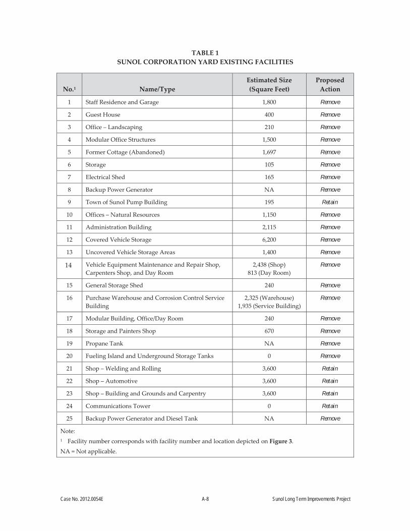
A.4.1 Sunol Corporation Yard Improvements
Due to loss of functionality and poor quality of construction, the buildings in the Sunol Yard
would be demolished and replaced by new structures, with the exception of three existing pre-
fabricated maintenance shops, the communications tower, and the Town of Sunol Pump Building
(depicted on Figure 3 and indicated in Table 1, below).
Proposed facilities at the Sunol Yard include four new shops (electrical and plumbing shop,
electronic maintenance technicians and radio shop, natural resources shop, and paint and blast
shop, including updated information technology and electrical systems); a replacement
administration building; a vehicle wash down area; and several covered storage structures. A
replacement backup power generator and diesel fuel storage tank would be installed. A
replacement outdoor lunch area for staff would also be provided. Two replacement underground
wastewater holding tanks would be installed, and existing underground fuel tanks would be
replaced with new aboveground fuel tanks at the relocated fueling station. Improvements would
include low-flow technology and fixtures to conserve water. A new natural gas filling and
possibly an electric vehicle charging station would be provided.
The Sunol Yard would be reconfigured to improve efficiency of operations, and buildings would
be arranged on a new street layout with areas for parking and landscaping. As a replacement for
the current open-air storage of maintenance vehicles and equipment, covered parking and
storage for SFPUC equipment would be constructed. Visitor parking would be provided on the
northern side of the Sunol Yard. Linear landscape corridors are included in the site plan to
provide shade and facilitate rainwater infiltration. Additionally, storm drainage collection and
treatment features would be installed, consisting of infiltration trenches, catch basins, and swales.
Existing security fencing and gates that surround the Sunol Yard will be updated for improved
access control and security.

Case No. 2012.0054E A-7 Sunol Long Term Improvements Project
Note: Facility number corresponds with facility number and type listed in Table 1.
Figure 3 Sunol Corporation Yard Existing Site Plan
Case No. 2012.0054E A-8 Sunol Long Term Improvements Project
TABLE 1 SUNOL CORPORATION YARD EXISTING FACILITIES
No.1 Name/Type Estimated Size (Square Feet)
Proposed Action
1 Staff Residence and Garage 1,800 Remove
2 Guest House 400 Remove
3 Office – Landscaping 210 Remove
4 Modular Office Structures 1,500 Remove
5 Former Cottage (Abandoned) 1,697 Remove
6 Storage 105 Remove
7 Electrical Shed 165 Remove
8 Backup Power Generator NA Remove
9 Town of Sunol Pump Building 195 Retain
10 Offices – Natural Resources 1,150 Remove
11 Administration Building 2,115 Remove
12 Covered Vehicle Storage 6,200 Remove
13 Uncovered Vehicle Storage Areas 1,400 Remove
14 Vehicle Equipment Maintenance and Repair Shop, Carpenters Shop, and Day Room
2,438 (Shop) 813 (Day Room)
Remove
15 General Storage Shed 240 Remove
16 Purchase Warehouse and Corrosion Control Service Building
2,325 (Warehouse) 1,935 (Service Building)
Remove
17 Modular Building, Office/Day Room 240 Remove
18 Storage and Painters Shop 670 Remove
19 Propane Tank NA Remove
20 Fueling Island and Underground Storage Tanks 0 Remove
21 Shop – Welding and Rolling 3,600 Retain
22 Shop – Automotive 3,600 Retain
23 Shop – Building and Grounds and Carpentry 3,600 Retain
24 Communications Tower 0 Retain
25 Backup Power Generator and Diesel Tank NA Remove
Note: 1 Facility number corresponds with facility number and location depicted on Figure 3.
NA = Not applicable.

Case No. 2012.0054E A-9 Sunol Long Term Improvements Project
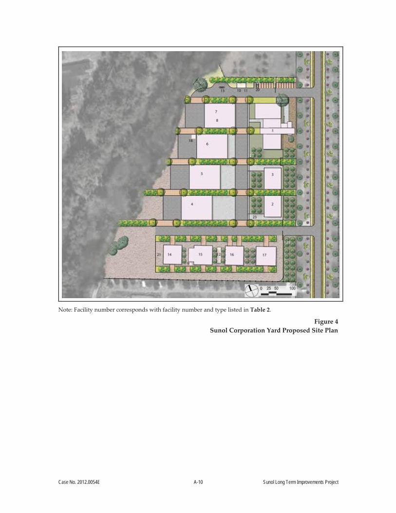
The proposed reconfiguration of the Sunol Yard is depicted on Figure 4 and outlined in Table 2.
This project element would also include repair work on the historic main gate and the installation
of shoulders composed of resin pavement or like material along Temple Road; the shoulders
would also function as a pedestrian walkway. The main gate is composed of columns with semi-
circular walls that frame the access to the Sunol Water Temple. Features including the existing
concrete pillars would be inspected and repaired consistent with the original design. The existing
wrought-iron fence and gate would be cleaned and repainted, or where necessary, components of
the fence would be replaced. The existing modern gate opener and hardware would be upgraded
to meet current security standards. Temple Road would be repaved as funding allows.
A.4.2 Development of Alameda Creek Watershed Center
The project proposes to construct a Watershed Center (approximately 13,000 square feet) in the
vicinity of the Sunol Water Temple (Figure 5). A one-story structure would include an
interpretive display area, history alcoves, watershed discovery lab, community room, restrooms,
entry plaza, reception area, and administrative offices. The proposed Watershed Center site
would also include a covered patio and outdoor amphitheater. A new underground wastewater
holding tank would be installed near the Watershed Center. Low-flow technology and fixtures
would be incorporated into the design to conserve water. Existing fencing would be relocated to
the northern edge of the project site; additional low-height perimeter fencing would be installed
at the Watershed Center where needed for the safe use of the area by visitors, including for the
exclusion of visitors from the lower areas of the filter galleries. As part of the integration of
Watershed Center with the educational activities of the existing Sunol Water Temple Agricultural
Park, a walking path, including pedestrian safety features such as striping, would link the two
locations.
The existing (but not currently in use) picnic area south of the Sunol Water Temple would be
improved and re-opened to the public. Improvements would include an ADA-compliant access
path and stairs, new picnic tables, and a play structure for children. These facilities would be
subject to ongoing monitoring and maintenance. The existing abandoned restroom facilities in
the picnic area would be removed, and public restrooms would be available in the Watershed
Center. The existing barbed-wire-topped fencing at the picnic area would be replaced with a low-
height perimeter fence consistent with recreational uses. The fence would include a gate,
providing limited pedestrian access adjacent to Alameda Creek.
Case No. 2012.0054E A-10 Sunol Long Term Improvements Project
Note: Facility number corresponds with facility number and type listed in Table 2.
Figure 4 Sunol Corporation Yard Proposed Site Plan

Case No. 2012.0054E A-11 Sunol Long Term Improvements Project
TABLE 2 SUNOL CORPORATION YARD PROPOSED AND RETAINED FACILITIES
No.1 Name/Type Estimated Size2
(Square Feet)
1 Administration Building 11,500
2 Shop – Plumbing and Electrical 3,600
3 Shop – Electronic Maintenance Technicians and Radio 3,600
4 Covered Material Storage 8,000
5 Large Equipment Covered Storage #1 8,000
6 Large Equipment Covered Storage #2 8,000
7 and 8 Covered Storage and Natural Resources Shop 8,000
9 Transformer Pad NA
10 Aboveground Bio-Diesel and Gasoline Storage Tanks NA
11 Shade Canopy/Enclosure for Fuel Tanks NA
12 Backup Power Generator and Aboveground Diesel Storage Tank NA
13 Fuel Station NA
14 (Retained) Shop – Welding and Rolling 3,700
15 Shop – Paint and Blast 4,500
16 (Retained) Shop – Automotive 3,700
17 (Retained) Shop – Building and Grounds and Carpentry 4,100
18 (Retained) Town of Sunol Pump Building 200
19 Natural Gas Storage Tank NA
20 Natural Gas Fueling Appliance NA
21 Wash Rack Area NA
22 (Retained) Communications Tower NA
23 Underground Wastewater Holding Tanks NA
Notes: 1 Facility number corresponds with facility number and location depicted on Figure 4. 2 All proposed buildings will be one story.
NA = Not applicable.

Case No. 2012.0054E A-12 Sunol Long Term Improvements Project
Figure 5
Alameda Creek Watershed Center Proposed Site Plan
To enhance the viewshed at the Sunol Water Temple and along Temple Road, the paved area
directly in front of the temple would be replaced with a landscaped forecourt that includes a
visitor drop-off area, and an inoperable wheelchair lift on the temple would be removed and
replaced with a functioning, ADA-compliant wheelchair lift on the south side of the temple. An
existing dirt parking area (approximately 15 parking spaces) and an abandoned concrete pad
would also be removed from the foreground to the Temple; a replacement parking area would be
located south of the Watershed Center (approximately 30 parking spaces and three bus spaces),
along with a small short term parking area along the Watershed Center access road
(approximately 5 parking spaces) and bicycle racks. Also, the existing pavement immediately
around the temple would be replaced and would match the circular shape of the temple.
Case No. 2012.0054E A-13 Sunol Long Term Improvements Project
As part of project planning activities, several locations in Sunol Valley were considered as
candidate sites for the proposed Watershed Center.4 The location at the Sunol Water Temple was
determined by the SFPUC to be the only site capable of feasibly achieving all project objectives
(see Section A.3, Project Purpose) and presented the least potential for project impacts as
compared to other potential areas onsite. The proposed location was identified as having a
reduced flood risk and would allow compliance with the requirements of the San Francisco
Floodplain Management Ordinance (see Section E.15, Hydrology and Water Quality, and Figure
15, FEMA Flood Hazard Area Map); would minimize the need for imported fill (see Section E.15,
Hydrology and Water Quality); would minimize impacts to agricultural lands (see Section E.18,
Agriculture and Forest Recourses); would allow for a design that avoids impacts to a viewshed
in an eligible historic district (see Section E.4, Cultural and Paleontological Resources); and
would provide a safe traffic and pedestrian environment for users of the Watershed Center,
including children (see Section E.5, Transportation and Circulation).
A.4.3 Lighting
Lighting systems and controls would be designed to meet the State of California Title 24 Energy
Efficiency requirements, and illumination levels would be consistent with recommendations of
the Illumination Engineering Society Lighting Handbook. Lighting for outdoor facilities would
be designed to minimize glare and light pollution in adjacent areas and would include building-
and pole-mounted cutoff luminaires. Outdoor lighting in landscaped areas and areas visible to
the public would be coordinated with the project’s architects. Selection of lighting fixtures would
occur during final design. Emergency illumination and egress lighting would be provided in all
appropriate spaces, as required by the California Building Standards Code.
A.4.4 Ancillary Components
Additional components include extension of utilities such as water, natural gas, and
communications from the Sunol Yard to the new Watershed Center. The conduits would be
buried in shallow trenches at depths of no more than 6 feet below ground surface (bgs) along the
eastern side of Temple Road. An electrical transmission line would be extended underground
from the existing power pole adjacent to the Sunol Pump Station to the Watershed Center. As
4 SFPUC, 2015. Site Screening Analysis Memorandum. January
Case No. 2012.0054E A-14 Sunol Long Term Improvements Project
discussed above, replacement fencing and/or extensions to existing fencing surrounding the new
facilities are also proposed at project locations, as necessary.
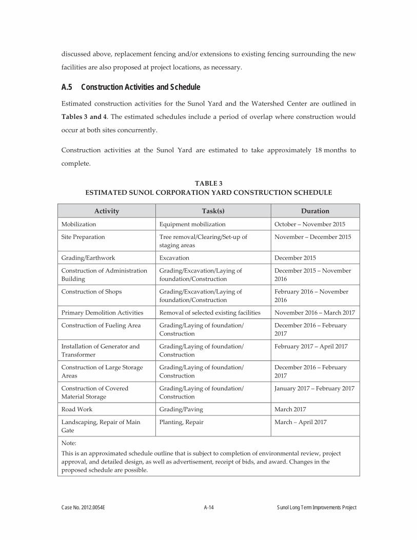
A.5 Construction Activities and Schedule
Estimated construction activities for the Sunol Yard and the Watershed Center are outlined in
Tables 3 and 4. The estimated schedules include a period of overlap where construction would
occur at both sites concurrently.
Construction activities at the Sunol Yard are estimated to take approximately 18 months to
complete.
TABLE 3 ESTIMATED SUNOL CORPORATION YARD CONSTRUCTION SCHEDULE
Activity Task(s) Duration
Mobilization Equipment mobilization October – November 2015
Site Preparation Tree removal/Clearing/Set-up of staging areas
November – December 2015
Grading/Earthwork Excavation December 2015
Construction of Administration Building
Grading/Excavation/Laying of foundation/Construction
December 2015 – November 2016
Construction of Shops Grading/Excavation/Laying of foundation/Construction
February 2016 – November 2016
Primary Demolition Activities Removal of selected existing facilities November 2016 – March 2017
Construction of Fueling Area Grading/Laying of foundation/Construction
December 2016 – February 2017
Installation of Generator and Transformer
Grading/Laying of foundation/Construction
February 2017 – April 2017
Construction of Large Storage Areas
Grading/Laying of foundation/Construction
December 2016 – February 2017
Construction of Covered Material Storage
Grading/Laying of foundation/Construction
January 2017 – February 2017
Road Work Grading/Paving March 2017
Landscaping, Repair of Main Gate
Planting, Repair March – April 2017
Note:
This is an approximated schedule outline that is subject to completion of environmental review, project approval, and detailed design, as well as advertisement, receipt of bids, and award. Changes in the proposed schedule are possible.
Case No. 2012.0054E A-15 Sunol Long Term Improvements Project
Construction activities for the Watershed Center are estimated to take approximately 18 months
to complete.
TABLE 4 ESTIMATED ALAMEDA CREEK WATERSHED CENTER CONSTRUCTION SCHEDULE
Activity Task(s) Duration
Mobilization Construction equipment mobilization March – April 2016
Site Preparation Clearing/Set-up of staging areas April – May 2016
Grading/Earthwork Excavation May – June 2016
Construction of Watershed Center Structure
Grading/Excavation/Laying of foundation/Construction
June 2016 – June 2017
Interpretive Display Installation Installation of exhibits June – September 2017
Updating Picnic Area Grading/Installation of ramp and equipment
June – July 2017
Road Work Grading/Paving June 2017
Landscaping Planting June – September 2017
Note:
This is an approximated schedule outline that is subject to completion of environmental review, project approval, and detailed design, as well as advertisement, receipt of bids, and award. Changes in the proposed schedule are possible.
A.5.1 Facilities
Facilities construction would generally involve three types of construction activities: site
preparation, excavation, and building construction.
Site Preparation
Site preparation would involve demolition and removal of existing structures, tree removal,
clearing, minor leveling, and grading where necessary. Removal of existing structures at the
Sunol Yard would produce an estimated 2,000 cubic yards of demolished building materials.
Materials would be disposed of or recycled, consistent with applicable regulations, at appropriate
facilities accessed via I-680. Any hazardous materials, including asbestos, encountered during
demolition would be contained, transported, and disposed of in accordance with applicable laws
and regulations.

Case No. 2012.0054E A-16 Sunol Long Term Improvements Project
Excavation
Excavation of the building foundations would be accomplished by backhoe or excavator. The
depth of the excavations would vary depending on facility height and site conditions, but would
generally not exceed 5 feet below the current ground surface, except at the locations of the
existing underground fuel storage tanks and existing and proposed wastewater holding tanks,
where excavation work may range to 15 feet below grade. Estimated cut and fill quantities for the
Sunol Yard and the Watershed Center are provided in Tables 5 and 6, respectively. Shallow
trenches necessary for utility conduits would be excavated by backhoe or trencher.
TABLE 5 SUNOL CORPORATION YARD ESTIMATED CUT AND FILL QUANTITIES
Item Volume (cubic yards)
Imported material 7,000
Excavated material 20,000
Excavated material to be reused at Sunol Yard 6,000
Surplus excavated materials 14,000
Portion for offsite disposal 4,000
Excavated material to be reused at Watershed Center 10,000
TABLE 6 ALAMEDA CREEK WATERSHED CENTER ESTIMATED CUT AND FILL QUANTITIES
Item Volume (cubic yards)
Excavated material (reused onsite) 500
Imported material (i.e., reused) from Sunol Yard 10,000
Building Construction
Generally, buildings would use steel structural framing atop reinforced concrete foundations. All
buildings would be designed in accordance with the California Building Standards Code (2013)
and the SFPUC seismic reliability standards.5 The proposed Administration Building at the Sunol
5 SFPUC, 2014. General Seismic Requirements for Design of New Facilities and Upgrade of Existing Facilities. Revision 3, DOC No. WSIP/CSP 001 R2R3. June.
Case No. 2012.0054E A-17 Sunol Long Term Improvements Project
Yard and the Watershed Center would be designed to achieve LEED Gold Certification
addressing sustainable sites, water efficiency, energy and atmosphere, materials and resources,
and indoor environmental quality. Therefore, the stormwater systems for both the Sunol Yard
Administration Building and the Watershed Center would be designed to achieve the LEED
SS6.2 credit. The SFPUC also intends to construct all proposed buildings at the Sunol Yard
outside of the Federal Emergency Management Agency (FEMA)-estimated floodway associated
with inundation caused by the 1-Percent Annual Chance Flood (also referred to as the 100-year
flood event) and above the floodplain associated with the 1-Percent Annual Chance Flood. The
Watershed Center is proposed to be located outside of the FEMA-estimated floodway and above
the floodplain subject to inundation by the 1-Percent Annual Chance Flood.
A.5.2 Fencing
Replacement, maintenance, and installation of fencing will be completed at the Sunol Yard, the
Watershed Center and associated picnic area, filter galleries, and Temple Road, in addition to the
relocation of an existing fence to the edge of the proposed Watershed Center site.
A.5.3 Landscaping
Landscaping would be an essential component of this project. Landscaping proposed for the
Sunol Yard would include mostly native and/or climate-appropriate planting materials with
massing of deciduous trees to create shade cover and reduce heat island effect. At the Watershed
Center, a forecourt of drought tolerant lawn or landscaping would serve as a formal point of
arrival as well as a recreational space. As with the Sunol Yard, drought-resistant native plantings
and shade areas are planned for the Watershed Center. As discussed above, a Watershed
Discovery Trail is proposed as part of the Watershed Center. Energy and water conservation
practices would be incorporated into landscape design.
A.5.4 Construction Staging Areas
Staging would occur at each project site, with a supplementary staging area in the southwestern
quadrant of the project location, in an area that is currently used as a materials storage area.
Staging areas would be used by contractors for storage of construction-related equipment and
materials, such as construction trailers and vehicles, materials, and small quantities of fuels and
lubricants. The construction staging areas, which may require minor leveling, could also be used
for the stockpiling of excavated soil for reuse. Once a staging area is no longer needed, it would
be restored to its previous condition.

Case No. 2012.0054E A-18 Sunol Long Term Improvements Project
A.5.5 Construction Equipment
Project construction would include grading, excavations, and erection of building structures
within the project limit of work area (see Figure 2). Construction equipment would include
standard dump trucks, flatbed trucks, watering trucks, concrete mixers, bulldozers, backhoes,
excavators, front-end loaders, compactor/rollers, sawcutting machines, forklifts, cranes, a Baker-
type water storage tank and dewatering systems, and other equipment as needed. Most types of
equipment would only be needed for certain phases of the construction activities. A temporary
150-kilowatt generator would be used for intermittent peak demands during construction. If
needed, portable lighting would be used; lights would be pointed down at the construction site
(away from nearby properties).
A.5.6 Construction and Public Access
Public roadways or unpaved service roads on SFPUC land would provide the primary access
routes to the project sites. Project construction workers would park in a number of permanent
and temporary onsite parking areas at the project site, or in construction staging areas. There
would be no worker parking along public ROWs. The Sunol Yard would remain in operation
during construction.
To ensure public and traffic safety during construction, access to the existing agricultural park for
tours and events would require advance coordination with the SFPUC, and would involve
periodic interruptions in access; no public access would be provided to the Sunol Water Temple
while project construction activities are ongoing at the Sunol Yard or the Watershed Center.
A.5.7 Construction Workforce and Construction Hours
The number of construction workers on site would vary based on construction activity. Tables 7
and 8 estimate the number of construction workers by activity at the Sunol Yard and the
Watershed Center, respectively.

Case No. 2012.0054E A-19 Sunol Long Term Improvements Project
TABLE 7 SUNOL CORPORATION YARD ESTIMATED NUMBER OF CONSTRUCTION WORKERS
Construction Activity Average per Day Maximum
Administration building 12 18
Shops 10 15
Demolition of existing facilities 8 14
Construction of fuel tank site 5 8
Installation of generator and transformer 5 8
Storage areas 7 10
Landscaping/Paving 5 8
TABLE 8 ALAMEDA CREEK WATERSHED CENTER ESTIMATED NUMBER OF CONSTRUCTION
WORKERS
Construction Activity Average per Day Maximum
Building 10 14
Landscaping/Paving/Displays 10 14
Because construction would overlap at the Sunol Yard and Watershed Center, it is likely that
construction crews would be working at the sites simultaneously. Construction activities are
expected to occur Monday through Friday, from 7:00 a.m. to 7:00 p.m.; and on weekends from
8:00 a.m. to 5:00 p.m. Portable temporary lighting may be used during the course of construction
and would be directed downward to minimize light trespass to adjacent areas.
A.5.8 Standard Construction Measures
The SFPUC has established Standard Construction Measures to be included in all construction
contracts.6 The main objective of these measures is to avoid and reduce impacts on existing
resources to the extent feasible. A goal of the proposed project is to integrate best management
practices (BMPs) throughout project development, to provide source control and water quality
6 SFPUC, 2007. Standard Measures to be Included in Construction Contracts and Project Implementation. February 7.
Case No. 2012.0054E A-20 Sunol Long Term Improvements Project
treatment of runoff from paved and other developed areas prior to discharge into the swales and
infiltration trenches that percolate flows to groundwater and discharge into Alameda Creek and
Arroyo de la Laguna. Among other measures, the SFPUC would require that the contractor
provide notification at least 14 days in advance to businesses, property owners, facility managers,
and residents of adjacent areas potentially affected by project construction, regarding the nature,
extent, and duration of construction activities. The measures also call for the contractor to
implement avoidance measures where necessary to protect special status biological resources, if
present. In addition, the contractor would prepare a Traffic Control Plan to minimize traffic
impacts on streets affected by construction of the project.
The Standard Construction Measures stipulate that all construction contractors must implement
construction stormwater BMPs. At a minimum, construction contractors would be required to
undertake the following measures, as applicable, to minimize adverse effects of construction
activities on water quality: erosion and sedimentation controls tailored to the site and project;
preservation of existing vegetation; installation of silt fences, use of wind erosion control (e.g.,
geotextile or plastic covers on stockpiled soil); and stabilization of site ingress/egress locations to
minimize erosion. Furthermore, if groundwater is encountered during any excavation activities,
the contractor shall ensure that water is discharged in compliance with all applicable standards
and requirements.
A.6 Operations and Maintenance
The SFPUC is responsible for the storage, quality control, and distribution of the area's drinking
water. The water supply system stretches from the Sierra Nevada to the City of San Francisco,
and features a complex series of reservoirs, tunnels, pipelines, and treatment systems. The Sunol
Valley occurs near the midpoint of this system, which delivers millions of gallons of fresh water
to customers in Santa Clara, Alameda, San Francisco, and San Mateo Peninsula communities. The
Sunol Valley location is of major importance as the Sunol Yard functions as the operational
headquarters for SFPUC East Bay operations.
Sunol Yard activities center on the operations and maintenance of water supply lines. Carpentry,
plumbing, welding, painting and electrical work, engineering, and automotive repair are regular
activities conducted in yard shop facilities. Sunol Yard also houses various materials and
equipment used to maintain the water system in the Sunol region. The majority of Sunol Yard
staff work in the field full time. These employees pick up vehicles, equipment, and materials at
Case No. 2012.0054E A-21 Sunol Long Term Improvements Project
the Sunol Yard, and then depart to work off site. Sunol Yard administrative staff is office-based,
and manages and supports the overall function of various SFPUC departments based in Sunol.
There would be little change in the operation and maintenance of improved project facilities at
the Sunol Yard. No additional staffing would be needed to operate and maintain the proposed
facilities, although additional office staff are planned to use Sunol Yard following project
completion. Presently, approximately 47 staff use the Sunol Yard, an estimated 31 of whom work
full time in the field. Approximately 61 staff are planned to use the yard following completion.
The Watershed Center would be staffed with four employees. The site would be open to the general
public Monday through Friday, approximately from 9:00 a.m. to 3:00 p.m., and it is proposed to be
open on the weekends and for periodic evening events; however, access to the Watershed Center
and associated picnic area would depend on future budget considerations. Access to the Watershed
Center would be available for educational uses and special events.
All buildings would require daily and weekly maintenance activities and general upkeep.
Landscaping would also need to be maintained.
A.7 Required Actions and Approvals
This Initial Study (IS)/Mitigated Negative Declaration (MND) is intended to provide the
environmental analysis necessary for the planning, development, approval, construction,
operations, and maintenance of the project. In addition to this IS/MND, the proposed project is
likely to require the following state and local agency actions and permits:
State Water Resources Control Board (SWRCB): National Pollutant Discharge
Elimination System (NPDES) Order 2009-0009-DWQ, “General Permit for Storm Water
Discharges Associated with Construction and Land Disturbance Activities”
(Construction General Permit).
Encroachment permit from the California Department of Transportation (Caltrans) (if
needed to accommodate repair work on the main gate, which is adjacent to SR 84).
Compliance with Alameda County Environmental Health Underground Storage Tank
Program and Above Ground Storage Tanks protocol for hazardous materials.
To locate the proposed Watershed Center on SFPUC land between the existing quarry and Sunol
Water Temple, the SFPUC would also need to modify its existing lease agreement with Mission
Valley Rock Company to return to the SFPUC the use of a portion of the lease area that is not

Case No. 2012.0054E A-22 Sunol Long Term Improvements Project
slated for future quarrying. The proposed project would not likely require permits from the
U.S. Army Corps of Engineers or the RWQCB under Sections 404 or 401 of the federal Clean
Water Act, because the project would not require the placement of material within jurisdictional
waters of the United States. Furthermore, no impacts on federally or state-listed species or habitat
are anticipated (see Section E.13, Biological Resources, below). Therefore, the project is not likely
to require take authorization from the U.S. Fish and Wildlife Service (USFWS), National Marine
Fisheries Service, or the California Department of Fish and Wildlife (CDFW).
Case No. 2012.0054E B-1 Sunol Long Term Improvements Project
B. PROJECT SETTING
B.1 Regional and Local Setting
The project site is in the Sunol Valley in unincorporated Alameda County, west of I-680 and
south of SR 84, on Alameda watershed lands owned by the City and County of San Francisco
(CCSF) and managed by the SFPUC. The Alameda watershed is largely undeveloped, and
consists primarily of rolling grassland and scattered oak woodlands. Existing SFPUC facilities in
the Sunol Valley include water supply storage facilities (Calaveras and San Antonio Reservoirs);
numerous transmission facilities (including the Alameda Siphons, Coast Range and Irvington
Tunnels, Calaveras Pipeline, San Antonio Pipeline, and San Antonio Pump Station); and water
treatment facilities (Sunol Valley Water Treatment Plant [SVWTP], Sunol Valley Chloramination
Facility, and a fluoride facility).
B.2 Other Projects in the Vicinity
Past, present, and reasonably foreseeable future projects occurring in the vicinity of proposed
project site could result in cumulative impacts in combination with the SLTI project impacts.
These projects are as follows:
Several projects involving the SFPUC (Alameda Creek Recapture Project, Alameda
Siphons Seismic Reliability Upgrade, New Irvington Tunnel, SVWTP Expansion and
Treated Water Reservoir, San Antonio Pump Station Upgrade, Various Pipeline
Inspection Projects, San Antonio Reservoir Hypolimnetic Oxygenation System, Calaveras
Dam Replacement, Geary Road Bridge Replacement, San Antonio Backup Pipeline
Project, and the Town of Sunol Fire Suppression Project)
Several roadway and infrastructure improvement projects (SR 84 Safety Project, SR 84
Expressway Widening Project, I-680 High-Occupancy Vehicle Lane, Alameda Creek
Bridge Replacement Project, Pacific Gas and Electric Company Gas Pipeline Crossing,
Alameda County Fire Department Sunol Project)
Resource management plans and projects (Stream Management Master Plan
Improvements and Rubber Dam No. 1 and Bay Area Rapid Transit Weir Fish Passage
Project)
An active mining operation adjoining the project site (SMP-32 Quarry Operations)

Case No. 2012.0054E B-2 Sunol Long Term Improvements Project
Table 9 in Section E, Evaluation of Environmental Effects, describes the potential cumulative
projects in the project vicinity. The discussion of potential cumulative impacts is included in the
individual environmental issue area subsections in Section E.

Case No. 2012.0054E C-1 Sunol Long Term Improvements Project
C. COMPATIBILITY WITH EXISTING ZONING AND PLANS
Applicable Not Applicable
Discuss any variances, special authorizations, or changes proposed to the Planning Code or Zoning Map, if applicable.
Discuss any conflicts with any adopted plans and goals of the City or Region, if applicable.
Discuss any approvals and/or permits from City departments other than the Planning Department or the Department of Building Inspection, or from Regional, State, or Federal Agencies.
No variances, special authorizations, or changes to the San Francisco Planning Code or Zoning
Map are proposed as part of this project; therefore, these issues are not applicable and are not
discussed further.
This section provides a general description of the land use plans and policies, and how they
apply to the project; and discusses potential inconsistencies between this project and the
applicable plans. Approvals and permits required for project implementation are provided in
Section A.7, Required Actions and Approvals. The focus of this section is on CCSF land use
plans and policies, the SFPUC’s plans and policies, and other regional and local plans that apply
to the project. The project site is in Alameda County, on property that is owned and managed by
the SFPUC. The SFPUC is an agency of CCSF, and therefore is under the jurisdiction of the City’s
charter and plans, where applicable. In addition, the SFPUC has adopted plans specific to the
management of the agency’s water resources. The SFPUC is not legally bound by the land use
plans and policies of other jurisdictions; however, non-CCSF land use plans are discussed to the
extent that they provide general land use planning information for the jurisdiction in which the
project is located. This information is also relevant to the evaluation of project impacts with
respect to compatibility of a project with certain aspects of local land use plans and policies.
C.1 City and County of San Francisco Plans and Policies
The CCSF land use plans and policies are primarily applicable to projects within the jurisdictional
boundaries of the City of San Francisco, although in some cases they may apply to projects
outside these boundaries. CCSF has authority (San Francisco Charter, Section 4.112) over the
management, use, and control of land it owns outside of the city, subject to the SFPUC’s exclusive
charge of the construction, management, use, and control of city water supplies and utilities (San

Case No. 2012.0054E C-2 Sunol Long Term Improvements Project
Francisco Charter, Section 8B.121). Accordingly, CCSF considers its own plans and policies on its
extraterritorial lands, as applicable.
California Government Code Section 53090 et seq. provides that the SFPUC receive
intergovernmental immunity from the zoning and building laws of other cities and counties. The
SFPUC, however, seeks to work cooperatively with local jurisdictions where CCSF-owned
facilities are sited outside of San Francisco, to avoid conflicts with local land use plans and
building and zoning codes. Also, the SFPUC is required under Government Code
Section 65402(b) to inform local governments of its plans to construct projects or acquire or
dispose of its extraterritorial property. Local governments have a 40-day review period to
determine project consistency with their general plans. Under this requirement, the cities’ or
counties’ determinations of consistency are advisory to the SFPUC, rather than binding.
C.1.1 San Francisco General Plan
The San Francisco General Plan,7 as amended, sets forth the comprehensive long-term land use
and development policies for San Francisco. One of the basic goals of the San Francisco General
Plan is “coordination of the growth and development of the city with the growth and
development of adjoining cities and counties and of the San Francisco Bay Region.” The San
Francisco General Plan consists of ten issue-oriented plan elements: Air Quality; Arts; Commerce
and Industry; Community Facilities; Community Safety; Environmental Protection; Housing;
Recreation and Open Space; Transportation; and Urban Design. The elements that may be
relevant to the project are briefly described below.
Air Quality Element. This element promotes the goal of clean air planning through
objectives and policies aimed at adhering to air quality regulations.
Community Safety Element. This element addresses the potential for geologic,
structural, and nonstructural hazards to affect city-owned structures and critical
infrastructure. The goal of this element is to protect human life and property from
hazards.
Environmental Protection Element. This element addresses the impact of urbanization
on the natural environment. The element promotes the protection of plant and animal life
and freshwater sources, and speaks to San Francisco’s responsibility to provide a
7 CCSF, 1988. San Francisco General Plan. As amended through 1996.
Case No. 2012.0054E C-3 Sunol Long Term Improvements Project
permanent, clean water supply to meet present and future needs and to maintain an
adequate water distribution system.
Recreation and Open Space Element. This element is composed of several sections, each
dealing with a certain aspect of the City's recreation and open space system, including
the Regional Open Space System, the Citywide Open Space System, the Shoreline, the
Neighborhoods, and Downtown.
Urban Design Element. This element promotes the preservation of landmarks and
structures with notable historic, architectural, or aesthetic value, and seeks to balance
development with its natural environmental and visual features.
The San Francisco General Plan sets forth CCSF’s comprehensive long-term land use policy, and
as such, is primarily applicable to projects within CCSF’s jurisdictional boundaries. The project,
which lies outside CCSF boundaries, consists of upgrading the existing Sunol Yard and picnic
area, and constructing a new Watershed Center. The project would result in long-term
improvement of the reliability of the water and power systems to meet customer needs; therefore,
the project would support the health and safety of the communities that are served by the SFPUC
utility systems. In addition, the project would adhere to air quality regulations and preserve the
integrity of existing historic structures. Therefore, the project would not conflict with the San
Francisco General Plan and its goals.
C.1.2 Accountable Planning Initiative
In November 1986, the voters of San Francisco approved Proposition M, the Accountable
Planning Initiative, which added Section 101.1 to the City Planning Code to establish eight
priority planning policies to the San Francisco General Plan. The Priority Policies serve as the
basis upon which inconsistencies in the San Francisco General Plan are to be resolved. The eight
Priority Policies state that:
1. Neighborhood-serving retail uses be preserved and enhanced, and future opportunities
for resident employment in and ownership of such businesses be enhanced.
2. Housing and neighborhood character be conserved and protected to preserve the cultural
and economic diversity of the neighborhoods.
3. The City’s supply of affordable housing be preserved and enhanced.
4. Commuter traffic not impede the Muni transit service or overburden streets or
neighborhood parking.

Case No. 2012.0054E C-4 Sunol Long Term Improvements Project
5. Diverse economic base be maintained by protecting industrial and service sectors from
displacement by commercial office development, and future opportunities for resident
employment and ownership in these sectors be enhanced.
6. The City achieve the greatest possible preparedness to protect against injury and loss of
life in an earthquake.
7. Landmarks and historic buildings be preserved.
8. Parks and open space and their access to sunlight and vistas be protected from
development.
Of the eight priority policies, only the sixth, seventh, and eighth (relating to earthquakes, historic
buildings, and parks and open space, respectively) would be relevant to the project. The
remaining five policies would not be relevant because the project would: 1) be constructed
outside of San Francisco; 2) be located away from San Francisco neighborhoods; 3) have no effect
on nor create the need for affordable housing; 4) not result in any increase in commuter
automobiles; and 5) not result in commercial office development. Priority policy 6 is aimed at
helping the City achieve the greatest possible preparation to protect against injury and loss of life
in the event of an earthquake. The project would help ensure the reliability of the City’s water
and power systems in the event of a major earthquake by improving the SFPUC’s ability to
maintain and repair its water and power system facilities rapidly and reliably, thus protecting
water and power availability during emergencies. With respect to priority policy 7, preservation
of landmarks and historic buildings, the project would not result in significant effects on
landmarks or historic buildings. Project construction activities could cause a substantial adverse
change in the significance of the Sunol Water Temple and main gate, an eligible historic resource.
This would be a significant impact. However, mitigation has been incorporated to reduce this
impact to a less-than-significant level (see Section E.4, Cultural and Paleontological Resources).
The Watershed Center location was chosen specifically to avoid any impacts to views of the
Sunol Water Temple from Temple Road. Neither the single-story Watershed Center nor the
Watershed Discovery Trail would result a change in access to sunlight to the surrounding open
space areas. Additionally, improvements to the existing picnic area would not result in the
addition of any structures or features that would result in a change to access to sunlight or vistas.
Therefore, the project would not conflict with the Accountable Planning Initiative.

Case No. 2012.0054E C-5 Sunol Long Term Improvements Project
C.1.3 San Francisco Sustainability Plan
Although the San Francisco Board of Supervisors endorsed the Sustainability Plan for the City of
San Francisco8 in 1997, the board has not committed CCSF to perform the actions addressed in
the plan. The plan serves as a blueprint for sustainability, with many of its individual proposals
requiring further development and public comment. The plan’s underlying goals are to maintain
the physical resources and systems that support life in San Francisco, and to create a social
structure that will allow such maintenance. It is divided into 15 topic areas. Ten of these areas
address specific environmental issues: air quality; biodiversity; energy; climate change and ozone
depletion; food and agriculture; hazardous materials; human health; parks, open spaces, and
streetscapes; solid waste; transportation; and water and wastewater. Five of these areas are
broader in scope and cover many issues, including the economy and economic development;
environmental justice; municipal expenditures; public information and education; and risk
management. Under the topic of “water” are goals addressing water reuse, water quality, water
supply, groundwater supply, and infrastructure. Each topic area has a set of indicators that is to
be used over time to determine whether San Francisco is moving in a direction that supports
sustainability for that area.
The Sustainability Plan for the City of San Francisco was developed to address the city’s long-
term environmental sustainability. The project would not conflict with the goals of the plan,
because it would not result in increased water demand or use and would maintain the physical
resources and systems that support life in San Francisco. Furthermore, the Administration
Building at the Sunol Yard and the Watershed Center would be certified as LEED Gold, which
addresses sustainable sites; water efficiency; energy and atmosphere; materials and resources;
and indoor environmental quality.
C.1.4 San Francisco Floodplain Management Ordinance
The 2008 San Francisco Floodplain Management Ordinance, approved by San Francisco’s mayor
and Board of Supervisors as Chapter 2A, Article XX, Sections 2A.280 through 2A.285 of the City’s
Administrative Code, requires that new or substantially improved buildings in FEMA-identified
special flood hazard areas be protected against flood damage, and restricts uses that would
increase flood risks. In general, the ordinance requires that the first floor of buildings in flood
8 CCSF, 1997. The Sustainability Plan for the City of San Francisco. Department of the Environment.

Case No. 2012.0054E C-6 Sunol Long Term Improvements Project
zones be constructed above the floodplain or be flood-proofed, and be consistent with applicable
federal and state floodplain management regulations. The ordinance applies to construction on
CCSF-owned properties outside the boundaries of San Francisco.9
The project does not propose the construction of buildings in the FEMA-identified floodway and
all proposed buildings will be above the floodplain subject to inundation by the 1-Percent Annual
Chance Flood. Therefore, the project would be consistent with the 2008 San Francisco Floodplain
Management Ordinance.
C.2 SFPUC Plans and Policies
C.2.1 SFPUC Strategic Sustainability Plan
The SFPUC’s 2011 Strategic Sustainability Plan provides a framework for planning, managing,
and evaluating SFPUC-wide performance that takes into account the long-term economic,
environmental, and social impacts of the SFPUC’s business activities. This plan consists of a
“Durable Section,” which contains goals, objectives, and performance indicators to implement
SFPUC’s vision and values. The goals and objectives are then used to drive the “Dynamic
Section” of the Sustainability Plan, which contains specific actions, targets, measures, and
budgeting. The SFPUC uses this document to evaluate its performance semiannually, to provide
an annual score card, and to help the SFPUC measure progress on an annual basis.10
The proposed project is a facility improvement project that would meet the SFPUC’s objective in
improving capital facilities.
C.2.2 Water Enterprise Environmental Stewardship Policy
Adopted in June 2006, the Water Enterprise Environmental Stewardship Policy established the
long-term management direction for CCSF-owned lands and natural resources affected by
operation of the SFPUC regional water system in the Tuolumne River, Alameda Creek, and
Peninsula watersheds.11 It also addresses right-of-way (ROW) and properties in urban
surroundings under SFPUC management. The Environmental Stewardship Policy is integrated
9 CCSF, 2010. San Francisco Floodplain Management Program Fact Sheet. CCSF Office of the City Administrator. Revised January 29.
10 SFPUC, 2011. Strategic Sustainability Plan. March. 11 SFPUC, 2006. SFPUC Final Water Enterprise Environmental Stewardship Policy. June 27.

Case No. 2012.0054E C-7 Sunol Long Term Improvements Project
into Water Enterprise planning and decision-making processes, and also directly implemented
through a number of efforts, including the Alameda WMP.
The project site is in the Alameda Creek watershed, and would be subject to Water Enterprise
Environmental Stewardship Policy provisions. The policy includes the following provisions:
The SFPUC will proactively manage the watersheds under its responsibility in a
manner that maintains the integrity of the natural resources, restores habitats for native
species, and enhances ecosystem function.
To the maximum extent practicable, the SFPUC will ensure that all operations of the
SFPUC water system (including water diversion, storage, and transport); construction
and maintenance of infrastructure; land management policies and practices; purchase
and sale of watershed lands; and lease agreements for watershed lands protect and
restore native species and the ecosystems that support them.
The SFPUC will manage ROWs and properties in urban surroundings under its
management in a manner that protects and restores habitat value where available and
encourages community participation in decisions that significantly interrupt or alter
current land use in these parcels.
The project would result in construction of improvements to the existing Sunol Yard and
development of the Watershed Center. These activities have the potential to result in impacts to
natural resources; however, with implementation of mitigation measures identified in this
document, the project would not conflict with the underlying goals of the Water Enterprise
Environmental Stewardship Policy, including protection of local watersheds and natural
resources.
C.2.3 Alameda Watershed Management Plan
The Alameda Watershed encompasses 36,000 acres of CCSF-owned lands within the much larger
hydrologic boundaries of the Alameda Creek watershed, including lands in the drainage areas of
San Antonio and Calaveras Reservoirs, as well as lands that drain to Alameda Creek in the Sunol
Valley. The SFPUC adopted the Alameda WMP12 for the Alameda watershed to provide a policy
framework for the SFPUC to make decisions about activities that are appropriate on watershed
12 SFPUC, 2001. Alameda Watershed Management Plan. April.

Case No. 2012.0054E C-8 Sunol Long Term Improvements Project
lands. The Alameda WMP provides goals, policies, and management actions that address
watershed activities and reflect the unique qualities of the watershed. The Alameda WMP is also
intended for use by the SFPUC as watershed management implementation guidelines. As part of
implementation of the Alameda WMP, the SFPUC reviews all plans, projects, and activities that
occur in the Alameda watershed for conformity with the WMP and for compliance with
environmental codes and regulations.
The project site is in an area categorized as a secondary watershed in the Alameda Creek WMP
area. The establishment of a Watershed Visitor Education Center is included in the WMP as
Action pub4, and conforms with WMP secondary goals of preservation and enhancement of the
ecological and cultural resources of the watershed. The project moves forward several activities
included in the WMP, including:
Action sun10. Retain the existing Sunol maintenance facility as the base for East Bay
operations with specific facilities improvements.
Action sun12. Prepare a conceptual Landscape and Recreation Plan for the restoration
and public use of the Sunol Water Temple, its environs, and historic entry.
Action sun13. Restore the historic entry to the Sunol Water Temple along Paloma Way.
Action sun14. Develop a public recreation area around the Sunol Water Temple,
including an interpretive center, a picnic area, and events area with small amphitheater.
The project also conforms with many WMP policies that preserve and protect cultural resources
and prohibit or restrict new activities and development:
Policy CR1. Preserve where possible historic structures and features, and protect them
from deterioration, removal, demolition, vandalism or severe alterations.
Policy CR2. Provide the highest level of priority to the protection and preservation of
cultural resources eligible for or listed on the National Register of Historic Places (NRHP)
of the California Register of Historical Resources (CRHR).
Policy CR5. Consult or coordinate with appropriate Native American organizations
regarding cultural resource preservation and protection, where applicable.
Policy WA1. Prohibit activities that are detrimental to watershed resources. Prohibited
activities are as follows:
– Use of septic systems on SFPUC lands.
Policy WA7. Limit the number of facilities requiring construction of new waste disposal
systems on SFPUC lands to those that are essential where possible.
Case No. 2012.0054E C-9 Sunol Long Term Improvements Project
With regard to Policies CR1, CR2, and CR5, the project would preserve and protect the Sunol
Water Temple, the main gate, and related features, and would include Native American
consultation and coordination. With regard to Policies WA1J and WA7, the project would include
replacement of existing wastewater holding tanks at the Sunol Yard and installation of new
wastewater holding tanks at the Watershed Center. Because these tanks would be pumped, and
wastewater would be transported for treatment at an offsite wastewater treatment plant, no
infiltration of wastewater would occur to the groundwater in the area. The project would be
consistent with the above-listed WMP Policies. Additionally, the project would be constructed at
an existing SFPUC facility that is managed in accordance with the Alameda WMP. The project
would be managed in a similar fashion, and would therefore not conflict with the Alameda
WMP.
C.2.4 Right-of-Way Integrated Vegetation Management Policy
In February 2007, the SFPUC adopted the Right-of-Way Integrated Vegetation Management
Policy13 to manage vegetation that poses a threat or hazard to the regional water system’s
operation, maintenance, and infrastructure throughout the SFPUC water distribution and
collection systems. The roots of large woody vegetation (vegetation) can damage transmission
pipelines by causing corrosion of the outer casements. Trees and other vegetation directly over or
adjacent to pipelines can also make repairs and emergency and annual maintenance difficult,
hazardous, and expensive, and can increase concerns for public safety. Fire danger in the SFPUC
ROWs is also a concern, because the SFPUC is required to comply with local fire ordinances,
which specify that existing vegetation be identified, reduced, and managed to prevent potential
disruption to fire protection services. Another objective of this policy is to reduce and eliminate,
to the degree practicable, the use of herbicides on vegetation in the ROWs. Specific elements of
the Right-of-Way Integrated Vegetation Management Policy address the management and
removal of vegetation (including trees), annual grasses, and weeds in the SFPUC ROWs, and the
management and removal of vegetation and trees on land leased or permitted by the SFPUC.
The existing Sunol Yard is currently managed in accordance with the policy, as would be the
improved Sunol Yard and Watershed Center. Therefore, the project would not conflict with the
Right-of-Way Integrated Vegetation Management Policy.
13 SFPUC, 2007. Right-of-Way Integrated Vegetation Management Policy. February.

Case No. 2012.0054E C-10 Sunol Long Term Improvements Project
C.3 Conservation Plans
The project is not in an area subject to a Conservation Plan. Therefore, there are no Conservation
Plans applicable to the project.
C.4 Local General Land Use Plans
The project is in Alameda County. State law (California Government Code Section 53090 et seq.)
mutually exempts cities and counties from complying with each other’s building and zoning
ordinances. The SFPUC, which is part of CCSF, is therefore exempt from complying with the
building and zoning ordinances of other cities and counties. This same state law also exempts
public utilities and special-purpose local agencies from complying with local building and
zoning ordinances when locating or constructing facilities for the production, generation, storage,
treatment, or transmission of water. Although the SFPUC is not legally bound to the land use
plans and policies of other jurisdictions, non-CCSF land use plans are discussed in this section
to the extent that they provide land use planning information for the jurisdictions in which the
project is located. In addition, this IS addresses aspects of compatibility with local land use
planning if the project would meet any of the following conditions.
The project would conflict with adopted policies, plans, or programs supporting
alternative transportation (e.g., conflict with policies promoting bus turnouts or bicycle
racks), or would cause a substantial increase in transit demand that cannot be
accommodated by existing or proposed transit capacity or alternative travel modes
(analyzed in Section E.5, Transportation and Circulation).
The project would expose people to or generate noise levels in excess of standards
established in the local general plan or noise ordinance, or applicable standards of other
agencies (analyzed in Section E.6, Noise).
The project is in an area covered by an airport land use plan (or, where such a plan has
not been adopted, within 2 miles of a public airport or public use airport), and would
expose people residing or working in the project area to excessive noise levels (analyzed
in Section E.6, Noise).
The project would conflict with local policies or ordinances protecting biological
resources, such as a tree preservation policy or ordinance (analyzed in Section E.13,
Biological Resources).

Case No. 2012.0054E C-11 Sunol Long Term Improvements Project
The project would conflict with the provisions of an adopted habitat conservation plan,
natural community conservation plan, or other approved local, regional, or state habitat
conservation plan (analyzed in Section E.13, Biological Resources).
The project would result in the loss of availability of a locally important mineral resource
recovery site delineated on a local general plan, specific plan, or other land use plan
(analyzed in Section E.17, Mineral and Energy Resources)
The project would conflict with existing zoning for agricultural use or a Williamson Act
contract (analyzed in Section E.18, Agricultural and Forest Resources)
Determinations of project consistency with local general plans would be made by the pertinent
land use jurisdictions, following notification by the SFPUC pursuant to state law. The project
proposes improvements to the Sunol Yard and development of the Watershed Center. The project
would not result in any change of uses in or outside of the Sunol Yard project site or ROW, and
therefore would not appear to be in conflict with any adopted county and city plans and goals.
This IS systematically identifies the potential environmental impacts associated with
implementation of the project, as well as feasible measures to avoid or substantially lessen such
effects. The criteria used in the impact analysis of this IS support the intent of general plan goals
and policies related to protection of the environment. As detailed throughout Section E,
Evaluation of Environmental Effects, most of the environmental impacts attributable to the
project are associated with construction activities, and these impacts would be reduced to less-
than-significant levels through implementation of proposed mitigation measures. Therefore, the
project would be consistent with the local general plans.

Case No. 2012.0054E C-12 Sunol Long Term Improvements Project
This page intentionally left blank

Case No. 2012.0054E D-1 Sunol Long Term Improvements Project
D. SUMMARY OF ENVIRONMENTAL EFFECTS
The proposed project could potentially affect the environmental factor(s) checked below. The
following pages present a more detailed checklist and discussion of each environmental factor.
Land Use Air Quality Biological Resources
Aesthetics Greenhouse Gas Emissions
Geology and Soils
Population and Housing Wind and Shadow Hydrology and Water Quality
Cultural and Paleontological Resources
Recreation Hazards/Hazardous Materials
Transportation and Circulation
Utilities and Service Systems
Mineral/Energy Resources
Noise Public Services Agricultural and Forest Resources
Mandatory Findings of Significance

Case No. 2012.0054E D-2 Sunol Long Term Improvements Project
This page intentionally left blank

Case No. 2012.0054E E-1 Sunol Long Term Improvements Project
E. EVALUATION OF ENVIRONMENTAL EFFECTS
This IS examines the project to identify potential effects on the environment. For each item on the
IS checklist, the evaluation has considered the impacts of the project both individually and
cumulatively. All items on the IS checklist that have been checked “Less than Significant with
Mitigation Incorporated,” “Less-than-Significant Impact,” “No Impact,” or “Not Applicable”
indicate that, upon evaluation, staff have determined that the project could not have a significant
adverse environmental impact on that issue. A full discussion is included for all items checked
“Less than Significant with Mitigation Incorporated” and “Less-than-Significant Impact,” and a
brief discussion is included for items checked “No Impact” or “Not Applicable.” The items
checked in Section D, Summary of Environmental Effects (see above) have been determined to
be Less than Significant with Mitigation Incorporated.
Environmental impacts are numbered throughout this IS/MND using the section topic identifier,
followed by sequentially numbered impacts. Mitigation measures are numbered to correspond to
the impact numbers; for example, Mitigation Measure M-CP-1 addresses Impact CP-1 regarding
cultural and paleontological resources. Cumulative impacts are discussed at the end of each
environmental topic impact discussion, and are identified by the letter C; for example,
Impact C-CP addresses cumulative cultural and paleontological resources impacts.
Approach to Cumulative Impact Analysis
Two approaches to a cumulative impact analysis are provided in California Environmental
Quality Act (CEQA) Guidelines, Section 15130(b)(1): 1) the analysis can be based on a list of past,
present, and reasonably foreseeable probable future projects producing closely related impacts
that could combine with those of a project and 2) a summary of projections contained in a general
plan or related planning document can be used to determine cumulative impacts. The following
factors were used to determine an appropriate list of individual projects to be considered in this
cumulative analysis:
Similar Environmental Impacts. A relevant project contributes to effects on resources
that are also affected by the project. A relevant future project is defined as one that is
“reasonably foreseeable,” such as a project for which an application has been filed with
the approving agency, or whose funding has been approved.
Geographic Scope and Location. A relevant project is one in the geographic area where
effects could combine. The geographic scope varies on a resource-by-resource basis. For

Case No. 2012.0054E E-2 Sunol Long Term Improvements Project
example, the geographic scope for evaluating cumulative effects on air quality consists of
the affected air basin.
Timing and Duration of Implementation. Effects associated with activities for a relevant
project (e.g., short-term construction or long-term operations) would likely coincide with
the related effects of the project.
Table 9 lists the plans and projects in the project vicinity considered in the cumulative impact
analysis, based on the above-referenced factors. Cumulative projects that could have construction
schedules that overlap with the construction of the project are listed in bold.

Case
No.
2012
.0054
E E-
3 Su
nol L
ong T
erm
Impr
ovem
ents
Proje
ct
TABL
E 9
CU
MU
LATI
VE
PRO
JEC
TS
IN T
HE
SUN
OL
LON
G T
ERM
IMPR
OV
EMEN
TS P
RO
JEC
T V
ICIN
ITY
Proj
ect
No.
Pr
ojec
t Nam
e (J
uris
dict
ion)
Pr
ojec
t Des
crip
tion
Po
tent
ial C
umul
ativ
e Im
pact
To
pics
Po
tent
iall
y A
ffec
ted
Proj
ect
Com
pone
nts/
Are
as o
f Ove
rlap
Esti
mat
ed
Con
stru
ctio
n Sc
hedu
le
SFPU
C P
roje
cts
1 A
lam
eda
Cre
ek
Rec
aptu
re
Proj
ect
(SFP
UC
)a
This
pro
ject
wou
ld re
cove
r wat
er re
leas
ed fr
om o
r by
pass
ed a
roun
d C
alav
eras
Res
ervo
ir (p
ursu
ant t
o th
e in
stre
am fl
ow s
ched
ules
for t
he C
alav
eras
Dam
R
epla
cem
ent p
roje
ct),
and
retu
rn th
e w
ater
to th
e re
gion
al w
ater
sys
tem
. The
pro
pose
d pr
ojec
t will
re
capt
ure
wat
er th
at in
filt
rate
s in
to a
n ex
istin
g qu
arry
po
nd (P
ond
E2) a
nd tr
ansf
er it
to S
FPU
C fa
cilit
ies
in th
e Su
nol V
alle
y us
ing
a ne
w p
ump
stat
ion.
Con
stru
ctio
n-re
late
d tr
affi
c,
nois
e, a
ir q
ualit
y, h
ydro
logy
and
w
ater
qua
lity
Non
e 20
17 to
201
8
2 A
lam
eda
Siph
ons
Seis
mic
Re
liabi
lity
Upg
rade
(S
FPU
C)b
The
Ala
med
a Si
phon
s pro
ject
ext
ende
d ap
prox
imat
ely
3,00
0 fe
et fr
om th
e A
lam
eda
East
Por
tal a
cros
s the
C
alav
eras
faul
t and
from
Ala
med
a C
reek
to th
e A
lam
eda
Wes
t Por
tal.
The
proj
ect i
nclu
ded:
A
new
sip
hon
(Ala
med
a Si
phon
No.
4) c
ompr
ised
of a
66
-inch
-dia
met
er w
elde
d st
eel p
ipel
ine
with
310
feet
of
a se
ism
ical
ly d
esig
ned
spec
ial t
renc
h an
d th
icke
r-w
alle
d pi
pe in
the
faul
t rup
ture
zon
e, a
nd a
tunn
el
cros
sing
und
er A
lam
eda
Cre
ek. A
lam
eda
Siph
on N
o. 4
w
as c
onne
cted
with
the
Coa
st R
ange
Tun
nel n
ear t
he
Ala
med
a Ea
st P
orta
l. Se
ism
ic re
info
rcem
ent o
f the
Ala
med
a Si
phon
No.
2 b
y in
stal
ling
300
feet
of e
ngin
eere
d fo
unda
tion
trea
tmen
t at
the
Cal
aver
as fa
ult c
ross
ing.
Se
ism
ic u
pgra
des
and
impr
ovem
ents
to v
aults
and
va
lve
hous
es a
t the
Ala
med
a Ea
st P
orta
l, an
d a
new
co
nnec
tion
to th
e C
oast
Ran
ge T
unne
l.
Air
qua
lity,
util
ities
, hyd
rolo
gy
and
wat
er q
ualit
y, e
nerg
y re
sour
ces
Non
e C
ompl
eted
201
1

Case
No.
2012
.0054
E E-
4 Su
nol L
ong T
erm
Impr
ovem
ents
Proje
ct
TABL
E 9
(Con
tinu
ed)
CU
MU
LATI
VE
PRO
JEC
TS
IN T
HE
SUN
OL
LON
G T
ERM
IMPR
OV
EMEN
TS P
RO
JEC
T V
ICIN
ITY
Proj
ect
No.
Pr
ojec
t Nam
e (J
uris
dict
ion)
Pr
ojec
t Des
crip
tion
Po
tent
ial C
umul
ativ
e
Impa
ct T
opic
s Po
tent
iall
y A
ffec
ted
Proj
ect
Com
pone
nts/
Are
as o
f Ove
rlap
Esti
mat
ed
Con
stru
ctio
n Sc
hedu
le
SFPU
C P
roje
cts
(con
t.)
2 (c
ont.)
Repl
acin
g an
d ex
tend
ing
the
Ala
med
a Ea
st P
orta
l O
verf
low
Pip
elin
e an
d in
stal
ling
a ne
w o
utle
t str
uctu
re
at th
e so
uthe
rn e
nd o
f qua
rry
Pit F
6 fo
r dis
char
ges
of
wat
er th
roug
h th
e A
lam
eda
East
Por
tal.
Stra
ight
enin
g of
Cal
aver
as R
oad
in th
e vi
cini
ty o
f the
A
lam
eda
Siph
ons,
impr
ovem
ents
to e
xist
ing
acce
ss
road
s, a
new
acc
ess
road
alo
ng th
e no
rthe
rn s
ide
of th
e A
lam
eda
Siph
on N
o. 4
, and
retr
ofit
of th
e br
idge
s ac
ross
Ala
med
a C
reek
nea
r the
Ala
med
a W
est P
orta
l.
3 N
ew Ir
ving
ton
Tunn
el
(SFP
UC
)c
The
NIT
pro
ject
incl
udes
con
stru
ctio
n of
a n
ew tu
nnel
pa
ralle
l to
and
just
sou
th o
f the
exi
stin
g Ir
ving
ton
Tunn
el
to c
onve
y w
ater
from
the
Het
ch H
etch
y sy
stem
and
the
SVW
TP to
the
Bay
Are
a. W
hen
com
plet
ed, t
he p
roje
ct
wou
ld in
clud
e th
e fo
llow
ing
com
pone
nts:
A
new
18,
200-
foot
-long
, 10-
foot
-dia
met
er tu
nnel
. A
new
por
tal a
t the
eas
tern
end
adj
acen
t to
the
exis
ting
Ala
med
a W
est P
orta
l in
the
Suno
l Val
ley
with
co
nnec
tions
to th
e ex
istin
g an
d pr
opos
ed A
lam
eda
Siph
ons.
A n
ew p
orta
l in
Frem
ont a
t the
wes
tern
end
of t
he N
IT,
adja
cent
to th
e ex
istin
g Ir
ving
ton
Port
al w
ith
conn
ectio
ns to
Bay
Div
isio
n Pi
pelin
e N
os. 1
, 2, 3
, 4,
and
5.
Air
qua
lity,
util
ities
, bio
logi
cal
reso
urce
s, hy
drol
ogy
and
wat
er
qual
ity, e
nerg
y re
sour
ces
Non
e M
id-2
010
to 2
015
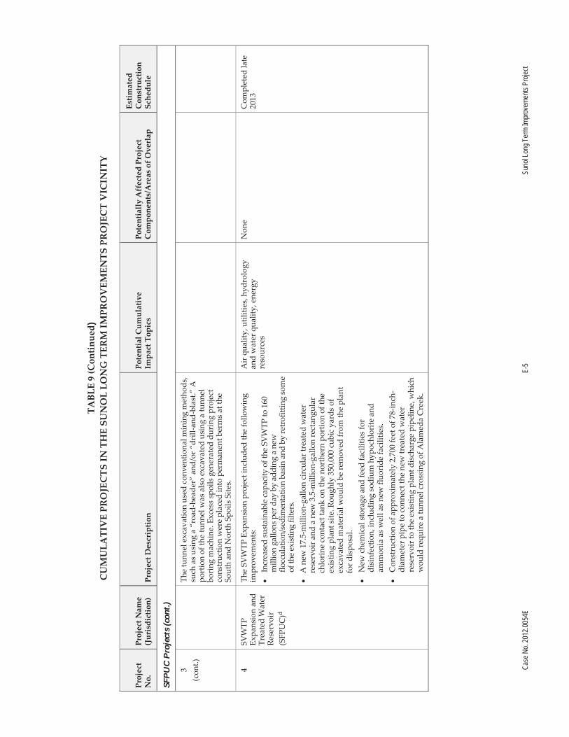
Case
No.
2012
.0054
E E-
5 Su
nol L
ong T
erm
Impr
ovem
ents
Proje
ct
TABL
E 9
(Con
tinu
ed)
CU
MU
LATI
VE
PRO
JEC
TS
IN T
HE
SUN
OL
LON
G T
ERM
IMPR
OV
EMEN
TS P
RO
JEC
T V
ICIN
ITY
Proj
ect
No.
Pr
ojec
t Nam
e (J
uris
dict
ion)
Pr
ojec
t Des
crip
tion
Po
tent
ial C
umul
ativ
e
Impa
ct T
opic
s Po
tent
iall
y A
ffec
ted
Proj
ect
Com
pone
nts/
Are
as o
f Ove
rlap
Esti
mat
ed
Con
stru
ctio
n Sc
hedu
le
SFPU
C P
roje
cts
(con
t.)
3 (c
ont.)
The
tunn
el e
xcav
atio
n us
ed c
onve
ntio
nal m
inin
g m
etho
ds,
such
as u
sing
a “
road
-hea
der”
and
/or “
drill
-and
-bla
st.”
A
port
ion
of th
e tu
nnel
was
als
o ex
cava
ted
usin
g a
tunn
el
bori
ng m
achi
ne. E
xces
s sp
oils
gen
erat
ed d
urin
g pr
ojec
t co
nstr
uctio
n w
ere
plac
ed in
to p
erm
anen
t ber
ms a
t the
So
uth
and
Nor
th S
poils
Site
s.
4 SV
WTP
Ex
pans
ion
and
Trea
ted
Wat
er
Rese
rvoi
r (S
FPU
C)d
The
SVW
TP E
xpan
sion
pro
ject
incl
uded
the
follo
win
g im
prov
emen
ts:
Incr
ease
d su
stai
nabl
e ca
paci
ty o
f the
SV
WTP
to 1
60
mill
ion
gallo
ns p
er d
ay b
y ad
ding
a n
ew
flocc
ulat
ion/
sedi
men
tatio
n ba
sin
and
by re
trof
ittin
g so
me
of th
e ex
istin
g fil
ters
. A
new
17.
5-m
illio
n-ga
llon
circ
ular
trea
ted
wat
er
rese
rvoi
r and
a n
ew 3
.5-m
illio
n-ga
llon
rect
angu
lar
chlo
rine
con
tact
tank
on
the
nort
hern
por
tion
of th
e ex
istin
g pl
ant s
ite. R
ough
ly 3
50,0
00 c
ubic
yar
ds o
f ex
cava
ted
mat
eria
l wou
ld b
e re
mov
ed fr
om th
e pl
ant
for d
ispo
sal.
N
ew c
hem
ical
sto
rage
and
feed
faci
litie
s for
di
sinf
ectio
n, in
clud
ing
sodi
um h
ypoc
hlor
ite a
nd
amm
onia
as w
ell a
s new
fluo
ride
faci
litie
s. C
onst
ruct
ion
of a
ppro
xim
atel
y 2,
700
feet
of 7
8-in
ch-
diam
eter
pip
e to
con
nect
the
new
trea
ted
wat
er
rese
rvoi
r to
the
exis
ting
plan
t dis
char
ge p
ipel
ine,
whi
ch
wou
ld re
quir
e a
tunn
el c
ross
ing
of A
lam
eda
Cre
ek.
Air
qua
lity,
util
ities
, hyd
rolo
gy
and
wat
er q
ualit
y, e
nerg
y re
sour
ces
Non
e C
ompl
eted
late
20
13

Case
No.
2012
.0054
E E-
6 Su
nol L
ong T
erm
Impr
ovem
ents
Proje
ct
TABL
E 9
(Con
tinu
ed)
CU
MU
LATI
VE
PRO
JEC
TS
IN T
HE
SUN
OL
LON
G T
ERM
IMPR
OV
EMEN
TS P
RO
JEC
T V
ICIN
ITY
Proj
ect
No.
Pr
ojec
t Nam
e (J
uris
dict
ion)
Pr
ojec
t Des
crip
tion
Po
tent
ial C
umul
ativ
e
Impa
ct T
opic
s Po
tent
iall
y A
ffec
ted
Proj
ect
Com
pone
nts/
Are
as o
f Ove
rlap
Esti
mat
ed
Con
stru
ctio
n Sc
hedu
le
SFPU
C P
roje
cts
(con
t.)
4 (c
ont.)
Mis
cella
neou
s pla
nt im
prov
emen
ts, i
nclu
ding
: a n
ew
emer
genc
y ge
nera
tor a
nd im
prov
emen
ts to
the
plan
t el
ectr
ical
syst
em a
nd su
bsta
tion;
an
upgr
ade
of th
e in
stru
men
tatio
n an
d co
ntro
ls; a
new
filte
r was
hwat
er
reco
very
bas
in; i
mpr
ovem
ents
to th
e flo
w d
istr
ibut
ion
stru
ctur
e an
d as
soci
ated
faci
litie
s; im
prov
emen
ts to
the
influ
ent c
hem
ical
mix
ing
syst
em; a
nd re
plac
emen
t in-
kind
of e
xist
ing
chem
ical
tank
s. H
abita
t cre
atio
n an
d re
stor
atio
n ac
tions
on
CC
SF-o
wne
d la
nds t
hat a
re z
oned
for a
gric
ultu
ral u
ses a
nd/o
r lea
sed
for g
razi
ng la
nds.
5 Sa
n A
nton
io
Pum
p St
atio
n U
pgra
de
(SFP
UC
)e
This
pro
ject
repl
aced
thre
e co
rrod
ed e
lect
rical
pum
ps w
ith
thre
e 1,
000-
hors
epow
er e
lect
rical
pum
ps; i
nsta
lled
two
1.5-
meg
awat
t sta
ndby
ele
ctric
al g
ener
ator
s and
seis
mic
ally
re
trof
itted
the
exis
ting
pum
p st
atio
n bu
ildin
g by
ext
endi
ng
the
foun
datio
n an
d sh
otcr
etin
g th
e bu
ildin
g ex
terio
r. Tw
o te
mpo
rary
stag
ing
area
s wer
e lo
cate
d ad
jace
nt to
the
San
Ant
onio
Pum
p St
atio
n an
d th
e Su
nol V
alle
y C
hlor
amin
atio
n Fa
cilit
y. N
o gr
adin
g or
exc
avat
ion
was
nec
essa
ry to
ac
com
mod
ate
the
prop
osed
stag
ing
area
s.
Air
qua
lity,
bio
logi
cal r
esou
rces
, hy
drol
ogy
and
wat
er q
ualit
y N
one
Com
plet
ed
late
201
0

Case
No.
2012
.0054
E E-
7 Su
nol L
ong T
erm
Impr
ovem
ents
Proje
ct
TABL
E 9
(Con
tinu
ed)
CU
MU
LATI
VE
PRO
JEC
TS
IN T
HE
SUN
OL
LON
G T
ERM
IMPR
OV
EMEN
TS P
RO
JEC
T V
ICIN
ITY
Proj
ect
No.
Pr
ojec
t Nam
e (J
uris
dict
ion)
Pr
ojec
t Des
crip
tion
Po
tent
ial C
umul
ativ
e
Impa
ct T
opic
s Po
tent
iall
y A
ffec
ted
Proj
ect
Com
pone
nts/
Are
as o
f Ove
rlap
Esti
mat
ed
Con
stru
ctio
n Sc
hedu
le
SFPU
C P
roje
cts
(con
t.)
6 [V
ario
us
loca
tion
s]
Var
ious
Pi
peli
ne
Insp
ecti
on
Proj
ects
(S
FPU
C)f
SFPU
C p
ipel
ine
insp
ecti
ons
cons
ist o
f int
erna
l ev
alua
tions
of t
he p
ipe
netw
ork.
Pip
elin
es a
re a
cces
sed
via
exis
ting
acce
ss p
orts
. It i
s ne
cess
ary
to d
ewat
er th
e pi
pe b
efor
e th
e in
spec
tion,
and
late
r dis
infe
ct th
e pi
pe
befo
re re
filli
ng it
. The
pip
es a
re ty
pica
lly
dew
ater
ed
thro
ugh
exis
ting
air v
alve
s; d
isch
arge
s ar
e m
ade
in
acco
rdan
ce w
ith a
n ex
istin
g N
PDES
per
mit
for t
he
SFPU
C d
rink
ing
wat
er tr
ansm
issi
on s
yste
m (R
WQ
CB
Ord
er N
o. R
2-20
08-0
102)
, and
wou
ld b
e su
bjec
t to
insp
ectio
n an
d w
ater
qua
lity
BMPs
. In
rare
cas
es, a
m
inor
am
ount
of e
xcav
atio
n m
ay b
e ne
cess
ary
to g
ain
acce
ss to
the
pipe
line
. Pip
elin
es th
at c
ould
requ
ire
insp
ectio
n in
the
Suno
l Val
ley
incl
ude
the
San
Ant
onio
Pi
pelin
e, C
alav
eras
Pip
elin
e, a
nd A
lam
eda
Siph
ons
Nos
. 1, 2
, and
3, w
ith d
ewat
erin
g di
scha
rges
to e
ither
San
A
nton
io o
r Ala
med
a C
reek
s.
Air
qua
lity,
hyd
rolo
gy a
nd w
ater
qu
ality
, N
one
Ong
oing
7 Sa
n A
nton
io
Rese
rvoi
r H
ypol
imne
tic
Oxy
gena
tion
Syst
em
(SFP
UC
)g
This
pro
ject
incl
uded
des
ign
to re
duce
exc
essi
ve b
uild
up
of n
utri
ents
in th
e de
epes
t lay
er o
f wat
er in
San
Ant
onio
Re
serv
oir,
ther
eby
inhi
bitin
g fu
ture
alg
al b
loom
s; re
duce
th
e fo
rmat
ion
of ir
on, m
anga
nese
, and
hyd
roge
n su
lfide
th
at re
sults
from
a la
ck o
f oxy
gen
in th
e re
serv
oir;
and
mai
ntai
n ne
cess
ary
oxyg
en c
once
ntra
tion
in th
e de
epes
t la
yers
of t
he re
serv
oir t
o in
crea
se th
e us
able
hab
itat f
or
cold
-wat
er fi
sh. P
roje
ct c
ompo
nent
s in
clud
ed c
oncr
ete
pads
for f
acili
ties,
park
ing,
and
acc
ess
road
s; ta
nks;
va
pori
zers
; val
ves;
pip
ing
and
o the
r ass
ocia
ted
stru
ctur
es;
unde
rgro
und
elec
tric
al s
uppl
y lin
e; a
nd o
xyge
n lin
es a
nd
diffu
sers
sus
pend
ed a
t spe
cifie
d de
pths
in th
e re
serv
oir.
Hyd
rolo
gy a
nd w
ater
qua
lity
Non
e C
ompl
eted
late
20
09

Case
No.
2012
.0054
E E-
8 Su
nol L
ong T
erm
Impr
ovem
ents
Proje
ct
TABL
E 9
(Con
tinu
ed)
CU
MU
LATI
VE
PRO
JEC
TS
IN T
HE
SUN
OL
LON
G T
ERM
IMPR
OV
EMEN
TS P
RO
JEC
T V
ICIN
ITY
Proj
ect
No.
Pr
ojec
t Nam
e (J
uris
dict
ion)
Pr
ojec
t Des
crip
tion
Po
tent
ial C
umul
ativ
e
Impa
ct T
opic
s Po
tent
iall
y A
ffec
ted
Proj
ect
Com
pone
nts/
Are
as o
f Ove
rlap
Esti
mat
ed
Con
stru
ctio
n Sc
hedu
le
SFPU
C P
roje
cts
(con
t.)
8 C
alav
eras
Dam
R
epla
cem
ent
(SFP
UC
)h
The
proj
ect p
rovi
des
for p
lann
ing,
des
ign,
and
co
nstr
uctio
n of
a re
plac
emen
t dam
at t
he C
alav
eras
R
eser
voir
to m
eet s
eism
ic sa
fety
requ
irem
ents
. Whe
n co
mpl
ete,
the
new
dam
wou
ld p
rovi
de fo
r a re
serv
oir w
ith
the
sam
e st
orag
e ca
paci
ty a
s the
ori
gina
l res
ervo
ir (9
6,85
0 ac
re-f
eet),
but
the
repl
acem
ent d
am w
ould
acc
omm
odat
e a
pote
ntia
l enl
arge
men
t of t
he d
am in
the
futu
re. T
he
proj
ect i
nclu
des
the
follo
win
g im
prov
emen
ts:
Reg
radi
ng o
f the
exi
stin
g da
m a
nd c
onst
ruct
ion
of a
ne
w e
arth
and
rock
-fill
dam
. R
epla
cem
ent o
f the
exi
stin
g sp
illw
ay, s
tilli
ng b
asin
, an
d in
take
tow
er to
incr
ease
sei
smic
saf
ety
and
impr
ove
oper
atio
ns a
nd m
aint
enan
ce.
Inst
alla
tion
of n
ew o
utle
t val
ves
at th
e ba
se o
f the
da
m fo
r fis
hery
rele
ases
and
inst
alla
tion
of fi
sh
scre
ens
on th
e ex
istin
g ad
its.
Con
stru
ctio
n-re
late
d tr
affi
c,
nois
e, a
ir q
uali
ty, u
tiliti
es,
biol
ogic
al re
sour
ces,
hyd
rolo
gy
and
wat
er q
ualit
y, h
azar
ds a
nd
haza
rdou
s m
ater
ials
, ene
rgy
reso
urce
s
Non
e 20
11 to
201
7

Case
No.
2012
.0054
E E-
9 Su
nol L
ong T
erm
Impr
ovem
ents
Proje
ct
TABL
E 9
(Con
tinu
ed)
CU
MU
LATI
VE
PRO
JEC
TS
IN T
HE
SUN
OL
LON
G T
ERM
IMPR
OV
EMEN
TS P
RO
JEC
T V
ICIN
ITY
Proj
ect
No.
Pr
ojec
t Nam
e (J
uris
dict
ion)
Pr
ojec
t Des
crip
tion
Po
tent
ial C
umul
ativ
e
Impa
ct T
opic
s Po
tent
iall
y A
ffec
ted
Proj
ect
Com
pone
nts/
Are
as o
f Ove
rlap
Esti
mat
ed
Con
stru
ctio
n Sc
hedu
le
SFPU
C P
roje
cts
(con
t.)
8 (c
ont.)
Con
stru
ctio
n of
a b
ypas
s tu
nnel
at t
he A
lam
eda
Cre
ek D
iver
sion
Dam
(AC
DD
), a
fish
scr
een
on th
e A
lam
eda
Cre
ek D
iver
sion
Tun
nel,
and
a fi
sh la
dder
ar
ound
the
AC
DD
. N
ew o
r reh
abili
tate
d ou
tlet w
orks
. U
pgra
ding
of t
he e
lect
rica
l dis
trib
utio
n lin
e be
twee
n M
ilpi
tas
and
Cal
aver
as D
am.
Long
-ter
m im
plem
enta
tion
of m
inim
um in
stre
am
flow
sch
edul
es fo
r Ala
med
a C
reek
bel
ow th
e A
CD
D
and
for C
alav
eras
Cre
ek b
elow
Cal
aver
as D
am.
Hab
itat c
reat
ion
and
rest
orat
ion
actio
ns o
n C
CSF
-ow
ned
land
s th
at a
re z
oned
for a
gric
ultu
ral u
ses
and/
or le
ased
for g
razi
ng la
nds.
9 G
eary
Roa
d Br
idge
Re
plac
emen
t (S
FPU
C)i
The
proj
ect i
nclu
des
repl
acem
ent o
f the
exi
stin
g tim
ber
brid
ge a
nd c
onst
ruct
ion
of a
new
ste
el b
ridg
e w
here
Gea
ry
Road
cro
sses
Ala
med
a C
reek
in th
e Su
nol R
egio
nal
Wild
erne
ss o
n la
nds
owne
d by
CC
SF a
nd o
pera
ted
by th
e Ea
st B
ay R
egio
nal P
ark
Dis
tric
t.
Air
qua
lity,
bio
logi
cal r
esou
rces
, hy
drol
ogy
and
wat
er q
ualit
y,
ener
gy re
sour
ces
Non
e C
ompl
eted
201
4
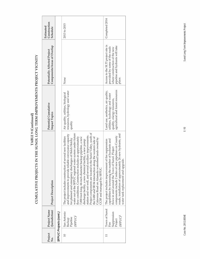
Case
No.
2012
.0054
E E-
10
Suno
l Lon
g Ter
m Im
prov
emen
ts Pr
oject
TABL
E 9
(Con
tinu
ed)
CU
MU
LATI
VE
PRO
JEC
TS
IN T
HE
SUN
OL
LON
G T
ERM
IMPR
OV
EMEN
TS P
RO
JEC
T V
ICIN
ITY
Proj
ect
No.
Pr
ojec
t Nam
e (J
uris
dict
ion)
Pr
ojec
t Des
crip
tion
Po
tent
ial C
umul
ativ
e
Impa
ct T
opic
s Po
tent
iall
y A
ffec
ted
Proj
ect
Com
pone
nts/
Are
as o
f Ove
rlap
Esti
mat
ed
Con
stru
ctio
n Sc
hedu
le
SFPU
C P
roje
cts
(con
t.)
10
San
Ant
onio
Ba
ckup
Pi
pelin
e (S
FPU
C)j
The
proj
ect i
nclu
des c
onst
ruct
ion
of se
vera
l new
faci
litie
s an
d im
prov
emen
ts to
pro
vide
relia
ble
conv
eyan
ce c
apac
ity
for p
lann
ed a
nd e
mer
genc
y di
scha
rges
of H
etch
Het
chy
wat
er o
ut o
f the
SFP
UC
regi
onal
wat
er sy
stem
und
er fu
ture
flo
w c
ondi
tions
. Con
stru
ctio
n in
clud
es a
n ap
prox
imat
ely
7,00
0-fo
ot-lo
ng, 6
6-in
ch-d
iam
eter
bac
kup
pipe
line,
a n
ew
disc
harg
e fa
cilit
y, a
new
che
mic
al fa
cilit
y, a
new
pum
p st
atio
n an
d w
et w
ell,
and
seve
ral a
uxili
ary
impr
ovem
ents
. Pr
ojec
t com
pone
nts a
re lo
cate
d in
the
Suno
l Val
ley,
sout
h of
th
e I-6
80 a
nd S
R 84
inte
rsec
tion
alon
g th
e w
este
rn si
de o
f C
alav
eras
Roa
d on
Ala
med
a w
ater
shed
land
s ow
ned
by
CC
SF a
nd m
anag
ed b
y SF
PUC
.
Air
qua
lity,
util
ities
, bio
logi
cal
reso
urce
s, hy
drol
ogy
and
wat
er
qual
ity
Non
e 20
13 to
201
5
11
Tow
n of
Sun
ol
Fire
Su
ppre
ssio
n Pr
ojec
t (S
FPU
C)k
The
proj
ect i
nclu
des i
mpr
ovem
ent o
f fir
e su
ppre
ssio
n ca
pabi
litie
s by
incr
easi
ng th
e nu
mbe
r of h
ydra
nts
and
flow
s in
and
arou
nd th
e To
wn
of S
unol
. Pro
ject
co
mpo
nent
s in
clud
e 2
mile
s of n
ew p
ipel
ines
on
Cou
nty
road
s, in
stal
latio
n of
app
roxi
mat
ely
26 n
ew h
ydra
nts,
and
w
ater
tank
repl
acem
ent a
nd u
pgra
de.
Land
use
, aes
thet
ics,
air q
ualit
y,
utili
ties,
hyd
rolo
gy a
nd w
ater
qu
ality
, ene
rgy
reso
urce
s,
agri
cultu
ral a
nd fo
rest
reso
urce
s
Acc
ess
to th
e SL
TI p
roje
ct si
te is
pr
ovid
ed b
y so
me
of th
e ro
ads
whe
re c
onst
ruct
ion
of th
e ne
w
pipe
line
and
hydr
ants
will
take
pl
ace.
Com
plet
ed 2
014
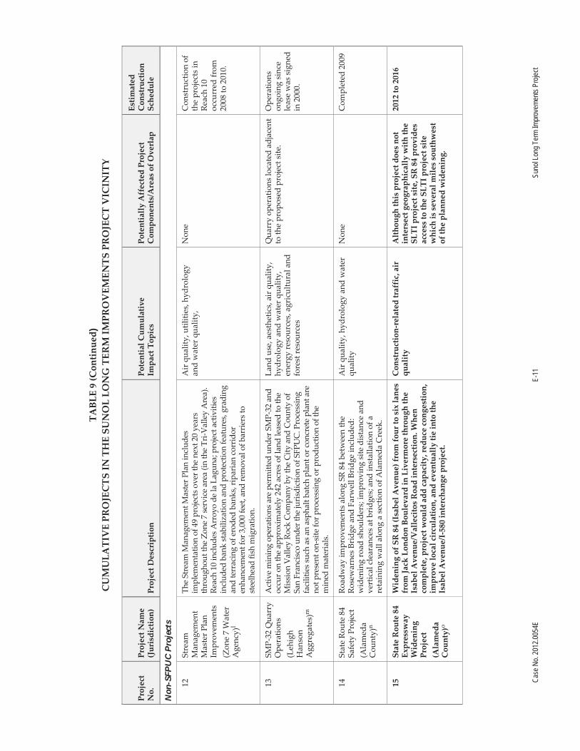
Case
No.
2012
.0054
E E-
11
Suno
l Lon
g Ter
m Im
prov
emen
ts Pr
oject
TABL
E 9
(Con
tinu
ed)
CU
MU
LATI
VE
PRO
JEC
TS
IN T
HE
SUN
OL
LON
G T
ERM
IMPR
OV
EMEN
TS P
RO
JEC
T V
ICIN
ITY
Proj
ect
No.
Pr
ojec
t Nam
e (J
uris
dict
ion)
Pr
ojec
t Des
crip
tion
Po
tent
ial C
umul
ativ
e
Impa
ct T
opic
s Po
tent
iall
y A
ffec
ted
Proj
ect
Com
pone
nts/
Are
as o
f Ove
rlap
Esti
mat
ed
Con
stru
ctio
n Sc
hedu
le
Non
-SFP
UC
Pro
ject
s
12
Stre
am
Man
agem
ent
Mas
ter P
lan
Impr
ovem
ents
(Z
one
7 W
ater
A
genc
y)l
The
Stre
am M
anag
emen
t Mas
ter P
lan
incl
udes
im
plem
enta
tion
of 4
9 pr
ojec
ts o
ver t
he n
ext 2
0 ye
ars
thro
ugho
ut th
e Zo
ne 7
serv
ice
area
(in
the
Tri- V
alle
y A
rea)
. Re
ach
10 in
clud
es A
rroy
o de
la L
agun
a; p
roje
ct a
ctiv
ities
in
clud
ed b
ank
stab
iliza
tion
and
prot
ectio
n fe
atur
es, g
radi
ng
and
terr
acin
g of
ero
ded
bank
s, ri
paria
n co
rrid
or
enha
ncem
ent f
or 3
,000
feet
, and
rem
oval
of b
arrie
rs to
st
eelh
ead
fish
mig
ratio
n.
Air
qua
lity,
util
ities
, hyd
rolo
gy
and
wat
er q
ualit
y,
Non
e
Con
stru
ctio
n of
th
e pr
ojec
ts in
Re
ach
10
occu
rred
from
20
08 to
201
0.
13
SMP-
32 Q
uarr
y O
pera
tions
(L
ehig
h H
anso
n A
ggre
gate
s)m
Act
ive
min
ing
oper
atio
ns a
re p
erm
itted
und
er S
MP-
32 a
nd
occu
r on
the
appr
oxim
atel
y 24
2 ac
res o
f lan
d le
ased
to th
e M
issi
on V
alle
y Ro
ck C
ompa
ny b
y th
e C
ity a
nd C
ount
y of
Sa
n Fr
anci
sco
unde
r the
juris
dict
ion
of S
FPU
C. P
roce
ssin
g fa
cilit
ies s
uch
as a
n as
phal
t bat
ch p
lant
or c
oncr
ete
plan
t are
no
t pre
sent
on-
site
for p
roce
ssin
g or
pro
duct
ion
of th
e m
ined
mat
eria
ls.
Land
use
, aes
thet
ics,
air q
ualit
y,
hydr
olog
y an
d w
ater
qua
lity,
en
ergy
reso
urce
s , a
gric
ultu
ral a
nd
fore
st re
sour
ces
Qua
rry
oper
atio
ns lo
cate
d ad
jace
nt
to th
e pr
opos
ed p
roje
ct s
ite.
Ope
ratio
ns
ongo
ing
sinc
e le
ase
was
sig
ned
in 2
000.
14
Stat
e Ro
ute
84
Safe
ty P
roje
ct
(Ala
med
a C
ount
y)n
Road
way
impr
ovem
ents
alo
ng S
R 84
bet
wee
n th
e Ro
sew
arne
s Br
idge
and
Far
wel
l Bri
dge
incl
uded
: w
iden
ing
road
sho
ulde
rs; i
mpr
ovin
g si
te d
ista
nce
and
vert
ical
cle
aran
ces a
t bri
dges
; and
inst
alla
tion
of a
re
tain
ing
wal
l alo
ng a
sec
tion
of A
lam
eda
Cre
ek.
Air
qua
lity ,
hyd
rolo
gy a
nd w
ater
qu
ality
N
one
Com
plet
ed 2
009
15
Stat
e R
oute
84
Expr
essw
ay
Wid
enin
g Pr
ojec
t (A
lam
eda
Cou
nty)
o
Wid
enin
g of
SR
84
(Isa
bel A
venu
e) fr
om fo
ur to
six
lane
s fr
om Ja
ck L
ondo
n Bo
ulev
ard
in L
iver
mor
e th
roug
h th
e Is
abel
Ave
nue /
Val
leci
tos
Roa
d in
ters
ectio
n. W
hen
com
plet
e, p
roje
ct w
ould
add
cap
acity
, red
uce
cong
estio
n,
impr
ove
loca
l cir
cula
tion
, and
eve
ntua
lly
tie in
to th
e Is
abel
Ave
nue/
I-58
0 in
terc
hang
e pr
ojec
t.
Con
stru
ctio
n-re
late
d tr
affi
c, a
ir
qual
ity
Alt
houg
h th
is p
roje
ct d
oes
not
inte
rsec
t geo
grap
hica
lly
wit
h th
e SL
TI p
roje
ct s
ite, S
R 8
4 pr
ovid
es
acce
ss to
the
SLTI
pro
ject
site
w
hich
is s
ever
al m
iles
sout
hwes
t of
the
plan
ned
wid
enin
g.
2012
to 2
016

Case
No.
2012
.0054
E E-
12
Suno
l Lon
g Ter
m Im
prov
emen
ts Pr
oject
TABL
E 9
(Con
tinu
ed)
CU
MU
LATI
VE
PRO
JEC
TS
IN T
HE
SUN
OL
LON
G T
ERM
IMPR
OV
EMEN
TS P
RO
JEC
T V
ICIN
ITY
Proj
ect
No.
Pr
ojec
t Nam
e (J
uris
dict
ion)
Pr
ojec
t Des
crip
tion
Po
tent
ial C
umul
ativ
e
Impa
ct T
opic
s Po
tent
iall
y A
ffec
ted
Proj
ect
Com
pone
nts/
Are
as o
f Ove
rlap
Esti
mat
ed
Con
stru
ctio
n Sc
hedu
le
Non
-SFP
UC
Pro
ject
s (c
ont.)
16
I-68
0 H
igh
Occ
upan
cy
Veh
icle
Lan
e (A
lam
eda
Cou
nty)
p
This
pro
ject
incl
uded
con
stru
ctio
n of
a so
uthb
ound
and
no
rthb
ound
Hig
h-O
ccup
ancy
Veh
icle
lane
on
the
I-680
Su
nol g
rade
with
ram
p m
eter
ing
and
an a
uxili
ary
lane
fr
om S
R 84
to th
e M
onta
gue
Expr
essw
ay to
alle
viat
e tr
affic
co
nges
tion
alon
g I-
680.
Air
qua
lity,
hyd
rolo
gy a
nd w
ater
qu
ality
N
one
Com
plet
ed in
20
10
17
Ala
med
a C
reek
Br
idge
R
epla
cem
ent
Proj
ect
(Pre
viou
sly
the
“Sta
te R
oute
84
Nile
s C
anyo
n Sa
fety
Im
prov
emen
ts
Proj
ect”
) (A
lam
eda
Cou
nty)
q
This
pro
ject
wou
ld re
cons
truc
t the
exi
stin
g A
lam
eda
Cre
ek B
ridg
e (a
lso
calle
d th
e R
ichm
ond
Brid
ge) o
ver
Ala
med
a C
reek
in N
iles
Can
yon
in th
e C
ity o
f Fre
mon
t to
add
ress
ope
ratio
nal d
efic
ienc
ies
and
incr
ease
the
safe
ty o
f the
trav
elin
g pu
blic
. The
pro
ject
wou
ld a
lso
real
ign
the
road
way
to th
e w
est o
f the
bri
dge
for a
leng
th
of a
ppro
xim
atel
y 12
00 fe
et, t
o co
rrec
t the
sha
rp c
urve
on
the
exis
ting
bri
dge
appr
oach
. The
pro
ject
wou
ld im
prov
e tr
affi
c sa
fety
by
impr
ovin
g si
ght d
ista
nces
, upd
atin
g ba
rrie
r rai
ls, a
nd p
rovi
ding
a s
tand
ard
road
sho
ulde
r w
idth
.
Air
qua
lity,
util
ities
, hyd
rolo
gy
and
wat
er q
ualit
y Th
is p
roje
ct is
loca
ted
a fe
w m
iles
wes
t of t
he S
LTI p
roje
ct. A
cces
s to
the
SLTI
pro
ject
site
is
prov
ided
by
the
segm
ent o
f SR
84
unde
rgoi
ng im
prov
emen
t.
2017
to 2
018
18
PG&
E G
as
Pipe
line
C
ross
ing
(PG
&E)
r
This
pro
ject
wou
ld m
odif
y th
e ce
men
t-arm
ored
PG
&E
gas
pipe
line
cros
sing
of A
lam
eda
Cre
ek in
the
Suno
l V
alle
y ab
ove
the
conf
luen
ce o
f San
Ant
onio
Cre
ek,
whi
ch w
ould
elim
inat
e a
barr
ier t
o fi
sh m
igra
tion
at
mos
t cre
ek fl
ow le
vels
. The
pro
ject
invo
lves
m
odif
icat
ion
of th
e co
ncre
te m
at o
r con
stru
ctio
n of
a fi
sh
ladd
er to
all
ow fi
sh p
assa
ge.
Con
stru
ctio
n-re
late
d tr
affi
c,
nois
e, a
ir q
uali
ty, u
tiliti
es,
hydr
olog
y an
d w
ater
qua
lity
Non
e 20
15

Case
No.
2012
.0054
E E-
13
Suno
l Lon
g Ter
m Im
prov
emen
ts Pr
oject
TABL
E 9
(Con
tinu
ed)
CU
MU
LATI
VE
PRO
JEC
TS
IN T
HE
SUN
OL
LON
G T
ERM
IMPR
OV
EMEN
TS P
RO
JEC
T V
ICIN
ITY
Proj
ect
No.
Pr
ojec
t Nam
e (J
uris
dict
ion)
Pr
ojec
t Des
crip
tion
Po
tent
ial C
umul
ativ
e
Impa
ct T
opic
s Po
tent
iall
y A
ffec
ted
Proj
ect
Com
pone
nts/
Are
as o
f Ove
rlap
Esti
mat
ed
Con
stru
ctio
n Sc
hedu
le
Non
-SFP
UC
Pro
ject
s (c
ont.)
19
Rub
ber D
am
No.
1 a
nd
BAR
T W
eir
Fish
Pas
sage
Pr
ojec
t (A
CW
D a
nd
Ala
med
a C
ount
y Fl
ood
Con
trol
and
W
ater
C
onse
rvat
ion
Dis
tric
t)s
Whe
n co
mpl
ete,
this
pro
ject
wou
ld in
stal
l a fi
sh la
dder
in
the
city
of F
rem
ont a
t the
AC
WD
’s R
ubbe
r Dam
No.
1
and
Bay
Are
a R
apid
Tra
nspo
rtat
ion
(BA
RT)
wei
r to
faci
litat
e fi
sh m
igra
tion
in lo
wer
Ala
med
a C
reek
.
Air
qua
lity,
hyd
rolo
gy a
nd w
ater
qu
alit
y, h
azar
ds a
nd h
azar
dous
m
ater
ials
Non
e 20
14 to
201
5
20
Ala
med
a C
ount
y Fi
re
Dep
artm
ent
Suno
l Pro
ject
(A
lam
eda
Cou
nty
Fire
D
epar
tmen
t)t
AC
FD p
ropo
ses
to b
uild
a F
ire
Stat
ion
in S
unol
on
Palo
ma
Way
app
roxi
mat
ely
one
half
mile
wes
t of
Inte
rsta
te 6
80. T
he p
roje
ct in
clud
es a
pre
-fab
rica
ted
2,00
0 sq
uare
-foo
t fir
e st
atio
n an
d a
2,50
0 sq
uare
-foo
t gar
age
adja
cent
to th
e m
ain
buil
ding
.
Land
use
, aes
thet
ics,
co
nstr
ucti
on-r
elat
ed tr
affi
c, n
oise
, ai
r qua
lity,
util
itie
s, h
azar
ds a
nd
haza
rdou
s m
ater
ials
, ene
rgy
reso
urce
s , a
gric
ultu
ral a
nd fo
rest
re
sour
ces
The
proj
ect s
ite is
loca
ted
appr
oxim
atel
y 50
0 fe
et e
ast a
nd
acro
ss th
e st
reet
from
the
entr
ance
to
the
SLTI
pro
ject
site
on
Palo
ma
Way
.
2015
to 2
016

Case
No.
2012
.0054
E E-
14
Suno
l Lon
g Ter
m Im
prov
emen
ts Pr
oject
TABL
E 9
(Con
tinu
ed)
CU
MU
LATI
VE
PRO
JEC
TS
IN T
HE
SUN
OL
LON
G T
ERM
IMPR
OV
EMEN
TS P
RO
JEC
T V
ICIN
ITY
Proj
ect
No.
Pr
ojec
t Nam
e (J
uris
dict
ion)
Pr
ojec
t Des
crip
tion
Po
tent
ial C
umul
ativ
e
Impa
ct T
opic
s Po
tent
iall
y A
ffec
ted
Proj
ect
Com
pone
nts/
Are
as o
f Ove
rlap
Esti
mat
ed
Con
stru
ctio
n Sc
hedu
le
Not
es:
Bold
text
indi
cate
s th
at a
cum
ulat
ive
proj
ect’s
con
stru
ctio
n sc
hedu
le c
ould
ove
rlap
with
the
SLTI
pro
ject
con
stru
ctio
n sc
hedu
le.
AC
DD
= A
lam
eda
Cre
ek D
iver
sion
Dam
N
IT =
New
Irvi
ngto
n Tu
nnel
A
CFD
= A
lam
eda
Cou
nty
Fire
Dep
artm
ent
NPD
ES =
Nat
iona
l Pol
luta
nt D
isch
arge
Elim
inat
ion
Syst
em
AC
WD
= A
lam
eda
Cou
nty
Wat
er D
istr
ict
PG&
E =
Paci
fic G
as a
nd E
lect
ric
Com
pany
A
CTI
A =
Ala
med
a C
ount
y Tr
ansp
orta
tion
Impr
ovem
ents
Aut
hori
ty
RWQ
CB
= Re
gion
al W
ater
Qua
lity
Con
trol
Boa
rd
BART
= B
ay A
rea
Rapi
d Tr
ansi
t SF
PUC
= S
an F
ranc
isco
Pub
lic U
tiliti
es C
omm
issi
on
BMP
= be
st m
anag
emen
t pra
ctic
e SL
TI =
Sun
ol L
ong
Term
Impr
ovem
ents
C
altr
ans =
Cal
iforn
ia D
epar
tmen
t of T
rans
port
atio
n SR
= S
tate
Rou
te
CC
SF =
City
and
Cou
nty
of S
an F
ranc
isco
SV
WTP
= S
unol
Val
ley
Wat
er T
reat
men
t Pla
nt
I- =
Inte
rsta
te
Sour
ces:
a S
FPU
C, 2
013.
WSI
P Re
gion
al P
rojec
ts Q
uart
erly
Rep
ort,
4th
Qua
rter
/Fisc
al Y
ear 2
012-
2013
. Aug
ust 6
, 201
3.
b San
Fra
ncis
co P
lann
ing
Dep
artm
ent,
2008
. Ini
tial S
tudy
/Miti
gate
d N
egat
ive D
ecla
ratio
n, S
FPU
C A
lam
eda
Siph
ons S
eism
ic R
eliab
ility
Upg
rade
Pro
ject.
San
Fran
cisc
o Pl
anni
ng
Dep
artm
ent F
ile N
o. 2
006.
0776
E. M
ay.
c San
Fra
ncis
co P
lann
ing
Dep
artm
ent,
2009
. Fin
al E
nviro
nmen
tal I
mpa
ct R
epor
t for
the S
an F
ranc
isco
Publ
ic U
tiliti
es C
omm
issio
n N
ew Ir
ving
ton
Tunn
el P
rojec
t. Sa
n Fr
anci
sco
Plan
ning
Dep
artm
ent F
ile N
o. 2
005.
0162
E, S
tate
Cle
arin
ghou
se N
o. 2
0060
9208
5. N
ovem
ber 5
; SFP
UC
, 201
3. W
SIP
Regi
onal
Pro
ject
s Q
uart
erly
Rep
ort,
2nd
Qua
rter
/Fis
cal
Year
201
2-20
13. F
ebru
ary
5.
d Sa
n Fr
anci
sco
Plan
ning
Dep
artm
ent,
2009
. Fin
al E
nviro
nmen
tal I
mpa
ct R
epor
t for
the S
an F
ranc
isco
Publ
ic U
tiliti
es C
omm
issio
n Su
nol V
alley
Wat
er T
reat
men
t Pla
nt E
xpan
sion
and
Tr
eate
d W
ater
Res
ervo
ir Pr
ojec
t. Sa
n Fr
anci
sco
Plan
ning
Dep
artm
ent F
ile N
o. 2
006.
0137
E, S
tate
Cle
arin
ghou
se N
o. 2
0070
8201
4. D
ecem
ber 3
. e S
FPU
C, 2
014.
San
Ant
onio
Pum
p St
atio
n U
pgra
des,
Proj
ect U
pdat
e. A
vaila
ble
onlin
e at
: http
://21
6.11
9.10
4.14
5/bi
ds/p
roje
ctD
etai
l.asp
x?pr
j_id
=214
. Acc
esse
d A
ugus
t 201
4.
f San
Fra
ncis
co P
lann
ing
Dep
artm
ent,
2009
. Fin
al E
nviro
nmen
tal I
mpa
ct R
epor
t for
the S
an F
ranc
isco
Publ
ic U
tiliti
es C
omm
issio
n Su
nol V
alley
Wat
er T
reat
men
t Pla
nt E
xpan
sion
and
Tr
eate
d W
ater
Res
ervo
ir Pr
ojec
t, Sa
n Fr
anci
sco
Plan
ning
Dep
artm
ent F
ile N
o. 2
006.
0137
E, S
tate
Cle
arin
ghou
se N
o. 2
0070
8201
4. D
ecem
ber 3
. g S
an F
ranc
isco
Pla
nnin
g D
epar
tmen
t, 20
09. F
inal
Env
ironm
enta
l Im
pact
Rep
ort f
or th
e San
Fra
ncisc
o Pu
blic
Util
ities
Com
miss
ion
New
Irvi
ngto
n Tu
nnel
Proj
ect,
San
Fran
cisc
o Pl
anni
ng D
epar
tmen
t File
No.
200
5.01
62E,
Sta
te C
lear
ingh
ouse
No.
200
6092
085.
Nov
embe
r 5.
h SF
PUC
, 201
4. C
alav
eras
Dam
Rep
lace
men
t Pro
ject (
WSI
P) P
rojec
t Upd
ate.
Ava
ilabl
e on
line
at: h
ttp://
sfw
ater
.org
/bid
s/pr
ojec
tDet
ail.a
spx?
prj_
id=1
41. A
cces
sed
Aug
ust 2
014.

Case
No.
2012
.0054
E E-
15
Suno
l Lon
g Ter
m Im
prov
emen
ts Pr
oject
TABL
E 9
(Con
tinu
ed)
CU
MU
LATI
VE
PRO
JEC
TS
IN T
HE
SUN
OL
LON
G T
ERM
IMPR
OV
EMEN
TS P
RO
JEC
T V
ICIN
ITY
Proj
ect
No.
Pr
ojec
t Nam
e (J
uris
dict
ion)
Pr
ojec
t Des
crip
tion
Po
tent
ial C
umul
ativ
e
Impa
ct T
opic
s Po
tent
iall
y A
ffec
ted
Proj
ect
Com
pone
nts/
Are
as o
f Ove
rlap
Esti
mat
ed
Con
stru
ctio
n Sc
hedu
le
i San
Fra
ncis
co P
lann
ing
Dep
artm
ent,
2012
. Gea
ry R
oad
Brid
ge R
epla
cem
ent P
rojec
t Pre
limin
ary
Miti
gate
d N
egat
ive D
ecla
ratio
n. C
ase
No.
200
8.03
86E.
June
13;
SFP
UC
, 201
4. G
eary
Ro
ad B
ridge
, Pro
ject U
pdat
e. A
vaila
ble
onlin
e at
: http
://sfw
ater
.org
/bid
s/pr
ojec
tDet
ail.a
spx?
prj_
id=3
29. A
cces
sed
Aug
ust 2
014.
j S
an F
ranc
isco
Pla
nnin
g D
epar
tmen
t, 20
12. S
an A
nton
io B
acku
p Pi
pelin
e Pro
ject F
inal
Env
ironm
enta
l Im
pact
Rep
ort.
Cas
e N
o. 2
007.
0039
E. S
tate
Cle
arin
ghou
se N
o. 2
0071
0203
0.
Sept
embe
r 20;
SFP
UC
, 201
3. W
SIP
Regi
onal
Pro
jects
Qua
rter
ly R
epor
t, 4t
h Q
uart
er/F
iscal
Yea
r 201
2-20
13. A
ugus
t 6.
k SFP
UC
, 201
4. T
own
of S
unol
Fire
Sup
pres
sion
Syst
em P
rojec
t Fac
t She
et. A
vaila
ble
at: h
ttp://
sfwat
er.o
rg/m
odul
es/s
how
docu
men
t.asp
x?do
cum
entid
=514
9. A
pril
2014
. l L
iver
mor
e-A
mad
or V
alle
y Zo
ne 7
Wat
er A
genc
y, 2
006.
Zon
e 7 S
trea
m M
anag
emen
t Mas
ter P
lan
Fina
l Mas
ter E
nviro
nmen
tal I
mpa
ct R
epor
t. A
vaila
ble
onlin
e at
: ht
tp://
zone
7wat
er.s4
66.su
rese
rver
.com
/fina
l-sm
mp-
eir. A
ugus
t 200
6.
m S
FPU
C, 2
000.
Pub
lic U
tiliti
es C
omm
issio
n, S
an F
ranc
isco
Wat
er D
epar
tmen
t, Q
uarr
y Le
ase b
etw
een
City
and
Cou
nty
of S
an F
ranc
isco
as L
andl
ord,
and
Miss
ion
Valle
y Ro
ck C
ompa
ny,
as T
enan
t. Se
ptem
ber.
n
San
Fran
cisc
o Pl
anni
ng D
epar
tmen
t, 20
09. F
inal
Env
ironm
enta
l Im
pact
Rep
ort f
or th
e San
Fra
ncisc
o Pu
blic
Util
ities
Com
miss
ion
New
Irvi
ngto
n Tu
nnel
Proj
ect,
San
Fran
cisc
o Pl
anni
ng D
epar
tmen
t File
No.
200
5.01
62E,
Sta
te C
lear
ingh
ouse
No.
200
6092
085.
Nov
embe
r 5.
o Cal
tran
s, 2
008.
Sta
te R
oute
84
Expr
essw
ay W
iden
ing
Proj
ect I
nitia
l Stu
dy w
ith N
egat
ive D
ecla
ratio
n/En
viro
nmen
tal A
sses
smen
t with
Fin
ding
of N
o Si
gnifi
cant
Impa
ct. A
ugus
t 200
8;
AC
TIA
, 201
0. R
oute
84
Expr
essw
ay, A
CTIA
24,
Mon
thly
Rep
ort.
Apr
il.
p A
CTI
A, 2
011.
I-68
0 Su
nol E
xpre
ss L
anes
, ACT
IA 8
, Mon
thly
Rep
ort.
June
. q C
altr
ans,
201
0. N
iles C
anyo
n Sa
fety
Impr
ovem
ent P
rojec
t Dra
ft En
viro
nmen
tal I
mpa
ct R
epor
t/Env
ironm
enta
l Ass
essm
ent.
June
201
0.
r Ala
med
a C
reek
Alli
ance
, 201
4. S
unol
Val
ley, P
G&
E Pi
pelin
e Cro
ssin
g. A
vaila
ble
onlin
e at
: http
://w
ww
.ala
med
acre
ek.o
rg/r
esto
ratio
n-pr
ogre
ss/s
unol
-val
ley.p
hp. A
cces
sed
Febr
uary
11
, 201
4.
s AC
WD
, 201
4. C
urre
nt F
ish P
assa
ge &
Rela
ted
Proj
ects
, Rub
ber D
am N
o. 1
Rep
lace
men
t. A
vaila
ble
onlin
e at
: http
://w
ww
.acw
d.or
g/in
dex.
aspx
?NID
=456
. Acc
esse
d Fe
brua
ry 1
1,
2014
. t A
CFD
, 201
4. D
raft
Initi
al S
tudy
and
Pro
pose
d M
itiga
ted
Neg
ativ
e Dec
lara
tion,
Sun
ol F
ire S
tatio
n, S
unol
, Cal
iforn
ia. P
repa
red
by G
roun
d Zo
ne E
nvir
onm
enta
l Ser
vice
s. M
arch
20
14.

Case
No.
2012
.0054
E E-
16
Suno
l Lon
g Ter
m Im
prov
emen
ts Pr
oject
This
page
inte
ntio
nally
left
blan
k

Case No. 2012.0054E E-17 Sunol Long Term Improvements Project
Topics:
Potentially Significant
Impact
Less than Significant with
Mitigation Incorporated
Less-than-Significant
Impact No
Impact Not
Applicable
E.1 LAND USE AND LAND USE PLANNING— Would the project:
a) Physically divide an established community?
b) Conflict with any applicable land use plan, policy, or regulation of an agency with jurisdiction over the project (including, but not limited to the general plan, specific plan, local coastal program, or zoning ordinance) adopted for the purpose of avoiding or mitigating an environmental effect?
c) Have a substantial impact upon the existing character of the vicinity?
The project site is in a primarily rural setting, south of the Town of Sunol and west of the SR 84/
I-680 junction, in Alameda County, California. Adjoining the project site are gravel quarry
operations, the Sunol Water Temple Agricultural Park, Alameda Creek, and Arroyo de la
Laguna. Land uses in the project vicinity generally include open space and East Bay Regional
Park lands such as the Pleasanton Ridge Regional Park to the north and Sunol Regional
Wilderness to the south, as well as the urban uses of the greater San Francisco Bay Area.
The project site is designated as Water Management in the Alameda County General Plan. Land
uses adjacent to the project site include a quarry to the east, SR 84 and the Town of Sunol to the
north, Arroyo de la Laguna (Alameda Creek) and cultivated lands to the west, and the Sunol Golf
Course to the south. The area that the Watershed Center would be constructed on is SFPUC land,
including land leased to Mission Valley Rock Company, and operated by Lehigh Hanson. The
SFPUC lease with Mission Valley Rock Company would need to be modified in order to
construct the Watershed Center on that area. Overall land uses in the project vicinity are shown
on Figures 1 and 2. The majority of the site is developed with the existing Sunol Yard, Temple
Road, the Sunol Water Temple Agricultural Park, the Sunol Water Temple, a closed picnic area,
and water supply infrastructure, such as the Sunol Pump Station and Filter Galleries.
Impact LU-1: The project would not physically divide an established community. (No Impact)
The project is not in an established community, nor adjacent to a community that is expanding.
The project would be constructed on land owned by SFPUC and in use as a center for SFPUC’s

Case No. 2012.0054E E-18 Sunol Long Term Improvements Project
maintenance and support operations in the East Bay Area, an agricultural park, a quarry, and the
Sunol Water Temple. As a result, the project would not physically divide an established
community (No Impact).
Impact LU-2: The project would be consistent with applicable plans, policies, or regulations of an agency with jurisdiction over the project adopted for the purpose of avoiding or mitigating an environmental effect. (Less than Significant)
The proposed project facilities would not substantially alter existing land uses, because the
project site would still be used for operation of the Sunol Yard, the Sunol Water Temple
Agricultural Park, and visitor access to the Sunol Water Temple. With the exception of the
addition of the Watershed Center and reopening of the picnic area, no new uses are proposed on
the site.
As described in Section C, Compatibility with Existing Zoning and Plans, the project would not
obviously or substantially conflict with applicable plans, policies, and regulations. The new
Watershed Center would be compatible with, and would augment, the education purposes and
visitor experience of the Sunol Water Temple. The project site is designated as Water
Management in the Alameda County General Plan. Although CCSF is not legally bound by the
plans and policies of other jurisdictions for properties such as these, which are located in other
counties, the project is intended to, and would, serve the water management policies of SFPUC
by modernizing Sunol Yard and operations, which would facilitate improved maintenance of
water service operations. The project would also provide educational opportunities for the
public, with respect to watershed management and water services, which would help to promote
public awareness, appreciation, and understanding of water issues, water quality, and
conservation. Therefore, the project would not conflict with the plans, policies, or regulations of
CCSF, the SFPUC, or Alameda County, and impacts related to conflict with applicable land use
plans, policies, or regulations would be Less than Significant.
Impact LU-3: The project would not have a substantial impact upon the existing character of the project vicinity. (Less than Significant)
Construction
Project construction would consist of activities (e.g., excavation, use of construction equipment,
and construction traffic) that could result in increased traffic, noise, and emissions that, when
combined, could temporarily alter the character of existing open space, agricultural, or
recreational land uses. Potential physical environmental effects on surrounding land uses

Case No. 2012.0054E E-19 Sunol Long Term Improvements Project
resulting from implementation of the project are addressed in Section E.2, Aesthetics;
Section E.5, Transportation and Circulation; Section E.6, Noise; and Section E.7, Air Quality.
Because project construction activities would be temporary, would be limited in scale and
intensity, and confined to the existing project site, the impact on the existing character of the
vicinity would not be substantial. As described in Section A.5.6, Project Description, the SFPUC
would require advance coordination for access to the existing agricultural park for tours and
events, and would not allow public access to the Sunol Water Temple during construction
activities at the Sunol Yard or Watershed Center. Although these access restrictions could
continue for about 18 to 24 months during project construction, they would not result in any
long-term or permanent changes in land use. On completion of project construction, existing
access to land uses would be restored. Therefore, impacts on the existing character of the project
vicinity due to construction of the project would be Less than Significant.
Operation
Because it seeks to improve and continue the existing land uses at the project site, the project
would not result in a substantial change to existing land uses, or the permanent introduction of
new or incompatible land uses that would adversely affect surrounding areas. The project site is
developed with the Sunol Yard, the Sunol Water Temple Agricultural Park, a picnic area, and the
Sunol Water Temple, in addition to open and cultivated areas adjacent to the Lehigh Hanson
quarry. These types of land uses would continue at the project site. The addition of the new
Watershed Center in the area adjacent to the quarry would be compatible with these uses, though
the addition of the proposed Watershed Center would likely expand public use of and visitation
to the Sunol Water Temple site, an activity that is presently allowed. As discussed elsewhere in
this document, the anticipated increase in visitation to the site is not expected to cause significant
adverse traffic, air quality, biological, or other physical environmental impacts, and could have
beneficial social impacts in terms of enhanced recreational and educational opportunity. As
discussed in Section E.2, Aesthetics, the addition of the new Watershed Center would be in the
context of the Sunol Water Temple and Sunol Water Temple Agricultural Park, and would not
adversely alter the visual character of the project vicinity. Therefore, project operation and
maintenance activities would remain substantially consistent with current operations at these
facilities. Project operation and maintenance would therefore have a Less-than-Significant Impact
on nearby land uses.

Case No. 2012.0054E E-20 Sunol Long Term Improvements Project
Impact C-LU: The proposed project, in combination with past, present and reasonably foreseeable future projects in the vicinity of project sites, would not result in significant cumulative impacts related to land use. (Less than Significant)
The geographic scope for potential cumulative lands use impacts encompasses the area of the
project vicinity, which generally includes open space and park lands, quarry operations adjoining
the project site to the east that are leased to the Mission Valley Rock Company and operated by
Lehigh Hanson, as well as the Town of Sunol to the north. Cumulative projects listed in Table 9
above that are located within this geographic scope include the Town of Sunol Fire Suppression
Project, the SMP-32 Quarry Operations, and the Alameda County Fire Department Sunol Project.
As discussed previously, construction of the project could have a less-than-significant effect
regarding conflicts with applicable land use plans, policies, and regulations. Similarly, the
identified cumulative projects would also be required to comply with applicable land use plans,
policies, and regulations adopted for the purpose of minimizing an environmental effect.
Accordingly, no significant cumulative impact related to conflicts with applicable plans, policies
and regulations would result from the cumulative scenario to which the proposed project and
other cumulative projects would contribute (No Impact).
As detailed in Section E.2, Aesthetics, the Watershed Center and Sunol Yard improvements have
been designed to fit with the existing scale and setting, and would have a less-than-significant
effect on the existing character of the project vicinity. While the addition of fire hydrants and
increased flows associated with the Town of Sunol Fire Suppression Project would not change the
existing character of the project vicinity, the other two cumulative projects have or could alter the
character in the vicinity of the project site. The SMP-32 Quarry has substantially changed the existing
character of the project vicinity since operations began in early 2006. The Alameda County Fire
Department Sunol Project would develop a currently undeveloped parcel of land that would
contribute to a change in the existing character of the project vicinity. Therefore, although the other
projects would contribute to a cumulative land use impact associated with a change in the character
of the existing project vicinity, the proposed project would not fundamentally change existing uses
on the project site. Therefore, the incremental contribution of the proposed project to changes in land
use would not be cumulatively considerable (Less Than Significant).

Case No. 2012.0054E E-21 Sunol Long Term Improvements Project
Topics:
Potentially Significant
Impact
Less than Significant
with Mitigation
Incorporated
Less-than-Significant
Impact No
Impact Not
Applicable
E.2 AESTHETICS—Would the project:
a) Have a substantial adverse effect on a scenic vista?
b) Substantially damage scenic resources, including, but not limited to, trees, rock outcroppings, and other features of the built or natural environment which contribute to a scenic public setting?
c) Substantially degrade the existing visual character or quality of the site and its surroundings?
d) Create a new source of substantial light or glare which would adversely affect day or nighttime views in the area or which would substantially impact other people or properties?
Visual Setting and Visual Character
For purposes of this analysis, a 1-mile buffer surrounding the project site is defined as the Visual
Resource Study Area (study area), and is considered the area in which existing publically
accessible views could experience changes in visual character and quality (Figure 6). This buffer
distance was determined based on the limited height of the proposed structures associated with
the Watershed Center and Sunol Yard, which will all be one story (or less than 22 feet tall).
The study area is in the Pacific Mountain System, Pacific Border Province, and specifically, the
California Coast Range physiographic region.14 The California Coast Range physiographic region
is broadly characterized as a series of low north-south-trending mountains and valleys that
parallel the California coast.15 Topography of this system is generally rolling.
The project site is south of the Town of Sunol and west of the SR 84/I-680 junction. The project
site is in the Sunol Valley, and is distantly enclosed by rolling hillsides in all directions. Although
14 Physiographic regions are broad-scale subdivisions that share similar characteristics in terms of terrain texture, rock type, and geologic structure and history.
15 USGS, 2003. A Tapestry of Time and Terrain. Available online at: http://tapestry.usgs.gov/physiogr/physio.html. Accessed May 3, 2014.
Case No. 2012.0054E E-22 Sunol Long Term Improvements Project
mostly rural, man-made development such as agricultural oriented buildings, roadways, a golf
course, a quarry, and overhead power distribution and transmission lines are visible throughout
the study area (Figure 6). Visual resource analysts performed site visits on May 2, 2014, and
July 10, 2014, to capture images of the study area and inventory the existing visual character
within a 1-mile buffer of project.
To portray the existing visual character in the study area, visual resource analysts collected
digital photographic imagery from four publically accessible View Point locations (VPs). These
four VPs inventory the existing visual conditions in the Visual Resource Study Area, and
represent typical views in the study area, as viewed by sensitive viewer groups (see Figure 7).16
As evidenced by the imagery taken from the four VPs shown below, the rolling and roughly
triangular-shaped hillsides of the East Bay Hills serve to distantly enclose views in all directions
from the project site (Figures 8 through 11). The Visual Resource Study Area ranges in elevation
from a peak of 945 feet to a low of 238 feet, North American Vertical Datum (NAVD). The
hillsides surrounding the project are mostly undeveloped and naturally vegetated with annual
grassland or oak woodland habitat. Vegetation is concentrated in steep tree-lined drainages of
the hillsides. The foothills occasionally form sequenced peaks and valleys. This repetition of
form, combined with the mix of vegetation that covers the hillsides, demonstrates a high degree
of visual quality due to lack of encroachment from intervening elements and as a result of their
mostly unencumbered natural form. The surrounding hillsides and ridgelines are variable in
elevation, adding a sense of depth and mass to the scenery adjacent to the project site. Where
visible, the convergence of the surrounding hillsides with the valley floor creates a strong
horizontal edge. This converging edge is prominent and well-defined when not obscured by
structural development or other natural vegetative screening.17
16 Sensitive viewer groups are defined in the following subsection. 17 URS Site Reconnaissance, May 2, 2014 and July 10, 2014.

Case No. 2012.0054E E-23 Sunol Long Term Improvements Project
Figure 6
Visual Resource Study Area

Case No. 2012.0054E E-24 Sunol Long Term Improvements Project
Figure 7
Visual Resource View Point and/or Simulation Locations

Case No. 2012.0054E E-25 Sunol Long Term Improvements Project
Figure 8
VP 1 – Facing Southwest from SR 84 toward the Project Site
Figure 9
VP 2 – Facing South from the Entrance to Temple Road
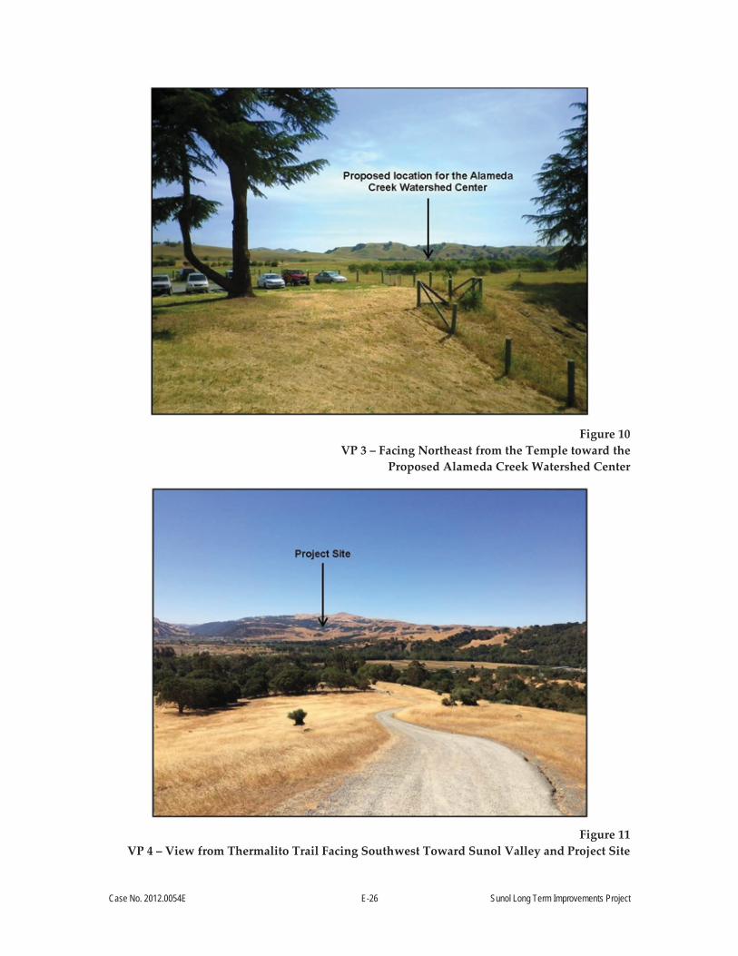
Case No. 2012.0054E E-26 Sunol Long Term Improvements Project
Figure 10
VP 3 – Facing Northeast from the Temple toward the Proposed Alameda Creek Watershed Center
Figure 11
VP 4 – View from Thermalito Trail Facing Southwest Toward Sunol Valley and Project Site
Case No. 2012.0054E E-27 Sunol Long Term Improvements Project
Affected Viewers and Visual Sensitivity
Potentially impacted viewers can be categorized into groups of shared sensitivity to changes in
the existing scenic quality of a landscape. Viewer sensitivity (or public concern) for the scenic
quality of a landscape or particular view is informed by the nature of the activity a user is
engaged in at the time something is visible. Further considerations include the number of
viewers, duration of exposure, and degree of public interest in a particular view. For example,
highly sensitive viewers are generally assumed to include residents, recreationists, and motorists
traveling on designated scenic highways. Less sensitive viewer groups are assumed to include
viewers from commercial or industrial type land uses, or recreational users using motorized
equipment such as off-highway vehicles. The project site is visible from three primary sensitive
viewer groups, including 1) visitors to the Sunol Water Temple;18 2) hikers traveling south on the
Thermalito Trail; and 3) motorists traveling east and west on SR 84.
Visitors to the Sunol Water Temple are assumed to be among the most sensitive viewer groups
with views of the site. Although their length of exposure is minimal overall, they are assumed to
be highly sensitive to changes in the existing visual character and quality of this historically
significant landscape/“scenic resource.”19
Viewers on Thermalito Trail are considered sensitive based on the recreational nature of the
activity they are engaged in when the project site is visible. Hikers are assumed to seek direct
connection with the natural environment, and therefore have elevated sensitivity to potentially
adverse changes in existing visual quality.
Motorists traveling on SR 84 are considered sensitive because SR 84 is a Caltrans-Designated
Scenic Highway.20 SR 84 is also a Locally Designated Scenic Road, according to the Scenic
18 Viewers traveling on Temple Drive whose primary objective is to see and experience the Sunol Water Temple.
19 Additional information pertaining to the historic significance of this structure may be found in Section E.4, Cultural and Paleontological Resources, of this Initial Study, as well as in the Historic Resource Inventory Evaluation Report prepared for the Sunol Division Headquarters Complex and Sunol Water Temple Update, prepared by JRP and dated 2010.
20 Caltrans, 2013. Eligible and Officially Designated Scenic Highway Routes. Available online at: http://www.dot.ca.gov/hq/LandArch/scenic_highways/index.htm. Accessed May 1, 2014.

Case No. 2012.0054E E-28 Sunol Long Term Improvements Project
Highways Element of the Alameda County General Plan.21 Motorists traveling on SR 84 do not
currently experience clear views of the Temple or the Sunol Yard because existing vegetation
along the periphery of the project site obscures their views. Additionally, the Temple is ½ mile
south of this scenic highway.22
Impact AE-1: The project would not have a substantial adverse effect on a scenic vista. (Less than Significant)
A scenic vista is typically considered a location from which the public can experience unique and
exemplary high-quality views of an area. Scenic vistas are often located at elevated vantage
points that offer panoramic views. The Visual Resource Study Area was evaluated for the
presence of designated scenic vistas by reviewing two planning/policy guidance documents,
including 1) the Scenic Highways Element of the County of Alameda General Plan; and 2) the
East Bay Regional Park District’s (EBRPD’s) Final Pleasanton Ridge Regional Park Land Use
Plan.23 For purposes of this analysis, views from SR 84 and I-680 are discussed as “scenic vistas”
because SR 84 is a Caltrans-Designated Scenic Highway, and because I-680 is a designated State
Scenic Highway.
No official corridor management plan has been adopted for SR 84, and the Scenic Highway
Element of the Alameda County General Plan does not identify any particular scenic vistas along
this route. Therefore, impacts to existing views along SR 84 are discussed generally.
Site reconnaissance in the Visual Resource Study Area as viewed from SR 84 indicates that views
of the Sunol Yard and of the proposed Watershed Center would be almost entirely screened for
travelers heading east on SR 84. This is due to existing vegetation along the Alameda Creek
corridor. Vegetation along the Alameda Creek corridor would not be disturbed as a result of the
project. For travelers heading west on SR 84 in the Visual Resource Study Area, views toward the
project site are also mostly screened by existing vegetation and a gently rising topographical
21 Alameda County Planning, 1966. General Plan, Scenic Route Element. Available online at: http://www.acgov.org/cda/planning/generalplans/documents/Scenic_Route_Element_General_Plan_1966.pdf. Accessed May 4, 2014.
22 CCSF, 2000. Alameda Watershed Management Plan. August. 23 East Bay Regional Park District, 2012. Land Use Plan for Pleasanton Ridge Regional Park. July. Available
online at: http://www.ebparks.org/Assets/_Nav_Categories/Park_Planning/Pleasanton_Ridge_LUP/Pleasanton+Ridge+LUP+FINAL+07+17+2012+1.pdf. Accessed May 7, 2014.

Case No. 2012.0054E E-29 Sunol Long Term Improvements Project
berm that obscures views of the Temple when traveling west on SR 84. Figure 8 shows existing
views from SR 84 near its intersection with I-680. I-680 is just over ½ mile east of the project site.
Site reconnaissance indicates that the project site is briefly visible to passengers in cars traveling
north on I-680. Views from the northbound lanes of I-680 are brief (less than 10 seconds), and are
mostly obscured by the concrete center divide that separates the north and southbound lanes of
this freeway. Motorists traveling southbound on I-680 do not have views of the Temple or the
Sunol Yard.
The existing visual character of the project site as viewed by motorists on SR 84 is expected to
remain intact during construction and operation of the project. This is because rows of trees and
other shrubby vegetation along SR 84 and adjacent to the Sunol Yard would continue to screen
views of the project site from SR 84. Furthermore, views from SR 84 to the Watershed Center
would continue to be blocked by an existing topographical berm. This berm would remain in
place during construction and operation of the project. Therefore, the project would not result in
any changes to existing visual character or quality as viewed by motorists traveling west or east
on SR 84. Given the limited height of proposed Watershed Center and buildings in the Sunol
Yard and the presence of vegetative screening, the project would not alter existing visual
character, and therefore would not alter the existing visual quality of views from I-680, either.
A portion of the 5,271-acre Pleasanton Ridge Regional Park (which is part of the EBRPD) is in the
Visual Resource Study Area of the project. Specifically, the southern terminus of the Thermalito
Trail is less than ¼ mile northwest of the intersection of SR 84 and Temple Road. Viewers
traveling south on the trail toward the Town of Sunol are at a superior elevation and have
sweeping panoramic views of the Sunol Valley from the southern ¼ mile of the trial. For
purposes of this analysis and due to the public and recreational use of the Trail, views from the
Trail toward the project site are evaluated as a “scenic vista.” Review of the Pleasanton Ridge
Master Plan indicates there are no designated scenic vistas in the Visual Resource Study Area of
the project.24 Therefore potential impacts from southerly views toward the project site from the
Thermalito Trail are discussed generally.
24 Ibid.
Case No. 2012.0054E E-30 Sunol Long Term Improvements Project
Visual resource analysts performed a site reconnaissance at the Thermalito Trail on July 10, 2014,
to capture imagery of existing views. As evidenced on Figure 11, above, the Sunol Valley is a mix
of open grassland and pockets of agricultural fields and development.
Figure 11 demonstrates the panoramic nature of the existing views from the trail. In addition to
the project site, other development is currently visible from the Thermalito Trail, including
agricultural oriented structures, single-family homes, a quarry, I-680, and SR 84. Site
reconnaissance along the Trail indicates that the Temple is visible, but the Sunol Yard is screened
by vegetation along Alameda Creek.
Construction and operation of the project would not result in notable changes to the existing
visual character or quality of the landscape, because proposed development would not be
outsized or out of scale with the existing development.25 Construction of the Sunol Yard
improvements (proposed to start in October 2015) and the Watershed Center (proposed to start in
March 2016) would each last roughly 18 months. Operation of construction equipment would
add a sense of movement and activity due to dump trucks, flatbed trucks, concrete mixers,
cranes, and other equipment entering/leaving and working in the project site. However,
construction would be temporary and is expected to occur over 2 years. Construction equipment
would not obscure current views from the Thermalito Trail, nor would the equipment protrude
above adjacent ridgelines. Therefore, construction of the project would have a Less-than-
Significant Impact on existing visual character and quality as viewed from the Thermalito Trail.
The project site is not highly visible from the Thermalito Trial, and represents only a small
proportion of the existing view from the Trail. The Watershed Center could have potential
impacts to existing visual character or quality if it were to obscure existing views from the Trail;
be designed in such a way that it was much larger or taller than already existing structures in the
Sunol Valley and project site; or draw the viewer’s attention toward the project site, causing their
recreational experience to be less pleasurable. However, the Watershed Center would be
constructed to blend into its topographical and vegetative surroundings, as described below.26
25 SFPUC, 2013. Sunol Watershed Center Renderings. July. 26 Ibid.

Case No. 2012.0054E E-31 Sunol Long Term Improvements Project
The northern side of the Watershed Center is planned so that a vegetated embankment will be
sloped up toward the roofline of the building. Because the sloping berm would be vegetated, and
because the Watershed Center would be a long, narrow east-west-trending structure, the
Watershed Center is not anticipated to substantially contrast with the existing topographical form
(visual character) or scenic integrity/quality of its surroundings.27 Additionally, the footprint of
the Watershed Center would not encroach on existing line of sight toward the Sunol Water
Temple; therefore, existing views from the Thermalito Trail toward the Watershed Center would
have Less-than-Significant Impacts to existing visual character and quality of views from the Trail.
Operation of the Sunol Yard would continue to be obscured and largely screened in views from
the Thermalito Trail, because the proposed height of all structures in the Sunol Yard would be
less than 22 feet tall. The angle of observation from the trail, combined with the height and
distance of the trail from the site, enables vegetation along Alameda Creek to continue to block
views of the Sunol Yard from the Thermalito Trail. Therefore, operation of the Sunol Yard would
have Less-than-Significant Impacts to visual character or quality.
Impact AE-2: The project would not substantially damage scenic resources, including but not limited to, trees, rock outcroppings, and other features of the built or natural environment that contribute to a scenic public setting. (Less than Significant)
Scenic resources are considered visual features (either natural or built) that positively influence
the scenic quality of an area. Common scenic resources include water, vegetation, trees,
landscaping, and landform features that add color, harmony, pattern, and visual variety to an
existing view. For the purposes of this project, the Sunol Water Temple and its associated features
are considered to be a scenic resource due to their historic significance, formal design, and the
degree of public interest in the structure.
Because the project site would be closed to the general public during construction, views of the
Temple would not be available to the public for approximately 2 years. As noted in the
discussion of AE-1 above, construction equipment would add a sense of movement to the site,
but would not obstruct existing views of the surrounding hillsides. Furthermore, construction
would be temporary. Although construction would cause currently accessible public views along
27 Ibid.

Case No. 2012.0054E E-32 Sunol Long Term Improvements Project
Temple Road to be closed to the public, the temporary nature of this closure indicates the impact
to this scenic resource would be Less than Significant.
Simulations were created to demonstrate potential impacts of the project (both the Sunol Yard
and the Watershed Center) once constructed. Existing and simulated views are depicted on
Figures 12 and 13.
As shown below in Figure 12, new structures in the Sunol Yard would encroach into current
views from the entrance of Temple Road. This encroachment into views of the linear row of trees
that line Temple Road would be minor and would not obstruct views of the Temple, which is the
significant focal point of this view.28 Furthermore, the project (consisting of one-story buildings)
would not obstruct views of the distant hillsides or cause any structure to protrude above the
skyline of these ridgelines. The simulation demonstrates that the proposed Watershed Center
would not be visible from this location, and therefore would not cause any changes to the
existing visual character or quality of this view.
The project, specifically new structures in the Sunol Yard, would cause a minimal degree of
contrast with the existing vegetative form and texture of views toward the Sunol Water Temple,
due to the intervening distances when viewed from publically accessible vantage points. This
degree of contrast would be nominal in the context of the existing view. The Sunol Water Temple
would remain the focal point of the existing view, and no new structures would dominate,
obscure, or detract from the view. Therefore, the visual character and quality of this view remains
largely unchanged. Because the Watershed Center is not visible from this location, and because
the new structures at the Sunol Yard would not encroach on views of the Temple, operational
impacts to the visual character and quality of this scenic resource would be Less than Significant.
As shown below in Figure 13, the proposed Watershed Center would encroach into current
southeasterly views from Temple Road. This encroachment into views of existing vegetation,
trees, and landform features would be minor and would not obstruct views of the Sunol Water
Temple and its associated features. As further discussed in Section E.4, Cultural and
Paleontological Resources below, the proposed location of the Watershed Center is sensitively
sited to the southeast so as not to fragment or obscure the relationships between the Sunol Water
28 The Acorn Group, 2014. Alameda Creek Watershed Center in Sunol Interpretive Master Plan. June.

Case No. 2012.0054E E-33 Sunol Long Term Improvements Project
Temple and its associated features and would ensure that the visual relationships between the
associated features would remain intact. The conceptual plan also includes retaining some
existing vegetation, and planting new trees between the Watershed Center and the Sunol Water
Temple to reduce the visibility of the building from the Sunol Water Temple. Similar to the new
structures proposed for the Sunol Yard, the proposed Watershed Center would be one story and
would not obstruct views of the distant hillsides nor break the skyline of these ridgelines. Again,
the visual character and quality of this view remains largely unchanged. Because no new
structures would dominate, obscure, or detract from the view and the proposed Watershed
Center would not encroach on views of the Temple, operational impacts to the visual character
and quality of this scenic resource would be Less than Significant.

Case No. 2012.0054E E-34 Sunol Long Term Improvements Project
Figure 12
Simulation 1 – Existing and Proposed Views of the Sunol Water Temple from the Entrance of Temple Road

Case No. 2012.0054E E-35 Sunol Long Term Improvements Project
Impact AE-3: The project would not substantially degrade the existing visual character or quality of the site and its surroundings. (Less than Significant)
Visual character is the overall impression of a landscape created by its unique combination of
visual features such as landform, vegetation, water, and structures. Scenic quality is a measure of
degree to which these elements blend together to create a landscape that is visually pleasing to a
viewer. As such, viewer sensitivity informs the degree to which changes in visual quality may be
considered significant. Generally, the key factors in determining the potential impact to visual
character and quality are based on overall visual change/contrast, dominance, and view blockage.
An adverse visual impact may occur when an action 1) perceptibly and substantially changes the
existing physical features of the landscape that are characteristic of the region or locale;
2) introduces new features to the physical landscape that are perceptibly uncharacteristic of the
region or locale, or that become visually dominant from common viewpoints; or 3) block or
completely obscure scenic resources in the landscape. The degree of impact depends on how
noticeable the adverse change might be to sensitive viewer groups.
As discussed above, a simulation was created to demonstrate proposed views from Temple Road
toward the proposed Watershed Center. Existing and simulated views are depicted on Figure 13.
As shown on Figure 13, the Watershed Center and “Watershed Discovery Trail” would not
disrupt the dominant natural form of southeasterly views from Temple Road. From this location,
the proposed landscaped forecourt to the Temple is visible, as is as a portion of the roof structure
of the Watershed Center. The northern side of the Watershed Center is planned so that a
vegetated embankment will be sloped up toward the roofline of the building. As previously
noted, the berm would be vegetated so that it further obscures the roofline of this structure.
Additionally, the Watershed Center is a long, narrow, east-west-trending structure, and from this
angle of observation and distance, the limited bulk and mass of the Watershed Center prevents it
from obscuring existing vegetation in the background of this view. As a result, the dominant
form, line, color, and textures of this view remain intact. The project would not result in
obstruction of any views of distant hillsides, or cause any structure to break the skyline of these
distant ridgelines.
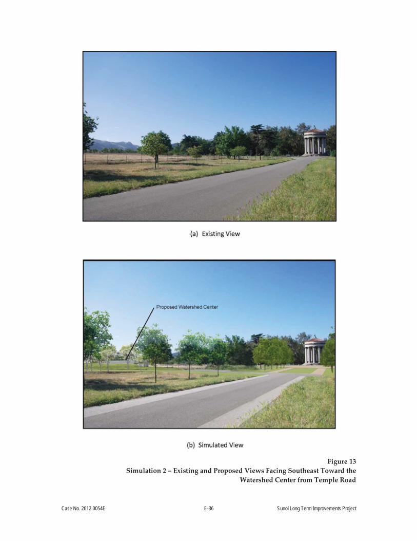
Case No. 2012.0054E E-36 Sunol Long Term Improvements Project
Figure 13
Simulation 2 – Existing and Proposed Views Facing Southeast Toward the Watershed Center from Temple Road

Case No. 2012.0054E E-37 Sunol Long Term Improvements Project
No direct view or simulation of the Sunol Yard was prepared because it is not highly visible from
public viewing locations toward the Temple. The Sunol Yard would be redeveloped with new
structures, and reconfigured to improve efficiency of operations. As a result of this
redevelopment, the project has the potential to alter the existing visual character and quality of
this portion of the site.
Review of the Sunol Yard Improvements, Civic Design Review Phase 1 document suggests that
the Sunol Yard has been designed to fit with the existing scale and character of its setting. The site
plan states that the Sunol Yard “intends to account for the geometry of the Sunol Water Temple
and the agricultural lines of the adjacent historic farmlands/orchards.29 The Sunol Yard
improvements incorporate formal patterns of linear landscaped corridors, which are intended to
create an organized rhythm that blends with the classical design of the Temple and the rural
character of the Sunol Valley.”30 Because of this, the improvements to the Sunol Yard are
anticipated to create a sense of order at the site. This will improve the overall visual quality of
this area, though it will remain screened from public viewing locations.
Based on the above findings, the project would have Less-than-Significant Impacts to existing
measures of visual quality and character of the site and its surroundings. This significance
determination is also based, in part, upon the analysis presented above, for Impacts AE-1 and
AE-2.
Impact AE-4: The project would not create a new source of substantial light or glare that would adversely affect day or nighttime views in the area, or that would substantially impact other people or properties. (Less than Significant)
Construction-period activities are not expected to require lighting, because construction would
occur primarily during daylight hours. Portable temporary lighting may be used during the
course of construction, given the proposed hours of construction (see Section A.5.7, Construction
Workforce and Construction Hours above), but this analysis assumes that it would be directed
downward to minimize light trespass to adjacent areas (as proposed), and would be temporary in
nature. Therefore, construction-period impacts from lighting would be Less than Significant.
29 SFPUC, 2013. Sunol Yard Improvements: Civic Design Phase 1. April 15. 30 Ibid.

Case No. 2012.0054E E-38 Sunol Long Term Improvements Project
Currently, the site of the proposed Watershed Center is not lit during evening hours. The Sunol
Yard is lit with safety and security lighting. Long-term operation of proposed structures in the
Sunol Yard and the Watershed Center would require installation of interior and exterior lighting
(see Section A.4.3, Lighting above).
The Watershed Center would be open to the general public between 9:00 a.m. and 3:00 p.m. and
for occasional evening events, so nighttime lighting at this facility would be predominantly for
safety and security purposes. According to Section A.4.3, Lighting (above), all proposed lighting
systems would be designed to minimize light trespass to neighboring properties, and would
meet State of California Title 24 Energy Efficiency requirements. Furthermore, the lighting
designs for outdoor facilities would be based on the building mounted cutoff luminaires to
minimize glare and light pollution in adjacent areas.31 Therefore, the project would not create a
new source of substantial light or glare that could adversely affect day or nighttime views in the
area, or that would be substantially visible to other people or properties. As a result, impacts
from lighting and glare at the Watershed Center and Sunol Yard would be Less than Significant.
Impact C-AE: The proposed project, in combination with past, present, and reasonably foreseeable future projects in the vicinity, would not have a significant cumulative effect on aesthetics. (No Impact)
The geographic scope for cumulative aesthetics impacts includes all projects that would be
located within the publicly accessible viewshed of the proposed project. The cumulative project
sites do not necessarily need to be visible simultaneously with the proposed project site from one
fixed vantage point; however, for an impact to occur the sites must be visible in the same general
vicinity by a viewer. Many projects listed in Table 9 are within the geographic scope for
cumulative impacts, but there are three projects located within the publically accessible viewshed
of the proposed project. Projects that could have a cumulative aesthetic impact in combination
with the proposed project are the Town of Sunol Fire Suppression Project, the SMP-32 Quarry
Operations, and the Alameda County Fire Department Sunol Project.
There are no publically accessible vantage points, including Thermalito Trail, from which the
cumulative projects and the proposed project can be viewed in the same general vicinity.
31 SFPUC, 2012. Sunol Master Plan Conceptual Engineering Report, Planning Phase III. Project No. CUW 2630601. Prepared by EMB/DPW-BD&C. April.

Case No. 2012.0054E E-39 Sunol Long Term Improvements Project
Therefore, there is no significant cumulative aesthetics impact to which both the proposed project
and other projects would contribute (No Impact).
Topics:
Potentially Significant
Impact
Less than Significant
with Mitigation
Incorporated
Less-than-Significant
Impact No
Impact Not
Applicable
E.3 POPULATION AND HOUSING— Would the project:
a) Induce substantial population growth in an area, either directly (for example, by proposing new homes and businesses) or indirectly (for example, through extension of roads or other infrastructure)?
b) Displace substantial numbers of existing housing units or create demand for additional housing, necessitating the construction of replacement housing elsewhere?
c) Displace substantial numbers of people, necessitating the construction of replacement housing elsewhere?
The project would improve the Sunol Yard, existing picnic area facilities, fencing, and Temple
Road, and construct a new Watershed Center. The project would have no effect on the
geographic extent or capacity of its existing water supply system, and therefore would not induce
population growth. Additionally, the project would not displace substantial numbers of existing
housing units or people, and would not require the construction of replacement housing.
The construction workforce would be small and would not require additional housing
accommodations, and operation and maintenance of the project would increase the workforce by
approximately 14 workers. However, this increase in workers would not substantially induce
population growth in the area, and is not anticipated to require the construction of housing for these
workers. For these reasons, the CEQA criteria related to population and housing are considered
not applicable to the project.
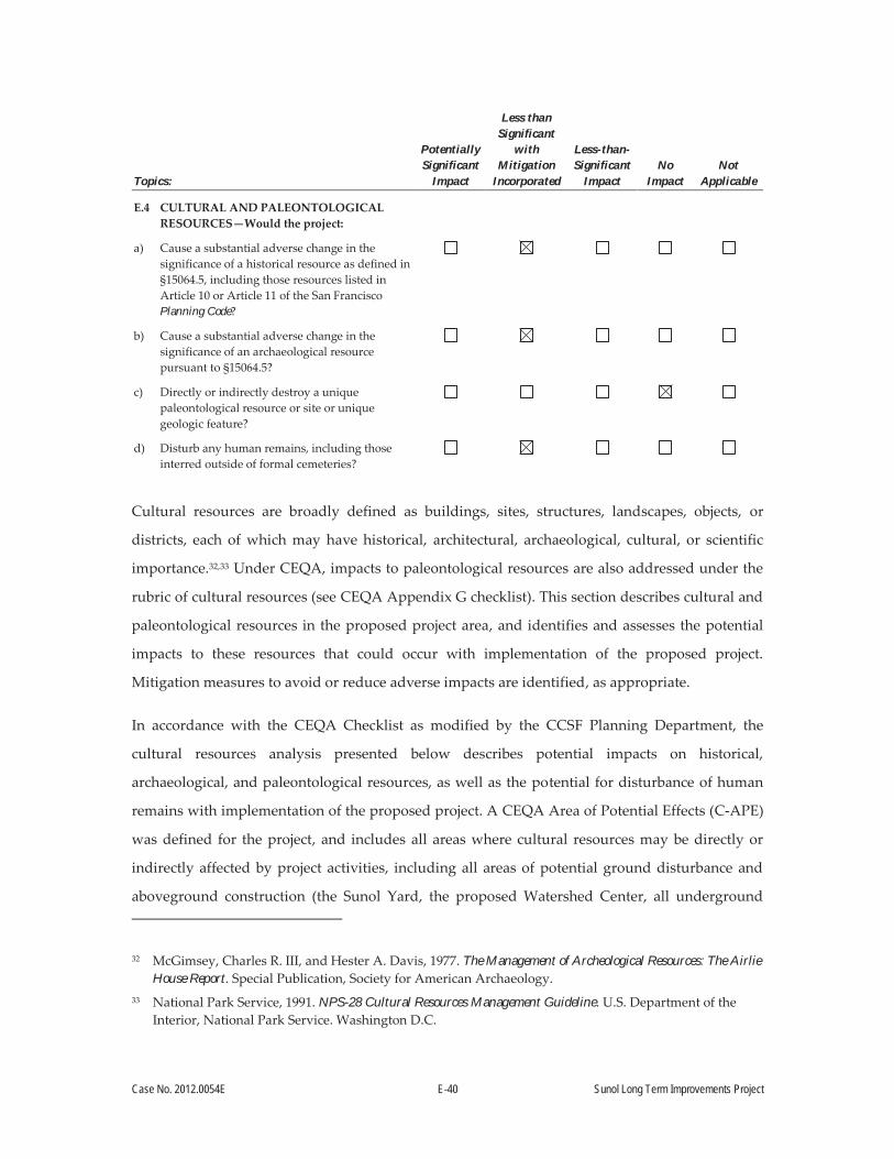
Case No. 2012.0054E E-40 Sunol Long Term Improvements Project
Topics:
Potentially Significant
Impact
Less than Significant
with Mitigation
Incorporated
Less-than-Significant
Impact No
Impact Not
Applicable
E.4 CULTURAL AND PALEONTOLOGICAL RESOURCES—Would the project:
a) Cause a substantial adverse change in the significance of a historical resource as defined in §15064.5, including those resources listed in Article 10 or Article 11 of the San Francisco Planning Code?
b) Cause a substantial adverse change in the significance of an archaeological resource pursuant to §15064.5?
c) Directly or indirectly destroy a unique paleontological resource or site or unique geologic feature?
d) Disturb any human remains, including those interred outside of formal cemeteries?
Cultural resources are broadly defined as buildings, sites, structures, landscapes, objects, or
districts, each of which may have historical, architectural, archaeological, cultural, or scientific
importance.32,33 Under CEQA, impacts to paleontological resources are also addressed under the
rubric of cultural resources (see CEQA Appendix G checklist). This section describes cultural and
paleontological resources in the proposed project area, and identifies and assesses the potential
impacts to these resources that could occur with implementation of the proposed project.
Mitigation measures to avoid or reduce adverse impacts are identified, as appropriate.
In accordance with the CEQA Checklist as modified by the CCSF Planning Department, the
cultural resources analysis presented below describes potential impacts on historical,
archaeological, and paleontological resources, as well as the potential for disturbance of human
remains with implementation of the proposed project. A CEQA Area of Potential Effects (C-APE)
was defined for the project, and includes all areas where cultural resources may be directly or
indirectly affected by project activities, including all areas of potential ground disturbance and
aboveground construction (the Sunol Yard, the proposed Watershed Center, all underground
32 McGimsey, Charles R. III, and Hester A. Davis, 1977. The Management of Archeological Resources: The Airlie House Report. Special Publication, Society for American Archaeology.
33 National Park Service, 1991. NPS-28 Cultural Resources Management Guideline. U.S. Department of the Interior, National Park Service. Washington D.C.

Case No. 2012.0054E E-41 Sunol Long Term Improvements Project
utilities, new parking areas, staging areas, etc.). The C-APE is equivalent to the project limit of
work as depicted on Figure 2. Baseline conditions for historic architectural resources and
archaeological resources, including those known to contain human remains, in the proposed
project C-APE are presented in technical reports produced prior to or specifically for the
proposed project.34,35,36,37,38
These studies assessed the potential eligibility of resources in the C-APE as historical resources,
based on criteria for listing in the CRHR. To be eligible for the CRHR, a resource must be
significant at the local, state, and/or federal level under one or more of the following criteria:
Is associated with events that have made a significant contribution to the broad patterns
of California’s history and cultural heritage;
Is associated with the lives of persons important in our past;
Embodies the distinctive characteristics of a type, period, region, or method of
construction, or represents the work of an important creative individual, or possesses
high artistic values; or
Has yielded, or may be likely to yield, information important in prehistory or history
(California Public Resources Code [PRC] Section 5024.1[c]).
For a resource to be eligible for the CRHR, it must also retain enough integrity to be recognizable
as a historical resource and to convey its significance. Resources listed in or formally determined
eligible for listing in the NRHP are listed in the CRHR.
34 JRP, 2003. Historic Resources Inventory and Evaluation Spring Valley Water Company’s Alameda Creek System. Prepared for the City and County of San Francisco.
35 JRP, 2008. Analysis of Historic Districts Potentially Impacted by San Francisco Public Utilities Commission Water System Improvement Program Projects. Prepared for San Francisco Public Utilities Commission, Bureau of Environmental Management, and City and County of San Francisco.
36 JRP, 2012. Final Historic Resources Inventory and Evaluation Report: Sunol Division Headquarters Complex and Sunol Water Temple Update, Sunol, California. Prepared for the City and County of San Francisco Public Utilities Commission.
37 URS, 2014. Final Historic Context and Archaeological Survey Report, an Archaeological Survey of the Sunol Long Term Improvements Project Area, Alameda County, California. Prepared for San Francisco Public Utilities Commission and San Francisco Planning Department, Environmental Planning Division.
38 URS, 2014. Sunol Water Temple, DPR 523 Update Sheet. Prepared for the San Francisco Public Utilities Commission.

Case No. 2012.0054E E-42 Sunol Long Term Improvements Project
This section summarizes the findings from these studies as they pertain to the historical resources
in the C-APE. It includes findings of the evaluation of the significance of historical resources in
the C-APE under the NRHP and CRHR criteria, discussions of resource historic integrity, and
evaluates project impacts in accordance with the CEQA Guidelines and the Secretary of the
Interior’s Standards for the Treatment of Historic Properties with Guidelines for Preserving,
Rehabilitating, Restoring, and Reconstructing Historic Buildings (Standards) (CEQA
Section 15064.5[b]).
The paleontological analysis is based on a records search completed at the University of
California Museum of Paleontology, in concert with a geological assessment as presented in the
archaeological technical report.39 Article 10 and Article 11 of the San Francisco Planning Code
pertain to individual city landmarks and historic districts, and to conservation districts in the city’s
downtown core area (C-3 district), respectively. Article 10 of the San Francisco Planning Code sets
forth proposals for city landmark designations with the aid of the NRHP Criteria in evaluating a
resource’s historic significance. Article 11, Section 1102 of the San Francisco Planning Code, codifies
the criteria for evaluating buildings in the C-3 districts of the city. Because the project does not
propose improvements in C-3 districts, and because there are no designated city landmarks or
districts in the proposed project area, Articles 10 and 11 of the San Francisco Historic
Preservation Commission and Planning Code would not apply.
Impact CP-1: The project could cause a substantial adverse change in the significance of a historical resource as defined in CEQA Guidelines Section 15064.5, including those resources listed in Article 10 or Article 11 of the San Francisco Planning Code. (Less than Significant with Mitigation Incorporated)
Approach
Under CEQA, a “historical resource” includes, but is not limited to, any object, building,
structure, site, area, place, record, or manuscript that is historically significant in the architectural,
engineering, scientific, economic, agricultural, educational, social, political, military, or cultural
annals of California. In addition, archaeological resources may be eligible to the CRHR as
“unique archaeological resources.” Effects to archaeological resources, both as historical
39 URS, 2014. Final Historic Context and Archaeological Survey Report, an Archaeological Survey of the Sunol Long Term Improvements Project Area, Alameda County, California. Prepared for San Francisco Public Utilities Commission and San Francisco Planning Department, Environmental Planning Division.
Case No. 2012.0054E E-43 Sunol Long Term Improvements Project
resources and unique archaeological resources, are dealt with under Impact CP-2. The following
discussion concerns impacts to historical resources of a non-archaeological nature.
Architectural surveys and evaluation reports, performed in 2003, 2008, and 2012 by JRP Historical
Consulting, LLC (JRP), that included the Sunol Water Temple and the Alameda Creek Water
Conveyance System District (ACWCSD), were reviewed by the preparers of this IS; and existing
conditions were verified on June 22, 2012, by URS Corporation (URS) architectural history staff
on behalf of the San Francisco Planning Department.40 Guidance from the California Office of
Historic Preservation notes that if there are not any substantive changes to the condition of the
subject property, and the original determinations remain valid, an additional architectural survey
is not necessary. After a review of the prior documents, and on behalf of the San Francisco
Planning Department, URS prepared a California Department of Parks and Recreation (DPR)
Form 523 Update Sheet to clarify the associated historic features of the Sunol Water Temple
property; provide additional information concerning the associations of the overall landscape
design with respect architect Willis Polk; and assess the integrity of the historic designed
landscape.41
Historic Architectural Resources in the C-APE
The results of the records review and field reconnaissance indicate that the C-APE includes
contributors to the NRHP/CRHR-eligible ACWCSD, as well as the NRHP/CRHR-eligible Sunol
Water Temple. The ACWCSD was recommended as eligible under NRHP/CRHR Criterion A/1
“as an important and early development in the context of the urban water supply in California,”
and eligible under Criterion C/3 for its “design and its innovative use of engineering to utilize the
natural features, mainly the gravel beds of the Alameda Creek.”42 Constructed by the Spring
Valley Water Company between 1887 and 1930, the ACWCSD is significant “as one of a few early
water conveyance systems designed specifically to meet the needs of a large urban population,”
and is “a significant work of engineering because it represents distinctive characteristics of a type,
40 JRP, 2012. Final Historic Resources Inventory and Evaluation Report: Sunol Division Headquarters Complex and Sunol Water Temple Update, Sunol, California. Prepared for the City and County of San Francisco Public Utilities Commission.
41 URS, 2014. Sunol Water Temple, DPR 523 Update Sheet. Prepared for the San Francisco Public Utilities Commission.
42 JRP, 2003. Historic Resources Inventory and Evaluation Spring Valley Water Company’s Alameda Creek System. Prepared for the City and County of San Francisco.

Case No. 2012.0054E E-44 Sunol Long Term Improvements Project
period, and method of construction.”43 NRHP/CRHR Criterion D/4 does not apply to the
ACWCSD, because this criterion applies to properties that contain or are likely to contain
information bearing on an important archaeological research question. Contributors to the
ACWCSD that are in the C-APE include the Sunol Water Temple and the Sunol Valley Filter Beds
(the latter is also referred to as the Filter Gallery).44 Contributors that are outside the C-APE
include the Sunol Aqueduct and Niles Regulating Reservoir.45 Two additional contributors, the
Niles and Sunol dams, were demolished in 2006.46 The Alameda Creek Water System was
designated in 1976 as a California Historic Civil Engineering Landmark by the San Francisco
section of the American Society of Civil Engineers.
In historic resource evaluations completed in 2003 and again in 2012, the Sunol Water Temple
and its associated historic features, including the remaining section of a Carrefour on the south
side of the intersection of Pleasanton-Sunol Road and Niles Canyon Road-Paloma Way,47 were
recommended as individually eligible for the NRHP/CRHR under Criterion C/3 for “its
architecture and as a work of master architect Willis Polk.”48,49 The evaluation reports note that
although the Sunol Water Temple was a relatively simple architectural commission, it was
“representative of Polk’s versatility as a designer and commitment to the principles of academic
eclecticism.”50,51 Design “simplicity, dignity, and refinement were fundamental values for Polk,”
43 JRP, 2003. Historic Resources Inventory and Evaluation Spring Valley Water Company’s Alameda Creek System. Prepared for the City and County of San Francisco.
44 Ibid. 45 Ibid. 46 SFPUC, 2006. Sunol/Niles Dam Removal Project Final Environmental Impact Report. Planning Department
Case No. 2001.1149E. Prepared by ESA. 47 A Carrefour is a term in classical architecture that refers to an open space from which a number of streets
or avenues radiate. See Harris, Cyril M. 1977. Illustrated Dictionary of Historic Architecture. New York: Dover Publications, Inc. The remaining portion of the Carrefour is also referred to in this document as the main gate.
48 JRP, 2003. Historic Resources Inventory and Evaluation Spring Valley Water Company’s Alameda Creek System. Prepared for the City and County of San Francisco.
49 JRP, 2012. Final Historic Resources Inventory and Evaluation Report: Sunol Division Headquarters Complex and Sunol Water Temple Update, Sunol, California. Prepared for the City and County of San Francisco Public Utilities Commission.
50 JRP, 2003. Historic Resources Inventory and Evaluation Spring Valley Water Company’s Alameda Creek System. Prepared for the City and County of San Francisco.

Case No. 2012.0054E E-45 Sunol Long Term Improvements Project
and were reflected in the Sunol Water Temple.52,53 The 2003 and 2012 evaluations do not include
the Temple Road/allée as a separate feature of the Sunol Water Temple, but it is briefly
mentioned as a feature of the Sunol Water Temple in the Analysis of Historic Districts Potentially
Impacted by San Francisco Public Utilities Commission Water System Improvement Program Projects.54
Additional archival research by the SFPUC (and reported by URS in a 2014 DPR Form 523
Update Sheet), revealed that in addition to the Sunol Water Temple and Carrefour, the Temple
Road was an integral feature within an intentionally designed landscape completed by architect
Willis Polk.55 The Sunol Valley Filter Beds, constructed c. 1900, were not designed by Polk, but
the architect positioned the Water Temple adjacent to the beds to integrate them into his overall
design scheme. The 2014 DPR Form 523 Update Sheet noted that the designed landscape was an
integral part of the larger property’s significance under NRHP/CRHR Criteria A/1 and C/3.
The Sunol Water Temple was recommended as not eligible under NRHP/CRHR Criterion B/2
because it “does not appear that this temple is associated with any people that have made
significant contributions to local, state, or national history.”56,57 It was also recommended as not
eligible under NRHP/CRHR Criterion D/4 because it is a well-documented resource that is not
51 JRP, 2012. Final Historic Resources Inventory and Evaluation Report: Sunol Division Headquarters Complex and Sunol Water Temple Update, Sunol, California. Prepared for the City and County of San Francisco Public Utilities Commission.
52 JRP, 2003. Historic Resources Inventory and Evaluation Spring Valley Water Company’s Alameda Creek System. Prepared for the City and County of San Francisco.
53 JRP, 2012. Final Historic Resources Inventory and Evaluation Report: Sunol Division Headquarters Complex and Sunol Water Temple Update, Sunol, California. Prepared for the City and County of San Francisco Public Utilities Commission.
54 SFPUC, 2008. Analysis of Historic Districts Potentially Impacted by San Francisco Public Utilities Commission Water System Improvement Program Projects.
55 URS, 2014. Sunol Water Temple, DPR 523 Update Sheet. Prepared for the San Francisco Public Utilities Commission.
56 JRP, 2003. Historic Resources Inventory and Evaluation Spring Valley Water Company’s Alameda Creek System. Prepared for the City and County of San Francisco.
57 JRP, 2012. Final Historic Resources Inventory and Evaluation Report: Sunol Division Headquarters Complex and Sunol Water Temple Update, Sunol, California. Prepared for the City and County of San Francisco Public Utilities Commission.

Case No. 2012.0054E E-46 Sunol Long Term Improvements Project
likely to contain information bearing on an important historical or archaeological research
question. The Sunol Water Temple area also includes a modern pump station, temporary
restrooms, farming operations, and non-functioning restroom facilities near the picnic area that
do not contribute to the historical resource’s significance.
The JRP evaluations of 2003 and 2012 confirmed that the Sunol Division Headquarters (now
known as the Sunol Corporation Yard) lacked sufficient integrity to be considered a historical
resource under CEQA. The Sunol Cottage in the Sunol Division Headquarters was also found to
individually lack sufficient integrity in 2007, a finding confirmed in 2012.58,59
Contributing and Non-Contributing Features. The features constructed on the Sunol Water
Temple property during its period of significance (1910) and that contribute to its significance
under NRHP/CRHR Criteria A/1 and C/3 were previously identified.60,61,62,63 These contributing
features are the Sunol Water Temple structure, its formal Carrefour at the intersection of
Pleasanton-Sunol Road and Niles Canyon Road-Paloma Way, the Temple Road/allée that leads
from the Carrefour to the Sunol Water Temple, and the Sunol Valley Filter Beds to the east of the
Sunol Water Temple. All of these features are axially aligned with one another, with the Temple
serving as the visual focal point.64,65
58 William Self and Associates, 2007. SFPUC Sunol Water Temple, Former Supervisor’s Dwelling. State of California, Department of Parks and Recreation, Primary Record and Building, Structure, and Object Record, California Historical Resource Information System, Northwest Information Center, Sonoma State University, Rohnert Park, California.
59 JRP, 2012. Final Historic Resources Inventory and Evaluation Report: Sunol Division Headquarters Complex and Sunol Water Temple Update, Sunol, California. Prepared for the City and County of San Francisco Public Utilities Commission.
60 JRP, 2003. Historic Resources Inventory and Evaluation Spring Valley Water Company’s Alameda Creek System. Prepared for the City and County of San Francisco.
61 JRP, 2008. Analysis of Historic Districts Potentially Impacted by San Francisco Public Utilities Commission Water System Improvement Program Projects. Prepared for San Francisco Public Utilities Commission, Bureau of Environmental Management, and City and County of San Francisco.
62 JRP, 2012. Final Historic Resources Inventory and Evaluation Report Sunol Division Headquarters Complex and Sunol Water Temple Update, Sunol, California. Prepared for the City and County of San Francisco Public Utilities Commission.
63 URS, 2014. Sunol Water Temple, DPR 523 Update Sheet. Prepared for the San Francisco Public Utilities Commission.
64 JRP, 2003. Historic Resources Inventory and Evaluation Spring Valley Water Company’s Alameda Creek System. Prepared for the City and County of San Francisco.

Case No. 2012.0054E E-47 Sunol Long Term Improvements Project
Integrity. Integrity is the ability of a property to convey its significance. The evaluation of
integrity is grounded in an understanding of a property’s physical features during the period of
significance, and how they relate to its significance. Integrity has seven components or aspects—
location, design, materials, workmanship, setting, feeling, and association. As discussed above,
for a property/resource to be eligible for the NRHP/CRHR, it must also retain enough integrity to
be recognizable as a historical resource, and to convey its significance.
In a 2012 report, JRP noted that the Sunol Water Temple “retains all of its integrity. The location
has not changed, the design remains the same, the setting has not changed drastically, the
Temple was restored in 2000 using the same materials, the workmanship remains the same as
Willis Polk had envisioned 100 years prior. It also retains integrity of feeling and association with
Willis Polk.”66 One modification to the Sunol Water Temple that has occurred since 2002 is the
installation of a wheelchair lift on the west side of the building.67 Character-defining features of
the Temple include its position adjacent to the Sunol Valley Filter Beds, its axial relationships
with the Carrefour, Temple Road, and Filter Beds, its round shape, as well as its overall classical
design.
The integrity of the Carrefour has been affected by the elimination of half of the resource’s former
circular arrangement at the intersection of Pleasanton-Sunol Road and Niles Canyon Road-
Paloma Way. To bring the intersection up to more modern safety standards, the northern half of
the Carrefour was removed, while the southern half (the half with the entrance gate to the Sunol
Water Temple) was retained. Even with the removal of half of the Carrefour, the element remains
significant feature of the larger Sunol Water Temple property.68 The character defining elements
65 URS, 2014. Sunol Water Temple, DPR 523 Update Sheet. Prepared for the San Francisco Public Utilities Commission.
66 JRP, 2012. Final Historic Resources Inventory and Evaluation Report Sunol Division Headquarters Complex and Sunol Water Temple Update, Sunol, California. Prepared for the City and County of San Francisco Public Utilities Commission.
67 Ibid. 68 JRP, 2003. Historic Resources Inventory and Evaluation Spring Valley Water Company’s Alameda Creek System.
Prepared for the City and County of San Francisco.

Case No. 2012.0054E E-48 Sunol Long Term Improvements Project
of the Carrefour include its semi-circular plan, classical detailing, reliefs, and its axial relationship
with Temple Road and the Water Temple.
The Temple Road/allée has been altered since its construction in 1910. Historic photographs and
original site plans show that the road surface was originally bladed dirt or gravel. These
photographs, in addition to the 1910 site plans, reveal that the road was edged with a continuous,
low-lying hedge, and exhibited two rows of small trees.69 This high density landscape
arrangement was replaced over time by the SFPUC; the current configuration is two rows of trees
with a spacing distance that appears to be slightly greater than the original pattern. Currently, the
road consists of an asphalt surface and is approximately 18 feet wide. Despite these modifications
over time, the Sunol Water Temple, its associated features, and its designed landscape retain
sufficient integrity of location, feeling, association, materials, workmanship, setting, and design
to be individually eligible for the NRHP/CRHR, and therefore a historical resource under CEQA.
Character defining features of the Temple Road include its linear alignment and its axial
relationship with the Water Temple and the Carrefour.
Although the integrity of the Sunol Valley Filter Beds is not specifically discussed in the
evaluation of the ACWCSD, the field reconnaissance of the site did not reveal any substantive
changes to the resource since its evaluation in 2003, and the Sunol Valley Filter Beds, although
predating the Water Temple, were clearly integrated into Polk’s landscape design.70 As a
contributor to the ACWCSD and as an associated feature of the individually eligible Sunol Water
Temple’s designed landscape, the Sunol Valley Filter Beds are eligible for the NRHP/CRHR, and
are therefore a historical resource under CEQA. Character-defining features of the Filter Beds
(that are visible at the surface) include their depressed profile and grassy beds. The Filter Bed to
the southeast of the Water Temple also includes a concrete walkway and remnants of a concrete
pad that formerly held a low balustrade surround.
69 URS, 2014. Sunol Water Temple, DPR 523 Update Sheet. Prepared for the San Francisco Public Utilities Commission.
70 JRP, 2003. Historic Resources Inventory and Evaluation Spring Valley Water Company’s Alameda Creek System. Prepared for the City and County of San Francisco.

Case No. 2012.0054E E-49 Sunol Long Term Improvements Project
Project Effects
As described above, the Sunol Water Temple and its associated features are an eligible historical
resource. These structures are also contributors to the ACWCSD, which is also an eligible
historical resource. Contributing features of these historical resources would be affected by the
project: the Sunol Water Temple, the Sunol Valley Filter Beds, the Carrefour, and Temple Road.
These features are part of a larger historic designed landscape that contributes to the significance
of the Sunol Water Temple property. This analysis evaluates the impact of project
implementation on historical resources in accordance with CEQA Guidelines Section 15064.5(b),
which defines a substantial adverse change in the significance of a historical resource as follows:
Physical demolition, destruction, relocation, or alteration of the resource or its
immediate surroundings such that the significance of an historical resource
would be materially impaired. Material impairment is further defined as
demolishing or materially altering in an adverse manner those physical
characteristics of an historical resource that convey its historical significance and
that justify its inclusion in, or eligibility for, inclusion in the CRHR or a local
register of historical resources.
As noted in CEQA Section 15064.5(b)(3), a project that follows the Standards shall be considered
to be mitigated to a less-than-significant level. Of the four treatment options offered by the
Standards, the one that would apply to the proposed project would be Rehabilitation, which is
defined as “the act or process of making possible a compatible use for a property through repair,
alterations, and additions while preserving those portions or features which convey its historical,
cultural, or architectural values,” generally referred to as the Secretary of the Interior’s Standards for
Rehabilitation (Standards for Rehabilitation).
The Standards for Rehabilitation require that the historic character of a property be retained and
preserved, and that the removal of distinctive materials or alteration of features, spaces, and
spatial relationships that characterize a property be avoided. Repair is emphasized over
replacement. Replacement of historic features is allowable under the Standards; however, the new
features should match the old in design, color, texture, and where possible, materials. The
Standards recognize situations where replacement in-kind is not technically, economically, or
environmentally feasible. In such situations, compatible substitute materials that have similar
characteristics can be considered.

Case No. 2012.0054E E-50 Sunol Long Term Improvements Project
Project components that would comply with the Standards include the removal of non-historic
features from the area immediately near the Sunol Water Temple, which include a restroom
building, temporary restroom facilities, barbed-wire fencing to the south of the Sunol Water
Temple near the picnic area, a concrete construction staging pad used for the 2000 restoration of
the temple, and an informal gravel parking area for 15 vehicles. The removal of these elements
would clarify the historic visual relationships between the Sunol Water Temple and associated
features.
The Temple Road would be repaved, and shoulders made of resin pavement or like material
would be installed. The paved surface of the Temple Road does not date from the period of
significance, and the addition of the shoulders would modify the width of the Temple Road/allée
to accommodate pedestrians. The addition of the shoulders would make the Temple Road/allée
surface appear wider than its historic appearance, but the surface would be of a compatible
material, likely similar to the compacted dirt/gravel material used for the original Temple Road.
Landscape vegetation that has flanked the road over time has changed and evolved with the
management of the site. The existing grass ground cover was not present during the period of
significance. As a result, impacts from the repaving and installation of shoulders to Temple Road
would be Less than Significant as the Temple Road would retain its character defining features,
most notably its axial relationship with the Water Temple.
As a part of the Watershed Center, the setting of the Sunol Water Temple and its associated
features would be modified by the construction of the one-story Watershed Center, access road,
and parking spaces for approximately 35 cars and three buses. A rectilinear circulation pattern of
walkways around the Center is designed to be consistent and compatible with the formal nature
of the Sunol Water Temple and associated features. The proposed placement of the modern
building to the northeast of the Sunol Water Temple has the potential to impact the setting of the
Sunol Water Temple and the Sunol Valley Filter Beds. However, the proposed location of the
Watershed Center is sensitively sited to the southeast so as not to fragment or obscure the axial
relationships between the Sunol Water Temple and its associated features. The Center’s location
would ensure that the visual relationships between the associated features would remain intact.
The conceptual plan also includes retaining existing vegetation, and planting new trees between
the two buildings to reduce the visibility of the building from the Sunol Water Temple and the
Sunol Valley Filter Beds (see Figures 5 and 13). In addition, simulations indicate that the new
buildings proposed in the Sunol Yard would not visually intrude into the linear arrangement of

Case No. 2012.0054E E-51 Sunol Long Term Improvements Project
trees along the allée/avenue between the Sunol Water Temple and the Carrefour (see Figure 12).
As a result, these project elements would result in impacts on historical resources that are Less
than Significant because they would not materially impair the character-defining features of the
Water Temple and its associated features – most notably the axial relationships between the
Temple, Temple Road, Carrefour, and Filter Beds.
The Sunol Valley Filter Beds would remain in place south of the proposed Watershed Center; and
the proposed changes to the setting caused by the construction of the Watershed Center and the
landscape modifications near the Sunol Water Temple would be minimally visible from the Sunol
Valley Filter Beds because the Filter Beds are not open to public access and lie several feet below
the proposed site of the Watershed Center. For these reasons, no project elements, including
proposed fencing around the Sunol Valley Filter Beds, would fragment or obstruct the axial
relationship between the Sunol Valley Filter Beds and the Sunol Water Temple. No direct or
indirect impacts from project construction are anticipated. Therefore, project impacts to the Sunol
Valley Filter Beds would be Less than Significant.
The proposed forecourt would replace the current pavement immediately north of the Water
Temple. The forecourt would consist of a central grass panel flanked by walkways composed of
resin pavement or like material. The Temple Road would terminate at the forecourt; an access
road to the east would approach the Watershed Center. A paved, short term parking area would
also be added to the east of Temple Road. The parking area would be obscured by new
vegetation from the Water Temple, Temple Road/allee, and Carrefour. Designed to the
approximate width of Temple Road, the grass panel would be flanked to the east and west by
trees that approximate the alignment and height of the existing trees on the sides of Temple
Road. The existing trees along the Temple Road/allée are not original to the period of
significance for the Sunol Water Temple, but their current height appears similar to the height of
vegetation depicted in historic period photographs and plans (Appendix A). As a result, impacts
from the forecourt design would be Less than Significant as the forecourt would be compatible
with the historic design of the Water Temple property and would not inhibit or obscure the axial
relationships between the Sunol Water Temple, Temple Road/allée, Carrefour, and Sunol Valley
Filter Beds.
There is a potential for significant adverse impacts to be caused by the operation of construction
equipment during construction of the Watershed Center. Damage caused by this equipment due
to operator accidents or use in close proximity to the Sunol Water Temple and its associated

Case No. 2012.0054E E-52 Sunol Long Term Improvements Project
features may diminish the integrity of historical resources. Situated at the entrance to the facility,
the Carrefour, for instance, has the potential to be impacted when construction vehicles enter and
exit the facility.
To minimize the potential for such significant impacts that could affect the historical resource’s
eligibility for listing through material impairment, the implementation of Mitigation
Measure M-CP-1a, Historic Resources Protection Plan, is required to reduce impacts to a level
that is Less than Significant with Mitigation Incorporated. This would be accomplished by preparing
and implementing a plan to educate workers, situate equipment storage yards away from
historical resources, and manage vehicle operations near historical resources, which would then
serve to reduce the potential for accidental damage of onsite historical resources. With
implementation of such a plan, and given the ample staging areas and access points to the
property, it would be feasible to avoid significant impacts to onsite historical resources.
As indicated in Table 13 in Section E.6, Noise, project-related construction activities are
estimated to generate vibration levels well below the 0.5 in/sec PPV and 0.3 in/sec PPV thresholds
for transient and continuous vibrations, respectively, to buildings, even if two pieces of
equipment were both operating 20 feet from a structure. Because both the Carrefour and the
Water Temple are more than thirty years old, the more conservative “older residential building”
category established by the Federal Transit Administration was used. In light of the above,
construction activities near these two buildings would not generate sufficient vibration to cause
impacts to either structure that would result in the material impairment of either resource, which
would result in a Less than Significant Impact.
Nevertheless, large construction equipment may generate vibration that could cause damage to
the historic fabric of the historical resource, thereby causing a significant impact. To avoid the
potential for significant impacts to historic resources, the implementation of Mitigation
Measure M-CP-1b, Preconstruction Surveys and Vibration Monitoring, is required to reduce
the potential for vibration-related impacts to a level that is Less than Significant with Mitigation
Incorporated. These required surveys and monitoring would reduce the potential for vibration
effects on historical resources by identifying potential sources of vibration, and undertaking
alternative construction methods with less vibratory potential.

Case No. 2012.0054E E-53 Sunol Long Term Improvements Project
Mitigation Measure M-CP-1a: Historic Resources Protection Plan
The SFPUC shall retain a qualified engineer, in coordination with a qualified historic
architect or architectural historian, to prepare a historic resources protection plan that
specifies actions and methods that the contractor will undertake to reduce the likelihood
of accidental collision damage to the Sunol Water Temple, Carrefour, and Sunol Valley
Filter Beds when construction equipment pass in proximity to these historical resources.
The plan shall require the Contractor to monitor activities to ensure use of protective
measures. At a minimum, the plan shall address: 1) guidelines for the operation of
construction equipment near the historical resources; 2) storage of construction materials
and equipment away from the resources, as appropriate; 3) pre- and post-construction
recording of the Sunol Water Temple, Carrefour, and the Sunol Valley Filter Beds to
confirm post-construction condition; 4) requirements for monitoring and documenting
compliance with the plan; and 5) use of exclusion fencing, and/or signs and education/
training of construction workers about the protection of the historical resources. The plan
shall be reviewed and approved by the SFPUC and implemented prior to use of project
construction equipment in these three areas. In case accidental damage occurs during the
construction of the project, the plan shall also direct the Contractor to stop the work
activity that caused the damage, propose interim protection measures, and develop
repair measures. The repair measures shall be reviewed and approved by the SFPUC
prior to Contractor implementation, and will be monitored by the SFPUC for compliance
with Secretary of the Interior’s Standards for Treatment of Historic Properties.
Mitigation Measure M-CP-1b: Preconstruction Surveys and Vibration Monitoring
Prior to construction, the SFPUC shall retain the services of a California-licensed
geotechnical engineer or similarly qualified expert in vibration effects on structures to
1) assess the potential for vibration effects on the Sunol Water Temple, Carrefour, and
Sunol Valley Filter Beds from construction activities; 2) identify pre-construction and
construction-period activities to be conducted by the contractor to monitor for and report
on potential vibration effects, including settlement and cracking; and 3) identify
measures to be undertaken by the contractor if vibration effects are identified during
monitoring, such as stopping adverse construction activities, contractor use of alternative
construction methods that reduce the potential for vibratory impacts, and reduced
vehicle speeds. The SFPUC shall also implement Mitigation Measure M-CP-1c,

Case No. 2012.0054E E-54 Sunol Long Term Improvements Project
Secretary of the Interior’s Standards for Treatment of Historic Properties, to repair
damage to onsite historical resources caused by the project.
As a part of the proposed Carrefour repair work, (see Section A.4.1, Sunol Corporation Yard
Improvements, above), the existing concrete pillars would be inspected and repaired, as
necessary. Repairs would retain existing architectural features. The existing wrought-iron fence
and gate would be cleaned and repainted, or where necessary, components of the fence would be
replaced. The existing modern gate opener and hardware would be upgraded to meet current
security standards.
There is a potential for this project component to result in repairs that may not be consistent with
the Standards, and therefore have a significant impact on the character-defining features of the
Carrefour. To avoid significant impacts caused by the proposed repair work to the Carrefour,
implementation of Mitigation Measure M-CP-1c, Secretary of the Interior’s Standards for
Treatment of Historic Properties, would be required to reduce impacts to a level that is Less than
Significant with Mitigation Incorporated, by developing a process by which the proposed work for
the Carrefour is reviewed by the Planning Department for consistency with the Standards.
Mitigation Measure M-CP-1c: Secretary of the Interior’s Standards for Treatment of Historic Properties
Details of the proposed repair work to the Carrefour, including but not limited to plans,
drawings, and photographs of existing conditions, shall be submitted by the SFPUC to
the San Francisco Planning Department prior to implementation. An architectural
historian that meets the Secretary of the Interior’s Professional Qualification Standards
within the Planning Department will review the proposed project for compliance with
the Standards. If necessary, the SFPUC shall pursue and implement a redesign of the
proposed repair work to the Carrefour to the extent feasible, so that consistency with the
Standards is achieved and/or a significant impact is avoided, as determined by the
Planning Department.

Case No. 2012.0054E E-55 Sunol Long Term Improvements Project
Impact CP-2: The project could cause a substantial adverse change in the significance of an archaeological resource pursuant to Section 15064.5. (Less than Significant with Mitigation Incorporated)
Approach
The following discussion assesses impacts to archaeological resources meeting the requirements
for listing as historical resources, as described above, as well as impacts to unique archaeological
resources as described in CEQA Guidelines Section 15064.5 and PRC Section 21083.2.71 If an
archaeological site does not meet the criteria for inclusion on the CRHR but does meet the
definition of a unique archaeological resource as outlined in PRC 21083.2, it is still entitled to
attention under CEQA.
As outlined in the Historic Context and Archaeological Survey Report (HCASR) for the project,
inventory efforts for archaeological resources included a review of ethnographic and historic
literature and maps, archaeological base maps and site records, survey reports, and atlases of
historic places on file at the Northwest Information Center (NWIC) of the California Historical
Resources Information System at Sonoma State University; Native American contacts; an
archaeological pedestrian reconnaissance survey; and extended subsurface archaeological
investigations in the vicinity of the proposed Watershed Center and the existing Sunol Cottage
(Figure 3, feature 5).72
The C-APE is within the boundaries of the Mexican-era Rancho Valle de San José land grant,
granted in 1839 by Governor Juan Alvarado to Antonio María Pico, Agustín Bernal, Juan Pablo
Bernal, and María Dolores Bernal de Suñol. A survey of Spanish- and Mexican-period adobe
buildings conducted in the early 20th century by Hendry and Bowman identifies an adobe
residence owned by the Suñol family as having existed previously in the C-APE.73 In 1862,
Charles Hadsell, a prominent farmer and rancher originally from Massachusetts, acquired
2,332 acres of the Valle de San José land grant, including what is now the project C-APE. Hadsell
71 Archaeological resources (or sites) are also referred to as “heritage sites” by some tribal members. 72 URS, 2014. Final Historic Context and Archaeological Survey Report, an Archaeological Survey of the Sunol Long
Term Improvements Project Area, Alameda County, California. Prepared for San Francisco Public Utilities Commission and San Francisco Planning Department, Environmental Planning Division.
73 Hendry, G.W., and J.N. Bowman, 1940. The Spanish and Mexican Adobe and Other Buildings in the Nine San Francisco Bay Counties, 1776 to about 1850. On file at the Bancroft Library, University of California Berkeley.

Case No. 2012.0054E E-56 Sunol Long Term Improvements Project
resided in and ran a dairy in the C-APE until he sold it to the Spring Valley Water Company in
approximately 1875. It is possible that archaeological remains of the adobe buildings and other
appurtenant structures, as well as the remains of other features such as corrals, gardens, and
hollow/filled features containing artifacts associated with the historic-period occupation, may still
exist in the C-APE.
Archaeological Resources in the C-APE
As a result of the inventory efforts, two archaeological sites have been identified in the C-APE.
One site, CA-ALA-565/H, contains primarily prehistoric archaeological material, features, and
fragmentary human remains, as well as limited historic-era artifacts.74,75,76 The site was originally
recorded in 1993, and subsequently subjected to subsurface archaeological testing. The
investigation identified three artifact concentrations in the site. Two of the areas had cultural
material dated to protohistoric occupation (A.D. 1500-1700). In the third area, projectile points
and bone tools were found, in addition to transfer-printed ceramics, possibly evincing a historic-
era occupation.77 The excavation recovered cultural materials to a depth of 51 inches bgs.78,79 The
southern and western boundaries of CA-ALA-565/H were reconfirmed in 2012 through
pedestrian surveys and a subsurface extended archaeological survey consisting of augers and
borings.80
During the 2012 field inventory efforts, a second archaeological resource was identified, and
designated as field recording number SYIP-1.81 This historic-era resource contains limited mid- to
74 Luby, Edward M., 1993. Archaeological Site Records for P-01-000015. On file at the NWIC. 75 Luby, Edward M., 1995. Preliminary Report on Archaeological Investigations in the Sunol Valley, Alameda
County, California. Proceedings of the Society for California Archaeology (8): 167-174. 76 URS, 2014. Final Historic Context and Archaeological Survey Report, an Archaeological Survey of the Sunol Long
Term Improvements Project Area, Alameda County, California. Prepared for San Francisco Public Utilities Commission and San Francisco Planning Department, Environmental Planning Division.
77 Luby, Edward M., 1995. Preliminary Report on Archaeological Investigations in the Sunol Valley, Alameda County, California. Proceedings of the Society for California Archaeology (8): 167-174.
78 Luby, Edward M., 1993. Archaeological Site Records for P-01-000015. On file at the NWIC. 79 Luby, Edward M., 1995. Preliminary Report on Archaeological Investigations in the Sunol Valley, Alameda
County, California. Proceedings of the Society for California Archaeology (8): 167-174. 80 URS, 2014. Final Historic Context and Archaeological Survey Report, an Archaeological Survey of the Sunol Long
Term Improvements Project Area, Alameda County, California. Prepared for San Francisco Public Utilities Commission and San Francisco Planning Department, Environmental Planning Division.
81 Ibid.

Case No. 2012.0054E E-57 Sunol Long Term Improvements Project
late-19th century artifacts in association with compacted earth features, which were identified
during inspection of the crawl space below the former Sunol Cottage and existing Administration
Building in the Sunol Yard. Temporally diagnostic artifacts and spatial information, gained from
historical descriptions and maps, indicate that elements of the archaeological deposit may be
associated with the Suñol Adobe or the Hadsell occupation.82
Based on substantial evidence, the San Francisco Planning Department has determined that SYIP-
1 and CA-ALA-565/H constitute historical resources pursuant to Section 15064.5(a)(3) of the
CEQA Guidelines. As the sites will be treated as historical resources, it is not necessary to
consider their status as unique archaeological resources in this analysis.
Although not all the characteristics of these archaeological sites are known, they are likely to
yield information important in prehistory or history, and therefore appear eligible to the CRHR
under Criterion 4. In addition, if historic-era associations with the early Suñol or Hadsell
occupation of the property are confirmed, both archaeological sites may be eligible to the CRHR
under Criterion 1, for their association with events that made a significant contribution to history
at the local or state level.
As currently proposed, construction of the Watershed Center would occur at least partially
within the confines of CA-ALA-565/H, and project demolition and construction in the Sunol Yard
would occur on SYIP-1. Excavation of new building foundations would be accomplished by
backhoe or excavator. The depth of the excavations would vary depending on facility height and
site conditions, but would generally not exceed 5 feet below the current ground surface, except at
the locations of the existing underground fuel storage tanks and existing and proposed
wastewater holding tanks, where excavation work may range to 15 feet below grade. Given these
subsurface impacts, implementation of the proposed project could result in a substantial adverse
change in the significance of a historical resource as defined in CEQA Guidelines Section 15064.5,
which would be a significant impact. However, implementation of Mitigation
Measure M-CP-2a, Treatment of Known Archaeological Resources, would reduce impacts to a
level that is Less than Significant with Mitigation Incorporated by requiring that resources are
properly identified and protected upon discovery, and that an archaeological research design and
treatment plan (ARDTP), as described below, is implemented.
82 Ibid.

Case No. 2012.0054E E-58 Sunol Long Term Improvements Project
In addition to the potential impacts to known resources, ground-disturbing construction
activities have the potential to inadvertently expose and therefore affect previously unknown
archaeological resources, including those that may be CRHR-eligible. As described in the
HCASR, subsurface testing using borings and backhoe scrapes was conducted in the southern
portion of the C-APE and in the vicinity of the Sunol Cottage.83 No archaeological resources were
identified as a result of these extended archaeological survey efforts; however, there is the
potential that previously unidentified archaeological resources may be exposed as a result of
project-related ground disturbance. The inadvertent exposure of previously unknown
archaeological resources that qualify as historical resource as addressed under CEQA Guidelines
Section 15064.5 would be a potentially significant impact. However, implementation of
Mitigation Measure M-CP-2b, Archaeological Monitoring and Accidental (Post-review)
Discovery of Archaeological Resources, would reduce impacts to a level that is Less than
Significant with Mitigation Incorporated by requiring an appropriate treatment strategy, such as
archaeological data recovery.
CEQA Section 21083.2.(b) provides that the lead agency may require reasonable efforts be made to
permit any or all of these resources to be preserved in-place (e.g., through “capping”84) or left in an
undisturbed state. Alternative treatments may be considered if preservation in place is not feasible,
or, if feasible, when a data recovery program or interpretive use of the resource provides superior
mitigation. As discussed in Section A.4.2, the SFPUC considered alternative locations and designs
for the Watershed Center in order to avoid impacting site CA-ALA-565/H, but did not identify any
as able to feasibly meet the Project’s goals, and found that all other alternative areas onsite could
themselves involve other environmental impacts. Having reviewed the record, the San Francisco
Planning Department agrees that locating the Watershed Center elsewhere onsite could result in
other potentially significant impacts (see Section A.4.2, Development of the Alameda Creek
Watershed Center). Capping CA-ALA-565/H is also not considered a viable alternative in this case
because placing the Watershed Center on a fill prism of sufficient height to keep the building
foundation, road bed, and subsurface utilities above the archaeological site matrix could cause
significant visual impacts on the viewshed of the adjacent Sunol Water Temple, which is part of an
83 Ibid. 84 Capping an archaeological site means to cover it with a layer of sterile soil before building directly on
top of the site in question.

Case No. 2012.0054E E-59 Sunol Long Term Improvements Project
eligible historic district and as discussed above, could result in contamination of the archaeological
site matrix by impurities in the imported fill and could damage site constituents (and, thereby, the
site’s research and cultural values) through compaction caused by construction activities and the
weight of the fill and building. Nevertheless, and as noted above, Mitigation Measure M-CP-2a,
Treatment of Known Archaeological Resources, would reduce impacts to this site to a level that is
Less than Significant with Mitigation Incorporated by requiring that archaeological resources are
properly identified and protected upon discovery, and that an archaeological research design and
treatment plan (ARDTP), as described below, is implemented.
In the case of archaeological site SYIP-1, further investigations, possibly leading to data recovery,
are considered the preferred mitigation. Very little is known of the historic-era Sunol and Hadsell
occupations of the project area. Historic documentation of these occupations is very limited and no
archaeological excavations have been conducted to-date which may provide information on this
time period. The characteristics of this site make it unsuitable for public interpretation in-place
(given that it is the administrative hub of the Sunol Corporation Yard, and as such, it is an area that
is not open to the general public). As a result, there exists greater value in extracting the potential
data within SYIP-1 than preserving the potential resource in-place.
Given these considerations, the following site-specific mitigation measures have been developed for
the treatment of known archaeological resources and to avoid potentially significant adverse effects
of the proposed project on legally important archaeological resources known to be within the
project area:
Mitigation Measure M-CP-2a: Treatment of Known Archaeological Resources
The SFPUC shall retain the services of a qualified archaeological consultant, meeting the
Secretary of Interior standards for archaeology, from the pool of qualified archaeological
consultants maintained by the Planning Department Archeologist, or an alternate
archaeological consultant on approval of the ERO. The archaeological consultant shall
develop and undertake any archaeological monitoring, testing, and mitigation programs
required in connection with this Mitigation Measure, the scope and implementation of
which shall be directed and approved by the ERO or designee.85
85 San Francisco Planning Department, 2008. MEA WSIP Projects Archaeological Guidance.

Case No. 2012.0054E E-60 Sunol Long Term Improvements Project
Archaeological site CA-ALA-565/H. In consultation with the ERO or designee, the
archaeological consultant shall design and carry out an archaeological testing program at
CA-ALA-565/H. The goal of the testing program shall be to provide an enhanced
delineation of the archaeological site’s structure and content in areas of planned
construction. The plan shall also detail the participation of Native American cultural
resource monitors during excavation and testing. The testing program shall be
documented to the ERO in a preapproved format.
On the basis of the testing results and in consultation with the ERO or designee, the
consultant shall prepare an Archaeological Research Design and Treatment Plan
(ARDTP) for the recovery and treatment of resources determined to be potentially
eligible to the California Register of Historical Resources (CRHR). The ARDTP shall
identify how data recovery and other treatments, such as development of interpretive
materials, will preserve the significant information of the archaeological resources to be
impacted by the project. That is, the ADRTP will identify what scientific/historical
research questions are applicable to the expected resource, what data classes the resource
is expected to possess, and how the expected data classes would address the applicable
research questions. The ADRTP will establish the procedures for data recovery and other
treatments, describe how the investigation will address the research issues, and specify
that the results will be provided in an Archaeological Data Recovery Report to the ERO
or designee following implementation of the ARDTP. In general, data recovery shall be
limited to the portions of the archaeological resource that could be adversely affected by
the proposed project. The ARDTP shall include the elements specified in EP’s
Archaeological Guidance #7, including goals of the plan, description of the resource,
research questions, field methods for recovering resources, laboratory methods, other
treatment options (i.e., interpretive programs), and details on Native American
coordination, as well as a practical work plan to carry out the program. The SFPUC shall
ensure that the provisions of the ARDTP are carried out.
Archaeological site SYIP-1. The archaeological consultant shall monitor and, as
necessary, direct the demolition of the Sunol Cottage and administration building to
better determine the vertical and horizontal extent, and potential significance, of the

Case No. 2012.0054E E-61 Sunol Long Term Improvements Project
cultural deposit SYIP-1.86 The buildings shall be deconstructed in a manner that
minimizes impacts to the deposit below the crawl space; for example, by first removing
all walls and roofs above the subfloor, then carefully deconstructing the subfloor. The
SFPUC shall ensure that archaeological resources uncovered during this process are
protected until the ERO or designee has determined appropriate treatment. The results of
this phase of work shall be documented to the ERO in a letter report.
In consultation with the archaeological consultant, the ERO or designee shall determine if
new discoveries made during fieldwork at SYIP-1 appear to constitute historical
resources. If the ERO determines that the newly discovered archaeological resources
constitute historical resources, the ERO may require treatment such as archaeological
data recovery or the creation of an interpretive product. Treatment, if required, shall be
presented in an ADRTP, as described above, prior to implementing data recovery. The
SFPUC shall ensure that the provisions of the ARDTP are carried out.
Plan approvals and distribution. All plans and reports prepared by the consultant
further to this Mitigation Measure shall be submitted first and directly to the ERO or
designee for review and comment, and shall be considered draft reports subject to
revision until final approval by the ERO. Once approved, copies of the reports shall be
distributed as follows: the California Historical Resources Information Center (NWIC)
shall receive one copy; the ERO shall receive a copy of the transmittal of the reports to the
NWIC. EP shall receive one bound, one unbound, and one unlocked, searchable PDF
copy on CD (of archival quality) as well as copies of any formal site recordation forms
(CA DPR 523 series), and/or documentation for nomination to the CRHR. In instances of
high public interest or interpretive value, the ERO may require a different final report
content, format, and distribution than that presented above.
86 URS, 2014. Final Historic Context and Archaeological Survey Report, an Archaeological Survey of the Sunol Long Term Improvements Project Area, Alameda County, California. Prepared for San Francisco Public Utilities Commission and San Francisco Planning Department, Environmental Planning Division.

Case No. 2012.0054E E-62 Sunol Long Term Improvements Project
Mitigation Measure M-CP-2b: Archaeological Monitoring and Accidental (Post-review) Discovery of Archaeological Resources
This Mitigation Measure is required to avoid and/or minimize potential adverse effects of
construction-related activities on previously unknown, accidentally discovered, and
potentially important resources by ensuring that they are recognized, protected, and
treated appropriately.
Monitoring Plan. The SFPUC shall retain the services of an archaeological consultant
meeting the Secretary of Interior standards for archaeology from the pool of qualified
archaeological consultants maintained by the Planning Department archaeologist or an
alternate archaeological consultant upon approval of the ERO. In consultation with the
ERO or designee, the consultant shall prepare an Archaeological Monitoring Plan (AMP)
in conformity to EP’s Archaeological Guidance that specifies how archaeological
monitoring shall be carried out on the project site, including monitoring locations,
authority of the archaeological monitor, reporting, and steps to be implemented in the
event of a discovery, including Native American coordination. The SFPUC shall ensure
that the terms of the AMP are carried out.
ALERT Sheet and Training. The SFPUC shall ensure, prior to any soils disturbing
activities, the distribution of the Planning Department’s archaeological resource
“ALERT” sheet to all personnel (including, machine operators, field crew, supervisory
personnel, etc.) of the project prime contractor, any project subcontractor and any utilities
firm involved in soils disturbing activities within the project site (including demolition,
excavation, grading, foundation work, etc.). The SFPUC shall provide the ERO with a
signed affidavit from the responsible parties (prime contractor, subcontractor[s], and
utilities firm) confirming that all field personnel have received copies of the Alert Sheet.
A preconstruction training shall be provided to all construction personnel by a qualified
archaeologist prior to their starting work on the project. The training may be provided in
person or using a video or handout prepared by the qualified archaeologist. The purpose
of the training is to enable personnel to identify archaeological resources that may be
encountered and to instruct them on what to do if a potential discovery occurs.
The SFPUC shall ensure that the following actions are carried out if any indication of an
archaeological resource is encountered during any soils disturbing activity of the project:
1/ The project Contractor, SFPUC, or archaeological monitor shall immediately notify the

Case No. 2012.0054E E-63 Sunol Long Term Improvements Project
ERO or designee and the Contractor shall immediately suspend any soils disturbing
activities within a minimum of 50 feet of the discovery until the ERO or designee has
determined what additional measures shall be undertaken. This radius may be reduced
at the discretion of the onsite archaeological monitor. 2/ The SFPUC shall immediately
instruct the contractor to secure the resource in consultation with the archaeological
consultant to protect it from vandalism, looting, or other damage. Each newly discovered
resource shall be documented on a DPR 523 form that shall be submitted to the NWIC; the
ERO shall receive a copy of the transmittal of the reports to the NWIC.
The archaeological consultant shall advise the ERO whether or not the discovery appears
to constitute a historical or unique archaeological resource and, therefore, requires
additional action. If the ERO or designee determines that the discovery may constitute a
historical resource or unique archaeological the consultant will evaluate the resource. If
confirmed as an historical or unique archaeological resource, the site shall be subject to
archaeological data recovery and/or other treatment designed to minimize the effect of
the project.
Plans and reports prepared by the consultant in connection with this Mitigation Measure
shall be submitted first and directly to the ERO for review and comment, and shall be
considered draft reports subject to revision until final approval by the ERO.
Archaeological data recovery and treatment programs that may be required as the result of
an unanticipated discovery may necessitate that construction is suspended for a maximum
of 4 weeks. This suspension of construction would be restricted to areas subject to
archaeological data recovery. The suspension may only be extended beyond 4 weeks if the
ERO determines that additional time is needed to complete data recovery as the only
feasible means to reduce potential effects on the archaeological resource to a less-than-
significant level, as defined in CEQA Guidelines Section 15064.5 (a)(c). All archaeological
activities carried out in connection with this Mitigation Measure shall conform to EP’s
Archaeological Guidance series.
Consultation with Descendant Communities. On discovery of an archaeological site
associated with Native Americans, an appropriate representative of the descendant

Case No. 2012.0054E E-64 Sunol Long Term Improvements Project
group and the ERO shall be contacted.87,88 At the discretion of the ERO or designee, the
Native American representative may be given the opportunity to: consult with the ERO
regarding evaluation and appropriate archaeological treatment of the site; monitor
archaeological field investigations of the site and/or view the materials recovered from
the site and/or consult with the ERO regarding any interpretative treatment of the site. A
copy of the Archaeological Data Recovery Report, if required by the ERO, shall be
provided to the representative of the descendant group.
Impact CP-3: The project could directly or indirectly destroy a unique paleontological resource or site or unique geologic feature. (No Impact)
Approach
The Society of Vertebrate Paleontology (SVP) developed the Conformable Impact Mitigation
Guidelines (SVP Guidelines), which outline criteria to assess paleontological sensitivity based on
the potential of a geologic unit to contain significant paleontological resources.89
Based on these guidelines, a vertebrate fossil is considered significant unless otherwise
demonstrated, due to the relative rarity of vertebrate fossils. Vertebrate fossils are so uncommon
that, in many cases, each recovered specimen will provide additional important information
about the morphological variation or the geographic distribution of its species. Additionally,
certain invertebrate or botanical fossils are considered significant paleontological resources if
they provide new and substantial taxonomic, phylogenetic, ecologic, or stratigraphic data. The
SVP defines paleontological resources to be significant fossils or assemblages of fossils if they are
unique, unusual, rare, uncommon, and diagnostically or stratigraphically important, and/or add
to an existing body of knowledge in specific areas—stratigraphically, taxonomically, and/or
regionally.
87 The term “archaeological site” is intended here to minimally include any archaeological deposit, feature, burial, or evidence of burial.
88 An “appropriate representative” of the descendant group is here defined to mean, in the case of Native Americans, any individual listed in the current Native American Contact List for the project area as maintained by the California Native American Heritage Commission.
89 Society of Vertebrate Paleontology, 1995. Assessment and mitigation of adverse impacts to nonrenewable paleontologic resources: standard guidelines, Society of Vertebrate Paleontology News Bulletin, Vol. 163, pp. 22-27.

Case No. 2012.0054E E-65 Sunol Long Term Improvements Project
A rock unit is considered “sensitive” to adverse impacts if there is a high probability that
grading, excavation, or other earth-moving will jeopardize significant fossil remains. Typically,
high-sensitivity paleontological resources are categorized as rock units older than Holocene
(recent) for which vertebrate or significant invertebrate fossils, or significant suites of plant fossils
have been recovered.
The paleontological importance or sensitivity of each rock unit exposed is the measure most
amenable to assessing the significance of paleontological resources, because the areal distribution
of each rock unit can be delineated on a topographic or geologic map. The paleontological
sensitivity of a stratigraphic unit reflects its potential paleontological productivity and sensitivity,
as well as the scientific significance of the fossils it has produced. This method of paleontological
resource assessment is the most appropriate, because discrete levels of paleontological
importance can be delineated on a topographic or geologic map.
Paleontological Resources in the C-APE
Geologic mapping of the SLTI project area indicates that the project site is on Holocene alluvium,
related to the adjacent confluence of Alameda Creek and Arroyo de la Laguna. Some limited
areas of artificial fill are also mapped, and appear to be potentially related to the construction of
existing roads, the Sunol Water Temple, and subsurface infiltration galleries.
The Holocene alluvial units consist of stream channel deposits (Qhc) and stream terrace deposits
(Qht). The lower channel deposits are the result of very recent (historic-era to modern) deposition
along the scoured channels of Alameda Creek and the Arroyo de la Laguna. In the “Picnic Area”
and “Construction Staging Area,” these deposits may be more accurately described as an inset
terrace of Alameda Creek. This is confirmed by soils mapping for the area, which shows that the
Qhc deposits are coterminous with the soil series “Yolo loam over gravel” (Yo). The typical
profile for this series comprises approximately 91 centimeters (3 feet) of loam overlying gravelly
sand. The remainder of the project area is mapped as Holocene Qht. Soils mapping for the area
shows that, except near Niles Canyon Road, the Qht deposits are coterminous with the soil series
“Yolo loam” (YmB).90 The typical profile for this series comprises loam deposits over 1.8 meters
90 Natural Resources Conservation Service, United States Department of Agriculture, 2011. Web Soil Survey. Available online at: http://websoilsurvey.nrcs.usda.gov, accessed December 12, 2011.

Case No. 2012.0054E E-66 Sunol Long Term Improvements Project
(6 feet) thick. The soil series has been dated to 2,000 years or younger.91 A subsurface coring
investigation conducted for the archaeological analysis of the project area confirmed that the
vertical C-APE for the project is comprised of Holocene alluvial deposits.
Project Effects
Given the relatively recent age and depth of the Qht map unit in this area, the strata within the
area of project effects cannot be reasonably expected to contain either vertebrate paleontological
remains or unique geologic features. Therefore, the project would have No Impact on a unique
paleontological resource or site or unique geologic feature.
Impact CP-4: The project could disturb any human remains, including those interred outside of formal cemeteries. (Less than Significant with Mitigation Incorporated)
Section 15064.5 of the CEQA Guidelines assigns special importance to human remains, and
specifies procedures to be used when Native American remains are discovered. These procedures
are detailed under PRC Section 5097.98.
Given the proposed construction of project components—including the Watershed Center, which
is at least partially within the recorded boundaries of CA-ALA-565/H, and which has been
reported to contain human remains—the inadvertent discovery of human remains during project
implementation represents a distinct possibility. Therefore, ground-disturbing construction
activities related to project implementation have the potential to inadvertently expose—and
therefore affect—human remains. The inadvertent exposure of previously unidentified human
remains would be a potentially significant impact. However, implementation of Mitigation
Measure M-CP-4, Accidental Discovery of Human Remains, would address impacts on any
human remains and associated funerary objects that are inadvertently exposed during project
construction activities, by requiring the SFPUC to adhere to appropriate excavation, removal,
recordation, analysis, custodianship, curation, and final disposition protocols. With
implementation of these measures, impacts relating to disturbance of human remains would be
Less than Significant with Mitigation Incorporated.
91 Southard, Randall, and Stewart Winters, 2010. Soil Development and Fertility in an Alluvial Chronosequence, Southwestern Sacramento Valley. Paper prepared for the Kearney Foundation of Soil Science, Division of Agriculture and Natural Resources, University of California. Available online at: http://kearney.ucdavis.edu/Undergrad_Fellowship_Reports/WintersFinalReport.pdf. Accessed January 21, 2012.

Case No. 2012.0054E E-67 Sunol Long Term Improvements Project
Mitigation Measure M-CP-4: Accidental Discovery of Human Remains
The following measures shall be implemented should construction activities result in the
accidental discovery of human remains and associated cultural materials:
The treatment of human remains and of associated or unassociated funerary objects
discovered during any soil-disturbing activities shall comply with applicable state laws.
This shall include immediate notification of the coroner of the county in which the project
is located, and in the event of the coroner’s determination that the human remains are
Native American, notification of the California NAHC, which shall appoint a MLD (PRC
Section 5097.98). The archaeological consultant, SFPUC, and MLD shall make all
reasonable efforts to develop an agreement for the treatment, with appropriate dignity,
of human remains and associated or unassociated funerary objects (CEQA Guidelines
Section 15064.5[d]). The agreement should take into consideration the appropriate
excavation, removal, recordation, analysis, custodianship, curation, and final disposition
of the human remains and associated or unassociated funerary objects. The PRC allows
48 hours for the MLD to make recommendations after access has been allowed to the
remains. If the MLD and the other parties do not agree on the reburial method, the
SFPUC shall follow Section 5097.98(b) of the PRC, which states that “the landowner or
his or her authorized representative shall reinter the human remains and items
associated with Native American burials with appropriate dignity on the property in a
location not subject to further subsurface disturbance.”
Impact C-CP: Construction of the proposed project, in combination with past, present, and reasonably foreseeable future projects in the vicinity, could result in a significant cumulative impact on cultural resources. (No Impact)
The geographic scope of potential cumulative impacts on archaeological, historic architectural
and paleontological resources impacts is the proposed project’s C-APE. There are no other
projects within the proposed project’s C-APE, therefore there is no potential for a significant
cumulative impact to archaeological, historic architectural, and paleontological resources (No
Impact).

Case No. 2012.0054E E-68 Sunol Long Term Improvements Project
Topics:
Potentially Significant
Impact
Less than Significant
with Mitigation
Incorporated
Less-than-Significant
Impact No
Impact Not
Applicable
E.5 TRANSPORTATION AND CIRCULATION— Would the project:
a) Conflict with an applicable plan, ordinance or policy establishing measures of effectiveness for the performance of the circulation system, taking into account all modes of transportation including mass transit and non-motorized travel and relevant components of the circulation system, including but not limited to intersections, streets, highways and freeways, pedestrian and bicycle paths, and mass transit?
b) Conflict with an applicable congestion management program, including but not limited to level of service standards and travel demand measures, or other standards established by the county congestion management agency for designated roads or highways?
c) Result in a change in air traffic patterns, including either an increase in traffic levels or a change in location, that results in substantial safety risks?
d) Substantially increase hazards due to a design feature (e.g., sharp curves or dangerous intersections) or incompatible uses?
e) Result in inadequate emergency access?
f) Conflict with adopted policies, plans, or programs regarding public transit, bicycle, or pedestrian facilities, or otherwise decrease the performance or safety of such facilities?
The project site is not near an airfield; Mineta San Jose International Airport is about 16 miles to
the southwest, and Metropolitan Oakland International Airport is about 20 miles to the
northwest. These distances are outside of the limits of established height restrictions for
development in the vicinity of airports, described in Federal Aviation Administration (FAA)
regulations.92 Therefore, Criterion E.5.c in the checklist above is not discussed further in this
analysis.
92 14 C.F.R. Part 77. Safe, Efficient Use, and Preservation of the Navigable Airspace. Available online at: http://www.ecfr.gov/cgi-bin/text-idx?c=ecfr&rgn=div5&view=text&node=14:2.0.1.2.9&idno=14. Accessed April 28, 2014.

Case No. 2012.0054E E-69 Sunol Long Term Improvements Project
The study area for transportation and circulation consists of a network of regional and local
roadways primarily next to or near the project site, and roadways affected by project
construction- and operation-related vehicles and other related activities. These roadways are
SR 84 (also known as “Niles Canyon/Paloma Road”), I-680, and Temple Road. Direct vehicular
access to the project site is gained via Temple Road, which includes a two-way, gated driveway
that intersects with Niles Canyon/Paloma Road and Pleasanton-Sunol Road, and the intersection
is an all-way stop-controlled intersection, as each intersection approach is stop-controlled (i.e.,
STOP signs are present at each intersection approach). Traffic counts were conducted on Temple
Road (project site driveway) during a 48-hour, midweek period (Wednesday, Thursday) in April
2014, to identify the weekday average daily traffic (ADT) volumes along the roadway. Traffic
counts were conducted by videotaping vehicles traveling in and out of Temple Road; the camera
was positioned across (north of) Temple Road, at the intersection with Niles Canyon Road-
Paloma Way and Pleasanton-Sunol Road. Based on these recent counts, the ADT along Temple
Road is about 330 vehicles traveling in and out of the project site.93 The most recent data
published by Caltrans indicate that the annual average daily traffic (AADT) on I-680 near the
project site is about 113,000 to 140,000 vehicles.94 In addition, recent data published by Caltrans
indicate that the AADT on SR 84 near the project site is about 27,500 vehicles.95
In 2012, Caltrans published the Final Quantitative Road Safety Analysis Study Report for State Route
84 – Niles Canyon Road Corridor.96 The study evaluated current roadway traffic safety conditions
along a portion of Niles Canyon Road (SR 84), between Mission Boulevard and I-680. Notably,
the report provides an evaluation of the unsignalized intersection of Pleasanton-Sunol Road and
Niles Canyon Road (SR 84), which is also the same intersection that provides direct access to
Temple Road (project driveway). According to the report, the intersection currently experiences a
high level of traffic congestion, and operates at unacceptable level of service (LOS) conditions (at
LOS E and F) during the morning and afternoon peak commute periods (7:00 a.m. to 9:00 a.m.
and 4:00 p.m. to 6:00 p.m.), respectively. LOS is a qualitative description of an intersection’s
93 CHS Consulting Group, 2013. 72-Hour Machine Traffic Counts. 94 Caltrans, 2012. Traffic Volumes on California State Highways. Available online at: http://traffic-counts.dot.
ca.gov/index.htm. Accessed April 29, 2014. 95 Ibid. 96 Caltrans, 2012. Final Quantitative Road Safety Analysis Study Report for State Route 84 – Niles Canyon
Road Corridor. Available online at: http://www.dot.ca.gov/dist4/nilescanyon/. Accessed May 5, 2014.

Case No. 2012.0054E E-70 Sunol Long Term Improvements Project
performance, based on the average delay per vehicle. Intersection LOS range from A, which
indicates free flow or excellent conditions with short delays; to F, which indicates congested or
overloaded conditions with extremely long delays. LOS A, B, C, and D are generally considered
excellent to satisfactory service levels; LOS E is generally undesirable; and LOS F is unacceptable.
In this report, Caltrans identified two potential traffic safety improvement options for this
intersection: 1) constructing a roundabout; or 2) installing a signalized intersection.
The signalized option is favored by the community97 and would, according to the report, improve
traffic conditions to LOS D (an acceptable service level), but operationally would not be as
effective as a roundabout, considering both operations and collision frequency. The roundabout
option, however, would require a larger footprint, and the potential relocation of the existing gate
at the project entrance. Although these two intersection options were analyzed, none have been
authorized and/or approved by Caltrans, and the schedule to implement and construct either
option (or an alternative to these options) is not available at the time of this analysis.98
There are no public parking facilities, either on street (e.g., striped, metered spaces in a dedicated
parking lane) or off street (e.g., a parking lot or parking garage, typically accessed by driveway),
in the vicinity of the project. There is a one-story building housing a grocery store and market at
the northeastern corner of the Pleasanton-Sunol Road/Niles Canyon Road-Paloma Way/Temple
Road intersection, with an adjacent small, gravel-paved parking lot for customers and employees;
this lot is not available for public use. Parking facilities in the project site include a series of
gravel, unmarked (unstriped) parking areas that allow parking for employees and visitors.99
The project is in a rural area that is not currently served by public transportation. The Altamont
Corridor Express regional rail provides weekday and weekend service between the communities
of Stockton and San Jose, and has stations in Pleasanton and Fremont. There is no station in the
97 Caltrans, 2012. Final Quantitative Road Safety Analysis Study Report for State Route 84 – Niles Canyon Road Corridor. Available online at: http://www.dot.ca.gov/dist4/nilescanyon/. Accessed May 5, 2014.
98 According to the Final Quantitative Road Safety Analysis Study Report for State Route 84 – Niles Canyon Road Corridor, the two options proposed at this intersection are categorized as “mid-term” improvement projects, and implementation of such projects would be based on their environmental impacts and level of project development effort. Based on the findings in the report, there is no established schedule and/or implementation program for either improvement project at this intersection.
99 It is noted that because the onsite parking at the project site is unmarked and unstriped, the current off-street parking supply (i.e., number of parking spaces) at the project site cannot be determined.

Case No. 2012.0054E E-71 Sunol Long Term Improvements Project
Town of Sunol; however, the rail alignment runs approximately 0.30 mile west of the project site
(there is an at-grade crossing along Main Street in Sunol, and the alignment passes over Niles
Canyon Road [SR 84]).
In general, typical pedestrian facilities would include sidewalks, crosswalks, curb ramps at
intersections with sidewalks, and other pedestrian treatments at intersections (e.g., countdown
signals and walk buttons). There are no pedestrian facilities on the roadways or intersection
adjacent to the project site, though there are some sidewalks on portions of Niles Canyon Road
(SR 84) west of the project site, at bridges and underpasses, and in the Town of Sunol. Similarly,
the project site, being a maintenance yard, does not include sidewalks or pedestrian walkways.
According to the Alameda Countywide Bicycle Plan,100 there are no established bikeways near
the project site. Furthermore, there are no bicycle facilities (e.g., bicycle racks or lockers) at the
project site, and employees associated with the existing onsite uses do not bicycle to the project
site; however, members of the public occasionally bicycle to the Sunol Water Temple.
Approach to Analysis
Significance criteria (including thresholds of significance) commonly used by the San Francisco
Planning Department to assess whether a proposed project would result in significant impacts to
the transportation network expand on and overlap with the CEQA Guidance Appendix G
checklist listed above, and similarly are geared toward impacts that occur with project operations
(i.e., ongoing, long-term, impacts), not temporary, short-term impacts associated with project
construction. Therefore, the following impact analysis focuses on the net change of use on the
project site, and its transportation-related impacts in the project vicinity.
Construction-related transportation impacts are not generally considered significant because of
their temporary duration and limited scope. Construction of the project elements would generate
vehicle traffic (construction workers’ vehicles, equipment, and trucks) traveling to and from the
project site during the estimated 24-month construction period. Transportation-related
construction impacts of the project would be considered a Less-than-Significant Impact. However,
the City of San Francisco recognizes that construction-related transportation impacts, including
construction access and any conflicts, would be of interest to decision makers, other agencies,
100 ACTC, 2012. Alameda Countywide Bicycle Plan. October 25. Available online at: http://www.alamedactc.org/app_pages/view/5390. Accessed April 29, 2014.
Case No. 2012.0054E E-72 Sunol Long Term Improvements Project
local jurisdictions, and members of the public. Therefore, following the analysis of operational
transportation impacts of the project, a discussion of the construction-related traffic and access—
and any conflicts with the transportation system in the area—is included for informational
purposes, as provided below.
Construction-Related Transportation Information
Construction activities for the project would consist of site preparation; excavation and removal;
backfilling; grading; and paving and landscaping, with some overlap of construction of the Sunol
Yard and Watershed Center (see Tables 3 and 4, above). The number of construction workers
and construction vehicles would vary by construction phase (see Tables 7 and 8, above).
Entrance to and exit from the project site would be via the existing driveway (Temple Road),
which connects at the intersection of Niles Canyon Road-Paloma Way and Pleasanton-Sunol
Road. Staging areas for equipment and material stockpiling would be onsite and in appropriate
construction or exclusion zones (see Figure 2, above); there would be no staging on public ROWs
(e.g., adjacent streets) or private properties. Similarly, there would be no external roadway or
travel lane closures necessary for construction.
As proposed, construction workers would park in the project site, specifically, in the Sunol Yard
when available, or in designated construction staging areas. There would be no worker parking
along public ROWs (see Section A.5.6, Construction and Public Access, above).
This analysis assumes that vehicle trips and truck trips by construction workers (which include
but are not limited to flatbed trucks, concrete mixers, and dump trucks) would travel to and from
the project site on a dedicated route, and would use regional routes to access the project site.
Given the location of the project site, it is expected that the majority of construction vehicles and
workers would use I-680 and to an extent, SR 84 (Calaveras Road-Niles Canyon Road).
Construction activities are proposed to occur primarily from 7:00 a.m. to 7:00 p.m., Monday
through Friday; and regularly on weekends (Saturday and Sunday) from 8:00 a.m. to 5:00 p.m.
(see Section A.5.7, Construction Workforce and Construction Hours, above). The project would
require a workforce ranging from 5 to 12 construction workers, depending on the particular
phase of construction and specific project component. In the event that all components of the
Sunol Yard are constructed at the same time, an average of 52 workers and a maximum of 81

Case No. 2012.0054E E-73 Sunol Long Term Improvements Project
workers would be traveling to and from the project site.101 Similarly, construction of the
Watershed Center would require an average of 10 construction workers a day at the project site;
however, in the event all of the components of the Watershed Center are constructed at the same
time, an average of 20 workers and a maximum of 28 workers would be traveling to and from the
project site. Although construction worker travel mode is unknown, this analysis assumes that all
workers would travel to and from the project site in their own vehicles. Based on these estimates
and assumptions, the project would generate a maximum of 210 weekday round-trips by
construction workers (341 one-way vehicle trips) and an average of 113 round-trips by
construction workers (170 one-way vehicle trips). Overall, the project would generate an
approximate maximum of 73 total daily truck trips (146 one-way trips); however, the number of
daily trucks per activity would range between 3 and 20 roundtrips per day, depending on the
type of construction and schedule.102
Table 10 presents the number of construction-related vehicles trips generated by the project for
each construction activity. As shown, the project would generate a total average of 90
construction worker trips, a maximum of about 136 worker trips and a total average of about 73
haul truck trips per day.
101 This is a conservative ‘worst case’ scenario since most of the construction activities must be completed sequentially. Additional detail on estimated construction scheduling is presented in Appendix B.
102 The daily truck trip estimation does not include “off-road” trucks and/or related machinery or equipment, as these components would be transported to the project site and remain on-site for an extended, scheduled period of time, and would not traverse nearby roadways on a daily basis during construction.

Case No. 2012.0054E E-74 Sunol Long Term Improvements Project
TABLE 10 WEEKDAY CONSTRUCTION VEHICLE TRIP GENERATION
Project Activity
Average (Maximum) Worker Construction Tripsa
On-Road Truck Tripsc
Round-Trip One-Way Round-Trip One-Way
Sunol Yard
Administration building 12 (18) 24 (36) 20 40
Shops 10 (15) 10 (30) 10 20
Demolition of existing facilities 8 (14) 16 (28) 3 6
Construction of fuel tank site 5 (8) 10 (16) 4 8
Installation of generator and transformer 5 (8) 10 (16) 4 8
Storage areas 7 (10) 14 (20) 7 14
Landscaping/Paving 5 (8) 10 (16) 4 8
Subtotal 65 (101) b 118 (203) b 52 104
Watershed Center
Building 10 (14) 20 (28) 16 32
Landscaping/Paving/Displays 10 (14) 20 (28) 5 10
Subtotal 25(35) b 50 (70) b 21 42
Total Trips 90 (136) b 168 (273) b 73 146
Sources: Kennedy/Jenks Consultants & Water Resources Engineering, 2012; CHS Consulting Group, 2014.
Notes: a The range of daily workers (and worker vehicle round-trips), assuming all workers would travel to and
from the project site in their own vehicles. b The total round-trip and one-way construction worker vehicle trips were multiplied by a factor of 1.25 to
account for any miscellaneous midday trips during a typical work day. c Table presents total number of estimated on-road truck trips per project facility to be constructed; fewer
trucks would be required for each individual activity per project facility on a daily basis (e.g., grading, excavating, or paving).
Project construction activities would not conflict with transit, pedestrian or bicycle trips in the
project vicinity because transit service, pedestrian and formal bicycle facilities are not present in
the immediate project vicinity.
Construction-related vehicles would most likely travel to the project site prior to 7:00 a.m. and
leave the project after 7:00 p.m., the temporary increase in traffic from construction activities and
for the most part avoid the typical peak period commute traffic along adjacent roadways or
intersections. Therefore, it is not anticipated that the increase in traffic from construction activities

Case No. 2012.0054E E-75 Sunol Long Term Improvements Project
would substantially contribute to existing or future traffic volumes along roadways or to
congested conditions at the intersection of Pleasanton-Sunol Road/Niles Canyon Road
(SR 84)/Temple Road (project driveway) during the weekday peak commute periods.
A Traffic Control Plan would be required and, at a minimum, would include but not be limited to
the following provisions:
Truck routes shall be identified. Haul routes that minimize truck traffic on local
roadways and residential streets shall be used to the extent possible.
Construction vehicle movement shall be controlled and monitored by onsite inspectors
enforcing standard construction specifications.
Truck trips shall be scheduled outside the peak morning and evening commute hours, to
the extent possible.
Construction shall be coordinated with facility owners or administrators of police and
fire stations (including all fire protection agencies). Emergency service vehicles shall be
given priority for access.
The contractor shall be encouraged to reduce the number of vehicle trips by construction
workers by facilitating the use of public transportation and minimizing parking
availability for construction workers.
The contractor shall coordinate with other contractor(s) for projects in the vicinity and
share information regarding schedule, duration of activities, vehicle routing and
detouring (if applicable), staging of vehicles, etc.
As described above in Section A.5.8, Standard Construction Measures, the SFPUC would
provide a 14-day-advance public notice, before construction, describing project construction
activities, schedule information, anticipated effects, and contact information. The notice would be
distributed to adjacent properties and included on the SFPUC website, along with project
information.
As previously stated, the transportation impacts identified below focus on the nature and
magnitude of potential impacts of the proposed net change in the operation of the project site.
Case No. 2012.0054E E-76 Sunol Long Term Improvements Project
Impact TR-1: The project would not conflict with an applicable plan, ordinance, or policy establishing measures of effectiveness for the performance of the circulation system, taking into account all modes of transportation, including mass transit and non-motorized travel and relevant components of the circulation system, including but not limited to intersections, streets, highways and freeways, pedestrian and bicycle paths, and mass transit. (Less than Significant)
As described in Section A, Project Description, the SFPUC proposes to upgrade the existing
Sunol Yard and its facilities, as well as construct the Watershed Center, to introduce and promote
educational and recreational activities at the project site.
The project would coordinate with, and be guided by, the goals and policies established in the
Alameda County General Plan, and specifically in the General Plan’s East County Area Plan.103
Specific policies that are applicable to the project are minimizing traffic congestion levels
throughout the East County street and highway system (Policy 183); maintaining a safe,
convenient, and effective bicycle system (Policy 211); and maintaining a safe and convenient
pedestrian system that links residential, commercial, and recreational uses, and encourages
walking as an alternative to driving (Policy 212).
As presented in the Alameda Countywide Bicycle Plan, specific bicycle improvement projects in
proximity to the project site include installing a Class III bicycle route along Pleasanton-Sunol
Road (from Sunol Boulevard in Pleasanton to Niles Canyon Road-Paloma Way in Sunol);
installing a Class I multi-use path adjacent to I-680 (from Niles Canyon Road-Paloma Way in
Sunol to Mission Boulevard in Fremont); and installing a Class III bicycle route along Niles
Canyon Road (from Pleasanton-Sunol Road in Sunol to near Mission Boulevard in Fremont). As
presented in the Alameda Countywide Pedestrian Plan, there are no planned pedestrian
improvement projects in proximity to the project site.104 The proposed project would not conflict
with any of the above policies or potential planned transportation improvement projects in the
project vicinity. Therefore, impacts on these Plans and Policies, including for alternative modes,
would be Less than Significant.
103 Alameda County Planning, 1994 [Revised 2000]. East County Area Plan. May 1994 [Revised November 2000].
104 ACTC, 2012. Alameda Countywide Pedestrian Plan. October 25. Available online at: http://www.alamedactc.org/app_pages/view/5390. Accessed April 29, 2014.
Case No. 2012.0054E E-77 Sunol Long Term Improvements Project
Traffic
The project would involve upgrading and replacing most of the existing facilities, including
project site driveways/roads at the Sunol Yard, and would revise the overall layout of these
facilities. The project would also construct the Watershed Center to provide educational and
recreational uses for visitors of the site. The Watershed Center would include other onsite
improvements, including a “Watershed Discovery Trail”—a meandering walk through a
landscape reflecting the middle and upper reaches of the Alameda Creek Watershed—and would
improve a public picnic area, and make landscape improvements around the Sunol Water
Temple.
Based on these planned uses at the project site, the project would generate long-term vehicle trips
associated with employees (e.g., administration, facility management and maintenance
personnel) and non-employees (e.g., visitors/general public) on a daily basis.
Employee Trips. As stated in Section A, Project Description, the project would result in little
change in the operation and maintenance of improved project facilities at the Sunol Yard.
Additional staffing would be needed to operate and maintain the proposed facilities, and an
estimated additional 14 office staff (over the existing 47 staff at Sunol Yard) are planned to use
the Sunol Yard following project completion. It is noted that the scheduled workday hours for
employees at the Sunol Yard may vary; therefore, employee work hours may be staggered during
a typical weekday. In addition to office staff, the Watershed Center would be staffed with an
estimated four new employees. The site would be open to the general public Monday through
Friday, from 9:00 a.m. to 3:00 p.m.; and as the budget allows, potentially on the weekends and for
periodic evening events.
Although employee travel mode and work schedule are unknown, for this analysis it was
assumed that all new employees would travel to and from the project site in their own vehicles,
that all new employees would be travelling to the project site during the a.m. peak period, and
that only the additional office staff (about 14 employees) would be leaving during the p.m. peak
period.105 Therefore, based on these estimates, the project is assumed to result in a net increase of
105 The proposed Watershed Center would close at 3:00 p.m.
Case No. 2012.0054E E-78 Sunol Long Term Improvements Project
18 employee vehicle round trips (36 one-way trips) that would travel to and from the project site
on a typical day; 14 of those trips would occur outbound during the p.m. peak period.
Non-Employee (Visitor) Trips. The Sunol Yard component of the project would not attract any
visitor trips on a regular basis; however, for planning and design purposes the SFPUC estimates
that the Watershed Center could attract up to 100 visitors on each day that it is open.106 Although
mode choice data for these potential visitor trips cannot be accurately predicted at the time of the
analysis, this analysis assumes that most (if not all) visitor trips would be made via private
automobile (a combination of single-occupancy vehicles and carpool vehicles) and charter/school
buses (e.g., private groups and school field trips). Therefore, it is assumed for the purposes of this
analysis, that although the project could potentially attract up to 100 visitors on each day that it is
open,107 the project would generate fewer vehicle trips due to anticipated carpooling and bus
transport for larger groups. Because the Watershed Center hours would be open approximately
from 9:00 a.m. and 3:00 p.m. (as the budget allows), the majority (if not all) of visitor-related
vehicle trips would travel to and from the project site outside normal weekday commute peak
periods (7:00 a.m. to 9:00 a.m., and 4:00 p.m. to 6:00 p.m.).
The measure of effectiveness in evaluating the performance of the circulation system is
commonly conducted by performing a detailed intersection level of service (LOS) analysis during
a weekday peak commute period, typically during the morning period of 7:00 a.m. to 9:00 a.m.
and/or during the evening period of 4:00 p.m. to 6:00 p.m., when the maximum use of much of
the transportation system occurs. As described, the unsignalized intersection of Pleasanton-Sunol
Road/Niles Canyon Road (SR 84)/Temple Road (project driveway) currently operates at
unacceptable LOS conditions and Caltrans prepared a technical study to evaluate current
intersection conditions and to modify this intersection (e.g., installation of a signal or
roundabout) in order to improve traffic and circulation conditions.108
106 SFPUC, 2013. Responses to URS Request for Information (RFI dated 10/1/2013). Sunol Long Term Improvements Project. October.
107 It is noted that for purposes of the analysis and to be consistent with the air quality analysis, a conservative estimate of 100 daily visitor trips was assumed after the project is constructed and operational. It was further assumed, for the purposes of conducting a conservative analysis, that the current uses at the project do not generate any visitor trips.
108 Caltrans, 2012. Final Quantitative Road Safety Analysis Study Report for State Route 84 – Niles Canyon Road Corridor. Available online at: http://www.dot.ca.gov/dist4/nilescanyon/. Accessed May 5, 2014.
Case No. 2012.0054E E-79 Sunol Long Term Improvements Project
The project would not generate a considerable amount of new vehicle trips to this intersection
during the typical weekday peak commute periods. Visitor-related vehicle trips would travel in
and out of the project site outside peak commute periods on a weekday basis and therefore,
would not contribute any new vehicle trips to this intersection during peak commute periods,
and would not affect existing traffic conditions at this intersection during the peak commute
periods. For purposes of this analysis, it is conservatively assumed that new employee-related
vehicle trips would equate up to 18 new inbound vehicle trips during the typical morning peak
commute period and up to 18 new outbound vehicle trips during the typical evening peak
commute period.
Furthermore, as described in the Final Quantitative Road Safety Analysis Study Report for State Route
84 – Niles Canyon Road Corridor, there are significant vehicle queues during the morning and
evening peak commute periods on the eastbound (Niles Canyon Road) and southbound
(Pleasanton-Sunol Road) approaches at this intersection of Pleasanton-Sunol Road/Niles Canyon
Road (SR 84)/Temple Road (project driveway). The vehicle queues along these intersection
approaches are contributing to worsening traffic operations and thus, resulting in unacceptable
service levels (LOS E and F).
Although information on the residence (or origin-location) of future employees is not known at
this time, it is conservatively assumed that few (if any) new employees would originate in the
Town of Sunol, and that the majority (if not all) new employees would originate in locations to
the north and east (e.g., Alameda and Contra Costa counties), and south (e.g., cities of Fremont in
Alameda County, and locations in Santa Clara County). Given the location of the project site and
assuming that the new employee vehicle trips would be originating from points north, east, and
south of the project site, employees would likely utilize the freeway network (including I-680 and
I-880 [and then connect to I-680]) to access the project site (as the I-680 ramps are 0.65 miles from
the project site) as opposed to traveling a substantial distance along Niles Canyon Road.
Therefore, it is reasonable to assume that the majority of new employee-related vehicle trips (18
trips) would avoid traveling along a large portion of Niles Canyon Road in order to access the
project and would utilize I-680 off-ramps at Niles Canyon Road (southbound off-ramp) and at
Calaveras Road (northbound off-ramp) as the main route to the project site. Because the majority
of new employee trips would likely be traveling westbound along Niles Canyon Road to access
the project site, these new vehicle trips would not contribute to any existing vehicle queues along
the eastbound or southbound approaches at the intersection of Pleasanton-Sunol Road/Niles

Case No. 2012.0054E E-80 Sunol Long Term Improvements Project
Canyon Road (SR 84)/Temple Road (project driveway) during the morning commute peak
period. Similarly, the new employee vehicle trips exiting the project site during the evening peak
commute period would be queued along the project driveway at the intersection (assuming they
all ended their work shift at the same time), and the majority of these employee trips would then
turn eastbound along Niles Canyon Road in order to access I-680 ramps and head northbound or
southbound along the freeway to their destination. As a result, the majority of these employee
vehicle trips would not likely contribute to the adverse queuing conditions in the eastbound or
southbound approaches during the evening peak commute period. In addition, employee
vehicles exiting the project site and turning left (westbound) along Niles Canyon Road or
continuing north along the intersection (along Pleasanton-Sunol Road) would not contribute to
the adverse queuing conditions in the eastbound or southbound approaches during the evening
peak commute period, as well.
Based on these findings, the employee vehicles (18 vehicle trips) entering and exiting the project
site during the peak commute periods would not substantially contribute to existing vehicle
queues or result in a substantial contribution (i.e., less than one percent) to existing peak-period
congestion levels at the intersection of Pleasanton-Sunol Road/Niles Canyon Road/Temple Road
(project driveway). Therefore, the project would not result in adverse traffic effects to the
surrounding roadway network, even at intersections or along freeways that may experience
existing congestion and potential traffic impacts to nearby roadways and intersections related to
the net change of operations on the project site would be Less than Significant.
Parking
Existing onsite surface parking areas in the project site would be redeveloped as a part of the
project. Covered parking would be constructed at Sunol Yard for maintenance vehicles and
equipment, and for employees; and visitor parking would be provided on the northern side of
the Sunol Yard.
The Watershed Center would include two new parking facilities for employees and visitors. As
shown on Figure 5 in Section A, Project Description, there would be a surface parking lot
adjacent to the Sunol Water Temple, providing approximately six to eight parking spaces. There
would also be two surface parking areas near the Watershed Center. These parking areas would
provide approximately 35 spaces for passenger vehicles, and three parking spaces for buses.

Case No. 2012.0054E E-81 Sunol Long Term Improvements Project
Public Transit
There are no bus transit routes or commuter rail lines that directly serve the project site. The
project would not be expected to generate new transit trips, primarily because there are no
existing facilities at or near the project site to accommodate transit riders (e.g., bus stop/station).
Therefore, potential impacts to transit facilities and services during project operation would be
Less than Significant.
Pedestrian and Bicycle Impacts
There are no bicycle facilities that would provide direct access to the project site, and the presence
of pedestrian facilities is limited. As previously stated, employees do not currently bicycle to the
project site, and it is unlikely that they would forego their current mode of transport (e.g., private
automobile) to access the project site once it is operational. However, it is noted that visitors
occasionally bicycle to the Sunol Water Temple, and as discussed above in Section A.4.2.
Development of Alameda Creek Watershed Center, the proposed project would install bicycle
racks on the project site to accommodate any patrons wishing to bicycle to the project site.109 No
offsite bicycle improvements would be implemented as a part of the proposed project.
The project would include internal pedestrian improvements in the project site. Pedestrian
walkways would be constructed to allow for access to onsite facilities, including the Sunol Yard
and Watershed Center area, as well as a pathway to connect to the Watershed Center to the picnic
area, and a walkway to connect the Watershed Center with the Sunol Water Temple Agricultural
Park (see Sections A.4.1, Sunol Corporation Yard Improvements and A.4.2, Development of
Alameda Creek Watershed Center, above). No offsite pedestrian improvements are proposed as a
part of the project.
Based on the above discussion, the net change in the operation on the project site would not
conflict with plans, policies, or ordinances related to the circulation system, including alternative
modes of travel, and project impacts would be Less than Significant.
Impact TR-2: The project would not conflict with an applicable congestion management program, including but not limited to LOS standards and travel demand measures, or other
109 It is noted that the potential increase in bicycle trips from non-employees cannot be measured, because bicycle activity at the project site is sporadic, and the majority of existing patrons do not bicycle to the project site on a regular, daily basis.
Case No. 2012.0054E E-82 Sunol Long Term Improvements Project
standards established by the county congestion management agency for designated roads or highways (Less than Significant)
Alameda County Transportation Commission (ACTC) serves as the Congestion Management
Agency (CMA) of Alameda County. As the County’s CMA, ACTC is responsible for managing
the county’s blueprint to reduce traffic congestion and improve air quality, including Alameda
County’s Congestion Management Plan (CMP) transportation system. Roadways and
intersections in proximity to the project site that are designated in the CMP roadway system
include SR 84 and I-680.110 The LOS standard for all CMP freeways and state highways is LOS E,
and any facility operating at LOS F is deemed deficient. The LOS standard for CMP intersections
is LOS D, and intersections operating at LOS E or F are operating at unacceptable conditions. The
CMP also contains an element promoting the use of alternative transportation modes and ways
to reduce future travel demand. As previously discussed, portions of I-680 and SR 84 (CMP-
designated roadways) would be used by employees and visitors to access the project site on a
daily basis; but as discussed under Impact TR-1, the estimated increase in daily traffic associated
with employees and visitors of the project would be marginal relative to current daily traffic
levels along portions of I-680 and SR 84 in proximity to the project site. Similarly, although the
intersection of Pleasanton-Sunol Road/ Niles Canyon Road (SR 84)/Temple Road (project
driveway) currently operates poorly during the weekday morning and evening peak commute
periods (at LOS E and F, respectively), the project would not result in a substantial contribution
to existing traffic levels or existing adverse vehicle queuing and congestion levels along CMP
roadways, nor result in a considerable amount of new vehicle trips that would further degrade
traffic conditions along SR 84, or at the intersection of Pleasanton-Sunol Road and SR 84.
Therefore, the project’s net new visitor and employee vehicle trips would not be a substantial
contribution to the existing poorly operating conditions at this adjacent intersection. Based on
these findings, the project would not conflict with applicable CMP standards along designated
roads or highways, and potential operational traffic impacts would therefore be Less than
Significant.
110 ACTC, 2013. Congestion Management Program. October. Available online at: http://www.alamedactc.org/app_pages/view/5224. Accessed April 29, 2014.

Case No. 2012.0054E E-83 Sunol Long Term Improvements Project
Impact TR-3: The project would not substantially increase hazards due to a design feature (e.g., sharp curves or dangerous intersections) or incompatible uses. (Less than Significant)
The project seeks to improve the existing access driveway (Temple Road) along the same ROW,
and improve internal site circulation through consolidation of existing uses on the project site.
Similarly, the Watershed Center would include parking and access for bus traffic, and would be
located at the end of Temple Road, away from the Sunol Yard. As a result, the project would not
introduce any design hazards or incompatible uses, and therefore, potentially hazardous traffic
impacts would be Less than Significant.
Impact TR-4: The project would not result in inadequate emergency access. (Less than Significant)
The planned internal improvements along Temple Road (project driveway) and on the Sunol
Yard, and in the proposed Watershed Center’s parking lot aisles in the 35-space parking area
would need to be designed to enable adequate maneuvering for emergency vehicles. The project
would provide emergency access similar to that provided under current (existing) conditions,
and would therefore have a Less-than-Significant Impact on emergency vehicle access.
Impact TR-5: The project would not conflict with adopted policies, plans, or programs regarding public transit, bicycle, or pedestrian facilities, or otherwise decrease the performance or safety of such facilities. (Less than Significant)
As discussed above, the project would involve onsite improvements, and would not permanently
eliminate or modify alternative transportation corridors or facilities, nor would the project result
in any conflicts related to established policies or programs that support such facilities. Based on
these findings, project-related impacts on alternative modes of transportation would be Less than
Significant.
Impact C-TR: The project, in combination with past, present, and reasonably foreseeable future projects, would not result in cumulative transportation and circulation impacts. (Less than Significant Impact)
The geographic scope for the analysis of cumulative traffic impacts includes the local and
regional roadways that would be used for construction-related vehicles as well as employee and
visitor access to the site. These roadways include SR 84 (also known as “Niles Canyon/Paloma
Road”), I-680, and Temple Road. The cumulative projects in the vicinity of the proposed project
are listed in Table 9 above. Specifically, construction of the following projects is expected to
coincide with the proposed project and could increase traffic temporarily on roadways used to
access the project site:

Case No. 2012.0054E E-84 Sunol Long Term Improvements Project
Alameda Creek Recapture Project
Calaveras Dam Replacement
State Route 84 Expressway Widening Project
PG&E Gas Pipeline Crossing
Alameda County Fire Department Sunol Project
Other projects included in the cumulative projects list have already been constructed and are
operational (i.e., Alameda Siphons Seismic Reliability Upgrade, SVWTP Expansion and Treated
Water Reservoir Project, San Antonio Pump Station Upgrade, and SMP-32 Quarry Operations).
These and the above-listed projects are those that could use roadways that overlap with those
that would be used by the proposed project.
As discussed above, project operation is estimated to generate a net new 18 peak hour vehicle
trips from employees, and less than 100 daily vehicle trips from visitors that would likely be
dispersed throughout a typical weekday. The net new daily trips could contribute to peak hour
traffic conditions, but most visitors’ vehicle trips would likely be dispersed throughout the day
and more likely arrive and depart during non-peak hours. As discussed above, the intersection
of SR-84 and Pleasanton-Sunol Road could possibly be signalized or improved with a
roundabout111 under cumulative conditions, which would improve operating conditions (to LOS
D and LOS A, respectively under existing conditions). However, no funding has been identified
to implement these improvements, and therefore these improvements were not assumed in this
cumulative analysis. Regardless, the project would not inhibit these improvements to occur in the
future if funding for implementation occurs. Further, as previously stated, the project-generated
trips during the weekday peak commute periods would not substantially contribute to existing
vehicle queues or result in a substantial contribution (i.e., less than one percent) to existing peak-
period congestion levels at the intersection of Pleasanton-Sunol Road/Niles Canyon Road/Temple
Road (project driveway). Therefore, considering the amount of project operational traffic, and in
consideration of cumulative growth and traffic conditions in the project vicinity, as described
above, the project’s potential peak hour vehicle trips would not substantially contribute to
cumulative traffic conditions along area roadways from other past, present, and reasonably
111 Caltrans, 2012. Final Quantitative Road Safety Analysis Study Report for State Route 84 – Niles Canyon Road Corridor. Available online at: http://www.dot.ca.gov/dist4/nilescanyon/. Accessed May 5, 2014.

Case No. 2012.0054E E-85 Sunol Long Term Improvements Project
foreseeable future projects, and impacts would not be cumulatively considerable (less than
significant), and no mitigation is required.
Considering the project’s construction-related traffic, project construction is expected to begin in
October-November 2015 and to be completed by September 2017. As indicated above, project
construction could occur within the same vicinity and timeframe as other planned projects.
Roadways in the vicinity of the above-cited planned projects could experience an increase in
traffic volumes and increase in construction vehicles due to the project and combined
construction activities, which could intermittently affect traffic conditions in the project vicinity
(due to overlapping construction schedules and related activities).
Assuming all components of the Sunol Yard and Watershed Center were under construction at
the same time, an average of 72 workers and a maximum of 109 workers would be traveling to
and from the project site. Although construction worker travel mode is unknown, this analysis
assumes that all workers would travel to and from the project site in their own vehicles.
Additionally, construction of the project would generate an approximate maximum of 73 total
daily truck trips; with the daily average trucks ranging between 3 and 20 truck trips per day.
Construction-related vehicles would travel to the project site predominantly prior to 7:00 a.m.
and leave the project after 7:00 p.m., and therefore the temporary increase in traffic from
construction activities would not coincide with typical peak period commute traffic along
adjacent roadways or intersections, which occurs between 7:00 a.m. and 9:00 a.m. and between
4:00 p.m. and 6:00 p.m. In addition, project construction activities would not conflict with transit,
pedestrian or bicycle trips in the project vicinity because transit service, pedestrian and formal
bicycle facilities are not present in the immediate project vicinity.
Although it is speculative to estimate other construction project traffic, work schedules, or
deliveries, construction of the project and other projects in the vicinity would be considered
temporary and intermittent in nature and therefore, less than significant.
As discussed above, the development and implementation of the required Traffic Control Plan by
the SFPUC or its contractor would further address potential transportation disruptions, and
would require the SFPUC to coordinate with the appropriate jurisdictional agencies on
potentially overlapping projects.

Case No. 2012.0054E E-86 Sunol Long Term Improvements Project
Topics:
Potentially Significant
Impact
Less than Significant
with Mitigation
Incorporated
Less-than-Significant
Impact No
Impact Not
Applicable
E.6 NOISE—Would the project:
a) Result in exposure of persons to or generation of noise levels in excess of standards established in the local general plan or noise ordinance, or applicable standards of other agencies?
b) Result in exposure of persons to or generation of excessive groundborne vibration or groundborne noise levels?
c) Result in a substantial permanent increase in ambient noise levels in the project vicinity above levels existing without the project?
d) Result in a substantial temporary or periodic increase in ambient noise levels in the project vicinity above levels existing without the project?
e) For a project located within an airport land use plan area, or, where such a plan has not been adopted, in an area within two miles of a public airport or public use airport, would the project expose people residing or working in the area to excessive noise levels?
f) For a project located in the vicinity of a private airstrip, would the project expose people residing or working in the project area to excessive noise levels
g) Be substantially affected by existing noise levels?
The project site is not within 2 miles of a public airport or in the vicinity of a private airstrip. In
addition, the project would not include development of noise-sensitive facilities that would be
affected by existing noise levels. Therefore, significance criteria 6e, 6f, and 6g are not applicable.
Project implementation would result in temporary increases in construction noise in the vicinity
of the project site, as well as minor noise increases from project operations, including periodic use
of an emergency generator for testing/maintenance and during power outages.
Impact NO-1: The project would not result in exposure of persons to or generation of noise levels in excess of standards established in the local general plan or noise ordinance, or applicable standards of other agencies. (No Impact)
The project would occur entirely within unincorporated Alameda County. Project construction
has the potential to result in short-term noise increases that could be in excess of the Alameda
County Noise Ordinance standards. However, the Alameda County ordinance exempts

Case No. 2012.0054E E-87 Sunol Long Term Improvements Project
construction noise from specific noise limits, as long as the construction is conducted within the
specified time limits, as summarized in Table 11.
As noted in Section A.5.7, Construction Workforce and Construction Hours, above,
construction activities are proposed to occur Monday through Friday, from 7:00 a.m. to 7:00 p.m.;
and on weekends from 8:00 a.m. to 5:00 p.m. These construction hours would be consistent with
the ordinance time limits. As a result, no conflicts with the ordinance would occur during project
construction. Therefore, the project would have No Impact per this noise criterion.
TABLE 11 ALAMEDA COUNTY NOISE ORDINANCE FOR CONSTRUCTION ACTIVITIES
Construction Time Limits Noise Limit for Construction Occurring Within Time Limits Weekdays Saturdays Sundays
7 a.m. to 7 p.m. 8 a.m. to 5 p.m. 8 a.m. to 5 p.m. None
Source: Alameda County Municipal Code, Section 6.60.070E.
An existing backup generator would be replaced under the proposed project. An emergency
generator could generate noise levels up to 73 A-weighted decibels (dBA) at a distance of
50 feet.112 Sound from point sources, such as a generator, decreases at a rate of 6 decibels (dB) per
doubling of distance. At the nearest sensitive receptor, approximately 825 feet away (Sunol Glen
Elementary School), noise from the generator is estimated to be approximately 49 dBA. However,
operation of the emergency generator would be occasional, limited to power outages and
periodic testing (during daytime hours).
The Alameda County Noise Ordinance for non-construction activities is summarized in Table 12.
During daytime hours (7 a.m. to 10 p.m.), there is no time limit for noise sources that generate
noise levels less than 50 dBA at the receiving land use. Therefore, impacts related to periodic and
occasional operation of the proposed emergency generator for testing and power outages during
daytime hours would be Less than Significant.
112 FHWA, 2006. Construction Noise Handbook, Section 9.0, Publication No. FHWA-HEP-06-015. Available online at: https://www.fhwa.dot.gov/environment/noise/construction_noise/handbook/handbook00.cfm

Case No. 2012.0054E E-88 Sunol Long Term Improvements Project
TABLE 12 ALAMEDA COUNTY NOISE ORDINANCE FOR NON-CONSTRUCTION ACTIVITIES
Receiving Land Use: Residential or School Noise Level Limits
Category
Cumulative Number of Minutes in any 1-Hour Time
Period Daytime
(7 a.m. to 10 p.m.) Nighttime (10 p.m. to 7 a.m.)
1 30 50 dBA 45 dBA
2 15 55 dBA 50 dBA
3 5 60 dBA 55 dBA
4 1 65 dBA 60 dBA
5 0 70 dBA 65 dBA
Source: Alameda County Municipal Code, Section 6.60.040.
Note:
dBA = A-weighted decibels
Impact NO-2: The project would not result in exposure of persons to or generation of excessive groundborne vibration or groundborne noise levels. (Less than Significant)
Operation of heavy construction equipment, such as pile drivers, vibratory rollers, and
excavators, create waves that radiate along the surface and downward into the earth. These
surface waves can be felt as ground vibration. The waves dissipate energy with distance from the
source; the amount of attenuation depends on the source, the site geology, and other factors, but
generally attenuates at a rate slightly greater than 50 percent for each doubling of distance.
Groundborne noise occurs when groundborne vibration causes the ground surface and
structures to radiate audible acoustic energy. Groundborne noise can be an issue in cases where
the primary airborne noise path is blocked, such as in the case of a subway tunnel passing near a
residence or other noise-sensitive land use. However, construction activities associated with the
SLTI project would not include tunneling or underground construction; the construction
activities would generate airborne noise and surface vibration. Therefore, no impacts related to
groundborne noise from construction activities are expected to occur (No Impact), and
groundborne noise is not discussed further in this document.
Construction of project facilities could cause vibration that would disturb local residents and/or
cause cosmetic damage to nearby buildings and structures, including buried facilities such as
pipelines. Significance thresholds for vibration are based on guidelines issued by Caltrans, which

Case No. 2012.0054E E-89 Sunol Long Term Improvements Project
provide guidance for general construction projects, as well as transportation projects.113 To assess
the potential for construction-related vibration to cause cosmetic damage to nearby structures,
this analysis applies a 0.3-inch-per-second (in/sec) peak particle velocity (PPV) threshold for
continuous vibration sources (e.g., compactors/rollers), and a 0.5-in/sec PPV threshold for
transient vibration sources (e.g., blasting, ball drop).114 To assess the potential for construction-
related vibration to cause disturbance or annoyance to residences, this analysis applies a
0.01-in/sec PPV threshold for continuous vibration sources and a 0.04-in/sec PPV threshold for
transient vibration sources during nighttime hours (10 p.m. to 7 a.m.).115 For this analysis, a
significant vibration impact would occur if vibration levels exceed the nighttime annoyance
thresholds during nighttime hours at residential receptors. To assess the potential for
construction-related vibration to cause damage to buried facilities such as pipelines, this analysis
applies a 4.0-in/sec PPV damage threshold.116
Typical vibration levels associated with the operation of proposed construction equipment, at a
distance of 25 feet, are listed in Table 13.
TABLE 13 VIBRATION LEVELS FOR PROPOSED CONSTRUCTION EQUIPMENT AT 25 FEET
Equipment Peak Particle Velocity in/sec
Compactor/Roller 0.210
Large Bulldozer 0.089
Loaded Trucks 0.076
Notes:
Source: FTA, 2006.
in/sec = inch per second
113 Caltrans, 2004. Transportation- and Construction-Induced Vibration Guidance Manual. Prepared by Jones & Stokes. June. Available online at: http://www.dot.ca.gov/hq/env/noise/pub/vibrationmanFINAL.pdf
114 Because some of the structures near the SLTI project site were constructed more than 30 years ago, the more conservative “older residential building” category is used. Ibid.
115 The “barely perceptible” category is used for nighttime work. Ibid. 116 Based on studies by the American Association of State Highway and Transportation Officials, vibration
measured at ground level is much greater than the vibration measured at the buried pipelines. As a result, surface vibration measurements overestimate the vibration levels present at buried utilities. At least one major utility has established a criterion of 4.0 inch/sec PPV over its fiber-optic cables.

Case No. 2012.0054E E-90 Sunol Long Term Improvements Project
As indicated in Table 13, project-related construction activities are estimated to generate
vibration levels well below the 0.5-in/sec PPV and 0.3-in/sec PPV thresholds for transient and
continuous vibrations, respectively, to buildings; and the 4.0-in/sec PPV vibration threshold for
buried utilities, even if two pieces of equipment were both operating 25 feet from a structure. At
the closest adjacent structure (Sunol Glen Elementary, approximately 825 feet away from the
project site), construction-related vibration levels are estimated to be 0.005 in/sec PPV or less;
construction-related vibration levels at other sensitive structures further away would be even
less. Therefore, impacts from groundborne vibration generated by construction activities on
adjacent or nearby residences and other buildings or structures would be Less than Significant.
Construction would occur during daytime hours; therefore, no impacts related to human
nighttime annoyance are expected to occur (No Impact).
After completion of the project, operation of the Sunol Yard would not cause an increase in
vibration as compared to the existing conditions (given that no expansion of Sunol Yard use is
proposed post-construction), and therefore would have No Impact. Any vibration associated with
operation of the replacement backup generator would be the same as or less than the existing
generator, and therefore would have No Impact.
Impact NO-3: The project would not result in a substantial permanent increase in ambient noise levels in the project vicinity above levels existing without the project. (Less than Significant)
The sound-pressure level has become the most common descriptor used to characterize the
loudness of a sound. Because human hearing can detect a very wide range of intensity, a
logarithmic scale (dB) is used to keep sound-pressure levels within a manageable range. Human
perception is such that a change in sound level of 1 dB is the smallest change perceived by an
attentive listener, a change of 3 dB is just noticeable to the casual listener, a change of 5 dB is
clearly noticeable, and a change of 10 dB is perceived as a halving or doubling of the sound level.
For purposes of this analysis a permanent increase in ambient noise levels greater than 3 dB
would be considered significant.
The project would not substantially add to or change the current activities occurring at the Sunol
Yard; however, the project would result in an increase in vehicle trips to the site once
construction is completed. Sunol Yard staff would increase approximately from 47 to 61, the
Watershed Center would be staffed by four employees, and the SFPUC estimates for planning

Case No. 2012.0054E E-91 Sunol Long Term Improvements Project
and design purposes that the Watershed Center could have up to 100 visitors each day it is open.
These changes could result in a total increase in vehicle round trips from approximately 47 to 90
(based on the addition of 18 new employees and a conservative estimate of 25 daily vehicle round
trips for Watershed Center visitors). Existing ambient noise levels at the nearest sensitive receptor
(Sunol Glen Elementary School) are dominated by traffic on SR 84 and I-680; an increase of 43
vehicle round trips on these roadways would not appreciably increase the noise levels generated
by these sources for the reasons that follow. At Paloma Way, the entrance road to the Sunol Yard
and Watershed Center, this approximate doubling in trips would result in an increase in source
noise levels of approximately 3 dB (the noise level of two equal sources is 3 dB greater than the
noise level of one source). A change in 3 dB is just noticeable to the casual listener, and would
therefore not be a significant increase in noise levels. Using Federal Transit Administration (FTA)
methodology (FTA, 2006), the proposed project daily round trips would generate a worst-case
hourly noise level of 46 dBA equivalent continuous noise level (Leq) at a distance of 50 feet from
Paloma Way. Sound from line sources, such as roads or highways, decreases at a rate of 3 dB per
doubling of distance. Because Paloma Way is nearly 800 feet from the Sunol Glen Elementary
School, the resulting hourly noise level at the school is estimated to be 37 dBA Leq. This noise
level would be expected to be substantially lower than the existing ambient noise levels at the
school and would not result in an increase to the existing ambient noise levels, therefore, the
noise impacts from the increase in vehicle trips would be Less than Significant.
As discussed in Impact NO-1, an existing backup generator will be replaced under the proposed
project. Because the replacement generator is expected to be the same noise level or quieter than
the existing generator, this action would result in No Impact.
Impact NO-4: The project would not result in a substantial temporary or periodic increase in ambient noise levels in the project vicinity above levels existing without the project. (Less than Significant)
To address the CEQA significance criterion regarding “substantial temporary or periodic noise
increases in ambient noise levels” for construction noise, a “substantial” noise increase is defined
as an increase in noise to a level that causes interference with land use activities at nearby
sensitive receptors. One indicator that construction noise could interfere with daytime (7 a.m. to
10 p.m.) activities is speech interference.
Noise peaks generated by construction equipment could result in speech interference in adjacent
buildings if the noise level at the interior of the building exceeds 45 to 60 dBA. A typical building

Case No. 2012.0054E E-92 Sunol Long Term Improvements Project
can reduce noise levels by 25 dBA with the windows closed.117 This noise reduction could be
maintained only on a temporary basis in some cases, because it assumes that windows must
remain closed at all times. Assuming a 25-dBA reduction with the windows closed, an exterior
noise level of 70 dBA Leq at sensitive receptors would maintain an acceptable interior noise
environment of 45 dBA. Construction would take place during warm weather (summer and fall)
when houses without air conditioning typically have windows open for cooling. Construction-
related noise could exceed the speech interference criterion inside homes if windows were open.
For this analysis, it is assumed that a significant noise impact would occur if exterior noise levels
remained above the 70-dBA Leq speech interference threshold for longer than 2 weeks.
The types of construction equipment that would be used for the project are listed in Appendix B.
These types of equipment (i.e., backhoes, trucks and cranes) typically generate maximum noise
levels of approximately 74 to 90 dBA maximum sound level at 50 feet.118 When such maximum
levels are adjusted for typical usage factors (the percentage of time when equipment is actually
operating over the day), the adjusted noise levels would be approximately 68 to 83 dBA Leq at a
distance of 50 feet from the source. At the Sunol Glen Elementary School (approximately 825 feet
away), the noise levels are estimated to be reduced to 44 to 59 dBA, worst-case. These noise levels
are well below the 70-dBA speech interference threshold; therefore, the impact from construction
noise levels would be Less than Significant.
There would be a temporary increase in truck noise along haul/delivery routes to the project sites.
Although the number of construction-related truck trips per day would vary depending on the
construction activity, the maximum number of daily round trips is estimated to be approximately
73, or approximately six round trips per hour. Using FTA methodology (FTA, 2006), this worst-
case would generate hourly noise levels of 55 dBA Leq at a distance of 50 feet from Paloma Way.
At Sunol Glen Elementary School, approximately 825 feet away, the hourly noise levels would be
reduced to approximately 43 dBA Leq. This noise level is well below the 70-dBA Leq speech
interference criterion, and is expected to be below the existing ambient noise levels at this school;
therefore, noise increases from construction-related traffic would be Less than Significant.
117 U.S. EPA, 1974. Information on Levels of Environmental Noise Requisite to Protect Public Health and Welfare with an Adequate Margin of Safety, Publication No. EPA 550/9-74-004. March.
118 FHWA, 2006. Construction Noise Handbook, Section 9.0, Publication No. FHWA-HEP-06-015. Available online at: https://www.fhwa.dot.gov/environment/noise/construction_noise/handbook/handbook00.cfm
Case No. 2012.0054E E-93 Sunol Long Term Improvements Project
Impact C-NO: The proposed project, in combination with past, present, and reasonably foreseeable future projects, would result in less-than-cumulatively considerable noise impacts. (Less than Significant)
The geographic scope of potential cumulative noise impacts encompasses the project site, its
immediate vicinity, and areas next to proposed haul routes. Construction of the project could
result in temporary noise and vibration increases. Cumulative projects listed in bold in Table 9
could overlap, to some extent, with construction of the proposed project. Of the cumulative
projects listed in Table 9, only six might overlap in regards to schedule. These projects include:
Alameda Creek Recapture Project
Calaveras Dam Replacement
State Route 84 Expressway Widening Project
PG&E Gas Pipeline Crossing
Alameda County Fire Department Sunol Project
Of these projects, only the Alameda County Fire Department Sunol Project would also overlap
geographically with some aspects of the proposed project. This project would be located
approximately 500 feet east of the entrance to the proposed project site on the north side of
Paloma Way.
There would be no permanent operational noise impacts associated with this project (Impacts
NO-1 and NO-3) as compared to baseline conditions and, therefore, the project would not
contribute to any cumulative impacts associated with long-term noise increases. As discussed in
Impact NO-2 above, potential vibration impacts on onsite structures would be site-specific, as
they would only occur within 25 feet of the structures; therefore, no significant cumulative noise
or vibration impact would result.
Temporary increases in project-related construction noise (Impact NO-4) would not exceed the
70-dBA speech interference threshold at the closest sensitive receptors. However, if these
increases were to occur at the same time as any construction-related noise increases from
cumulative projects located nearby, there would be a potential for cumulative, temporary noise
levels to exceed the 70-dBA speech interference threshold at the closest sensitive receptor (Sunol
Glen Elementary), Although the timing of Alameda County Fire Department Sunol Project’s
construction could overlap with that of the proposed project, the overlap of construction noise
impacts would not create a significant cumulative noise impact to the nearest sensitive receptor

Case No. 2012.0054E E-94 Sunol Long Term Improvements Project
due to the proposed Fire Station’s location across the street from, and approximately 500 feet to
the east of the proposed project.
During project construction, there would be a potential for cumulatively significant noise
increases on local roadways if construction-related truck traffic were generated by cumulative
projects and the proposed project on the same delivery/haul/access routes at the same time.
However, because the number of truck delivery/haul trips associated with construction at the
project site would be minimal (maximum 6 trucks per hour), the project’s contribution to any
significant cumulative noise increases on local or regional roadways due to overlapping
construction traffic would be less than cumulatively considerable (Less Than Significant).

Case No. 2012.0054E E-95 Sunol Long Term Improvements Project
Topics:
Potentially Significant
Impact
Less than Significant
with Mitigation
Incorporated
Less-than-Significant
Impact No
Impact Not
Applicable
E.7 AIR QUALITY—Would the project:
a) Conflict with or obstruct implementation of the applicable air quality plan?
b) Violate any air quality standard or contribute substantially to an existing or projected air quality violation?
c) Result in a cumulatively considerable net increase of any criteria pollutant for which the project region is non-attainment under an applicable federal, state, or regional ambient air quality standard (including releasing emissions which exceed quantitative thresholds for ozone precursors)?
d) Expose sensitive receptors to substantial pollutant concentrations?
e) Create objectionable odors affecting a substantial number of people?
Overview
The Bay Area Air Quality Management District (BAAQMD) is the regional agency with
jurisdiction over the nine-county San Francisco Bay Area Air Basin (SFBAAB), which includes
San Francisco, Alameda, Contra Costa, Marin, San Mateo, Santa Clara, and Napa counties, and
portions of Sonoma and Solano counties. The BAAQMD is responsible for attaining and
maintaining air quality in the SFBAAB within federal and state air quality standards, as
established by the federal Clean Air Act (CAA) and the California Clean Air Act (CCAA),
respectively. Specifically, the BAAQMD has the responsibility to monitor ambient air pollutant
levels throughout the SFBAAB, and to develop and implement strategies to attain the applicable
federal and state standards. The CAA and the CCAA require plans to be developed for areas that
do not meet air quality standards. The most recent air quality plan, the 2010 Clean Air Plan, was
adopted by the BAAQMD on September 15, 2010. The 2010 Clean Air Plan updates the Bay Area
2005 Ozone Strategy in accordance with the requirements of the CCAA to implement all feasible
measures to reduce ozone; provide a control strategy to reduce ozone, particulate matter (PM),
air toxics, and greenhouse gases (GHGs) in a single, integrated plan; and establish emission
control measures to be adopted or implemented. The 2010 Clean Air Plan contains the following
primary goals:

Case No. 2012.0054E E-96 Sunol Long Term Improvements Project
Attain air quality standards;
Reduce population exposure and protect public health in the San Francisco Bay Area;
and
Reduce GHG emissions and protect the climate.
The 2010 Clean Air Plan represents the most current applicable air quality plan for the SFBAAB.
Consistency with this plan is the basis for determining whether the proposed project would
conflict with or obstruct implementation of air quality plans.
Criteria Air Pollutants
In accordance with the CCAA and the CAA, air pollutant standards are identified for the
following six criteria air pollutants: ozone, carbon monoxide, PM, nitrogen dioxide, sulfur
dioxide, and lead. These air pollutants are termed criteria air pollutants because they are
regulated by developing specific public health- and welfare-based criteria as the basis for setting
permissible levels. In general, the SFBAAB experiences low concentrations of most pollutants
when compared to federal or state standards. The SFBAAB is designated as either in attainment119
or unclassified for most criteria pollutants, with the exception of ozone, particulate matter less
than or equal to 2.5 microns in diameter (PM2.5), and particulate matter less than or equal to
10 microns in diameter (PM10); these pollutants are designated as non-attainment for either state
or federal standards. By its very nature, regional air pollution is largely a cumulative impact,
because no single project is large enough to result in non-attainment of air quality standards.
Instead, a project’s individual emissions contribute to existing cumulative air quality impacts. If a
project’s contribution to cumulative air quality impacts is considerable, then the project’s impact
on air quality would be considered significant.120
Land use projects may contribute to regional criteria air pollutants during the construction and
operational phases of a project. Table 14 identifies air quality significance thresholds, followed by
a discussion of each threshold. Projects that would result in criteria air pollutant emissions below
these significance thresholds would not violate an air quality standard, contribute substantially to
119 “Attainment” status refers to those regions that are meeting federal and/or state standards for a specified criteria pollutant. “Non-attainment” refers to regions that do not meet federal and/or state standards for a specified criteria pollutant. “Unclassified” refers to regions where there are not enough data to determine the region’s attainment status for a specified criteria air pollutant.
120 BAAQMD, 2011. California Environmental Quality Act Air Quality Guidelines. May. Page 2-1.
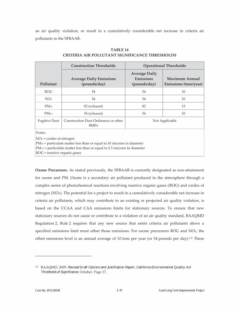
Case No. 2012.0054E E-97 Sunol Long Term Improvements Project
an air quality violation, or result in a cumulatively considerable net increase in criteria air
pollutants in the SFBAAB.
TABLE 14 CRITERIA AIR POLLUTANT SIGNIFICANCE THRESHOLDS
Pollutant
Construction Thresholds Operational Thresholds
Average Daily Emissions (pounds/day)
Average Daily Emissions
(pounds/day) Maximum Annual
Emissions (tons/year)
ROG 54 54 10
NOX 54 54 10
PM10 82 (exhaust) 82 15
PM2.5 54 (exhaust) 54 10
Fugitive Dust Construction Dust Ordinance or other BMPs
Not Applicable
Notes:
NOX = oxides of nitrogen PM10 = particulate matter less than or equal to 10 microns in diameter PM2.5 = particulate matter less than or equal to 2.5 microns in diameter ROG = reactive organic gases
Ozone Precursors. As stated previously, the SFBAAB is currently designated as non-attainment
for ozone and PM. Ozone is a secondary air pollutant produced in the atmosphere through a
complex series of photochemical reactions involving reactive organic gases (ROG) and oxides of
nitrogen (NOX). The potential for a project to result in a cumulatively considerable net increase in
criteria air pollutants, which may contribute to an existing or projected air quality violation, is
based on the CCAA and CAA emissions limits for stationary sources. To ensure that new
stationary sources do not cause or contribute to a violation of an air quality standard, BAAQMD
Regulation 2, Rule 2 requires that any new source that emits criteria air pollutants above a
specified emissions limit must offset those emissions. For ozone precursors ROG and NOX, the
offset emissions level is an annual average of 10 tons per year (or 54 pounds per day).121 These
121 BAAQMD, 2009. Revised Draft Options and Justification Report, California Environmental Quality Act Thresholds of Significance. October. Page 17.

Case No. 2012.0054E E-98 Sunol Long Term Improvements Project
levels represent emissions by which new sources are not anticipated to contribute to an air
quality violation or result in a considerable net increase in criteria air pollutants.
Particulate Matter (PM10 and PM2.5).122 The federal New Source Review (NSR) program was
created by the federal CAA to ensure that stationary sources of air pollution are constructed in a
manner that is consistent with attainment of federal health-based ambient air quality standards.
For PM10 and PM2.5, the emissions limit under NSR is 15 tons per year (82 pounds per day) and
10 tons per year (54 pounds per day), respectively. These emissions limits represent levels at
which a source is not expected to have an impact on air quality.123 Although the regulations
specified above apply to new or modified stationary sources, land use development projects
result in ROG, NOX, PM10, and PM2.5 emissions as a result of increases in vehicle trips,
architectural coating, and construction activities. Therefore, the thresholds specified above can be
applied to the construction and operational phases of land use projects, and those projects that
result in emissions below these thresholds would not be considered to contribute to an existing or
projected air quality violation or result in a considerable net increase in ozone precursors or PM.
Due to the temporary nature of construction activities, only the average daily thresholds are
applicable to construction-phase emissions.
Fugitive Dust. Fugitive dust emissions are typically generated during construction phases.
Studies have shown that the application of BMPs at construction sites significantly control
fugitive dust.124 Individual measures have been shown to reduce fugitive dust by anywhere from
30 to 90 percent.125 The BAAQMD has identified a number of BMPs to control fugitive dust
emissions from construction activities.126 The City’s Construction Dust Control Ordinance
(Ordinance 176-08, effective July 30, 2008) requires a number of fugitive dust control measures to
ensure that construction projects do not result in visible dust. The BMPs employed in compliance
122 PM10 is often termed “coarse” particulate matter, and is made of particulates that are 10 microns in diameter or smaller. PM2.5, termed “fine” particulate matter, is composed of particles that are 2.5 microns or less in diameter.
123 BAAQMD, 2009. Revised Draft Options and Justification Report, California Environmental Quality Act Thresholds of Significance. October. Page 16.
124 Western Regional Air Partnership, 2006. WRAP Fugitive Dust Handbook. September 7. Available online at: http://www.wrapair.org/forums/dejf/fdh/content/FDHandbook_Rev_06.pdf, accessed February 16, 2012.
125 BAAQMD, 2009. Revised Draft Options and Justification Report, California Environmental Quality Act Thresholds of Significance. October. Page 27.
126 BAAQMD, 2011. California Environmental Quality Act Air Quality Guidelines. May.

Case No. 2012.0054E E-99 Sunol Long Term Improvements Project
with the City’s Construction Dust Control Ordinance provide an effective strategy for controlling
construction-related fugitive dust.
Local Health Risks and Hazards
In addition to criteria air pollutants, individual projects may emit toxic air contaminants (TACs).
TACs collectively refer to a diverse group of air pollutants that are capable of causing chronic
(i.e., of long-duration) and acute (i.e., severe but of short-term) adverse effects to human health,
including carcinogenic effects. Human health effects of TACs include birth defects, neurological
damage, cancer, and mortality. There are hundreds of different types of TACs, with varying
degrees of toxicity. Individual TACs vary greatly in the health risk they present; at a given level
of exposure, one TAC may pose a hazard that is many times greater than another
Unlike criteria air pollutants, TACs do not have ambient air quality standards, but are regulated
by the BAAQMD using a risk-based approach to determine which sources and pollutants to
control, as well as the degree of control. A health risk assessment is an analysis in which human
health exposure to toxic substances is estimated, and considered together with information
regarding the toxic potency of the substances, to provide quantitative estimates of health risks.127
Air pollution does not affect every individual in the population in the same way, and some
groups are more sensitive to adverse health effects than others. Land uses such as residences,
schools, children’s day-care centers, hospitals, and nursing and convalescent homes are
considered to be the most sensitive to poor air quality because the population groups associated
with these uses have increased susceptibility to respiratory distress; or, as in the case of
residential receptors, their exposure time is greater than for other land uses. Therefore, these
groups are referred to as sensitive receptors. Exposure assessment guidance typically assumes
that residences would be exposed to air pollution 24 hours per day, 350 days per year, for
70 years. Therefore, assessments of air pollutant exposure to residents typically result in the
greatest adverse health outcomes of all population groups.
127 In general, a health risk assessment is required if the BAAQMD concludes that projected emissions of a specific air toxic compound from a proposed new or modified source suggest a potential public health risk. The applicant is then subject to a health risk assessment for the source in question. Such an assessment generally evaluates chronic, long-term effects, estimating the increased risk of cancer as a result of exposure to one or more TACs.
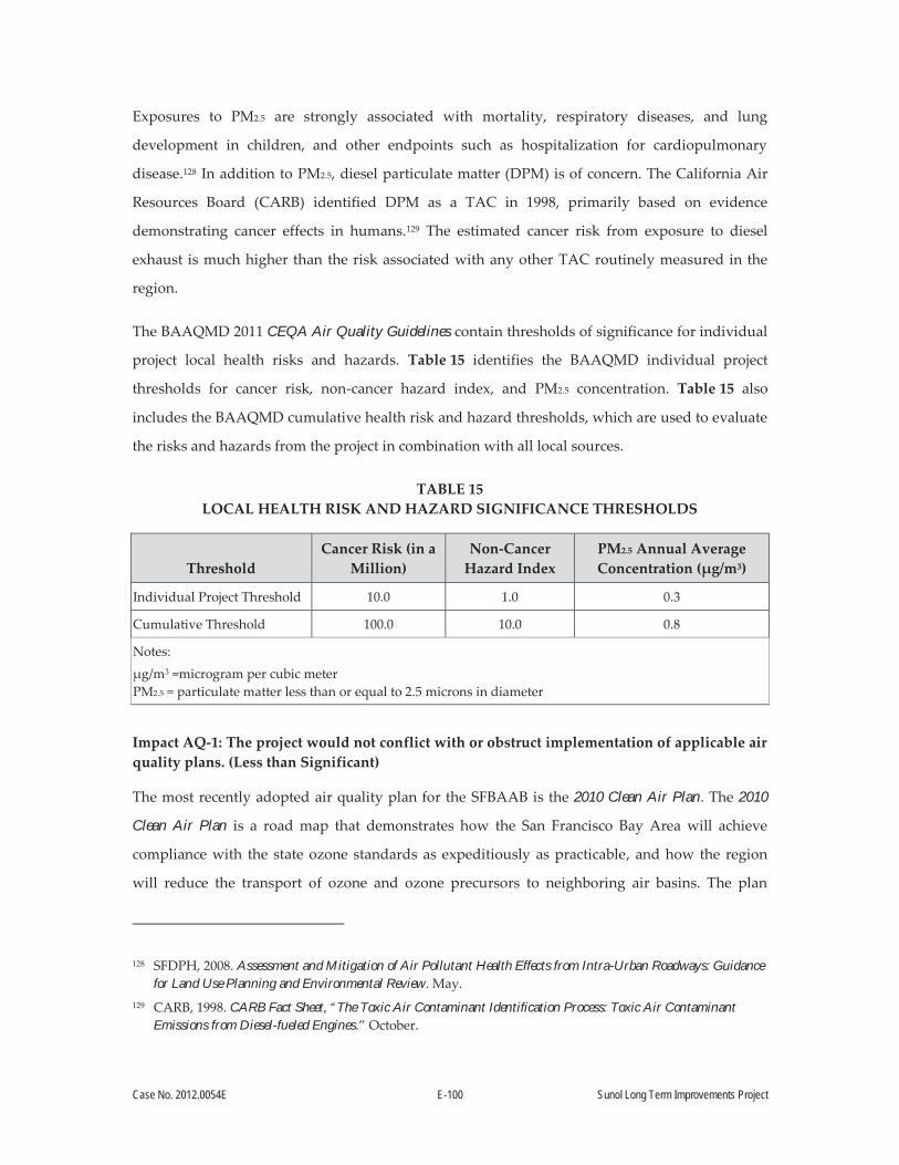
Case No. 2012.0054E E-100 Sunol Long Term Improvements Project
Exposures to PM2.5 are strongly associated with mortality, respiratory diseases, and lung
development in children, and other endpoints such as hospitalization for cardiopulmonary
disease.128 In addition to PM2.5, diesel particulate matter (DPM) is of concern. The California Air
Resources Board (CARB) identified DPM as a TAC in 1998, primarily based on evidence
demonstrating cancer effects in humans.129 The estimated cancer risk from exposure to diesel
exhaust is much higher than the risk associated with any other TAC routinely measured in the
region.
The BAAQMD 2011 CEQA Air Quality Guidelines contain thresholds of significance for individual
project local health risks and hazards. Table 15 identifies the BAAQMD individual project
thresholds for cancer risk, non-cancer hazard index, and PM2.5 concentration. Table 15 also
includes the BAAQMD cumulative health risk and hazard thresholds, which are used to evaluate
the risks and hazards from the project in combination with all local sources.
TABLE 15 LOCAL HEALTH RISK AND HAZARD SIGNIFICANCE THRESHOLDS
Threshold Cancer Risk (in a
Million) Non-Cancer
Hazard Index PM2.5 Annual Average Concentration (μg/m3)
Individual Project Threshold 10.0 1.0 0.3
Cumulative Threshold 100.0 10.0 0.8
Notes:
μg/m3 =microgram per cubic meter PM2.5 = particulate matter less than or equal to 2.5 microns in diameter
Impact AQ-1: The project would not conflict with or obstruct implementation of applicable air quality plans. (Less than Significant)
The most recently adopted air quality plan for the SFBAAB is the 2010 Clean Air Plan. The 2010
Clean Air Plan is a road map that demonstrates how the San Francisco Bay Area will achieve
compliance with the state ozone standards as expeditiously as practicable, and how the region
will reduce the transport of ozone and ozone precursors to neighboring air basins. The plan
128 SFDPH, 2008. Assessment and Mitigation of Air Pollutant Health Effects from Intra-Urban Roadways: Guidance for Land Use Planning and Environmental Review. May.
129 CARB, 1998. CARB Fact Sheet, “The Toxic Air Contaminant Identification Process: Toxic Air Contaminant Emissions from Diesel-fueled Engines.” October.

Case No. 2012.0054E E-101 Sunol Long Term Improvements Project
builds on the main objective of the 2005 Ozone Strategy, which was to comply with state air
quality planning requirements as mandated by the CCAA. The Bay Area Ozone Attainment Plan
was adopted by BAAQMD in 2001 in response to the U.S. Environmental Protection Agency’s
finding of failure of the Bay Area to attain the national ambient air quality standard for ozone.
The Bay Area Ozone Attainment Plan includes a control strategy for ozone and its precursors, to
ensure reduction in emissions from stationary sources, mobile sources, and the transportation
sector.
The thresholds of significance in the BAAQMD 2011 CEQA Air Quality Guidelines were
established to be consistent with the air quality attainment plans. As discussed under
Impact AQ-2, below, emissions from project construction and project operations would not
exceed the thresholds of significance, and would therefore be consistent with the applicable
plans. As a result, the project would not conflict with or obstruct the implementation of the
applicable air quality plans, and the impact would be Less than Significant.
Impact AQ-2: Project construction activities would generate fugitive dust and criteria air pollutants, and could violate applicable air quality standards. (Less than Significant)
Construction activities (short-term) typically result in emissions of ozone precursors and PM in
the form of dust (fugitive dust) and exhaust (e.g., vehicle tailpipe emissions). Emissions of ozone
precursors and PM are primarily a result of the combustion of fuel from on-road and off-road
vehicles. However, ROGs are also emitted from activities that involve painting, other types of
architectural coatings, or asphalt paving. The proposed project includes site preparation,
demolition, excavation, building construction, and paving. During the project’s approximately
24-month total construction period (including construction activities at the Sunol Yard and the
Watershed Center), construction activities would have the potential to result in emissions of
ozone precursors and PM.
Emissions from off-road construction equipment use, generator use, hauling truck trips, and
worker vehicle trips during the construction period were calculated using California Emissions
Estimator Model (CalEEMod) 2013, In-Use Off-Road Diesel Vehicle Regulation (OFFROAD) 2011,
OFFROAD2007, and Emission Factors Model (EMFAC) 2011. Details of the assumptions and
calculation methodologies are included in the Sunol Long Term Improvements Project Air Quality
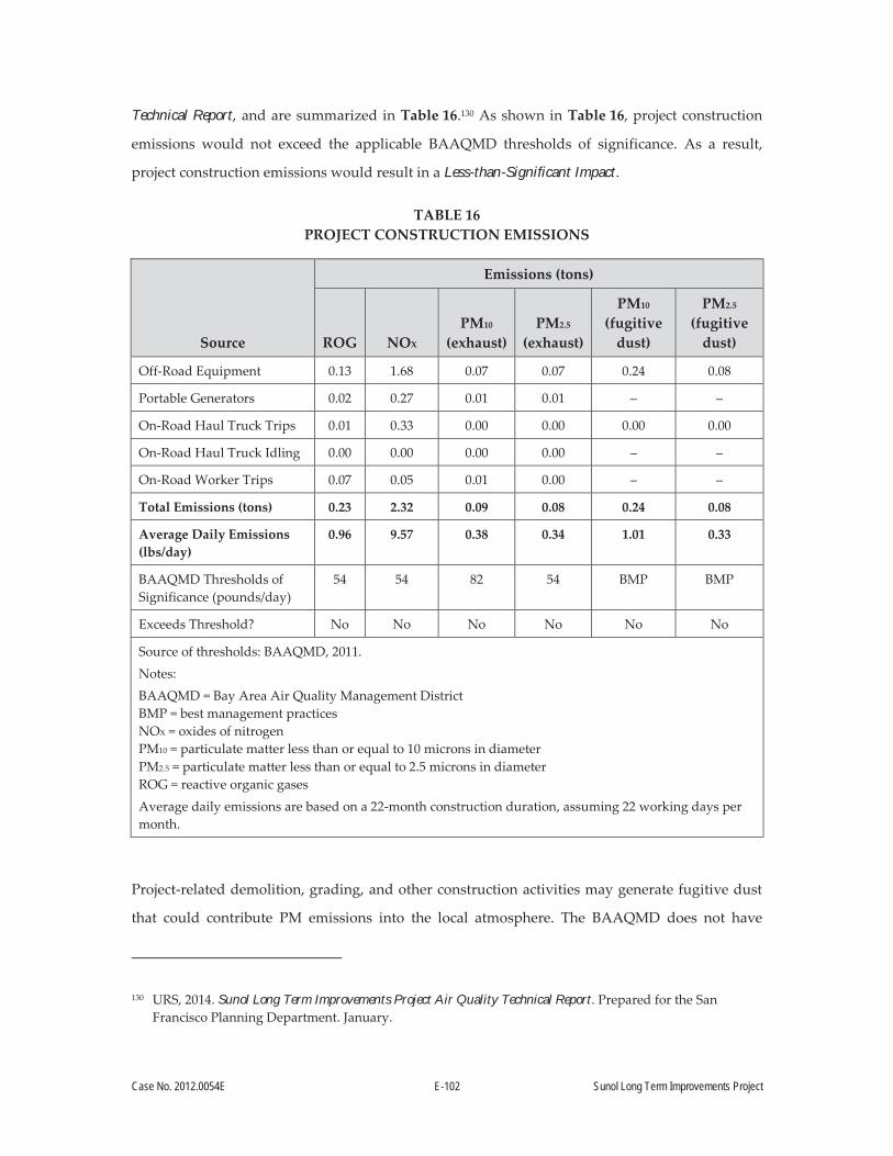
Case No. 2012.0054E E-102 Sunol Long Term Improvements Project
Technical Report, and are summarized in Table 16.130 As shown in Table 16, project construction
emissions would not exceed the applicable BAAQMD thresholds of significance. As a result,
project construction emissions would result in a Less-than-Significant Impact.
TABLE 16 PROJECT CONSTRUCTION EMISSIONS
Source
Emissions (tons)
ROG NOX PM10
(exhaust) PM2.5
(exhaust)
PM10
(fugitive dust)
PM2.5 (fugitive
dust)
Off-Road Equipment 0.13 1.68 0.07 0.07 0.24 0.08
Portable Generators 0.02 0.27 0.01 0.01 – –
On-Road Haul Truck Trips 0.01 0.33 0.00 0.00 0.00 0.00
On-Road Haul Truck Idling 0.00 0.00 0.00 0.00 – –
On-Road Worker Trips 0.07 0.05 0.01 0.00 – –
Total Emissions (tons) 0.23 2.32 0.09 0.08 0.24 0.08
Average Daily Emissions (lbs/day)
0.96 9.57 0.38 0.34 1.01 0.33
BAAQMD Thresholds of Significance (pounds/day)
54 54 82 54 BMP BMP
Exceeds Threshold? No No No No No No
Source of thresholds: BAAQMD, 2011.
Notes:
BAAQMD = Bay Area Air Quality Management District BMP = best management practices NOX = oxides of nitrogen PM10 = particulate matter less than or equal to 10 microns in diameter PM2.5 = particulate matter less than or equal to 2.5 microns in diameter ROG = reactive organic gases
Average daily emissions are based on a 22-month construction duration, assuming 22 working days per month.
Project-related demolition, grading, and other construction activities may generate fugitive dust
that could contribute PM emissions into the local atmosphere. The BAAQMD does not have
130 URS, 2014. Sunol Long Term Improvements Project Air Quality Technical Report. Prepared for the San Francisco Planning Department. January.
Case No. 2012.0054E E-103 Sunol Long Term Improvements Project
quantitative mass emission thresholds for fugitive dust emissions, but recommends that BMPs,
such as the “Basic Construction Mitigation Measures” listed in Table 8-1 in the BAAQMD 2011
CEQA Air Quality Guidelines, be implemented to reduce potential fugitive dust impacts during
construction activities.131 The SFPUC Standard Construction Measures (see Section A.5.8,
Standard Construction Measures) include the implementation of BMPs that are consistent with
the BAAQMD 2011 CEQA Air Quality Guidelines. Therefore, fugitive dust impacts during
construction would be Less than Significant.
Operation of the project would result in emissions from on-road worker and visitor vehicle trips,
emergency generators, fugitive emissions from fuel storage and dispensing, and area sources,
such as landscaping, architectural coatings, and combustion of natural gas on site. Emissions
from these sources were calculated using CalEEMod2013, EMFAC2011, and manual spreadsheet
calculations. Details of the assumptions and calculation methodologies are included in the above-
referenced Sunol Long Term Improvements Project Air Quality Technical Report, and are summarized
in Table 17.132 As shown in Table 17, project operational emissions would not exceed the
applicable BAAQMD thresholds of significance for annual or daily operational emissions. As a
result, project operational emissions impacts would be Less than Significant.
131 BAAQMD, 2011. California Environmental Quality Act Air Quality Guidelines. May. 132 URS, 2014. Sunol Long Term Improvements Project Air Quality Technical Report. Prepared for the San
Francisco Planning Department. January.

Case No. 2012.0054E E-104 Sunol Long Term Improvements Project
TABLE 17 PROJECT OPERATIONAL EMISSIONS
Source
Emissions (tons/year)
ROG NOX PM10
(exhaust) PM2.5
(exhaust)
Emergency Generator 0.00 0.03 0.00 0.00
Refueling Station Fugitive Emissions 0.04 – – –
Landscaping 0.34 0.00 0.00 0.00
Natural Gas Combustion 0.01 0.09 0.01 0.01
Mobile Sources 0.30 0.96 0.01 0.01
Total Annual Emissions (tons/year) 0.69 1.08 0.02 0.02
BAAQMD Thresholds of Significance (tons/year) 10 10 15 10
Exceeds Threshold? No No No No
Average Daily Emissions (pounds/day) 3.80 5.91 0.11 0.11
BAAQMD Thresholds of Significance (lbs/day) 54 54 82 54
Exceeds Threshold? No No No No
Source of thresholds: BAAQMD 2011.
Notes:
BAAQMD = Bay Area Air Quality Management District NOX = oxides of nitrogen PM10 = particulate matter less than or equal to 10 microns in diameter PM2.5 = particulate matter less than or equal to 2.5 microns in diameter ROG = reactive organic gases
Impact AQ-3: The project could result in a cumulatively considerable net increase of any criteria pollutant for which the project region is non-attainment under an applicable federal, state, or regional ambient air quality standard (including releasing emissions that exceed quantitative thresholds for ozone precursors). (Less than Significant)
The BAAQMD 2011 CEQA Air Quality Guidelines state that if the project construction emissions
do not exceed any of the applicable criteria pollutant or precursor thresholds, the project would
result in a less-than-significant impact on both an individual and cumulative basis. Similarly, if
the project operational emissions do not exceed any of the applicable criteria pollutant or
precursor thresholds, the project would result in a less-than-significant impact on both an
individual and cumulative basis. As shown above in Impact AQ-2), project construction
emissions and project operational emissions would not exceed BAAQMD significance thresholds.
Therefore, the project would result in a Less-than-Significant cumulative impact.
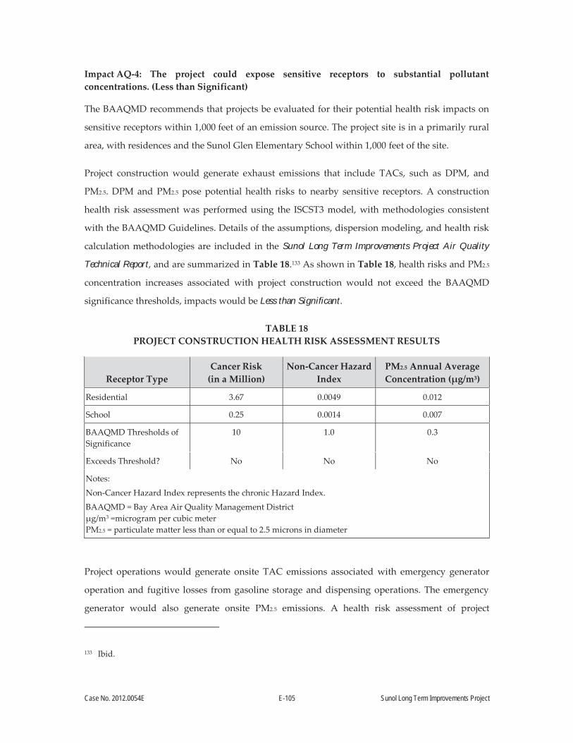
Case No. 2012.0054E E-105 Sunol Long Term Improvements Project
Impact AQ-4: The project could expose sensitive receptors to substantial pollutant concentrations. (Less than Significant)
The BAAQMD recommends that projects be evaluated for their potential health risk impacts on
sensitive receptors within 1,000 feet of an emission source. The project site is in a primarily rural
area, with residences and the Sunol Glen Elementary School within 1,000 feet of the site.
Project construction would generate exhaust emissions that include TACs, such as DPM, and
PM2.5. DPM and PM2.5 pose potential health risks to nearby sensitive receptors. A construction
health risk assessment was performed using the ISCST3 model, with methodologies consistent
with the BAAQMD Guidelines. Details of the assumptions, dispersion modeling, and health risk
calculation methodologies are included in the Sunol Long Term Improvements Project Air Quality
Technical Report, and are summarized in Table 18.133 As shown in Table 18, health risks and PM2.5
concentration increases associated with project construction would not exceed the BAAQMD
significance thresholds, impacts would be Less than Significant.
TABLE 18 PROJECT CONSTRUCTION HEALTH RISK ASSESSMENT RESULTS
Receptor Type Cancer Risk
(in a Million) Non-Cancer Hazard
Index PM2.5 Annual Average Concentration (μg/m3)
Residential 3.67 0.0049 0.012
School 0.25 0.0014 0.007
BAAQMD Thresholds of Significance
10 1.0 0.3
Exceeds Threshold? No No No
Notes:
Non-Cancer Hazard Index represents the chronic Hazard Index.
BAAQMD = Bay Area Air Quality Management District μg/m3 =microgram per cubic meter PM2.5 = particulate matter less than or equal to 2.5 microns in diameter
Project operations would generate onsite TAC emissions associated with emergency generator
operation and fugitive losses from gasoline storage and dispensing operations. The emergency
generator would also generate onsite PM2.5 emissions. A health risk assessment of project
133 Ibid.

Case No. 2012.0054E E-106 Sunol Long Term Improvements Project
operations was performed using the ISCST3 model, with methodologies consistent with the
BAAQMD Guidelines. Details of the assumptions, dispersion modeling, and health risk
calculation methodologies are included in the Sunol Long Term Improvements Project Air Quality
Technical Report, and are summarized in Table 19.134 As shown in Table 19, health risks and PM2.5
concentration increases associated with project operations would not exceed the BAAQMD
significance thresholds, impacts would be Less than Significant.
TABLE 19 PROJECT OPERATION HEALTH RISK ASSESSMENT RESULTS
Receptor Type Cancer Risk
(in a Million) Non-Cancer Hazard
Index PM2.5 Annual Average Concentration (μg/m3)
Residential 0.37 0.0003 0.0003
School 0.01 0.0001 0.0002
BAAQMD Thresholds of Significance
10 1.0 0.3
Exceeds Threshold? No No No
Notes:
Non-Cancer Hazard Index represents the chronic Hazard Index. BAAQMD = Bay Area Air Quality Management District μg/m3 =microgram per cubic meter PM2.5 = particulate matter less than or equal to 2.5 microns in diameter
A cumulative health risk analysis was also performed to examine the cumulative health risk
impacts from project construction, project operation, and other local sources. The BAAQMD
Stationary Source Screening Tool was used to identify health risks from permitted stationary
sources within 1,000 feet of the project site. The BAAQMD Screening Tables for PM2.5
Concentrations and Cancer Risks Generated from Surface Streets was also used to identify health
risks from high-volume roadways within 1,000 feet of the project site. Details of the assumptions
and methodologies used in this cumulative analysis are included in the above-referenced Air
Quality Technical Report, and are summarized in Table 20. These tools identified one stationary
source (FID 130, Plant No. 13551) and one high-volume roadway (SR 84) as local health risk
sources. Table 20 shows the screening health risks from these local sources, and also shows that
134 Ibid.
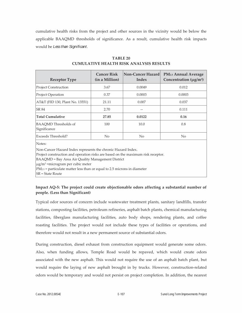
Case No. 2012.0054E E-107 Sunol Long Term Improvements Project
cumulative health risks from the project and other sources in the vicinity would be below the
applicable BAAQMD thresholds of significance. As a result, cumulative health risk impacts
would be Less than Significant.
TABLE 20 CUMULATIVE HEALTH RISK ANALYSIS RESULTS
Receptor Type Cancer Risk
(in a Million) Non-Cancer Hazard
Index PM2.5 Annual Average Concentration (μg/m3)
Project Construction 3.67 0.0049 0.012
Project Operation 0.37 0.0003 0.0003
AT&T (FID 130, Plant No. 13551) 21.11 0.007 0.037
SR 84 2.70 -- 0.111
Total Cumulative 27.85 0.0122 0.16
BAAQMD Thresholds of Significance
100 10.0 0.8
Exceeds Threshold? No No No
Notes:
Non-Cancer Hazard Index represents the chronic Hazard Index. Project construction and operation risks are based on the maximum risk receptor. BAAQMD = Bay Area Air Quality Management District μg/m3 =microgram per cubic meter PM2.5 = particulate matter less than or equal to 2.5 microns in diameter SR = State Route
Impact AQ-5: The project could create objectionable odors affecting a substantial number of people. (Less than Significant)
Typical odor sources of concern include wastewater treatment plants, sanitary landfills, transfer
stations, composting facilities, petroleum refineries, asphalt batch plants, chemical manufacturing
facilities, fiberglass manufacturing facilities, auto body shops, rendering plants, and coffee
roasting facilities. The project would not include these types of facilities or operations, and
therefore would not result in a new permanent source of substantial odors.
During construction, diesel exhaust from construction equipment would generate some odors.
Also, when funding allows, Temple Road would be repaved, which would create odors
associated with the new asphalt. This would not require the use of an asphalt batch plant, but
would require the laying of new asphalt brought in by trucks. However, construction-related
odors would be temporary and would not persist on project completion. In addition, the nearest

Case No. 2012.0054E E-108 Sunol Long Term Improvements Project
receptor is approximately 825 feet away, and odors would likely dissipate before reaching the
receptor. Therefore, the project would not create a significant source of new odors, and odor
impacts would be Less than Significant.
Impact C-AQ: Project construction or operation would not result in a cumulatively considerable net increase of any criteria pollutant or precursors for which the project region is non-attainment under an applicable federal, state, or regional ambient air quality standard. (Less than Significant)
Regional air pollution is by its very nature largely a cumulative impact. Emissions from past,
present and future projects contribute to the region’s adverse air quality on a cumulative basis.
No single project by itself would be sufficient in size to result in regional nonattainment of
ambient air quality standards. Instead, a project’s individual emissions contribute to existing
cumulative adverse air quality impacts.135 The project-level thresholds for criteria air pollutants
are based on levels by which new sources are not anticipated to contribute to an air quality
violation or result in a considerable net increase in criteria air pollutants. Project emissions are
compared below to BAAQMD thresholds, which indicate whether or not emissions would be
cumulatively considerable.
To address cumulative impacts on regional air quality, the thresholds of significance for
construction related criteria pollutants and precursor emissions have been developed, which
represent the levels at which a project’s individual emissions of criteria pollutants and precursors
would result in a cumulatively considerable contribution to the SFBAAB’s existing air quality
violations. If average daily emissions exceed these thresholds, the project would result in a
cumulatively significant impact. As indicated in Table 15 above, construction-related criteria
pollutant and precursor emissions associated with the project would not exceed the applicable
significance thresholds, and therefore the project’s contribution to any significant cumulative
impacts on regional air quality would not be cumulatively considerable (Less Than Significant).
135 BAAQMD, 2011. California Environmental Quality Act Air Quality Guidelines. May. Page 2-1.
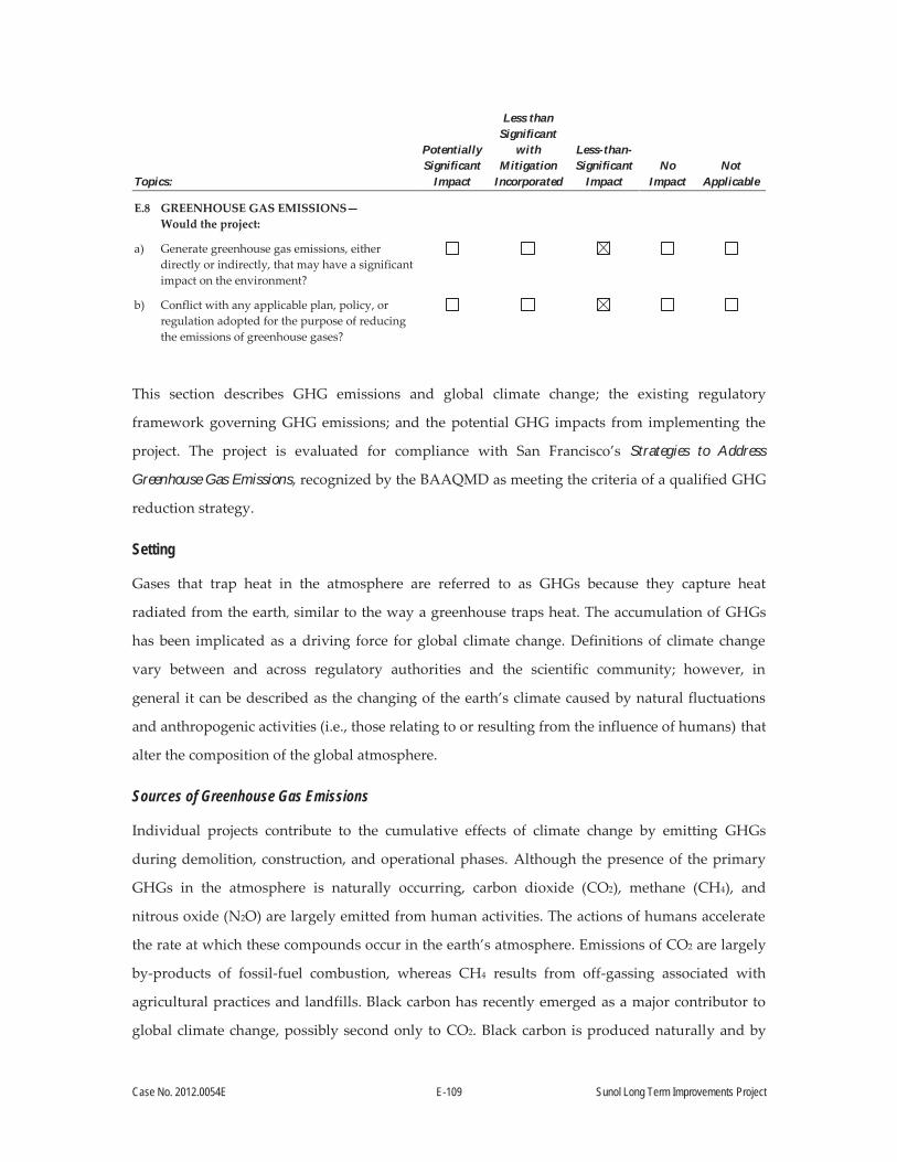
Case No. 2012.0054E E-109 Sunol Long Term Improvements Project
Topics:
Potentially Significant
Impact
Less than Significant
with Mitigation
Incorporated
Less-than-Significant
Impact No
Impact Not
Applicable
E.8 GREENHOUSE GAS EMISSIONS— Would the project:
a) Generate greenhouse gas emissions, either directly or indirectly, that may have a significant impact on the environment?
b) Conflict with any applicable plan, policy, or regulation adopted for the purpose of reducing the emissions of greenhouse gases?
This section describes GHG emissions and global climate change; the existing regulatory
framework governing GHG emissions; and the potential GHG impacts from implementing the
project. The project is evaluated for compliance with San Francisco’s Strategies to Address
Greenhouse Gas Emissions, recognized by the BAAQMD as meeting the criteria of a qualified GHG
reduction strategy.
Setting
Gases that trap heat in the atmosphere are referred to as GHGs because they capture heat
radiated from the earth, similar to the way a greenhouse traps heat. The accumulation of GHGs
has been implicated as a driving force for global climate change. Definitions of climate change
vary between and across regulatory authorities and the scientific community; however, in
general it can be described as the changing of the earth’s climate caused by natural fluctuations
and anthropogenic activities (i.e., those relating to or resulting from the influence of humans) that
alter the composition of the global atmosphere.
Sources of Greenhouse Gas Emissions
Individual projects contribute to the cumulative effects of climate change by emitting GHGs
during demolition, construction, and operational phases. Although the presence of the primary
GHGs in the atmosphere is naturally occurring, carbon dioxide (CO2), methane (CH4), and
nitrous oxide (N2O) are largely emitted from human activities. The actions of humans accelerate
the rate at which these compounds occur in the earth’s atmosphere. Emissions of CO2 are largely
by-products of fossil-fuel combustion, whereas CH4 results from off-gassing associated with
agricultural practices and landfills. Black carbon has recently emerged as a major contributor to
global climate change, possibly second only to CO2. Black carbon is produced naturally and by
Case No. 2012.0054E E-110 Sunol Long Term Improvements Project
human activities as a result of the incomplete combustion of fossil fuels, biofuels, and biomass.136
N2O is a byproduct of various industrial processes and has a number of uses, including as an
anesthetic and an aerosol propellant. Other GHGs include hydrofluorocarbons, perfluorocarbons,
and sulfur hexafluoride, which are generated in certain industrial processes. GHGs are typically
reported in “carbon dioxide-equivalent” measures (CO2e).137
There is international scientific consensus that human-caused increases in GHGs have
contributed to and will continue to contribute to climate change. Many impacts resulting from
climate change, including increased fires, floods, severe storms, and heat waves, are occurring
already and will only become more frequent and more costly.138 Secondary effects of climate
change are likely to include a global rise in sea level; impacts on agriculture, the state’s electricity
system, and native freshwater fish ecosystems; changes in disease vectors; and changes in habitat
and biodiversity.139,140
CARB estimated that in 2011 California produced about 448 million gross metric tons of CO2e
(MMTCO2e; about 494 million U.S. tons of CO2e).141 CARB found that transportation is the source
of 38 percent of the state’s GHG emissions, followed by industrial sources at 21 percent and
electricity generation at 19 percent (both in-state generated and imported electricity). Commercial
and residential fuel use (primarily for heating) accounted for 10 percent of GHG emissions.142
136 Center for Climate and Energy Solutions, 2010. What is Black Carbon? April. Available online at: http://www.c2es.org/docUploads/what-is-black-carbon.pdf. Accessed May 20, 2013.
137 Because of the differential heat absorption potential of various GHGs, GHG emissions are frequently measured in “carbon dioxide-equivalents,” which present a weighted average based on each gas’ heat absorption (or “global warming”) potential.
138 California Natural Resources Agency, 2009. 2009 California Climate Adaptation Strategy Discussion Draft, 2009, Sacramento. pp. 48–55.
139 California Climate Change Portal, 2013. Available online at: http://www.climatechange.ca.gov.http://www.climatechange.ca.gov. Accessed December 12, 2013.
140 California Energy Commission, 2013. Our Changing Climate 2012. Available online at: http://www.energy.ca.gov/publications/CEC-500-2012-007/CEC500-2012-007.pdf. Accessed December 12, 2013.
141 The abbreviation for “million metric tons” is MMT; million metric tons of CO2 equivalents is written as MMTCO2E.
142 CARB, 2014. “California Greenhouse Gas Inventory for 2000-2011—by Category as Defined in the 2008 Scoping Plan,” Available online at: http://www.arb.ca.gov/cc/inventory/data/tables/ghg_inventory_scopingplan_00-11_2013-08-01.pdf. Accessed November 6, 2013.

Case No. 2012.0054E E-111 Sunol Long Term Improvements Project
In the Bay Area, fossil fuel consumption in the transportation sector (on-road motor vehicles, off-
highway mobile sources, and aircraft) and the industrial/commercial sector were the two largest
sources of GHG emissions. Together, they accounted for about 36 percent of the Bay Area’s
95.8 MMTCO2e emissions in 2007. Industrial and commercial electricity and fossil-fuel
consumption (including office and retail) were the second-largest contributors of GHG emissions,
at about 34 percent of total emissions. Electricity generation accounts for approximately 16 percent
of the Bay Area’s GHG emissions. This is followed by residential fuel use (e.g., home water heaters
and furnaces) at 7 percent, off-road equipment at 3 percent, and agriculture at 12 percent. Among
industrial sources, oil refining currently accounts for more than 40 percent of GHG emissions, or
approximately 15 percent of the total Bay Area GHG emissions.143
Regulatory Setting
In 2005, in recognition of California’s vulnerability to the effects of climate change, then-Governor
Schwarzenegger established Executive Order S-3-05, which set forth a series of target dates by
which statewide GHGs emissions would be progressively reduced: by 2010, reduce GHG emissions
to 2000 levels (approximately 457 MMTCO2e); by 2020, reduce emissions to 1990 levels (estimated
at 427 MMTCO2e); and by 2050 reduce statewide GHG emissions to 80 percent below 1990 levels
(approximately 85 MMTCO2e).
In response, the California legislature passed Assembly Bill (AB) 32 in 2006 (California Health
and Safety Code Division 25.5, Sections 38500, et seq., or AB 32), also known as the Global
Warming Solutions Act. AB 32 requires CARB to design and implement emission limits,
regulations, and other measures, so that feasible and cost-effective statewide GHG emissions are
reduced to 1990 levels by 2020 (representing a 25 percent reduction from forecast emission
levels).144
Pursuant to AB 32, CARB adopted a scoping plan in December 2008, outlining measures to meet
the 2020 GHG reduction limits. The scoping plan is the state’s overarching plan for addressing
143 BAAQMD, 2010. Source Inventory of Bay Area Greenhouse Gas Emissions: Base Year 2007. February. Available online at: http://www.baaqmd.gov/~/media/Files/Planning%20and%20Research/Emission%20Inventory/regionalinventory2007_2_10.ashx. Accessed November 6, 2013.
144 OPR, 2008. Technical Advisory – CEQA and Climate Change: Addressing Climate Change through California Environmental Quality Act (CEQA) Review. June 19. Available online at: http://opr.ca.gov/docs/june08-ceqa.pdf. Accessed May 22, 2013.
Case No. 2012.0054E E-112 Sunol Long Term Improvements Project
climate change. To meet these goals, California must reduce its GHG emissions by 30 percent
below projected 2020 business-as-usual emissions levels, or about 15 percent from 2008 levels.145
The scoping plan estimates a reduction of 174 MMTCO2e from the transportation, energy,
agriculture, forestry, and high global warming potential sectors (see Table 21, below). In the
scoping plan, CARB identified an implementation timeline for the GHG reduction strategies.146
CARB is currently updating the 2008 scoping plan, and the 2013 update to the scoping plan will
include CARB’s climate change priorities for the next 5 years. Additionally, it will lay the
groundwork to reach post-2020 goals set forth in Executive Order S-3-05.
The AB 32 scoping plan recommendations are intended to curb projected business-as-usual
growth in GHG emissions, and to reduce those emissions to 1990 levels. Therefore, meeting
AB 32 GHG reduction goals would result in an overall annual net decrease in GHGs, compared
to current levels, even accounting for projected increases in emissions resulting from anticipated
growth.
The scoping plan also relies on the requirements of Senate Bill (SB) 375 to implement the carbon
emission reductions anticipated from land use decisions. SB 375 was enacted to align local land use
and transportation planning to further achieve California’s GHG reduction goals. SB 375 requires
regional transportation plans, developed by metropolitan planning organizations, to incorporate a
“sustainable communities strategy” in their regional transportation plans that would achieve GHG
emission reduction targets set by CARB. SB 375 also includes provisions for streamlined CEQA
review for some infill projects, such as transit-oriented development. SB 375 would be implemented
over the next several years. Plan Bay Area, the Bay Area Metropolitan Transportation
Commission’s 2013 Regional Transportation Plan, is the first plan subject to SB 375.
145 CARB, 2010. California’s Climate Plan: Fact Sheet. Available online at: http://www.arb.ca.gov/cc/facts/scoping_plan_fs.pdf. Accessed May 22, 2013.
146 CARB, 2013. Assembly Bill 32 Overview. Available online at: http://www.arb.ca.gov/cc/ab32/ab32.htm/. Accessed May 22, 2013.
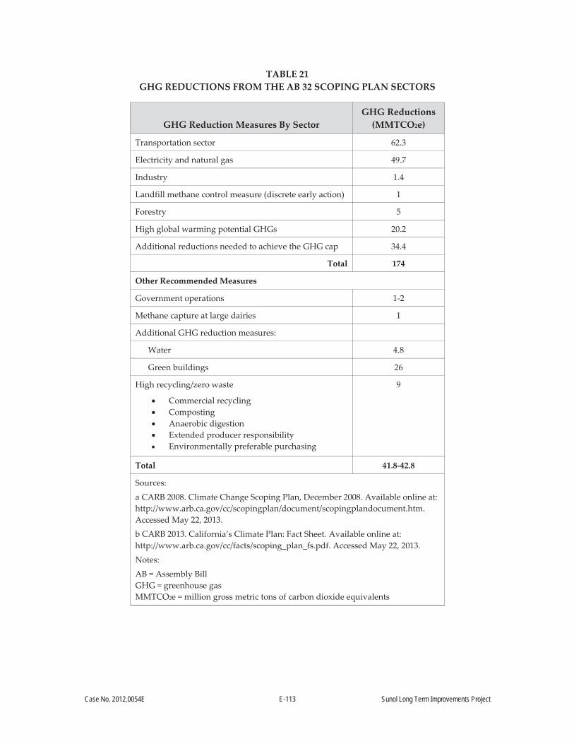
Case No. 2012.0054E E-113 Sunol Long Term Improvements Project
TABLE 21 GHG REDUCTIONS FROM THE AB 32 SCOPING PLAN SECTORS
GHG Reduction Measures By Sector GHG Reductions
(MMTCO2e)
Transportation sector 62.3
Electricity and natural gas 49.7
Industry 1.4
Landfill methane control measure (discrete early action) 1
Forestry 5
High global warming potential GHGs 20.2
Additional reductions needed to achieve the GHG cap 34.4
Total 174
Other Recommended Measures
Government operations 1-2
Methane capture at large dairies 1
Additional GHG reduction measures:
Water 4.8
Green buildings 26
High recycling/zero waste
Commercial recycling Composting Anaerobic digestion Extended producer responsibility Environmentally preferable purchasing
9
Total 41.8-42.8
Sources:
a CARB 2008. Climate Change Scoping Plan, December 2008. Available online at: http://www.arb.ca.gov/cc/scopingplan/document/scopingplandocument.htm. Accessed May 22, 2013.
b CARB 2013. California’s Climate Plan: Fact Sheet. Available online at: http://www.arb.ca.gov/cc/facts/scoping_plan_fs.pdf. Accessed May 22, 2013.
Notes:
AB = Assembly Bill GHG = greenhouse gas MMTCO2e = million gross metric tons of carbon dioxide equivalents

Case No. 2012.0054E E-114 Sunol Long Term Improvements Project
AB 32 further anticipates that local government actions will reduce GHG emissions. CARB has
identified a GHG reduction target of 15 percent from current levels for local governments
themselves, and notes that successful implementation of the scoping plan relies on local
governments’ land use planning and urban growth decisions. This is because local governments
have the primary authority to plan, zone, approve, and permit land development to
accommodate population growth and the changing needs of their jurisdictions.147 The BAAQMD
has analyzed the effectiveness of the region in meeting AB 32 goals from the actions outlined in
the scoping plan. It determined that, to meet AB 32 GHG reduction goals, the Bay Area would
need to achieve an additional 2.3 percent reduction in GHG emissions from the land use–driven
sector.148
SB 97 required the Governor’s Office of Planning and Research (OPR) to amend the state CEQA
guidelines to address the feasible mitigation of GHG emissions or the effects of GHGs. In
response, OPR amended the CEQA guidelines to provide guidance for analyzing GHG
emissions. Among other changes to the CEQA Guidelines, the amendments added a new section
to the CEQA Checklist (CEQA Guidelines Appendix G) to address questions regarding the
project’s potential to emit GHGs.
The BAAQMD is the primary agency responsible for regulating air quality in the nine-county
SFBAAB. The BAAQMD recommends that local agencies adopt a GHG reduction strategy
consistent with AB 32 goals. The BAAQMD also recommends that subsequent projects be
reviewed to determine the significance of their GHG emissions, based on the degree to which
that project complies with a GHG reduction strategy.149 As described below, this
recommendation is consistent with the approach to analyzing GHG emissions outlined in the
CEQA guidelines.
147 CARB, 2008. Climate Change Scoping Plan. December. Available online at: http://www.arb.ca.gov/cc/scopingplan/document/adopted_scoping_plan.pdf. Accessed November 6, 2013.
148 BAAQMD, 2009. California Environmental Quality Act Guidelines Update, Proposed Thresholds of Significance. December. Available online at: http://www.baaqmd.gov/~/media/Files/Planning%20and%20Research/CEQA/Proposed%20Thresholds%20of%20Significance%20Dec%207%2009.ashx. Accessed November 6, 2013.
149 BAAQMD, 2012. California Environmental Quality Act Air Quality Guidelines, updated May 2012. Available online at: http://www.baaqmd.gov/~/media/Files/Planning%20and%20Research/CEQA/BAAQMD%20CEQA%20Guidelines_Final_May%202012.ashx?la=en. Accessed November 6, 2013.

Case No. 2012.0054E E-115 Sunol Long Term Improvements Project
At a local level, CCSF has developed a number of plans and programs to reduce its contribution
to global climate change. San Francisco’s GHG reduction goals, as outlined in the 2008
Greenhouse Gas Reduction Ordinance, are as follows:
By 2008, determine CCSF’s GHG emissions for 1990, which is the baseline level against
which reductions are measured;
By 2017, reduce GHG emissions by 25 percent below 1990 levels;
By 2025, reduce GHG emissions by 40 percent below 1990 levels; and
By 2050, reduce GHG emissions by 80 percent below 1990 levels.
CCSF’s Greenhouse Gas Reduction Strategy documents its actions to pursue cleaner energy, to
conserve energy, and to adopt alternative transportation and solid waste policies. As identified in
the strategy, CCSF has implemented a number of mandatory requirements and incentives that
have measurably reduced GHG emissions. These include the following: increasing the energy
efficiency of new and existing buildings; installing solar panels on building roofs; implementing a
green building strategy; adopting a zero waste strategy; enacting a construction and demolition
debris recovery ordinance; establishing a solar energy generation subsidy; incorporating
alternative fuel vehicles in the City’s transportation fleet (including buses); and enacting a
mandatory recycling and composting ordinance. The strategy also identifies 42 specific
regulations for new development that would reduce CCSF’s GHG emissions.
The Greenhouse Gas Reduction Strategy concludes that CCSF’s policies and programs have
reduced GHG emissions below 1990 levels, exceeding statewide AB 32 GHG reduction goals. As
reported, San Francisco’s communitywide 1990 GHG emissions were approximately
6.15 MMTCO2e. A recent third-party verification of San Francisco’s 2010 communitywide and
municipal emissions inventory has confirmed that San Francisco has reduced its GHG emissions
to 5.26 MMTCO2e, representing a 14.5 percent reduction in GHG emissions below 1990
levels.150,151
150 ICF International, 2012. “Technical Review of the 2010 Community-wide GHG Inventory for the City and County of San Francisco.” Memorandum from ICF International to San Francisco Department of the Environment. April 10. Available online at: http://www.sfenvironment.org/sites/default/files/fliers/files/icf_memo_to_sfe_-_2010_community-wide_ghg_inventory_-_4.10.2012.pdf. Accessed November 6, 2013.
151 ICF International, 2012. “Technical Review of San Francisco’s 2010 Municipal GHG Inventory.” Memorandum from ICF International to San Francisco Department of the Environment. May 8.
Case No. 2012.0054E E-116 Sunol Long Term Improvements Project
Approach to Analysis
In compliance with SB 97, OPR amended the CEQA Guidelines to address the feasible mitigation
of GHG emissions or the effects of GHGs. Among other changes to the CEQA Guidelines, the
amendments added a new section to the CEQA Checklist (CEQA Guidelines Appendix G) to
address questions regarding the project’s potential to emit GHGs. The potential for a project to
result in significant GHG emissions that contribute to the cumulative effects on global climate
change is based on the CEQA Guidelines and CEQA Checklist, as amended by SB 97; and is
determined by an assessment of the project’s compliance with local and state plans, policies, and
regulations adopted for the purpose of reducing the cumulative effects of climate change. GHG
emissions are analyzed in the context of their contribution to the cumulative effects of climate
change, because a single land use project could not generate enough GHG emissions to
noticeably change the global average temperature. CEQA Guidelines Sections 15064.4
and 15183.5 address the analysis and determination of significant impacts from a proposed
project’s GHG emissions. CEQA Guidelines Section 15183.5 allows for public agencies to analyze
and mitigate GHG emissions as part of a larger plan for the reduction of GHGs, and describes the
required contents of such a plan. As discussed above, San Francisco has prepared its own
Greenhouse Gas Reduction Strategy, demonstrating that San Francisco’s policies and programs
have collectively reduced communitywide GHG emissions to below 1990 levels, meeting GHG
reduction goals outlined in AB 32. The City is also well on its way to meeting the long-term GHG
reduction goal of reducing emissions 80 percent below 1990 levels by 2050. Chapter 1 of the City’s
Strategies to Address Greenhouse Gas Emission (the Greenhouse Gas Reduction Strategy) describes
how the strategy meets the requirements of CEQA Guidelines Section 15183.5. The BAAQMD has
reviewed San Francisco’s Greenhouse Gas Reduction Strategy, concluding that “Aggressive GHG
reduction targets and comprehensive strategies like San Francisco’s help the Bay Area move
Available online at: http://www.sfenvironment.org/sites/default/files/fliers/files/memo_to_sfe_-_2010_municipal_ghg_inventory_-_icf_international_-_8_may_2012_-_final.pdf. Accessed November 6, 2013.
Case No. 2012.0054E E-117 Sunol Long Term Improvements Project
toward reaching the state’s AB 32 goals, and also serve as a model from which other communities
can learn.”152
With respect to CEQA Guidelines Section 15064.4(b), the factors to be considered in making a
significance determination include: 1) the extent to which GHG emissions would increase or
decrease as a result of the proposed project; 2) whether or not a proposed project exceeds a
threshold that the lead agency determines applies to the project; and 3) demonstrating
compliance with plans and regulations adopted for the purpose of reducing or mitigating GHG
emissions.
The GHG analysis provided below includes a qualitative assessment of GHG emissions that would
result from a proposed project, including emissions from an increase in vehicle trips, natural gas
combustion, and/or electricity use, among other factors. Consistent with the CEQA Guidelines and
BAAQMD recommendations for analyzing GHG emissions, the significance standard applied to
GHG emissions generated during project construction and operational phases is based on whether
the project complies with a plan for the reduction of GHG emissions. The City’s Greenhouse Gas
Reduction Strategy is the City’s overarching plan documenting the policies, programs and
regulations that the City implements towards reducing municipal and communitywide GHG
emissions. In particular, San Francisco implements 42 specific regulations that reduce GHG
emissions, which are applied to projects in the City. Projects that comply with the Greenhouse Gas
Reduction Strategy would not result in a substantial increase in GHGs, because the City has shown
that overall communitywide GHGs have decreased and that the City has met AB 32 GHG
reduction targets. Individual project compliance with the City’s Greenhouse Gas Reduction
Strategy is demonstrated by completion of the Compliance Checklist for Greenhouse Gas Analysis.
In summary, the two applicable GHG reduction plans—the AB 32 Scoping Plan and the City’s
Greenhouse Gas Reduction Strategy—are intended to reduce GHG emissions below current levels.
Given that the City’s local GHG reduction targets are more aggressive than the state’s 2020 GHG
reduction targets, and consistent with the long-term 2050 reduction targets, the City’s Greenhouse
Gas Reduction Strategy is consistent with the goals of AB 32. Therefore, proposed projects that are
152 Roggenkamp, J., 2010. October 28, 2010, letter from Jean Roggenkamp, BAAQMD to Bill Wycko, City
of San Francisco Planning Department, regarding Draft GHG Reduction Strategy. Available online at:
http://www.sf-planning.org/ftp/files/MEA/GHG-Reduction_Letter.pdf.
Case No. 2012.0054E E-118 Sunol Long Term Improvements Project
consistent with the City’s Greenhouse Gas Reduction Strategy would be consistent with the goals of
AB 32; would not conflict with either plan; and would therefore not exceed San Francisco’s
applicable GHG threshold of significance. Furthermore, a locally compliant project would not result
in a substantial increase in GHGs.
The following analysis of the proposed project’s impact on climate change focuses on the
project’s contribution to cumulatively significant GHG emissions. Given that the analysis is in a
cumulative context, this section does not include an individual project-specific impact statement.
Impact C-GG: The project would not generate GHG emissions at levels that would result in a significant impact on the environment or conflict with any policy, plan, or regulation adopted for the purpose of reducing GHG emissions. (Less than Significant)
The most common GHGs resulting from human activity are CO2, CH4, and N2O.153 The project
could temporarily contribute directly to these GHG emissions during construction as a result of
emissions from construction equipment and haul trucks delivering materials and transporting
wastes offsite (natural gas combustion). Indirect emissions would result from electricity
providers; energy required to pump, treat, and convey water; and emissions associated with
landfill operations. The project would not result in a substantial increase in GHG emissions once
construction is completed, because there would be little change to baseline conditions relative to
operation of the Sunol Yard, including the addition of the Watershed Center, given that the
Administration Building at the Sunol Yard and the Watershed Center would be designed and
constructed to conform to California Title 24 energy use standards and would aim to secure
LEED Gold certification to reduce environmental effects and enhance energy efficiency (see
Section A.5.1, Facilities, above).
The proposed project would be subject to and required to comply with several regulations
adopted to reduce GHG emissions, as identified in the City’s Greenhouse Gas Reduction
Strategy. The regulations that are applicable to the proposed project include the Clean
Construction Ordinance, Resource Efficiency and Green Building Ordinance, Resource
Conservation Ordinance, Mandatory Recycling and Composting Ordinance, and the Stormwater
Management Ordinance and Construction Pollution Prevention Ordinance. As discussed above,
153 OPR, 2008. Technical Advisory—CEQA and Climate Change: Addressing Climate Change through California Environmental Quality Act (CEQA) Review. June 19. Available online at: http://opr.ca.gov/docs/june08-ceqa.pdf. Accessed August 8, 2013.

Case No. 2012.0054E E-119 Sunol Long Term Improvements Project
and consistent with the state CEQA Guidelines and BAAQMD recommendations for analyzing
GHG emissions under CEQA, projects that are consistent with San Francisco’s Strategies to
Address Greenhouse Gas Emissions would result in a less-than-significant GHG impact. Based on an
assessment of the project’s compliance with San Francisco’s Strategies to Address Greenhouse Gas
Emissions, the project was determined to be consistent with San Francisco’s GHG Reduction
Strategy.154
Given that: 1) San Francisco has implemented regulations to reduce GHG emissions specific to
new construction and renovations of private developments and municipal projects; 2) San
Francisco’s sustainable policies have resulted in the measured reduction of annual GHG
emissions; 3) San Francisco has met and exceeds AB 32 GHG reduction goals for the year 2020,
and is on track towards meeting long-term GHG reduction goals; 4) current and probable future
state and local GHG reduction measures will continue to reduce a project’s contribution to
climate change; and 5) San Francisco’s Strategies to Address Greenhouse Gas Emissions meet the
CEQA and BAAQMD requirements for a Greenhouse Gas Reduction Strategy, projects that are
consistent with San Francisco’s regulations would not contribute significantly to global climate
change. The proposed project would be required to comply with the requirements listed above,
and was determined to be consistent with San Francisco’s Strategies to Address Greenhouse Gas
Emissions. Therefore, the proposed project would result in a Less-than-Significant Impact with
respect to GHG emissions.
154 San Francisco Planning Department, 2014. Compliance Checklist Table for Greenhouse Gas Analysis: Table 2. Municipal Projects. March 3.

Case No. 2012.0054E E-120 Sunol Long Term Improvements Project
Topics:
Potentially Significant
Impact
Less than Significant
with Mitigation
Incorporated
Less-than-Significant
Impact No
Impact Not
Applicable
E.9 WIND AND SHADOW—Would the project:
a) Alter wind in a manner that substantially affects public areas?
b) Create new shadow in a manner that substantially affects outdoor recreation facilities or other public areas?
Existing public areas on the project site include the Sunol Water Temple Agricultural Park, Sunol
Water Temple, and a picnic area. The project would construct improvements at the Sunol Yard, a
new Watershed Center, and improvements to the existing picnic area. Improvements at the Sunol
Yard would result in some increase in the number and size of buildings on the site, but none of
these buildings would be of a tall or wide enough to result in a change to wind on the site, and
they would not affect wind at the public areas on the site.
The existing outdoor picnic area is in the project area, southwest of the proposed Watershed
Center. The one-story Watershed Center would not be tall or wide enough to result in a change in
wind at the existing picnic facilities.
Additionally, neither the improvements at the Sunol Yard nor the one-story Watershed Center
would be tall enough to create any shadow that substantially affects outdoor recreation areas or
facilities. For these reasons, the project would have No Impact on wind and shadow.

Case No. 2012.0054E E-121 Sunol Long Term Improvements Project
Topics:
Potentially Significant
Impact
Less than Significant
with Mitigation
Incorporated
Less-than-Significant
Impact No
Impact Not
Applicable
E.10 RECREATION—Would the project:
a) Increase the use of existing neighborhood and regional parks or other recreational facilities such that substantial physical deterioration of the facilities would occur or be accelerated?
b) Include recreational facilities or require the construction or expansion of recreational facilities that might have an adverse physical effect on the environment?
c) Physically degrade existing recreational resources?
Impact RE-1: The project would not increase the use of existing neighborhood and regional parks or other recreational facilities to the extent that substantial physical deterioration of the facilities would occur or be accelerated. (Less than Significant)
The project does not propose the construction of housing or other features that would result in an
increase in the use of existing recreational facilities. However, the project would result in the
construction of the new Watershed Center, and improvements to—and the re-opening of—the
existing picnic area. The new Watershed Center and picnic area improvements would likely
result in an increase in visitation to the existing Sunol Water Temple Agricultural Park and the
currently closed onsite picnic area. The Sunol Water Temple Agricultural Park is a facility
designed for visitor use and public education. The Agricultural Park accommodates tours and
educational programs by appointment for visitors of all ages. Improvements to the picnic area
would include an ADA-compliant access path and stairs, new picnic tables, and a play structure
for children. However, it can be reasonably assumed that these facilities would be likely be
subject to ongoing monitoring and maintenance such that they would not substantially
deteriorate due to the proposed increase in use. The Sunol Water Temple would be closed to
visitors during the construction period (approximately 24 months). Between 20 and 50 people
visit the Sunol Water Temple each day, according to the SFPUC.155 It is reasonable to assume that
some percentage of these visitors would travel to alternate recreational facilities (e.g., East Bay
155 SFPUC, 2013. SFPUC Responses to URS Request for Information (RFI dated 10/1/2013). Sunol Long Term Improvements Project. October.

Case No. 2012.0054E E-122 Sunol Long Term Improvements Project
Regional Park lands such as the Pleasanton Ridge Regional Park to the north and Sunol Regional
Wilderness to the south), thereby increasing their use during this period. However, the additional
use of these facilities would be relatively minor, given the small number of increased visitors,
over approximately 24 months, and therefore, it can be reasonably assumed that they would not
cause substantial physical deterioration of these facilities. As a result, this impact would be Less
than Significant.
Impact RE-2: The project would include recreational facilities, the construction of which could have an adverse physical effect on the environment. (Less than Significant with Mitigation Incorporated)
The project proposes the re-opening of the existing onsite picnic area, and the construction and
operation of a new Watershed Center and a new “Discovery Trail.” As stated above,
improvements to the existing onsite picnic area would include an ADA-compliant access path
and stairs, new picnic tables, and a play structure for children. The existing abandoned restroom
facilities would be removed, and new restrooms provided at the Watershed Center. The existing
barbed-wire–topped fence at the picnic area would be replaced with a low-height perimeter fence
and gate consistent with recreational uses. The picnic area is south of the Sunol Water Temple,
and consists primarily of landscaped vegetation adjacent to Alameda Creek (see Figure 14,
below). Provision of new picnic tables and a children’s play structure would involve little to no
ground disturbance.
As described in the Project Description, the SFPUC has established Standard Construction
Measures to be included in all construction contracts. The Standard Construction Measures
stipulate that all construction contractors must implement construction stormwater BMPs. At a
minimum, construction contractors would be required to undertake the following measures, as
applicable, to minimize adverse effects of construction activities on water quality: erosion and
sedimentation controls tailored to the site and project; installation of silt fences, use of wind
erosion control (e.g., geotextile or plastic covers on stockpiled soil); and stabilization of site
ingress/egress locations to minimize erosion. These measures would avoid or reduce impacts on
existing resources.
Also, the project would disturb more than 1 acre of soil, and would therefore be subject to the
provisions and requirements of the Construction General Permit, as detailed in Section A.7,
Required Actions and Approvals. Construction activities subject to this permit include, but are
not limited to, clearing, grading, stockpiling, and excavation. Among other provisions, the

Case No. 2012.0054E E-123 Sunol Long Term Improvements Project
Construction General Permit requires the development and implementation of a Storm Water
Pollution Prevention Plan (SWPPP), which would include and specify BMPs designed to prevent
pollutants from contacting stormwater, and keep all products of erosion from moving off site into
receiving waters.
Construction of the Watershed Center would require grading, excavation, and the building of
structures, which have the potential to result in environmental impacts. These activities would
result in impacts that would be Less than Significant with Mitigation Incorporated to Cultural
Resources and Biological Resources. Discussions of these impacts and mitigation measures are
presented in Sections E.4 and E.13, respectively. Implementation of Mitigation
Measure M-CP-1a, Historic Resources Protection Plan; Mitigation Measure M-CP-1b,
Preconstruction Surveys and Vibration Monitoring; Mitigation Measure M-CP-2a, Treatment
of Known Archaeological Resources; Mitigation Measure M-CP-2b, Archaeological
Monitoring and Accidental (Post-review) Discovery of Archaeological Resources; Mitigation
Measure M-CP-4, Accidental Discovery of Human Remains; Mitigation Measure M BI 1a,
Nesting Bird Survey Protection; and Mitigation Measure M-BI 1b, Preconstruction Survey for
San Francisco Dusky-Footed Woodrat would reduce these impacts to less than significant (Less
than Significant with Mitigation Incorporated).
Impact RE-3: The project would not physically degrade existing recreational resources. (No Impact)
The project proposes improvements to, and the re-opening of, the existing onsite picnic area.
Improvements to the existing onsite picnic area would include an ADA-compliant access path
and stairs, new picnic tables, and a play structure for children. The existing abandoned restroom
facilities would be removed, and new restrooms provided at the Watershed Center. The existing
barbed-wire–topped fence at the picnic area would be replaced with a low-height perimeter fence
and gate consistent with recreational uses. These components would improve these facilities,
which were in need of repair. In addition, construction of the new Watershed Center would
integrate the picnic facilities into an additional public use area, creating an improved security
connection for the facilities. Therefore, the proposed project would improve rather than
physically degrade existing recreational resources. As a result, there would be No Impact.

Case No. 2012.0054E E-124 Sunol Long Term Improvements Project
Impact C-RE: The proposed project, in combination with past, present, and reasonably foreseeable future projects in the vicinity, would not result in a cumulative impact on recreation. (No Impact)
The geographic scope of potential recreation impacts includes the project site, immediate vicinity,
and other recreational facilities in the area. Cumulative impacts on the environment could occur
if the development of additional recreation facilities were required as a result of the cumulative
projects identified in Table 9 or if increased use of existing facilities could result in their
degradation or deterioration due to implementation of these identified cumulative projects.
The project and other identified planned or proposed cumulative projects (see Table 9, above) do
not include increases in housing or other aspects that would result in substantial increases in
potential recreationists using recreation resources in the project vicinity. Given the wide variety
and quantity of nearby public open space and recreational opportunities, the proposed project
would not increase the use of these public facilities such that substantial physical deterioration of
existing facilities would occur or be accelerated. Further, the proposed project would provide an
improved recreational experience at the Sunol Water Temple by adding the Watershed Center
and updating and reopening the adjacent picnic area. For these reasons, the project, in
combination with other past, present, and reasonably foreseeable future projects, would not
result in a cumulative impact on recreation (No Impact).

Case No. 2012.0054E E-125 Sunol Long Term Improvements Project
Topics:
Potentially Significant
Impact
Less than Significant
with Mitigation
Incorporated
Less-than-Significant
Impact No
Impact Not
Applicable
E.11 UTILITIES AND SERVICE SYSTEMS— Would the project:
a) Exceed wastewater treatment requirements of the applicable Regional Water Quality Control Board?
b) Require or result in the construction of new water or wastewater treatment facilities or expansion of existing facilities, the construction of which could cause significant environmental effects?
c) Require or result in the construction of new storm water drainage facilities or expansion of existing facilities, the construction of which could cause significant environmental effects?
d) Have sufficient water supply available to serve the project from existing entitlements and resources, or require new or expanded water supply resources or entitlements?
e) Result in a determination by the wastewater treatment provider that would serve the project that it has inadequate capacity to serve the project’s projected demand in addition to the provider’s existing commitments?
f) Be served by a landfill with sufficient permitted capacity to accommodate the project’s solid waste disposal needs?
g) Comply with federal, state, and local statutes and regulations related to solid waste?
Impact UT 1: The project would not require or result in the construction of new or the need for expansion of existing wastewater treatment or water supply facilities, the construction of which could cause significant environmental effects, or require new or expanded water supply entitlements to serve the project. (Less than Significant)
The project would result in the demolition of buildings on site, and construction of new facilities.
A staff residence and guest house would be demolished and not replaced. Proposed facilities at
the Sunol Yard include new shops, a replacement administration building, several covered
storage structures, and associated outbuildings and structures. Two replacement wastewater
holding tanks would be installed at the Sunol Yard, and existing underground fuel tanks would
be replaced with new above-ground fuel tanks at the relocated fueling station. The project would
also complete minor improvements for the Carrefour, Temple Road, and the existing picnic area,

Case No. 2012.0054E E-126 Sunol Long Term Improvements Project
as well as construct a new Watershed Center, including installation of an underground
wastewater holding tank and subsurface electrical power and water connections (see
Section A.4.1, Sunol Corporation Yard Improvements; and Section A.5.1, Facilities, above).
Sunol Yard administrative staff is office-based, and manages and supports the overall function of
various SFPUC departments based in Sunol. There would be little change in the operation and
maintenance of improved project facilities at the Sunol Yard. No additional staffing would be
needed to operate and maintain the proposed facilities; although it is planned that additional
office staff will use the Sunol Yard following project completion. Currently, approximately 47
staff use the Sunol Yard, an estimated 31 of whom work full time in the field. Approximately 61
staff are expected to use Sunol Yard following completion.
The Watershed Center would be staffed with approximately four employees. The site would be
open to the general public, and for project planning and design purposes, the SFPUC estimates
that the completed project could attract up to 100 visitors each day that it is open. An existing
restroom at the picnic area would be demolished, existing portable restrooms at the Sunol Water
Temple would be removed, and the replacement restrooms would be located at the proposed
Watershed Center. The new restrooms at the Watershed Center would require a new connection
to existing water service, and an underground holding tank would be installed to contain the
wastewater. Wastewater would be pumped from the tank and transported to a wastewater
treatment facility.
Wastewater from the Sunol vicinity is treated at the San Jose-Santa Clara Regional Wastewater
Facility which treats an average of 110 million gallons of wastewater per day, and has the
capacity to clean up to 167 million gallons per day.156 Water is supplied to the project site by the
SFPUC. According to the 2010 Urban Water Management Plan, sufficient water supplies are
available to serve the overall water demand of its Sunol service area. As of 2010, the current
sustainable water supply was 265 million gallons per day (mgd). This amount is expected to
remain relatively constant through 2035. SFPUC’s normal water year demand is expected to
increase from 149.5 mgd in 2010 to 198.5 mgd in 2035.157
156 San José-Santa Clara Regional Wastewater Facility, About the Facility. Available online at: http://sanjoseca.gov/index.aspx?nid=1663, Accessed August 6, 2014.
157 SFPUC, 2011. 2010 Urban Water Management Plan. July.
Case No. 2012.0054E E-127 Sunol Long Term Improvements Project
Improvements at Sunol Yard would result in a small increase in the number of staff on site (an
additional 14 staff at the Sunol Yard). Also, as noted above, for project planning and design
purposes, the SFPUC estimates that there could be up to 100 visitors to the Watershed Center and
picnic area each day that it is open. As part of the SFPUC’s goal for LEED Gold Certification,
high-efficiency toilets (1.28 gallons per flush) and water faucets (flow rate of 0.6 gallon per
minute) would be installed.158 It is assumed for purposes of this analysis that up to 75 percent of
the visitors to the Watershed Center would use the restrooms. With an additional 18 staff and 75
visitors potentially requiring restroom use per weekday, that would equal 93 additional persons
using water at Sunol Yard and Watershed Center combined each weekday, using an average of
1.88 gallons per day. This equates to approximately 175 additional gallons of water per weekday
being used, and an equal amount of wastewater generated per weekday due to the proposed
project. This increase would not create a substantial new demand for water, nor would it
generate substantial additional wastewater requiring treatment, given that the estimated increase
in water use and wastewater generation is so low compared to the region’s existing water supply
and wastewater capacity.
During construction, water would be supplied by water trucks, if necessary, and sanitary needs
would be provided by portable sanitary equipment serviced by an outside contractor. Project
operation and maintenance activities would involve periodic cleaning, maintenance of
equipment, and testing of backup generators. Periodic cleaning of the buildings on the site would
be similar to what currently exists, and would require only minimal amounts of water, which
would be provided from the existing water service. Therefore, potential impacts relative to
significance criteria 11a, 11b, 11d, and 11e regarding the need for treatment of wastewater, the
need for new or expanded wastewater treatment facilities, or the need for expanded water supply
entitlements would be Less than Significant.
Impact UT 2: The project would require or result in the construction of new stormwater drainage facilities or expansion of existing facilities, the construction of which would not cause significant environmental effects. (Less than Significant)
New stormwater management features would be constructed at both sites. Landscaped areas
would be incorporated into the parking lot and road designs to facilitate rainwater infiltration.
158 Natural Resources Defense Council and Pacific Institute, 2014. Urban Water Conservation and Efficiency Potential in California. June.

Case No. 2012.0054E E-128 Sunol Long Term Improvements Project
The new storm drainage system would include infiltration trenches, catch basins, and swales (see
Section A.4.1, Sunol Corporation Yard Improvements, above). In support of securing LEED
Gold Certification, the stormwater management features for the Administration Building and the
Watershed Center would be designed to achieve the LEED SS6.2 credit, as required by the green
building requirements for the construction of CCSF municipal buildings.159 This credit deals with
the prevention of polluted runoff during and after construction, and uses total suspended solids
(TSS) as the indicator of level of pollution. Projects can use biological or mechanical treatment
methods for smaller and more frequent storms for credit compliance. To earn the credit, the
project must be able to show that the stormwater treatment system is effective at treating all
rainstorms for any year up to 90 percent of the average annual rainfall. In addition, as part of the
LEED Gold certification, the project must develop and implement construction activity pollution
prevention and stormwater management controls adopted by the SFPUC, and comply with the
Construction General Permit (LEED prerequisite SSp1). Therefore, the impact on the environment
from the construction of the proposed new stormwater drainage facilities would be Less than
Significant.
Impact UT 3: The project would be served by landfills with sufficient permitted capacity to accommodate the project’s solid waste disposal needs. (Less than Significant)
The project would result in the demolition of buildings on the site, and construction of new
buildings. Construction of the project would have limited solid waste disposal needs because it
would not require the disposal of substantial quantities of excavated soil or other construction
debris. Approximately 4,000 cubic yards of excavated soil and approximately 2,000 cubic yards of
building demolition waste would require recycling or disposal. Construction-related solid waste
such as construction material packaging and debris and spent fuel or water tanks would require
recycling or disposal, as applicable, in accordance with state and local solid waste regulations.
Where offsite disposal of soil is required, a local disposal facility would be identified.
Several regional disposal facilities are available to serve the project’s waste disposal needs,
including Vasco Road Sanitary Landfill (Alameda County) and Altamont Landfill (Alameda
County). The Vasco Road Sanitary Landfill has a remaining capacity of 9.8 million cubic yards,
159 CCSF, 2011. San Francisco Environment Code, Chapter 7, Green Building Requirements for City Buildings.

Case No. 2012.0054E E-129 Sunol Long Term Improvements Project
with an estimated closure date of 2019.160 The Altamont Landfill has a remaining capacity of
45.7 million cubic yards, with an estimated closure date of 2025.161
Collectively, these landfills have well over 56 million cubic yards of remaining capacity; accept all
the types of waste likely to be generated by the project; and will remain open during project
construction. During operation and maintenance, waste would be generated. However, because
the number of workers on site at the Sunol Yard would only increase by approximately 14
workers—and because the operations at the Watershed Center, by their nature, would not
generate a significant amount of waste—it is not anticipated that the project would result in a
substantial increase in the amount of waste generated. For these reasons, the impact of
construction, operation, and maintenance of the project on existing landfill capacity would be
Less than Significant.
Impact UT 4: The project would comply with federal, state, and local statutes and regulations related to solid waste. (No Impact)
As described above under Impact UT-3, the project would require the disposal of up to
2,000 cubic yards of demolition- and construction-related waste, and 4,000 cubic yards of
excavated material. Project operation and maintenance activities would generate a minor amount
of solid wastes requiring offsite disposal. AB 939, known as the California Integrated Waste
Management Act of 1989, required each city and/or county to reduce the amount of waste being
disposed to landfills to 50 percent by 2000. As of 2006, the California Integrated Waste
Management Board estimated a diversion rate of 69 percent for unincorporated Alameda
County.162
160 CalRecycle, 2014. Facility/Site Summary Details: Vasco Road Sanitary Landfill (01-AA-0010). Available online at: http://www.calrecycle.ca.gov/SWFacilities/Directory/01-AA-0010/Detail/. Accessed May 7, 2014.
161 CalRecycle, 2014. Facility/Site Summary Details: Altamont Landfill & Resource Recovery (01-AA-0009). Available online at: http://www.calrecycle.ca.gov/SWFacilities/Directory/01-AA-0009/Detail/. Accessed May 7, 2014.
162 CalRecycle, 2014. Disposal Reporting System (DRS) Jurisdiction Diversion Rate Percentage Trend (1995-2006). Available online at: http://www.calrecycle.ca.gov/LGCentral/Reports/Viewer.aspx?P=JurisdictionID%3d5%26ReportName%3dDiversionRateGraphPre2006%26ShowParameters%3dfalse%26AllowNullParameters%3dFalse. Accessed May 7, 2014.

Case No. 2012.0054E E-130 Sunol Long Term Improvements Project
The project is subject to San Francisco Environment Code, Chapter 7, Section 708, Construction
and Demolition Debris Management. This requirement applies to all construction and/or
demolition projects at City-owned facilities and city leaseholds, regardless of size of the project,
in the nine counties surrounding San Francisco Bay. It requires that all City departments ensure
that each construction and/or demolition project subject to this section shall meet the following
requirements:
1. The contractor shall employ the following hierarchy of highest and best use for handling
construction and demolition debris, as follows:
a. Implement reduced material usage or reuse of materials before any recycling;
b. Implement recycling of source-separated material before any recycling of mixed
construction and demolition debris material; and
c. Implement recycling of mixed construction and demolition debris before all other
forms of disposal.
2. The contractor shall manage all project construction and demolition debris materials to
meet a minimum diversion rate of 75 percent.
As discussed in Section E.16, Hazards and Hazardous Materials, excavated soil could be
classified as a hazardous waste. To determine the appropriate disposal facility for excavated
materials, excavated soils would be stockpiled, sampled, and analyzed for hazardous materials in
accordance with landfill criteria. Accordingly, the project would also be required to follow state
and federal regulations for the disposal of hazardous wastes at a permitted disposal or recycling
facility.
Therefore, because the project would comply with all applicable local, state, and federal laws and
regulations pertaining to solid waste, there would be No Impact.
Impact C-UT: The proposed project, in combination with past, present, and reasonably foreseeable future projects in the vicinity, would not result in a cumulative impact on utilities and service systems. (Less than Significant)
The geographic scope for potential cumulative utilities and service systems impacts consists of
the project area, its immediate vicinity, and the service areas of regional service/utility providers.
Wastewater in the project vicinity is treated by the San Jose-Santa Clara Regional Wastewater
Facility. Several regional disposal facilities are available to serve the proposed project and
cumulative projects listed in Table 9, including Vasco Road Sanitary Landfill (Alameda County)
and Altamont Landfill (Alameda County). Water is supplied to the project vicinity by the SFPUC.
Case No. 2012.0054E E-131 Sunol Long Term Improvements Project
All of the project listed in Table 9 could generate wastewater either during construction or
operation. The San Jose-Santa Clara Regional Wastewater Facility cleans an average of 110
million gallons of wastewater per day, and has the capacity to clean up to 167 million gallons per
day.163 The proposed project would generate up to an additional 175 gallons of wastewater
requiring treatment per day. Given that the wastewater treatment facility that serves the project
vicinity has an excess daily capacity of 57 million gallons per day, the proposed project in
combination with the cumulative project would not have a significant cumulative impact on
wastewater treatment facilities.
All of the projects listed in Table 9 would generate solid waste either during construction or
operation. A discussed under Impact UT-4, AB 939, known as the California Integrated Waste
Management Act of 1989, required each city and/or county to reduce the amount of waste being
disposed to landfills to 50 percent by 2000. As of 2006, the California Integrated Waste
Management Board (CIWMB) estimated a diversion rate of 69 percent for unincorporated
Alameda County.164 Also, the project is subject to San Francisco Environment Code, Chapter 7,
Section 708, Construction and Demolition Debris Management which requires that all City
departments ensure that each construction and/or demolition project subject to this Section shall
manage all project construction and demolition debris materials to meet a minimum diversion
rate of 75 percent The Vasco Road Sanitary Landfill has a remaining capacity of 9.8 million cubic
yards, with an estimated closure date of 2019.165 The Altamont Landfill has a remaining capacity
of 45.7 million cubic yards, with an estimated closure date of 2025.166 Collectively, these landfills
163 San José-Santa Clara Regional Wastewater Facility, About the Facility, http://sanjoseca.gov/index.aspx?nid=1663. Accessed August 6, 2014.
164 CalRecycle, 2014. Disposal Reporting System (DRS) Jurisdiction Diversion Rate Percentage Trend (1995-2006). Available online at: http://www.calrecycle.ca.gov/LGCentral/Reports/Viewer.aspx?P=JurisdictionID%3d5%26ReportName%3dDiversionRateGraphPre2006%26ShowParameters%3dfalse%26AllowNullParameters%3dFalse. Accessed May 7, 2014.
165 CalRecycle, 2014. Facility/Site Summary Details: Vasco Road Sanitary Landfill (01-AA-0010). Available online at: http://www.calrecycle.ca.gov/SWFacilities/Directory/01-AA-0010/Detail/. Accessed May 7, 2014.
166 CalRecycle, 2014. Facility/Site Summary Details: Altamont Landfill & Resource Recovery (01-AA-0009). Available online at: http://www.calrecycle.ca.gov/SWFacilities/Directory/01-AA-0009/Detail/. Accessed May 7, 2014.

Case No. 2012.0054E E-132 Sunol Long Term Improvements Project
have well over 56 million cubic yards of remaining capacity. The proposed project in combination
with the cumulative project would not have a significant cumulative impact on landfills.
The proposed project would obtain its potable water supply from SFPUC. According to the 2010
Urban Water Management Plan, sufficient water supplies are available to serve the overall water
demand of its Sunol service area. As of 2010, the current sustainable water supply was 265
million gallons per day (mgd). This amount is expected to remain relatively constant through
2035. SFPUC’s normal water year demand is expected to increase from 149.5 mgd in 2010 to 198.5
mgd in 2035.167 The proposed project in combination with the cumulative project would not have
a significant cumulative impact on water supply.
The proposed project would not be connected to any storm water drainage facilities.
Based on the discussion above, the proposed project in combination with the identified
cumulative projects would not have a significant cumulative impact on utilities (Less than
Significant).
167 SFPUC, 2011. 2010 Urban Water Management Plan. July.
Case No. 2012.0054E E-133 Sunol Long Term Improvements Project
Topics:
Potentially Significant
Impact
Less than Significant
with Mitigation
Incorporated
Less-than-Significant
Impact No
Impact Not
Applicable
E.12 PUBLIC SERVICES— Would the project:
a) Result in substantial adverse physical impacts associated with the provision of, or the need for, new or physically altered governmental facilities, the construction of which could cause significant environmental impacts, in order to maintain acceptable service ratios, response times, or other performance objectives for any public services such as fire protection, police protection, schools, parks, or other services?
The project does not propose the construction of housing or other features that would result in an
increase in population that would require the need for physically altered governmental facilities.
However, the project would result in the construction of the new Watershed Center; and
improvements to, and the re-opening of, the existing picnic area. The new Watershed Center and
picnic area improvements would likely result in an increase in visitation to Sunol Water Temple
Agricultural Park and the existing onsite picnic area. However, police and fire protection to these
facilities would be provided in the same manner as they currently are, and it is not anticipated
that visits to these facilities would increase to an extent that would require increasing fire
protection, police protection, schools, parks, or other services. Furthermore, newly constructed
Sunol Yard facilities would be improved to satisfy current building and fire codes. Therefore,
impacts relative to the potential need for new or expanded public services, the construction of
which could cause significant impacts on the environment, would be Less than Significant.
Impact C-PS: The proposed project, in combination with past, present, and reasonably foreseeable future projects in the vicinity, would not result in a cumulative impact on public services. (Less than Significant)
As the proposed project would not require an increase in fire protection, police protection,
schools, parks, or other services, it would not contribute to a cumulative impact relative to the
potential need for new or expanded public services, the construction of which could cause
significant impacts on the environment (Less than Significant).

Case No. 2012.0054E E-134 Sunol Long Term Improvements Project
Topics:
Potentially Significant
Impact
Less than Significant
with Mitigation
Incorporated
Less-than- Significant
Impact No
Impact Not
Applicable
E.13 BIOLOGICAL RESOURCES— Would the project:
a) Have a substantial adverse effect, either directly or through habitat modifications, on any species identified as a candidate, sensitive, or special-status species in local or regional plans, policies, or regulations, or by the California Department of Fish and Game or U.S. Fish and Wildlife Service?
b) Have a substantial adverse effect on any riparian habitat or other sensitive natural community identified in local or regional plans, policies, regulations or by the California Department of Fish and Game or U.S. Fish and Wildlife Service?
c) Have a substantial adverse effect on federally protected wetlands as defined by Section 404 of the Clean Water Act (including, but not limited to, marsh, vernal pool, coastal, etc.) through direct removal, filling, hydrological interruption, or other means?
d) Interfere substantially with the movement of any native resident or migratory fish or wildlife species or with established native resident or migratory wildlife corridors, or impede the use of native wildlife nursery sites?
e) Conflict with any local policies or ordinances protecting biological resources, such as a tree preservation policy or ordinance?
f) Conflict with the provisions of an adopted Habitat Conservation Plan, Natural Community Conservation Plan, or other approved local, regional, or state habitat conservation plan?
Approach to Analysis
Potential biological resource impacts are evaluated based on the following information:
1) special status species lists from the California Natural Diversity Database (CNDDB), USFWS,
the CDFW, and the California Native Plant Society (CNPS); and 2) results of field surveys of the
project area to characterize the existing conditions and evaluate the potential for special-status
species and wetlands to be present in the project area. A detailed assessment of potential

Case No. 2012.0054E E-135 Sunol Long Term Improvements Project
biological resource considerations for the proposed project is presented in the project Biological
Resources Survey Report.168
Special-Status Species Lists
Special-status species lists were derived from the CNDDB, USFWS, CDFW, and CNPS for the
Niles, La Costa Valley, Dublin, and Livermore 7.5-minute U.S. Geological Survey quadrangles.
The primary sources of data referenced for this study include:
Federal Endangered and Threatened Species that May be Affected by Projects in the
Niles, La Costa Valley, Dublin, and Livermore, California 7.5-minute topographic
quadrangles;
CNPS, Online Inventory of Rare and Endangered Plants;
CNDDB records for the Niles, La Costa Valley, Dublin, and Livermore, California
7.5-minute topographic quadrangles;169
CDFW Threatened and Endangered Animals List;170
CDFW Threatened and Endangered Plants List;171 and
Ecological Subregions of California.
The findings of these database searches and species lists were used to compile the list of special-
status species that may occur in the project area (Appendix C).
Field Surveys
Special-status plants surveys were conducted on April 20, 2012, by a BioMaAS botanist, and were
timed to coincide with the blooming period for species that could potentially occur in the study
area. The purpose of the surveys was to assess the potential for available habitats to support
168 URS, 2014. Biological Resources Survey Report. San Francisco Public Utilities Commission, Sunol Yard Improvement Project. Prepared for San Francisco Planning Department, Environmental Planning and San Francisco Public Utilities Commission. January.
169 CDFG, 2012. CNDDB RareFind 3. Occurrences of special-status plant species within the Niles, La Costa Valley, Dublin and Livermore USGS 7.5 minute quadrangles. California Natural Heritage Division, CDFG, Sacramento, CA.
170 CDFW, 2014. CNDDB State and Federally Listed Endangered and Threatened Animals of California, March 2014. CDFW, Sacramento, CA. Available online at: http://www.dfg.ca.gov/biogeodata/cnddb/pdfs/TEAnimals.pdf. Accessed on August 13, 2014.
171 CDFW, 2014. CNDDB Endangered, Threatened and Rare Plants of California, July 2014. CDFW, Sacramento, CA. Available online at: http://www.dfg.ca.gov/biogeodata/cnddb/pdfs/TEPlants.pdf. Accessed on August 13, 2014.

Case No. 2012.0054E E-136 Sunol Long Term Improvements Project
special-status plant species; and to determine whether sensitive vegetation communities are
present. Several late-flowering special-status annual plant species were considered for their
potential to occur on site, but were rejected based on an absence of suitable habitats. URS
conducted a subsequent site visit on March 28, 2013, to refine habitat mapping and the evaluation
of habitat suitability for special-status species.
All vascular plants encountered during the botanical surveys were identified in the field where
possible, and recorded. Plants not readily identifiable in the field were collected and identified
subsequently in the lab. References used to aid in plant identification included The Jepson Manual:
Vascular Plants of California, Second Edition.172 An inventory of all vascular plants detected in the
study area is included in Appendix C.
A BioMaAS biologist conducted reconnaissance-level surveys on April 20, 2012, to characterize
habitats and evaluate the potential for special-status wildlife species to occur in the project area.
Habitats in the project area were evaluated to determine whether they could potentially be
occupied by the special-status wildlife species identified in Appendix C. Species with the
potential to occur in the project area are identified in Appendix C using a four-tier scale: “high,”
“moderate,” “low,” and “no potential.”
The potential for the presence of wetlands or other aquatic features potentially regulated by
federal or state agencies was assessed during the field surveys. The initial assessment was based
on the presence or absence of field characteristics of wetland hydrology and/or hydrophytic
vegetation.
Environmental Setting
The project area is in the Sunol Valley, near the confluence of Alameda Creek and Arroyo de la
Laguna. The Sunol Valley is generally oriented in a north-south direction along the Calaveras
Fault. Alameda Creek is one of the longest drainages in the Alameda Creek watershed, which
occupies approximately 688 square miles.
The project area is primarily developed or landscaped with non-native species. The remaining
areas consist of ruderal vegetation (including annual grassland), an abandoned walnut orchard,
172 Baldwin, B.G., D.H. Goldman, D.J. Keil, R. Patterson, T.J. Rosatti, and D.H. Wilken, editors, 2012. The Jepson Manual: Vascular Plants of California, second edition. University of California Press, Berkeley.

Case No. 2012.0054E E-137 Sunol Long Term Improvements Project
cultivated fields, and limited areas of natural communities, including coyote brush scrub and
mixed riparian woodland/Central coast live oak forest (see Figure 14). One of these vegetation
communities, mixed riparian woodland, is considered a sensitive natural community by
CDFW.173 Sycamore alluvial woodland is a sensitive natural community that occurs in the
vicinity of the study area. However, sycamore trees (Platanus racemosa) in the mixed riparian
woodland in the study area are part of the mixed riparian woodland that includes California bay
laurel (Umbellularia californica) and valley oak (Quercus lobata). Each of these vegetation
communities and wildlife habitats is briefly described below.
Developed. Developed areas include the Sunol Yard, roads, and paved or gravel areas that lack
vegetation. Developed areas also include portions of the storage area in the eastern portion of the
study area.
Landscaped. The landscaped habitat type includes the picnic area immediately south of the
Sunol Water Temple and other areas where the predominant vegetation, usually trees and
shrubs, have been planted and persist, with or without maintenance such as irrigation. In
addition to the picnic area, there is a landscaped area in the current Sunol Yard. This area
includes lawn and native trees such as valley oak, California bay laurel, sycamore, redwood
(Sequoia sempervirens) and non-native trees and shrubs such as catalpa (Catalpa sp.), rosemary
(Rosmarinus officinalis), and juniper (Juniperus sp.). This vegetation community is not recognized
as a natural community by CDFW.174
Ruderal. Ruderal plant communities are assemblages of plants that thrive in disturbed areas such
as abandoned lots, roadsides, and similar sites in urban areas and along rural roadways. Heavily
compacted soils found on roadsides, parking lots, and footpaths typically support ruderal
173 Griffith, G.E., Omernik, J.M., Smith, D.W., Cook, T.D., Tallyn, E., Moseley, K., and Johnson, C.B. 2011. Ecoregions of California (color poster with map, descriptive text, and photographs): Menlo Park, California, U.S. Geological Survey (map scale 1:1,100,000).
174 CDFG, 2010. Hierarchical List of Natural Communities with Holland Types. September. Available online at: dfg.ca.gov/biogeodata/vegcamp/natural_comm_list.asp. Accessed September 23, 2011.
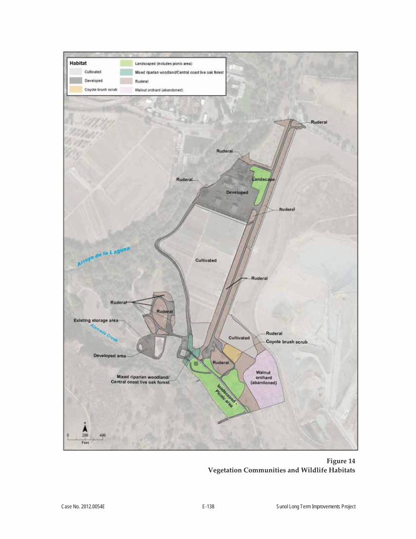
Case No. 2012.0054E E-138 Sunol Long Term Improvements Project
Figure 14
Vegetation Communities and Wildlife Habitats

Case No. 2012.0054E E-139 Sunol Long Term Improvements Project
communities. In the study area, locations mapped as ruderal occur primarily along the entrance
road (Temple Road) and in highly disturbed areas (see Figure 14).
The ruderal community is essentially an annual grassland community, consisting of a dense to
sparse cover of non-native annual grasses and forbs. This is not a sensitive community type. The
dominant non-native species in the survey area include the grasses ripgut brome (Bromus
diandrus), soft brome (B. hordeaceus), wild oats (Avena fatua, A. barbata), Italian ryegrass (Lolium
multiflorum), rattail fescue (Vulpia myuros), and rough and smooth cat’s-ear (Hypochaeris glabra,
H. radicata). In less-disturbed areas, nonnative grassland also supports a considerable variety of
native grasses and forbs. Typical native herb species in nonnative grassland include California
poppy (Eschscholzia californica), sky lupine (Lupinus nanus), and miniature lupine (L. bicolor). The
ruderal areas also support some very persistent invasive non-native herbs, such as shortpod
mustard (Hirschfeldia incana), Italian thistle (Carduus pycnocephalus), milk thistle (Silybum
marianum), mallow (Malva spp.), bur clover (Medicago polymorpha), fennel (Foeniculum vulgare),
Bermuda buttercup (Oxalis pes-caprae), English plantain (Plantago lanceolata), bristly ox-tongue
(Helminthotheca echioides), pineapple weed (Matricaria discoidea), storksbill or filarees (Erodium
ssp.), mustards (Brassica ssp.), and annual grasses.
Walnut Orchard (Abandoned). There is a small stand of walnut trees southeast of the Sunol
Water Temple. Based on a review of historic aerial photos, this stand is a remnant of a former
walnut (Juglans sp.) orchard that is no longer in production. The understory of the walnut
orchard consists of ruderal, annual grassland species. This vegetation community is not
recognized as a natural community by CDFW.175
Cultivated Agriculture. The cultivated agricultural habitat type includes areas that are typically
planted with crops including wheat, barley, and vegetables. This vegetation community is not
recognized as a natural community by CDFW.176 The two primary areas of this habitat type are in
the areas north of the Sunol Water Temple and northeast of the Sunol Water Temple adjacent to
the gravel quarry. Some of the cultivated area adjacent to the Sunol Water Temple is currently
fallow, and dominated by weeds.
175 CDFG, 2010. Hierarchical List of Natural Communities with Holland Types. September. Available online at: dfg.ca.gov/biogeodata/vegcamp/natural_comm_list.asp. Accessed September 23, 2011.
176 Ibid.

Case No. 2012.0054E E-140 Sunol Long Term Improvements Project
Coyote Brush Scrub. Coyote brush scrub is a low, dense shrub community with scattered grassy
openings. Coyote brush scrub is not a sensitive natural community.177 This natural community is
dominated by annual grassland with dispersed coyote brush (Baccharis pilularis) throughout. In
the study area, coyote brush scrub is associated with a ruderal or annual grassland understory,
and occupies a small area adjacent to an agricultural field, parking lot, and an abandoned walnut
orchard.
Mixed Riparian Woodland. Mixed riparian woodland habitat occupies slightly mesic upland
sites associated with ephemeral streams or the floodplains of larger streams in otherwise dry,
grass-dominated landscapes. The closest equivalent to mixed riparian woodland in CNDDB
classification is Central Coast Live Oak Riparian Forest, which is a sensitive natural
community.178 It typically is a low to moderately tall forest dominated—sometimes exclusively—
by coast live oak (Quercus agrifolia), with valley oak, California bay laurel, sycamore, and
California buckeye (Aesculus californica); with an open understory consisting of blue wildrye
(Elymus glaucus ssp. glaucus), coyote brush, California rose (Rosa californica), California blackberry
(Rubus ursinus), common elderberry (Sambucus nigra ssp. canadensis), California beeplant
(Scrophularia californica), and poison oak (Toxicodendron diversilobum). Native species dominate the
understory in areas outside the existing picnic area that have not been mowed.
In the project area, mixed riparian woodland is found in the upper floodplain of Alameda Creek
along the southern portion of the study area. Part of this area is maintained as a picnic area, with
similar tree species, but without the understory vegetation typical of mixed riparian woodland.
The picnic area is identified separately as part of the landscaped habitat type described above.
Mixed riparian woodland habitat in the study area transitions to ruderal, annual grassland and
disturbed habitats at higher elevations above Alameda Creek.
177 Ibid. 178 CDFG, 2010. Hierarchical List of Natural Communities with Holland Types. September. Available online at:
dfg.ca.gov/biogeodata/vegcamp/natural_comm_list.asp. Accessed September 23, 2011.

Case No. 2012.0054E E-141 Sunol Long Term Improvements Project
In the new Second Edition of A Manual of California Vegetation,179 coast live oak riparian forest
would correspond to Quercus agrifolia Woodland Alliance or coast live oak woodland, and this
vegetation community is given an S4 ranking.180
Special-Status Species
Special status species are plants and animals that are legally protected under the federal and state
Endangered Species Acts, or other regulations; and species that are considered sufficiently rare or
threatened to qualify for such listing. A list of special status plant and animal species that have
the potential to occur in the vicinity of the project area was compiled based on data described
above in Approach to Analysis. Appendix C lists special status plants and animals, their
preferred habitats, and their potential to occur in the project area, based on the results of the
reconnaissance survey; as well as an analysis of existing literature and databases described
above.
Only species with the potential to occur in the project area are listed in Appendix C, and are
further discussed in this section. Species unlikely to occur in the project area due to lack of
suitable habitat or range are not included in the discussion. No special status plant species were
observed during the botanical surveys. Because all project activities will take place in the project
footprint, and are not anticipated to affect any bodies of water, no impacts to special-status fish
would occur. Therefore, special status fish species are not included in Appendix C, and they are
eliminated from further discussion.
The following special status wildlife species were determined to have a moderate or high
potential to occur in or adjacent to the project area:
White-tailed kite (Elanus leucurus);
American peregrine falcon (Falco peregrinus anatum);
Loggerhead shrike (Lanius ludovicianus); and
San Francisco dusky-footed woodrat (Neotoma fuscipes annectens).
179 Sawyer, J., T. Keeler-Wolf, and J. Evens, 2008. A Manual of California Vegetation (Second edition), CNPS Sacramento. 1,300 pp.
180 State ranking of S4 indicates that the plant community is “apparently secure within California… but factors exist to cause some concern; i.e., there is some threat, or somewhat narrow habitat.”

Case No. 2012.0054E E-142 Sunol Long Term Improvements Project
Wetlands and Other Waters
No wetlands or other waters of the United States regulated by the U.S. Army Corps of Engineers,
or waters of the state regulated by the RWQCB or the CDFW, are in the project area.
Impact BI 1: The project could have a substantial adverse effect, either directly or through habitat modifications, on species identified as a candidate, sensitive, or special status species in local or regional plans, policies, or regulations, or by the CDFW or USFWS. (Less than Significant with Mitigation Incorporated)
During construction, the project could have potentially significant adverse impacts to three
special status species that have a moderate or high potential to occur in or adjacent to the project
area: white-tailed kite, loggerhead shrike, and San Francisco dusky-footed woodrat. Project
construction and operation would not significantly impact American peregrine falcon, because
no nesting habitat for this species is present in the project area, and the loss of foraging habitat
would be minimal compared to abundant foraging habitat available in the region.
Although the species listed above have not been observed in the project area during the site
reconnaissance surveys, habitat that may support the presence of white-tailed kite, loggerhead
shrike, and San Francisco dusky-footed woodrat species occurs adjacent to or in the project area.
White-tailed kites and woodrat stick houses were observed in the immediate vicinity of the
project area during the reconnaissance surveys; therefore, there is a moderate to high potential
for these species to occur in or adjacent to the project area during construction. Project activities
have the potential to adversely affect these species and their associated habitats through habitat
modification or disruption of nesting efforts; this would be a potentially significant impact.
White tailed kite and loggerhead shrike. White tailed kite (California Fully Protected species)
typically nest in riparian habitat, oak woodlands, or other elevated sites. This species may also
nest in rows of trees used for windbreaks. Typical foraging habitat for this species includes
woodland edges, open fields, grasslands, and open waters such as lakes or reservoirs. Portions of
the project area, including the landscaped areas near the Sunol Water Temple, are potentially
suitable for nesting white-tailed kites. Foraging habitat in the project area is very limited because
most of it is developed, landscaped, or dominated by ruderal vegetation. Adjacent annual
grassland habitat may provide some foraging habitat for white tailed kite.
The loggerhead shrike is a CDFW Species of Special Concern, and is also protected under the
Migratory Bird Treaty Act. The loggerhead shrike inhabits open lowlands and foothills. The

Case No. 2012.0054E E-143 Sunol Long Term Improvements Project
coyote brush scrub and riparian corridors along Alameda Creek and along Arroyo de la Laguna
are potentially suitable nesting habitats for loggerhead shrike.
No known nesting habitat is proposed to be modified or eliminated by the project. No suitable
nesting trees would be removed, and raptor nests were not observed in or immediately adjacent
to the project area during reconnaissance level surveys. Construction activities, especially those
that involve ground disturbance and the use of heavy machinery, could adversely affect nesting
white-tailed kites or loggerhead shrikes in the project vicinity during the nesting season (March 1
through August 31). Due to noise attenuation and screening by other trees, potential effects on
active nests of white-tailed kites would be minimal beyond 500 feet from the project area, and
effects on active nests of loggerhead shrike would be minimal beyond 150 feet of the project area.
Adverse effects such as noise and visual disturbance could affect nesting efforts, resulting in
potentially significant impacts on special status raptors and other bird species. To avoid potential
disturbance of nesting habitat, as well as impacts to future active nest sites, the following mitigation
measure is required. With implementation of Mitigation Measure M BI 1a, Nesting Bird Survey
Protection, potential impacts to special status bird species would be Less than Significant with
Mitigation Incorporated by requiring surveys to be conducted prior to the initiation of construction
to identify active nests and, if present, take appropriate measures to avoid impacts to those nests
as described below.
Mitigation Measure M-BI-1a: Nesting Bird Survey Protection
To protect nesting birds and their nests, the SFPUC shall retain a qualified wildlife
biologist to conduct pre construction surveys for nesting raptors and migratory birds
prior to the commencement of construction activities that occur between March 1 and
August 31 of any given year. The surveys shall be conducted a maximum of 14 days
prior to the start of construction during the nesting season. The project area plus a
500 foot survey area surrounding the project area shall be surveyed for nesting raptors; a
150 foot survey area in addition to the project area shall be surveyed for other nesting
birds. A nest is defined to be active for raptors and migratory birds if there is a pair of
birds displaying reproductive behavior (i.e., courting) at the nest and/or if the nest
contains eggs or chicks. If no active nests are detected, no additional mitigation measures
will be required.

Case No. 2012.0054E E-144 Sunol Long Term Improvements Project
If active nests are located during the preconstruction bird nesting survey, the wildlife
biologist shall evaluate whether the schedule of construction activities could affect the
active nest, and the following measures shall be implemented based on their
determination:
If construction is not likely to affect the active nest, it may proceed without
restriction; however, a biologist shall regularly monitor the nest to confirm there
is no adverse effect, and may revise their determination at any time during the
nesting season. In this case, the following measure would apply.
If construction may affect the active nest, the biologist shall establish a no-
disturbance buffer. The biologist shall determine the appropriate buffer, taking
into account the species involved, and whether the presence of any obstruction,
such as a building, is within line-of-sight between the nest and construction, and
the level of project and ambient activity (i.e., adjacent to a road or active trail).
No-disturbance buffers for passerines typically vary from 25 feet to 250 feet, and
for raptors from 300 feet to 0.25 mile. For bird species that are federally and/or
state-listed sensitive species (i.e., threatened, endangered, fully protected, or
species of special concern), an SFPUC representative, supported by the wildlife
biologist, shall consult with the USFWS and/or CDFW regarding appropriate
nest buffers.
Removing inactive passerine nests may occur at any time. Inactive raptor nests
shall not be removed unless approved by the USFWS and/or CDFW.
Removing or relocating active nests shall be coordinated by the SFPUC
representative with the USFWS and/or CDFW, as appropriate, given the nests
that are found on the site.
Any birds that begin nesting in the project area and survey buffers during
construction are assumed to be habituated to construction-related or similar
noise and disturbance levels, and no work exclusion zones shall be required.
San Francisco dusky-footed woodrat. The San Francisco dusky-footed woodrat (CDFW Species
of Special Concern) typically occupy woodlands and riparian forest dominated by live oaks and

Case No. 2012.0054E E-145 Sunol Long Term Improvements Project
other thick-leaved trees and shrubs.181 Woodrat stick houses were observed in the project vicinity.
Although no woodrat stick houses were observed in the area that is proposed to be developed or
disturbed by the project, stick houses could become established in the project area prior to the
start of construction. Construction activities, especially those that involve ground disturbance
and the use of heavy machinery, could adversely affect woodrats if stick houses are within 15 feet
of the disturbance, resulting in potentially significant impacts on this species of special concern.
To avoid potential disturbance of woodrat stick houses, the following mitigation measure is
required. With implementation of Mitigation Measure M-BI 1b, Preconstruction Survey for San
Francisco Dusky-Footed Woodrat, potential impacts to San Francisco dusky-footed woodrat
would be Less than Significant with Mitigation Incorporated by requiring surveys to be conducted
prior to construction to identify active nests and if present, take appropriate measures to avoid
impacts to those nests as described below.
Mitigation Measure M-BI 1b: Preconstruction Survey for San Francisco Dusky-Footed Woodrat
The SFPUC shall ensure that a qualified biologist conducts a survey for woodrat middens
(i.e., nests) within all limits of construction prior to the initiation of clearing or grading in
any given location. When feasible, surveys for woodrat nests shall start 1 month prior to
site clearing so that any middens requiring removal can be addressed before
construction.
If no middens are found in such areas, no further action is required.
If middens are found and can be avoided, the biologist shall direct the contractor
in placing orange barrier fencing at least 2 feet but not more than 15 feet from the
midden to avoid indirect disturbance to the midden.
If the minimum fencing distance cannot be achieved and the middens cannot be
protected and/or avoided, a qualified biologist shall disassemble middens; or, if
adjacent habitat is not suitable, trap and relocate woodrats out of the
construction area (using live-traps) prior to the start of construction. In addition,
the biologists shall attempt to relocate the disassembled midden to the same area
where the woodrats are released. If young are present during disassembling,
181 Williams, D.F., J. Verner, H.F. Sakai, and J.R. Waters, 1992. General biology of major prey species of the California spotted owl. USDA Forest Service Gen. Tech. Rep., PSW-GTR-133:207-221.

Case No. 2012.0054E E-146 Sunol Long Term Improvements Project
discontinue disassembling and inspect every 48 hours until young have
relocated. The midden may not be fully disassembled until the young have left.
Impact BI 2: The project would not have a substantial adverse effect on riparian habitat or other sensitive natural community identified in local or regional plans, policies, regulations or by the CDFW or USFWS. (No Impact)
The project does not involve activities that would encroach on riparian habitat or other sensitive
natural communities identified in local or regional plans, policies, regulations, or by the CDFW or
USFWS.
Impact BI 3: The project would not have a substantial adverse effect on federally protected wetlands as defined by Section 404 of the Clean Water Act. (No Impact)
The project construction activities would not encroach on wetlands or other waters of the United
States. No removal, filling, hydrological interruption, or other direct impacts to federal or state-
regulated wetlands or other waters are anticipated.
Impact BI-4: The project would not interfere substantially with the movement of any native resident or migratory fish or wildlife species or with established native resident or migratory wildlife corridors, or impede the use of native wildlife nursery sites. (No Impact)
The project construction would be located in developed, landscaped, and ruderal areas that do
not provide substantial movement or migration opportunities for resident or migratory wildlife
in the region. Although the project area borders woodlands associated with Alameda Creek and
Arroyo de la Laguna, the project area would not encroach into these habitats, and would not
substantially change existing noise or lighting that could adversely affect the movement of
wildlife.
Impact BI-5: The project does not conflict with any local policies or ordinances protecting biological resources, such as a tree preservation policy or ordinance. (No Impact)
No local policies or ordinances are established that protect biological resources in the project
area. Therefore, the project would not conflict with local policies or ordinances relevant to
biological resources.
Impact BI-6: The project does not conflict with the provisions of an adopted Habitat Conservation Plan, Natural Community Conservation Plan, or other approved local, regional, or state habitat conservation plan. (No Impact)
There are no approved Habitat Conservation Plans or Natural Community Conservation Plans
for the region that includes the proposed project area.
Case No. 2012.0054E E-147 Sunol Long Term Improvements Project
Impact C-BI: The proposed project, in combination with past, present, and reasonably foreseeable future projects in the vicinity of the project area, could result in significant cumulative impacts on biological resources. (Less than Significant with Mitigation Incorporated)
The geographic scope of cumulative biological resources impacts encompasses the proposed
project site and nearby vicinities which contain the same types of biological resources. Other
projects in the Sunol Valley considered in the cumulative analysis, such as the SABPL Project, the
NIT Project, the San Antonio Pump Station Upgrade, Calaveras Dam Replacement Project, and
the Geary Road Bridge Replacement Project (described in Table 9) affect similar biological
resources as the proposed project and occur within the general vicinity of the proposed project.
These projects have the potential to disturb nesting bird species and dusky-footed woodrat stick
houses similar to those affected by the proposed project. Together, the proposed project and
other cumulative projects in the vicinity could have a significant cumulative impact on these
special-status species.
The contribution of the proposed project to cumulative biological resources impacts could be
cumulatively considerable, given its potential to also result in significant impacts on these
special-status species. However, implementation of Mitigation Measures M-BI-1a, Nesting Bird
Survey Protection and M-BI-1b, Preconstruction Survey for San Francisco Dusky-Footed
Woodrat, would avoid or substantially minimize the proposed project’s effect on special-status
species. As a result, these measures would reduce the project’s contribution to cumulative
impacts on biological resources to a less-than-cumulatively considerable level with the above listed
mitigations incorporated into the project (Less than Significant with Mitigation Incorporated).

Case No. 2012.0054E E-148 Sunol Long Term Improvements Project
Topics:
Potentially Significant
Impact
Less than Significant
with Mitigation
Incorporated
Less-than- Significant
Impact No
Impact Not
Applicable
E.14 GEOLOGY AND SOILS— Would the project:
a) Expose people or structures to potential substantial adverse effects, including the risk of loss, injury, or death involving:
i) Rupture of a known earthquake fault, as delineated on the most recent Alquist-Priolo Earthquake Fault Zoning Map issued by the State Geologist for the area or based on other substantial evidence of a known fault? (Refer to Division of Mines and Geology Special Publication 42.)
ii) Strong seismic ground shaking?
iii) Seismic-related ground failure, including liquefaction?
iv) Landslides?
b) Result in substantial soil erosion or the loss of topsoil?
c) Be located on geologic unit or soil that is unstable, or that would become unstable as a result of the project, and potentially result in on- or off-site landslide, lateral spreading, subsidence, liquefaction, or collapse?
d) Be located on expansive soil, as defined in Table 18-1-B of the Uniform Building Code, creating substantial risks to life or property?
e) Have soils incapable of adequately supporting the use of septic tanks or alternative wastewater disposal systems where sewers are not available for the disposal of wastewater?
f) Change substantially the topography or any unique geologic or physical features of the site?
There are no unique geologic or physical features at the project sites, and project grading would
not substantially change the existing topography. For these reasons, significance criterion 14f is
considered not applicable to the project, and is not discussed further.
Case No. 2012.0054E E-149 Sunol Long Term Improvements Project
Impact GE-1: The project would not expose people or structures to potential substantial adverse effects, including the risk of loss, injury, or death involving rupture of a known earthquake fault, strong seismic ground shaking, seismic-related ground failure, or landslides. (Less than Significant)
Fault Rupture
The major active faults in the area are the Calaveras, Hayward, and San Andreas faults.
Historically, ground-surface ruptures closely follow the trace of geologically young faults.
Although the Calaveras fault is within 1 mile of the site, the site is not in an Earthquake Fault
Zone, as defined by the Alquist-Priolo Earthquake Fault Zoning Act of 1972, and no known active
or potentially active faults exist on the site. Therefore, the risk of fault offset at the site from a
known active fault is very low and the impact from the rupture of a known earthquake fault
would be Less than Significant.
Ground Shaking
During a major earthquake on a segment of one of the nearby faults, strong to very strong
shaking is expected to occur at the project site. The intensity of the earthquake ground motion at
the site will depend on the characteristics of the generating fault, distance to the earthquake
epicenter, magnitude and duration of the earthquake, and specific site geologic conditions.
Strong shaking during an earthquake can result in ground failure such as that associated with
soil liquefaction and lateral spreading. In most earthquakes, only weaker masonry buildings
would be damaged.
The SFPUC seismic reliability standards set forth consistent criteria for the seismic design and
retrofit of all facilities and components of the regional water system. 182 In accordance with these
design requirements, every project must have project-specific design criteria based on the seismic
environment and importance of the facility in achieving water service delivery goals in the event
of a major earthquake. The design criteria are generally based on the referenced codes, standards,
and industry publications; however, in some cases, design criteria may exceed these
requirements for facilities, such as the project sites that are in a severe seismic environment and
that are needed to achieve water service delivery goals. Site-specific geotechnical investigations
182 SFPUC, 2014. General Seismic Requirements for Design of New Facilities and Upgrade of Existing Facilities. Revision 3, DOC No. WSIP/CSP 001 R2R3. June.

Case No. 2012.0054E E-150 Sunol Long Term Improvements Project
were performed for both the Sunol Yard and the proposed Watershed Center.183,184 Specific
seismic design criteria were recommended based on these investigations.
Because the project would be evaluated and designed according to the SFPUC seismic reliability
standards to avoid unacceptable system failure, the impact of strong seismic ground shaking
would be Less than Significant.
Ground Failure and Liquefaction
Liquefaction is a phenomenon whereby soil deposits temporarily lose shear strength and
collapse. The soil type most susceptible to liquefaction is loose, cohesionless, granular soil below
the water table and within about 50 feet of the ground surface. Liquefaction can result in a loss of
foundation support and settlement of overlying structures, ground subsidence, and translation
due to lateral spreading, lurch cracking, and differential settlement of affected deposits. Lateral
spreading occurs when a soil layer liquefies at depth and causes horizontal movement or
displacement of the overlying mass on sloping ground or towards a free face such as a stream
bank or excavation.
The proposed Watershed Center would be constructed on Holocene stream terrace deposits,
which are classified by Bott and Knudsen185 as having very low, low, medium, or high
liquefaction susceptibility, depending on the depth of the water table. Based on the site-specific
information from the current investigation, the potential liquefiable material generally lies at
depths shallower than 18 feet. The water table is estimated to be between 20 and 30 feet bgs,
although it may be shallower during winter months. Therefore, the liquefaction potential is
generally low at the site.
Because the risk of liquefaction at the site is considered to be low, the risk to the proposed
structures from lateral spreading at the site is also low. However, the risk from lateral spreading
183 San Francisco Department of Public Works Bureau of Engineering, 2011. Geotechnical Report for Sunol Maintenance Yard and Water Temple. Prepared for the San Francisco Public Utilities Commission. July.
184 URS, 2012. Geotechnical Investigation Report for the Proposed Watershed Interpretative Center, Sunol, California. Prepared for San Francisco Public Utilities Commission. December.
185 Bott, J.D.J., and K.L. Knudsen, 2004. Liquefaction Zones of required investigation in the Niles 7.5-minute Quadrangle, Alameda County, California. Seismic hazard zone report for the Niles 7.5-minute quadrangle, Alameda County, California, California Geological Survey Seismic Hazard Zone Report 098.

Case No. 2012.0054E E-151 Sunol Long Term Improvements Project
can be expected to be higher closer to the scarp that marks the northeastern bank of Alameda
Creek.
Because the project would be evaluated and designed according to the SFPUC seismic reliability
standards, as discussed above under criterion a)ii), the impact of seismic-related ground failure,
including liquefaction, would also be Less than Significant.
Landslides
The project site is in an area of low landslide hazard, due to the lack of steep slopes in or adjacent
to the project site. The California Geological Survey186 has developed a map depicting the relative
likelihood of deep landsliding based on regional estimates of rock strength and steepness of
slopes. The Sunol Valley is not considered susceptible to landslides due to the flatness of the
valley floor.187 Therefore, due to the lack of slopes susceptible to landslides, there would be No
Impact with respect to landslides at these project sites.
Impact GE-2: The project would not result in substantial soil erosion or the loss of topsoil. (Less than Significant)
Project construction activities have the potential to result in increased soil erosion or loss of
topsoil due to ground disturbance associated with excavation, minor grading, and material
staging areas. The SFPUC has standard measures it includes in construction contracts that require
the implementation of erosion and sedimentation controls tailored to the site and the project, to
minimize impacts associated with wind and water erosion.188 Given the erosion control measures
that would be implemented during construction as part of the project, impacts associated with
soil erosion would be Less than Significant. Sites would be restored following construction, and no
ground-disturbing activities would be associated with project operation, so no soil erosion is
expected to occur during project operation and maintenance. For these reasons, the impact of
construction, operation, and maintenance of the project on accelerated soil erosion would be Less
than Significant.
186 California Geological Survey, 2011. Susceptibility to Deep-Seated Landslides in California. Prepared by C.J. Wills, F.G. Perez, and C.I. Gutierrez. California Geological Survey Map Sheet 58.
187 Ibid. 188 SFPUC, 2007. Standard Measures to be Included in Construction Contracts and Project Implementation.
February 7.

Case No. 2012.0054E E-152 Sunol Long Term Improvements Project
Impact GE-3: The project could be located on a geologic unit or soil that is unstable, or that would become unstable as a result of the project, and could result in onsite or offsite landslide, lateral spreading, subsidence, liquefaction, or collapse. (Less than Significant)
As discussed under Impact GE-1, the project site is in an area not prone to landslides, on
Holocene stream terrace deposits, which are classified by Bott and Knudsen as having very low,
low, medium, or high liquefaction susceptibility depending on the depth of the water table.189
Based on the site-specific information, the potential liquefiable material generally lies at depths
shallower than 18 feet. The water table is estimated to be between 20 and 30 feet bgs, although it
may be shallower during winter months. Therefore, the liquefaction potential is generally low at
the site. Because the risk of liquefaction at the site is low, the risk to the proposed structures from
lateral spreading at the site is also low. However, the risk from lateral spreading can be expected
to be higher closer to the scarp that marks the northeastern bank of Alameda Creek.
Structures at the project site would be designed according to basic guidelines of the California
Building Code (CBC), and the SFPUC seismic reliability standards, which are equivalent to or
more stringent than the seismic design requirements of the CBC. In addition, the SFPUC includes
standard measures in construction contracts to incorporate review of existing information, and if
necessary, new engineering investigations to provide relevant geotechnical information about the
particular site and project, including a characterization of the soils at the site, and the potential
for subsidence and other ground failure. As a result, the construction contractor would be
required to address any recommendations by such geotechnical reports to ensure seismic
stability and reliability of the proposed project. All SFPUC projects must be designed for seismic
reliability and minimum potential property damage. Therefore, the impact of construction,
operation, and maintenance of the project would be Less than Significant.
Impact GE-4: Project structures could be located on expansive soil, as defined in Table 18-1-B of the Uniform Building Code, creating substantial risks to life or property. (Less than Significant)
Expansive soils are those that shrink or swell significantly with changes in moisture content. The
clay content and porosity of the soil also influence its volume change characteristics, and higher
plasticity index correlates to higher expansion potential. The shrinking and swelling caused by
189 Bott, J.D.J., and K.L. Knudsen, 2004. Liquefaction Zones of required investigation in the Niles 7.5-minute Quadrangle, Alameda County, California. Seismic hazard zone report for the Niles 7.5-minute quadrangle, Alameda County, California, California Geological Survey Seismic Hazard Zone Report 098.

Case No. 2012.0054E E-153 Sunol Long Term Improvements Project
expansive clay-rich soils often results in damage to overlying structures. The site is generally
underlain by low -plasticity silty sand. Therefore, the potential for expansive soil to impact the
proposed improvements would be low, and this impact would therefore be Less than Significant.
Impact GE-5: The project site could have soils incapable of adequately supporting the use of septic tanks or alternative wastewater disposal systems where sewers are not available for the disposal of wastewater. (Less than Significant)
Consistent with baseline conditions at the site, the project would include installation of
underground wastewater holding tanks. These tanks would be pumped, and waste would be
transported for treatment at an offsite wastewater treatment plant. Therefore, no infiltration of
wastewater would occur to the surrounding soils. As a result, the project impact regarding soils
incapable of adequately supporting the use of septic tanks or alternative wastewater disposal
systems would be Less than Significant.
Impact C-GE: The proposed project, in combination with past, present, and reasonably foreseeable future projects in the vicinity, would not have a significant cumulative impact on geology and soils. (Less than Significant)
The geographic scope for the analysis of potential cumulative impacts relative to geology, soils,
and seismicity is limited to the project site because the potential for hazards related to seismically
induced ground failure, erosion or loss of topsoil, soil subsidence, collapsible soils, and expansive
soils are based on local site-specific soil and geologic conditions.
Therefore, because none of the other identified cumulative projects in Table 9 would be
developed at the same site as the proposed project, cumulative geologic and soils impacts would
be Less than Significant.

Case No. 2012.0054E E-154 Sunol Long Term Improvements Project
Topics:
Potentially Significant
Impact
Less than Significant
with Mitigation
Incorporated
Less-than- Significant
Impact No
Impact Not
Applicable
E.15 HYDROLOGY AND WATER QUALITY— Would the project:
a) Violate any water quality standards or waste discharge requirements?
b) Substantially deplete groundwater supplies or interfere substantially with groundwater recharge such that there would be a net deficit in aquifer volume or a lowering of the local groundwater table level (e.g., the production rate of pre-existing nearby wells would drop to a level which would not support existing land uses or planned uses for which permits have been granted)?
c) Substantially alter the existing drainage pattern of the site or area, including through the alteration of the course of a stream or river, in a manner that would result in substantial erosion of siltation on- or off-site?
d) Substantially alter the existing drainage pattern of the site or area, including through the alteration of the course of a stream or river, or substantially increase the rate or amount of surface runoff in a manner that would result in flooding on- or off-site?
e) Create or contribute runoff water which would exceed the capacity of existing or planned stormwater drainage systems or provide substantial additional sources of polluted runoff?
f) Otherwise substantially degrade water quality?
g) Place housing within a 100-year flood hazard area as mapped on a federal Flood Hazard Boundary or Flood Insurance Rate Map or other authoritative flood hazard delineation map?
h) Place within a 100-year flood hazard area structures that would impede or redirect flood flows?
i) Expose people or structures to a significant risk of loss, injury or death involving flooding, including flooding as a result of the failure of a levee or dam?
j) Expose people or structures to a significant risk of loss, injury or death involving inundation by seiche, tsunami, or mudflow?

Case No. 2012.0054E E-155 Sunol Long Term Improvements Project
The proposed project does not involve the construction of any housing; therefore, significance
criterion g) does not apply.
Impact HY-1: The project would not violate any water quality standards or waste discharge requirements. (Less than Significant)
Construction
Potential impacts to water quality resulting from the project would occur primarily as a result of
ground-disturbing activities during construction at each of the project sites. The project is
adjacent to Arroyo de la Laguna and Alameda Creek (see Figure 2). Site preparation, demolition,
clearing, grading, excavation, soil stockpiling, backfilling, compacting, site restoration, and
landscaping activities would occur for each project site, as shown in Tables 3 and 4. The project
would use concrete and concrete washout water, which if released into waterways, would be
toxic to fish and aquatic organisms due to its high pH and metal constituents. These construction
activities have the potential to adversely affect the quality of nearby surface waters if stormwater
runoff or groundwater dewatering discharges from the sites contain elevated levels of suspended
sediment, turbidity, toxins, or other chemicals (e.g., due to presence of exposed soils, soil
stockpiles, material staging areas, fuels, or chemicals associated with vehicles and construction
equipment).
Stormwater Discharges Associated with Construction
Construction activities at each project site would disturb more than 1 acre of ground surface. For
the Sunol Yard, ground-disturbing activities would occur in the 8-acre northern portion of the
project site. For the Watershed Center, ground-disturbing activities would occur over most of the
8-acre site. Activities scheduled to be constructed during the rainy season (October through
April), as shown in Tables 2 and 3, would have a greater potential to contribute to water quality
impacts than those constructed during the dry season.
The extension of water, natural gas, and communication utilities from the Sunol Yard to the new
Watershed Center would be buried in shallow trenches along the eastern side of Temple Road.
The electrical transmission line would be placed underground between the Sunol Pump Station
and the Watershed Center.
In addition, a supplementary construction staging area currently used as a materials storage area
would be used for the project. Equipment and materials that would be stored include
construction vehicles, construction materials, stockpiled soil, and small quantities of fuels and
Case No. 2012.0054E E-156 Sunol Long Term Improvements Project
lubricants. As stated in Section A.5.4 Construction Staging Areas, above, once the staging area is
no longer needed, it would be restored to its general previous, preconstruction condition.
There would be no construction activities in Alameda Creek or Arroyo de la Laguna. As
recommended by the RWQCB,190 construction stockpiles and material storage areas would be a
minimum distance of 100 feet away from the creeks, wherever possible. The buffer width needed
to maintain water quality generally ranges from approximately 15 to 100 feet.191,192 For a
discussion related to the filter galleries that capture subsurface water near Alameda Creek and
return it to the water supply system, see Impact HY-2, below. In addition to the required
setbacks, BMPs would be developed pursuant to the Construction General Permit requirements
and would be implemented to prevent the discharge of pollutants into the creeks. Typical
construction water quality BMPs, such as the SFPUC Standard Construction Measures and
industry standard measures, as described in Section A.5.8, Standard Construction Measures, are
proposed as part of the project. Implementation of these BMPs would control and reduce
discharges of sediments and pollutants associated with construction stormwater runoff that
could discharge to creeks, and thereby minimize the potential for temporary construction-related
water quality impacts.
The project would disturb more than 1 acre; therefore, the SFPUC would be required to obtain
coverage under the State Water Resources Control Board’s (SWRCB’s) Construction General
Permit, as detailed in Section A.7, Required Actions and Approvals. Construction activities
subject to this permit include, but are not limited to, clearing, grading, stockpiling, and
excavation. Among other provisions, the Construction General Permit requires the development
and implementation of a SWPPP, which would include and specify BMPs designed to prevent
pollutants from contacting stormwater, and keep all products of erosion from moving off site into
receiving waters. The SFPUC or its contractor would submit permit registration documents to the
San Francisco RWQCB, which would include a Notice of Intent, a risk assessment, a site map, a
SWPPP, an annual fee, and a signed certification statement. The risk assessment would determine
190 RWQCB, 2012. Comments on Initial Study for the Geary Road Bridge Replacement Project SCH No. 2008.0386E.
191 Caltrans, 2003. Storm Water Quality Handbooks: Construction Site Best Management Practices (BMPs) Manual.
192 CASQA, 2009. Stormwater Best Management Practice Handbook Portal: Construction.

Case No. 2012.0054E E-157 Sunol Long Term Improvements Project
which provisions of the Construction General Permit (e.g., numeric action levels and effluent
limitations for pH and turbidity, rain event action plans, and monitoring and reporting
requirements) would apply, based on a combination of sediment risk and receiving water risk at
each site. The SWPPP would include a list of BMPs necessary to prevent stormwater runoff from
the construction site from adversely affecting nearby water bodies, and would include the
information necessary to support the conclusions, selections, use, and maintenance of BMPs.
As part of the LEED Gold certification requirement for municipal construction projects (San
Francisco Environment Code, Chapter 7), the LEED Project Administrator must submit
documentation verifying that construction of City-owned buildings greater than 5,000 square feet
achieve the LEED SS6.2 credit.193 This credit addresses the prevention of polluted runoff during
and after construction, and uses TSS as the indicator of level of pollution. Projects can use
biological or mechanical treatment methods for smaller and more frequent storms for credit
compliance. To earn the credit, the project must be able to show that the stormwater treatment
system is effective at treating all rainstorms for any year up to 90 percent of the average annual
rainfall. In addition, as part of the LEED Gold certification, the project must develop and
implement construction activity pollution prevention and stormwater management controls
adopted by the SFPUC, and comply with the Construction General Permit (LEED
prerequisite SSp1).
Compliance with the Construction General Permit (which satisfies LEED prerequisite SSp1),
preparation of a SWPPP, and implementation of BMPs would reduce potential construction
impacts related to erosion, runoff, and water quality degradation to Less than Significant levels.
Temporary Dewatering Discharges
Excavations for building foundations, wastewater holding tanks, and ancillary components such
as water, natural gas, and communication utilities could require temporary dewatering if
groundwater or stormwater were to accumulate in the excavated pits during the construction
phase.
193 CCSF, 2011. San Francisco Environment Code, Chapter 7, Green Building Requirements for City Buildings.

Case No. 2012.0054E E-158 Sunol Long Term Improvements Project
The depth of excavation for removal of existing wastewater holding and fuel storage tanks, the
building foundations, and installation of wastewater holding tanks would range between 5 feet
and 15 feet bgs. Excavation for the utility corridors would be shallow, typically less than 6 feet.
Based on a previous subsurface investigation conducted at the project site in June 2012,
groundwater is expected to be encountered at a depth of approximately 20 to 30 feet bgs.194
Groundwater was not encountered in any of the borings drilled to a maximum depth of 36.5 feet,
but the water table was inferred from field examination of the soil in the borings. The depth to
groundwater is also expected to vary seasonally, and depend on the flow level in the adjacent
creeks.195
Based on the approximate elevation and depth of groundwater estimated during previous nearby
geotechnical investigations and the anticipated excavation depths, substantial quantities of
groundwater requiring dewatering would not be anticipated for most of the project facilities,
because the expected maximum depth of excavation is less than the estimated depth to
groundwater. Excavation for the wastewater holding tank is most likely to encounter
groundwater. However, actual groundwater elevations at the sites are not well known, and may
fluctuate depending on the flows in the adjacent creeks, time of the year (e.g., summer versus
winter), and type of year (e.g., dry versus wet), as well as site-specific conditions. Groundwater
extracted during construction of the project, if any, would be temporary and localized, and any
effects from the lowering of groundwater levels or depletion of groundwater resources would be
temporary, because once construction was completed, dewatering would cease.
Because the sites are in close proximity to surface water bodies, it is possible that dewatering
discharges, if uncontrolled, could eventually reach nearby surface waters.
The Construction General Permit (discussed above) allows for non-stormwater discharges,
including uncontaminated groundwater from dewatering, provided that BMPs are implemented
to prevent or reduce the contact of the non-stormwater discharge with construction materials or
equipment; the discharge does not cause or contribute to a violation of any water quality
194 URS, 2012. Geotechnical Investigation Report, Sunol Yard Improvement Project – Watershed Interpretive Center. Prepared for San Francisco Public Utilities Commission. December.
195 Alameda County Planning, 2012. SMP-30 Revised Use Permit Sunol Valley Aggregate Quarry Project Draft Environmental Impact Report. SCH No. 2011102051. Prepared by Lamphier-Gregory. April.

Case No. 2012.0054E E-159 Sunol Long Term Improvements Project
standard; the discharge does not contain toxic constituents in toxic amounts or (other) significant
quantities of pollutants; and the discharge is monitored and meets the applicable Numeric Action
Levels for pH and turbidity.
With implementation of BMPs in compliance with the Construction General Permit, potential
water quality impacts related to groundwater dewatering discharges, if needed, would be Less
than Significant.
Operation
The proposed project would increase the overall amount of impervious surface by more than
32,000 square feet (i.e., due to new structures, new access roads, and new parking areas), thereby
increasing runoff from most of the site. Following construction of the proposed project, the water
quality of stormwater runoff would be expected to decline because more potential pollutants
could be generated by human activities (e.g., vehicle washing, material handling and storage, fuel
storage, waste storage) and could come into contact with stormwater or be discharged to
groundwater or the nearby creeks. Due to the proposed increase in impervious surfaces,
pollutants would tend to be flushed from impervious surfaces where they accumulate (e.g.,
paving and roofs) into stormwater management conveyances. Stormwater runoff from roads and
the parking areas would be expected to contain oils, grease, and debris. New stormwater
management facilities would be installed, and would include infiltration trenches, catch basins,
and swales. As stated in Section A.4.1, Sunol Corporation Yard Improvements and
Section A.4.2, Development of Alameda Creek Watershed Center, landscaped areas would be
incorporated into the parking lot and road designs to facilitate rainwater infiltration. As
discussed in Section A.5.1, Facilities, the stormwater system would be designed to achieve the
LEED SS6.2 credit. The goal of the proposed project is to integrate BMPs throughout the project
development to provide source control and water quality treatment of runoff from paved and
other developed areas prior to discharge into the swales and infiltration trenches that percolate
flows to groundwater and discharge into Alameda Creek and Arroyo de la Laguna (see
Section A.4.1, Sunol Corporation Yard Improvements and Section A.5.8, Standard
Construction Measures, above).
Operation and maintenance of the project could result in long-term impacts to water quality due
to increased impervious surfaces (buildings and pavement) and pollutants (cleaning agents, fuel,
wastewater holding tanks) that could come into contact with stormwater or be discharged to
Case No. 2012.0054E E-160 Sunol Long Term Improvements Project
groundwater or nearby creeks. However, as required by the Construction General Permit, the
project would comply with post-construction stormwater requirements. Stormwater drainage
improvements would provide a benefit over existing conditions. Covered parking and storage for
SFPUC equipment and vehicles would replace current open-air storage. Removal and
replacement of certain facilities, such as abandonment of existing restroom facilities in the picnic
area adjacent to Alameda Creek, removal of existing portable bathrooms at the Sunol Water
Temple, and installation of new underground wastewater holding tanks, would also provide
benefits with respect to water quality, given that the existing bathrooms are within the
floodplain.
The San Francisco Bay Municipal Regional Stormwater Permit (MRP) (RWQCB Order
R2-2009-0074; NPDES Permit No. CAS612008), which covers Alameda County, incorporates
updated state and federal requirements related to the quantity and quality of post-construction
stormwater discharges from development projects. Specifically, Provision C.3 sets forth
appropriate source control, site design, and stormwater treatment measures for new
development and redevelopment projects that create and/or replace 10,000 square feet or more of
impervious surface area. Stormwater runoff from the project site discharges directly into
Alameda Creek and Arroyo de la Laguna. Neither of these creeks is designated as a Clean Water
Act Section 303(d)-listed water body.
In general, the types of operational activities that would result from the proposed project would
be approximately the same as existing conditions. At the Sunol Yard, operation and maintenance
activities include, and would continue to include, carpentry, plumbing, welding, painting and
electrical work, automotive repair, vehicle fueling, and washing. Potential pollutants at the Sunol
Yard could include cleaning agents, paint, fuel, hydraulic fluid, and oil. It is reasonable to assume
that these materials would be properly used and stored to prevent spills and discharge to
stormwater. The vehicle wash-down area would include a drainage trench and hose bibs. The
existing vehicle fuel station would be relocated, and the exiting underground fuel tanks would be
replaced with new above-ground fuel tanks (see Section A.4.1, Sunol Corporation Yard
Improvements, above). The project would implement BMPs—described above and in
Section A.5.8, Standard Construction Measures—during operations, to prevent the discharge of
pollutants into stormwater.
As previously stated in Section A.4.1, Sunol Corporation Yard Improvements and Section A.4.2,
Development of Alameda Creek Watershed Center above, the improvements at the Sunol Yard

Case No. 2012.0054E E-161 Sunol Long Term Improvements Project
and Watershed Center would include low-flow technology and fixtures to conserve water. The
abandoned toilet facilities in the picnic area near Alameda Creek would be demolished and
removed, along with existing portable bathrooms at the Sunol Water Temple. The new sanitary
waste collection system would consist of new underground wastewater holding tanks. The
wastewater holding tanks would be designed in accordance with all applicable codes and
regulations, including required setbacks from the creeks.
As stated in Section A.4.1, Sunol Corporation Yard Improvements above, the project would
include installation of underground wastewater holding tanks. However, these tanks would be
pumped, and the wastewater would be transported for treatment at an offsite wastewater
treatment plant. Therefore, no infiltration of wastewater would occur to the groundwater in the
area.
Alameda WMP Policy WA1 prohibits the use of septic systems on SFPUC lands, while
Policy WA7 states that construction of new waste disposal systems on SFPUC lands should be
limited to those that are essential. Currently, there is no connection to a municipal sanitary
system; therefore, the proposed project must construct an onsite wastewater disposal system.
Because the wastewater holding tanks would be pumped, and the wastewater transported to an
offsite wastewater treatment plant, the project would be consistent with Policies WA1J and WA7.
Additionally, the project would be constructed at an existing SFPUC facility that is managed in
accordance with the Alameda WMP. Therefore, the project would be managed in a similar
fashion and would not conflict with the Alameda WMP.
As discussed in Section A.4.1, Sunol Corporation Yard Improvements and Section A.4.2,
Development of Alameda Creek Watershed Center, the project would include improvements to
prevent the discharge of pollutants into stormwater and the creeks. With these improvements,
compliance with stormwater requirements of the SWRCB Construction General Permit, and the
project’s goal to achieve LEED Gold Certification, operation-related impacts to water quality
would be Less than Significant.
Impact HY-2: The project would not substantially deplete groundwater supplies or interfere substantially with groundwater recharge to the extent that there would be a net deficit in aquifer volume or a lowering of the local groundwater table level. (Less than Significant)
The existing Sunol Water Temple is adjacent to the lower infiltration gallery of the Sunol Filter
Galleries. The filter galleries capture subsurface groundwater near Alameda Creek in a system of

Case No. 2012.0054E E-162 Sunol Long Term Improvements Project
pipes and tunnels built into the surrounding gravels prior to use in the SFPUC Regional Water
System.
The new Watershed Center would be constructed immediately north of the lower infiltration
gallery as shown on Figure 5 in Section A, Project Description. During construction, the project
would implement BMPs to ensure that pollutants are not introduced into the aquifer and
galleries (see Section A.5.8, Standard Construction Measures). The new Watershed Center
would be approximately 150 feet north from the galleries, and therefore, would not impede the
collection of flow from Alameda Creek (see Figure 5). The area between the new Watershed
Center and the galleries would be maintained as an open meadow-type area that would facilitate
infiltration of stormwater runoff and recharge of groundwater. The proposed riparian pond near
the Watershed Center (see Figure 5) would be lined; therefore, there would be no percolation to
groundwater or to the filter gallery. The project also would include vegetated swales and
infiltration basins to facilitate percolation to groundwater (see Section A.4.1, Sunol Corporation
Yard Improvements). As a result, the proposed project would not interfere substantially with
groundwater recharge to the extent that there would be a net deficit in aquifer volume, or a
lowering of the local groundwater table level.
Furthermore, the project would not construct any wells, nor would it pump or extract
groundwater in any way. As a result, the proposed project would not substantially deplete
groundwater supplies to the extent that there would be a net deficit in aquifer volume or a
lowering of the local groundwater table level.
By designing the project to avoid the Sunol Filter Galleries and implementing BMPs, the
proposed project would not have any adverse effects on groundwater supplies, quality, or
recharge; therefore, impacts with respect to the supply of ground water resources would be Less
than Significant.
Impact HY-3: The project would not substantially alter the existing drainage pattern of the site or area, including through the alteration of the course of a stream or river, in a manner that would result in substantial erosion or siltation onsite or offsite. (Less than Significant)
The project would not result in a substantial alteration of topography or alteration of drainage
patterns. Site preparation would involve minor leveling and grading at the Sunol Yard and
Watershed Center sites, where necessary. There would be no construction in creeks or in
undeveloped areas adjacent to creeks. As discussed in Section A.5.8, Standard Construction

Case No. 2012.0054E E-163 Sunol Long Term Improvements Project
Measures, the project would implement BMPs during construction to minimize erosion, and
prevent the discharge of sediment offsite. Therefore, any impacts related to drainage causing
erosion or siltation would be Less than Significant.
Impact HY-4: The project would not substantially alter the existing drainage pattern of the site or area, including through the alteration of the course of a stream or river, or substantially increase the rate or amount of surface runoff in a manner that would result in flooding onsite or offsite. (Less than Significant)
As discussed under Impact HY-3, the project would not result in substantial alteration of
topography or alteration of drainage patterns. In accordance with the Construction General
Permit’s post-construction runoff reduction requirements, the project would be required by
regulation to incorporate a variety of means to capture, control, detain, and ultimately release
stormwater in an amount and at a rate no greater than the amounts and rates of stormwater
runoff in the project site’s existing condition. For these reasons, any resulting potential impacts
for flooding effects from altered drainage patterns would be Less than Significant.
Impact HY-5: The project would not create or contribute runoff water that would exceed the capacity of existing or planned stormwater drainage systems, cause flooding on and off site, or provide substantial additional sources of polluted runoff. (Less than Significant)
The project site is not served by a stormwater drainage system; therefore, this element of the
impact criterion is not applicable to the project.
As discussed in Section A.4.1, Sunol Corporation Yard Improvements and Section A.4.2,
Development of Alameda Creek Watershed Center, the project would install a new stormwater
drainage system would be designed to facilitate infiltration and reduce the potential increase in
stormwater runoff that could cause flooding on or off site. As stated in Section A.7, Required
Actions and Approvals above, the project would be required to comply with State Water
Resources Control Board (SWRCB): National Pollutant Discharge Elimination System (NPDES)
Order 2009-0009-DWQ, “General Permit for Storm Water Discharges Associated with
Construction and Land Disturbance Activities” (Construction General Permit). Also, as discussed
under Impact HY-1, the project would implement BMPs to prevent the discharge of pollutants.
For all of these reasons, impacts relative to stormwater drainage capacity and to causing
additional sources of polluted runoff would be Less than Significant.

Case No. 2012.0054E E-164 Sunol Long Term Improvements Project
Impact HY-6: The project would not otherwise substantially degrade water quality. (No Impact)
Besides the potential water quality impacts discussed in Impacts HY-1 and HY-3, the project
would not otherwise substantially degrade water quality. Therefore, there would be No Impact
related to this criterion.
Impact HY-7: The project would not place a structure within a 100-year flood hazard area that would impede or redirect flood flows. (Less than Significant)
The SFPUC intends to construct all proposed buildings at the Sunol Yard outside of the FEMA-
estimated floodway associated with inundation caused by the 1-Percent Annual Chance Flood,
and above the floodplain associated with the 1-Percent Annual Chance Flood. The Watershed
Center is proposed to be located outside of the FEMA-estimated floodway and above the
floodplain subject to inundation by the 1-Percent Annual Chance Flood.
The current flood insurance rate map (FIRM) (Map Number 06001C0460G, with an effective date
of August 3, 2009) prepared by FEMA shows the special flood hazard areas subject to inundation
by the 1-percent annual flood in the vicinity of the Sunol Yard and the Watershed Center. Most of
the Sunol Yard is in the 100-year floodplain (Zone AE), with a base-flood elevation determined to
be at Elevation 238 feet NAVD (see Figure 15).196 The floodway runs along the western edge of
the Sunol Yard, and represents the creek channel plus some portion of the adjacent floodplain
area (i.e., a portion of Zone AE) that must be kept free from encroachment so that the 1-Percent
Annual Chance Flood can be conveyed without a substantial increase (less than 1 foot) in the
water surface elevation. A portion of the site is also in Zone X, which is the area subject to
inundation by the 0.2-percent annual flood (also referred to as 500-year flood event). No new
buildings are proposed in the floodway portion of the Sunol Yard. The ground elevation at the
Sunol Yard ranges from approximately 239 feet to 244 feet; therefore, the ground-floor elevations
for all new buildings would be above the base-flood elevation. The ground-floor elevation of the
new administration building (which would have a higher level of occupancy than the other shop-
type buildings) would be at Elevation 244.5 feet, which would be 6.5 feet above the base-flood
elevation of 238 feet.
196 FEMA, 2009. Flood Insurance Rate Map, Alameda County, CA and Incorporated Areas, Map Number 06001C0460G. Available online at: https://msc.fema.gov/portal/search?AddressQuery=sunol%20california.

Case No. 2012.0054E E-165 Sunol Long Term Improvements Project
Figure 15 FEMA Flood Hazard Area Map

Case No. 2012.0054E E-166 Sunol Long Term Improvements Project
Comparing the site plan to FEMA’s FIRM described above, the Watershed Center’s structure
would not be in the 100-year floodplain or floodway (see Figure 15). Furthermore, the ground-
floor elevation would be at Elevation 243 feet, which would be 5 feet above the base-flood
elevation of 238 feet. CCSF’s Floodplain Management Program Ordinance (Ordinance Number
56-10) provides requirements for designating floodplains and for construction and development
in floodplains. This ordinance also applies to construction on City-owned property outside the
City of San Francisco boundaries that are in areas designated by FEMA as flood-prone.
The San Francisco Floodplain Management Ordinance (Ordinance Number 56-10), amended and
approved by San Francisco’s mayor and Board of Supervisors on March 25, 2010, as Chapter 2A,
Article XX, Sections 2A.280-2A.285 of the City’s Administrative Code, requires that new or
substantially improved buildings in special flood hazard areas defined as the 100-year
floodplains be protected against flood damage, and prohibits uses that would increase flood
risks. In general, the ordinance requires that the first floor of buildings in flood zones be
constructed above the floodplain or be flood-proofed, and be consistent with applicable federal
and state floodplain management regulations. As described above, the Sunol Yard improvements
and Watershed Center would comply with these requirements by either locating new structures
outside the designated floodplain or by constructing the ground-floor elevation of new structures
above the base-flood elevation.197
Because the construction of buildings under the project would be in accordance with the
requirements of the San Francisco Floodplain Management Ordinance, and because no new
buildings would be constructed in FEMA-identified floodway, the potential impact of the project
to impede or redirect flows would be Less than Significant.
Impact HY-8: The project would not expose people or structures to a significant risk of loss, injury, or death involving flooding, including flooding as a result of the failure of a levee or dam. (No Impact)
As discussed under Impact HY-7, the project would conform to the San Francisco Floodplain
Management Ordinance, which requires new buildings constructed in the 100-year floodplain to
be protected from flood damage. The ground-floor elevation of the new administration building
197 CCSF, 2010. San Francisco Floodplain Management Program Fact Sheet. CCSF Office of the City Administrator. Revised January 29.
Case No. 2012.0054E E-167 Sunol Long Term Improvements Project
at the Sunol Yard would be above the base-flood elevation. The new Watershed Center building
would not be in the 100-year floodplain.
However, the project site is approximately 8 miles downstream of Calaveras Dam. Due to seismic
safety concerns identified in 2001, the water level in Calaveras Reservoir has been lowered, and
the water storage has been reduced to 40 percent of full capacity. As determined by the
Department of Safety of Dams, the reduced storage in the reservoir is currently protecting
downstream structures and people from potential impacts due to a failure of Calaveras Dam.
SFPUC is currently replacing Calaveras Dam with a new dam that will restore the original
storage capacity of the reservoir, and be capable of withstanding a maximum credible earthquake
on the Calaveras Fault. The replacement dam will meet applicable seismic safety criteria, and
thereby prevent a failure of the dam. Construction of the new dam began in summer 2011, and is
expected to be complete in 2017.198
The current reduced storage at Calaveras Dam and the construction of a replacement dam will
continue to protect the project site, as determined in the Calaveras Dam EIR.199 On completion of
Calaveras Dam, the reservoir will have increased capacity, and rainfall from large storm events
will be able to be safely retained. Therefore, in the future, risks associated with damaging floods
in Alameda Creek downstream of the dam due to dam failure will be reduced. As a result, the
risk of loss, injury, or death due to flooding as a result of a dam failure would not change due to
the project, and there would be No Impact.
Impact HY-9: The project will not be inundated by, or result in any inundation by a seiche, tsunami or mudflow. (No Impact)
The proposed project is not near the coast or any lake shore, so it is not susceptible to inundation
by a tsunami or seiche (see Figure 1). As discussed in the Section E.14, Geology and Soils, the
slope angles and geologic materials are not conducive to the formation of mudflows. Therefore,
there would be No Impact to the project as a result of inundation by a seiche, tsunami, or
mudflow.
198 CCSF, 2011. Calaveras Dam Replacement Project Final Environmental Impact Report. San Francisco Planning Department File No, 2005.016E. January 27.
199 Ibid.

Case No. 2012.0054E E-168 Sunol Long Term Improvements Project
Impact C-HY: The proposed project, in combination with past, present, and reasonably foreseeable future projects in the vicinity, would not have a significant cumulative impact on hydrology and water quality. (Less than Significant)
The geographic context for the cumulative impacts associated with surface water hydrology and
water quality is the watershed area contributing to the same receiving waters as the proposed
project. Projects in the cumulative scenario include improvements to various existing SFPUC
facilities that would entail ground-disturbing activities.
The proposed project, in addition to all of the projects listed in Table 9, could contribute to a
cumulative impact on hydrology and water quality. The primary cumulative effect of these
projects would be to significantly alter the natural hydrology of the Alameda Creek and Arroyo
de la Laguna watersheds through increases in the area covered by impervious surfaces and
through increases in the potential for the release of non-point source pollutants (i.e., motor fuels,
trash, and sediment). This would be a significant cumulative impact on hydrology and water
quality.
However, the proposed project, along with other projects occurring in the area, would be
required to comply with applicable federal, state, and local water quality regulations. The
proposed project, along with all other projects over 1 acre in size (which includes most of the
projects in the cumulative scenario), would be required to obtain coverage under the NPDES
Construction General Permit, which requires that each project proponent identify and/or
implement water quality stormwater BMPs (such as required by the SFPUC Standard
Construction Measures) that effectively control erosion and sedimentation and other
construction-related pollutants. Further, for those projects identified in the cumulative scenario in
Alameda County that would meet the definition of “new development and redevelopment
projects” under the San Francisco Bay Municipal Regional Stormwater Permit, they would be
required to implement site design, source control and, in some cases, treatment control BMPs
necessary to control the volume, rate, and water quality of stormwater runoff from the project
during long-term operations.
The proposed project’s contribution to cumulative hydrology and water quality impacts would
not be cumulatively considerable for a number of reasons: the project would not violate water
quality standards or waste discharge requirements (see the analyses of Impact HY-1 and Impact
HY-2, above); the project would not substantially alter existing drainage patterns (Impacts HY-3
& 4, above); the project would not contribute runoff that would exceed drainage capacities

Case No. 2012.0054E E-169 Sunol Long Term Improvements Project
(Impact HY-5, above); and project construction would be of short duration, and comply with
construction water quality BMPs required under the Construction General Permit (Impact HY-1,
above).
Therefore, the project’s contribution to any cumulative impact on hydrology and water quality
would not be cumulatively considerable (Less than Significant).
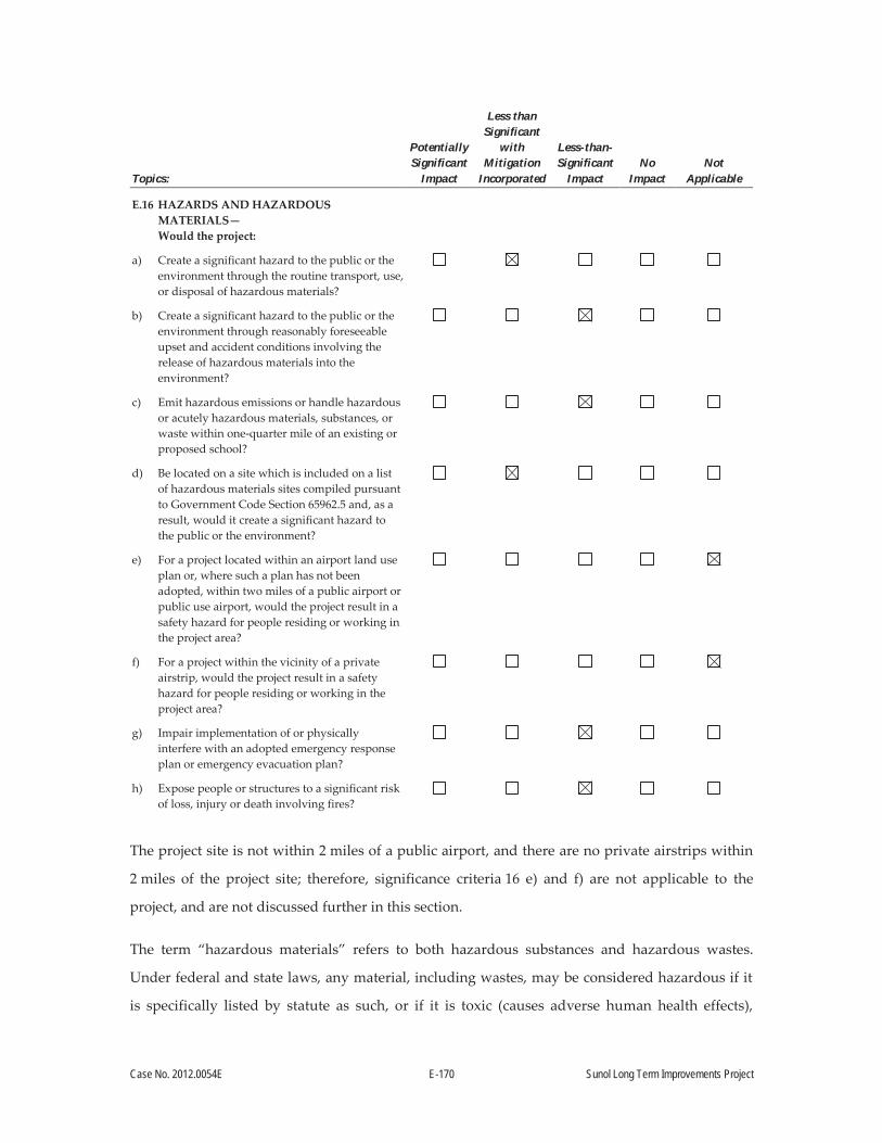
Case No. 2012.0054E E-170 Sunol Long Term Improvements Project
Topics:
Potentially Significant
Impact
Less than Significant
with Mitigation
Incorporated
Less-than- Significant
Impact No
Impact Not
Applicable
E.16 HAZARDS AND HAZARDOUS MATERIALS— Would the project:
a) Create a significant hazard to the public or the environment through the routine transport, use, or disposal of hazardous materials?
b) Create a significant hazard to the public or the environment through reasonably foreseeable upset and accident conditions involving the release of hazardous materials into the environment?
c) Emit hazardous emissions or handle hazardous or acutely hazardous materials, substances, or waste within one-quarter mile of an existing or proposed school?
d) Be located on a site which is included on a list of hazardous materials sites compiled pursuant to Government Code Section 65962.5 and, as a result, would it create a significant hazard to the public or the environment?
e) For a project located within an airport land use plan or, where such a plan has not been adopted, within two miles of a public airport or public use airport, would the project result in a safety hazard for people residing or working in the project area?
f) For a project within the vicinity of a private airstrip, would the project result in a safety hazard for people residing or working in the project area?
g) Impair implementation of or physically interfere with an adopted emergency response plan or emergency evacuation plan?
h) Expose people or structures to a significant risk of loss, injury or death involving fires?
The project site is not within 2 miles of a public airport, and there are no private airstrips within
2 miles of the project site; therefore, significance criteria 16 e) and f) are not applicable to the
project, and are not discussed further in this section.
The term “hazardous materials” refers to both hazardous substances and hazardous wastes.
Under federal and state laws, any material, including wastes, may be considered hazardous if it
is specifically listed by statute as such, or if it is toxic (causes adverse human health effects),

Case No. 2012.0054E E-171 Sunol Long Term Improvements Project
ignitable (has the ability to burn), corrosive (causes severe burns or damage to materials), or
reactive (causes explosions or generates toxic gases). The term “hazardous material” is defined as
any material that, because of quantity, concentration, or physical or chemical characteristics,
poses a significant present or potential hazard to human health and safety, or to the environment
if released into the workplace or the environment.200
Land use in the vicinity of project site is primarily agricultural, with open space, and commercial
and residential areas to the north in the town of Sunol. A search of the SWRCB’s GeoTracker201
and the California Department of Toxic Substances Control (DTSC)’s EnviroStor202 online
databases was conducted to identify hazardous materials sites within ¼ mile of the project site.
GeoTracker includes the following types of environmental cases: leaking underground storage
tank (LUST) sites; land disposal sites; military sites; DTSC cleanup sites; other cleanup sites;
permitted UST facilities; and permitted hazardous waste generators. EnviroStor includes federal
Superfund sites, state response sites, voluntary cleanup sites, school cleanup sites, corrective
action sites, and tiered permit sites. The following sites were listed as hazardous material sites:
SFPUC Sunol Yard and Sunol Pump Station. The Sunol Yard is a listed LUST case, and consists
of three areas on the property:
Sunol Pump Station. Three USTs, consisting of one 10,000-gallon diesel UST and two
400-gallon USTs were removed from the Pump Station in November 1993. Total
petroleum hydrocarbons as diesel (TPH-d), oils and grease, and semi-volatile organic
compounds were detected in soil samples collected from the tank excavations.
Sunol Yard. Three USTs, consisting of one 550-gallon regular gasoline UST, one
1,000-gallon unleaded gasoline UST, and one 550-gallon diesel UST were removed from
the southern portion of the Sunol Yard in May 1990. Total petroleum hydrocarbons as
gasoline, TPH-d, and benzene, toluene, ethylbenzene, and xylene were detected in soil
samples collected from the tank excavations.
200 California Health and Safety Code, Chapter 6.95, Section 25501(p). 201 SWRCB, 2014. GeoTracker Database. Available online at: http://geotracker.swrcb.ca.gov/. Accessed May
2014. 202 DTSC, 2014. EnviroStor Database. Available online at: http://www.envirostor.dtsc.ca.gov/public/.
Accessed May 2014.

Case No. 2012.0054E E-172 Sunol Long Term Improvements Project
Sunol Yard. An unlined sump near the southeastern corner of a storage shed in the Sunol
Yard was reportedly used for disposal of waste oil and other liquids. The storage shed
was approximately 50 feet southwest of the three USTs in the Sunol Yard (described
above). Total recoverable hydrocarbons, oil and grease, and volatile organic compounds
were detected in soil samples collected from the immediate vicinity of the sump.
The Sunol Yard has been operated by the SFPUC and its predecessor, the Spring Valley Water
Company, since the early 20th century. Site investigations and excavation activities were
conducted at various times until 2003. Investigations indicated that contaminants were not
migrating off site, and a recommendation was made to close the case.203
In February 2012, the Alameda County Health Care Services issued a Remedial Action
Completion Certification, closing the LUST case for the site.204 Oil and grease still remains in soil
near a storage shed, and TPH-d remains in groundwater at the pump station; therefore, the case
was closed with Site Management Requirements that limit future use of the site to the current
municipal corporation yard and pump station.
Other Sites. Two other LUST cases were identified in the vicinity in the GeoTracker database.
These were the Louthan Property and Chevron. Both cases are closed, and are on Main Street in
Sunol, nearly ¼ mile from the project site. These cases would not affect or be affected by the
proposed project, given the distance involved and due to the nature of the proposed project. No
other hazardous materials sites were identified near the project site.
Impact HZ-1: The project would not create a significant hazard to the public or the environment through the routine transport, use, or disposal of hazardous materials. (Less than Significant with Mitigation Incorporated)
Project construction would require the transport and use of fuels, lubricants, and solvents for
construction vehicles and equipment. Small quantities of these materials could be stored at the
site during project construction. It is reasonable to assume, for the purposes of this analysis, that
any hazardous materials needed for construction would be stored and used in accordance with
203 Kennedy/Jenks Consultants, 2011. Site Summary Report – SFPUC Sunol Yard, 505 Paloma Way, Sunol, California, K/J 1165008*00. May.
204 Wickham, Jeremy, 2011. Letter from Jeremy Wickham, Alameda County Environmental Health Department, to Casey Sondgeroth, San Francisco Public Utilities Commission. November.
Case No. 2012.0054E E-173 Sunol Long Term Improvements Project
the applicable regulations that specify hazardous materials storage and handling requirements,
such as proper container types, spill containment, and usage methods for minimizing the
potential for releases and harmful exposures. Regulatory requirements addressing the proper
storage, use, and transportation of hazardous materials are found in the California Fire Code,
California Health and Safety Code Hazardous Materials Business Plan regulations, and Caltrans
regulations.
Earth-moving activities such as excavation and grading can generate fugitive dust, which may
contain naturally occurring asbestos. Naturally occurring asbestos is associated with serpentine
bedrock. The project site is situated on deep alluvial sediments originating from Alameda Creek
and other nearby drainages. Surficial soils are mapped as Yolo Loam.205 Given the geomorphic
setting of the project site, there is very little potential for encountering natural serpentine soils,
which form in upland geomorphic positions on shallow and exposed serpentine bedrock.
Therefore, there is little potential for the proposed project to excavate deep enough to encounter
serpentine bedrock that may exist under the study area.
Structures that would be demolished are likely to contain lead-based paint (LBP) and asbestos-
containing materials (ACM), given their age. Buildings constructed prior to the 1980s often used
these materials. The Sunol Cottage was sampled in 2006 for LBP and ACM.206 Analytical results
indicated that loose and peeling paint in the cottage contained lead and several types of building
materials (e.g., heating, ventilation, and air conditioning ductwork insulation; roofing materials;
and some joint compounds and adhesives) were positive for asbestos. Removal of these materials
requires special handling and disposal procedures.207 Other buildings at Sunol Yard that would
be demolished as part of the proposed project have not been sampled for LBP and ACM.
Removal of LBP and ACM may present a health risk to workers, which would be a significant
impact. However, implementation of Mitigation Measure M-HZ-1, Hazardous Materials
Building Survey, would reduce risk to workers to less-than-significant levels by requiring
sampling of previously unsurveyed structures to determine if LBP and/or ACM are present, so
205 Natural Resources Conservation Service, United States Department of Agriculture, 2011. Web Soil Survey. Available online at: http://websoilsurvey.nrcs.usda.gov. Accessed December 12, 2011.
206 North Tower Environmental, 2006. Lead and asbestos sampling memorandum. Prepared for San Francisco Department of Public Works. July 27.
207 CCR Title 8 Sections 1529 and 1532.1.

Case No. 2012.0054E E-174 Sunol Long Term Improvements Project
that appropriate state and federal regulations regarding abatement and handling of these
materials, as well as worker safety, are implemented.
As discussed in Section E.15, Hydrology and Water Quality, above, water quality BMPs
required by the SFPUC’s construction contract specifications and/or by compliance with the
requirements of the Construction General Permit, would include BMPs designed to prevent
pollutants from contacting stormwater and moving off site into receiving waters. Examples of
hazardous materials BMPs to protect surface and groundwater from possible sources of
contamination include conducting routine inspections for leaks, placing drip pans underneath
parked vehicles, protecting the ground surface with tarps in equipment and materials storage
areas, storing incompatible hazardous materials separately, using secondary containment for
hazardous materials storage, keeping spill clean-up kits available on site, designating appropriate
sites in the construction area as refueling stations for construction vehicles, and maintaining
compliance records. Implementation of standard BMPs through adherence to regulations and
implementation the SFPUC’s Standard Construction Measures, in addition to Mitigation
Measure M-HZ-1, Hazardous Materials Building Survey, and then implementing applicable
regulatory requirements as a result of the survey results, would serve to further reduce impacts
due to the routine transport, use, or disposal of hazardous materials, to Less than Significant with
Mitigation Incorporated.
Operations at the Sunol Yard would not change substantially from current operations.
Hazardous materials stored and used at Sunol Yard include various petroleum products (oils,
grease, and fuel), paints, solvents, fertilizers, pesticides, and other materials as listed in the
Hazardous Materials Business Plan for the site.208 The site also contains existing USTs for gasoline
and diesel fuels. However, because project operation would not change substantially, ongoing
compliance with existing hazardous materials laws and regulations would ensure that the project
would have No Impact, due to the routine transport, use, or disposal of hazardous materials,
above existing baseline conditions.
208 AEW Engineering, Inc., 2013. Hazardous Materials Business Plan – Sunol Maintenance Yard. Sunol, California. Prepared for San Francisco Public Utilities Commission and San Francisco Department of Public Works.

Case No. 2012.0054E E-175 Sunol Long Term Improvements Project
Mitigation Measure M-HZ-1: Hazardous Materials Building Survey
For structures that have not been previously surveyed, and if the structure is known or
suspected to have been constructed prior to the 1980s, a hazardous building materials
survey shall be performed. The survey shall be conducted by a qualified environmental
professional, and the results shall be submitted to the SFPUC prior to removing the
structures at the Sunol Yard. If ACM are determined to be present, the materials shall be
abated by a certified asbestos abatement contractor in accordance with the regulations
and notification requirements of the BAAQMD, and in accordance with applicable
worker safety regulations. If LBP is identified, then loose or peeling paint will be
removed by a qualified lead abatement contractor, and disposed of in accordance with
existing hazardous waste and worker safety regulations.
Impact HZ-2: The project would not create a significant hazard to the public or the environment through reasonably foreseeable upset and accident conditions involving the release of hazardous materials into the environment. (Less than Significant)
No project-related processes or operations would create reasonably foreseeable upset and
accident conditions involving the release of large amounts of hazardous materials into the
environment. Hazardous materials used during construction, such as fuel for construction
equipment and vehicles, would be managed in accordance with applicable laws and regulations
as described under Impact HZ-1, including having spill containment and cleanup kits available
on site. Because project construction would involve relatively minor quantities of hazardous
materials, with mandatory compliance with existing hazardous materials laws and regulations,
the potential hazard of a release of hazardous materials resulting from an upset or accident
would be Less than Significant. As discussed above, project operation, relative to the use and/or
transport of hazardous materials, would not change substantially from existing conditions.
Impact HZ-3: The project would not emit hazardous emissions, but would handle limited amounts of hazardous materials within ¼ mile of an existing school. (Less than Significant)
The Sunol Glen Elementary School is approximately 825 feet northwest of the project site. Project
construction would not involve processes that would create hazardous emissions or use materials
in quantities that if spilled would create a hazard at the school. Dust emissions from the site
during construction would be controlled with construction BMPs, as discussed in Section E.7,
Air Quality, above.

Case No. 2012.0054E E-176 Sunol Long Term Improvements Project
Hazardous materials handling during construction would be limited to minimal amounts of fuels
and lubricants for construction vehicles and equipment; and paints, solvents, or other materials
used in the construction of new facilities. These materials are not considered acutely or extremely
hazardous as defined by the California Code of Regulations.209 In addition, it is reasonable to
assume that the handling of hazardous materials during project construction would be in
compliance with existing hazardous materials laws and regulations. Also, there would be no
substantial change in operations, relative to the use and/or transport of hazardous materials.
Therefore, the potential impact of hazardous materials use on individuals at the nearby Sunol
Glen Elementary School would be Less than Significant.
Impact HZ-4: The project would be located on a site that is included on a list of hazardous materials sites compiled pursuant to Government Code Section 65962.5; however, the project would not create a hazard to the public or the environment. (Less than Significant with Mitigation Incorporated)
The Sunol Pump Station and Sunol Yard is itself identified on regulatory agency lists compiled
pursuant to Government Code Section 65962.5. As described above, the site contained LUSTs.
The site has been remediated, and the case was closed as of February 15, 2012, with Site
Management Requirements that, due to the assumed continued presence of petroleum
hydrocarbons in site soils and groundwater, limit future use of the site to the current municipal
corporation yard and pump station.210
The project would involve excavations, typically not more than 5 feet below the existing ground
surface, but up to 15 feet deep to remove the existing USTs and for installation of the wastewater
holding tanks (see Section A.4.1, Sunol Corporation Yard Improvements). Because residual soil
and groundwater contamination exists at the former site in Sunol Yard, contaminated soils or
groundwater could be encountered; the project does not propose excavation work at the Sunol
Pump Station. As described in Section E.15, Hydrology and Water Quality, groundwater is
generally at greater depths than the planned excavations. Implementation of Mitigation
Measure M-HZ-4, Contingency Plan for Potential Encounters with Contaminated Soils or
Groundwater during Construction, would reduce the impact related to the project’s location on
209 CCR Title 22, Division 4.5, Chapter 11, Appendix X - List of Extremely Hazardous Wastes. 210 SWRCB, 2014. GeoTracker Database. Available online at: http://geotracker.waterboards.ca.gov. Accessed
August 2014.
Case No. 2012.0054E E-177 Sunol Long Term Improvements Project
a listed hazardous materials site to Less than Significant with Mitigation Incorporated, by requiring
specific procedures to be followed if contaminated soils or groundwater are encountered.
Mitigation Measure M-HZ-4: Contingency Plan for Potential Encounters with Contaminated Soils or Groundwater during Construction
For all ground-disturbing construction work at the Sunol Yard, the SFPUC shall require
the Contractor to prepare and implement a contaminated soils and groundwater
contingency plan that prescribes activities for workers to follow when the presence of soil
or groundwater contamination is suspected, based on prior onsite investigations or on
visual observation or smell. The plan shall include but is not limited to provisions for
daily briefings of construction staff prior to grading, trenching, or other ground-
disturbing construction work, regarding what to look for; a list of contact persons in case
of a possible encounter with contaminated soils or groundwater; provisions for
immediate notification of the SFPUC resident engineer; notification of the applicable
local enforcement agency, as well as consultation with that agency; and protocols for
further action. In instances where contamination is discovered, construction activities
within 30 feet of the potentially affected area (or other distance as identified by applicable
local enforcement agency) would cease until it is determined, in coordination with the
applicable local enforcement agency, that work can proceed without the risk of injury to
persons or the environment.
The plan will outline the steps to be taken if suspected contaminated soils or
groundwater or hazardous materials are discovered during excavation. The contingency
plan will be site specific. The procedures outlined below provide the protocols to identify
potential contamination and take appropriate action to avoid the spread of contaminants
into the surrounding environment and protect workers on-site.
The plan will include information on contamination or hazardous materials indicators
including but not limited to the following:
Intact or broken drums and containers. Unusual odors. Discolored or stained water seeps or soils. Petroleum hydrocarbon contaminated soil and/or free product. Broken pipes or fragments or other buried debris. Unusual lack of or stressed vegetation.

Case No. 2012.0054E E-178 Sunol Long Term Improvements Project
The plan shall require the Contractor to actively monitor for the indictors.
In the event that an indicator is identified, the plan will identify required actions
including the following:
Stop all work within a 30 foot radius of the area where the suspect material/emission/discharge (or other distance as identified by the applicable local enforcement agency). Work shall not resume within a 30 foot radius of the area unless authorized by the SFPUC resident engineer. Contractor staff will immediately notify the onsite Contractor site supervisor and SFPUC resident engineer. The Contractor will cordon off the area as practicable with a suitable barrier (e.g., caution tape or orange high visibility fencing). SFPUC resident engineer will notify the applicable local enforcement agency that potential contamination has been discovered and contingency action is being implemented. As consistent with direction from the applicable local enforcement agency, the Contractor will characterize the potential contamination by collecting and submitting samples for laboratory analysis. In consultation with SFPUC resident engineer and the applicable local enforcement agency, the Contractor will implement controls to isolate the contaminated material, including prevention of migration. When the material characteristics have been established, the Contractor will implement appropriate disposal options in consultation with SFPUC and the local enforcement agency (e.g., removal and disposal at an appropriately licensed landfill).
The Contractor will ensure that material hauling will be conducted in accordance with all
local, state and federal laws regarding material handling and transport.
Impact HZ-5: The project would not impair implementation of or physically interfere with an adopted emergency response plan or emergency evacuation plan. (Less than Significant)
Project construction could interfere with an adopted emergency response plan or emergency
evacuation plan if construction activities were to involve the complete or partial closure of
important roadways, interfere with identified evacuation routes, restrict access for emergency
response vehicles, or restrict access to critical facilities such as hospitals or fire stations. However,
construction at the project site would occur within the limits of existing SFPUC property or
easements, and would not interfere with any important roadways. Worker trips and equipment
deliveries would cause minimal increases in traffic on public roads. Therefore, the project impact

Case No. 2012.0054E E-179 Sunol Long Term Improvements Project
related to interference with an adopted emergency response plan or emergency evacuation plan
would be Less than Significant.
Impact HZ-6: The project would not expose people or structures to a significant risk of loss, injury, or death involving fires. (Less than Significant)
As described above, project operation would not change substantially from existing conditions,
and the proposed project would not represent an increased fire hazard over existing conditions.
During construction, the use of vehicles and equipment—as well as the temporary onsite storage
and use of small quantities of diesel fuel, gasoline, and lubricants—could pose a fire risk.
Potential sources of ignition include equipment with internal combustion engines; gasoline-
powered tools; and equipment or tools that produce a spark, fire, or flame. Smoking by
construction personnel could also be a potential source of ignition during construction. The Sunol
Yard is largely cleared of shrubs and trees, although such vegetation is present along the western
boundary.
Regulations governing the use of construction equipment in fire-prone areas are designed to
minimize the risk of wildland fires. Fire-prone areas include any forest-, brush-, or grass-covered
land. These regulations restrict the use of equipment that may produce a spark, flame, or fire;
require the use of spark arrestors on construction equipment that has an internal combustion
engine; specify requirements for the safe use of gasoline-powered tools in fire hazard areas; and
specify fire suppression equipment that must be provided for various types of work in fire-prone
areas. The project would also be subject to the requirements of the California Fire Code. Fire code
regulations (Chapter 14 of the California Fire Code) also address fire safety during construction.
Construction precautions against fire must include the following: prohibitions on smoking except
in approved areas; appropriate storage of materials susceptible to ignition, such as flammable
and combustible liquids, and oily rags; procedures for cutting and welding; and maintenance of
portable fire extinguishers and water for firefighting.
With adherence to these mandatory requirements, impacts related to fires from project
construction would be Less than Significant.
Case No. 2012.0054E E-180 Sunol Long Term Improvements Project
Impact C-HZ: The proposed project, in combination with past, present, and reasonably foreseeable future projects in the vicinity, would not have a significant cumulative impact related to hazards and hazardous materials. (Less than Significant with Mitigation Incorporated)
Impacts could result from the project’s use of hazardous materials during construction. These
impacts would be primarily restricted to the project area and immediate vicinity; therefore, the
geographic scope for cumulative impacts from hazards includes the project area and immediate
vicinity.
The project would use common construction-related hazardous materials (fuels, lubricants, and
solvents). All of the cumulative projects listed in Table 9 that would be constructed in the vicinity
of the proposed project could potentially use hazardous materials during construction. However,
as discussed in Impact HZ-1, it is reasonable to assume that hazardous materials needed for
construction would be stored and used in accordance with the applicable regulations that specify
hazardous materials storage and handling requirements, such as proper container types, spill
containment, and usage methods for minimizing the potential for releases and harmful
exposures. Regulatory requirements addressing the proper storage, use, and transportation of
hazardous materials are found in the California Fire Code, California Health and Safety Code
Hazardous Materials Business Plan regulations, and Caltrans regulations. Structures that would
be demolished are likely to contain lead based paint (LBP) and asbestos containing materials
(ACM) depending on their age. Mitigation Measure M-HZ-1, Hazardous Materials Building
Survey, would be implemented for all buildings proposed to be demolished that were
constructed prior to 1980 and that have not previously been surveyed. If LBP and/or ACM are
present, appropriate state and federal regulations regarding abatement and handling of these
materials, as well as worker safety, would be implemented.
As discussed in Section E.15, Hydrology and Water Quality (above), water quality BMPs
required by the SFPUC’s construction contract specifications and/or by compliance with the
requirements of the Construction General Permit, would include BMPs designed to prevent
pollutants from contacting stormwater and moving off-site into receiving waters. Examples of
hazardous materials BMPs to protect surface and groundwater from possible sources of
contamination include conducting routine inspections for leaks, placing drip pans underneath
parked vehicles, protecting the ground surface with tarps in equipment and material storage
areas, storing incompatible hazardous materials separately, using secondary containment for
hazardous materials storage, keeping spill clean-up kits available on-site, designating
Case No. 2012.0054E E-181 Sunol Long Term Improvements Project
appropriate sites within the construction area as refueling stations for construction vehicles, and
maintaining compliance records. Implementation of standard BMPs, through adherence to
regulations and implementation of the SFPUC’s Standard Construction Measures, in addition to
Mitigation Measure M-HZ-1, Hazardous Materials Building Survey, would serve to further
reduce impacts due to the routine transport, use, or disposal of hazardous materials, below less-
than-significant levels. Because the potentially cumulative projects listed in Table 9 would be
subject to these same requirements, potential cumulative impacts from use of hazardous
materials during construction would be Less than Significant.
As discussed in Impact HZ-4, The Sunol Pump Station and Sunol Yard is itself identified on
regulatory agency lists compiled pursuant to Government Code Section 65962.5. As described
above, the site contained leaking underground storage tanks. The site has been remediated and
the case was closed as of February 15, 2012 with Site Management Requirements that limit future
use of the site to the current municipal corporation yard and pump station due to the assumed
continued presence of petroleum hydrocarbons in site soils and groundwater.211
The project would involve excavations, typically not more than 5 feet below the existing ground
surface, but would be deeper to remove the existing USTs and for installation of the wastewater
holding tanks, up to 15 feet deep (see Section A.4.1, Sunol Corporation Yard Improvements).
Because residual soil and groundwater contamination exists at the former site in the Sunol Yard,
contaminated soils or groundwater could be encountered, which would be a significant
cumulative impact. However, the project does not propose excavation work at the Sunol Pump
Station. Nevertheless, as described in Section E.15, Hydrology and Water Quality, groundwater
is generally at greater depths than the planned excavations. In addition, implementation of
Mitigation Measure M-HZ-4, Contingency Plan for Potential Encounters with Contaminated
Soils or Groundwater during Construction, would reduce the potential impact related to the
project’s location on a listed hazardous materials site to Less than Cumulatively Considerable with
Mitigation Incorporated by requiring that specific regulatory procedures be followed if
contaminated soil or groundwater are encountered (Less than Significant with Mitigation
Incorporated).
211 Ibid.

Case No. 2012.0054E E-182 Sunol Long Term Improvements Project
Topics:
Potentially Significant
Impact
Less than Significant
with Mitigation
Incorporated
Less-than-Significant
Impact No
Impact Not
Applicable
E.17 MINERAL AND ENERGY RESOURCES—Would the project:
a) Result in the loss of availability of a known mineral resource that would be of value to the region and the residents of the state?
b) Result in the loss of availability of a locally-important mineral resource recovery site delineated on a local general plan, specific plan or other land use plan?
c) Encourage activities which result in the use of large amounts of fuel, water, or energy, or use these in a wasteful manner?
Impact MER-1: The project would not result in the loss of availability of a known mineral resource that would be of value to the region and the residents of the state. (No Impact)
A portion of the SFPUC land where the Watershed Center would be constructed is currently
leased to Mission Valley Rock Company and operated by Lehigh Hanson, an active sand and
gravel mining operation in Sunol Valley. The operation comprises active excavation areas,
maintenance and operations buildings, pits, silt/holding basins, processing facilities, and other
outdoor equipment and materials storage areas. Although the lease would need to be modified to
construct the Watershed Center at the proposed location, the area to be returned to SFPUC use
lies outside of the limit of mining defined by the lease agreement, and was never intended nor
planned to become part of the actively mined quarry.212 Furthermore, in the South San Francisco
Bay Region Aggregate Study Area, the volume of permitted aggregate reserves is 404 million
tons, which is 29 percent of the projected 50-year demand for the area.213 Therefore, the project
would not result in the loss of availability of a known mineral resource that would be of value to
the region and the residents of the state (No Impact).
212 SFPUC, 2000. Quarry Lease between City and County of San Francisco and Mission Valley Rock Company. Alameda County, California. September.
213 California Geological Survey, 2012. Aggregate Sustainability in California. Department of Conservation. Map Sheet 52.

Case No. 2012.0054E E-183 Sunol Long Term Improvements Project
Impact MER-2: The project would not result in the loss of availability of a locally important mineral resource recovery site delineated on a local general plan, specific plan, or other land use plan. (No Impact)
The project site is not designated as a locally important mineral resource recovery site in the East
County Area Plan.214 Therefore, the project would not result in the loss of availability of a locally
important mineral resource recovery site (No Impact).
Impact MER-3: The project would not encourage activities that result in the use of large amounts of fuel, water, or energy; or use these in a wasteful manner. (Less than Significant)
Some quantities of fuel, water, and energy would be required to construct Sunol Yard
improvements and the Watershed Center. Construction activities would not result in the use of
large amounts of these items, or use them in a wasteful manner, because the construction
contractor would have a very direct economic incentive to avoid doing so.
Three of the nine main project objectives are to:
Reduce environmental effects and enhance energy efficiency through design and
construction of buildings conforming to California Title 24 energy use standards, and
secure LEED Gold certification for a replacement administration building, consistent
with San Francisco green building requirements for municipal construction projects;
Revise the layout of the Sunol Corporation Yard to be more useable and efficient; and
Secure LEED Gold certification for the Watershed Center, in accordance with San
Francisco green building requirements for municipal construction projects, and ensure
project design and construction is consistent with the California Building Standards Code
(2013), SFPUC seismic reliability standards, and ADA requirements (see Section A.3,
Project Purpose, above).
As a result, operation of the Sunol Corporation Yard would require less energy after project
completion, due to conforming to California Title 24 energy use standards, securing LEED Gold
certification for a replacement administration building, improving the layout of Sunol Yard to be
operated more efficiently. The Watershed Center would also be constructed to secure LEED Gold
certification, in accordance with San Francisco green building requirements. Therefore, operation
214 Alameda County Planning, 1994 [Revised 2000]. East County Area Plan. May 1994 [Revised November 2000].
Case No. 2012.0054E E-184 Sunol Long Term Improvements Project
of both the improved Sunol Yard and the Watershed Center would not result in the wasteful use
of energy, and impacts would be Less than Significant.
Impact C-MER: The proposed project, in combination with past, present, and reasonably foreseeable future projects in the vicinity, would not have a significant cumulative impact related to mineral and energy resources. (Less than Significant)
As stated above, the project would result in no impact on mineral resources; therefore, the project
would not contribute to any significant cumulative impact on mineral resources.
The geographic scope for potential cumulative impacts associated with the use of fuel, water, or
energy encompasses the SFPUC water and power supply system. SFPUC supplies the city and
county of San Francisco as well as others in the region with water and power. All of the cumulative
projects listed in Table 9 within the vicinity and other projects in the region would require the use
of fuel, water, or energy. The proposed project and other projects in the region would be required
to comply with the California Green Building Standards Code. Because this code encourages
sustainable construction practices related to planning and design, energy efficiency, and water
efficiency and conservation, it can be reasonably assumed that energy consumption would be
reduced compared to conditions without such regulation. As a result, potential cumulative
impacts related to the wasteful use of energy resources would be Less than Significant.
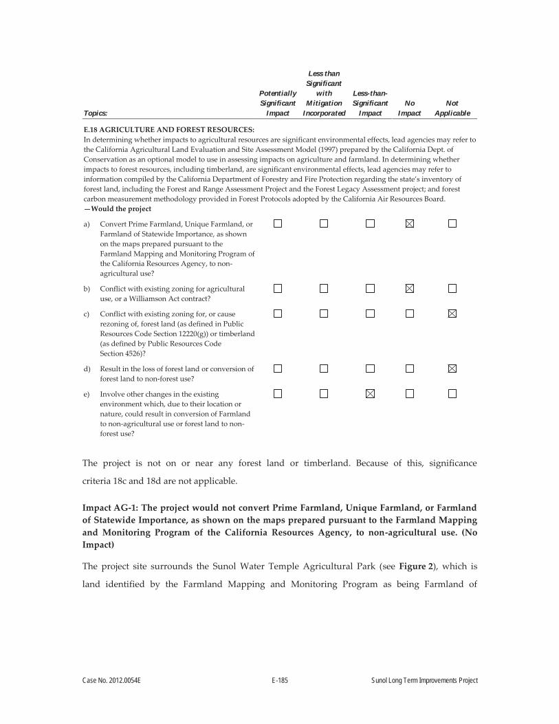
Case No. 2012.0054E E-185 Sunol Long Term Improvements Project
Topics:
Potentially Significant
Impact
Less than Significant
with Mitigation
Incorporated
Less-than-Significant
Impact No
Impact Not
Applicable
E.18 AGRICULTURE AND FOREST RESOURCES: In determining whether impacts to agricultural resources are significant environmental effects, lead agencies may refer to the California Agricultural Land Evaluation and Site Assessment Model (1997) prepared by the California Dept. of Conservation as an optional model to use in assessing impacts on agriculture and farmland. In determining whether impacts to forest resources, including timberland, are significant environmental effects, lead agencies may refer to information compiled by the California Department of Forestry and Fire Protection regarding the state’s inventory of forest land, including the Forest and Range Assessment Project and the Forest Legacy Assessment project; and forest carbon measurement methodology provided in Forest Protocols adopted by the California Air Resources Board. —Would the project
a) Convert Prime Farmland, Unique Farmland, or Farmland of Statewide Importance, as shown on the maps prepared pursuant to the Farmland Mapping and Monitoring Program of the California Resources Agency, to non-agricultural use?
b) Conflict with existing zoning for agricultural use, or a Williamson Act contract?
c) Conflict with existing zoning for, or cause rezoning of, forest land (as defined in Public Resources Code Section 12220(g)) or timberland (as defined by Public Resources Code Section 4526)?
d) Result in the loss of forest land or conversion of forest land to non-forest use?
e) Involve other changes in the existing environment which, due to their location or nature, could result in conversion of Farmland to non-agricultural use or forest land to non-forest use?
The project is not on or near any forest land or timberland. Because of this, significance
criteria 18c and 18d are not applicable.
Impact AG-1: The project would not convert Prime Farmland, Unique Farmland, or Farmland of Statewide Importance, as shown on the maps prepared pursuant to the Farmland Mapping and Monitoring Program of the California Resources Agency, to non-agricultural use. (No Impact)
The project site surrounds the Sunol Water Temple Agricultural Park (see Figure 2), which is
land identified by the Farmland Mapping and Monitoring Program as being Farmland of

Case No. 2012.0054E E-186 Sunol Long Term Improvements Project
Statewide Importance.215 There is additional Farmland of Statewide Importance across Arroyo de
la Laguna to the west of the project site. Although the project site surrounds the Sunol Water
Temple Agricultural Park, none of the land identified as Farmland of Statewide Importance
would be impacted by the project. Access and utilities to the Sunol Water Temple Agricultural
Park would not be altered. Because no land identified as Prime Farmland, Unique Farmland, or
Farmland of Statewide Importance would be converted to non-agricultural use, the project would
result in No Impact.
Impact AG-2: The project would not conflict with existing zoning for agricultural use or a Williamson Act contract. (No Impact)
Local governments use Williamson Act contracts to help preserve agricultural lands and
discourage urban development by reducing the property taxes a farmer would be required to pay
if the land was not under a Williamson Act contract. None of the land in or immediately
surrounding the project site is under a Williamson Act contract; therefore, No Impact to
Williamson Act contracts would result from the project.
Impact AG-3: The project would not involve other changes in the existing environment which, due to their location or nature, could result in conversion of Farmland to non-agricultural use or forest land to non-forest use. (Less than Significant)
The project would remove approximately 2 acres of land that are currently cultivated as a hay/
grain field in the southeastern part of the project site. This land (although not identified by the
Farmland Mapping and Monitoring Program as Prime Farmland, Unique Farmland, or Farmland
of Statewide Importance) is in a buffer area surrounding the adjacent quarry. The lease that the
current quarry operator has with SFPUC would need to be amended to allow the Watershed
Center to be constructed at the proposed location. Although 2 acres of farmland would be
converted to a non-agricultural use, it would not represent a significant loss of agricultural land
when compared to the approximately 250,000 acres of total agricultural land in Alameda County,
representing a loss of less than one-thousandth of a percent of the county total.216 Therefore,
impacts associated with farmland conversion would be Less than Significant.
215 California Department of Conservation, 2013. Important Farmland Maps. July. 216 California Department of Conservation, 2013. Farmland Mapping and Monitoring Program, Alameda County
2010-2012 Land Use Conversion. Available online at: http://www.consrv.ca.gov/dlrp/fmmp/Pages/Alameda.aspx. Accessed August 5, 2014.

Case No. 2012.0054E E-187 Sunol Long Term Improvements Project
Impact C-AG: The proposed project, in combination with past, present, and reasonable foreseeable future projects in the vicinity, would not have a significant cumulative impact related to agricultural and forest resources. (Less than Significant)
The geographic scope for potential cumulative impacts related to agricultural and forest
resources encompasses the area of the project site and vicinity, which generally includes open
space and park lands, Farmland of Statewide Importance, quarry operations adjoining the project
site to the east, and the Town of Sunol to the north. Cumulative projects listed in Table 9 above
that are located within this geographic scope include the Town of Sunol Fire Suppression Project,
the SMP-32 Quarry Operations, and the Alameda County Fire Department Sunol Project.
Two of the identified cumulative projects would not convert farmland to non-agricultural use.
The addition of fire hydrants and increased flows associated with the Town of Sunol Fire
Suppression Project would not convert farmland to non-agricultural uses in the project vicinity,
and the Alameda County Fire Department Sunol Project would develop a currently undeveloped
parcel of land and would not convert farmland to non-agricultural uses. However, the SMP-32
Quarry has converted approximately 85 acres of previously cultivated lands to non-agricultural
uses since operations began in early 2006. As discussed above under Impact AG-3, approximately
2 acres of cultivated farmland would be converted to a non-agricultural use, but no Prime
Farmland, Unique Farmland, or Farmland of Statewide Importance would be impacted by the
SLTI project. Together, the proposed project and the SMP-32 quarry operations could have a
significant cumulative impact on agricultural land in the geographic scope. However, the
project’s conversion of 2 acres of land to a non-agricultural use would not be a considerable
contribution to the cumulative impact (Less than Significant).

Case No. 2012.0054E E-188 Sunol Long Term Improvements Project
Topics:
Potentially Significant
Impact
Less than Significant
with Mitigation
Incorporated
Less-than-Significant
Impact No
Impact Not
Applicable
E.19 MANDATORY FINDINGS OF SIGNIFICANCE—Would the project:
a) Have the potential to degrade the quality of the environment, substantially reduce the habitat of a fish or wildlife species, cause a fish or wildlife population to drop below self-sustaining levels, threaten to eliminate a plant or animal community, reduce the number or restrict the range of a rare or endangered plant or animal, or eliminate important examples of the major periods of California history or prehistory?
b) Have impacts that would be individually limited, but cumulatively considerable? (“Cumulatively considerable” means that the incremental effects of a project are considerable when viewed in connection with the effects of past projects, the effects of other current projects, and the effects of probable future projects.)
c) Have environmental effects that would cause substantial adverse effects on human beings, either directly or indirectly?
Impact MF-1: The project could have a substantial adverse effect, either directly or through habitat modifications, on species identified as a candidate, sensitive, or special-status species. (Less than Significant with Mitigation Incorporated)
The discussion in Section E, Evaluation of Environmental Effects, identifies potentially
significant impacts on the environment related to cultural resources, recreation, biological
resources, and hazards/hazardous materials. However, mitigation measures have been provided
to address these potentially significant project-level impacts. Implementation of the mitigation
measures would reduce the impacts to a less-than-significant level.
As discussed in Impact BI-1 in Section E.13, Biological Resources, project impacts on three
special-status species that have a moderate or high potential to occur in or adjacent to the project
site—white-tailed kite, loggerhead shrike, and San Francisco dusky-footed woodrat—would be
less than significant with implementation of the following mitigation measures: Mitigation
Measure M-BI-1a: Nesting Bird Survey Protection; and Mitigation Measure M-BI-1b:
Preconstruction Survey for San Francisco Dusky-Footed Woodrat (Less than Significant with
Mitigation Incorporated).

Case No. 2012.0054E E-189 Sunol Long Term Improvements Project
Impact MF-2: The project could cause a substantial adverse change in the significance of a historical resource (Less than Significant with Mitigation Incorporated)
As discussed in Impacts CP-1, CP-2, and CP-4, implementation of the proposed project could
result in a substantial adverse change in the significance of a historical resource, an
archaeological resource, a paleontological resource, or human remains. These impacts would be
less than significant with implementation of Mitigation Measure M-CP-1a: Historic Resources
Protection Plan; Mitigation Measure M-CP-1b: Preconstruction Surveys and Vibration
Monitoring; Mitigation Measure M-CP-1c: Secretary of the Interior’s Standards for Treatment
of Historic Properties; Mitigation Measure M-CP-2a: Treatment of Known Archaeological
Resources; Mitigation Measure M-CP-2b: Archaeological Monitoring and Accidental (Post-
review) Discovery of Archaeological Resources; and Mitigation Measure M-CP-4: Accidental
Discovery of Human Remains.
Therefore, impacts related to elimination of important examples of California history or
prehistory are Less than Significant with Mitigation Incorporated.
Impact MF-3: The proposed project could have impacts that would be individually limited, but cumulatively considerable. (Less than Significant with Mitigation Incorporated)
Section 15130 of the state CEQA Guidelines requires a reasonable analysis of the significant
cumulative impacts of a proposed project. Cumulative impact refers to “two or more individual
effects that, when considered together, are considerable or able to compound or increase other
environmental impacts.” The individual effects may be changes resulting from a single project or
an increase in the number of environmental impacts. The cumulative impact is the change in the
environment that results when the incremental impact of the project is added to closely
related past, present, or reasonably foreseeable future projects. Cumulative impacts can result
from individually minor but collectively significant projects that take place over a period of time
(CEQA Guidelines Section 15355 [a][b]).
Recently approved and reasonably foreseeable projects and planning efforts in the vicinity of the
project site are presented in Table 9, Cumulative Projects in the Sunol Long Term Improvements
Project Vicinity.
This initial study determined that the proposed project would have no impact or the criteria are
not applicable for population and housing, and wind and shadow. Therefore, the proposed
project would not contribute to cumulative impacts related to these issue areas.

Case No. 2012.0054E E-190 Sunol Long Term Improvements Project
The assessment of potential cumulative impacts for the remaining environmental issue areas is
provided in the relevant subsections of Section E, Evaluation of Environmental Effects.
However, for the reasons described in Sections E.1 through E.19, with implementation of
mitigation measures to address potentially significant project-level impacts, the proposed
project’s contribution to all cumulative impacts on the environment would not be cumulatively
considerable (Less than Significant with Mitigation Incorporated).
Impact MF-4: The proposed project could have environmental effects that would cause substantial adverse effects on human beings, either directly or indirectly. (Less than Significant with Mitigation Incorporated)
The discussion in Section E, Evaluation of Environmental Effects, identifies potentially
significant impacts related to cultural resources, recreation, biological resources, and hazards/
hazardous materials. Of these, impacts related to recreation and hazards/hazardous materials
could adversely affect human beings. Mitigation measures have been provided in this initial
study to reduce these potentially significant project-level impacts to a less-than-significant level.
No project-level significant impacts were identified for the following environmental issue areas:
land use; aesthetics; population and housing; transportation and circulation; noise; air quality;
GHG emissions; wind and shadow; utilities and service systems; public services; geology and
soils; hydrology and water quality; mineral and energy resources; and agricultural and forest
resources. Therefore, with implementation of the mitigation measures specified in Sections E.1
through E.18, the proposed project would not result in substantial adverse effects, direct or
indirect, on human beings (Less than Significant with Mitigation Incorporated).

Case No. 2012.0054E F-1 Sunol Long Term Improvements Project
F. MITIGATION MEASURES
The following mitigation measures have been adopted by the project sponsor, and are necessary
to avoid potential significant impacts of the proposed project.
Mitigation Measure M-CP-1a: Historic Resources Protection Plan
The SFPUC shall retain a qualified engineer, in coordination with a qualified historic
architect or architectural historian, to prepare a historic resources protection plan that
specifies actions and methods that the contractor will undertake to reduce the likelihood
of accidental collision damage to the Sunol Water Temple, Carrefour, and Sunol Valley
Filter Beds when construction equipment pass in proximity to these historical resources.
The plan shall require the Contractor to monitor activities to ensure use of protective
measures. At a minimum, the plan shall address: 1) guidelines for the operation of
construction equipment near the historical resources; 2) storage of construction materials
and equipment away from the resources, as appropriate; 3) pre- and post-construction
recording of the Sunol Water Temple, Carrefour, and the Sunol Valley Filter Beds to
confirm post-construction condition; 4) requirements for monitoring and documenting
compliance with the plan; and 5) use of exclusion fencing, and/or signs and education/
training of construction workers about the protection of the historical resources. The plan
shall be reviewed and approved by the SFPUC and implemented prior to use of project
construction equipment in these three areas. In case accidental damage occurs during the
construction of the project, the plan shall also direct the Contractor to stop the work
activity that caused the damage, propose interim protection measures, and develop
repair measures. The repair measures shall be reviewed and approved by the SFPUC
prior to Contractor implementation, and will be monitored by the SFPUC for compliance
with Secretary of the Interior’s Standards for Treatment of Historic Properties.
Mitigation Measure M-CP-1b: Preconstruction Surveys and Vibration Monitoring
Prior to construction, the SFPUC shall retain the services of a California-licensed
geotechnical engineer or similarly qualified expert in vibration effects on structures to
1) assess the potential for vibration effects on the Sunol Water Temple, Carrefour, and
Sunol Valley Filter Beds from construction activities; 2) identify pre-construction and
construction-period activities to be conducted by the contractor to monitor for and report
Case No. 2012.0054E F-2 Sunol Long Term Improvements Project
on potential vibration effects, including settlement and cracking; and 3) identify
measures to be undertaken by the contractor if vibration effects are identified during
monitoring, such as stopping adverse construction activities, contractor use of alternative
construction methods that reduce the potential for vibratory impacts, and reduced
vehicle speeds. The SFPUC shall also implement Mitigation Measure M-CP-1c,
Secretary of the Interior’s Standards for Treatment of Historic Properties, to repair
damage to onsite historical resources caused by the project.
Mitigation Measure M-CP-1c: Secretary of the Interior’s Standards for Treatment of Historic Properties
Details of the proposed repair work to the Carrefour, including but not limited to plans,
drawings, and photographs of existing conditions, shall be submitted by the SFPUC to
the San Francisco Planning Department prior to implementation. An architectural
historian that meets the Secretary of the Interior’s Professional Qualification Standards
within the Planning Department will review the proposed project for compliance with
the Standards. If necessary, the SFPUC shall pursue and implement a redesign of the
proposed repair work to the Carrefour to the extent feasible, so that consistency with the
Standards is achieved and/or a significant impact is avoided, as determined by the
Planning Department.
Mitigation Measure M-CP-2a: Treatment of Known Archaeological Resources
The SFPUC shall retain the services of a qualified archaeological consultant, meeting the
Secretary of Interior standards for archaeology, from the pool of qualified archaeological
consultants maintained by the Planning Department Archeologist, or an alternate
archaeological consultant on approval of the ERO. The archaeological consultant shall
develop and undertake any archaeological monitoring, testing, and mitigation programs
required in connection with this Mitigation Measure, the scope and implementation of
which shall be directed and approved by the ERO or designee.217
Archaeological site CA-ALA-565/H. In consultation with the ERO or designee, the
archaeological consultant shall design and carry out an archaeological testing program at
217 San Francisco Planning Department, 2008. MEA WSIP Projects Archaeological Guidance.

Case No. 2012.0054E F-3 Sunol Long Term Improvements Project
CA-ALA-565/H. The goal of the testing program shall be to provide an enhanced
delineation of the archaeological site’s structure and content in areas of planned
construction. The plan shall also detail the participation of Native American cultural
resource monitors during excavation and testing. The testing program shall be
documented to the ERO in a preapproved format.
On the basis of the testing results and in consultation with the ERO or designee, the
consultant shall prepare an Archaeological Research Design and Treatment Plan
(ARDTP) for the recovery and treatment of resources determined to be potentially
eligible to the California Register of Historical Resources (CRHR). The ARDTP shall
identify how data recovery and other treatments, such as development of interpretive
materials, will preserve the significant information of the archaeological resources to be
impacted by the project. That is, the ADRTP will identify what scientific/historical
research questions are applicable to the expected resource, what data classes the resource
is expected to possess, and how the expected data classes would address the applicable
research questions. The ADRTP will establish the procedures for data recovery and other
treatments, describe how the investigation will address the research issues, and specify
that the results will be provided in an Archaeological Data Recovery Report to the ERO
or designee following implementation of the ARDTP. In general, data recovery shall be
limited to the portions of the archaeological resource that could be adversely affected by
the proposed project. The ARDTP shall include the elements specified in EP’s
Archaeological Guidance #7, including goals of the plan, description of the resource,
research questions, field methods for recovering resources, laboratory methods, other
treatment options (i.e., interpretive programs), and details on Native American
coordination, as well as a practical work plan to carry out the program. The SFPUC shall
ensure that the provisions of the ARDTP are carried out.
Archaeological site SYIP-1. The archaeological consultant shall monitor and, as
necessary, direct the demolition of the Sunol Cottage and administration building to
better determine the vertical and horizontal extent, and potential significance, of the
Case No. 2012.0054E F-4 Sunol Long Term Improvements Project
cultural deposit SYIP-1.218 The buildings shall be deconstructed in a manner that
minimizes impacts to the deposit below the crawl space; for example, by first removing
all walls and roofs above the subfloor, then carefully deconstructing the subfloor. The
SFPUC shall ensure that archaeological resources uncovered during this process are
protected until the ERO or designee has determined appropriate treatment. The results of
this phase of work shall be documented to the ERO in a letter report.
In consultation with the archaeological consultant, the ERO or designee shall determine if
new discoveries made during fieldwork at SYIP-1 appear to constitute historical
resources. If the ERO determines that the newly discovered archaeological resources
constitute historical resources, the ERO may require treatment such as archaeological
data recovery or the creation of an interpretive product. Treatment, if required, shall be
presented in an ADRTP, as described above, prior to implementing data recovery. The
SFPUC shall ensure that the provisions of the ARDTP are carried out.
Plan approvals and distribution. All plans and reports prepared by the consultant
further to this Mitigation Measure shall be submitted first and directly to the ERO or
designee for review and comment, and shall be considered draft reports subject to
revision until final approval by the ERO. Once approved, copies of the reports shall be
distributed as follows: the California Historical Resources Information Center (NWIC)
shall receive one copy; the ERO shall receive a copy of the transmittal of the reports to the
NWIC. EP shall receive one bound, one unbound, and one unlocked, searchable PDF
copy on CD (of archival quality) as well as copies of any formal site recordation forms
(CA DPR 523 series), and/or documentation for nomination to the CRHR. In instances of
high public interest or interpretive value, the ERO may require a different final report
content, format, and distribution than that presented above.
218 URS, 2014. Final Historic Context and Archaeological Survey Report, an Archaeological Survey of the Sunol Long Term Improvements Project Area, Alameda County, California. Prepared for San Francisco Public Utilities Commission and San Francisco Planning Department, Environmental Planning Division.

Case No. 2012.0054E F-5 Sunol Long Term Improvements Project
Mitigation Measure M-CP-2b: Archaeological Monitoring and Accidental (Post-review) Discovery of Archaeological Resources
This Mitigation Measure is required to avoid and/or minimize potential adverse effects of
construction-related activities on previously unknown, accidentally discovered, and
potentially important resources by ensuring that they are recognized, protected, and
treated appropriately.
Monitoring Plan. The SFPUC shall retain the services of an archaeological consultant
meeting the Secretary of Interior standards for archaeology from the pool of qualified
archaeological consultants maintained by the Planning Department archaeologist or an
alternate archaeological consultant upon approval of the ERO. In consultation with the
ERO or designee, the consultant shall prepare an Archaeological Monitoring Plan (AMP)
in conformity to EP’s Archaeological Guidance that specifies how archaeological
monitoring shall be carried out on the project site, including monitoring locations,
authority of the archaeological monitor, reporting, and steps to be implemented in the
event of a discovery, including Native American coordination. The SFPUC shall ensure
that the terms of the AMP are carried out.
ALERT Sheet and Training. The SFPUC shall ensure, prior to any soils disturbing
activities, the distribution of the Planning Department’s archaeological resource
“ALERT” sheet to all personnel (including, machine operators, field crew, supervisory
personnel, etc.) of the project prime contractor, any project subcontractor and any utilities
firm involved in soils disturbing activities within the project site (including demolition,
excavation, grading, foundation work, etc.). The SFPUC shall provide the ERO with a
signed affidavit from the responsible parties (prime contractor, subcontractor[s], and
utilities firm) confirming that all field personnel have received copies of the Alert Sheet.
A preconstruction training shall be provided to all construction personnel by a qualified
archaeologist prior to their starting work on the project. The training may be provided in
person or using a video or handout prepared by the qualified archaeologist. The purpose
of the training is to enable personnel to identify archaeological resources that may be
encountered and to instruct them on what to do if a potential discovery occurs.
The SFPUC shall ensure that the following actions are carried out if any indication of an
archaeological resource is encountered during any soils disturbing activity of the project:
1/ The project Contractor, SFPUC, or archaeological monitor shall immediately notify the

Case No. 2012.0054E F-6 Sunol Long Term Improvements Project
ERO or designee and the Contractor shall immediately suspend any soils disturbing
activities within a minimum of 50 feet of the discovery until the ERO or designee has
determined what additional measures shall be undertaken. This radius may be reduced
at the discretion of the onsite archaeological monitor. 2/ The SFPUC shall immediately
instruct the contractor to secure the resource in consultation with the archaeological
consultant to protect it from vandalism, looting, or other damage. Each newly discovered
resource shall be documented on a DPR 523 form that shall be submitted to the NWIC; the
ERO shall receive a copy of the transmittal of the reports to the NWIC.
The archaeological consultant shall advise the ERO whether or not the discovery appears
to constitute a historical or unique archaeological resource and, therefore, requires
additional action. If the ERO or designee determines that the discovery may constitute a
historical resource or unique archaeological the consultant will evaluate the resource. If
confirmed as an historical or unique archaeological resource, the site shall be subject to
archaeological data recovery and/or other treatment designed to minimize the effect of
the project.
Plans and reports prepared by the consultant in connection with this Mitigation Measure
shall be submitted first and directly to the ERO for review and comment, and shall be
considered draft reports subject to revision until final approval by the ERO.
Archaeological data recovery and treatment programs that may be required as the result of
an unanticipated discovery may necessitate that construction is suspended for a maximum
of 4 weeks. This suspension of construction would be restricted to areas subject to
archaeological data recovery. The suspension may only be extended beyond 4 weeks if the
ERO determines that additional time is needed to complete data recovery as the only
feasible means to reduce potential effects on the archaeological resource to a less-than-
significant level, as defined in CEQA Guidelines Section 15064.5 (a)(c). All archaeological
activities carried out in connection with this Mitigation Measure shall conform to EP’s
Archaeological Guidance series.
Consultation with Descendant Communities. On discovery of an archaeological site
associated with Native Americans, an appropriate representative of the descendant
Case No. 2012.0054E F-7 Sunol Long Term Improvements Project
group and the ERO shall be contacted.219,220 At the discretion of the ERO or designee, the
Native American representative may be given the opportunity to: consult with the ERO
regarding evaluation and appropriate archaeological treatment of the site; monitor
archaeological field investigations of the site and/or view the materials recovered from
the site and/or consult with the ERO regarding any interpretative treatment of the site. A
copy of the Archaeological Data Recovery Report, if required by the ERO, shall be
provided to the representative of the descendant group.
Mitigation Measure M-CP-4: Accidental Discovery of Human Remains
The following measures shall be implemented should construction activities result in the
accidental discovery of human remains and associated cultural materials:
The treatment of human remains and of associated or unassociated funerary objects
discovered during any soil-disturbing activities shall comply with applicable state laws.
This shall include immediate notification of the coroner of the county in which the project
is located, and in the event of the coroner’s determination that the human remains are
Native American, notification of the California NAHC, which shall appoint a MLD (PRC
Section 5097.98). The archaeological consultant, SFPUC, and MLD shall make all
reasonable efforts to develop an agreement for the treatment, with appropriate dignity,
of human remains and associated or unassociated funerary objects (CEQA Guidelines
Section 15064.5[d]). The agreement should take into consideration the appropriate
excavation, removal, recordation, analysis, custodianship, curation, and final disposition
of the human remains and associated or unassociated funerary objects. The PRC allows
48 hours for the MLD to make recommendations after access has been allowed to the
remains. If the MLD and the other parties do not agree on the reburial method, the
SFPUC shall follow Section 5097.98(b) of the PRC, which states that “the landowner or
his or her authorized representative shall reinter the human remains and items
219 The term “archaeological site” is intended here to minimally include any archaeological deposit, feature, burial, or evidence of burial.
220 An “appropriate representative” of the descendant group is here defined to mean, in the case of Native Americans, any individual listed in the current Native American Contact List for the project area as maintained by the California Native American Heritage Commission.
Case No. 2012.0054E F-8 Sunol Long Term Improvements Project
associated with Native American burials with appropriate dignity on the property in a
location not subject to further subsurface disturbance.”
Mitigation Measure M-BI-1a: Nesting Bird Survey Protection
To protect nesting birds and their nests, the SFPUC shall retain a qualified wildlife
biologist to conduct pre construction surveys for nesting raptors and migratory birds
prior to the commencement of construction activities that occur between March 1 and
August 31 of any given year. The surveys shall be conducted a maximum of 14 days
prior to the start of construction during the nesting season. The project area plus a
500 foot survey area surrounding the project area shall be surveyed for nesting raptors; a
150 foot survey area in addition to the project area shall be surveyed for other nesting
birds. A nest is defined to be active for raptors and migratory birds if there is a pair of
birds displaying reproductive behavior (i.e., courting) at the nest and/or if the nest
contains eggs or chicks. If no active nests are detected, no additional mitigation measures
will be required.
If active nests are located during the preconstruction bird nesting survey, the wildlife
biologist shall evaluate whether the schedule of construction activities could affect the
active nest, and the following measures shall be implemented based on their
determination:
If construction is not likely to affect the active nest, it may proceed without
restriction; however, a biologist shall regularly monitor the nest to confirm there
is no adverse effect, and may revise their determination at any time during the
nesting season. In this case, the following measure would apply.
If construction may affect the active nest, the biologist shall establish a no-
disturbance buffer. The biologist shall determine the appropriate buffer, taking
into account the species involved, and whether the presence of any obstruction,
such as a building, is within line-of-sight between the nest and construction, and
the level of project and ambient activity (i.e., adjacent to a road or active trail).
No-disturbance buffers for passerines typically vary from 25 feet to 250 feet, and
for raptors from 300 feet to 0.25 mile. For bird species that are federally and/or
state-listed sensitive species (i.e., threatened, endangered, fully protected, or
species of special concern), an SFPUC representative, supported by the wildlife

Case No. 2012.0054E F-9 Sunol Long Term Improvements Project
biologist, shall consult with the USFWS and/or CDFW regarding appropriate
nest buffers.
Removing inactive passerine nests may occur at any time. Inactive raptor nests
shall not be removed unless approved by the USFWS and/or CDFW.
Removing or relocating active nests shall be coordinated by the SFPUC
representative with the USFWS and/or CDFW, as appropriate, given the nests
that are found on the site.
Any birds that begin nesting in the project area and survey buffers during construction
are assumed to be habituated to construction-related or similar noise and disturbance
levels, and no work exclusion zones shall be required.
Mitigation Measure M-BI 1b: Preconstruction Survey for San Francisco Dusky-Footed Woodrat
The SFPUC shall ensure that a qualified biologist conducts a survey for woodrat middens
(i.e., nests) within all limits of construction prior to the initiation of clearing or grading in
any given location. When feasible, surveys for woodrat nests shall start 1 month prior to
site clearing so that any middens requiring removal can be addressed before
construction.
If no middens are found in such areas, no further action is required.
If middens are found and can be avoided, the biologist shall direct the contractor
in placing orange barrier fencing at least 2 feet but not more than 15 feet from the
midden to avoid indirect disturbance to the midden.
If the minimum fencing distance cannot be achieved and the middens cannot be
protected and/or avoided, a qualified biologist shall disassemble middens; or, if adjacent
habitat is not suitable, trap and relocate woodrats out of the construction area (using live-
traps) prior to the start of construction. In addition, the biologists shall attempt to relocate
the disassembled midden to the same area where the woodrats are released. If young are
present during disassembling, discontinue disassembling and inspect every 48 hours
until young have relocated. The midden may not be fully disassembled until the young
have left.
Case No. 2012.0054E F-10 Sunol Long Term Improvements Project
Mitigation Measure M-HZ-1: Hazardous Materials Building Survey
For structures that have not been previously surveyed, and if the structure is known or
suspected to have been constructed prior to the 1980s, a hazardous building materials
survey shall be performed. The survey shall be conducted by a qualified environmental
professional, and the results shall be submitted to the SFPUC prior to removing the
structures at the Sunol Yard. If ACM are determined to be present, the materials shall be
abated by a certified asbestos abatement contractor in accordance with the regulations
and notification requirements of the BAAQMD, and in accordance with applicable
worker safety regulations. If LBP is identified, then loose or peeling paint will be
removed by a qualified lead abatement contractor, and disposed of in accordance with
existing hazardous waste and worker safety regulations.
Mitigation Measure M-HZ-4: Contingency Plan for Potential Encounters with Contaminated Soils or Groundwater during Construction
For all ground-disturbing construction work at the Sunol Yard, the SFPUC shall require
the Contractor to prepare and implement a contaminated soils and groundwater
contingency plan that prescribes activities for workers to follow when the presence of soil
or groundwater contamination is suspected, based on prior onsite investigations or on
visual observation or smell. The plan shall include but is not limited to provisions for
daily briefings of construction staff prior to grading, trenching, or other ground-
disturbing construction work, regarding what to look for; a list of contact persons in case
of a possible encounter with contaminated soils or groundwater; provisions for
immediate notification of the SFPUC resident engineer; notification of the applicable
local enforcement agency, as well as consultation with that agency; and protocols for
further action. In instances where contamination is discovered, construction activities
within 30 feet of the potentially affected area (or other distance as identified by applicable
local enforcement agency) would cease until it is determined, in coordination with the
applicable local enforcement agency, that work can proceed without the risk of injury to
persons or the environment.
The plan will outline the steps to be taken if suspected contaminated soils or
groundwater or hazardous materials are discovered during excavation. The contingency
plan will be site specific. The procedures outlined below provide the protocols to identify

Case No. 2012.0054E F-11 Sunol Long Term Improvements Project
potential contamination and take appropriate action to avoid the spread of contaminants
into the surrounding environment and protect workers on-site.
The plan will include information on contamination or hazardous materials indicators
including but not limited to the following:
Intact or broken drums and containers. Unusual odors. Discolored or stained water seeps or soils. Petroleum hydrocarbon contaminated soil and/or free product. Broken pipes or fragments or other buried debris. Unusual lack of or stressed vegetation.
The plan shall require the Contractor to actively monitor for the indictors.
In the event that an indicator is identified, the plan will identify required actions
including the following:
Stop all work within a 30 foot radius of the area where the suspect material/emission/discharge (or other distance as identified by the applicable local enforcement agency). Work shall not resume within a 30 foot radius of the area unless authorized by the SFPUC resident engineer. Contractor staff will immediately notify the onsite Contractor site supervisor and SFPUC resident engineer. The Contractor will cordon off the area as practicable with a suitable barrier (e.g., caution tape or orange high visibility fencing). SFPUC resident engineer will notify the applicable local enforcement agency that potential contamination has been discovered and contingency action is being implemented. As consistent with direction from the applicable local enforcement agency, the Contractor will characterize the potential contamination by collecting and submitting samples for laboratory analysis. In consultation with SFPUC resident engineer and the applicable local enforcement agency, the Contractor will implement controls to isolate the contaminated material, including prevention of migration. When the material characteristics have been established, the Contractor will implement appropriate disposal options in consultation with SFPUC and the local enforcement agency (e.g., removal and disposal at an appropriately licensed landfill).
The Contractor will ensure that material hauling will be conducted in accordance with all
local, state and federal laws regarding material handling and transport.

Case No. 2012.0054E F-12 Sunol Long Term Improvements Project
This page intentionally left blank

Case No. 2012.0054E G-1 Sunol Long Term Improvements Project
G. PUBLIC NOTICE AND COMMENT
On March 20, 2014, the Planning Department circulated a Notification of Project Receiving
Environmental Review (Neighborhood Notice). One agency letter was received from the EBRPD,
summarized as follows:
EBRPD requested the inclusion of analysis in this IS/MND of potential environmental
impacts associated with a 10-foot-wide steel pedestrian bridge spanning roughly 90 to
100 feet over Alameda Creek in the vicinity of the Sunol Water Temple. However, the
bridge discussed by the EBRPD is not part of the proposed project, nor is a bridge
necessitated by the proposed project, and therefore its potential effects are not considered
in the analysis of the potential effects that are the subject of this IS/MND. Nevertheless,
the proposed project would not preclude the future development of such a facility as part
of trail connections outlined in the EBRPD Master Plan, for example.
No comments were received from property owners or residents within 300 feet of the project site,
media, or other interested parties.

Case No. 2012.0054E G-2 Sunol Long Term Improvements Project
This page intentionally left blank


Case No. 2012.0054E H-2 Sunol Long Term Improvements Project
This page intentionally left blank

Case No. 2012.0054E I-1 Sunol Long Term Improvements Project
I. INITIAL STUDY PREPARERS
Initial Study Authors
Planning Department, City and County of San Francisco Environmental Planning Division 165 Mission Street, Suite 400 San Francisco, CA 94103
Environmental Review Officer: Sarah B. Jones Senior Environmental Planner: Timothy Johnston Senior Reviewer: Paul Maltzer
Project Sponsor
San Francisco Public Utilities Commission Bureau of Environmental Management 525 Golden Gate Avenue, 6th Floor San Francisco, CA 94102
Environmental Project Manager: Craig Freeman
Initial Study Consultants
AECOM 1333 Broadway, Suite 800 Oakland, CA 94612
Project Manager: David J. Fee Deputy Project Manager: Lindsay Lane Senior Reviewer: Denise Heick
BioMaAS 333 Valencia Street, #324 San Francisco, CA 94103
Jane Valerius
CHS Consulting Group 130 Sutter Street, Suite 468 San Francisco, CA 94104
Peter Costa
Vibro-Acoustics Consultants 490 Post Street, Suite 1427 San Francisco, CA 94102
Tyler Rynberg

Case No. 2012.0054E I-2 Sunol Long Term Improvements Project
This page intentionally left blank
APPENDIX A
Sunol Water Temple Historic Plans and Photographs


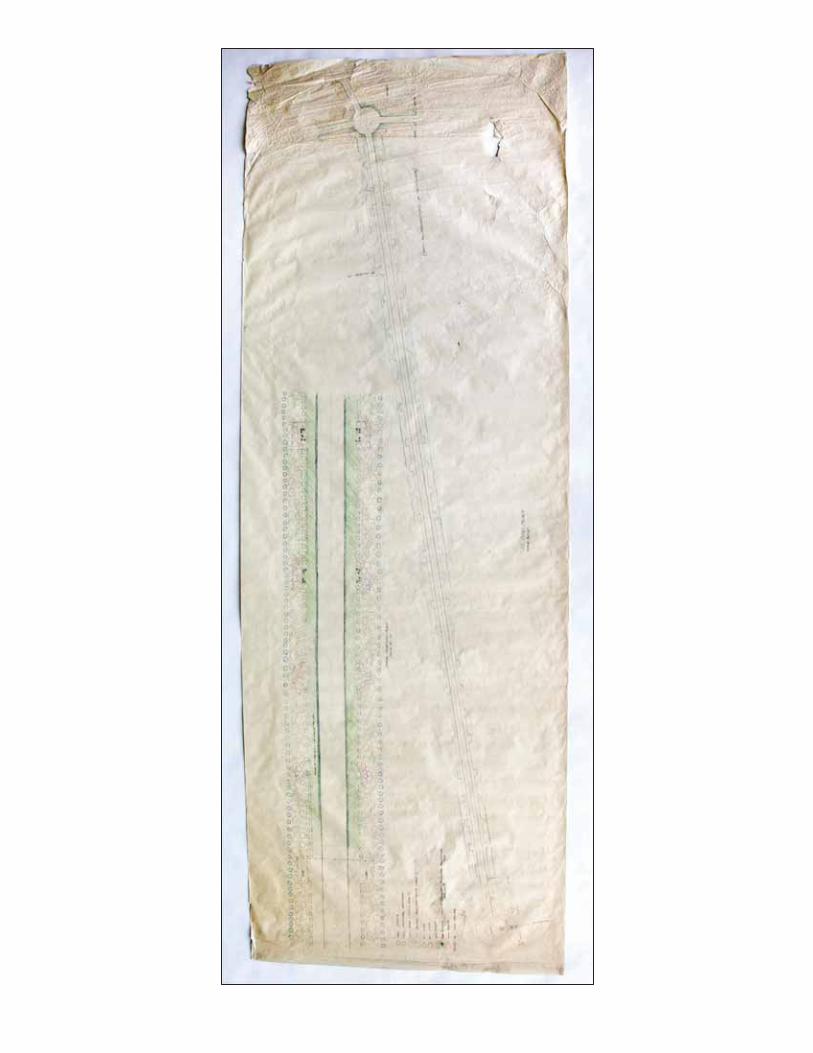

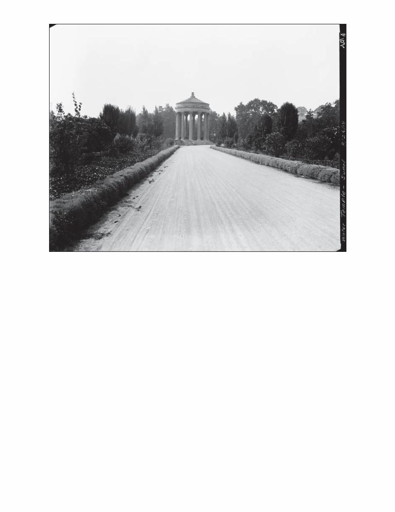

APPENDIX B
Construction Equipment Estimates


1
T E C H N I C A L M E M O R A N D U M CS-128A, Task Order No. 3 – Sunol Long Term Improvements Project
Estimated Equipment Usage During Construction PREPARED FOR: SFPUC Engineering Management Bureau
PREPARED BY: Kennedy/Jenks Consultants | Water Resources Engineering
DATE: August 14, 2012 UPDATED: August 21, 2013 (SFPUC & CCSF DPW)
IntroductionBackground The SFPUC Sunol Long Term Improvements Project is composed of two separate elements: improvements to the existing Sunol Yard and development of a new interpretative center, the Alameda Creek Watershed Center. The Sunol Yard provides a base from which Water Supply and Treatment Division staff can manage, maintain, and control east bay operations. The Watershed Center is a new facility that will serve as an exhibit area for visitors to the Sunol Water Temple while housing historical displays of the San Francisco water system, the Sunol Valley, and the local ecology.
The Sunol Yard will be reconfigured to improve efficiency of operations. With the exception of existing pre-fabricated maintenance shops and the Town of Sunol pump station, the other buildings within the yard will be demolished and replaced by new structures. Two new shops (electrical/plumbing shop and electronic maintenance technicians [EMT]/radio shop) and several new covered storage structures will be incorporated into the yard layout. New above-ground fuel tanks will be installed at a relocated fueling station. Security fencing will be provided along the perimeter of the yard.
The Watershed Center will be constructed in the vicinity of the Sunol Temple. An accessible parking lot will serve the center. The area around the entrance gate as well as the temple road will be rehabilitated. Landscaping will be installed along the temple road and the area surrounding the Watershed Center.
A Conceptual Engineering Report (CER) was prepared by the SFPUC for the Sunol Long Term Improvements Project. The CER provides design guidelines and establishes basic requirements for each facility within the Sunol Yard and Watershed Center.
ScopeEMB requested the development of construction schedules and equipment usage estimates for the construction of the Sunol Long Term Improvements Project. The construction schedules were to include only basic construction activities, with sufficient detail to allow the estimating of equipment usage. Details on planned construction activities were provided
K/JC
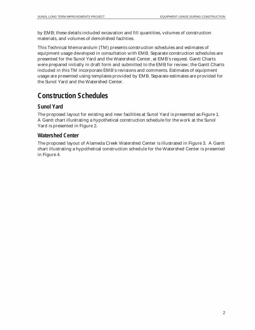
SUNOL LONG TERM IMPROVEMENTS PROJECT EQUIPMENT USAGE DURING CONSTRUCTION
2
by EMB; these details included excavation and fill quantities, volumes of construction materials, and volumes of demolished facilities.
This Technical Memorandum (TM) presents construction schedules and estimates of equipment usage developed in consultation with EMB. Separate construction schedules are presented for the Sunol Yard and the Watershed Center, at EMB’s request. Gantt Charts were prepared initially in draft form and submitted to the EMB for review; the Gantt Charts included in this TM incorporate EMB’s revisions and comments. Estimates of equipment usage are presented using templates provided by EMB. Separate estimates are provided for the Sunol Yard and the Watershed Center.
Construction Schedules Sunol Yard The proposed layout for existing and new facilities at Sunol Yard is presented as Figure 1. A Gantt chart illustrating a hypothetical construction schedule for the work at the Sunol Yard is presented in Figure 2.
Watershed Center The proposed layout of Alameda Creek Watershed Center is illustrated in Figure 3. A Gantt chart illustrating a hypothetical construction schedule for the Watershed Center is presented in Figure 4.
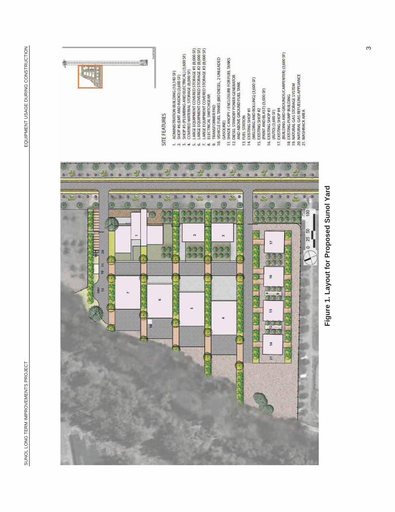
SUN
OL
LON
G T
ERM
IMPR
OVE
MEN
TS P
RO
JEC
T EQ
UIP
MEN
T U
SAG
E D
UR
ING
CO
NS
TRU
CTI
ON
3
Figu
re 1
. Lay
out f
or P
ropo
sed
Suno
l Yar
d
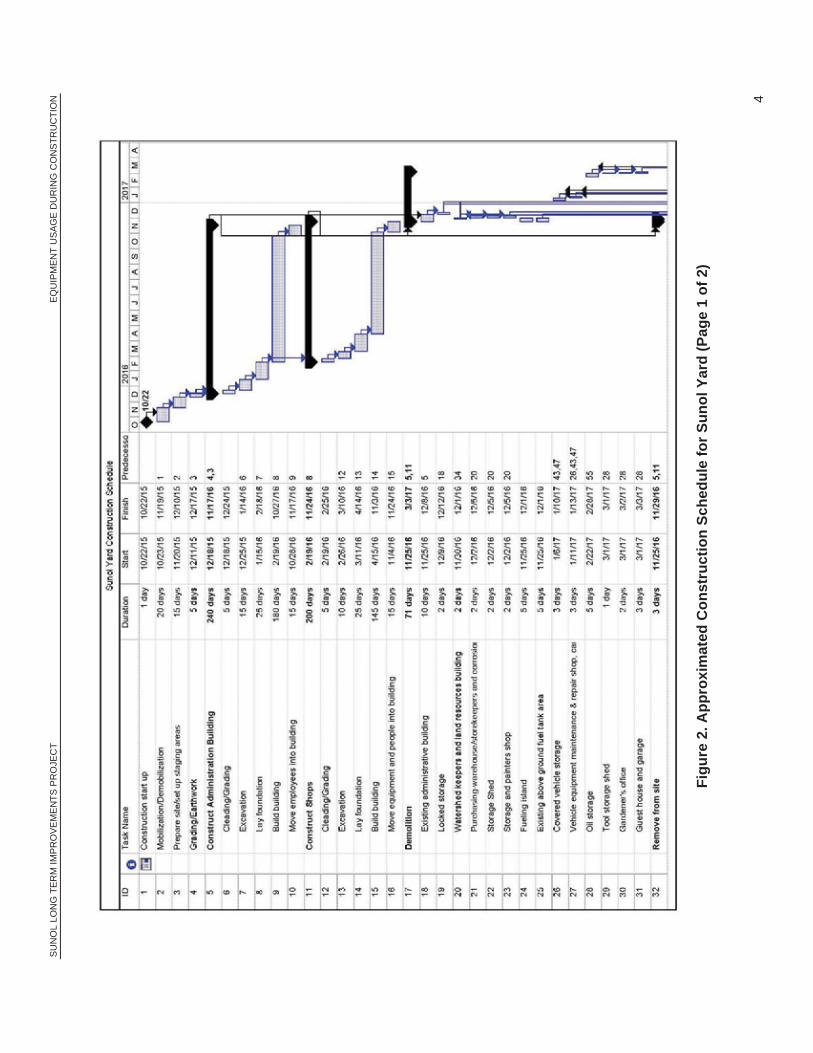
SUN
OL
LON
G T
ERM
IMPR
OVE
MEN
TS P
RO
JEC
T EQ
UIP
MEN
T U
SAG
E D
UR
ING
CO
NS
TRU
CTI
ON
4
Fi
gure
2. A
ppro
xim
ated
Con
stru
ctio
n Sc
hedu
le fo
r Sun
ol Y
ard
(Pag
e 1
of 2
)

SUN
OL
LON
G T
ERM
IMPR
OVE
MEN
TS P
RO
JEC
T EQ
UIP
MEN
T U
SAG
E D
UR
ING
CO
NS
TRU
CTI
ON
5
Fi
gure
2. A
ppro
xim
ated
Con
stru
ctio
n Sc
hedu
le fo
r Sun
ol Y
ard
(Pag
e 2
of 2
)
SUN
OL
LON
G T
ERM
IMPR
OVE
MEN
TS P
RO
JEC
T EQ
UIP
MEN
T U
SAG
E D
UR
ING
CO
NS
TRU
CTI
ON
6
Fi
gure
3. L
ayou
t for
Pro
pose
d A
lam
eda
Cre
ek W
ater
shed
Cen
ter

SUN
OL
LON
G T
ERM
IMPR
OVE
MEN
TS P
RO
JEC
T EQ
UIP
MEN
T U
SAG
E D
UR
ING
CO
NS
TRU
CTI
ON
7
Fi
gure
4. A
ppro
xim
ated
Con
stru
ctio
n Sc
hedu
le fo
r Ala
med
a C
reek
Wat
ersh
ed C
ente
r

SUNOL LONG TERM IMPROVEMENTS PROJECT EQUIPMENT USAGE DURING CONSTRUCTION
8
Estimated Equipment Usage Sunol Yard Equipment usage was estimated in conjunction with information provided by EMB. Where information was not available, assumptions were made and verified with EMB. Estimates and assumptions include the following:
Estimated demolition volume: It estimated the removal of existing structures will produce approximately 2,000 cubic yards of demolished building materials.
Off-site material disposal and recycling sites: It is anticipated that materials will be disposed of or recycled, consistent with applicable regulations, at appropriate facilities accessed via Interstate 680 (project vehicles assumed to use Paloma Way to I-680).
Hazardous materials removed during demolition: Any hazardous materials, including asbestos, encountered during demolition will be contained, transported, and disposed of in accordance with applicable regulations.
Cut and fill quantities for earthwork, including necessary soil imports:
Sunol Yard Estimated Cut and Fill Quantities
Item Volume
(cubic yards)
Imported material 7,000
Excavated material 20,000
Excavated material to be reused at Sunol Yard 6,000
Surplus excavated materials 14,000
Portion for offsite disposal (value for planning purposes only) 4,000
Excavated material to be reused at Watershed Center 10,000
0
Volume of concrete: It estimated that approximately 2,600 cubic yards of concrete will be required (for foundations, etc.).
Required space for staging: An area of 3,000 square feet was estimated for staging.
Material storage needs: Anticipated to be onsite (offsite storage not assumed).
Lead periods for material acquisition: None anticipated at this time.

SUNOL LONG TERM IMPROVEMENTS PROJECT EQUIPMENT USAGE DURING CONSTRUCTION
9
Average and maximum number of workers at various stages of construction:
Estimated Number of Construction Workers at the Sunol Yard
Construction Phase Average per
Day Maximum
Administrative building construction 12 18
Construction of shops 10 15
Demolition of existing facilities 8 14
Construction of fuel tank site 5 8
Installation of generator and transformer 5 8
Construction of storage areas 7 10
Landscaping/Paving 5 8
Power generation needs during construction: It is estimated that a temporary 150 kilowatt generator will used for intermittent peak demands during construction. Additional details presented in Appendix A.
Estimated construction equipment: Estimated equipment types are presented in Appendix A.
Busiest day during construction: It is estimated that the busiest day during construction will involve 10 units of equipment operating concurrently.
For each of the primary phases of construction at Sunol Yard, a table of estimated construction equipment usage is presented in Appendix A.
Watershed Center Equipment usage was estimated in conjunction with information provided by EMB. Where information was not available, assumptions were made and verified with EMB. Estimates and assumptions include the following:
Demolition volumes: None.
Cut and fill quantities for earthwork, including necessary soil imports:
Watershed Center Estimated Cut and Fill Quantities
Item Volume
(cubic yards)
Excavated material (and reused onsite) 500
Imported material (i.e., reused) from Sunol Yard 10,000
Volumes of concrete: Approximately 900 cubic yards.
Required space for staging: Approximately 1,500 square feet is assumed for staging.
Material storage needs: Anticipated to be onsite (offsite storage not assumed).
Lead periods for material acquisition: None anticipated at this time.

SUNOL LONG TERM IMPROVEMENTS PROJECT EQUIPMENT USAGE DURING CONSTRUCTION
10
Average and maximum number of workers at various stages of construction:
Estimated Number of Construction Workers at the Watershed Center Construction Phase Average per Day Maximum
Construction of building 10 14
Landscaping/Paving/displays 10 14
Power generation needs during construction: It is estimated that a temporary 150 kilowatt generator will used for intermittent peak demands during construction. Additional details presented in Appendix B.
Estimated construction equipment: Estimated equipment types are presented in Appendix B.
Busiest day during construction: It is estimated that the busiest day during construction will involve 8 units of equipment operating concurrently.
For each of the primary phases of construction at the Watershed Center, a table of estimated construction equipment usage is presented in Appendix B.

SUNOL LONG TERM IMPROVEMENTS PROJECT EQUIPMENT USAGE DURING CONSTRUCTION
APPENDIX A (Tables A-1 through A-7)

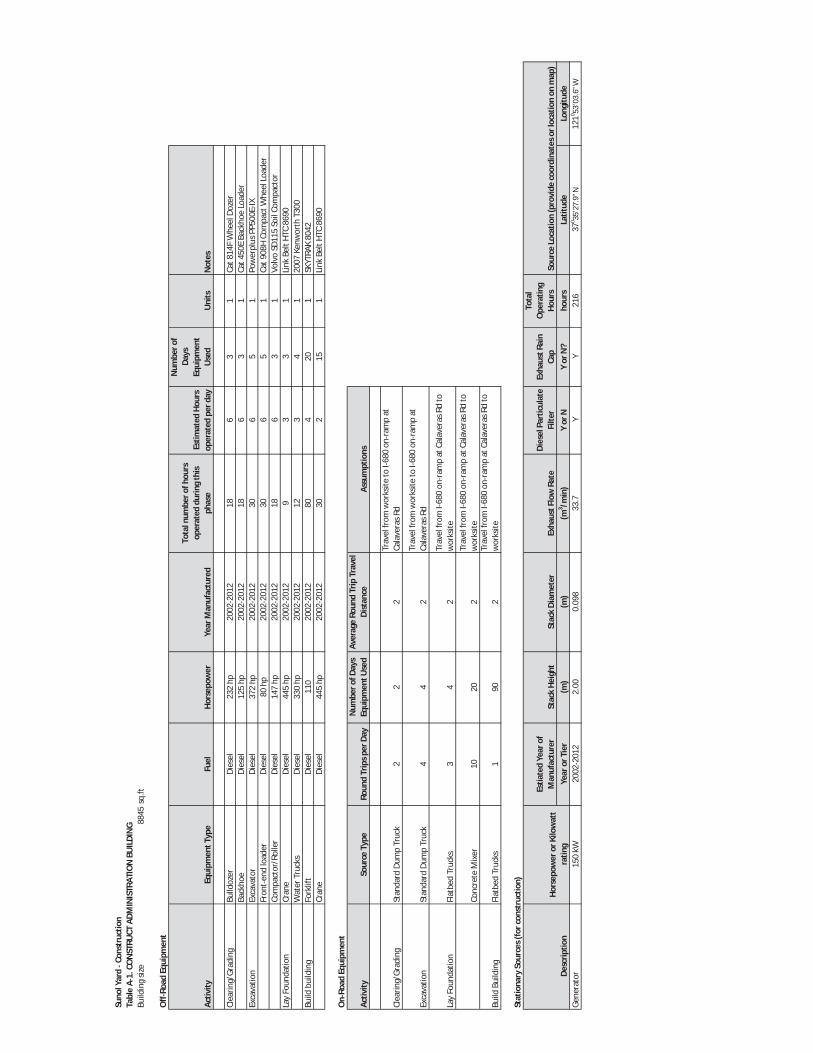
Suno
lYar
dCo
nstr
uctio
nTa
ble
A1.
CON
STRU
CTAD
MIN
ISTR
ATIO
NBU
ILDI
NG
Build
ing
size
8845
sq.ft
Off
Road
Equi
pmen
t
Activ
ityEq
uipm
entT
ype
Fuel
Hors
epow
erYe
arM
anuf
actu
red
Tota
lnum
bero
fhou
rsop
erat
eddu
ring
this
phas
eEs
timat
edHo
urs
oper
ated
perd
ay
Num
bero
fDa
ysEq
uipm
ent
Use
dU
nits
Not
es
Clea
ring/
Grad
ing
Bulld
ozer
Dies
el23
2hp
2002
2012
186
31
Cat8
14F
Whe
elDo
zer
Back
hoe
Dies
el12
5hp
2002
2012
186
31
Cat4
50E
Back
hoe
Load
erEx
cava
tion
Exca
vato
rDi
esel
372
hp20
0220
1230
65
1Po
wer
plus
PP50
0EIX
Fron
ten
dlo
ader
Dies
el80
hp20
0220
1230
65
1Ca
t908
HCo
mpa
ctW
heel
Load
erCo
mpa
ctor
/Rol
ler
Dies
el14
7hp
2002
2012
186
31
Volv
oSD
115
Soil
Com
pact
orLa
yFo
unda
tion
Cran
eDi
esel
445
hp20
0220
129
33
1Li
nkBe
ltHT
C86
90W
ater
Truc
ksDi
esel
330
hp20
0220
1212
34
120
07Ke
nwor
thT3
00Bu
ildbu
ildin
gFo
rklif
tDi
esel
110
2002
2012
804
201
SKYT
RAK
8042
Cran
eDi
esel
445
hp20
0220
1230
215
1Li
nkBe
ltHT
C86
90
On
Road
Equi
pmen
t
Activ
itySo
urce
Type
Roun
dTr
ipsp
erDa
yN
umbe
rofD
ays
Equi
pmen
tUse
dAv
erag
eRo
und
Trip
Trav
elDi
stan
ce
Clea
ring/
Grad
ing
Stan
dard
Dum
pTr
uck
22
2
Exca
vatio
nSt
anda
rdDu
mp
Truc
k4
42
Lay
Foun
datio
nFl
atbe
dTr
ucks
34
2
Conc
rete
Mix
er10
202
Build
Build
ing
Flat
bed
Truc
ks1
902
Stat
iona
rySo
urce
s(fo
rcon
stru
ctio
n)
Estia
ted
Year
ofM
anuf
actu
rer
Stac
kHe
ight
Stac
kDi
amet
erEx
haus
tFlo
wRa
teDi
esel
Part
icul
ate
Filte
rEx
haus
tRai
nCa
p
Tota
lO
pera
ting
Hour
sYe
aror
Tier
(m)
(m)
(m3 /m
in)
Yor
NY
orN
?ho
urs
Latit
ude
Long
itude
Gene
rato
r15
0kW
2002
2012
2.00
0.09
833
.7Y
Y21
637
0 35’2
7.9”
N12
10 53’0
3.6”
W
Assu
mpt
ions
Trav
elfr
omw
orks
iteto
I680
onra
mp
atCa
lave
rasR
d
Sour
ceLo
catio
n(p
rovi
deco
ordi
nate
sorl
ocat
ion
onm
ap)
Desc
riptio
nHo
rsep
ower
orKi
low
att
ratin
g
Trav
elfr
omw
orks
iteto
I680
onra
mp
atCa
lave
rasR
d
Trav
elfr
omI6
80on
ram
pat
Cala
vera
sRd
tow
orks
ite
Trav
elfr
omI6
80on
ram
pat
Cala
vera
sRd
tow
orks
iteTr
avel
from
I680
onra
mp
atCa
lave
rasR
dto
wor
ksite


Suno
lYar
dCo
nstr
uctio
nTa
ble
A2.
CON
STRU
CTSH
OPS
Build
ing
size
7200
sq.ft
Off
Road
Equi
pmen
t
Activ
ityEq
uipm
entT
ype
Fuel
Hors
epow
erYe
arM
anuf
actu
red
Tota
lnum
bero
fhou
rsop
erat
eddu
ring
this
phas
eEs
timat
edHo
urs
oper
ated
perd
ayN
umbe
rofD
ays
Equi
pmen
tUse
dU
nits
Not
es
Clea
ring/
Grad
ing
Bulld
ozer
Dies
el23
2hp
2002
2012
306
51
Cat8
14F
Whe
elDo
zer
Back
hoe
Dies
el12
5hp
2002
2012
306
51
Cat4
50E
Back
hoe
Load
erEx
cava
tion
Exca
vato
rDi
esel
372
hp20
0220
1220
45
1Po
wer
plus
PP50
0EIX
Fron
ten
dlo
ader
Dies
el80
hp20
0220
1224
46
1Ca
t908
HCo
mpa
ctW
heel
Load
erCo
mpa
ctor
/Rol
ler
Dies
el14
7hp
2002
2012
306
51
Volv
oSD
115
Lay
Foun
datio
nCr
ane
Dies
el44
5hp
2002
2012
402
201
Link
Belt
HTC
8690
Wat
erTr
ucks
Dies
el33
0hp
2002
2012
603
102
2007
Kenw
orth
T300
Build
build
ing
Cran
eDi
esel
445
hp20
0220
1220
120
1Li
nkBe
ltHT
C86
90Fo
rklif
tDi
esel
110
2002
2012
602
301
SKYT
RAK
8042
On
Road
Equi
pmen
t
Activ
itySo
urce
Type
Roun
dTr
ipsp
erDa
yN
umbe
rofD
ays
Equi
pmen
tUse
dAv
erag
eRo
und
Trip
Trav
elDi
stan
ceAs
sum
ptio
ns
Clea
ring/
Grad
ing
Stan
dard
Dum
pTr
uck
(Cat
CT11
)2
22
Exca
vatio
nSt
anda
rdDu
mp
Truc
k(C
atCT
11)
22
2
Lay
Foun
datio
nFl
atbe
dTr
uck
12
2
Conc
rete
Mix
er4
22
Build
Build
ing
Flat
bed
Truc
ks1
452
Stat
iona
rySo
urce
s(fo
rcon
stru
ctio
n)Ho
rsep
ower
orKi
low
att
ratin
gEs
tiate
dYe
arof
Man
ufac
ture
rSt
ack
Heig
htSt
ack
Diam
eter
Exha
ustF
low
Rate
Exha
ustT
emp
Exha
ustR
ain
Cap
Tota
lOpe
ratin
gHo
urs
Year
orTi
er(m
)(m
)(m
3 /min
)Y
orN
?ho
urs
Gene
rato
r15
0kW
2002
2012
2.00
0.09
833
.780
6F
Y32
Trav
elfr
omw
orks
iteto
I680
onra
mp
atCa
lave
ras
Rd
Desc
riptio
n
Trav
elfr
omw
orks
iteto
I680
onra
mp
atCa
lave
ras
Rd Trav
elfr
omI6
80on
ram
pat
Cala
vera
sRd
tow
orks
ite
Trav
elfr
omTr
avel
from
I680
onra
mp
atCa
lave
ras
Rdto
wor
ksite
Trav
elfr
omTr
avel
from
I680
onra
mp
atCa
lave
ras
Rdto
wor
ksite


Suno
lYar
dCo
nstr
uctio
nTa
ble
A3.
DEM
OLI
TIO
NBu
ildin
gsiz
eVa
ries
sq.ft
Off
Road
Equi
pmen
t
Activ
ityEq
uipm
entT
ype
Fuel
Hors
epow
erYe
arM
anuf
actu
red
Tota
lnum
bero
fhou
rsop
erat
eddu
ring
this
phas
eEs
timat
edHo
urso
pera
ted
perd
ayN
umbe
rofD
ays
Equi
pmen
tUse
dU
nits
Not
es
Clea
ring
Bulld
ozer
Dies
el23
2hp
2002
2012
906
151
Cat8
14F
Whe
elDo
zer
Back
hoe
Dies
el12
5hp
2002
2012
906
151
Cat4
50E
Back
hoe
Load
erCr
ane
Dies
el44
5hp
2002
2012
302
151
Link
Belt
HTC
8690
Saw
cutt
ing
Mac
hine
Elec
tic10
020
0220
1218
06
301
saw
cutt
ing
mac
hine
s
On
Road
Equi
pmen
t
Activ
itySo
urce
Type
Roun
dTr
ipsp
erDa
yN
umbe
rofD
ays
Equi
pmen
tUse
dAv
erag
eRo
und
Trip
Trav
elDi
stan
ce
Clea
ring
Stan
dard
Dum
pTr
uck
(Cat
CT11
)3
152
Assu
mpt
ions
Trav
elfr
omw
orks
iteto
I680
onra
mp
atCa
lave
rasR
d


Suno
lYar
dCo
nstr
uctio
nTa
ble
A4.
CON
STRU
CTTA
NK
AREA
#1,#
2&
ABO
VEGR
OU
ND
FUEL
TAN
KAR
E A
Off
Road
Equi
pmen
t
Activ
ityEq
uipm
entT
ype
Fuel
Hors
epow
erYe
arM
anuf
actu
red
Tota
lnum
bero
fhou
rsop
erat
eddu
ring
this
phas
eEs
timat
edHo
urso
pera
ted
perd
ayN
umbe
rofD
ays
Equi
pmen
tUse
dU
nits
Not
es
Clea
ring/
Grad
ing
Bulld
ozer
Dies
el23
2hp
2002
2012
126
21
Cat8
14F
Whe
elDo
zer
Back
hoe
Dies
el12
5hp
2002
2012
186
31
Cat4
50E
Back
hoe
Load
erCo
mpa
ctor
/Rol
ler
Dies
el14
7hp
2002
2012
186
31
Volv
oSD
115
Soil
Com
pact
orW
ater
Truc
ksDi
esel
330
hp20
0220
129
33
120
07Ke
nwor
thT3
00La
yFo
unda
tion
Cran
eDi
esel
445
hp20
0220
128
42
1Li
nkBe
ltHT
C86
90In
stal
ltan
ksCr
ane
Dies
el44
5hp
2002
2012
84
21
Link
Belt
HTC
8690
On
Road
Equi
pmen
t
Activ
itySo
urce
Type
Roun
dTr
ipsp
erDa
yN
umbe
rofD
ays
Equi
pmen
tUse
d
Aver
age
Roun
dTr
ipTr
avel
Dist
ance
Clea
ring/
Grad
ing
Stan
dard
Dum
pTr
uck
(Cat
CT11
)2
12
Lay
Foun
datio
nCo
ncre
teM
ixer
12
2
Mov
eeq
uipm
ent/
inst
all
Flat
bed
Truc
ks1
42
Trav
elfr
omw
orks
iteto
I680
onra
mp
atCa
lave
rasR
d
Trav
elfr
omI6
80on
ram
pat
Cala
vera
sRd
tow
orks
ite
Off
Road
Equi
pmen
t
Assu
mpt
ions
Trav
elfr
omw
orks
iteto
I680
onra
mp
atCa
lave
rasR
d

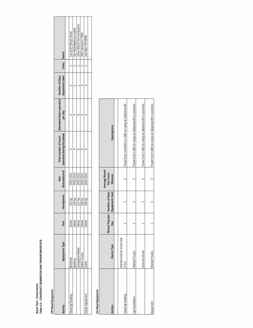
Suno
lYar
dCo
nstr
uctio
nTa
ble
A5.
CON
STRU
CTGE
NER
ATO
RAN
DTR
ANSF
ORM
ERSI
TE
Off
Road
Equi
pmen
t
Activ
ityEq
uipm
entT
ype
Fuel
Hors
epow
erYe
arM
anuf
actu
red
Tota
lnum
bero
fhou
rsop
erat
eddu
ring
this
phas
eEs
timat
edHo
urso
pera
ted
perd
ayN
umbe
rofD
ays
Equi
pmen
tUse
dU
nits
Not
es
Clea
ring/
Grad
ing
Bulld
ozer
Dies
el23
2hp
2002
2012
44
11
Cat8
14F
Whe
elDo
zer
Back
hoe
Dies
el12
5hp
2002
2012
44
11
Cat4
50E
Back
hoe
Load
erCo
mpa
ctor
/Rol
ler
Dies
el14
7hp
2002
2012
55
11
Volv
oSD
115
Soil
Com
pact
orW
ater
Truc
ksDi
esel
330
hp20
0220
128
24
120
07Ke
nwor
thT3
00In
stal
lequ
ipm
ent
Cran
eDi
esel
445
hp20
0220
126
23
1Li
nkBe
ltHT
C86
90
On
Road
Equi
pmen
t
Activ
itySo
urce
Type
Roun
dTr
ipsp
erDa
yN
umbe
rofD
ays
Equi
pmen
tUse
d
Aver
age
Roun
dTr
ipTr
avel
Dist
ance
Clea
ring/
Grad
ing
Stan
dard
Dum
pTr
uck
(Cat
CT11
)1
12
Lay
foun
datio
nFl
atbe
dTr
ucks
11
2
Conc
rete
Mix
er1
12
Equi
pmen
tFl
atbe
dTr
ucks
14
2
Assu
mpt
ions
Trav
elfr
omw
orks
iteto
I680
onra
mp
atCa
lave
rasR
d
Trav
elfr
omI6
80on
ram
pat
Cala
vera
sRd
tow
orks
ite
Trav
elfr
omI6
80on
ram
pat
Cala
vera
sRd
tow
orks
ite
Trav
elfr
omI6
80on
ram
pat
Cala
vera
sRd
tow
orks
ite


Suno
lYar
dCo
nstr
uctio
nTa
ble
A6.
CON
STRU
CTST
ORA
GEAR
EAS
Build
ing
size
Varie
ssq
.ft
Off
Road
Equi
pmen
t
Activ
ityEq
uipm
entT
ype
Fuel
Hors
epow
erYe
arM
anuf
actu
red
Tota
lnum
bero
fhou
rsop
erat
eddu
ring
this
phas
eEs
timat
edHo
urso
pera
ted
perd
ayN
umbe
rofD
ays
Equi
pmen
tUse
dU
nits
Not
es
Clea
ring/
Grad
ing
Bulld
ozer
Dies
el23
2hp
2002
2012
246
41
Cat8
14F
Whe
elDo
zer
Back
hoe
Dies
el12
5hp
2002
2012
306
51
Cat4
50E
Back
hoe
Load
erCo
mpa
ctor
/Rol
ler
Dies
el34
540
1hp
2002
2012
246
41
Volv
oSD
115
Soil
Com
pact
orW
ater
Truc
ksDi
esel
330
hp20
0220
1215
35
120
07Ke
nwor
thT3
00La
yFo
unda
tion
Cran
eDi
esel
445
hp20
0220
126
32
1Li
nkBe
ltHT
C86
90Sa
wcu
ttin
gM
achi
neEl
ectic
100
2002
2012
486
81
saw
cutt
ing
mac
hine
Build
stru
ctur
esCr
ane
Dies
el44
5hp
2002
2012
303
101
Link
Belt
HTC
8690
Fork
lift
Dies
el11
0hp
2002
2012
303
101
SKYT
RAK
8042
On
Road
Equi
pmen
t
Activ
itySo
urce
Type
Roun
dTr
ipsp
erDa
yN
umbe
rofD
ays
Equi
pmen
tUse
dAv
erag
eRo
und
Trip
Trav
elDi
stan
ce
Clea
ring/
Grad
ing
Stan
dard
Dum
pTr
uck
(Cat
CT11
)2
22
Lay
Foun
datio
nFl
atbe
dTr
ucks
21
2
Conc
rete
Mix
er2
42
Build
Stru
ctur
esFl
atbe
dTr
ucks
125
2
Stat
iona
rySo
urce
s(fo
rcon
stru
ctio
n)
Estia
ted
Year
ofM
anuf
actu
rer
Stac
kHe
ight
Stac
kDi
amet
erEx
haus
tFlo
wRa
teEx
haus
tTem
pDi
esel
Part
icul
ate
Filte
rDP
FEf
ficie
ncy
Exha
ustR
ain
Cap
Tota
lOpe
ratin
gHo
urs
Year
orTi
er(m
)(m
)(m
3 /min
)Y
orN
%Y
orN
?ho
urs
Latit
ude
Long
itude
Gene
rato
r15
0kW
2002
2012
2.00
00.
098
33.7
806
FY
98Y
8037
0 35’2
7.9”
N12
10 53’0
3.6”
W
Assu
mpt
ions
Sour
ceLo
catio
n(p
rovi
deco
ordi
nate
sor
loca
tion
onm
ap)
Desc
riptio
nHo
rsep
ower
orKi
low
attr
atin
g
Trav
elfr
omI6
80on
ram
pat
Cala
vera
sRd
tow
orks
iteTr
avel
from
I680
onra
mp
atCa
lave
rasR
dto
wor
ksite
Trav
elfr
omI6
80on
ram
pat
Cala
vera
sRd
tow
orks
iteTr
avel
from
I680
onra
mp
atCa
lave
rasR
dto
wor
ksite

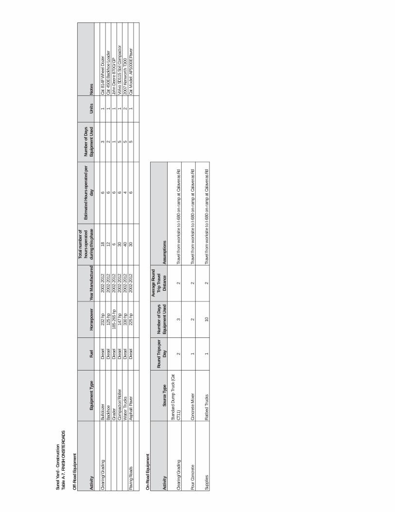
Suno
lYar
dCo
nstr
uctio
nTa
ble
A7.
FIN
ISH
ON
SITE
ROAD
S
Off
Road
Equi
pmen
t
Activ
ityEq
uipm
entT
ype
Fuel
Hors
epow
erYe
arM
anuf
actu
red
Tota
lnum
bero
fho
urso
pera
ted
durin
gth
isph
ase
Estim
ated
Hour
sope
rate
dpe
rda
yN
umbe
rofD
ays
Equi
pmen
tUse
dU
nits
Not
es
Clea
ring/
Grad
ing
Bulld
ozer
Dies
el23
2hp
2002
2012
186
31
Cat8
14F
Whe
elDo
zer
Back
hoe
Dies
el12
5hp
2002
2012
126
21
Cat4
50E
Back
hoe
Load
erGr
ader
Dies
el18
526
5hp
2002
2012
66
11
John
Deer
e87
0G/G
PCo
mpa
ctor
/Rol
ler
Dies
el14
7hp
2002
2012
306
51
Volv
oSD
115
Soil
Com
pact
orW
ater
Truc
ksDi
esel
330
hp20
0220
1240
45
220
07Ke
nwor
thT3
00Pa
ving
Road
sAs
phal
tPav
erDi
esel
225
hp20
0220
1230
65
1Ca
tMod
el:A
P100
0EPa
ver
On
Road
Equi
pmen
t
Activ
itySo
urce
Type
Roun
dTr
ipsp
erDa
yN
umbe
rofD
ays
Equi
pmen
tUse
d
Aver
age
Roun
dTr
ipTr
avel
Dist
ance
Assu
mpt
ions
Clea
ring/
Grad
ing
Stan
dard
Dum
pTr
uck
(Cat
CT11
)2
32
Pour
Conc
rete
Conc
rete
Mix
er1
22
Supp
lies
Flat
bed
Truc
ks1
102
Trav
elfr
omw
orks
iteto
I680
onra
mp
atCa
lave
rasR
d
Trav
elfr
omw
orks
iteto
I680
onra
mp
atCa
lave
rasR
d
Trav
elfr
omw
orks
iteto
I680
onra
mp
atCa
lave
rasR
d


SUNOL LONG TERM IMPROVEMENTS PROJECT EQUIPMENT USAGE DURING CONSTRUCTION
APPENDIX B (Tables B-1 and B-2)


Wat
ersh
edCe
nter
Cons
truc
tion
Tabl
eB
1.CO
NST
RUCT
BUIL
DIN
G
Off
Road
Equi
pmen
t
Phas
eEq
uipm
entT
ype
Fuel
Hors
epow
erYe
arM
anuf
actu
red
Tota
lnum
bero
fhou
rsop
erat
eddu
ring
this
phas
eEs
timat
edHo
urso
pera
ted
perd
ayN
umbe
rofD
ays
Equi
pmen
tUse
dU
nits
Not
es
Clea
ring/
Grad
ing
Bulld
ozer
Dies
el23
2hp
2002
2012
606
101
Cat8
14F
Whe
elDo
zer
Tran
sfer
Dum
pTr
uck
Dies
el41
550
5hp
2002
2012
500
821
3M
ack
MP8
truc
kBa
ckho
eDi
esel
125
hp20
0220
1230
65
1Ca
t450
EBa
ckho
eLo
ader
Grad
erDi
esel
185
265
hp20
0220
1230
65
1Jo
hnDe
ere
870G
/GP
Com
pact
or/R
olle
rDi
esel
147
hp20
0220
1290
615
1Vo
lvo
SD11
5So
ilCo
mpa
ctor
Exca
vato
rDi
esel
372
hp20
0220
1260
610
1Po
wer
plus
PP50
0EIX
Fron
ten
dlo
ader
Dies
el80
hp20
0220
1260
610
1Ca
t908
HCo
mpa
ctW
heel
Load
erW
ater
Truc
ksDi
esel
330
hp20
0220
1240
410
120
07Ke
nwor
thT3
00La
yFo
unda
tion
Cran
eDi
esel
445
hp20
0220
1230
65
1Li
nkBe
ltHT
C86
90W
ater
Truc
ksDi
esel
330
hp20
0220
1240
410
120
07Ke
nwor
thT3
00Bu
ildBu
ildin
gCr
ane
Dies
el44
5hp
2002
2012
453
151
Link
Belt
HTC
8690
Fork
lift
Dies
el11
0hp
2002
2012
903
301
SKYT
RAK
8042
Phas
eSo
urce
Type
Tota
lRou
ndTr
ips
perD
ayN
umbe
rofD
ays
Equi
pmen
tUse
d
Aver
age
Roun
dTr
ipTr
avel
Dist
ance
Clea
ring/
Grad
ing
Tran
sfer
Dum
pTr
uck
Lay
Foun
datio
nFl
atbe
dTr
ucks
25
2
Conc
rete
Mix
er10
102
Build
Build
ing
Flat
bed
Truc
ks2
602
Mov
ein
furn
iture
Furn
iture
Truc
k2
22
Stat
iona
rySo
urce
sSt
atio
nary
Sour
ces(
forc
onst
ruct
ion)
Estia
ted
Year
ofM
anuf
actu
rer
Stac
kHe
ight
Stac
kDi
amet
erEx
haus
tFlo
wRa
teEx
haus
tTem
pDi
esel
Part
icul
ate
Filte
rDP
FEf
ficie
ncy
Exha
ustR
ain
Cap
Tota
lO
pera
ting
Hour
sYe
aror
Tier
(m)
(m)
(m3 /m
in)
Yor
N%
Yor
N?
hour
sLa
titud
eLo
ngitu
deGe
nera
tor
150
kW20
0220
122.
000.
098
33.7
806
FY
98Y
120
370 35
’27.
9”N
1210 53
’03.
6”W
Sour
ceLo
catio
n(p
rovi
deco
ordi
nate
sor
loca
tion
onm
ap)
Trav
elfr
omw
orks
iteto
I680
onra
mp
atCa
lave
rasR
d
Trav
elfr
omw
orks
iteto
I680
onra
mp
atCa
lave
rasR
d
Trav
elfr
omw
orks
iteto
I680
onra
mp
atCa
lave
rasR
d
Trav
elso
nsite
sono
ted
abov
eun
derO
ffRo
adEq
mt.
Desc
riptio
nHo
rsep
ower
orKi
low
attr
atin
g
On
Road
Equi
pmen
t
Trav
elfr
omw
orks
iteto
I680
onra
mp
atCa
lave
rasR
d
Assu
mpt
ions

Wat
ersh
edCe
nter
Cons
truc
tion
Tabl
eB
2.LA
NDS
CAPI
NG/
PAVI
NG/
DISP
LAYS
Off
Road
Equi
pmen
t
Phas
eEq
uipm
entT
ype
Fuel
Hors
epow
erYe
arM
anuf
actu
red
Tota
lnum
bero
fhou
rsop
erat
eddu
ring
this
phas
eEs
timat
edHo
urso
pera
ted
perd
ayN
umbe
rofD
ays
Equi
pmen
tUse
dU
nits
Not
es
Clea
ring/
Grad
ing
Bulld
ozer
Dies
el23
2hp
2002
2012
186
31
Cat8
14F
Whe
elDo
zer
Back
hoe
Dies
el12
5hp
2002
2012
120
62
1Ca
t450
EBa
ckho
eLo
ader
Grad
erDi
esel
185
265
hp20
0220
1211
46
11
John
Deer
e87
0G/G
PCo
mpa
ctor
/Rol
ler
Dies
el14
7hp
2002
2012
114
65
1Vo
lvo
SD11
5So
ilCo
mpa
ctor
Wat
erTr
ucks
Dies
el33
0hp
2002
2012
240
45
120
07Ke
nwor
thT3
00Pa
ving
Road
sAs
phal
tPav
erDi
esel
225
hp20
0220
1212
06
51
CatM
odel
:AP1
000E
Pave
r
Phas
eSo
urce
Type
Tota
lRou
ndTr
ipsp
erDa
yN
umbe
rofD
ays
Equi
pmen
tUse
dAv
erag
eRo
und
Trip
Trav
elDi
stan
ce
Clea
ring/
Grad
ing
Stan
dard
Dum
pTr
uck
(Cat
CT11
)2
22
Pour
Conc
rete
Conc
rete
Mix
er2
22
Supp
lies
Flat
bed
Truc
ks1
52
Trav
elfr
omw
orks
iteto
I680
onra
mp
atCa
lave
rasR
d
Trav
elfr
omw
orks
iteto
I680
onra
mp
atCa
lave
rasR
d
Assu
mpt
ions
Trav
elfr
omw
orks
iteto
I680
onra
mp
atCa
lave
rasR
d
On
Road
Equi
pmen
t
APPENDIX C
Biological Resources


C-1
A
PPEN
DIX
CSP
ECIA
L ST
ATU
S SP
ECIE
S PO
TEN
TIA
LLY
OC
CU
RIN
G IN
TH
E PR
OJE
CT
VIC
INIT
Y
Scie
ntif
ic N
ame
Com
mon
Nam
e
Fede
ral
Stat
us
Stat
e St
atus
CN
PS
List
ing
H
abita
t Des
crip
tion
/ Blo
omin
g Pe
riod
Po
tent
ial t
o O
ccur
in th
e A
ctio
n A
rea
Rep
tiles
Emys
mar
mor
ata
Wes
tern
pon
d tu
rtle
--
SC
-- Po
nds,
mar
shes
, riv
ers,
stre
ams,
and
irri
gatio
n di
tche
s w
ith a
quat
ic v
eget
atio
n. R
equi
res b
aski
ng si
tes a
nd
suita
ble
upla
nd h
abita
t for
egg
-layi
ng. N
est s
ites m
ost
ofte
n ch
arac
teri
zed
as h
avin
g ge
ntle
slop
es (<
15%
) with
lit
tle v
eget
atio
n or
sand
y ba
nks.
Low
(D).
Kno
wn
to o
ccur
in A
lam
eda
Cre
ek. P
oten
tial n
estin
g ha
bita
t pre
sent
ou
tsid
e st
udy
area
adj
acen
t to
Ala
med
a C
reek
. Pot
entia
l for
pre
senc
e in
the
stud
y ar
ea is
low
due
to h
uman
act
ivity
and
hab
itat f
ragm
enta
tion.
Mas
ticop
his l
ater
alis
eury
xant
hus
Ala
med
a w
hips
nake
FT
ST
--
In c
hapa
rral
– n
orth
ern
coas
tal s
age
scru
b an
d co
asta
l sa
ge. R
equi
res
open
are
as fo
r su
nnin
g. H
abita
t for
this
sp
ecie
s is h
ighl
y de
pend
ent u
pon
peri
odic
fire
.
Low
(D).
Unl
ikel
y to
occ
ur b
ecau
se c
ore
habi
tat i
s ab
sent
and
gra
ssla
nds
and
ripa
rian
veg
etat
ion
in s
tudy
are
a ar
e ge
nera
lly lo
w s
uita
bilit
y fo
r for
agin
g an
d di
sper
sal o
f Ala
med
a w
hips
nake
s du
e to
the
high
cov
er a
nd d
ensi
ty o
f the
un
ders
tory
veg
etat
ion.
Phry
noso
ma
blai
nvill
ii C
oast
hor
ned
lizar
d --
SC
--
Low
(D).
Pote
ntia
l to
occu
r in
ripa
rian
cor
rido
r alo
ng A
lam
eda
Cre
ek b
ut th
e re
mai
ning
por
tions
of t
he s
tudy
are
a ar
e ge
nera
lly u
nsui
tabl
e.
Am
phib
ians
Am
byst
oma c
alifo
rnien
se
Cal
iforn
ia ti
ger s
alam
ande
r FT
SC
--
Ann
ual g
rass
land
and
gra
ssy
unde
rsto
ry o
f val
ley-
foot
hill
hard
woo
d ha
bita
ts in
cen
tral
and
nor
ther
n C
alifo
rnia
. N
eeds
und
ergr
ound
refu
ges a
nd v
erna
l poo
ls o
r oth
er
seas
onal
wat
er so
urce
s.
Low
(D/A
). N
o su
itabl
e br
eedi
ng h
abita
t in
stud
y ar
ea, t
houg
h br
eedi
ng
habi
tat n
oted
0.4
5 m
ile to
sou
th. H
abita
ts in
the
stud
y ar
ea h
ave
low
po
tent
ial f
or a
estiv
atio
n an
d di
sper
sal d
ue to
the
smal
l num
ber a
nd li
mite
d ar
ea o
f sui
tabl
e ro
dent
bur
row
s in
the
stud
y ar
ea.
Ran
a aur
ora
dray
toni
i C
alifo
rnia
red-
legg
ed fr
og
FT
SC
-- Br
eeds
in sl
ow m
ovin
g st
ream
s with
dee
p po
ols,
pon
ds,
and
mar
shes
with
em
erge
nt v
eget
atio
n.
Low
(D/A
). K
now
n to
occ
ur in
Ala
med
a C
reek
ups
trea
m a
nd d
owns
trea
m o
f th
e st
udy
area
. Sm
all r
oden
t bur
row
s in
upl
and
area
s are
pot
entia
lly su
itabl
e fo
r aes
tivat
ion.
How
ever
, the
sm
all a
rea
and
num
ber o
f bur
row
s in
the
stud
y ar
ea li
mit
the
oppo
rtun
ities
for a
estiv
atio
n. A
lam
eda
Cre
ek c
orri
dor i
s m
oder
atel
y su
itabl
e fo
r dis
pers
al d
ue to
frag
men
tatio
n of
ripa
rian
hab
itats
up
stre
am a
nd d
owns
trea
m o
f the
stud
y ar
ea.
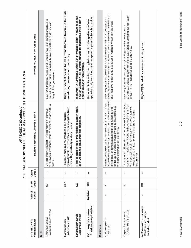
C-2
APP
END
IX C
(Co n
tinue
d)SP
ECIA
LST
ATU
SSP
ECIE
S TH
ATM
AYO
CC
UR
INTH
EPR
OJE
CT
AR
EA
Scie
ntif
ic N
ame
Com
mon
Nam
e
Fede
ral
Stat
us
Stat
e St
atus
CN
PS
List
ing
H
abita
t Des
crip
tion
/ Blo
omin
g Pe
riod
Po
tent
ial t
o O
ccur
in th
e A
ctio
n A
rea
Bird
s
Ath
ene c
unic
ular
ia
Wes
tern
bur
row
ing
owl
-- SC
--
Util
izes
gro
und
squi
rrel
(or o
ther
mam
mal
) bur
row
s w
ithin
ope
n gr
assl
ands
, pra
irie
s, sa
vann
a, o
r agr
icul
tura
l fie
lds.
Low
(B/F
). Po
tent
ial n
estin
g an
d fo
ragi
ng h
abita
t in
annu
al g
rass
land
is
limite
d by
sm
all n
umbe
r of r
oden
t bur
row
s an
d th
e hi
gh d
ensi
ty a
nd
heig
ht o
f the
gra
ss c
over
.
Elan
us le
ucur
us
Whi
te-ta
iled
kite
--
SFP
-- Fo
rage
s in
open
pla
ins,
gra
ssla
nds,
and
pra
irie
s;
typi
cally
nes
ts in
tree
s. O
ften
foun
d al
ong
tree
-line
d ri
ver v
alle
ys w
ith a
djac
ent o
pen
area
s.
Hig
h (B
). Po
tent
ial
nest
ing
habi
tat
pres
ent.
Obs
erve
d fo
ragi
ng i
n th
e st
udy
area
dur
ing
reco
nnai
ssan
ce le
vel s
urve
y.
Lani
us lu
dovi
cian
us
Logg
erhe
ad sh
rike
--
SC
-- N
ests
in d
ense
shru
b or
tree
folia
ge, f
orag
es in
scr
ub,
open
woo
dlan
ds, g
rass
land
s, a
nd cr
opla
nds.
M
oder
ate
(B/F
). Po
tent
ial n
estin
g an
d fo
ragi
ng h
abita
t in
gras
slan
ds a
nd
ripa
rian
veg
etat
ion
is m
oder
atel
y su
itabl
e fo
r log
gerh
ead
shri
ke d
ue to
lim
ited
area
and
frag
men
tatio
n.
Falc
o pe
regr
inus
ana
tum
A
mer
ican
per
egri
ne fa
lcon
D
elis
ted
SFP
--
Mod
erat
e (F
). Po
tent
ial n
estin
g ha
bita
t on
bluf
f alo
ng A
lam
eda
Cre
ek
oppo
site
stu
dy a
rea.
Stu
dy a
rea
may
pro
vide
pot
entia
l for
agin
g ha
bita
t.
Mam
mal
s
Ant
rozo
us p
allid
us
Palli
d ba
t --
SC
-- Pr
efer
s cav
es, c
revi
ces,
hollo
w tr
ees,
or b
uild
ings
in a
reas
ad
jace
nt to
ope
n sp
ace
for f
orag
ing.
Util
izes
cav
es, c
revi
ces
and
min
es fo
r day
roos
ts; a
lso
foun
d in
bui
ldin
gs a
nd
unde
r bar
k. F
orag
es in
ope
n lo
wla
nd a
reas
. Ass
ocia
ted
with
low
er e
leva
tions
in C
alifo
rnia
.
Low
(B/F
). Po
tent
ial b
reed
ing
habi
tat p
rese
nt in
the
ripa
rian
veg
etat
ion
in
the
stud
y ar
ea b
ut p
oten
tial f
or p
rese
nce
is lo
w d
ue to
hab
itat f
ragm
enta
tion
and
inte
nsiv
e hu
man
act
iviti
es a
t Sun
ol Y
ard
and
Wat
er T
empl
e ar
eas.
Cor
ynor
hinu
s tow
nsen
dii
Tow
nsen
d’s b
ig-e
ared
bat
-- SC
--
Thro
ugho
ut C
alifo
rnia
in a
wid
e va
riet
y of
hab
itats
. Mos
t co
mm
on in
mes
ic si
tes.
Roo
sts i
n th
e op
en, h
angi
ng fr
om
wal
ls a
nd c
eilin
gs o
f roc
ky a
reas
with
cav
es o
r tun
nels
. Ro
ostin
g si
tes l
imite
d. E
xtre
mel
y se
nsiti
ve to
hum
an
dist
urba
nce.
Low
(B/F
). R
oost
s in
cav
es, m
ines
, bui
ldin
gs o
r oth
er h
uman
-mad
e st
ruct
ures
. For
ages
in o
pen
low
land
are
as. P
oten
tial b
reed
ing
habi
tat i
s als
o pr
esen
t in
the
ripa
rian
hab
itat i
n th
e st
udy
area
.
Neo
tom
a fu
scip
es a
nnec
tens
Sa
n Fr
anci
sco
dusk
y-fo
oted
woo
drat
-- SC
--
H
igh
(B/F
). W
oodr
at n
ests
obs
erve
d in
stu
dy a
rea.

C-3
APP
END
IX C
(Co n
tinue
d)SP
ECIA
LST
ATU
SSP
ECIE
S TH
ATM
AYO
CC
UR
INTH
EPR
OJE
CT
AR
EA
Scie
ntif
ic N
ame
Com
mon
Nam
e
Fede
ral
Stat
us
Stat
e St
atus
CN
PS
List
ing
H
abita
t Des
crip
tion
/ Blo
omin
g Pe
riod
Po
tent
ial t
o O
ccur
in th
e A
ctio
n A
rea
Vas
cula
r Pla
nts
Atr
iplex
cord
ulat
a H
eart
scal
e --
-- 1B
.2
Ann
ual h
erb.
Che
nopo
d sc
rub,
mea
dow
s and
see
ps,
valle
y an
d fo
othi
ll gr
assl
and
(san
dy)/s
alin
e or
alk
alin
e.
Apr
il –
Oct
ober
.
Non
e. N
o su
itabl
e al
kalin
e ha
bita
t pre
sent
. Not
obs
erve
d du
ring
Apr
il su
rvey
.
Atr
iplex
dep
ress
a Br
ittle
scal
e --
-- 1B
.2
Ann
ual h
erb.
Che
nopo
d sc
rub,
mea
dow
s and
see
ps,
play
as, v
alle
y an
d fo
othi
ll gr
assl
and,
ver
nal p
ools
, al
kalin
e, c
lay.
Apr
il –
Oct
ober
.
Non
e. N
o su
itabl
e al
kalin
e ha
bita
t pre
sent
. Not
obs
erve
d du
ring
Apr
il su
rvey
.
Atr
iplex
joaq
uini
ana
San
Joaq
uin
spea
rsca
le
-- --
1B.2
A
nnua
l her
b. A
lkal
ine;
che
nopo
d sc
rub,
mea
dow
s and
se
eps,
pla
yas,
val
ley
and
foot
hill
gras
slan
d. A
pril
– O
ctob
er.
Non
e. N
o su
itabl
e al
kalin
e ha
bita
t pre
sent
. Not
obs
erve
d du
ring
Apr
il su
rvey
.
Atr
iplex
min
uscu
le Le
sser
sal
tsca
le
-- --
1B.1
A
nnua
l her
b. C
heno
pod
scru
b, p
laya
s, v
alle
y an
d fo
othi
ll gr
assl
and/
alka
line,
san
dy. M
ay –
Oct
ober
. N
one.
No
suita
ble
alka
line
habi
tat p
rese
nt.
Cam
panu
la ex
igua
C
hapa
rral
har
ebel
l --
-- 1B
.2
Ann
ual h
erb.
Cha
parr
al (r
ocky
, usu
ally
ser
pent
inite
). M
ay –
June
. N
one.
No
suita
ble
habi
tat p
rese
nt. N
o se
rpen
tinite
in p
roje
ct a
rea.
Cen
trom
adia
par
ryi s
sp.
cong
doni
i C
ongd
on’s
tarp
lant
-- --
1B.2
A
nnua
l her
b. A
lkal
ine
valle
y an
d fo
othi
ll gr
assl
and.
M
ay –
Oct
ober
(Nov
embe
r).
Non
e. N
o su
itabl
e al
kalin
e ha
bita
t pre
sent
.
Chl
orop
yron
pal
mat
um
Palm
ate-
brac
ted
bird
’s-b
eak
FE
SE
1B.1
A
nnua
l her
b. C
oast
al sa
lt m
arsh
es a
nd s
wam
ps. J
une
– O
ctob
er.
Non
e. N
o su
itabl
e ha
bita
t pre
sent
(no
coas
tal s
alt).
Cla
rkia
conc
inna
ssp.
aut
omix
a Sa
nta
Cla
ra re
d ri
bbon
s --
-- 4.
3 A
nnua
l her
b. C
hapa
rral
and
cis
mon
tane
woo
dlan
d.
(Apr
il) M
ay –
June
(Jul
y).
Non
e. N
o su
itabl
e ha
bita
t pre
sent
. Not
obs
erve
d du
ring
Apr
il su
rvey
.
Heli
anth
ella
cast
anea
D
iabl
o he
liant
hella
--
-- 1B
.2
Pere
nnia
l her
b. B
road
leav
ed u
plan
d fo
rest
, cha
parr
al,
cism
onta
ne w
oodl
and,
coa
stal
scru
b, ri
paria
n w
oodl
and,
val
ley
and
foot
hill
gras
slan
d. M
arch
– Ju
ne.
Non
e. M
argi
nally
sui
tabl
e ha
bita
t pre
sent
. Not
obs
erve
d du
ring
app
ropr
iate
ly
timed
(Apr
il) fi
eld
surv
eys.
Nav
arre
tia p
rost
rata
Pr
ostr
ate
vern
al p
ool
nava
rret
ia
-- --
1B.1
A
nnua
l her
b. C
oast
al s
crub
, mea
dow
s an
ds s
eeps
, va
lley
and
foot
hill
gras
slan
d (a
lkal
ine)
, ver
nal
pool
s/m
esic
. Apr
il –
July
.
Non
e. N
o su
itabl
e ha
bita
t pre
sent
. Not
obs
erve
d du
ring
Apr
il su
rvey
Pole
mon
ium
carn
eum
O
rego
n po
lem
oniu
m
-- --
2.2
Pere
nnia
l her
b. C
oast
al p
rairi
e an
d sc
rub,
low
er m
onta
ne
coni
fero
us fo
rest
. Apr
il –
Sept
embe
r. N
one.
No
suita
ble
habi
tat p
rese
nt. N
ot o
bser
ved
duri
ng A
pril
surv
ey.
Plag
iobo
thry
s gla
ber
Hai
rles
s pop
corn
-flow
er
-- --
1A
Ann
ual h
erb.
Mea
dow
s an
d se
eps (
alka
line)
, mar
shes
an
d sw
amps
(coa
stal
salt)
. Mar
ch –
May
. N
one.
No
suita
ble
habi
tat p
rese
nt. N
ot o
bser
ved
duri
ng A
pril
surv
ey.

C-4
APP
END
IX C
(Con
tinue
d)SP
ECIA
LST
ATU
SSP
ECIE
S TH
ATM
AYO
CC
UR
INTH
EPR
OJE
CT
AR
EA
Scie
ntif
ic N
ame
Com
mon
Nam
e
Fede
ral
Stat
us
Stat
e St
atus
CN
PS
List
ing
H
abita
t Des
crip
tion
/ Blo
omin
g Pe
riod
Po
tent
ial t
o O
ccur
in th
e A
ctio
n A
rea
Vas
cula
r Pla
nts
(con
t.)
Stre
ptan
thus
alb
idus
ssp.
pe
ram
oenu
s M
ost b
eaut
iful j
ewel
-flow
er
-- --
1B.2
A
nnua
l her
b. C
hapa
rral
, cis
mon
tane
woo
dlan
d, v
alle
y an
d fo
othi
ll gr
assl
and.
(Mar
ch) A
pril
– Se
ptem
ber
(Oct
ober
).
Non
e. N
o su
itabl
e ha
bita
t pre
sent
. Not
obs
erve
d du
ring
Apr
il su
rvey
.
Stuc
keni
a fil
iform
is Sl
ende
r-le
aved
pon
dwee
d --
-- 2.
2 Pe
renn
ial r
hizo
mat
ous a
quat
ic h
erb.
Mar
shes
and
swam
ps
(ass
orte
d sh
allo
w fr
eshw
ater
). M
ay –
July
. N
one.
No
suita
ble
habi
tat p
rese
nt.
Trifo
lium
hyd
roph
ilum
Sa
line
clov
er
-- --
1B.2
A
nnua
l her
b. M
arsh
es a
nd sw
amps
, val
ley
and
foot
hill
gras
slan
d (m
esic
, alk
alin
e), v
erna
l poo
ls. A
pril
– Ju
ne.
Non
e. N
o su
itabl
e ha
bita
t pre
sent
. Not
obs
erve
d A
pril
surv
ey.
Trop
idoc
arpu
m ca
ppar
ideu
m
Cap
er-fr
uite
d tr
opid
ocar
pum
-- --
1B.1
A
nnua
l her
b. V
alle
y an
d fo
othi
ll gr
assl
and
on a
lkal
ine
hills
. Mar
ch –
Apr
il.
Non
e. N
o su
itabl
e ha
bita
t pre
sent
. Not
obs
erve
d du
ring
Apr
il su
rvey
.
NO
TES:
Po
tent
ial f
or O
ccur
renc
e:
Low
= N
ot li
kely
to o
ccur
bec
ause
hab
itat s
uita
bilit
y is
low
and
exi
stin
g ba
rrie
rs li
mit
acce
ss
Mod
erat
e =
Hab
itat p
rese
nt b
ut li
mite
d by
qua
lity
and
dist
ance
from
kno
wn
occu
rren
ces
Hig
h =
Hab
itat p
rese
nt a
nd k
now
n oc
curr
ence
s pr
esen
t in
the
stud
y ar
ea o
r nea
rby
Sp
ecie
s th
at h
ave
med
ium
or h
igh
pote
ntia
l to
be im
pact
ed b
y th
e pr
opos
ed p
roje
ct a
re s
how
n in
bol
dfac
e ty
pe.
ST
ATU
S C
OD
ES:
Fe
dera
l: FE
=
Lis
ted
as “
enda
nger
ed”
unde
r the
fede
ral E
ndan
gere
d Sp
ecie
s A
ct
FT
= L
iste
d as
“th
reat
ened
” un
der t
he fe
dera
l End
ange
red
Spec
ies
Act
FS
C
= N
OA
A F
ishe
ries
des
igna
ted
“spe
cies
of c
once
rn”
FPD
=
Pro
pose
d de
liste
d FD
=
Del
iste
d
Stat
e:
SE
= L
iste
d as
“en
dang
ered
” un
der t
he C
alifo
rnia
End
ange
red
Spec
ies
Act
ST
=
Lis
ted
as “
thre
aten
ed”
unde
r the
Cal
iforn
ia E
ndan
gere
d Sp
ecie
s A
ct
SC
= C
alifo
rnia
Dep
artm
ent o
f Fis
h an
d W
ildlif
e de
sign
ated
“sp
ecie
s of
spe
cial
con
cern
” SF
P =
Cal
iforn
ia D
epar
tmen
t of F
ish
and
Wild
life
desi
gnat
ed “
fully
pro
tect
ed”
SOU
RCE:
USF
WS
(201
4), C
DFG
(201
4), C
NPS
(201
4).
CN
PS:
List
1B
= P
lant
s ra
re, t
hrea
tene
d, o
r end
ange
red
in C
alifo
rnia
and
els
ewhe
re
List
2
= P
lant
s ra
re, t
hrea
tene
d, o
r end
ange
red
in C
alifo
rnia
, but
mor
e co
mm
on e
lsew
here
Li
st 3
=
Pla
nts
abou
t whi
ch w
e ne
ed m
ore
info
rmat
ion-
-a re
view
list
Li
st 4
=
Pl
ants
of l
imite
d di
stri
butio
n--a
wat
ch li
st
Type
of W
ildl
ife
Uti
liza
tion
: (B
) = B
reed
ing
(D) =
Dis
pers
al
(A) =
Aes
tivat
ion
(F) =
For
agin
g
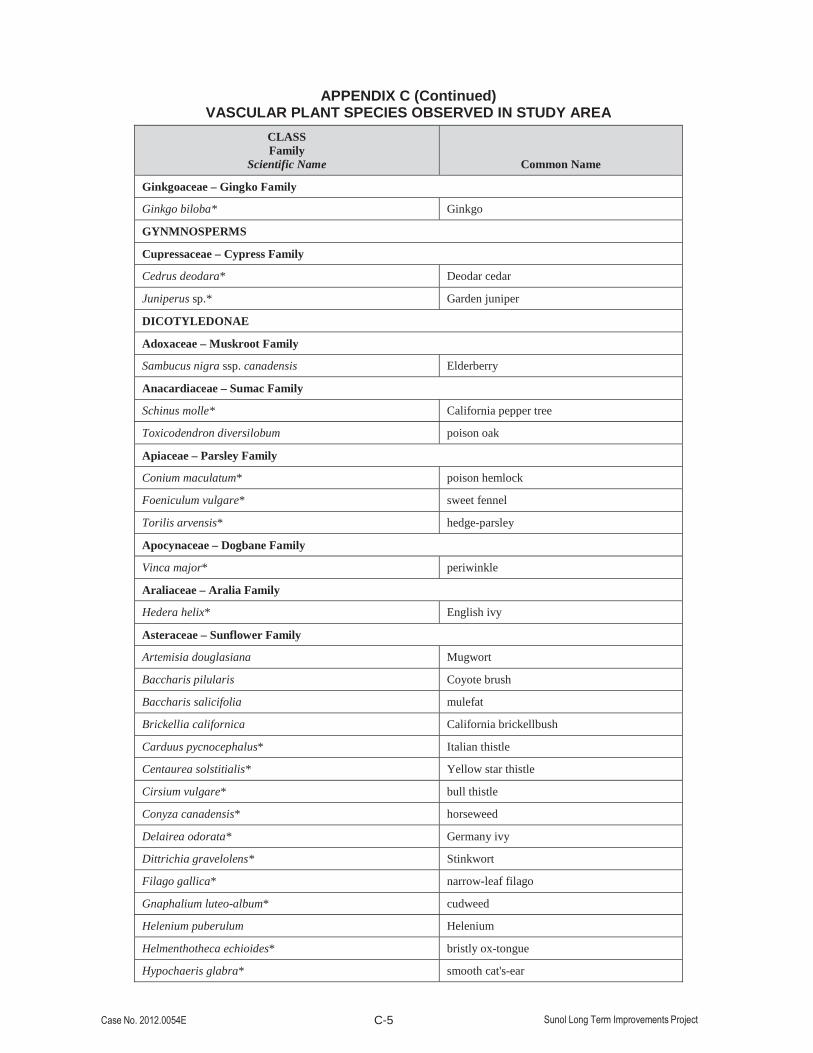
C-5
APPENDIX C (Continued)
VASCULAR PLANT SPECIES OBSERVED IN STUDY AREACLASSFamily
Scientific Name Common Name
Ginkgoaceae – Gingko Family
Ginkgo biloba* Ginkgo
GYNMNOSPERMS
Cupressaceae – Cypress Family
Cedrus deodara* Deodar cedar
Juniperus sp.* Garden juniper
DICOTYLEDONAE
Adoxaceae – Muskroot Family
Sambucus nigra ssp. canadensis Elderberry
Anacardiaceae – Sumac Family
Schinus molle* California pepper tree
Toxicodendron diversilobum poison oak
Apiaceae – Parsley Family
Conium maculatum* poison hemlock
Foeniculum vulgare* sweet fennel
Torilis arvensis* hedge-parsley
Apocynaceae – Dogbane Family
Vinca major* periwinkle
Araliaceae – Aralia Family
Hedera helix* English ivy
Asteraceae – Sunflower Family
Artemisia douglasiana Mugwort
Baccharis pilularis Coyote brush
Baccharis salicifolia mulefat
Brickellia californica California brickellbush
Carduus pycnocephalus* Italian thistle
Centaurea solstitialis* Yellow star thistle
Cirsium vulgare* bull thistle
Conyza canadensis* horseweed
Delairea odorata* Germany ivy
Dittrichia gravelolens* Stinkwort
Filago gallica* narrow-leaf filago
Gnaphalium luteo-album* cudweed
Helenium puberulum Helenium
Helmenthotheca echioides* bristly ox-tongue
Hypochaeris glabra* smooth cat's-ear

C-6
APPENDIX C (Continued)
VASCULAR PLANT SPECIES OBSERVED IN STUDY AREACLASSFamily
Scientific Name Common Name
Hypochaeris radicata* rough cat's-ear
Lactuca serriola* prickly lettuce
Matricaria discoidea* Pineapple weed
Psilocarphus brevissimus Wooly marbles
Senecio vulgaris* Common groundsel
Sonchus asper* prickly sow-thistle
Sonchus oleraceus* common sow-thistle
Taraxacum officinale* common dandelion
Tragopogon porrifolius* salsify
Xanthium strumarium* cocklebur
Betulaceae – Birch Family
Betula sp.* Birch
Bignoniaceae – Trumpet Vine Family
Caltalpa bignonioides* Caltalpa
Brassicaceae – Mustard Family
Brassica nigra* black mustard
Brassica rapa* Field mustard
Cardamine oligosperma* bitter cress
Hirschfeldia incana* hoary mustard
Lepidium nitidum Shining pepperweed
Raphanus sativus* wild radish
Caprifoliaceae – Honeysuckle Family
Lonicera hispidula var. vacillans California honeysuckle
Symphoricarpos albus var. laevigatus snowberry
Caryophyllaceae – Pink Family
Cerastium glomeratum* mouse-ear chickweed
Spergula arvensis ssp. arvensis* Stickwort, starwort
Stellaria media* common chickweed
Spergularia rubra* Sand-spurrye
Crassulaceae – Stonecrop Family
Crassula connata Sand pygmyweed
Fabaceae – Pea Family
Cercis occidentalis Redbud
Lotus corniculatus* bird’s-foot trefoil
Lotus purshianus var. purshianus Spanish clover
Lupinus bicolor bicolor lupine

C-7
APPENDIX C (Continued)
VASCULAR PLANT SPECIES OBSERVED IN STUDY AREACLASSFamily
Scientific Name Common Name
Lupinus nanus sky lupine
Medicago polymorpha* bur-clover
Melilotus officinalis* Yellow sweet clover
Trifolium hirtum* rose clover
Trifolium subterraneum* subterranean clover
Vicia americana American vetch
Vicia sativa ssp. nigra* common vetch
Vicia sativa ssp. sativa* common vetch
Vicia villosa ssp. villosa* hairy vetch
Convolvulaceae – Morning-Glory Family
Convolvulus arvensis* field bindweed
Cucurbitaceae – Gourd Family
Marah fabaceus California man-root
Fagaceae – Oak Family
Quercus lobata Valley oak
Quercus agrifolia coast live oak
Geraniaceae – Geranium Family
Erodium botrys* long-beaked storkbill
Erodium cicutarium* Red-stemmed filaree
Geranium dissectum* cranesbill
Geranium molle* dovesfoot geranium
Geranium purpureum* little robin
Hypericaceae – St. John’s Wort Family
Hypericum perforatum ssp. perforatum* Klamath weed
Juglandaceae - Walnut Family
Juglans californica var. hindsii California black walnut
Lamiaceae – Mint Family
Marrubium vulgare* horehound
Mentha pulegium* penneyroyal
Rosmarinus officinalis* rosemary
Lauraceae – Laurel Family
Umbellularia californica California bay laurel
Lythraceae – Loosestrife Family
Lythrum hyssopifolium* loosestrife
Malvaceae – Mallow Family
Malva nicaeensis* bull mallow

C-8
APPENDIX C (Continued)
VASCULAR PLANT SPECIES OBSERVED IN STUDY AREACLASSFamily
Scientific Name Common Name
Malva parviflora* cheeseweed
Montiaceae – Miner’s Lettuce Family
Calandrinia ciliata Red maids
Claytonia perfoliata Miner’s lettuce
Myrsinaceae – Myrsine Family
Anagallis arvensis* Scarlet pimpernel
Myrtaceae – Myrtle Family
Eucalyptus globulus* blue gum
Onagraceae – Evening Primrose Family
Epilobium brachycarpum fireweed
Orobanchaceae – Broomrape Family
Castilleja attenuata Narrow-leafed owl’s-clover
Castilleja lineariloba Pale owl’s-clover
Oxalidaceae – Oxalis Family
Oxalis micrantha* Dwarf wood sorrel
Oxalis pes-caprae* Bermuda buttercup
Papaveraceae – Poppy Family
Eschscholzia californica California poppy
Fumaria capriolata* Fine-leaved fumitory
Plantaginaceae – Plantain Family
Veronica persica* Persian speedwell
Plantago lanceolata * English plantain
Platanaceae – Plane Tree Family
Platanus racemosa Sycamore
Polygonaceae – Buckwheat Family
Polygonum arenastrum* common knotweed
Polygonum aviculare* knotweed
Rumex acetosella* sheep sorrel
Rumex crispus* curly dock
Rumex salicifolius dock
Primulaceae – Primrose Family
Anagallis arvensis* scarlet pimpernel
Ranunculaceae – Buttercup Family
Ranunculus californicus California buttercup
Rhamnaceae – Buckthorn Family
Rhamnus californica ssp. californica California coffeeberry

C-9
APPENDIX C (Continued)
VASCULAR PLANT SPECIES OBSERVED IN STUDY AREACLASSFamily
Scientific Name Common Name
Rosaceae – Rose Family
Acaena novae-zelandiae* Biddy-biddy
Rosa californica California rose
Rubus discolor* Himalayan blackberry
Rubus ursinus California blackberry
Rubiaceae – Madder Family
Galium aparine* bedstraw
Salicaceae – Willow Family
Salix exigua Sandbar willow
Salix lasiolepis arroyo willow
Sapindaceae – Soapberry Family
Aesculus californica Buckeye
Scrophulariaceae – Figwort Family
Scrophularia californica California bee plant
Verbascum thapsus* mullein
MONOCOTYLEDONAE
Araceae – Arum Family
Zantedeschia aethiopica* Calla lily
Cyperaceae – Sedge Family
Cyperus eragrostis Umbrella sedge
Iridaceae – Iris Family
Iris sp.* Garden iris
Sisyrinchium bellum California blue-eyed grass
Juncaceae – Rush Family
Juncus bufonius var. bufonius toad rush
Liliaceae – Lily Family
Asparagus sp.* asparagus
Poaceae – Grass Family
Aira caryophyllea* silver European hairgrass
Avena barbata* slender wild oat
Avena fatua* wild oat
Briza maxima* big quaking grass
Briza minor* little quaking grass
Bromus carinatus var. carinatus California brome
Bromus diandrus* ripgut brome
Bromus sp.* brome
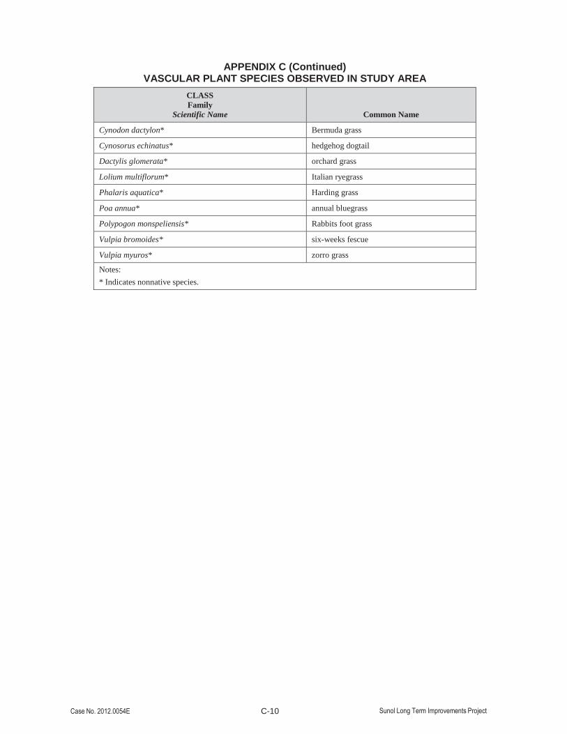
C-10
APPENDIX C (Continued)
VASCULAR PLANT SPECIES OBSERVED IN STUDY AREACLASSFamily
Scientific Name Common Name
Cynodon dactylon* Bermuda grass
Cynosorus echinatus* hedgehog dogtail
Dactylis glomerata* orchard grass
Lolium multiflorum* Italian ryegrass
Phalaris aquatica* Harding grass
Poa annua* annual bluegrass
Polypogon monspeliensis* Rabbits foot grass
Vulpia bromoides* six-weeks fescue
Vulpia myuros* zorro grass
Notes:* Indicates nonnative species.