preliminary conceptual model of the paipa geotermal ... world geothermal congress 2010 bali,...
TRANSCRIPT

Proceedings World Geothermal Congress 2010 Bali, Indonesia, 25-29 April 2010
1
Preliminary Conceptual Model of the Paipa Geothermal System, Colombia
Claudia Alfaro, Francisco Velandia, Hector Cepeda and Natalia Pardo
Ingeominas. Dg. 53 No. 34-53. Bogotá, D. C., Colombia
[email protected], [email protected], [email protected]
Keywords: Paipa geothermal system, Geothermics Colombia, geothermal exploration.
ABSTRACT
Based on the integration of surface studies a geothermal system located in a small caldera shaped by the Paipa volcano after its first eruptive epoch, is proposed. The characteristics of this system include a magmatic heat source with age around 2.5 – 2.1 million years, a deep fractured reservoir, surrounding the extensional basement falls (Paipa-Iza, Cerro Plateado), which additionally are assumed as the possible conduits for the ascent of magma. Although the hydrothermal alteration shows evidence of high temperature fluids (320°C), the current reservoir temperature is unknown as the fluids suffer a “masking” effect by the contribution of highly mineralized surface water and an organic source which affect the geochemical indicators. That is, the chemistry and isotopic composition of the discharged fluids in hot springs are not representative of the reservoir fluids. Secondary reservoirs hosted in the strata of high primary permeability from the sedimentary sequence are proposed. Their lateral extension would allow the geothermal water to flow towards the discharge zone, located northward from the volcanic caldera, which is structurally controlled by crossing fault zones and extensional zones related to the transverse blocks rotation.
1. INTRODUCTION
The geothermal area of Paipa is located in the axial part of the eastern branch of the Colombian Andean Cordillera, south Paipa locality, in Boyacá District (Fig. 1). The hot springs of this area are widely known due to their utilization at many pools of spas and hotels. In 1829 Boussingault (in Boussingault & Roulin, 1824) described these hot springs as unique because of their very high salt contents. Navia & Barriga (1929) described the geology of the area, where they inferred saline banks. They registered the physicochemical analysis of hot spring waters and concluded that the saline banks affect the springs composition.
In 1982, the Latin American Energy Organization (OLADE) published the geothermal reconnaissance studies of the Colombian republic, where based mainly on geological criteria, as the existence of the volcano, its age measured in 2.5 ma, ring shaped pyroclastic deposits and surface hydrothermal alteration, the Paipa geothermal system was classified as medium-high priority area for geothermal exploration. In 1983, the Japan Consulting Institute carried out a visit to the area to determine the possibilities for the installation of a power plant. Based on the reconnaissance study and the field observations, they concluded that although it is possible to find a promising geothermal reservoir for exploitation, advanced stages of exploration should be carried out first.
Paipa
SouthAmerica
Colombia
Paipa
SouthAmerica
Colombia
Figure 1: Location of the Paipa Geothermal Area. The area is located in the axial part of the eastern brand of the Colombian Andean Cordillera, south Paipa locality.
Ferreira & Hernández (1988) postulated from a geological and geochemical study, a geothermal system with the following features: a magmatic intrusion as heat source within the sedimentary sequence, a primary permeability reservoir in sandstones of a sedimentary formation (Une), shallower reservoirs of secondary permeability in fractured rocks, a seal layer made of clay (Churuvita Group), a recharged zone of primary permeability, in the formation which acts a reservoir which comes out to the surface only a few kilometers from the geothermal area and, a discharge zone fed by deep fluids coming out through deep normal NE-WS faults and, a reservoir temperature higher that 200°C estimated from aqueous alkaline geothermometers.
Alfaro et al.
2
Bertrami et al., 1992, based on the chemical and isotopical composition of aqueous and gas phase of hot springs postulated in Paipa, a high temperature geothermal system.
Between 2002 and 2005, INGEOMINAS carried out several studies in the geothermal area of Paipa, orientated to improve the understanding of this geothermal system. A summary of the geological mapping in scale 1:25.000 (Velandia, 2003), the volcanic products mapping (Cepeda & Pardo, 2004) and the geochemistry and isotopy of the hot springs’ aqueous phase (Alfaro, 2002a; Alfaro, 2002b), was presented in the Colombian country update of the previous World Geothermal Congress (Alfaro et al., 2005).
Additional studies, as electromagnetic survey (Vasquez, 2002), radon survey (Alfaro & Espinosa, 2004), geochemistry and isotopy of gases (Alfaro, 2005a) and, a preliminary hydrothermal alteration characterization (Alfaro, 2005), were accomplished by INGEOMINAS. The objective of this work is to contribute to the knowledge of the Paipa geothermal system, by the integration of the studies in a preliminary conceptual model. As this model is based basically in surface studies, complementary geophysical studies (gravimetry, magnetometry and deeper geoelectrical surveys) are being realized, at the present time, to validate the preliminary model. This work was presented in the frame of the X Colombian Geological Congress, in 2005.
2. METHODOLOGY
This work was developed by following the geothermal exploration methodology, particularly the one proposed by OLADE & BID (1993). The conceptual model presented is an interpretation of the results obtained by the application of different tools, to describe some aspects of the constituents of the geothermal system.
3. RESULTS
3.1 Geology
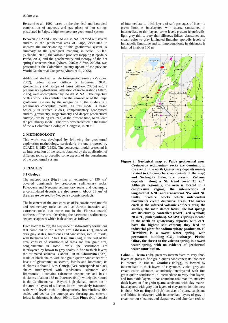
The mapped area (Fig.2) has an extension of 130 km2 covered dominantly by cretaceous sedimentary rocks. Paleogene and Neogene sedimentary rocks and quaternary unconsolidated deposits are also present. About 31 km2 of the area are covered by Neogene volcanic products.
The basement of the area consists of Paleozoic methamorfic and sedimentary rocks as well as Jurasic intrusive and extrusive rocks that come out in the Floresta massif, northeast of the area. Overlying the basement a sedimentary sequence appears which is described as follows:
From bottom to top, the sequence of sedimentary formations that come out to the surface are: Tibasosa (Kt), made of dark gray shales, limestones and sandstones, rich in fossils, with thickness of 132 to 150 m. Une (Ku), at the east of the area, consists of sandstones of gross and fine grain size, conglomeratic in some levels; the sandstones are interlayered by brown to gray shales in fine to thick layers; the estimated sickness is about 510 m. Churuvita (Kch), made of black shales with fine grain quartz sandstones with levels of glauconite, muscovite, fossils and limestone; its thickness is about 215 m. Conejo (Kc), corresponds to black shales interlayered with sandstones, siltstones and limestones; it contains calcareous concretions and has a thickness of about 165 m. Plaeners (Kpl), widely distributed in the Cundinamarca – Boyacá high plateau, comes out in the area in layers of siliceous lidites intensively fractured., with with levels rich in phosphorites, foraminifera, fish scales and debris; the outcrops are shearing and chevron folds; its thickness is about 100 m. Los Pinos (Klp) consist
of intermediate to thick layers of soft packages of black to green limolites interlayered with quartz sandstones in intermediate to thin layers; some levels present ichnofossils, light gray thin to very thin siliceous lidites, claystones and cream color to gray laminated limonite, sporadic levels of lumaquelic limestone and salt impregnations; its thickness is inferred in about 100 m.
Figure 2: Geological map of Paipa geothermal area. Cretaceous sedimentary rocks are dominant in the area. In the north Quaternary deposits mainly related to Chicamocha river (outsite of the map) and Sochagota Lake, are present. Volcanic deposits along a NE trend cover 31 km2. Although regionally, the area is located in a compressive regime, the intersections of longitudinal NNE and transversal NW and NE faults, produce blocks which independent movements create distensive areas. The larger circle is the inferred volcanic edifice’s area; the smaller, the main domes focus. The hot springs are structurally controlled (>50°C, red symbols; 20-40°C, pink symbols). SALPA’s springs located to the north on Quaternary deposits, with 21°C have the highest salt content; they feed an industrial plant for sodium sulfate production. El Hervidero is a sweet water spring, with permanent bubbling CO2 discharge. Piscina Olitas, the closest to the volcano spring, is a sweet water spring, with no evidence of geothermal water contribution.
Labor – Tierna (Klt), presents intermediate to very thick layers of gross to fine grain quarts sandstones; its thickness is inferred in 100 m. Guaduas (KPgg), is formed by intermediate to thick layers of claystones, violet, gray and cream color siltstones, abundantly interlayered with fine grain quartz sandstones in intermediate to very thin layers, and iron oxide layers; it has abundant coal mantles, massive thick layers of fine grain quartz sandstone with clay matrix, interlayared with gray thin layers of claystones; its thickness is about 500 m. Bogotá (Pgb) consists of quartz sandstone and lithics, interlayered with intermediate layers of gray to cream colour siltstones and claystones, and abundant reddish

Alfaro et al.
3
oxides; its thickness is unknown in the area. Tilatá (NgQt) is a widely distributed unit from the Bogotá savanna along the Cundinamarca – Boyacá high plateau to Duitama, located to the north-east of Paipa; it is made of sandy levels in intermediate to thick layers, interlayered with siltstones and varicoloured claystones; the sandstones are quartzous with fine to gross grain; levels of iron oxides and lignite layers are present; its thickness is estimated in 150 m. The Quaternary depostists, found in the valley of Chicamocha river, Sochagota Lake and El Salitre river, south of Paipa, consists of sand, silt, clay and conglomerates from the alluvial, lacustrine and fluvio-lacustrine activity.
The regional tectonic frame indicate structures that can be interpreted as the reactivation of ancient structures and the appearance of new faults under the compressive regime of the Andes orogeny, that in the area show features of a transpressive tectonics. Longitudinal to the Cordillera (NNE) and transversal (NW and NE) faults occur (Fig. 2), which form blocks that can move independently under the transprevise tectonic regime, including rotation.
Two structural styles are found in the area; thick and thin skin; the thick skin faults affect the basement and the thin skin, which are thrust faults cut only the sedimentary rocks of the cover. In the longitudinal faults (NNE), the thick skinned style would be related to the reverse Lanceros Fault, with an opposite dipping respect to the Soapaga Fault (longitudinal fault located to the east of the area, not in the map), between which a block would be expelled in the shape of "pop-up". The thin skinned style is associated to the El Bizcocho and El Batan thrust faults, where the last one represents the front or more distal fault of the overlapped fan that is verging to the SE from the Boyaca Fault, with detachment along the Plaeners Formation bottom.
The transversal NW structures are observed especially to the South of the area. The Cerro Plateado Fault is observed as a shear zone in the hill, it consists of the Une Formation sandstones and with a trace along the Honda Grande creek valley to the NW that separates the volcanic bodies that usually have been known as Olitas on the south and Pan de Azucar to the north. The Paipa - Iza Fault crosses the hill called Alto de los Volcanes, where the Olitas volcanic deposit is located; regionally its trace continues to the SE up to another volcanic body and geothermal system known as Iza. These two faults are interpreted as basement structures related to a previous extensional tectonic phase, which was reactivated during Andean uplift, preserving the character of open breaks that facilitate the hydrothermal fluid to flow; they are also assumed as very deep faults which would allow the magma ascent and the volcanism in the area.
The transversal NE faults affect the sedimentary sequence producing right lateral displacements as it is observed in some microtectonic data. El Hornito and Canocas faults intercept the longitudinal structures and are interpreted as tear structures associated to thrusting. Also, these structures are considered as the most recent result of faulting in the area. The Santa Rita Fault is interpreted as a lateral ramp of El Batan thrust fault.
3.2 Paipa Volcano
Paipa volcano is located about 7 km south of Paipa locality; it has an active hydrothermal system as inferred from the surface manifestations and an inactive volcano-magmatic system. It is an explosive volcano with ryolitic and traquitic composition of alkaline and calcoalkaline affinity, rich in K (the SiO2 rock contents ranges between 68 and 72% and the alkaline elements, between 7 and 10%). Its edifice is eroded
and today, its highest height is 2871 m.a.s.l. The volcanic products cover 31 km2 following a NE trend which length is about 11 km and width of 6 km (Fig. 2). The eruptive history consists of two eruptive epochs: the first one uplifted the volcanic edifice and ended with its collapse and the formation of a 3 km diameter caldera with a depression of about 400 m. The second epoch, interpreted as a resurgence of activity inside the caldera, was characterized by the formation and collapse of intracalderic domes. The age (K/Ar and Ar/Ar) of the domes rocks which appearance corresponds to the first eruptive period of the second epoch was calculated in 2.5 to 2.1 m.a.
The evidence of the caldera formation are: (1) the volcanic area is morphologically divided in two sectors: the NE called El Guarruz and the SW called Olitas. The border is a depression shaped by the valley of two creeks (Honda Grande y El Palacio), that is abruptly interrupted by the volcanic pile. The depression shows a level difference of 200 m towards NE and 321 m with the summit of the Alto de Los Volcanes; it was built on ignimbrites of the firs eruptive epoch by erosive processes, by vertical movements caused by faulting or by the volcanic edifice collapse. (2) The volcanic products of the second eruptive epoch are confined and did not overcome the Honda Grande’s creek depression. (3) There is an small dome in the Honda Grande creek basin which indicate the existence of a weakness zone through which the magma rise was possible; it can happen easily if a calderic border is connected to the magmatic chamber. (4) The volcanic focus of the second eruptive epoch (domes) are closely related to the Paipa – Iza fault, which suggest that the fault connects the surface with the magmatic chamber promoting the magma rise from depth and the calderic collapse. (5) The volcanic products of the second eruptive epoch also found a topographical barrier to the SW beyond the Paipa – Iza fault and (6) the faults that affect the volcanic area shape a close polygon, which corresponds to what is believed is the depression leave by the calderic collapse.
3.3 Hot Springs
The discharge zone of Paipa geothermal system is located between Sochagota Lake (south Paipa locality) in the north and the volcanic domes zone, in the south, apparently aligned in a N-S linear trend (Fig. 2). The springs, structurally controlled by faults intersections, are located in two main sites that from north to south correspond to: ITP-Laceros, in the intersection of El Hornito and El Bizcocho faults, where the highest concentration of springs occur (at least 10) and where Pozo Azul, the most representative of the geothermal system, is located; these springs show abundant gas discharge and a highest temperature of 70°C. La Playa site, located in the intersection of El Batán and Rancho Grande faults, has 3 springs with low gas discharge and the highest temperature of the geothermal area (76°C). Additionally, low temperature springs are found in the sector of SALPA (Salts of Paipa) (21°C), El Hervidero (22°C) and Piscina Olitas (23.2°C). The springs of SALPA, located in the Chicamocha’s river flood zone, exhibit high CO2 discharge and the highest salt content (about 55000 mg/l) dominated by sodium sulfate which is used in a small salt plant, for industrial uses. El Hervidero, is a sweet water spring located along Cerro Plateado normal fault in the limit of the inferred volcanic edifice, is an ebullient spring with permanent CO2 discharge, which does not seem to be related to the geothermal fluid. Finally Piscina Olitas, also a sweet water spring, although is located close to the domes focus; does not show evidence of geothermal fluid contribution. Its SiO2 concentration close to 100 mg/l becomes its particular feature, which could be explain in the interaction between

Alfaro et al.
4
infiltrated water and siliceous rocks, as the rhyolitic and traquitic volcanic rocks, with conductive cooling with no SiO2 loss.
The observed structural control on the springs occurrence, is confirm by the radon survey in soil’s air. This survey did not cover the whole geothermal area and was carried out along perpendicular lines to the alignment trend of the springs. However a good correlation was found in the highest radon anomaly (12000 to 15000 pCi/l) and the intersection of El Hornito and El Bizcocho faults, where the main discharge zone is located (Fig. 3). Other anomally of the same order was measured southwest of La Playa sector, close to the only found steam vent of low temperature (75°C), located in the intensively fracture Plaeners formation, close to the interpcetion of Cerro Plateado and El Batán fault. Lower radon measurements coincide with lower discharge areas.
Figure 3: Radon emmanometry in soil’s air. Th-232 dominates the radon source. The highest radon emmisions are found in the intersection of El Hornito and El Bizcocho faults where the main discharge zone is located (ITP-Lanceros sector).
Based on the chemical and isotopical composition of the aqueous phase, represented by the triangular Na-K-Mg diagram (Fig. 4) and the δ D Vs δ18O diagram (Fig. 5), the hot springs of this geothermal area, receive a contribution of the low temperature and high salinity source which representative surface manifestations correspond to SALPAS’ springs. That contribution affects in a higher proportion, the closest hot springs of ITP-Lanceros than those from La Playa sector. The mixing with the sodium sulfate source produces a “masking” effect on the chemical and isotopical composition which prevents the geochemical tools to be applied. The only aqueous species that seems to be controlled by the geothermal fluid contribution is the fluoride; its highest concentration is found in La Playa (20
mg/l), it get reduced in the ITP-Lanceros springs (14-15 mg/l) and gets down to 6 mg/l in SALPA springs.
The SiO2 concentration, responds to the temperature variation; however the quartz geothermometer does not seem to be adequate as results in temperatures of 110-120 at most. The chalcedony geothermometer indicate deep temperatures between 85 and 95°C. The highest temperature is estimated by an enthalpy - SiO2 model by assuming simple dilution, around 230°C.
Figure 4: Relative Na-K-Mg composition (after Giggenbach, 1988). A mixing line trend relates the low temperature, high salinity springs (apparently along the equilibrium line) with the Paipa geothermal area hot springs.
-11.0 -10.0 -9.0 -8.0 -7.0 -6.018O [o/oo] V-SMOW
-80.0
-75.0
-70.0
-65.0
-60.0
-55.0
-50.0
-45.0
-40.0
-35.0
D [o
/oo)
V-S
MO
W Líne
a m
eteór
ica g
lobal
δ
δ
Y = 7.
04606 *
X + 5.
5662
9
R = 0.99
3
δ2 Η= 8
∗δ18 Ο+1
0
Línea de mezcla
Miembro extremode mezcla
-11.0 -10.0 -9.0 -8.0 -7.0 -6.018O [o/oo] V-SMOW
-80.0
-75.0
-70.0
-65.0
-60.0
-55.0
-50.0
-45.0
-40.0
-35.0
D [o
/oo)
V-S
MO
W Líne
a m
eteór
ica g
lobal
δ
δ
Y = 7.
04606 *
X + 5.
5662
9
R = 0.99
3
δ2 Η= 8
∗δ18 Ο+1
0
Línea de mezcla
Miembro extremode mezcla
Figure 5: Stable isotopes in aqueous phase of hot springs from Paipa geothermal area. An oxygen-18 enrichement that could be related to the intense rock-water interaction at the geothermal reservoir is actually due to the mixing with the low temperature, high salinity source which is also oxygen-18 enriched. The mixing effect with the hot springs is revealed by the linear trend.
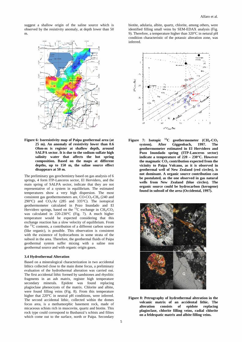
The influence of the salt source is also observed by the resistivity measurements of the electromagnetic survey (Fig. 6). The isoresistivity maps at different depths show the high conductivity source (resistivity values lower than 0.6 Ohm-m), concentrated at SALPA sector. The results of this survey
Alfaro et al.
5
suggest a shallow origin of the saline source which is observed by the resistivity anomaly, at depth lower than 50 m.
Figure 6: Isoresistivity map of Paipa geothermal area (at 25 m). An anomaly of resistivity lower than 0.6 Ohm-m is register at shallow depth, around SALPA sector. It is due to the sodium sulfate high salinity water that affects the hot spring composition. Based on the maps at different depths, up to 150 m, the saline source effect disappears at 50 m.
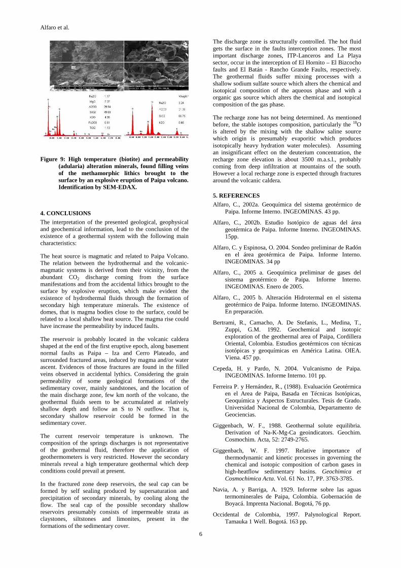
The preliminary gas geochemistry based on gas analysis of 6 springs, 4 form ITP-Lanceros sector, El Hervidero, and the main spring of SALPA sector, indicate that they are not representative of a system in equilibrium. The estimated temperatures show a very high dispersion. The most consistent gas geothermometers are, CO-CO2-CH4 (240 and 290°C) and CO2/Ar (285 and 335°C). The isotopical geothermometer calculated in Pozo Inundado and El Hervidero springs, based on the 13C exchange in CH4/CO2 was calculated in 220-230°C (Fig. 7). A much higher temperature would be expected considering that this exchange reaction has a slow velocity of equilibrium. From the 13C contents, a contribution of a different carbon source (like organic), is possible. This observation is consistent with the existence of hydrocarbons in some strata of the subsoil in the area. Therefore, the geothermal fluids of Paipa geothermal system suffer mixing with a saline non geothermal source and with organic origin gases.
3.4 Hydrothermal Alteration
Based on a mineralogical characterization in two accidental lithics collected close to the main dome focus, a preliminary evaluation of the hydrothermal alteration was carried out. The first accidental lithic formed by sandstones and rhyolitic fragments in an ash matrix, register high temperature secondary minerals. Epidote was found replacing plagioclase phenocrysts of the matrix. Chlorite and albite, were found filling veins (Fig. 8). From this temperature higher that 220°C in neutral pH conditions, were inferred. The second accidental lithic, collected within the domes focus area, is a methamorphic basement rock, made of micaceous schists rich in muscovite, quartz and biotite. This rock type could correspond to Busbanzá’s schists and filites which come out to the surface, north or Paipa. Secondary
biotite, adularia, albite, quartz, chlorite, among others, were identified filling small veins by SEM-EDAX analysis (Fig. 9). Therefore, a temperature higher than 320°C in netural pH condition characteristic of the potassic alteration zone, was inferred.
Figure 7: Isotopic 13C geothermometer (CH4-CO2
system). After Giggenbach, 1997. The geothermometer estimated in El Hervidero and Pozo Inundado spring (ITP-Lanceros sector) indicate a temperature of 220 – 230°C. However the magmatic CO2 contribution expected from the vicinity to Paipa Volcano, as it is observed in geothermal well of New Zealand (red circles), is not dominant. A organic source contribution can be postulated, as the one observed in gas natural wells from New Zealand (blue circles). The organic source could be hydrocarbon (kerogene) found in subsoil of the area (Occidental, 1997).
Figure 8: Petrography of hydrothermal alteration in the volcanic matrix of an accidental lithic. The alteration consists of epidote replacing plagioclase, chlorite filling veins, radial chlorite on a feldespatic matrix and albite filling veins.
Alfaro et al.
6
Figure 9: High temperature (biotite) and permeability (adularia) alteration minerals, found filling veins of the methamorphic lithics brought to the surface by an explosive eruption of Paipa volcano. Identification by SEM-EDAX.
4. CONCLUSIONS
The interpretation of the presented geological, geophysical and geochemical information, lead to the conclusion of the existence of a geothermal system with the following main characteristics:
The heat source is magmatic and related to Paipa Volcano. The relation between the hydrothermal and the volcanic-magmatic systems is derived from their vicinity, from the abundant CO2 discharge coming from the surface manifestations and from the accidental lithics brought to the surface by explosive eruption, which make evident the existence of hydrothermal fluids through the formation of secondary high temperature minerals. The existence of domes, that is magma bodies close to the surface, could be related to a local shallow heat source. The magma rise could have increase the permeability by induced faults.
The reservoir is probably located in the volcanic caldera shaped at the end of the first eruptive epoch, along basement normal faults as Paipa – Iza and Cerro Plateado, and surrounded fractured areas, induced by magma and/or water ascent. Evidences of those fractures are found in the filled veins observed in accidental lythics. Considering the grain permeability of some geological formations of the sedimentary cover, mainly sandstones, and the location of the main discharge zone, few km north of the volcano, the geothermal fluids seem to be accumulated at relatively shallow depth and follow an S to N outflow. That is, secondary shallow reservoir could be formed in the sedimentary cover.
The current reservoir temperature is unknown. The composition of the springs discharges is not representative of the geothermal fluid, therefore the application of geothermometers is very restricted. However the secondary minerals reveal a high temperature geothermal which deep conditions could prevail at present.
In the fractured zone deep reservoirs, the seal cap can be formed by self sealing produced by supersaturation and precipitation of secondary minerals, by cooling along the flow. The seal cap of the possible secondary shallow reservoirs presumably consists of impermeable strata as claystones, siltstones and limonites, present in the formations of the sedimentary cover.
The discharge zone is structurally controlled. The hot fluid gets the surface in the faults interception zones. The most important discharge zones, ITP-Lanceros and La Playa sector, occur in the interception of El Hornito – El Bizcocho faults and El Batán - Rancho Grande Faults, respectively. The geothermal fluids suffer mixing processes with a shallow sodium sulfate source which alters the chemical and isotopical composition of the aqueous phase and with a organic gas source which alters the chemical and isotopical composition of the gas phase.
The recharge zone has not being determined. As mentioned before, the stable isotopes composition, particularly the 18O is altered by the mixing with the shallow saline source which origin is presumably evaporitic which produces isotopically heavy hydration water molecules). Assuming an insignificant effect on the deuterium concentration, the recharge zone elevation is about 3500 m.a.s.l., probably coming from deep infiltration at mountains of the south. However a local recharge zone is expected through fractures around the volcanic caldera.
5. REFERENCES
Alfaro, C., 2002a. Geoquímica del sistema geotérmico de Paipa. Informe Interno. INGEOMINAS. 43 pp.
Alfaro, C., 2002b. Estudio Isotópico de aguas del área geotérmica de Paipa. Informe Interno. INGEOMINAS. 15pp.
Alfaro, C. y Espinosa, O. 2004. Sondeo preliminar de Radón en el área geotérmica de Paipa. Informe Interno. INGEOMINAS. 34 pp
Alfaro, C., 2005 a. Geoquímica preliminar de gases del sistema geotérmico de Paipa. Informe Interno. INGEOMINAS. Enero de 2005.
Alfaro, C., 2005 b. Alteración Hidrotermal en el sistema geotérmico de Paipa. Informe Interno. INGEOMINAS. En preparación.
Bertrami, R., Camacho, A. De Stefanis, L., Medina, T., Zuppi, G.M. 1992. Geochemical and isotopic exploration of the geothermal area of Paipa, Cordillera Oriental, Colombia. Estudios geotérmicos con técnicas isotópicas y geoquímicas en América Latina. OIEA. Viena. 457 pp.
Cepeda, H. y Pardo, N. 2004. Vulcanismo de Paipa. INGEOMINAS. Informe Interno. 101 pp.
Ferreira P. y Hernández, R., (1988). Evaluación Geotérmica en el Area de Paipa, Basada en Técnicas Isotópicas, Geoquímica y Aspectos Estructurales. Tesis de Grado. Universidad Nacional de Colombia, Departamento de Geociencias.
Giggenbach, W. F., 1988. Geothermal solute equilibria. Derivation of Na-K-Mg-Ca geoindicators. Geochim. Cosmochim. Acta, 52: 2749-2765.
Giggenbach, W. F. 1997. Relative importance of thermodynamic and kinetic processes in governing the chemical and isotopic composition of carbon gases in high-heatflow sedimentary basins. Geochimica et Cosmochimica Acta. Vol. 61 No. 17, PP. 3763-3785.
Navia, A. y Barriga, A. 1929. Informe sobre las aguas termominerales de Paipa, Colombia. Gobernación de Boyacá. Imprenta Nacional. Bogotá, 76 pp.
Occidental de Colombia, 1997. Palynological Report. Tamauka 1 Well. Bogotá. 163 pp.

Alfaro et al.
7
OLADE, ICEL, Geotérmica Italiana y CONTECOL. 1982. Estudio de reconocimiento de los recursos geotérmicos de la República de Colombia. Informe final. 455 pp.
OLADE y BID. 1993. Guía para estudios de reconocimiento y prefactibilidad geotérmicos. Quito, Ecuador. Pp150.
Vásquez, L. 2002. Exploración geofísica con el método electromagnético en el municipio de paipa. Informe Interno INGEOMINAS. 16 pp.
Velandia, F. 2003. Cartografía geológica y estructural Sector Sur del Municipio de Paipa. Informe Técnico. INGEOMINAS. 31 pp.