prelimcrv natural area site management plan 03 … · cave river valley natural area site...
TRANSCRIPT

CAVE RIVER VALLEY NATURAL AREA
Site Management Plan
March 18, 2009
Indiana State Parks and Reservoirs 402 W.Washington Room W298 Indianapolis, IN 46204 Spring Mill State Park PO Box 376 Mitchell, IN 47446


TABLE OF CONTENTS Page Introduction..........................................................................................................................1 Purpose Statement................................................................................................................1 Property Description ............................................................................................................1 Natural Area Evaluation and Restoration ............................................................................3 Historic Resource Evaluation and Cultural Resource Management………………………4 Facility Usage and Development .........................................................................................5 Public Access in Conjunction with Habitat Conservation Land Acquisition Grant............7 Security ................................................................................................................................8 Outstanding Leases and Contracts .......................................................................................8 Habitat Management Objectives..........................................................................................8
Hibernacula for the Indiana Bat...............................................................................8 Restoration of Pre- and Early Settlement Conditions ..............................................9
Education ...........................................................................................................................10 Spring Mill State Park Interpretive Services……………………………………..10 Outdoor Activities..................................................................................................11 Research.................................................................................................................11
Media Plan .........................................................................................................................11 Transition Plan ...................................................................................................................12 Benefits ..............................................................................................................................12 APPENDIX I: Cave River Valley Structure Retention and Disposition Plan…………..14 APPENDIX II: Initial Development of Recreational Facilities…………………………15 APPENDIX III: Estimated Costs for Site Development………………………………..16 APPENDIX IV: Estimated Annual Operating Costs........................................................17 APPENDIX V: Estimated Revenue for Property .............................................................18 APPENDIX VI: Map of Proposed Development Areas ...................................................19
1
INTRODUCTION This master plan is intended to serve as a guide for the development of Cave River Valley Natural Area. It will define, in fairly broad strokes, the Division of State Parks and Reservoir’s objectives and sideboards for start up and development of the property to be managed as a satellite of Spring Mill State Park. Long term funding for the property is currently being added to the budget request for Spring Mill State Park beginning with the 2009-2011 biennium. Input from project partners, project supporters and concerned citizens of Indiana will be requested and given full consideration in the implementation of this plan. PURPOSE STATEMENT The primary purpose of this project is to secure a parcel of important karst topography, representative of the Mitchell Plateau physiographic region in Indiana. This section of karst holds particular importance, as the property will protect a hibernaculum and surrounding summer habitat for the federally and state endangered Indiana bat (Myotis sodalis). Upland areas will be managed with limited development, and the goal of approximating pre-settlement conditions across the property. PROPERTY DESCRIPTION The Cave River Valley property consists of about 300 acres located to the north of Campbellsburg, Indiana on Cave River Valley Road. This property is divided into three parcels by county road. The primary (and, by far, the largest) parcel is currently gated and operated with an on-your-honor iron ranger. The primary parcel consists of a valley surrounded by bluffs and ridges. The most noteworthy feature of the property is its caves. Endless Cave, also known as Dry Clifty Cave, has a surveyed length of 6903 feet. The first written description of this cave appeared in 1896 by Dr. W.S. Blachley. A key significance of Endless Cave is its status as a known hibernaculum for the endangered Indiana bat (Myotis sodalis); it was the eighth largest hibernaculum for this species in the state of Indiana in 2007. Of particular relevance for Spring Mill State Park, one section of Endless Cave has been given the name “Hamer’s End.” Hugh Hamer, who played a significant role in the history of Spring Mill Village, is believed to have apprenticed with John Hammersley on the property now known as Cave River Valley. It is not unreasonable to suspect that Hugh, or his brother Thomas, explored Endless Cave during their time on the property. The likelihood that Hugh and or Thomas ventured into area caves is bolstered by the fact that one of Hugh’s sons left his signature inside Hamer Cave at Spring Mill, perhaps making for a case of “like father like son”. Historical signatures have been recorded in the interior of Endless Cave. The text of these historical signatures is not noted in any sources consulted thus far, but there is certainly a possibility that a Hamer signature may be among the text.
2
River Cave, also known as Wet Clifty Cave, is the other large cave in the valley. It stretches for a surveyed length of 3853 feet and features one of the longest straight passages in the world (a single survey shot traveling for over 600 feet). The cave is home to both the state endangered northern blind cavefish and blind crayfish. Features include a small waterfall, chert lenses, and natural bridges, but, overall, there are few speleothems. Water from this cave is the initial source of the stream that runs through the valley. It was along this stream that John Hammersley operated his mill in the 1800s.
“Where the stream came out of the cave they built a stone wall, and placed a large poplar log in the center of it with a flume hewn out of the log almost two feet wide and two feet deep. This emptied the water into a long flume… leading to the top of the twenty-two foot overshot water wheel which they built.”
Evans, Norman C. Hidden Valley Village. Mill Lake Press, 1953. pg 41
Water from River Cave was used not only for grinding cornmeal but also in the making of whiskey and apple cider, and it also supplied power for a rock-wool plant. A cement dam was built across the mouth of the cave around the beginning on the 20th century. Beginning in 1905, John Bronson began offering boat trips into River Cave for 10 cents a person. A boat is generally recognized as a necessity for the exploration of this cave as the water depth inside the entrance is above a person’s head for the first 200 feet of passage. “Bugs” Armstrong, now well known in the area caving community for his work with the Lost River system, used dynamite to open the entrance to Lake Cave in 1958. Located on the edge of an artificial lake in the valley (which is no longer present), Lake Cave is a low, wet crawl all the way through its 656 surveyed feet; standing is possible only in the room at the end of the passageway. Crumbling Crevices refers to a series of small shelters, crevices, and other solution features in the limestone bluffs overlooking the valley. A 300-foot cave was once noted as part of these bluffs, but has not since been documented. Bear Den Shelter is located in a sinkhole between Endless Cave and River Cave; the 37-foot passage has two entrances. Record was made of a petroglyph close by that resembled a bird whose wings had four feathers. There is also reference to a story about the cave that links it to John Hammersley’s brother. Dorsey Cave is, depending on the source materials referenced, between 7,500 and 8,000 feet long. The entrance section is very wet and the cave is prone to flooding. Dorsey Cave may extend off the Cave River Valley property. The next five caves are believed to be a part of the current Cave River Valley property, but there is some uncertainty. They may be located just outside the now-existing property boundaries, although they are listed in literature as being a part of Cave River Valley. Knight Cave, located on a bluff, is 39 feet in length. Cathy Cave, only 15 feet long, has two entrances and is also atop

3
a bluff. Green’s Crawl is a small spring; the interior is 35 feet long. Crystal Spring has 120 feet of passage. Frozen Waterfall Cave has been “discovered” so many times that it is perhaps the most named cave in Indiana. Its other names include Crabapple, Combs, Snake, Flowstone, Formation, and a personal favorite, Dead Sheep. The entrance is a 20-foot deep pit; although ropes are recommended for entry, they are not a necessity as the pit can be free-climbed. This cave contains about 350 feet of passages with significant flowstone formations, a natural bridge, and gorgeous (although heavily vandalized) speleothems. Current facilities all lie in the valley and consist of a log cabin, cinder block building, open-air shelter, pit toilet, small footbridge, several campsites, and several small incidental structures. All facilities are in varying states of disrepair from extended lack of maintenance. A road comes down from the ridge into the valley, traverses the valley alongside the creek bed, and turns back up the ridge to make a loop. The road is in extremely poor condition and is, for practical purposes, impassable except along top of the ridge. NATURAL AREA EVALUATION AND RESTORATION A floral inventory needs to be completed to assess the ecological significance of the property’s plant life. Such an inventory is important to guide the placement of trails and other facilities so that they do not inadvertently destroy significant floral resources or unique communities. The study can also identify the invasive species that are on the property. We are working to get a copy of notes compiled by a firm that appraised timber on the property. This will hopefully provide initial information regarding the forest composition, structure, and overall health. In the cave system, a survey has already been completed of both biota and speleothems. We are currently waiting for a copy of this survey from The Nature Conservancy in order to evaluate additional cave research needs. As the endangered Indiana bat (Myotis sodalis) is already known to use Endless Cave as a hibernaculum, we expect to gate the entrance to this cave and allow access only during the non-hibernation season (currently considered May 1 – August 14). We will request permission from the current landowner to allow IDNR Division of Fish and Wildlife/U.S. Fish and Wildlife Service access prior to purchase by IDNR to observe bat exit patterns from the cave, which may assist in gate design. At River Cave, the extended length of deep water at the entrance will serve as a natural deterrent for the majority of would-be vandals and control overall casual access. Both River Cave and Endless Cave have artificial concrete dams outside their entrances. The dam at Endless Cave appears to have little to no impact on water flow as the top of the dam is virtually level with the bottom of the creek bed just outside the cave entrance. At River Cave, though, the dam does have an impact on water level and, in addition, breaks up the natural look of the entrance much more than at Endless Cave. We propose removing the dam at River Cave to restore natural stream flow. This would be done in stages to allow sediment collected behind the dam to continue on downstream. We also recommend removing the dam at Endless Cave to restore natural entrance conditions. This proposal would be implemented only after determination of the historical significance of the
4
dams and evaluation of the potential environmental impact on biota and speleothems. There is old piping affiliated with the supply of water from River Cave that will also need to be removed. The small, artificial, fishing pond in the valley is in poor condition; it is currently a much more inviting place for mosquitoes than for fish. As this is a manmade structure and would require significant financial resources to restore and return to regular stocking of fish, we believe that the property would be best served by removing this small pond and restoring conditions approximate to pre-settlement. An artificial lake that once existed on the property has been filled with sediment for a number of years, and the lake bottom has been following a natural succession process. In order to promote this natural succession, we recommend removing remnants of the lake’s levee to help return the area to pre-settlement conditions. Limestone glade remnants (noted on the property), in combination with karst resources, may provide support to an anticipated proposal to place a portion of the property into a new state dedicated nature preserve. Further natural resource evaluation may lead to the implementation of additional resource management, including but not limited to: prescribed burns, deer reduction hunts, and chemical treatment of invasive species. Each of these management practices will be evaluated for potential impact to the summer habitat and hibernacula of Indiana bat prior to implementation. All resource management will be carried out with strict adherence to bat management guidelines provided through the USFWS Bloomington field office. HISTORIC RESOURCE EVALUATION AND CULTURAL RESOURCE MANAGEMENT There are several historic features visible throughout the property, and more are guaranteed to surface as a result of survey and research work. An initial survey and mapping project needs to be conducted for the known sites, followed by a review of the historical record to document those sites and identify additional ones. A site history should be compiled that includes a land ownership and usage record. To support the written documentation, an effort will be made to compile a collection of photographs that documents the post-1900 period of the property. Such photographs should be available given the long commercial history of this site. After the park assumes management of the site, area newspapers will be contacted to solicit community assistance in locating old photos and other memorabilia. The majority of the 316 acre Cave River Valley property has been purchased with a federal grant from the United States Fish and Wildlife Service (USFWS). This is the Endangered Species Habitat Conservation Land Acquisition Grant E-6-HL-1. The 6.4 acre campground site is excluded from the federal nexus as it was purchased solely with state funds.
5
Accepting the use of federal aid for the acquisition of this property initiates federal requirements in terms of cultural resource management in perpetuity. Activities conducted on this portion of the property must comply with Section 106 of the National Historic Preservation Act. A Section 106 review is necessary if a project involves disturbing the soil or if the appearance of a building or structure is to be changed in any way. This requires the Indiana State Historic preservation Officer (SHPO) to conduct an analysis for historic buildings, structures, districts, objects and archaeological resources within the area of potential effects. FACILITY DEVELOPMENT Spring Mill State Park will restore, develop, maintain, and promote utilization of this property (See Appendix 1, Appendix 2): Note: a 200-foot non-development zone will be maintained around any sinkhole that may be in an area designated for development. At the entry point to the primary parcel, we will install an automatic gate connected to an iron ranger. Payment of the standard state park daily entrance fee would be made to the iron ranger to gain access to the property. Annual pass holders will record their pass number on a payment envelope for entry. The iron ranger would be in used in lieu of an entrance gate, which would require staffing on a daily basis (as is done at Spring Mill State Park). One example of a working iron ranger system is viewable online at http://www.parks.ca.gov/?page_id=866. Staffing costs for an entrance gate currently run $192 a day for 24-hour coverage. Even if staffing was limited to a single shift, and to the peak season period (late April through October), the total cost for a season would amount to about $14,000. We do not anticipate a level of visitor attendance that would justify such a staffing expense at this time. The iron ranger will also handle walk-in camping registration if it is made available, although the most efficient mechanism will be including such sites on the IDNR Central Reservation System and make camping reservations mandatory for Cave River Valley. This would eliminate the difficulty of scheduling daily trips by park staff to collect camping registrations; instead, a weekly visit to collect entrance fees deposited in the iron ranger would be sufficient. The current roadway enters the primary section of the property and then splits in two directions. Following the road to the left leads you straight down into the valley; this section of roadway is in extremely poor condition and virtually unusable. We will install a gate at the top of the hill to block vehicular access, and then convert this section of road into a hiking path consisting of packed limestone that would also be suitable for usage by park utility vehicles (UTVs), service vehicles and local emergency vehicles. Immediately across from the gate, a small parking area would be developed for use as a picnic area. All hiking paths through the property would have their trailheads located at this location. At the base of the hill, the road parallels the creek and runs through the valley. The road crosses the creek for the first time on a concrete bridge; the creek has undercut the bridge, creating

6
structural problems. Our design for usage of the valley area, detailed below, would eliminate the need for most vehicular access and confine the majority facilities to the near side of the creek, such that a standard vehicular bridge would no longer be necessary. Therefore, we propose removing the current bridge and replacing it with a concrete ford across the creek bed, which would be suitable for crossing by park UTVs (a ford similar to that proposed is currently in use at Cascades Park in Bloomington, Indiana). Alternately, a free-span bridge, wide enough for a park UTV to cross, could be constructed to replace the existing crossing. The road continues down the valley past the bridge before crossing the creek once again and then turning back uphill toward the ridge. There is no bridge present at this second crossing and no compelling reason to maintain a secondary vehicular access road into the valley. The road should be officially abandoned prior to this second creek crossing and maintained as a path for hikers, but wide enough for use by park UTVs. From the second creek crossing and then back up to the top of the ridge, the road should be closed and a path maintained for hikers only. At this time, we do not have a recommendation as to how hikers would access the other side of the creek from this location; construction of a bridge would be expensive due to the width of the creek. During the majority of the year, water levels are such that most hikers can simply walk across (although they would get their feet wet in doing so). The other main section of road travels along the ridgeline and currently connects the two drives down into the valley. This section of roadway is in relatively good shape. We propose that it be upgraded to a two-lane roadway and extended to create a driving loop on top of the ridge. Eight to ten primitive campsites would be developed along this loop, plus two to three group sites (each with approx. 15-20 person occupancy). Total campground occupancy would amount to 120 people, allowing the area to be serviced by a single vault toilet. A standard pit toilet will also be installed in a central location on the loop. We recommend charging standard DNR rates for the campsites. Several campsites that currently exist along the creek through the valley will be closed to minimize human disturbance in this area. This is consistent with recommendations for management of areas surrounding Indiana bat (Myotis sodalis) hibernacula and summer habitat. Providing water for campsites in the valley would also be an issue. There are two “taps” that go with the property, but, due to the slope and rocky conditions, it would be costly to get water into the valley for camper use. An existing outhouse, which appears to overflow into the valley stream, will be removed. In its place, a new composting toilet would be installed in the main section of the valley (in the area between the cinder block building and open-air shelter, facilities that are described below). A composting toilet will eliminate the need for regular waste removal (as regular waste removal would require a higher-grade road into the valley). As mentioned earlier, all hiking trails would have their head at a central location atop the ridge. From this location, a hiking path will follow the current roadway down into and then through the valley, exiting along the roadbed at the other end. Side trails will take hikers to the entrances of both River Cave and Endless Cave. Another trail will start at the same location but then circle the valley from the ridge top. This path would connect both ends of the valley trail.
7
A final trail would also take off from the trailhead but angle back toward the entry to the property. At the county road, it will cross over to the other parcel (a section that is on one’s right side when approaching the primary parcel from Campbellsburg). It will make a small loop through this parcel before returning across the road by the same path. PUBLIC ACCESS AND THE HABITAT CONSERVATION LAND ACQUISITION GRANT The Cave River Valley (CRV) property, Habitat Conservation Land Acquisition Grant E6HL1, provided funding for the purchase in part of this site. The federal nexus on the Cave River Valley grant acquisition area does not extend to the campground at Cave River Valley or the Spring Mill State Park. Neither the main park nor campground was purchased with Department of Interior grant assistance or hunting and fishing license revenue. Operation and maintenance activities for the entire property are completely funded with state dollars. Access to the caves located on property purchased with the Cave River Valley Acquisition grant (E-6-HL-1) will be free. Caves on the property may be closed to the public during certain times, such as Indiana bat hibernation periods. Closure periods will be based on management plans for the recovery of the Indiana bat. The entire property will be subject to the standard state park entrance fee. This means visitors using the area must be legally entitled to enter an Indiana State Park, either with a daily pass or annual entrance permit, when they visit. Visitors can take full advantage of amenities provided for state park visitors, such as parking, hiking trails, or comfort areas during or after their visit to Cave River Valley. No additional fees will be charged for access to the caves. Park entrance fees do not result in grant related program income. Camping, which will not occur on grant related property, will be priced and managed as any other State Parks and Reservoirs (SPR) campground will be managed. SPR may offer guide service for some of the free caves on the property, both main park and or Cave River Valley. SPR may choose charge a fee for guide service, but not for entrance to the Cave River Valley Caves. The guide service does not result in grant related program income as long as entrance to the caves is free and the guide service is optional. SPR plans for facilities, such as an “iron ranger” to allow persons to purchase an entrance permit at this remote property to eliminate the need to drive to the main park office or provide a staffed entrance gate. The “iron ranger” will be located inside the property entrance northeast of the intersection of N. Cave River Valley Road and J&D Green Road and will allow visitors to purchase a daily entrance permit, pay for camping or use their annual state park pass by recording the pass numbers on the payment envelope.

8
SECURITY Due to the distance between Spring Mill State Park and Cave River Valley (18 miles), we believe that standard trail and facility maintenance would be best accomplished through the presence of an on-site caretaker(s). There will be a lag in funding seasonal or fulltime positions, so we will initially utilize the Volunteers in Parks (VIP) program, through Spring Mill State Park, to provide on-site caretakers. We will install two camping pads, suitable for RVs, just inside the entrance to the property for these VIPs. The VIP sites would be provided with water, sewage, and electrical service. As usage increases in the future, we anticipate submitting a budget request for a full-time property caretaker position. It may be necessary to request such a position sooner if significant threats are posed to the property and/or resources from human disturbance or vandalism. OUTSTANDING LEASES AND CONTRACTS A tobacco “buy-out” program and a gas and oil lease have been identified. We expect to have both the “buy-out” and the lease disposed of by the time the division assumes management of the property. If that effort is unsuccessful, then we will have the department’s legal section determine what other options are available. The overall goal is to eliminate all outstanding leases or contracts. HABITAT MANAGEMENT OBJECTIVES Hibernacula for the Indiana Bat Endless Cave is a known hibernaculum for the federally and state endangered Indiana bat (Myotis sodalis). Hibernation counts show that their population within the cave has increased from a single bat in 1987 to over 1600 in 2007. As the size and complexity of Endless Cave are considered quite favorable for this species, we expect that closure of the cave during the hibernation season, and restoration of natural conditions outside the cave entrance will promote further population growth. We will manage this cave with a closing of August 15 and reopening for public access May 1. These dates may change according to future data regarding hibernation. Prior to and during closure periods, access to Endless Cave or other caves for research/survey purposes related to Indiana bat conservation by federal and state partners will be coordinated in advance with State Parks and Reservoirs personnel. Reports will be provided to State Parks and Reservoirs as requested in research permit guidelines. Research by universities or other individuals at any time during the year require IDNR research/collecting permits (see page 11). We plan to fabricate a gate for Endless Cave but the timing of that construction is based upon the following considerations:
1. Bat behavior evaluation/observations. Indiana’s Division of Fish & Wildlife’s experience in gating other caves indicates a need to start at least six months in advance with site
9
evaluations and observations of flight behavior and patterns during spring emergence and fall swarming. Appropriate site selection and gate design (full angle iron, open top, etc.) are critical decisions that deserve careful consideration and allowing time for both spring and late summer observations by Division of Fish & Wildlife and/or USFWS staff will help us make a wise decision regarding the gate design and placement.
2. Site Preparation and Construction. Archaeological clearance may be required to construct
a suitable gate in Endless Cave. Clearance can take as long as 6 months. We plan to use a “crew” that is assigned to Spring Mill State Park from Henryville Correctional Facility to transport the steel to the site. We will also solicit volunteers to assist in construction and provided specialized skills (welding, cutting, grinding, cement work).
3. Maintenance and Monitoring. The Division of State Parks and Reservoirs will have
primary responsibility for monitoring and maintenance of any bat gate(s) that are installed. An inspection will be conducted each year in preparation for fall closure, and regular checks will be made throughout the year for the effects of vandalism or breaches. Funding for construction and repairs of bat gate(s) will be primarily the responsibility of the Division of State Parks and Reservoirs with technical and financial assistance provided where possible from the Division of Fish and Wildlife, the U.S. Fish and Wildlife Service and outside partners.
While researching and planning the location and configuration of the gate, Spring Mill State Park still expects to close Endless Cave from August 15, 2008 – April 30, 2009. Signage will be erected at the entrance to Cave River Valley Natural Area and at the entrance to Endless Cave to facilitate compliance with closure prior to the construction of the gate. We recognize that the entire property will be used by Indiana bats, requiring management practices to be sensitive to the needs of the bats. An example would be snag management. We know that snags are important to roosting Indiana bats. Management will strive to retain large snags when possible, and if snags do need to be cut (such as for human safety) we will consider the bats when doing that -- if a large snag that has suitable roost sites has to be cut at a time of year when bats might be roosting in it, then we would recommend that the tree be checked for bats prior to cutting (or defer cutting the tree until the bats are gone if possible). Of course, snags will not be the only consideration. Manipulation of live trees of certain species and size classes along with the use of prescribed fire will also need to be evaluated on a regular basis in regard to Indiana bat. We will actively communicate with specialists in the field, particularly the USFWS Bloomington field office and the IDNR Division of Fish and Wildlife Diversity section, to acquire the latest research/findings on the Indiana bat to determine if the management techniques of the property require adaptation. This may include active management of other caves that become colonized by the Indiana bat. If future research/findings related to the protection of the Indiana bat result in a recommendation for significant changes in public access to the caves or to the site, IDNR will review and evaluate

10
whether State Parks and Reservoirs remains the most appropriate management entity for Cave River Valley. Restoration of Pre- and Early-Settlement Conditions With the exception of the campground area on the ridge and limited facilities within the valley, we aim to return the property to a state that approximates pre- and early-settlement conditions. This goal will be addressed through invasive species removal, removal of the fishing pond, ecological restoration of a former lake bed, confinement of the majority of new facilities to one side of the ridge, and removal of the dams at cave entrances, among other management initiatives such as glade restoration. EDUCATION
Spring Mill State Park Interpretive Services The primary interpretive use of the property would be for guided trips into Endless Cave. These would be limited to the non-hibernation season in order to protect the Indiana bat (Myotis sodalis). People will register and meet for the cave trips at the Twin Caves shack in Spring Mill State Park. They would then be bussed as a group over to the Cave River Valley property. Trips into Endless Cave will likely be offered two times a week during the summer season, with periodic special trips into several of the property’s other caves. Equipment for the wild cave tours will be stored in the cinder block building in the valley. Additional “active” interpretation would be comprised of special programs, outdoor skills workshops, and guided hikes that would utilize the property and the open-air shelter in the valley. Examples of possible programs include outdoor survival skills, wild edibles, spring wildflower hikes, ecology and history tours. Interpretive Services will also pursue the installation of signage on the property to interpret the natural and cultural history of the site. We expect initially to create signs for the bat hibernaculum (next to Endless Cave), 1800s milling history (by River Cave), and commercial cave history (in the open valley area). The wayside signs will be purchased to help provide self-guiding interpretation for the Indiana bat, including the importance in using specialized management techniques to protect the bat’s summer habitat and hibernaculum. It will also be important to explain how these techniques can affect usage of areas not immediately in or around the cave. Interpretive efforts will foster a greater understanding of sensitive species, communities, habitats, and historic resources to encourage their continued protection. Activities and educational opportunities will be consistent with grant requirements and management goals for the property.
11
Outdoor Activities Visitors will make use of the trail and picnic facilities, with a percentage of them also desiring self-guided access to the cave system. The primitive campsites on top of the ridge are most likely to be utilized by families seeking a more primitive camping experience. The next largest group will be caving groups and scout troops drawn to the cave system of the property. As a state park property, hunting and trapping will be prohibited (excepting any hunts/traps specially authorized by the DNR, such as population control hunts for white-tailed deer or regulated raccoon trapping). Research Cave River Valley will offer a wide range of potential research opportunities. Partnership offers from researchers are expected and will provide the opportunity for compatible research that provides valuable insight into the relationship of activities such as natural area restoration and management of the endangered Indiana bat. Research activities will need to be carefully coordinated, prioritized and tracked as well as be compatible with management goals of the property and division of State Parks and Reservoirs. All research will require established Research/Collecting Permit review and approval from respective DNR divisions and other agencies. MEDIA PLAN Once The Nature Conservancy has taken possession, we will set meetings with local governmental units, such as Campbellsburg Town Council, Washington County Sheriff, Washington County Commissioners/Council/Tourism, to update them on the status of the property and share management plans with them. We will meet with the DNR’s Division of Communications immediately after TNC takes possession to develop a statewide news release that will explain the transition of the property, and provide initial explanation as to why the property will be closed to public access due to the transition (See Transition Plan). Spring Mill State Park staff will work with the current landowner to determine if he has any contact records that could be used to inform existing land users of changes to property ownership and management. Signage at the entrance of the property will be developed to provide more information than is normally expected at a State Park or Reservoir property entrance.
12
TRANSITION PLAN The most recent discussions have set a timeline for property transfer, with The Nature Conservancy (TNC) taking possession in June/July and then transferring possession to the Department of Natural Resources (DNR) in early 2009. With this in mind, we recommend heavy utilization of the media to inform the public that the property will remain closed to public access until normal opening for DNR properties on the last full weekend of March 2009. This will give both TNC and Spring Mill some “breathing room” to prepare the property for operation under Department rules and regulations. This would require a heavy-duty gate to be constructed along with large, strategically placed, limestone blocks to keep people out. The interim period will allow for discussions and gating of Endless Cave (See Habitat Management on page 7 for more details) as our primary objective, and a cleaner opening in spring 2009. We will enter into a Memorandum of Understanding (MOU) with TNC, with the understanding that the Department would provide security for the property from the date of TNC taking possession to when the Department takes possession. This will require discussions with the DNR Division of Law Enforcement to bring them “on board.” The most effective way to communicate changes in management is to provide signage/information boards on-site. We expect to sign the property “Cave River Valley Natural Area.” We will begin work with the sign shop at Chain O’ Lakes State Park to produce these signs. BENEFITS The acquisition of Cave River Valley will provide important protection to an Indiana bat (Myotis sodalis) summer habitat and hibernaculum. Management efforts detailed in this plan relate specifically to the current draft Indiana Bat Recovery Plan developed by the U.S. Fish and Wildlife Service in 2007. The Cave River Valley Natural Area Management Plan supports the recovery plan by directly facilitating the following action needs to achieve recovery:
• Conservation and management of hibernacula and winter populations along with permanent protection.
• Conservation and management of summer habitat to maximize survival and fecundity. • Facilitating appropriate research essential for species recovery. • Development and implementation of public information and outreach programs.
The recovery plan lists five threats and reasons for the bat’s current endangered status. Among them, we feel that this Cave River Valley Natural Area Management Plan helps mitigate at least four such threats at this specific site.
• The present or threatened destruction, modification, or curtailment of its habitat or range. • Over-utilization for commercial, recreational, scientific, or educational purposes.
13
• The inadequacy of existing regulatory mechanisms. • Other natural or man-made factors affecting its continued existence.
This plan will also safeguard water quality by sheltering significant karst features and promoting responsible land management activities within the broader watershed. As the natural resources of the property are inventoried, we expect that further species and sites of interest will emerge – including the possibility of restoring rare limestone glades. Known historic connections between the Cave River Valley Property and Spring Mill State Park will enhance interpretation and visitor experiences. Cave River Valley also offers the possibility of uncovering new historical information on early pioneer settlement in Indiana. Opportunities for public use of the property will bring additional visitors to Washington County and contribute directly to the economy of Campbellsburg, Indiana. The connection of the property to neighboring Spring Mill State Park will be key in introducing new people to Cave River Valley and the unique resources within.
14
APPENDIX I Cave River Valley Structure Retention and Disposition Plan* Building Location
Description from Appraisal Review
Condition Disposal plan and estimated date of completion
Log Cabin 1 ½ story log framed with loft. At least two sides stick construction, poor condition
Poor, no contributory value in current condition
Salvage logs and remove debris as soon as possible, estimated date of completion is July 2009.
Cement block shed
Roof has partially collapsed but structure sound enough that replacement of roof and new doors would make good shed.
Fair, contributory value as storage shed
Repair roof and install doors, estimated date of completion is June 2009
Shelter House Metal roof with post construction, no walls
Good condition, contributory value as an outside classroom for school programs
Retain for use as property service area machinery storage building
Shed behind log cabin
Unknown use, wood frame construction
Poor condition, no contributory value
Demolish and remove, estimated date of completion is August 2009
Outhouse near shelter
Currently used as outhouse near stream
Poor condition, no contributory value
Demolish and remove, estimated date of completion is March 2009.
Outhouse near old campsites
No longer in use Poor condition, no contributory value
Demolish and remove, estimated date of completion is August 2009.
* Timing of construction/demolition work will be consistent with federal regulations concerning
environmental disturbance.

15
APPENDIX II Initial Development of Recreational Facilities* Facility/Program Length/Quantity Priority Date of Completion Entrance Road/Parking
¼ mile road widened to two lanes with parking for 20 cars
1 Estimated date of completion is March 2009.
Day Use Picnic Area
Small picnic area with approximately 15 tables and grills with vault toilet
2 Estimated date of completion is March 2009
Trail 1 1 ½ miles following an existing roadbed
3 Estimated date of completion March 2009
Storage Shed Replace roof of cement block building and install new doors for storage of mower small tools
4 Estimated date of completion March 2009
Primitive Campground
8-10 sites with 2 group areas; Note: federal dollars will not be used to purchase the property upon which the campground is located.
5
Demolish and remove, estimated date of completion is March 2010.
* Timing of construction/demolition work will be consistent with federal regulations concerning
environmental disturbance.

16
APPENDIX III Estimated Costs for Site Development* Description Estimated Cost
1. Iron Ranger $ 5,000.00
2. Limestone for roadbeds: 2000 tons $ 16,000.00
3. Limestone for parking lots: 600 tons $ 4,800.00
4. 2 vault toilets $ 70,000.00
5. 1 compost toilet $ 75,000.00
6. Trail signage/trail stone $ 25,000.00
7. Waterlines (?) $ 25,000.00
8. 8-10 primitive sites $ 10,000.00
9. 2 group sites $ 4,000.00
10. 2 VIP sites (includes pumpable vault for sewage) $ 10,000.00
11. Repairs to storage building and shelter $ 3,000.00
12. UTV, tools, weed eaters, chain saw for maintenance $ 15,000.00
13. Research projects (various) $ 20,000.00
14. Ecological Restoration (not factoring grants avail.) $ 50,000.00
15. Miscellaneous Demolition $ 10,000.00
16. Cave gate fabrication/installation $ 10,000.00 *
17. Fencing materials/labor for two fence lines $ 10,000.00
18. Fencing for small storage area and 1 dumpster $ 1,200.00
Total $364,000.00 * It is expected to utilize partnerships with Indiana Karst Conservancy and the Division of Nature Preserves
to provide funding for the fabrication and installation of the cave gate. * Facility development chart is for first two years cost estimate is projecting five years for development

17
APPENDIX IV Estimated Annual Operating Costs
1. Phone service for volunteers $ 800.00
2. Trash service $ 1,500.00
3. Electricity for volunteers $ 2,500.00
4. Park staff assistance $ 15,000.00
5. Pumping of vault for volunteers $ 2,000.00
Total: $ 21,800.00

18
APPENDIX V Estimated Revenue for Property These figures are based upon a rough estimate of 10,000 in annual visitation. That would mean
that approximately 3,000 cars entering the property per year. This estimate is for first two years
only.
Revenue Source Estimated Annual Revenue
Entrance Fees $10,000.00
Camping $ 1,600.00
Group Sites $ 1,600.00
Interpretive Programs $ 1,400.00
Total Revenue $14,600.00 Total estimated revenue generation per year first few years: $14,600.00. This figures to be 67% cost/expense ratio using just annual operating costs for the expense.
19
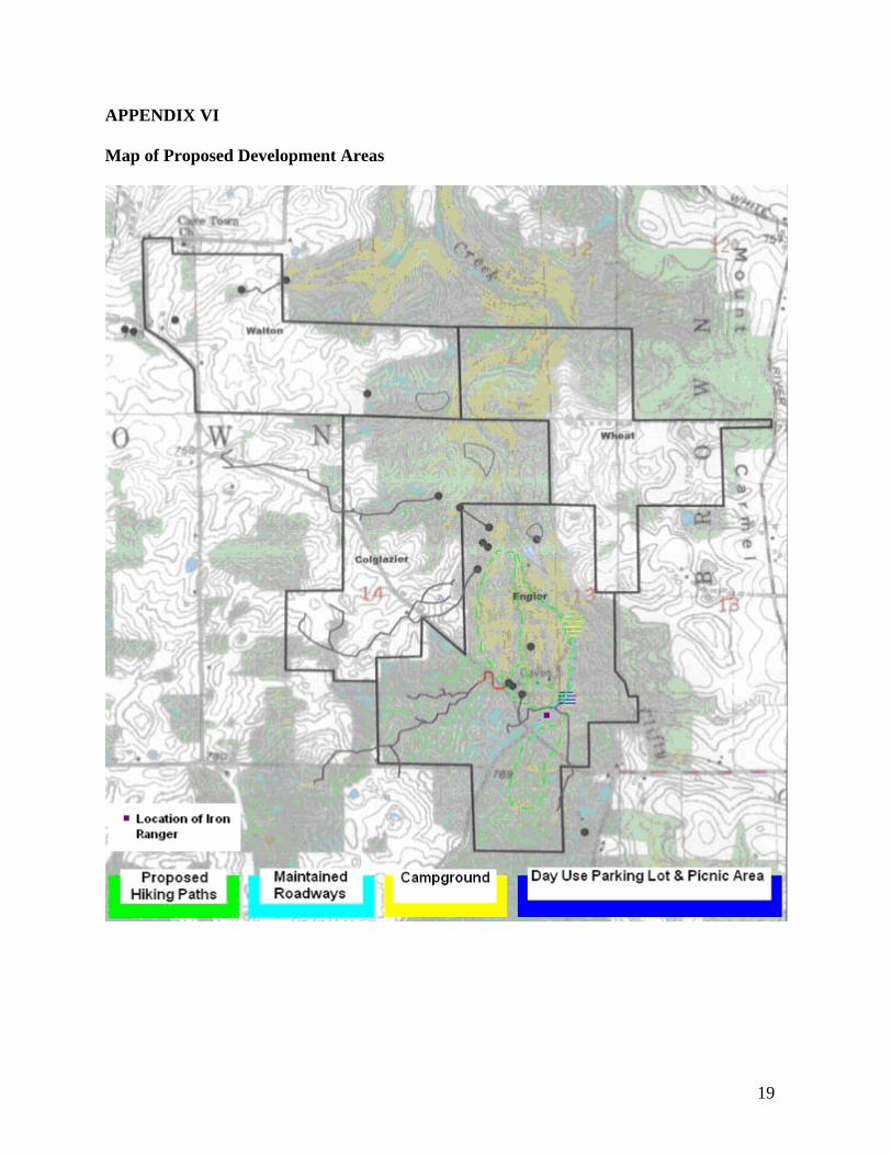
APPENDIX VI Map of Proposed Development Areas