prediction of the probability of large fires in the sydney
TRANSCRIPT

University of WollongongResearch Online
Faculty of Science - Papers (Archive) Faculty of Science, Medicine and Health
2009
Prediction of the probability of large fires in theSydney region of south-eastern Australia usingcomponents of fire weather.R A. BradstockUniversity of Wollongong, [email protected]
J S. CohnNSW Department of Environment & Climate Change
A M. GillCSIRO Plant Industry
M BedwardNSW Department of Environment & Climate Change
C LucasAustralian Bureau of Meteorology
Research Online is the open access institutional repository for the University of Wollongong. For further information contact the UOW Library:[email protected]
Publication DetailsBaker, J. R., Priddel, D., Auld, T. & Keith, D. (2009). Science supporting threatened species conservation. Ecological Management andRestoration, 10 (s1), S145-S145.

Prediction of the probability of large fires in the Sydney region of south-eastern Australia using components of fire weather.
AbstractThe probability of large-fire (>= 1000 ha) ignition days, in the Sydney region, was examined using historicalrecords. Relative influences of the ambient and drought components of the Forest Fire Danger Index (FFDI)on large fire ignition probability were explored using Bayesian logistic regression. The preferred models fortwo areas (Blue Mountains and Central Coast) were composed of the sum of FFDI (Drought Factor, DF = 1)(ambient component) and DF as predictors. Both drought and ambient weather positively affected the chanceof large fire ignitions, with large fires more probable on the Central Coast than in the Blue Mountains. Thepreferred, additive combination of drought and ambient weather had a marked threshold effect on large-fireignition and total area burned in both localities. This may be due to a landscape-scale increase in theconnectivity of available fuel at high values of the index. Higher probability of large fires on the Central Coastmay be due to more subdued terrain or higher population density and ignitions. Climate scenarios for 2050yielded predictions of a 20-84% increase in potential large-fire ignitions days, using the preferred model.
Keywordseastern, australia, prediction, components, probability, fire, weather, large, fires, sydney, region, south
DisciplinesLife Sciences | Physical Sciences and Mathematics | Social and Behavioral Sciences
Publication DetailsBaker, J. R., Priddel, D., Auld, T. & Keith, D. (2009). Science supporting threatened species conservation.Ecological Management and Restoration, 10 (s1), S145-S145.
This journal article is available at Research Online: http://ro.uow.edu.au/scipapers/356
CSIRO PUBLISHING
International Journal of Wildland Fire 2009, 18, 932–943 www.publish.csiro.au/journals/ijwf
Prediction of the probability of large fires in the Sydneyregion of south-eastern Australia using fire weather
R. A. BradstockA,B,E, J. S. CohnC, A. M. GillA,B, M. BedwardC and C. LucasB,D
AFenner School of Environment and Society, The Australian National University, Canberra,ACT 0200, Australia.
BBushfire Co-operative Research Centre, 340 Albert St, East Melbourne, VIC 3002, Australia.CNew South Wales Department of Environment and Climate Change, PO Box 1967,
Hurstville, NSW 2220, Australia.DAustralian Bureau of Meteorology, GPO Box 1289, Melbourne, VIC 3001, Australia.ECorresponding author. Present address: Centre for Environmental Risk Management of Bushfires,University of Wollongong, NSW 2522, Australia. Email: [email protected]
Abstract. The probability of large-fire (≥1000 ha) ignition days, in the Sydney region, was examined using historicalrecords. Relative influences of the ambient and drought components of the Forest Fire Danger Index (FFDI) on largefire ignition probability were explored using Bayesian logistic regression. The preferred models for two areas (BlueMountains and Central Coast) were composed of the sum of FFDI (Drought Factor, DF = 1) (ambient component) and DFas predictors. Both drought and ambient weather positively affected the chance of large fire ignitions, with large fires moreprobable on the Central Coast than in the Blue Mountains. The preferred, additive combination of drought and ambientweather had a marked threshold effect on large-fire ignition and total area burned in both localities. This may be due to alandscape-scale increase in the connectivity of available fuel at high values of the index. Higher probability of large fireson the Central Coast may be due to more subdued terrain or higher population density and ignitions. Climate scenariosfor 2050 yielded predictions of a 20–84% increase in potential large-fire ignitions days, using the preferred model.
Additional keywords: climate change, drought, fire danger, fire weather indices.
Introduction
Large landscape fires can have important environmental, socialand economic consequences (e.g. death and injuries, destructionof buildings, crops and infrastructure; Moreno 1998; Keeley andFotheringham 2001; Gill 2005). Such impacts are often severe inperi-urban environments where large populations abut extensivetracts of flammable vegetation. Although large fires representonly a small proportion of the total number of fires, they typi-cally account for the bulk of area burned in many regions (e.g.Reed and McKelvey 2002). An understanding of the factors thatgovern the incidence and spread of large fires is therefore neededto support effective planning of fire mitigation and suppression,along with planning for ecological and urban interface manage-ment (Amiro et al. 2004). Such an understanding is required notonly to predict their incidence, but also to evaluate how this mayshift under global change.
The incidence and size of fires is influenced by a range of fac-tors, such as ignition sources, fuels, terrain, suppression forcesand weather. In particular, weather is considered to be a signif-icant influence on the incidence of large fires (Flannigan andHarrington 1988; Carrega 1991; Davis and Michaelsen 1995;Gill and Moore 1996, 1998; Mensing et al. 1999; Moritz 2003;Keeley 2004; Peters et al. 2004). Formal relationships betweenthe incidence of large fires and meteorological factors or fire-weather indices have been explored in a variety of locations,
leading to differing conclusions about the relative importanceof different weather components. For example, in Canada, areaburned was positively related to low rainfall (i.e. drought),high temperatures and low relative humidity (Flannigan andHarrington 1988). In coastal California, however, large fireswere largely determined by incidence of autumn foehn windsrather than antecedent rainfall (Keeley 2004). Viegas et al.(1992) and Viegas and Viegas (1994) found area burned inPortugal was related to fuel moisture and seasonal rainfall. Intemperate Australia, drought preceding the fire season, in com-bination with particular meteorological conditions, can result inlarge fires (Foley 1947; Robin and Wilson 1958; Cheney 1976;Cunningham 1984; Gill 1984).
In contrast to drought, which can be regarded as a relativelylong-term influence on fire size, effects of wind, air tempera-ture and humidity at the time of fire are ‘ambient’ drivers of firesize. Studies using fire danger ratings or indices as predictors ofarea burned have highlighted the importance of both the ambi-ent and drought components as drivers (Carrega 1991; Goodrick2002; Preisler et al. 2004). Recent research has highlightedlinks between a changing climate and elevated fire activity inthe northern hemisphere (e.g. Pausas 2004; Flannigan et al.2005; Westerling et al. 2006). These studies have related dif-fering combinations of increases in temperature, length of fireseason and drought to increases in the incidence and area of fire
© IAWF 2009 10.1071/WF08133 1049-8001/09/080932

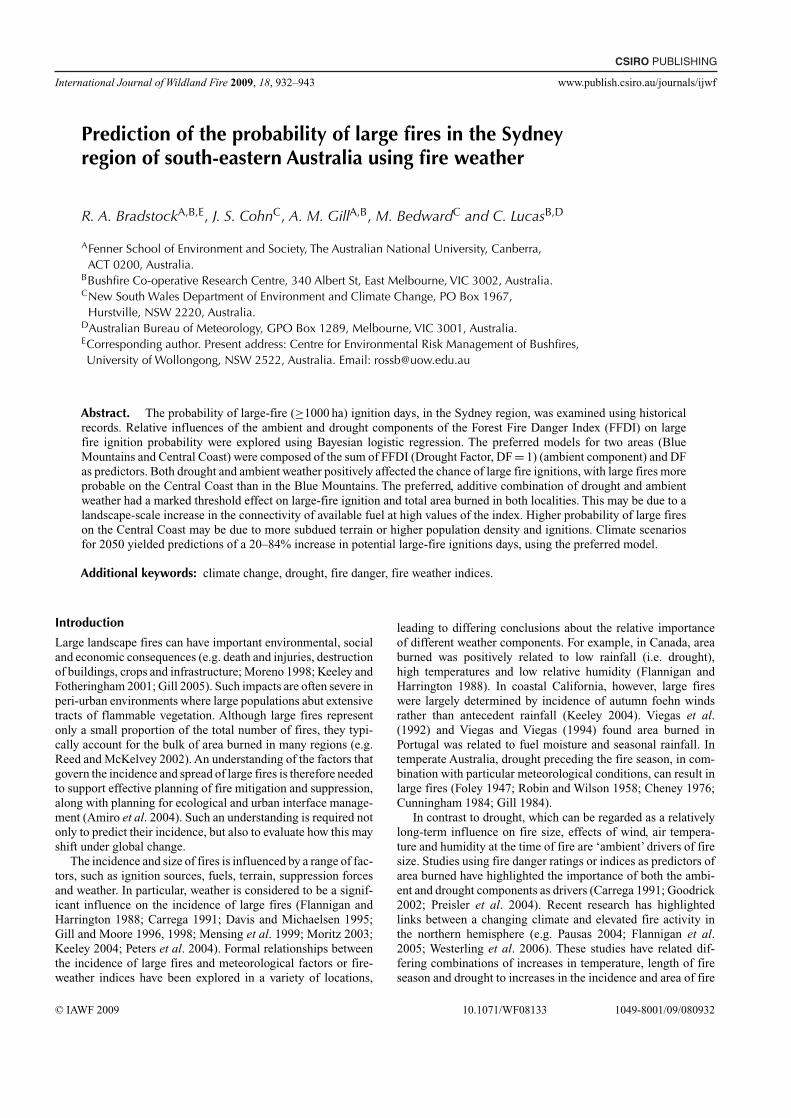
Large fire probability Int. J. Wildland Fire 933
Gosford
Sydney
Study area
CentralCoast andTablelands
Region
Blue Mountainsregion
0 5 10 20
Study regions
National Park estate
30 40 km
Penrith
Bathurst
Legend
Fig. 1. Location of study areas within the greater Sydney region.
in regions ranging from the boreal to temperate Mediterraneantypes.
Increases in fire danger indices reflecting, in turn, elevatedtemperatures, increased evaporation and higher incidence ofdrought have been predicted for a wide range of regions in Aus-tralia under global warming (Williams et al. 2001; Hennessyet al. 2006). Further insights are required to predict the likelyeffects of these shifts in fire-weather on fire regimes inAustralia.A fundamental understanding of the relationship between areaburned and key weather variables offers an empirical basis forpredicting the effects of global warming on fire regimes.
The Sydney basin in south-eastern Australia contains thelargest urban population centre in the nation. Large fires, caus-ing losses of lives and property, are common in the region(Cunningham 1984; Gill and Moore 1996, 1998; Bradstock andGill 2001) owing to the large expanse of natural vegetation withinand around the greater metropolitan area of Sydney. Much ofthis is a complex of sclerophyll vegetation dominated by Euca-lyptus species. Rapid fuel accumulation and high equilibriumfuel loads are a characteristic of this vegetation (Morrison et al.1996). Local combinations of vegetation, terrain and weathercan result in a high probability of uncontrollable fire behaviour(Bradstock et al. 1998). Bradstock and Gill (2001) estimated thatthe probability of destruction of property in the region was a pos-itive non-linear function of McArthur’s Forest Fire Danger Index(FFDI – the fire danger rating system commonly used in tem-perate, forested regions of Australia; Luke and McArthur 1978;Noble et al. 1980). This trend reflected an underlying positiverelationship between incidence of fire and FFDI within majorlandscapes in the region (Bradstock and Gill 2001).
In the present paper, the aims are to:
(i) Examine the effect of both ambient and drought componentsof weather in the Sydney region on the probability of large-fire (≥1000 ha) ignition days;
(ii) Apply derived relationships to estimate the level of change inthe incidence of large fires that could result from predictedchanges in climate by the mid-21st century.
The approach taken differs from many other studies becauseit concentrates on the weather on the day that large-areafires ignite, rather than a correlation between more generalmeasures of weather and final area burned per se. Such anapproach has the advantage of offering a predictive capacityfor management: i.e. an estimation of the chance of a large-fire event beginning on any given day based on its weathercharacteristics.
MethodsStudy areaThe greater Sydney region, in the state of New South Wales,south-eastern Australia, extends from the Hunter Valley in thenorth to Bateman’s Bay in the south and the Blue Mountains inthe west, covering ∼3.6 million ha. The study areas lie withinthis basin to the west and north of Sydney and include respec-tively the Blue Mountains (BM, 1 043 231 ha) and the CentralCoast and Tablelands Regions (CCT, 433 471 ha) as defined byNew South Wales National Parks and Wildlife Service (Fig. 1).National Park estate predominates in both cases. Historical dataon unplanned fire occurrence within these study areas werecompiled from official records. Ignition dates and final areasburnt for the periods 1960–61 to 2003–04 (BM) and 1988–89 to2003–04 (CCT) were collected.These study periods were chosenfor their higher data reliability.
The climate of the study areas is temperate (bounded by34◦20′–33◦00′S latitude, and 149◦50′–151◦35′E longitude) withaverage annual rainfall varying from 600 to 2000 mm. Meanannual temperature ranges from 8.5◦ to 18.5◦C (−2◦ to 8.5◦C,

934 Int. J. Wildland Fire R. A. Bradstock et al.
0
5
10
15
20
25
1960 1965 1970 1975 1980 1985 1990 1995 20000
10
20
30
40
50
60
70
80
0
5
10
15
20
25
1960 1965 1970 1975 1980 1985 1990 1995 20000
10
20
30
40
50
60
70
80
Area burnt (ha � 10 000 year�1)
Large fire ignition year
Number of fires per year
Are
a bu
rnt (
ha �
104
year
�1 ) N
umber of fires per year
Financial year (1 July to 30 June)
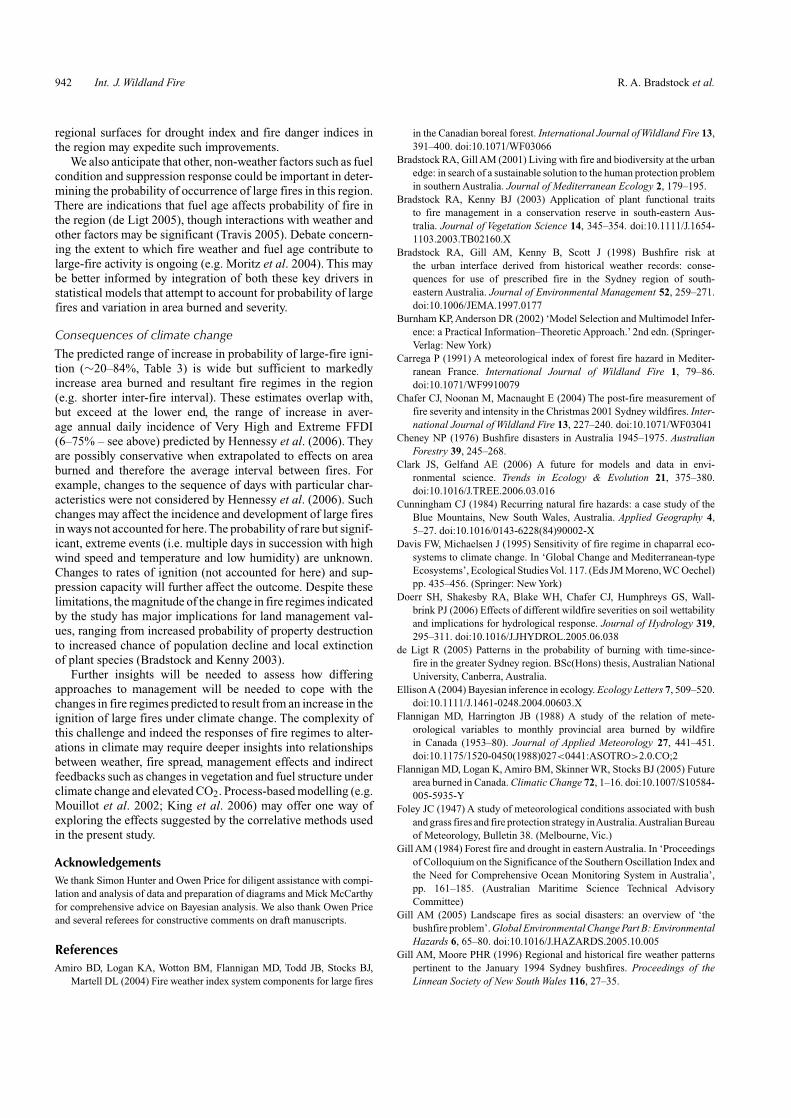
(a)
(b)
Fig. 2. Annual area burned, number of fires and occurrence of years containing large fire ignitiondays in the (a) Blue Mountains (1960–2003); and (b) Central Coast and Tablelands (1988–2003).Years are Australian financial years (e.g. 1960 = 1 July 1960–30 June 1961).
minimum; 20◦–29.5◦C, maximum) (Australian Bureau of Mete-orology). Topography ranges from gently undulating to ruggedplateaux with dissected gorges (0 to 1400 m above sea level).The dominant geology is sandstone. Broad vegetation communi-ties include grasslands, heath, woodlands, dry sclerophyll forestwith pockets of moister forests, and swamps. Dominant trees areAngophora, Eucalyptus and Corymbia spp. (Keith 2004).
Fire-weather in the region is primarily influenced by temper-ate dry, cool to hot westerly airstreams and warm, humid easterlysubtropical airstreams (Luke and McArthur 1978). From 1960to 2003, there has been an increase in the annual number of firesin BM, especially since 1993–94 (Fig. 2a; years are definedas 1 July to 30 June – which encompasses the spring–summerfire season). Both BM and CCT have shared years with largeareas burned: e.g. 1993–94, 1997–98, 2001–02 and 2002–03. InBM, other years with large area burned were 1964–65, 1968–69,1977–78, 1979–80, 1982–83. Over their respective study peri-ods, a total of 800 500 ha burned in BM and 391 253 ha in CCT(Table 1).
Large-fire ignition days were defined as those on which atleast one ignition led to a subsequent burned area of ≥1000 ha(Fig. 2). Small-fire ignition days were all other ignition days(i.e. ignitions resulting in <1000 ha burnt). Predominant igni-tion sources were human, with lightning being a more significantsource of fire in BM than the CCT (NSW Department ofEnvironment and Climate Change, unpubl. data).
Definition of weather indicesThe choice of weather observations and procedures for calcu-lation of FFDI and its components followed the methods ofHennessy et al. (2006). Daily values of maximum FFDI werecalculated from maximum air temperature (T, ◦C), minimumrelative humidity (H, %), maximum wind velocity (V, km h−1)and 24-h precipitation to 0900 hours, using Eqn 1 (Noble et al.1980). FFDI values were capped at a maximum of 100 (see Gillet al. 1987).
FFDI = 2 × exp(−0.450 + 0.987 × ln(DF) − 0.0345
× H + 0.0338 × T + 0.0234 × V) (1)
Precipitation is an input into the calculation of the DroughtFactor (DF) along with the Drought Index (Noble et al. 1980). DFwas calculated using the Keetch–Byram Drought Index (KBDI),(Keetch and Byram 1968) with DF capped at a maximum valueof 10 using Eqn 2 (Noble et al. 1980).
DF = 0.191 × (KBDI + 104) × (N + 1)1.5/
(3.52 × (N + 1)1.5 + P − 1) (2)
where N is the number of days since rain and P is the amount ofprecipitation in the last rain event in mm.
Weather data representative of the BM and CCT districtswere taken from respectively Sydney (Sydney Airport) and

Large fire probability Int. J. Wildland Fire 935
Table 1. Numbers of large (≥1000 ha) and small (<1000 ha) fire ignition days and the corresponding area burned for the Blue Mountains (BM) andCentral Coast and Tablelands (CCT) for their respective study periods
Study area (period) No. days Total days Percentage of days Area burned (ha) Total ha
Ignitions Ignitions Large Small
Large Small Large Small
BM (1960–2003) 51 510 15 692 0.32 3.20 768 223 32 277 800 500CCT (1988–2003) 23 419 5394 0.39 7.76 359 963 31 267 391 320
Williamtown stations (Australian Bureau of Meteorology) anddaily values of KBDI, DF and FFDI were calculated for thehistorical periods 1960–2003 for Sydney and 1988–2003 forWilliamtown. Daily FFDI was then partitioned into relativelylong-term (i.e. drought – DF) and short-term, ambient (FFDIwith effect of DF minimised) components. The latter, dailyambient component was calculated with DF as a value of 1(FFDI(DF = 1)) using Eqn 3 (Noble et al. 1980), thus minimisingthe drought effect and allowing coupled effects of temperature,wind and humidity on large-fire ignition to be explored. Valuesof FFDI(DF = 1) were capped at a maximum of 10.
FFDI(DF = 1) = 2 × exp(−0.450 − 0.0345 × H + 0.0338
× T + 0.0234 × V) (3)
Statistical modelling
Trends in large-fire ignition days in relation to the variousweather indices and their combinations (i.e. DF, FFDI(DF = 1),FFDI and FFDI(DF = 1) + DF – see below) were exploredgraphically. Large-fire ignition day probability was initially cal-culated for graphical exploration in ‘bins’(single unit size for DF,FFDI(DF = 1) and FFDI(DF = 1) + DF; decile size for FFDI)for each index (i.e. large fire ignition probability = number oflarge fire ignition days in each bin/total days in each bin in thetime series). Non-binned (i.e. continuous) data were used forstatistical modelling.
Bayesian logistic regression, with uninformed priors (no priordata), was used to investigate the relationship between large-fireignition day probability and differing weather components ineach study area. The advantage of a Bayesian approach is thatthe full range of variability in parameter estimates can be accom-modated in a preferred model (Ellison 2004; Clark and Gelfand2006), resulting in a fulsome representation of uncertainty andvariability in model predictions.
Four logistic models were fitted to the data from eachstudy area using WinBUGS ver. 1.4 (Spiegelhalter et al.2003). The models tested independent effects of DF andFFDI(DF = 1) as well as their product (i.e. FFDI) and theirsum (FFDI(DF = 1) + DF) (Table 2). Explanatory variableswere centred by subtracting the mean, to reduce correlationbetween successive samples. Posterior probability distributionson the parameter estimates were sampled from normal distribu-tions. Parameter estimates for the models were based on 20 000samples after excluding an initial 2000.
The Deviance Information Criterion (DIC) was used to selecta preferred model for each study area (Spiegelhalter et al. 2003).The change in DIC is indicative of the superiority of the modelsi.e. values less than three are the better models and those >10
indicate inferior ones. Low values of DIC indicate parsimoniousmodels (i.e. small number of explanatory variables) with a highlevel of fit to the data. The performance of the models as predic-tors of large-fire probability was tested by calculation of the ROC(Receiver Operator Curve) and estimation of the area under thecurve (AUC). The ROC provides an estimation of performanceof binary models based on the ratio of true to false positive pre-dictions (Burnham and Anderson 2002). AUC values close to 1indicate a model with a high capacity for successful prediction,whereas a value of 0.5 indicates a model that does not performbetter than a random coin toss. A predictive, probability surfacefor large-fire occurrence was derived for the preferred modelusing least-squares regression (STATISTICA, version 7.1).
Effects of climate changeHennessy et al. (2006) estimated a range of scenarios, using avariety of Global Circulation Models (GCMs), for effects of cli-mate change on fire danger and drought indices for a variety ofweather stations within south-eastern Australia. Hennessy et al.(2006) predicted a general increase (relative to contemporaryclimate) in average annual sum of daily FFDI in the order of5–25% and 8–30% for 2050 using two differing GCMs (CCAMMark 2 and CCAM Mark 3 respectively). Hennessy et al. (2006)also provided estimates of change in daily FFDI: for example,the annual frequency of days with Very High to Extreme FFDI in2050 for Sydney was predicted to rise by 6–75% from a currentannual average of 8.7 (Hennessy et al. 2006). These predictionswere generated from an adjusted 31-year time series of contem-porary daily data (Hennessy et al. 2006), reflecting effects of2050 scenarios on the individual parameters (e.g. rainfall, tem-perature, humidity, wind speed) used in the calculation of dailyFFDI.
Effects of climate change on the frequency of large-fire daysand total area burned were estimated using the highest andlowest scenarios of change in FFDI and drought indices for2050 provided by Hennessy et al. (2006) based on the CCAMMark 2 and 3 predictions. The preferred statistical model (seeabove) was used to generate threshold values of FFDI(DF = 1)and DF that corresponded to differing levels of predicted largefire probability (e.g. 10, 20, 30%). The number of days ator above each threshold was calculated for the contemporary31-year time series of daily weather data (1974 to 2005) forSydney and Williamtown (representing BM and CCT respec-tively – see above). A similar calculation was then performedon the adjusted daily weather data, representing the highest andlowest 2050 scenarios of climate change produced by Hennessyet al. (2006). Differences, resulting from climate change, in thenumber of days corresponding to a particular level of predicted,

936 Int. J. Wildland Fire R. A. Bradstock et al.
Table 2. Bayesian logistic regression models (regression parameter estimates for mean and Bayesian credible intervals) for prediction of effects ofweather components (FFDI, DF, FFDI(DF = 1) – see text) on the probability of large fire ignition days in the Blue Mountains (BM) and Central Coast
and Tablelands (CCT)Deviance Information Criterion (DIC) compares models, which are ordered from best to worst (see Methods). Parameter a = slope; b = y-intercept for weathercomponent 1; c = y-intercept for weather component 2. Model performance is indicated by estimated area (AUC) under the Receiver Operator Curve (ROC)
Weather component Credible intervals
Mean 2.5% 97.5% DIC �DIC AUC
a b c a b c a b c
BMFFDI(DF = 1) + DF −7.80 0.55 0.61 −8.63 0.43 0.39 −7.10 0.68 0.84 560.68 0 0.87FFDI −6.24 0.08 −6.60 0.07 −5.90 0.10 587.15 26.47 0.84FFDI(DF = 1) −6.68 0.67 −7.09 0.56 −6.30 0.79 607.03 46.35 0.79DF −7.21 0.70 −8.06 0.49 −6.52 0.95 613.98 53.30 0.84
CCTFFDI(DF = 1) + DF −10.08 0.61 1.30 −12.62 0.46 0.75 −7.96 0.76 1.91 187.41 0 0.98FFDI −6.36 0.09 −7.02 0.07 −5.78 0.10 209.98 20.57 0.96FFDI(DF = 1) −6.30 0.71 −6.94 0.57 −5.73 0.85 220.53 33.12 0.92DF −8.87 1.25 −10.88 0.89 −7.18 1.75 239.24 51.83 0.93
large-fire probability in BM and CCT were generated by compar-ing the results yielded from the contemporary and future (2050)weather time series data (high and low scenarios).
ResultsEffects of weather on large firesThe daily frequency of each index (i.e. FFDI, DF andFFDI(DF = 1)) declined at higher values (Fig. 3). DF tendedtoward a bimodal distribution (Fig. 3). The number of large-fireignition days was relatively low (Table 1), but the resultant areaburnt by such fires was very high in both areas: i.e. large-fireignition days accounted for 96 and 92% of total area burnt inBM and CCT over the respective study periods.
There were positive, non-linear trends in percentages of large-fire ignition days in relation to all weather indices (Fig. 4). Ingeneral, the percentage of large-fire ignition days (Fig. 4) wassmall (e.g. <0.1%) at low values of the weather indices in bothareas. High percentages of large-fire ignition days (e.g. >20%)occurred at high values of each index. The exception was DF,where the overall range of percentage occurrence of large-fireignition days was low (<10%) in both areas. Percentage of large-fire ignition days was generally higher in CCT than BM.
Drought (DF) had an apparent threshold effect on large-fireignition in both areas (Fig. 4a), i.e. large fires only occurredon days where DF > 7 in CCT and mostly above DF > 6 forBM. Large-fire ignition days occurred across a broad rangeof ambient weather (FFDI(DF = 1)) and FFDI in both areas(Fig. 4b, c), though trends in percentage occurrence were vari-able. Trends in percentage of large-fire ignition days in relationto FFDI(DF = 1) + DF were less variable (Fig. 4d). The per-centage of large-fire ignition days increased markedly whenFFDI(DF = 1) was >8 (Fig. 4c) and FFDI(DF = 1) + DF > 14in both areas.
Statistical modellingThe best model for both study areas contained the additive effectsof the ambient (FFDI(DF = 1)) and drought (DF) componentsof FFDI (Table 2). For both study areas, the parameter estimates
for FFDI (i.e. the multiplicative effects of drought and ambientcomponents) were significant but this model accounted for asmaller change in the DIC (Table 2) than the additive model,as was expected given trends in the raw data (Figs 3, 4). ROCandAUC values followed a similar trend, with the additive modelyielding highest values. The overall ROC and AUC values for allmodels were relatively high, with the preferred, additive modelyielding the maximum (i.e. close to 1), indicating a high capacityfor successful prediction of large-fire ignition day probability.
Overall, predicted large-fire ignition day probability basedon the preferred mean additive model was constrained by bothdrought and ambient weather in both areas (Fig. 5a), but therewas differential sensitivity to these factors between the areas.Large-fire ignition days were predicted (mean) to be absent underlow to intermediate values (e.g. 0–6) of both weather componentsin both areas. Mean predicted probability was less constrainedby ambient weather and more constrained by drought in CCTcompared with BM, based on the relative position of the 0.1 prob-ability contour (Fig. 5a). Mean predicted probability of large-fireignition days increased with FFDI(DF = 1) and DF, but was sen-sitive to change at high values of both independent variables(Fig. 5a). Overall mean predicted large-fire ignition probabilitywas higher at high values of both weather components in CCTcompared with BM. Thus CCT predictions were more sensitiveto variations in both ambient and drought components at highvalues (Fig. 5a).
The preferred model, FFDI(DF = 1) + DF, can be used as alarge fire probability index (LFPI) with a range of 20, given thatboth components had a capped maximum value of 10 (see aboveand Fig. 5). The minimum value of LFPI for each mean large-fire probability decile (Table 3) was estimated from the interceptof each decile with the axes of either DF or FFDI(DF = 1) (i.e.where the value of either index is zero – Fig. 5a). Minimum LFPIfor each decile of probability was lower for CCT than BM (Fig. 5,Table 3). For example, there was a >50% mean chance of a large-fire ignition day on the Central Coast when LFPI was >18.0 (i.e.FFDI(DF = 1) ≥ 8, DF > 9.1) and in the Blue Mountains whenLFPI was >19.4 (i.e. FFDI(DF = 1) ≥ 9.4, DF ≥ 9.6). Over the

Large fire probability Int. J. Wildland Fire 937
02000
400060008000
10 00012 000
14 00016 000
10 30 50 70 90
0
500
1000
1500
2000
2500
3000
1 2 3 4 5 6 7 8 9 10
Blue Mountains
Num
ber
of d
ays
Central Coast and Tablelands
0
200
400
600
800
1000
1 2 3 4 5 6 7 8 9 10
FFDI
0
1000
2000
3000
4000
5000
10 30 50 70 90
FFDI(DF � 1)
0
2000
4000
6000
8000
10 000
12 000
1 2 3 4 5 6 7 8 9 100
500
100015002000
25003000
35004000
1 2 3 4 5 6 7 8 9 10
DF (capped)DF (capped)
FFDI
FFDI(DF � 1)
Num
ber
of d
ays
Num
ber
of d
ays
Fig. 3. Frequency of categories of weather indices from Sydney and Williamtown, used respectively for analysis of BlueMountains (1960–2003) and Central Coast (1988–2003) fire data. Weather indices include Drought Factor (DF), Forest FireDanger Index (FFDI) with DF = 1 (FFDI(DF = 1)) and FFDI.
period 1974–2003 (10 957 days), these conditions (mean pre-dicted 50% chance of a large-fire ignition day) were rare, beingmet on 0.01% days (12 days total) on the Central Coast and∼0.001% days (1 day total) in the BM. Lower probabilities oflarge-fire ignition occurred on appreciably more days in bothareas (Table 3).
There was considerable uncertainty around the mean predic-tions, indicated by the Bayesian credible intervals (Fig. 5b, c)and their effect on the LFPI. For example, at the upper confi-dence limit (97.5%), the 50% LFPI was 16.6 for CCT and 17.8for BM (Fig. 5b). At the lower confidence limit, the maximumlarge-fire probability dropped to ∼0.5 for CCT and 0.3 for BM(Fig. 5c).
Effects of climate changeThe climate change scenarios for 2050 substantially increasedthe predicted incidence of days suitable for large-fire ignitions,
based on minimum LFPI (Table 3). The high-climate-changescenario, as expected, produced a greater increase in predictedlarge-fire ignition probability than the low-climate-change sce-nario (Hennessy et al. 2006). The average increase in predictedminimum LFPI ranged from 20 (BM) to 34% (CCT) under thelow-climate-change scenario, and from 67 (BM) to 84% (CCT)under the high-climate-change scenario (averages were calcu-lated across all LFPI deciles, yielding values of ≥5 days undercontemporary climate).
DiscussionEffects of drought and ambient weatherThe positive relationship between percentage of large-fire igni-tion days and the differing weather indices (Fig. 4) reflected therelative rarity of small fires on days with higher values of eachindex, as well as the overall rarity of such weather conditions(Fig. 3). The exception to this was DF, where the percentage

938 Int. J. Wildland Fire R. A. Bradstock et al.
01 3 5 7 9
10
30
50
70
DF
Per
cent
age
of d
ays
with
larg
e fir
es
1 2 3 4 5 6 7 8 90
10
30
50
70
FFDI(DF � 1)
Per
cent
age
of d
ays
with
larg
e fir
es
0
10
30
50
70
Per
cent
age
of d
ays
with
larg
e fir
es
2 4 6 8 12 16 20
FFDI(DF � 1) � DF
0
10
30
50
70
Per
cent
age
of d
ays
with
larg
e fir
es
10 30 50 70 90
FFDI
(a) (b)
(c) (d)
Fig. 4. Percentage occurrence of large fire ignition days in relation to differing weather indices (a) Drought Factor (DF);(b) Forest Fire Danger Index (FFDI); (c) ambient weather (FFDI(DF)); (d) additive model (FFDI(DF = 1) + DF) (see text)in the Blue Mountains (BM 1960–2003) and Central Coast and Tablelands (CCT 1988–2003).
range of large-fire ignition days was low, owing to the bimodaldistribution of daily DF (Fig. 3). Drought, and to a lesser degreeambient weather, had threshold effects on large-fire ignitionday percentage (Fig. 4a, c). The addition of drought and ambi-ent components (FFDI(DF = 1) + DF) captured these non-lineartrends (Fig. 4d). Large-fire ignition day probability followed aclearer trend in response to this additive index, compared withFFDI (multiplicative effect) (Fig. 4b, d). This was reflected inthe preferred statistical model (Fig. 5, Table 2).
Drought and ambient weather therefore had interdependenteffects on large-fire ignition. Ignition of large fires was onlylikely in representative landscapes of the Sydney region whendrought and ambient conditions of at least ‘moderate’ sever-ity (e.g. DF > 5, FFDI(DF = 1) > 5, LFPI > 10) co-occurred.Ambient weather (higher temperatures and wind speeds, lowerhumidity) can realise the opportunity created by drought for largefires to develop if ignitions occur.
The results of the present study quantify trends partiallyexplored in other case studies in the region. Cunningham (1984)found that major fire seasons of fires in the Blue Mountainsbefore 1983 resulted from one or more wet seasons followed by adry spring, accompanied by specific ambient weather conditions.Large fires in January 1994 affected the Sydney region, resultingin major property loss. These fires and the bulk of resultant prop-erty damage occurred under conditions of extreme daily FFDI,though a comparison of wind and drought contributions to FFDIon these days showed no unprecedented values of these variables
(Gill and Moore 1996). The contribution of both drought andambient weather were causal to these fires. Similar circum-stances prevailed when large fires burned in the region in Decem-ber 2001 (Chafer et al. 2004; Hammill and Bradstock 2006).
Gill (1984) hypothesised that droughts, because of theirregional scale, predispose large areas to fire through drying offuel, an increase in fuel load and removal of natural barriersto fire spread. Gill (1984) also noted that when droughts areprolonged, there is an increased chance of coincidence of otherweather factors that enhance the spread of fire. The overall prob-ability of large fires therefore increases.The results of the presentstudy confirm and extend this hypothesis through quantificationof the interactive contributions of drought and ambient weatheron probability of ignition of large fires.
Influences of weather on fuel connectivityThreshold effects of drought and ambient weather on probabilityof large-fire ignition (Fig. 4) are also evident when cumulativearea burned is examined for the study period in both areas inrelation to the additive model (i.e. calculated from the final areaburned and corresponding FFDI data for each ignition day in theappropriate record – Fig. 6). These results (Fig. 6) are consistentwith conclusions from other studies of non-linear distributionsof fire area (Reed and McKelvey 2002; Peters et al. 2004), i.e.that weather factors operating at meso and macro spatial scaleshave a predominant influence on the development of large firesthrough influences on the connectivity of available fuel.

Large fire probability Int. J. Wildland Fire 939
Central Coast and Tablelands
0 2 4 6 8 10
FFDI(DF � 1)
0
2
4
6
8
10
DF
0
0.1
0.2
0.3
0.5
0
(a) Mean
0 2 4 6 8 10
FFDI(DF � 1)
0
2
4
6
8
10D
F
0.1
0.2
0.3
0.4
0.5
Central Coast and Tablelands
0
0
0.1
0.2
0.3
0.5
0.7
0.4
0 2 4 6 8 10
FFDI(DF � 1)
0
2
4
6
8
10D
F
00.1
0.2
0.3
0.4
0.6
0.5
0 2 4 6 8 10
FFDI(DF � 1)
0
2
4
6
8
10
DF
(b) 97.5% credible interval
Central Coast and Tablelands
0
0.1
0.2
0
0.30.4
0 2 4 6 8 10
FFDI(DF � 1)
0
2
4
6
8
10
DF
0
0.1
0.2
0.3
0 2 4 6 8 10
FFDI(DF � 1)
0
2
4
6
8
10
DF
(c) 2.5% credible interval
Blue Mountains
Blue Mountains
Blue Mountains
Fig. 5. Prediction of probability of large fire ignition days in relation to drought (Drought Factor (DF) and ambient weather(FFDI(DF = 1))) (FFDI, Forest Fire Danger Index) indices based on historical data from Blue Mountains (1960–2003) andCentral Coast and Tablelands (1988–2003). Mean (a), 95% (b) and 2.5% (c) credible intervals are given (see Methods).

940 Int. J. Wildland Fire R. A. Bradstock et al.
Table 3. Relationships between mean predicted daily probability of large fire ignition days (LFPI – see text) Drought Factor (DF) and ambientweather (FFDI(DF = 1)), under current (1974–2003) and predicted (Hennessy et al. 2006) 2050 climate (low and high scenarios – see text) for the
Blue Mountains and Central Coast
Predicted large fire Minimum Number of days for current (1974–2003) and predictedignition probability DF FFDI(DF = 1) LFPI 2050 climate (percentage increase for 2050)
Decile Current 2050 Low 2050 High
Blue Mountains0.1 5.0 4.9 14.9 34 40 (18) 56 (65)0.2 6.6 6.4 16.4 13 16 (23) 22 (69)0.3 7.6 7.5 17.5 4 6 (50) 8 (100)0.4 8.6 8.5 18.5 3 3 (0) 4 (33)0.5 9.6 9.4 19.4 1 1 (0) 3 (200)
Central Coast0.1 6.6 3.8 13.8 135 162 (20) 204 (51)0.2 7.4 5.1 15.1 70 83 (19) 102 (46)0.3 8.1 6.2 16.2 39 46 (18) 66 (69)0.4 8.7 7.2 17.2 23 29 (26) 35 (52)0.5 9.1 8.0 18.0 12 17 (58) 25 (108)0.6 9.5 8.8 18.8 5 8 (60) 14 (180)0.7 9.8 9.7 19.7 4 5 (25) 8 (100)
The thresholds in large-fire ignition (Fig. 4) and resultantcumulative area burned in relation to DF (Fig. 6) may represent astate-transition in landscape-level fuel connectivity, determinedprimarily by fuel moisture. For values above the threshold, thelandscape may enter a state of potential high flammable con-nectivity where natural controls on fire size break down andwhere the size of fire will be strongly affected by the ambientcomponent of weather. Such a hypothesis is consistent with thegeomorphology of the region: the study landscapes are elevatedsandstone plateaux dissected by complex stream systems, oftenresulting in deep canyons with steep sides (Doerr et al. 2006).Thus topography is diverse, leading to strong disjunctions in fueland complex aspect effects on fuel moisture. We hypothesise thatin the absence of drought, fires are relatively small because of thenatural variations in continuity of available fuel imposed by thehigh variation in terrain. In particular, in non-drought conditions,fuel in sheltered southerly and easterly aspects is often too moistto burn. Combined with slope effects, these may impose signif-icant natural barriers to the spread of fires, even when ambientconditions are relatively severe. Such factors are known locallyto complement suppression by providing natural containmentlines for burning-out operations and prescribed fires.
When drought occurs, these natural controls on fire sizemay begin to break down, resulting in greater fuel connec-tivity – effectively a state-transition that increases the spatialscale over which available fuel becomes highly connected. Firesmay therefore tend to be less naturally constrained and effec-tive containment opportunities will diminish. When drought isabsent, effects of ambient weather are often insufficient for fireto bridge discontinuities. High wind speed may partly allowfires to overcome discontinuities in fuel at landscape scales,via long-distance propagation of embers and ignition of spotfires. This may explain why some large fires are possible (lowprobability) at low values of DF and moderate to high values ofFFDI(DF = 1) (Figs 4, 5). Such a hypothesis is testable throughmeasurement of fuel moisture as a function of slope and aspectcombinations under varying degrees of drought. Retrospective
analyses of fire perimeters and their relationship between thesefactors may provide further corroboration.
This hypothesis could partly explain the greater sensitivity oflarge-fire ignition probability in CCT compared with BM (Figs4–6). Although there are similarities in geomorphology betweenthese areas, terrain in CCT is substantially more subdued thanin BM, where relief and maximum elevation are greater. Thuspostulated natural controls on fuel connectivity may be lessrestrictive and break down more readily in CCT.
In other temperate ecosystems, varying emphases have beenplaced on drought v. ambient conditions (e.g. wind) as princi-pal drivers of large fires. These contrasting and varied emphasesneed resolution. Gill et al. (2002) suggested that interactions offuel type and climate (a function of latitude and other ecosystemattributes) plus the timing of events that altered the spatial con-nectivity of fuel can account for the diverse range of fire regimesthat prevail across the Australian continent. They distinguisheda continuum, in the temperate portion of the continent, spannedby arid and mesic systems. At the arid end of this spectrum, sur-face fuels that are primarily ephemeral (composed principallyof herbs and grasses) predominate, while at the mesic end, litterfuels composed of the foliage of perennial plants and exhibitingregular patterns of accumulation predominate. In arid systems,fuel availability is limited by water availability and its effectson plant germination and growth, whereas in mesic systems,fuel accumulation is relatively rapid and the availability of fuelfor burning is constrained chiefly by its moisture content. Fireweather (both drought and ambient components) is not limitingat the arid end whereas fuel is. In contrast at the mesic end, fueltends not to be limiting but fire weather can be. In the lattercase, the occurrence of drought is crucial to fuel availability viaeffects on fuel moisture.
The Sydney region, along with other ecosystems dominatedby forests or shrublands at temperate latitudes, is at the mesicend of this spectrum. If drought is the precursor of large fires,then their occurrence will governed by the frequency of droughtover large spatial scales. In temperate Mediterranean-type

Large fire probability Int. J. Wildland Fire 941
20
200
400
600
800
0
100
200
300
400
4 6 8 12 16 20
2 4 6 8 12 16 20
FFDI(DF � 1) � DF
FFDI(DF � 1) � DF
Cum
ulat
ive
area
bur
nt (
1000
ha)
Cum
ulat
ive
area
bur
nt (
1000
ha)
(a)
(b)
Fig. 6. Relationships between cumulative area burned andFFDI(DF = 1) + DF (DF, Drought Factor; FFDI, Forest Fire DangerIndex) for (a) Blue Mountains (BM, 1960–2003) and (b) Central Coast andTablelands (CCT, 1988–2003).
ecosystems with a pronounced seasonal summer drought, theconditions necessary for large fires to develop are present everyyear. In other temperate systems that lack a regular pattern ofsummer drought (e.g. the Sydney region), appropriate droughtconditions occur less frequently and more irregularly. This mayexplain why wind speed (an ambient weather component) in Cal-ifornian shrublands (Mediterranean climate with annual summerdrought) emerges as the principal determinant of fire size (e.g.Keeley 2004). Thus year-to-year variations in ambient weather(i.e. high wind-speed events) in that environment will havegreatest effect on area burned by large fires. By contrast, in a tem-perate, non-Mediterranean system such as the Sydney region,interannual or even interdecadal variations in drought are likelyto have a large effect on area burned, in concert with ambientweather.
Study limitations and consequences for managementThe results provide a quantitative basis for predicting the chanceof significant fire activity in the region and may be used to
refine planning and preparedness based on short-to-medium-term weather forecasting. Existing systems for estimating FFDIcould be used for this purpose via an additive reformulation of itscomponents to predict large fire ignition probability (i.e. LFPI –Fig. 5).
Use of an index of this kind must be tempered by appreciationof limitations in the data and analyses. First, the temporal recordof fire used in the study is limited – particularly for CCT. Moredata could be obtained from archives of remote sensing, butthe extent to which this approach may augment the record iscurrently unknown.
Second, ignition of large fires during the study period mayhave changed owing to human population changes (ignitionsources) and changes in fire management practices (i.e. preven-tion and suppression). These are not considered in the analysisand may contribute to uncertainty in consequent predictions.This study did not attempt to examine influences of varying igni-tion rates on large-fire probability in time and space. Effects ofweather and ignition rates and sources were confounded; hence,the probability of large fires in each region reflected inherentignition syndromes and the average influence of any historicalchanges in these syndromes. Trends in the data could thereforebe biased. For example, the higher probability of large fires inCCT and BM may be partly due to the higher population den-sity and thus higher rates of anthropogenic ignition in the CCTarea (R. A. Bradstock, J. S. Cohn, A. M. Gill, M. Bedward andC. Lucas, unpubl. data). High numbers of ignitions may over-whelm suppression capacity, leading to a large area burned underfavourable weather. Data limitations prevented further examina-tion of this effect in this study. Further insights into ignitionlevels on days with favourable conditions for large fires arerequired.
Third, the approach does not discriminate between the numberof ignitions on an individual day that result in a large area burned,nor does it attempt to more tightly link the weather indices toarea burned.This is partly due to data limitations (i.e. insufficientsamples of days with differing ignition numbers). Additionally,this limitation results in a relatively coarse representation of theeffect of ambient weather in the analysis (i.e. only on day ofignition). In some cases, the area burned on subsequent dayswas known to contribute substantially to the final total (R. A.Bradstock, J. S. Cohn, A. M. Gill, M. Bedward and C. Lucas,unpubl. data). Such data were not available, however, for allfires, thus precluding the use of a more carefully targeted daily,ambient weather estimate.
Despite these limitations, we suggest that the approach hasvalue for short-to-medium-term prediction of significant fires inthe region. Cautious use of LFPI may provide impetus for furtherrefinement to overcome these limitations. We emphasise that theconfidence intervals around the mean are wide (Fig. 5), in partowing to the use of data from two weather stations as a predictorof fire activity over a large spatial scale, along with limitationsoutlined above. These variations would need to be accounted forin any predictive use of LFPI. Local variations in all weathercomponents are likely to account for a substantial part of thevariation inherent in the model. We anticipate that the key rela-tionships between weather and probability of large fires (Fig. 5)would have substantially less uncertainty if in situ weather datawere used to construct the models. The future availability of
942 Int. J. Wildland Fire R. A. Bradstock et al.
regional surfaces for drought index and fire danger indices inthe region may expedite such improvements.
We also anticipate that other, non-weather factors such as fuelcondition and suppression response could be important in deter-mining the probability of occurrence of large fires in this region.There are indications that fuel age affects probability of fire inthe region (de Ligt 2005), though interactions with weather andother factors may be significant (Travis 2005). Debate concern-ing the extent to which fire weather and fuel age contribute tolarge-fire activity is ongoing (e.g. Moritz et al. 2004). This maybe better informed by integration of both these key drivers instatistical models that attempt to account for probability of largefires and variation in area burned and severity.
Consequences of climate changeThe predicted range of increase in probability of large-fire igni-tion (∼20–84%, Table 3) is wide but sufficient to markedlyincrease area burned and resultant fire regimes in the region(e.g. shorter inter-fire interval). These estimates overlap with,but exceed at the lower end, the range of increase in aver-age annual daily incidence of Very High and Extreme FFDI(6–75% – see above) predicted by Hennessy et al. (2006). Theyare possibly conservative when extrapolated to effects on areaburned and therefore the average interval between fires. Forexample, changes to the sequence of days with particular char-acteristics were not considered by Hennessy et al. (2006). Suchchanges may affect the incidence and development of large firesin ways not accounted for here.The probability of rare but signif-icant, extreme events (i.e. multiple days in succession with highwind speed and temperature and low humidity) are unknown.Changes to rates of ignition (not accounted for here) and sup-pression capacity will further affect the outcome. Despite theselimitations, the magnitude of the change in fire regimes indicatedby the study has major implications for land management val-ues, ranging from increased probability of property destructionto increased chance of population decline and local extinctionof plant species (Bradstock and Kenny 2003).
Further insights will be needed to assess how differingapproaches to management will be needed to cope with thechanges in fire regimes predicted to result from an increase in theignition of large fires under climate change. The complexity ofthis challenge and indeed the responses of fire regimes to alter-ations in climate may require deeper insights into relationshipsbetween weather, fire spread, management effects and indirectfeedbacks such as changes in vegetation and fuel structure underclimate change and elevated CO2. Process-based modelling (e.g.Mouillot et al. 2002; King et al. 2006) may offer one way ofexploring the effects suggested by the correlative methods usedin the present study.
AcknowledgementsWe thank Simon Hunter and Owen Price for diligent assistance with compi-lation and analysis of data and preparation of diagrams and Mick McCarthyfor comprehensive advice on Bayesian analysis. We also thank Owen Priceand several referees for constructive comments on draft manuscripts.
ReferencesAmiro BD, Logan KA, Wotton BM, Flannigan MD, Todd JB, Stocks BJ,
Martell DL (2004) Fire weather index system components for large fires
in the Canadian boreal forest. International Journal of Wildland Fire 13,391–400. doi:10.1071/WF03066
Bradstock RA, Gill AM (2001) Living with fire and biodiversity at the urbanedge: in search of a sustainable solution to the human protection problemin southern Australia. Journal of Mediterranean Ecology 2, 179–195.
Bradstock RA, Kenny BJ (2003) Application of plant functional traitsto fire management in a conservation reserve in south-eastern Aus-tralia. Journal of Vegetation Science 14, 345–354. doi:10.1111/J.1654-1103.2003.TB02160.X
Bradstock RA, Gill AM, Kenny B, Scott J (1998) Bushfire risk atthe urban interface derived from historical weather records: conse-quences for use of prescribed fire in the Sydney region of south-eastern Australia. Journal of Environmental Management 52, 259–271.doi:10.1006/JEMA.1997.0177
Burnham KP, Anderson DR (2002) ‘Model Selection and Multimodel Infer-ence: a Practical Information–Theoretic Approach.’ 2nd edn. (Springer-Verlag: New York)
Carrega P (1991) A meteorological index of forest fire hazard in Mediter-ranean France. International Journal of Wildland Fire 1, 79–86.doi:10.1071/WF9910079
Chafer CJ, Noonan M, Macnaught E (2004) The post-fire measurement offire severity and intensity in the Christmas 2001 Sydney wildfires. Inter-national Journal of Wildland Fire 13, 227–240. doi:10.1071/WF03041
Cheney NP (1976) Bushfire disasters in Australia 1945–1975. AustralianForestry 39, 245–268.
Clark JS, Gelfand AE (2006) A future for models and data in envi-ronmental science. Trends in Ecology & Evolution 21, 375–380.doi:10.1016/J.TREE.2006.03.016
Cunningham CJ (1984) Recurring natural fire hazards: a case study of theBlue Mountains, New South Wales, Australia. Applied Geography 4,5–27. doi:10.1016/0143-6228(84)90002-X
Davis FW, Michaelsen J (1995) Sensitivity of fire regime in chaparral eco-systems to climate change. In ‘Global Change and Mediterranean-typeEcosystems’, Ecological StudiesVol. 117. (Eds JM Moreno, WC Oechel)pp. 435–456. (Springer: New York)
Doerr SH, Shakesby RA, Blake WH, Chafer CJ, Humphreys GS, Wall-brink PJ (2006) Effects of different wildfire severities on soil wettabilityand implications for hydrological response. Journal of Hydrology 319,295–311. doi:10.1016/J.JHYDROL.2005.06.038
de Ligt R (2005) Patterns in the probability of burning with time-since-fire in the greater Sydney region. BSc(Hons) thesis, Australian NationalUniversity, Canberra, Australia.
Ellison A (2004) Bayesian inference in ecology. Ecology Letters 7, 509–520.doi:10.1111/J.1461-0248.2004.00603.X
Flannigan MD, Harrington JB (1988) A study of the relation of mete-orological variables to monthly provincial area burned by wildfirein Canada (1953–80). Journal of Applied Meteorology 27, 441–451.doi:10.1175/1520-0450(1988)027<0441:ASOTRO>2.0.CO;2
Flannigan MD, Logan K, Amiro BM, Skinner WR, Stocks BJ (2005) Futurearea burned in Canada. Climatic Change 72, 1–16. doi:10.1007/S10584-005-5935-Y
Foley JC (1947) A study of meteorological conditions associated with bushand grass fires and fire protection strategy inAustralia.Australian Bureauof Meteorology, Bulletin 38. (Melbourne, Vic.)
Gill AM (1984) Forest fire and drought in eastern Australia. In ‘Proceedingsof Colloquium on the Significance of the Southern Oscillation Index andthe Need for Comprehensive Ocean Monitoring System in Australia’,pp. 161–185. (Australian Maritime Science Technical AdvisoryCommittee)
Gill AM (2005) Landscape fires as social disasters: an overview of ‘thebushfire problem’. Global Environmental Change Part B: EnvironmentalHazards 6, 65–80. doi:10.1016/J.HAZARDS.2005.10.005
Gill AM, Moore PHR (1996) Regional and historical fire weather patternspertinent to the January 1994 Sydney bushfires. Proceedings of theLinnean Society of New South Wales 116, 27–35.
Large fire probability Int. J. Wildland Fire 943
Gill AM, Moore PHR (1998) Big versus small fires. In ‘Large Forest Fires’.(Ed. JM Moreno) (Backhuys: Leiden, the Netherlands)
GillAM, Christian KR, Moore PHR, Forrester RI (1987) Bushfire incidence,fire hazard and fuel reduction burning.Australian Journal of Ecology 12,299–306. doi:10.1111/J.1442-9993.1987.TB00950.X
Gill AM, Bradstock RA, Williams JE (2002) Fire regimes and biodiversity:a legacy and vision. In ‘Flammable Australia: the Fire Regimes andBiodiversity of a Continent’. (Eds RA Bradstock, JE Williams, AM Gill)pp. 429–446. (Cambridge University Press: Cambridge, UK)
Goodrick SL (2002) Modification of the Fosberg fire weather index toinclude drought. International Journal of Wildland Fire 11, 205–211.doi:10.1071/WF02005
Hammill K, Bradstock RA (2006) Remote sensing of fire severity in the BlueMountains: influence of vegetation type and inferring fire intensity. Inter-national Journal of Wildland Fire 15, 213–226. doi:10.1071/WF05051
Hennessy KJ, Lucas C, Nicholls N, Bathols JM, Suppiah R, Ricketts JR(2006) Climate Change Impacts on Fire-Weather in South-East AustraliaReport C/1061. (CSIRO: Melbourne)
Keeley JE (2004) Impact of antecedent climate on fire regimes incoastal California. International Journal of Wildland Fire 13, 173–182.doi:10.1071/WF03037
Keeley JE, Fotheringham CJ (2001) Historic fire regime in southern Cali-fornia shrublands. Conservation Biology 15, 1536–1548. doi:10.1046/J.1523-1739.2001.00097.X
Keetch JJ, Byram GM (1968) A drought index for forest fire control. USDAForest Service, Southeastern Forest Research Station, Research PaperSE-38. (Asheville, NC)
Keith D (2004) ‘Ocean Shores to Desert Dune: the Native Vegetation ofNew South Wales and the ACT.’ (NSW Department of Environment andConservation: Hurstville, NSW)
King K, Cary G, Bradstock RA, Chapman J, Pyrke A, Marsden-Smedley J(2006) Simulation of prescribed burning strategies in south west Tas-mania, Australia: effects on unplanned fires, fire regimes and ecologicalmanagement values. International Journal ofWildland Fire 15, 527–540.doi:10.1071/WF05076
Luke RH, McArthur AG (1978) ‘Bushfires in Australia.’ (AustralianGovernment Publishing Service: Canberra, ACT)
Mensing SA, Michaelsen J, Byrne R (1999) A 560-year record of SantaAna fires reconstructed from charcoal deposited in the Santa Bar-bara basin, California. Quaternary Research 51, 295–305. doi:10.1006/QRES.1999.2035
Moreno JM (Ed.) (1998) ‘Large Forest Fires.’(Backhuys Publishers: Leiden,the Netherlands)
Moritz MA (2003) Spatiotemporal analysis of controls on shrublandfire regimes: age dependency and fire hazard. Ecology 84, 351–361.doi:10.1890/0012-9658(2003)084[0351:SAOCOS]2.0.CO;2
Moritz MA, Keeley JE, Johnson EA, Schaffner AA (2004) Testing a basicassumption of shrubland fire management: how important is fuel age?Frontiers in Ecology and the Environment 2, 67–72.
http://www.publish.csiro.au/journals/ijwf
Morrison DA, Buckney RT, Bewick BJ, Cary CJ (1996) Conservationconflicts over burning bush in south-eastern Australia. BiologicalConservation 76, 167–175. doi:10.1016/0006-3207(95)00098-4
Mouillot F, Rambal S, Joffre R (2002) Simulating climate change impactson fire frequency and vegetation dynamics in a Mediterranean-typeecosystem. Global Change Biology 8, 423–437. doi:10.1046/J.1365-2486.2002.00494.X
Noble IR, Bary GA, Gill AM (1980) McArthur’s fire-danger metersexpressed as equations. Australian Journal of Ecology 5, 201–203.doi:10.1111/J.1442-9993.1980.TB01243.X
Pausas JG (2004) Changes in fire and climate in the eastern IberianPeninsula (Mediterranean basin). Climatic Change 63, 337–350.doi:10.1023/B:CLIM.0000018508.94901.9C
Peters DP, Pielke RA, Bestelmeyer BT, Allen CD, Munson-McGee S,Havstad KM (2004) Cross-scale interactions, non-linearities, and fore-casting catastrophic events. Proceedings of the National Academyof Sciences of the United States of America 101, 15 130–15 135.doi:10.1073/PNAS.0403822101
Preisler HK, Brillinger DR, Burgan RE, Benoit JW (2004) Probability-basedmodels for estimation of wildfire risk. International Journal of WildlandFire 13, 133–142. doi:10.1071/WF02061
Reed WJ, McKelvey KS (2002) Power-law behaviour and parametric mod-els for the size-distribution of forest fires. Ecological Modelling 150,239–254. doi:10.1016/S0304-3800(01)00483-5
Robin AG, Wilson GW (1958) The effect of meteorological conditionson major fires in the Riverina (New South Wales) district. AustralianMeteorological Magazine 21, 49–75.
Spiegelhalter D, Thomas A, Best N, Lunn D (2003) ‘WinBUGS UserManual. Version 1.4, January 2003.’ Available at http://www.mrc-bsu.cam.ac.uk/bugs/winbugs/manual14.pdf [Verified 23 November2009]
Travis S (2005) Statistical modelling of unplanned bushfire ignitions2002–2003. MSc thesis, Australian National University, Canberra,Australia.
Viegas DX, Viegas MT (1994) A relationship between rainfall and burnedarea for Portugal. International Journal of Wildland Fire 4, 11–16.doi:10.1071/WF9940011
Viegas DX,Viegas MT, FerreiraAD (1992) Moisture content of fine fuels andfire occurrence in Central Portugal. International Journal of WildlandFire 2, 69–86. doi:10.1071/WF9920069
Westerling AL, Hidalgo HG, Cayan DR, Swetnam TW (2006) Warming andearlier spring increase western US forest wildfire activity. Science 313,940–943. doi:10.1126/SCIENCE.1128834
Williams AAJ, Karoly DJ, Tapper N (2001) The sensitivity of Aus-tralian fire danger to climate change. Climatic Change 49, 171–191.doi:10.1023/A:1010706116176
Manuscript received 28 July 2008, accepted 17 February 2009