prediction of precipitation: an elusive goal · prediction of precipitation: an elusive goal ......
TRANSCRIPT
NEWS NEWSVol. 15, No. 4 November 2005Global Energy and Water Cycle Experiment
World Climate Research Programme(A Programme of WMO, ICSU and IOC)
PREDICTION OF PRECIPITATION: AN ELUSIVE GOAL
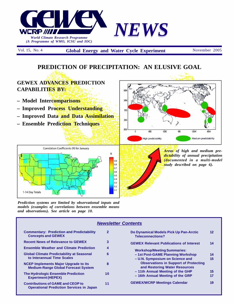
Areas of high and medium pre-dictability of annual precipitation(documented in a multi-modelstudy described on page 6).
Prediction systems are limited by observational inputs andmodels (examples of correlations between ensemble meansand observations). See article on page 10.
Newsletter Contents
Commentary: Prediction and Predictability 2Concepts and GEWEX
Recent News of Relevance to GEWEX 3
Ensemble Weather and Climate Prediction 4
Global Climate Predictability at Seasonal 6to Interannual Time Scales
NCEP Implements Major Upgrade to its 8Medium-Range Global Forecast System
The Hydrologic Ensemble Prediction 10Experiment (HEPEX)
Contributions of GAME and CEOP to 11Operational Prediction Services in Japan
Do Dynamical Models Pick Up Pan-Arctic 12Teleconnections?
GEWEX Relevant Publications of Interest 14
Workshop/Meeting Summaries:– 1st Post-GAME Planning Workshop 14– U.N. Symposium on Science and 15
Observations in Support of Protectingand Restoring Water Resources
– 11th Annual Meeting of the GHP 15– 16th Annual Meeting of the GRP 17
GEWEX/WCRP Meetings Calendar 19
GEWEX ADVANCES PREDICTIONCAPABILITIES BY:
– Model Intercomparisons– Improved Process Understanding– Improved Data and Data Assimilation– Ensemble Prediction Techniques

November 20052
COMMENTARY
PREDICTION AND PREDICTABILITYCONCEPTS AND GEWEX
Soroosh Sorooshian, ChairmanGEWEX Scientific Steering Group
Discussions about various interpretations of pre-diction and predictability concepts have been going onfor quite some time but in the past few years havebecome livelier thanks to the recently announced WCRPstrategy, the Coordinated Observation and Predic-tion of the Earth System (COPES), which has madethe topic of predictability and climate prediction itscentral focus for the 2005–2115 period. A number ofdefinitions have been given for these two concepts.A 2002 United States National Research Councilwater cycle workshop defined hydrologic predictabil-ity as a measure of “our ability to observe andcharacterize hydrologic systems and it is boundedby the inherent limits-to-prediction of thesystem...[which] are intimately tied to the observabilityof the system and the way in which variabilitypropagates through both the components of thewater cycle and across its scales.” The term "predic-tion" on the other hand is often used to describe thefuture state of the climate as it relates to the averageconditions and its range of variability and Earth-surface states, such as precipitation, temperature,humidity, and winds.
GEWEX has separated predictability and pre-diction in the articulation of its objectives. In short,predictability is more theoretical, aiming to pushthe limits of prediction accuracy towards “perfec-tion,” while prediction represents present ability toproduce reliable and useful predictions. Models arethe main engine in both cases. GEWEX contributesto model improvements through activities led bythe three GEWEX panels and the Coordinated En-hanced Observing Period and International SatelliteLand-Surface Climatology Project.
GEWEX focuses on those aspects in whichit has expertise and relies on other programs forthe areas in which more can be accomplishedcollaboratively. GEWEX has been emphasizing theutilization of higher resolution observations and im-proving the representation of land-surface processesin models. Our strong working relationship with theProgramme on Climate Variability and Predictibility(CLIVAR) in a number of areas includes our relianceon them for global scale predictions where oceansplay a dominant role. We look forward to workingclosely with the new WCRP Modelling Panel that hasbeen established under the umbrella of COPES.
While its contributions to the more theoreticalaspects of predictability will be continued, GEWEXhas an even more critical role in the current state ofthe art of climate prediction for use in an increasingrange of practical applications and of direct relevanceand benefit to society. For this reason GEWEXpromotes and works towards an end-to-end predic-tion system. For example, we now can reasonablypredict the onset of El Niño, months (or a season)in advance and with these events have some strongstatistical evidence that the Southwestern United Statesmay experience wetter than average winters. Thisknowledge alone is not sufficient to help water re-sources and reservoir managers to plan and takeoperational actions to benefit their system operations.An end-to-end approach requires that longer termpredictions be linked to short- term event forecastsand that the uncertainties of these forecasts be speci-fied. We also need to monitor forecast accuracy asa measure of our progress.
In this arena, the challenges are immense and willrequire close collaboration with other projects and pro-grams. Given the role of uncertainty in observations andprediction systems, it is not surprising that new ap-proaches to prediction such as ensemble techniques arebecoming popular since these methods can show therange and variability in forecast outcomes for a particularinitial condition. Our promotion and cooperation with thegrass roots Hydrologic Ensemble Prediction Experiment(HEPEX) effort addresses this issue. In addition, wehave initiated dialogue with a number of internationalhydrology programs such as the United Nations Environ-mental, Scientific and Cultural Organization's (UNESCO)Water and Development Information for Arid Lands–AGlobal Network and the International Association ofHydrological Sciences Project for Ungauged Basins (see mycommentary in the May 2005 issue of GEWEX NEWS).
The user community is the ultimate judge of ourability to provide useful predictions and relevant informa-tion. Hence, climate prediction evaluation tools andhydrologic verification tools are very important. Theprocedures shown at http://hydis6.hwr.arizona.edu/ForecastEvaluationTool are a good example of theformer, but the latter has completely been ignored untilrecently. Hydrologic verification lags far behind verifica-tion procedures used for weather forecasts such as skillscores. We rely on our Water Resources ApplicationPanel (WRAP) to take the lead in this area. To encour-age this new approach, I plan to propose at the upcomingGEWEX SSG that we change the name of WRAP tothe Hydrologic Applications Project (HAP) to morerealistically reflect GEWEX contributions to improvedhyroclimate predictions.

3November 2005
RECENT NEWS OF RELEVANCE TO GEWEX
GEWEX WELCOMES THENEW DIRECTOR OF WCRP
Beginning January 2006, Prof. Ann Henderson-Sellers will be the new Director of the Joint PlanningStaff of the World Climate Research Programme.
Prof. Henderson-Sellers, nowHead of the Institute forNuclear Geophysiology underthe Australian Nuclear Sci-ence Technology Organization,has had a long history withGEWEX as the lead investi-gator for the Project forIntercomparison of Land-sur-face Parameterization Schemes(PILPS) and the more recentIsotopes in PILPS (iPILPS).
A mathematician, with a Ph.D. and D.Sc. inatmospheric science, Prof. Henderson-Sellers is anISI “most highly cited” author of 452 publications,including 13 books. She is an elected Fellow of theAmerican Geophysical Union and the AmericanMeteorological Society and has served on Australia’sScience and Technology and Greenhouse ScienceAdvisory Councils, and various international andnational committees in climate, environmental policyand Earth sciences. Prof. Henderson-Sellers isalso a company director and Fellow of Australia’sInstitute of Company Directors and Academy ofTechnological Sciences and Engineering. She wasawarded the Centenary Medal of Australia for Ser-vice to Australian Society in Meteorology in 2003.
Buenos Aires was the site of a Latin AmericaCapacity Building workshop on “Earth observationsin the service of water management” on October26 to 28, 2006. The Workshop, which was orga-nized by the Comision Nacional de ActivadadesEspaciales (CONAE) and the Integrated Global WaterCycle Observations (IGWCO) theme/GEWEX, high-lighted applications of Earth observations in thewater management sector. Specialists from NorthAmerica, Japan and Europe in data assimilation,snow observations, remote sensing for hydrology,water quality and applications participated in theworkshop and presented overviews of the observa-tion and analysis capabilities in these different areas.Specialists from more than 12 Latin American coun-tries contributed to the discussions and presentedresearch results and descriptions of their observa-tional programs and needs for Earth Observations.
A meeting in October was held at the BritishNational Space Centre with Natural EnvironmentResearch Council (NERC)-funded researchers toexplore possible links between United Kingdomexperts and GEWEX, and the Integrated GlobalWater Cycle Observations (IGWCO) theme. Anumber of recommendations for collaborations inareas such as soil moisture, observations to sup-port flood forecasting, capacity building and UKEarth observation activities such as the Flow Re-gimes from International Experimental and NetworkData (FRIEND) will be addressed through IGWCOand GEWEX. These activities are expected to supportthe enhancement of GEWEX activities in Europe.
GEWEX/IGWCO MEETING IN UK
CAPACITY BUILDING WORKSHOP INLATIN AMERICA
CONTINENTAL-SCALE EXPERIMENTSSTRENGTHEN THEIR PROJECT
IMPLEMENTATION CAPABILITIES
Dr. Marcus Reckermann has joined the BalticSea Experiment Secretariat as a full-time staff mem-ber. He is a Biological Oceanographer and his primaryfield of research is the microbial food web dynam-ics in the sea. Dr. John Gibson, currently with theAustralian Nuclear Science and Technology Organi-zation on secondment from Environment Canada’sNational Water Research Institute, has joined theMurray Darling Basin Project. He has a backgroundin Earth Sciences and Mathematics with specialinterests in stable isotope hydrology.
NASA NEWS UPDATE
The National Aeronautics and Space Adminis-tration (NASA) Energy and Water Cycle Study(NEWS) held its kickoff meeting in New York onSeptember 7 to 9, 2005 with representatives from25 newly approved NEWS projects in attendance.Based on the science results and project planspresented at the meeting the NEWS implementa-tion plan is being modified for release in anopen forum through the NEWS website at http://wec.gsfc.nasa.gov/. The GEWEX community isinvited to comment on this plan.

November 20054
The use of ensemble forecasting techniqueshas grown enormously in the last few decades.Pioneers such as Ed Lorenz, Ed Epstein and PhilThompson introduced ideas in the 1960s and 1970sthat took root in the 1980s in the area of monthlyforecasting (Lewis, 2005). In the 1990s ensembleprediction techniques were used in operational me-dium-range and seasonal-interannual forecasting. Inthis decade both short-range and climate-changeensemble forecasts became possible. This articleaddresses three questions: (1) What is the scien-tific basis for ensemble prediction? (2) What is thevalue of ensemble forecasting? (3) What are theimportant research areas for ensemble prediction,especially with regard to GEWEX science?
Forecasts of weather and climate are inherentlyuncertain and forecasts with error bars are morevaluable than forecasts without them. Although er-ror bars can be estimated from a set of pastforecasts, predicting uncertainty using ensembleforecast techniques is more reliable. The reasonfor making this assertion is that the climate systemis non-linear so that the evolution of initial uncer-tainties depends on the flow; sometimes (and insome places) the flow will be stable and smallinitial perturbations will grow minimally, while onother occasions (and places) the flow will be un-stable and initial perturbations will grow rapidly.This effect of non-linearity can be illustrated usingthe prototypical Lorenz model (1963). See thefigure on this page. Consequently, ensemble pre-diction systems are practical tools to forecast theflow-dependent predictability of weather and cli-mate. Furthermore, for cases where we cannotestimate error bars from a set of past forecasts,such as in predicting climate change, ensembleprediction techniques are essentially our only chanceof estimating forecast uncertainty.
Going from theory to practice is a big stepbecause the underlying uncertainties in making weatherand climate forecasts are not fully understood.Many people break the forecast problem downinto initial condition uncertainties, model uncertain-ties and other uncertainties (such as emissions).This is not as meaningful a delineation as it mayappear. First, initial conditions are uncertain be-
ENSEMBLE WEATHER ANDCLIMATE PREDICTION
T. N. PalmerEuropean Centre for Medium-Range
Weather Forecasts, Reading, UK
cause the measuring instruments are not perfectlyaccurate and do not cover the Earth in its entirety.However, initial conditions are also uncertain be-cause the observations, typically point or pixel, areinfluenced by circulations which the assimilatingmodel is incapable of simulating properly due totruncation (i.e, model) errors. Also, initial condi-tions are uncertain because assumptions underlyingthe data assimilation procedures (e.g., gaussianityof error statistics) are uncertain.
In practice, if a researcher deals with only onesource of uncertainty, such as developing an en-semble data assimilation system in which randomuncorrelated errors are added to the observations,the corresponding forecast ensemble will beunderdispersive, and the forecast verification willlie outside the cloud of ensemble members. Moredispersive ensembles can be produced by inflatingthe random observation errors. However, this wouldbe problematic because one would be compensat-ing for an under-representation of one source oferror by over-representing another source of error.Operational forecast centres such as the EuropeanCentre for Medium-Range Weather Forecasts(ECMWF) and the National Oceanic and Atmo-spheric Administration's National Centers forEnvironment Prediction (NCEP) have taken a dif-ferent approach to representing initial uncertaintyby projecting initial perturbations onto patterns ofinstability of the atmosphere, as determined bytechniques known as singular vectors and breedingvectors (Kalnay, 2003).
The scientific basis for ensemble forecasting illustrated bythe prototypical Lorenz (1963) model for low order chaos,showing that in a nonlinear system, predictability is flowdependent. Top left: a forecast with high predictability,top right: forecast with moderate predictability, bottom:forecast with low predictability.

5November 2005
The representation of model uncertainty is adeveloping subject. Currently used methods in-clude multi-model ensembles; perturbed-parameterensembles; and stochastic physics. Each methodis viable but has its own different strengths andweaknesses (Palmer et al., 2005).
The value of ensemble prediction lies in itsusefulness for decision makers who can be givenforecasts in which the flow-dependent uncertaintiesare estimated as accurately as possible. Decisionmakers in weather or climate sensitive areas ofactivity want to know: what is the risk that tomor-row will be very windy, that the next season willbe very wet, or that the Earth will warm up suffi-ciently to melt the Greenland ice cap? A probabilityfor each event can be estimated from an appropri-ate ensemble forecast. Providing validation dataexists (less so for predictions of climate-change),techniques to estimate the performance of suchprobability forecasts can be applied to a set ofensemble forecasts (Jolliffe and Stephenson, 2003).
Ultimately the usefulness of ensemble forecastson weather and climate timescales lies in estimatesof value for decision makers (Palmer, 2005). Throughinstitutes such as the London School of Econom-ics and the Oxford Business School, ECMWF isassessing the economic value of ensemble fore-casts in weather and climate-sensitive markets suchas energy production (Roulston et al., 2003; Taylorand Buizza, 2003).
Three GEWEX-specific activities which link withensemble-prediction research are given below.
1. Hydrology. Hydrology is an application areawithin the GEWEX Hydrometeorology Panelwhere ensemble forecast techniques are po-tentially very valuable. The methodologyrequires that the applications model is runmany times, being forced by each indi-vidual member of the weather or climateensemble. In the case of hydrology applica-tions, the result can be a forecast probabilityof river discharge based on catchment-ba-sin precipitation forecasts. See related articleon the Hydrologic Ensemble Prediction Ex-periment (HEPEX) on page 10.
2. Representation of model uncertainty. Meth-ods to represent model uncertainty inensemble prediction systems can be devel-oped using cloud-resolving models as truth.For example, by coarse-graining a cloud-resolving model over a General CirculationModel (GCM) grid box, one can compare
a GCM-parameterized sub-grid tendency withthe “true” sub-grid tendency (Shutts andPalmer, 2005). The work of the GEWEXCloud System Study (GCSS) is particularlyrelevant in this respect.
3. Stochastic land-surface models. Buildingstochasticity into Earth-System models isvery relevant in the drive to have a fullrepresentation of model uncertainty in en-semble systems. There is a need to developstochastic land models for weather and cli-mate prediction and some early ideas inthese areas have been formulated (R. E.Dickinson, personal discussion).
In the 20th century, the study of predictabilitywas considered a rather idealized, ivory-tower pur-suit, compared with the more practical process ofprediction. However, in the 21st century, predictingpredictability, on all timescales from hours to cen-turies, is just as practical and important as predictingrainfall and temperature on these timescales. Thistransformation of the notion of predictability, fromthe ivory tower to the operational forecast centre,has arisen from the development of ensemble pre-diction systems. However, the development is notcomplete, and there is much to be done to improvethe representation of uncertainty in weather andclimate prediction.
References
Jolliffe, I. T., and D. B. Stephenson, 2003. Forecast Verifica-tion, Wiley 240 pp.
Kalnay, E., 2003. Atmospheric Modelling, Data Assimilationand Predictability, Cambridge University Press, 341 pp.
Lewis, J. M., 2005. Roots of ensemble forecasting, Mon WeaRev., 133, 1865–1885.
Lorenz, E. N., 1963. Deterministic non-periodic flow, J. Atmos.Sci., 42, 433–71.
Palmer, T. N., 2005. Progress towards reliable and useful seasonaland interannual climate predictions, WMO Bulletin, 53, 325–332.
Palmer, T. N., G. J. Shutts, R. Hagedorn, F. J. Doblas-Reyes, T.Jung, and M. Leutbecher, 2005. Representing Model Uncertaintyin Weather and Climate, Annu. Rev. Planet Sci., 33, 163–193.
Roulston, M. S., D. T. Kaplan, J. Hardenberg, and L. A. Smith,2003. Using medium-range weather forecasts to improve the valueof wind energy production, Renewable Energy, 28, 585–602.
Taylor, J., and R. Buizza, 2003. Using ensemble weather predic-tion in energy demand forecasting. Intern. J. Forecast., 19, 57-70.
Shutts, G. J., and T. N. Palmer, 2005. Statistical fluctuations inconvective forcing computed from a cloud-resolving model andtheir relevance to the parametrisation problem, J. Clim. submitted.

November 20056
Because of non-linear processes in the climatesystem, deterministic projections of climate variabilityand change are potentially subject to uncertaintiesarising from sensitivity to initial conditions or to pa-rameter settings. Such uncertainties can be partiallyquantified from ensembles of runs from the samemodel or from ensembles of integrations from differentclimate models. To make reliable forecasts of weatherand climate in the presence of both initial conditionsand model uncertainty, it is now common to repeat theprediction many times from different perturbed initialstates. This so called multi-initial condition ensemblehas been useful in separating interannual climate vari-ability into a chaotic component due to sensitivity toinitial conditions, and a potentially predictable compo-nent based on the ensemble average (Goddard et al.,2003, Marengo et al., 2003).
Seasonal to interannual and longer climate vari-ability has two components: (1) an externally forcedcomponent, which is the response to slowly varyingexternal boundary forcing [sea-surface temperature(SST), sea ice, albedo, and snow coverage] andradiative forcing (greenhouse gases and aerosol con-centration); and (2) an internally forced component,which is the atmospheric variability induced by in-ternal dynamics and the weather noise or by strongland-surface feedbacks due to land surface pro-cesses (Guo et al., 2005).
The externally forced component is potentiallypredictable at long range assuming that the forcingsthemselves are potentially predictable. Predictability ofclimate at seasonal-to-interannual time scales at bothglobal and regional scales must include an analysis ofsources of predictability (boundary conditions versusinitial conditions, as well as SST versus land surfaceboundary conditions), the El Niño/Southern Oscillation(ENSO) induced-predictability, as well as the ENSOinduced teleconnections, and the influence of otherocean basins, such as the Atlantic and Indian Oceans.The land-surface potentially provides additional sourcesof extended predictability for climate. Much of the skillin predicting departures from normal seasonal totals oraverages, often associated with atmospheric circulationpatterns has its origin in the slowly changing conditionsat the Earth’s surface that can influence climate.
Simulations using specified SST have an extensivehistory, and a comprehensive review of relevant workcan be found in Shukla et al. (2000) and Goddard etal. (2003), including the Atmospheric ModelIntercomparison Project (AMIP) climate simulations.Land surface characteristics and processes also serveas slowly varying boundary conditions on climate simu-lations. Realistic representation of land-atmosphereinteractions is essential to a realistic simulation andprediction of continental-scale climate and hydrology.For example, the interannual changes in snow cover-age in the Himalayas plays a role in the onset of theIndian monsoon, while internal oscillations can ac-count for a large part of the simulated monsoonvariability. Both in the real world and in the modelingsystems, the “memory” associated with continentalmoisture and the ability to forecast land-surface mois-ture state is limited. A recent paper by Guo et al.(2005) on the Global Land-Atmosphere Coupling Ex-periment (GLACE) shows both a wide variation in thestrength of land-atmosphere coupling and the ability ofsoil moisture to affect precipitation. This coupling isexamined in two stages: the ability of the soil moistureto affect evaporation and the ability of evaporation toaffect precipitation.
This article reviews issues related to seasonal tointerannual climate prediction and predictability duringthe summer rainy season at a global scale. We referto the experiences in seasonal climate predictability attwo of the World Meteorological Organization WorldData Centres: the Center for Weather Forecasts andClimate Studies (CPTEC) in Brazil and the Interna-tional Research Institute (IRI) in the United States.The dynamical climate predictions at IRI are currentlymade with six different atmospheric general circulationmodels. CPTEC runs the CPTEC/Center for Ocean-Land-Atmosphere Studies (COLA) Atmospheric GeneralCirculation Model (AGCM) at T62 (Marengo et al.,2003). Each month, these models are run 10 timesforming an ensemble (nine members at CPTEC), withone or two possible scenarios for the global SST, oneto three seasons (3 to 9 months) into the future. Ineach set of ensemble runs for a given SST scenario,the only difference between each run is the initialatmospheric state (the current weather) at the begin-ning of the run.
We examine the statistical patterns of rainfall fieldsfrom seven models for the 1950–2000 period andassess the skill of the models for summertime at globalscale, using the anomaly correlation score. Other skillscores such as Relative Operation Characteristics (ROC)and Ranked Probability Skill Score (RPSS) have beenalso explored, and since they show similar informationwe have chosen the anomaly correlation for the pre-dictability analyses. One of the regions with the highestpredictability is Northeast Brazil, while the central and
GLOBAL CLIMATE PREDICTABILITYAT SEASONAL TO INTERANNUAL
TIME SCALES
José Marengo, Lincoln M. Alves, andHelio Camargo
CPTEC/INPE, São Paulo, Brazil

7November 2005
Seasonal cycle (top)and interannual vari-ability of rainfall inNortheast Brazil (leftside) and Southwest Eu-rope (right side). Thedashed lines representthe observations (fromCRU) and the thickblack lines represent themean of the members.The lighter lines repre-sent each one of the in-dividual members of theensemble.
and interannual variations of rainfall remains problem-atic. Some of this lack of skill in simulating rainfall inthese regions arises from the strong effects on internalatmospheric variability, possibly due to land-surfacefeedback mechanisms or the representation of sub gridscale processes, as discussed by Koster et al. (2000).In tropical regions much of the predictable atmosphericvariability on interannual time scales is driven by SSTanomalies, with the most important source of variabil-ity being El Niño. Other factors beyond the externalforcing arising from SST anomalies may be importantin other year-to-year climate variability, suggesting otherlimitations on climate predictability in these regions.
References
Goddard, L., A. G. Barnston, and S. J. Mason, 2003. Evalu-ation of the IRI’s “Net Assesment” seasonal climate forecasts:1997–2001, Bull. Amer. Meteor. Soc., 84, 1761–1781.
Guo, A. Z., P. Dirmeyer, R. Koster, G. Bonan, P. Chan, P.Cox, et al., 2005. GLACE: The Global Land-AtmosphereCoupling Experiment Analysis (Submitted, J. Hydromet.).
Koster, R., M. J. Suarez, and M. Heiser, 2000. Varianceand predictability of precipitation at seasonal-to-interannualtimescales. J. Hydromet, 1, 26–46.
Marengo, J. A., I. F. A. Cavalcanti, P. Satyamurty, C. A.Nobre, J. P. Bonatti, et al., 2003. Ensemble simulation ofregional rainfall features in the CPTEC/COLA atmosphericGCM. Skill and Predictability assessment and applications toclimate predictions. Climate Dynamics, 21, 459–475.
Shukla, J., D. A. Paolino, D. M. Straus, D. De Witt, M.Fennessy, J. L. Kinter III, L. Marx, and R. Mo, 2000.Dynamical seasonal prediction with the COLA atmosphericmodel. Q. J. Roy. Met. Soc., v. 126, p. 2265–2291.
southern Europe regions have low predictability (Marengoet al., 2003). The figure on the right side of page 1shows the observed and simulated (CPTEC/COLAAGCM) annual cycle of rainfall for Northeast Braziland Southwest Europe. Areas in red indicate higherpredictability; areas in green indicate medium predict-ability, and lower predictability elsewhere. Highpredictability is defined in regions where anomaly cor-relation is larger than 0.6, medium predictability isdefined for correlation values between 0.3–0.5, andlower predictability is defined for correlation valuesbelow 0.3. In Northeast Brazil the seasonal cycle iswell reproduced even though the model systematicallyoverestimates precipitation, while in Southwest Europethe seasonal cycle is not well simulated.
In Northeast Brazil the interannual variability isvery well simulated, with the dry ENSO years in1983, 1987, 1990–92 and 1998 accurately producedvery low scatter among members. On the other hand,the interannual variability in Southwest Europe is notwell simulated by the model and the scatter amongmembers is quite large.
The figure below suggests indicators of regionswith different levels of skill for seasonal climate pre-dictions from seven models for the summer season.Regions were defined based on the values of thecorrelations. During the summer, tropical regions andsome subtropical regions near the oceans have highand medium predictability, while low predictability forrainfall is found over the continental regions in bothhemispheres, including the monsoon regions.
In summary, the skill scores from seven AGCMsindicate that in some regions, simulation of seasonal

November 20058
NCEP IMPLEMENTS MAJOR UPGRADETO ITS MEDIUM-RANGE GLOBALFORECAST SYSTEM, INCLUDING
LAND-SURFACE COMPONENT
Ken Mitchell, Helin Wei, Sarah Lu,George Gayno, and Jesse Meng
NCEP Environmental Modeling CenterCamp Springs, Maryland, USA
Prediction systems often rely on physical pro-cess research to realize the model improvementsneeded to improve forecast skill. This article detailsrecent improvements in the National Oceanic andAtmospheric Administration (NOAA) National Cen-ters for Environmental Prediction (NCEP) globalmodel that have been derived in part from GEWEXresearch.
On 31 May and 14 June 2005, NCEP exten-sively upgraded the land-surface component of itsGlobal Forecast System (GFS), including its GlobalData Assimilation System (GDAS). Other substan-tial GFS upgrades were also implemented on May31, including increased horizontal resolution fromabout 50 km (T254) to about 35 km (T382), a newsea-ice model, enhanced mountain blocking in thegravity-wave drag, modified vertical diffusion, andupgrades to the objective analysis in the GDAS(more satellite radiance data, enhanced quality con-trol, and improved emissivity calculations over snowand sea ice). All the upgrades and names of themany contributors are given in the NCEP technicalbulletin at: http://www.emc.ncep.noaa.gov/gc_wmb/Documentation/TPBoct05/T382.TPB.FINAL.htm.
This article describes the land surface model(LSM) upgrade, wherein the NCEP Noah LSM(Version 2.7.1) replaced the Oregon State Univer-sity (OSU) LSM, which had been operational inthe GFS since the mid-1990s. The Noah LSMembodies about 10 years of upgrades (see Chen etal., 1996; Koren et al., 1999; Ek et al., 2003) to itsancestor, the OSU LSM. These upgrades weredeveloped and tested by the Environmental Model-ing Center (EMC) Land Team, assisted by manycollaborators, including the National Weather Ser-vice Office of Hydrological Development, NationalEnvironmental Satellite Data and Information Ser-vice Office of Research and Applications, NationalCenter for Atmospheric Research, National Aero-nautics and Space Administration, OSU, and universityprincipal investigators of the GEWEX Americas
Prediction Project, which is sponsored by the NOAAOffice of Global Programs (OGP).
The Noah LSM upgrade includes an increasefrom two (10, 190 cm thick) to four soil layers (10,30, 60, 100 cm thick), addition of frozen soil phys-ics, new formulations for infiltration and runoff (givingmore runoff for unsaturated soils), revised physicsof the snowpack and its influence on surface heatfluxes and albedo, tuning and adding canopy resis-tance parameters, allowing spatially varying rootdepth, revised treatment of ground heat flux andsoil thermal conductivity, reformulation for depen-dence of direct surface evaporation on first layersoil moisture, and improved seasonality of greenvegetation cover. The frozen soil physics includessoil heat sinks/sources from freezing/thawing andinfluences vertical transport of soil moisture, soilthermal conductivity and heat capacity, and surfaceinfiltration. The prognostic states of snowpack depthand liquid soil moisture were added to the alreadypresent prognostic states of snowpack water-equivalent(SWE), total soil moisture (liquid plus frozen), soiltemperature, canopy water, and skin temperature.SWE divided by the snowpack depth gives the snow-pack density. Total soil moisture minus liquid soilmoisture gives the frozen soil moisture.
To provide initial values of soil moisture/tem-perature, the Noah LSM land states cyclecontinuously in the coupled atmosphere/land globalmodel of the GDAS. These land states respond tothe global model’s predicted land-surface forcing(precipitation, surface radiation, near-surface air tem-perature, humidity, and wind speed). Since theland component of the GDAS is forced by modelprediction rather than observed precipitation, weavoid undue drift by nudging soil moisture towardsa monthly global climatology (in GDAS only, notin forecast).
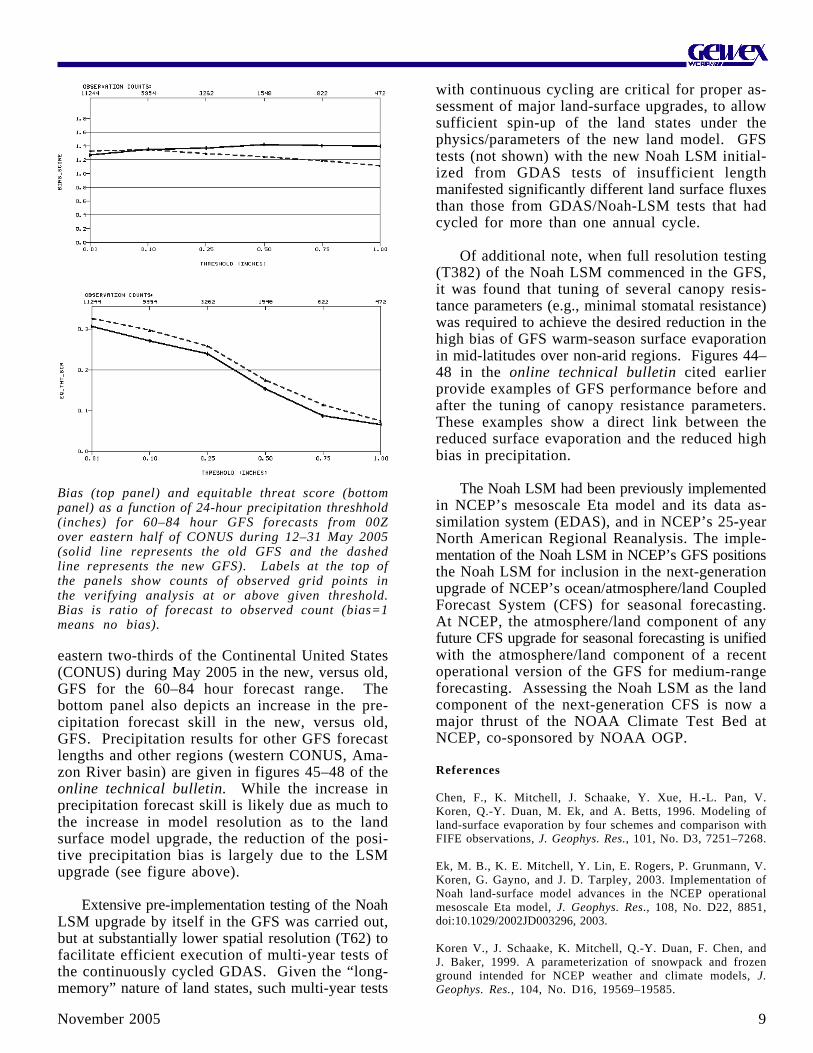
For some years, the GFS had manifested twoprominent biases in land-surface processes: 1) anearly depletion of snowpack; and 2) a high bias inboth surface evaporation and precipitation in thewarm season in non-arid mid-latitude regions. TheNoah LSM upgrade greatly reduces the early depletionof snowpack and the warm-season high bias in bothsurface evaporation and precipitation in mid-lati-tudes. (In the online technical bulletin cited earlier,figures 1 and 2 show the significant reduction ofearly snowpack depletion and figure 44 illustratesthe reduced warm-season surface evaporation.) Thetop panel of the figure on the next page showsthe reduced high bias in precipitation over the
9November 2005
eastern two-thirds of the Continental United States(CONUS) during May 2005 in the new, versus old,GFS for the 60–84 hour forecast range. Thebottom panel also depicts an increase in the pre-cipitation forecast skill in the new, versus old,GFS. Precipitation results for other GFS forecastlengths and other regions (western CONUS, Ama-zon River basin) are given in figures 45–48 of theonline technical bulletin. While the increase inprecipitation forecast skill is likely due as much tothe increase in model resolution as to the landsurface model upgrade, the reduction of the posi-tive precipitation bias is largely due to the LSMupgrade (see figure above).
Extensive pre-implementation testing of the NoahLSM upgrade by itself in the GFS was carried out,but at substantially lower spatial resolution (T62) tofacilitate efficient execution of multi-year tests ofthe continuously cycled GDAS. Given the “long-memory” nature of land states, such multi-year tests
with continuous cycling are critical for proper as-sessment of major land-surface upgrades, to allowsufficient spin-up of the land states under thephysics/parameters of the new land model. GFStests (not shown) with the new Noah LSM initial-ized from GDAS tests of insufficient lengthmanifested significantly different land surface fluxesthan those from GDAS/Noah-LSM tests that hadcycled for more than one annual cycle.
Of additional note, when full resolution testing(T382) of the Noah LSM commenced in the GFS,it was found that tuning of several canopy resis-tance parameters (e.g., minimal stomatal resistance)was required to achieve the desired reduction in thehigh bias of GFS warm-season surface evaporationin mid-latitudes over non-arid regions. Figures 44–48 in the online technical bulletin cited earlierprovide examples of GFS performance before andafter the tuning of canopy resistance parameters.These examples show a direct link between thereduced surface evaporation and the reduced highbias in precipitation.
The Noah LSM had been previously implementedin NCEP’s mesoscale Eta model and its data as-similation system (EDAS), and in NCEP’s 25-yearNorth American Regional Reanalysis. The imple-mentation of the Noah LSM in NCEP’s GFS positionsthe Noah LSM for inclusion in the next-generationupgrade of NCEP’s ocean/atmosphere/land CoupledForecast System (CFS) for seasonal forecasting.At NCEP, the atmosphere/land component of anyfuture CFS upgrade for seasonal forecasting is unifiedwith the atmosphere/land component of a recentoperational version of the GFS for medium-rangeforecasting. Assessing the Noah LSM as the landcomponent of the next-generation CFS is now amajor thrust of the NOAA Climate Test Bed atNCEP, co-sponsored by NOAA OGP.
References
Chen, F., K. Mitchell, J. Schaake, Y. Xue, H.-L. Pan, V.Koren, Q.-Y. Duan, M. Ek, and A. Betts, 1996. Modeling ofland-surface evaporation by four schemes and comparison withFIFE observations, J. Geophys. Res., 101, No. D3, 7251–7268.
Ek, M. B., K. E. Mitchell, Y. Lin, E. Rogers, P. Grunmann, V.Koren, G. Gayno, and J. D. Tarpley, 2003. Implementation ofNoah land-surface model advances in the NCEP operationalmesoscale Eta model, J. Geophys. Res., 108, No. D22, 8851,doi:10.1029/2002JD003296, 2003.
Koren V., J. Schaake, K. Mitchell, Q.-Y. Duan, F. Chen, andJ. Baker, 1999. A parameterization of snowpack and frozenground intended for NCEP weather and climate models, J.Geophys. Res., 104, No. D16, 19569–19585.
Bias (top panel) and equitable threat score (bottompanel) as a function of 24-hour precipitation threshhold(inches) for 60–84 hour GFS forecasts from 00Zover eastern half of CONUS during 12–31 May 2005(solid line represents the old GFS and the dashedline represents the new GFS). Labels at the top ofthe panels show counts of observed grid points inthe verifying analysis at or above given threshold.Bias is ratio of forecast to observed count (bias=1means no bias).

November 200510
THE HYDROLOGIC ENSEMBLEPREDICTION EXPERIMENT (HEPEX)John Schaake1, Kristie Franz2, Allen Brad-
ley3, and Roberto Buizza4
1NOAA/National Weather Service,2University of California, Irvine, 3University
of Iowa, 4European Centre for Medium-Range Weather Forecasts
Users of hydrologic predictions need reliable,quantitative forecast information, including estimatesof uncertainty, for lead times ranging from lessthan an hour during flash flooding events to morethan a year for long-term water management. TheHydrologic Ensemble Prediction EXperiment(HEPEX) )is an international effort that brings to-gether hydrological and meteorological communitiesto develop advanced probabilistic hydrologic fore-cast techniques that use new weather and climateensemble forecasts. HEPEX will demonstrate howto produce reliable hydrological ensemble predic-tions that can be used with confidence to makedecisions that have important consequences for theeconomy, environment, public health and safety.
The key science issue for HEPEX is reliablequantification of hydrologic forecast uncertainty. HEPEXplans to address the following key questions: (1)What are the adaptations required for meteorologicalensemble systems to be coupled with hydrologicalensemble systems? (2) How should the existing hy-drological ensemble prediction systems be modifiedto account for all sources of uncertainty within aforecast? and (3) What is the best way for the usercommunity to take advantage of ensemble forecasts?
HEPEX is a global project affiliated with GEWEXthat helps GEWEX meet its water resource applica-tions objectives. Also, it is an important GEWEXcontribution to the over-arching WCRP CoordinatedObservation and Prediction of the Earth System(COPES) initiative. HEPEX will rely on the Interna-tional Association of Hydrological Sciences (IAHS)Predictions for Ungauged Basins (PUB) initiative forcontributions of new science and data sets, andexpects PUB to participate in its test bed projects.A brief description of HEPEX was recently publishedin EOS (Franz et al., 2005).
Participation in HEPEX is open to anyone wish-ing to contribute to its objectives. HEPEX activitiesinclude test bed projects, development of supportingdata sets, development of components of a Commu-nity Hydrologic Prediction System (CHPS), andsponsorship of workshops and special sessions at
scientific meetings. HEPEX test bed projects will beused to develop CHPS components and to meet theHEPEX demonstration goal. CHPS is expected tohave an open systems architecture that will easilyaccommodate new forecast components and greatlyaccelerate infusion of new hydrologic science intohydrologic forecast operations. HEPEX invites poten-tial forecast users to participate in HEPEX activitiesand the “Users Forum,” which helps oversee activi-ties to assure user needs are being addressed.
HEPEX builds upon two international planningworkshops: the first was hosted by the EuropeanCenter for Medium-Range Weather Forecasts, March8–10, 2004, where the HEPEX science agenda wasestablished and the second one was held at theNational Center for Atmospheric Research, July19–21, 2005, where several test bed projects wereinitiated.
HEPEX will interact with GEWEX by demon-strating how to use improved climate forecast productsthat GEWEX will help to produce. This couldinclude developing a seamless approach to the appli-cation of weather and climate forecasts throughcollaboration with The Observing System Researchand Predictability Experiment (THORPEX) Interac-tive Grand Global Ensemble (TIGGE) Project. TIGGEis expected to provide an ensemble of 2-week fore-cast inputs that can be used for hydrologic ensembleprediction.
Biases in weather and climate forecasts must beremoved and the forecasts must be downscaled forhydrologic application. This requires an archive offorecasts and corresponding observations that can beused to estimate parameters of the hydrologic en-semble preprocessor. The archive of ensemble forecastsfrom the National Weather Service Global ForecastSystem for the period 1979 to the present is animportant initial global source of meteorological en-semble forecasts to study this issue. A measureof the potential importance of the ensemble precipi-tation forecasts is the correlation between the ensemblemean and the corresponding observation. The highcorrelation for 14-day total precipitation (see figureon the left side of page 1) for most of the UnitedStates, and the eastern/midwestern United States andthe mountainous west in particular, demonstrates theirpotential for improving hydrological predictions. Formore information see the HEPEX website at http://hydis8.eng.uci.edu/hepex.
Reference
Franz, K., N. Ajami, J. Schaake, and R. Buizza, 2005. Hydro-logic Ensemble Prediction Experiment Focuses on ReliableForecasts, Eos, Vol. 86, No. 25.

11November 2005
CONTRIBUTIONS OF GAME AND CEOPTO OPERATIONAL PREDICTION
SERVICES IN JAPAN
Nobuo Yamazaki1, Kiyotoshi Takahashi1,and Masayuki Hirai2
1Meteorological Research Institute,2Numerical Prediction Division, Japan
Meteorological Agency
The GEWEX Asian Monsoon Experiment (GAME)was implemented in 1996 to understand the role ofthe Asian monsoon in the global climate system andimprove long-range forecasting. The GAME reanaly-sis conducted by the Japan Meteorological Agency's(JMA) Meteorological Research Institute and Numeri-cal Prediction Division (NPD) uses four-dimensionaldata assimilation (4DDA) to integrate operational andexperimental observation data to produce a more com-prehensive data set from the atmosphere and landsurface hydrology. Phase I of GAME was success-fully completed in 2001, the same year the CoordinatedEnhanced Observing Period (CEOP) was launched.Under CEOP, collaboration with JMA's operationalactivity was extended. This article reviews the GAMEreanalysis and collaborative activities carried out byJMA under GAME and CEOP.
In the summer of 1998 GAME conducted inten-sive sonde observations at the same time as the SouthChina Sea Monsoon EXperiment (SCSMEX). All avail-able off-line data observed in GAME and SCSMEXwere analyzed using the operational JMA forecastmodel with T213 horizontal resolution (about 60 kmresolution) and 30 vertical layers. The PrognosticArakawa-Schubert convection scheme and 3D opti-
mal interpolation assimilation schemes were also usedin the model.
Two-dimensional precipitation and radiation fields,as well as fundamental atmospheric fields are pro-vided at 1.25 by 1.25 degrees and 2.5 by 2.5 degreesglobally. For the Asian and Pacific regions (30E-180W, 80N-30S), atmospheric fields were provided ata higher resolution (0.5 by 0.5 degree). GAME Re-analysis data are available at: gain-hub.mri-jma.go.jp/GAME_reanal.html for the 7-month period of 1 Aprilto 31 October 1998 in 6-hour intervals.
A comparison of the GAME reanalysis and theTropical Rainfall Measuring Mission (TRMM) precipi-tation is shown in the upper left figure on page 20.The left two, middle two and the right two groupsshow biases [root mean square error (RMS) in milli-meters calculated daily] and correlation coefficients(multiplied by 100) between daily time series fromeach of three reanalyses (JMA, European Centre forMedium-Range Weather Forecasts, US National Cen-ters for Environmental Prediction), analyzed precipitationand TRMM, respectively. Each value is averagedover 2.5 by 2.5 grids with TRMM Precipitation Radar(PR) estimates for a day. The Asian region is shownon the left-hand side and global coverage (0º–360,30ºS to 40ºN) is shown on the right. Evaluation ofthe RMS error and time correlation show that precipi-tation from the GAME reanalysis is very reliablewhen compared to other reanalyses and operationalanalysis. Since precipitation is related to atmosphericdivergence, good reproduction of precipitation implieshigh quality divergent fields.
Many process studies have used GAME reanaly-sis data. Research by Ueda et al. (2003) showed the
(a) 2-m surface temperature validation results for the CEOP Asia-Australia Monsoon Project (CAMP)/Inner Mongoliausing 120-hr forecast time (FT) initialized for 1 January 2003 shows better diurnal temperature ranges from the newexperimental Simple Biosphere (SiB) model than from the operational SiB when compared to observations. (b) Snowpackformation for BALTEX/Lindenberg shows the snowpack forming at 72 hrs FT. After that, the temperatures from the newSiB model are colder than the observations and the results of the operational SiB.
November 200512
DO DYNAMICAL MODELS PICK UPPAN-ARCTIC TELECONNECTIONS?
Stephen J. Déry1, Lifeng Luo2,Justin Sheffield2, and Eric F. Wood2
1University of Northern British Columbia,2Princeton University
Although our knowledge and understanding of thepan-Arctic climate system has improved in recentyears, the existence and degree of pan-Arctic climateconnectivity, and hence predictability, is not wellknown. Teleconnection patterns imply that the stateof the atmosphere, ocean, and land surface at remotelocations (from the mid-latitudes to the tropics) canimpact conditions at high northern latitudes; andconversely, the state of the pan-Arctic domain caninfluence regions further to the south. Theseteleconnections are characterized by strong statisticalrelationships between climates in different regions thatprovide useful information for seasonal predictions,the study of large-scale land-surface-atmosphere in-teractions, and understanding atmospheric moisture/energy transport pathways.
Snow constitutes one of the most prominent andtransient features of the pan-Arctic domain. Fluctua-tions in snow cover extent vary considerably in bothspace and time, especially during the transition sea-sons of spring and fall. Continental-scale snowanomalies substantially affect the surface radiationand water budgets, particularly during spring andearly summer that appear to impact remote locationsthrough large-scale teleconnections. There is a sub-stantial body of research that has investigated a numberof snow-related teleconnections including a relation-ship between Eurasian snow cover extent anomaliesand the Indian summer monsoon; the role of borealsummer/fall snow cover extent anomalies in Eurasiaand the Arctic Oscillation and the North AtlanticOscillation and to wintertime storminess over N.America; and potential intercontinental teleconnectionbetween simulated spring snow water equivalent (SWE)and soil moisture anomalies in Eurasia and meteoro-logical fields in N. America.
These studies provide evidence that Eurasian snowcover extent anomalies play a key role in pan-Arcticclimate connectivity. However, the degree to whichthe Eurasian snow anomalies affect the terrestrialwater budget in Canada remains unknown. Recentwork by the authors is designed to explore therelationship between measured Eurasian snow coverextent anomalies and observed Canadian SWE andriver discharge anomalies. Three independent datasets are used to investigate pan-Arctic climate con-nectivity: (1) monthly mean snow cover extent for
importance of pre-monsoonal latent heating in ad-dition to conventional sensible heating around theTibetan Plateau. Using an isotope circulation modelforced by the GAME reanalysis data, Yoshimura etal. (2003) reproduced observed precipitation iso-tope variations. They found that transport and mixingprocess are important for 1–10 day variability ofprecipitation isotopes. Yokoi and Satomura (2005)used the GAME reanalysis data and other observa-tional data and showed that the 10–20 day variationassociated in Thailand precipitation is similar to anequatorial Rossby wave and has distinctive verticalstructures. Yasunari and Miwa (2005) documentedthe large diurnal cycle of convection and circulationover the Tibetan Plateau that occasionally plays animportant role in the development of mesoscale cloudsystems in the Meiyu front over China.
In 2001, JMA began a joint Japanese Reanalysisproject (JRA-25) with the Central Research Instituteof Electronic Power Industry for the period of 1979to 2004. JRA-25 uses 3DVAR data assimilation withan improved forecast model compared to the GAMEreanalysis. JRA-25 includes GAME Intensive Obser-vation Period sonde data and is considered to be anupdated version of the GAME reanalysis for 1998.
JMA has supported CEOP through NPD which isproviding operational products to the CEOP dataarchive. Furthermore, the Climate Prediction Divisionprovides JRA-25 to this archive. NPD is using in situobservation data from the CEOP reference sites forglobal model validation, especially in the developmentof new land surface models.
Through these experiences, we have recognizedthe importance of model performance for accuratedata assimilation. As shown here, model validationwith observational data is an effective way to improvemodel performance. As CEOP provides useful inte-grated data sets for validation, cooperation with CEOPis one of the most important activities for modeldevelopment at JMA.
References
Ueda, H., et al., 2003. Seasonal contrasting features of heat andmoisture budgets between the eastern and western Tibetan Pla-teau during the GAME IOP. J. Climate, 16, 2309–2324.
Yasunari, T., and T. Miwa, 2005. Convective cloud systems overthe Tibetan Plateau and their impact on mesoscale disturbances inMeiyu/Baiu frontal zone. J. Meteorol. Soc. Japan (in revision).
Yokoi S., and T. Satomura, 2005. An Observational Study ofIntraseasonal Variations over Southeast Asia during the 1998 RainySeason. Mon. Weather Rev.: Vol. 133, No. 7, pp. 2091–2104.
Yoshimura K., et al., 2003. A quantitative analysis of short-termvariability with a Rayleigh-type isotope circulation model. J. Geophys.Res., 108, 4647, doi:10.1029/2003JD003477.

13November 2005
Eurasia covering the period 1973–2003 from the NationalOceanic and Atmospheric Administration (NOAA);(2) N. American monthly mean SWE (in millimeters)gridded data at a resolution of 0.3° from the Cana-dian Meteorological Centre for the period 1980–1997(Brown et al., 2003); and (3) daily streamflow recordsfrom the Water Survey of Canada’s HydrometricDatabase for 64 major rivers of northern Canada(Déry and Wood, 2005). The Eurasian snow coverextent anomalies are then correlated to the NorthAmerican SWE anomalies to river discharge anoma-lies in 64 basins of northern Canada. Time lags orleads (from 0-12 months) are imposed in the calcu-lations to determine possible causal relationships andonly correlation coefficients with p < 0.05 are con-sidered statistically significant. Déry et al. (2005)provide details on the data and methodology.
The figure on the top right side of page 20 showsthe correlation coefficient between Eurasian snowcover extent anomalies in August and annual maxi-mum SWE anomaly over Canada the following winterfor the period 1980–1997. There also exist (p < 0.05)positive (negative) correlations between spring andsummer Eurasian snow cover extent anomalies andnortheastern (northwestern) Canada maximum SWEanomalies the following winter. There is a decline inthe strength of the correlations when computed withthe October Eurasian snow cover extent anomalies.No significant correlations are observed in southernCanada or the United States.
The figure on this page presents the annual Eurasiansnow cover extent anomalies correlated to the annualstreamflow anomalies of 64 rivers of northern Canadafor which hydrometric data are readily available (Déryand Wood, 2005). The results suggest that riverdischarge into the Labrador Sea and Eastern HudsonBay is strongly influenced by the preceding yearEurasian snow cover extent anomalies. Nineteen riv-ers of northern Québec and Labrador, draining anarea > 0.6 × 10⁶ km2 and with a mean annual totaldischarge of 320 km3 yr-1 show statistically significantpositive correlations. These rivers exhibit a spa-tially coherent response to the Eurasian snow coverextent anomalies.
Simulations of the 20th century from eleven differ-ent dynamical climate model/configurations were obtainedfrom the Intergovernmental Panel on Climate Change4th assessment. The number of ensembles availablevaried across the models and ranged from 1 to 9 withthe ensemble mean of each available model used inthe following analysis. Correlations were computedbetween August Eurasian snow cover extent andfollowing winter maximum SWE, and the results areshown for four represented models (see figure at thebottom of page 20). As can be seen, the models
show statistically significant correlations over the studyregion, but the patterns are significantly different fromthe correlation patterns based on observations.
The above result has implications regarding cur-rent and future climate projections and predictionsbased on coupled climate models. The results in thefigure at the bottom of page 20 show consistencyacross three of the models in that they have statisti-cally significant correlations with SWE in themountainous regions of the Canadian west coast andin the western US, which is absent in the observationallybased correlations. This implies a teleconnection notsupported by observations. Seasonal prediction skillby dynamical models requires that teleconnectionsand connectivity patterns be well simulated and beconfirmed through observations. Ultimately, proce-dures for merging (skill-weighted) predictions fromstatistical models with those from dynamical modelsare needed to provide the most enhanced predictionproduct.
References
Brown, R. D., B. Brasnett, and D. Robinson, 2003. Gridded NorthAmerican monthly snow depth and snow water equivalent forGCM evaluation. Atmos.-Ocean, 41, 1–14.
Déry, S. J., and E. F. Wood, 2005. Decreasing river discharge innorthern Canada, Geophys. Res. Lett., 32, L10401, doi: 10.1029/2005GL022845.
Déry, S. J., J. Sheffield, and E. F. Wood, 2005. Connectivitybetween Eurasian snow cover extent and Canadian snow waterequivalent and river discharge. J. Geophys. Res., in press.
The correlation coefficient between the Eurasian annualsnow cover extent anomalies and the annual dischargeanomalies for 64 rivers of northern Canada (gray shading)the following year, 1973–2003. Positive (negative)correlations are denoted by upward (downward) triangles,with statistically significant correlations (p < 0.05) de-noted by larger symbols. Open triangles denote riversaffected by major dams, diversions, and/or reservoirs.The symbols are located at the coordinates of the mea-suring gauge of each river nearest the outlet to high-latitude oceans. Dashed lines denote five regional basinsof northern Canada (LS, Labrador Sea; EHB, EasternHudson Bay; WHB, Western Hudson Bay; ARO, ArcticOcean; BS, Bering Strait).

November 200514
GEWEX RELEVANT PUBLICATIONSOF INTEREST
Fundamental Challenge in Simulation andPrediction of Summer Monsoon Rainfall
Reference: B. Wang, Q. Ding, X. Fu, I.-S. Kang, K.Jin, J. Shukla, and F. Doblas-Reyes, 2005. Geophys.Res. Letters, Vol.. 32, L15711.Summary/Abstract: The scientific basis for two-tierclimate prediction lies in the predictability determinedby the ocean and land-surface conditions. The au-thors show that the state-of-the-art atmospheric generalcirculation models (AGCMs), when forced by ob-served sea-surface temperature (SST), are unable tosimulate properly Asian-Pacific summer monsoon rain-fall. All models yield positive SST-rainfall correlationsin the summer monsoon that are at odds with obser-vations. The observed lag correlations between SSTand rainfall suggest that treating a monsoon as a slavepossibly results in the models’ failure. They demon-strate that an AGCM, coupled with an ocean model,simulates realistic SST-rainfall relationships; however,the same AGCM fails when forced by the sameSSTs that are generated in its coupled run, suggestingthat the coupled ocean-atmosphere processes are crucialin the monsoon regions where atmospheric feedbackon SST is critical. The present finding calls forreshaping of current strategies for monsoon seasonalprediction.
Long-Range Predictability in the Tropics.Part I: Monthly Averages
Reference: T. Reichler and J. O. Roads, 2005.J Climate: Vol. 18, No. 5, pp. 619–633.
Summary/Abstract: The sensitivity to initial and bound-ary conditions of monthly mean tropical long-rangeforecasts (1–14 weeks) during the N. Hemispherewinter is studied with a numerical model. Five pre-dictability experiments with different combinations ofinitial conditions and prescribed ocean boundary con-ditions are conducted in order to investigate thetemporal and spatial characteristics of the perfectmodel forecast skill. It is shown that initial conditionsdominate a tropical forecast during the first 3 weeksand that they influence a forecast for at least 8weeks. The initial condition effect is strongest overthe E. Hemisphere and during years when the ElNiño–Southern Oscillation (ENSO) phenomenon isweak. The relatively long sensitivity to initial condi-tions is related to a complex combination of dynamicand thermodynamic effects, and to positive internalfeedbacks of large-scale convective anomalies. Atlead times of more than 3 weeks, boundary forcingis the main contributor to tropical predictability.
WORKSHOP/MEETING SUMMARIES
1ST POST-GAME PLANNING WORKSHOP28 August 2005
Kyoto, JapanJun Matsumoto
University of Tokyo, Japan
The First International Post-GEWEX Asian Mon-soon Experiment (GAME) Planning Workshop washeld at Kyoto International Community House withthe support of the Ministry of Education, Culture,Sports, Science and Technology of Japan, theHydrospheric Atmospheric Research Center, NagoyaUniversity, the Research Institute of Humanity andNature, and Kyoto University Active GeosphereInvestigation. Forty participants from ten countriesmet to discuss the objectives, key scientific ques-tions, expected achievements, international cooperationstrategies, regional structures and schedule for apost-GAME program.
The post-GAME program will aim to improvethe prediction of the Asian monsoon and its hydro-logical cycle, focusing on establishing a scientificbasis for predicting the hydroclimate monsoon sys-tem with a special emphasis on intraseasonal toseasonal time-scale, including developing predic-tion systems for droughts and flood conditions ofregional river basins and similar areas in Asia. Itwill target processes in the Asian summer andwinter monsoon. Its spatial coverage will includethe tropics from the maritime continent to Southand Southeast Asia, Tibet/Himalaya, East Asia, andNortheast Asia. More emphasis will be placed onthe air-land-ocean interactions, the role of aerosolson monsoons, monsoon predictability, and flood/drought predictions.
It is planned that this program will undertake anessential role in the WCRP research strategy—theCoordinated Observation and Prediction of the EarthSystem (COPES)—and will contribute to other re-lated international initiatives, such as the GlobalEarth Observation System of Systems (GEOSS),the Coordinated Enhanced Observing Period (CEOP),The Observing System Research and PredictabilityExperiment (THORPEX), the International Hydrol-ogy Programme (IHP)-Project for Ungauged Basins(PUB), the SysTem for Analysis, Research andTraining (START), and the Global Water SystemProject (GWSP). A special observation period maybe planned in conjunction with the InternationalPolar Year in 2008.

15November 2005
11TH ANNUAL MEETING OF THE GHP
26–29 September 2005Melbourne, Australia
John RoadsScripps ECPC, UCSDLa Jolla, California
The 11th meeting of the GEWEX Hydrometeo-rology Panel (GHP), chaired by John Roads, washosted by Alan Seed at the Bureau of MeteorologyResearch Center in Melbourne, Australia. The BMRCis the numerical weather prediction center associ-ated with the Murray Darling Basin (MDB) ContinentalScale Experiment (CSE). The objective for thisGHP meeting was to review the past year’s progressand refocus objectives to meet the GEWEX PhaseII objectives, which have been modified to reflectthe recent WCRP strategy for international researchand collaboration efforts—the Coordinated Obser-vation and Prediction of the Earth System (COPES).Future GHP activities are being increasingly focusedon developing a regional to global hydrometeoro-logical analysis and predictive capability anddeveloping applications of GEWEX science foroperational hydrology.
Two of the CSEs, the GEWEX Asian MonsoonExperiment (GAME) and Mackenzie GEWEX Study(MAGS) are ending this year. In addition, both theBaltic Sea Experiment (BALTEX) and the Large-scaleBiosphere Atmosphere Experiment in Amazonia (LBA)have now completed their Phase I activities.
A follow-on project for GAME is planned withthe objective to improve the prediction of the Asianmonsoon and its hydrological cycle (see the post-GAME workshop report on page 15). Wrap-upactivities for MAGS will include preparation of a dataDVD, a book on cold regions hydroclimate sciencebased on MAGS research and a monograph onapplications and knowledge transfer.
The BALTEX Phase II science plan has beenpublished and the implementation plan will be com-pleted this year. One of the major activities of LBAPhase II will be the Regional Atmospheric CarbonBudget in Amazonia (BARCA), which will addressthe basin-wide budgets of CO2, CH4 and water.
The GEWEX Americas Prediction Project (GAPP)plans to continue as part of the Coupled PredictionProject for the Americas (CPPA). Through GAPP,numerous operational model upgrades have improvedthe Environmental Modeling Center global forecast
U.N. SYMPOSIUM ONSCIENCE AND OBSERVATIONS INSUPPORT OF PROTECTING ANDRESTORING WATER RESOURCES
13–16 September 2005Graz, Austria
Rick LawfordInternational GEWEX Project Office
The United Nations Office for Outer SpaceAffairs (UNOOSA) and the European Space Agencyheld a symposium at the Austrian Academy ofSciences to explore the possible applications ofsatellite data for protecting and restoring waterresources around the world as part of a mission todevelop an “Earth Observation-enabled society.”Approximately half of the 75 participants camefrom countries in Africa, the Middle East andEastern Asia, thus ensuring that the Workshop hada good balance of viewpoints from both the devel-oped and the developing world.
Presentations reviewed the applications of re-mote sensing data for protecting and restoring waterresources in a number of regions including centralAmerica, the Caucasus mountains, the Lake Chaddrainage basin in Africa, northern Viet Nam andthe countries of Morocco and Uzbekistan. This ledto the identification of information and data neededfor efficient regional and national water resourcemanagement. In particular, near-term benefits couldresult from using forecast information on floods totake mitigating actions, such as draining reservoirsin advance of a flood event and using geologicalmapping techniques and satellite data to map ground-water potential.
Subsequent discussions dealt with the develop-ment of low cost methods and technologies inusing Earth observations, such as telecommunica-tions and mapping software to address waterchallenges in the developing world. As a serviceto the community, UNOOSA has established anexpert committee to assist groups in the develop-ing world develop proposals for new projects thatexploit Earth observations.
A discussion of water-related disasters, includingfloods and droughts, demonstrated the opportunitiesfor using remote sensing to benefit society. Examples
(Continued on page 19)

November 200516
Attendees at the 11th annual GHPmeeting included (front, left toright): T. Koike, J. Huang, J.Matsumoto, G. Sommeria, D.Erlich, B. Rockel, A. Seed, J. Roads,T. Satomura; (back, left to right)B. Croke, M. Werner, A. Hall, R.Lawford, S. Williams, H. Berbery,L. Martz, R. Stewart, J. Gibson,C. Jones, H. Isemer, S. Sorooshian,E. Takle, and P. Van Oevelen.
system, resulting in reduced high precipitation bias(see article on page 8).
Draft implementation plans for the MDB and theLa Plata Basin (LPB) projects are still under devel-opment and will be available soon. An operationalcenter has been established for the African MonsoonMultidisciplinary Analysis (AMMA) Project. The AMMAimplementation plan will be presented at the 1st In-ternational AMMA Conference on the West AfricanMonsoon to be held in Dakar, Senegal on 28 Novem-ber – 2 December 2005.
A presentation on the Northern Eurasian EarthScience Partnership Initiative (NEESPI), an interdisci-plinary program that includes the Former Soviet Union,Northern China, Mongolia, and Eastern Europe wasgiven. If NEESPI can meet the GHP criteria, it will beproposed at the next GHP meeting as the newest CSE.
Updates on the GHP affiliated global projectsand programs were provided for the Global Precipi-tation Climatology Centre (GPCC), the Global RunoffData Centre (GRDC), the International Satellite Land-Surface Comparison Project (ISLSCP), the CoordinatedEnhanced Observing Period (CEOP) and the Interna-tional Association of Hydrologic Sciences (IAHS).
The GHP working groups and global projects areconducting specific studies relevant to hydrometeo-rology research and applications. These groups willbe developing white papers summarizing their activi-ties.
The Water and Energy Budget Study (WEBS) isassessing the uncertainties in observing and simulat-ing water and energy budgets over the CSEs inparticular, and global land in general, using modeloutput and in the future, GEWEX global data sets.
The Worldwide Integrated Study of Extremes(WISE) working group is determining the extent towhich processes responsible for extremes are similarin different regions, to understand the processes thatlink extremes in different regions, and to assess howthey may be changing. One of the first tasks forWISE is to develop a database of extreme events
starting with the CEOP time period and extendingback in time using the WEBS data set.
The Stable Water Isotope Intercomparison Group(SWING) has almost completed its analysis of thefirst common SWING simulations under present-dayboundary conditions using three different state-of-the-art isotope global circulation models. In the near-future SWING will prepare a summary of Phase Iresults, evaluate new global circulation model (GCM)model results, and determine the focus for Phase II.The isotopes in the Project for Intercomparison ofLand-surface Parameterization Schemes, a GEWEXGlobal Land-Atmosphere System Study project hasstrong linkages to SWING and MDB.
The Transferability Working Group (TWG) isfacilitating the development of regional models andclimate simulations. Of particular note, is the Inter-CSE Transferability Study (ICTS), a joint projectunder TWG and CEOP, to study the performance ofregional climate models over all of the CSEs. TheTWG agreed at the meeting to participate in theongoing GEWEX Cloud System Study (GCSS) Pa-cific Cloud Transect Study.
The Water Resources Application Project (WRAP)is redefining its role by adopting a focus on hydrom-eteorological applications. Examples of initiativeswith promising links to WRAP include the Hydro-logic Ensemble Prediction Experiment (HEPEX), theProject for Ungauged Basins (PUB) and THe Ob-serving system Research and Predictability EXperiment(THORPEX). HEPEX, a new GHP affiliated globalproject is described on page 10.
The Data Management Group (DMG) continuesto provide links to the CSE data sets and archivesand serves as the in situ data archive for CEOP. It iscurrently developing globally relevant regional data sets.
The next GHP meeting will coincide with theother GEWEX panel meetings at the Pan-GEWEXMeeting tentatively planned for October 2006 in Italy.

17November 2005
16th ANNUAL MEETING OF THE GRP
3–6 October 2005Paris, France
William B. RossowNASA Goddard Institute for Space Science
New York, USA
The GEWEX Radiation Panel (GRP) meetingwas held at the Observatoire de Paris. Key goals forthis meeting were to review and evaluate global datacollection and analysis activities, review on-going studyactivities and plan new initiatives concerning remotesensing of atmospheric water vapor, ocean and landsurfaces, precipitation and aerosols.
Discussion of WCRP activities focused on theon-going development of the Coordinated Observa-tion and Prediction of the Earth System (COPES)infrastructure, particularly the plans of the WCRPObservation and Assimilation Panel to foster a co-operative approach to calibration of the whole satelliteconstellation and to encourage a coordinated re-processing of global, long-term data products.
Special reports highlighted the activities of theEuropean Organization for the Exploitation of Me-teorological Satellites (EUMETSAT) ClimateMonitoring Satellite Application Facility (CM-SAF),analyses of high-time-resolution radiation budget datafrom the Geostationary Earth Radiation Budget in-strument on METEOSAT-8 and the release ofadvanced radiation budget products from the Cloudsand the Earth's Radiant Energy System using newangle dependence models.
The Surface Radiation Budget (SRB) Project isin its 20th year and will have released all productsfor 1983–2001 by the end of this year. Compari-son of downwelling fluxes from SRB and the BaselineSurface Radiation Network (BSRN) shows short-wave/longwave biases <10 / <5 Wm-2 and rootmean square differences of about 25/15 Wm-2 formonthly mean values. BSRN is in its 11th year andis composed of 38 sites (with 12 provisional sites)collecting the full set of radiative flux and meteo-rological measurements and has completed its firstyear as the radiation reference network for theGlobal Climate Observing System. The Global Pre-cipitation Climatology Project is in its 21st year andhas produced global precipitation products cover-ing the period from 1979 to April 2005.Improvements have begun for a third version of
the products, including implementing a microwaveanalysis method based on the Tropical RainfallMeasuring Mission (TRMM) results and adding anexplicit snow discrimination algorithm. The GlobalAerosol Climatology Project (GACP) is in its 8th
year and has produced a monthly mean productover the global oceans for the period from 1981through 2004. The International Satellite CloudClimatology Project is in its 24th year and hasproduced global cloud and radiation products cov-ering the period of 1983 through 2004. New productsinclude a method for analyzing the joint histogramsof cloud top pressure and optical thickness toidentify distinct weather states, a composite surveyof the cloud, radiation and precipitation associatedwith midlatitude cyclones and a survey of twice-daily retrievals of cloud particle sizes for bothliquid and ice clouds. The Precipitation, Radiationand Cloud Assessment activities have completed afirst round of workshops.
Globally complete water vapor data sets areavailable from the National Oceanic and Atmo-spheric Administration (NOAA) operational analysisof the High Resolution Infrared Radiation Sounder/Microwave Sounding Unit and from the severalweather reanalyses of conventional observations,supplemented by several Special Sensor MicrowaveImager-based analyses and a merged product theNational Water Vapor Project produced as a pilotstudy under GRP. There are also experimental prod-ucts produced from the Global Positioning System,as well as various new infrared and microwaveinstruments. Given activities reported at CM-SAF,NOAA and the reanalysis centers, these effortsappear to be sufficient to produce better long-term,global water vapor data sets.
The Working Group on Cloud and AerosolProfiling is comprised of nine “high-end” cloudand aerosol profiling sites and has held two work-shops towards providing conversion software toallow for reformatting of data products from allthese sites into each other’s formats. The Interna-tional Radiation Commission’s 3-Dimensional (3D)Working Group (3DWG) reported that the focusof activities is shifting from testing models andschemes to account for 3D effects of solar radia-tion in clouds to similar studies of the interactionsof radiation with 3D vegetation canopy structureand of radiation scattered between the surface andcloudy atmosphere. The 3DWG is also developingand releasing common codes for calculating 3Dradiative fluxes and radiances. The plan for a Con-tinuous Intercomparison of Radiation Codes (CIRC),

November 200518
which combines the synthetic radiation code testcases of the Intercomparison of Radiation Codesin Climate Models activity with observation-basedtest cases [drawn from the Atmospheric RadiationMeasurement Program (ARM)] on a web site hostedby ARM, was discussed. The initial cases shouldbe released early next year. The GRP recommendedholding a workshop in 2006 to foster use of thisfacility and that CIRC be operated as a hybrid ofopen and closed cases with all results attributed tospecific codes. A relationship with the Intergovern-mental Panel on Climate Change (IPCC) will alsobe explored so that the radiation codes in theclimate global circulation models used for IPCCscenarios are evaluated against the CIRC casesand standards.
The SeaFlux activity has been reactivated anda workshop is planned for early March 2006 tocomplete the planned comparison of products in thecommon year 1999, with an emphasis on productsusing “older” instruments (visible, infrared, passivemicrowave) and products using “newer” instruments(including scatterometers and altimeters).
Discussion on the GRP-proposed LandFlux ini-tiative and the role of the International SatelliteLand Surface Climatology Project (ISLSCP) underGRP led to two recommendations: (1) continuingwith a planned joint GRP/Global Soil Wetness Project(GSWP) workshop to evaluate GSWP model inputsand outputs necessary to define the remote sensingtasks needed to complete the characterization ofthe global energy and water cycle; and (2) makingthe primary goal for the next phase of ISLSCP thedevelopment of global data products for the turbu-lent fluxes of energy and water over land. Aspractical steps towards this goal, ISLSCP couldfollow a course parallel to SeaFlux, including “cleaningup” the radiances to be used for remote sensing ofthe main relevant land parameters (albedo, skintemperature, fire occurrence, vegetation index, soil
wetness index), producing an extensive compilationof in situ land-surface flux measurements, evalu-ating available satellite-based products, and developingmethodologies for inferring these fluxes.
GRP endorsed a new initiative for comparingthe new, high space-time resolution precipitation prod-ucts and an international workshop to evaluatepossible snow algorithms. GRP will organize aworking group on Precipitation Radar Networks tofoster the dissemination and use of this type ofdata.
From a climate perspective, the interest in aero-sols concerns their direct radiative effects and theconsequences of their interactions with clouds. Thus,aerosol measurements at the surface without BSRN-class radiative flux and meteorology measurementsare of much less value. Currently there is noexisting or planned measurement system that di-rectly observes the interaction of aerosols and clouds.GRP recommends reconciling the differences amongadvanced aerosol products to allow extension of thelonger-term AVHRR-based record to land areasand to provide overall calibration of this record,building an advanced aerosol network by augmentingthe BSRN network to include aerosol measurements,and beginning an investigation of how ARM-likesites might be instrumented to attack the aerosol-cloud interaction problem.
In summary, the key outcomes of this meetingare: (1) The global data projects and their assess-ments are on track with the exception of aerosols.(2) GACP can be re-invigorated to foster reconcili-ation of the available satellite aerosol products toallow for calibration and extension of the long-termrecord to land areas. (3) There does not appear tobe a need for a special water vapor project at thistime. (4) Working Groups and Study Projects areprogressing well and an action is now underway toorganize a Working Group on Precipitation Radar
Networks. (5) GRP asked its WorkingGroup on Data Management and Analy-sis to formulate specific plans for acoordinated reprocessing of the GRPdata products to be reported at the nextGRP meeting.
Attendees at the 16th annual GRP meet-ing included (front, left-right): E. Dutton,R. Adler, R. Cahalan, G. Sommeria, Z. Li,J. Bates, W. Rossow, C. Prigent and J.Schulz; (back, left to right): T. Ackerman,N. Loeb, L. Machado, M. Mishchenko, J.Roads, T. Koike, T. Hayasaka, and T. Iguchi.

19November 2005
U.N. SYMPOSIUM ON SCIENCE ANDOBSERVATIONS
(Continued from page 15)
2–4 November 2005—ASIAN WATER CYCLE SYMPOSIUM,Tokyo, Japan.
7–9 November 2005—5TH INTERNATIONAL PLANNINGWORKSHOP ON GLOBAL PRECIPITATION MEASURE-MENTS, Tokyo, Japan.
14–17 November 2005—3RD GRP WGDMA MEET-ING, Darmstadt, Germany.
15–18 November 2005—INTERNATIONAL WORKSHOPON LAND SURFACE MODELS AND THEIR APPLI-CATIONS, Zhuhai, Guangdong Province, China.
22–25 November 2005—MAGS LAST ANNUAL MEET-ING, Ottawa, Canada.
28 November–2 December 2005—FIRST INTERNA-TIONAL AMMA CONFERENCE ON THE WEST AFRICANMONSOON, Dakar, Senegal.
of uses of satellite data were given for floods incentral Viet Nam and the Mekong River Basin, forfloods associated with hurricanes such as Hurri-cane Mitch, and for fire hazards in forests inAfrica arising from prolonged droughts. Moreindirect applications of remote sensing data in wa-ter management were provided for India where asophisticated information flow network has beenestablished for communicating technical informationand forecasts to villagers through videoconferencingat local centers. This network benefits the implemen-tation of the Millenium Development goals relatedto sanitation and access to clean drinking water aswell as supporting the dissemination of climate andhazard information.
Other issues addressed at the workshop in-cluded capacity building through training programs,opportunities for better telecommunications and waysto enhance the participation of women in decisionsrelated to water resources. In summary, within theUN context, along with climate, the theme of watercontinues to provide an effective way for GEWEXresearch and Earth observations to contribute topolicy. Capacity building also provides many op-portunities for GEWEX applications to address theneeds of the developing world.
GEWEX/WCRP MEETINGS CALENDARFor a complete listing of meetings, see the
GEWEX web site (http://www.gewex.org)
5–8 December 2005—AMERICAN GEOPHYSICALUNION FALL MEETING, San Francisco, California, USA.
26–28 December 2005—1ST INTERNATIONAL CON-FERENCE ON WATER RESOURCES IN THE 21STCENTURY, Alexandria, Egypt.
9–13 January 2006—GEWEX SSG-18, Dakar, Senegal.
21–26 January 2006—1ST ILEAPS SCIENCE CON-FERENCE, Boulder, Colorado, USA.
26–28 January 2006—FLUX MEASUREMENTS INDIFFICULT CONDITIONS, A SPECIALIST WORKSHOP,Boulder, Colorado, USA.
29 January–2 February 2006—86TH ANNUAL AMER-ICAN METEOROLOGICAL SOCIETY MEETING, Atlanta,Georgia, USA.
29 February–3 March 2006—5TH CEOP IMPLEMEN-TATION PLANNING MEETING AND 2ND IGWCOWORKSHOP, Paris, France.
6–11 March 2006—27TH SESSION OF THE JOINTSCIENTIFIC COMMITTEE, Pune, India.
13–16 March 2006—ESA SYMPOSIUM – 15 YEARSOF PROGRESS IN RADAR ALTIMETRY, Venice, Italy.
16–22 March 2006—FOURTH WORLD WATER FORUM:LOCAL ACTIONS FOR A GLOBAL CHALLENGE, MexicoCity, Mexico.
2–7 April 2006—EUREOPEAN GEOSCIENCES UNION2006 GENERAL ASSEMBLY, Vienna Austria.
19–21 April 2006—WORKSHOP ON ASSESSMENTOF GLOBAL CLOUD CLIMATOLOGY PRODUCTS, Ft.Collins, Colorado, USA.
24–28 April 2006—8TH INTERNATIONAL CONFERENCEON SOUTHERN HEMISPHERE METEOROLOGY ANDOCEANOGRAPHY, Foz do Iguacu, Brazil.
29 May–2 June 2006—9TH MEETING OF BSRN,Lindenberg, Germany.
4–6 June 2006—SECOND INTERNATIONAL SYMPOSIUMON QUANTITATIVE PRECIPITATION FORECASTING ANDHYDROLOGY, Boulder, Colorado, USA.
11–17 June 2006—7TH INTERNATIONAL SYMPOSIUMON TROPOSPHERIC PROFILING, Boulder, Colorado, USA.
2–13 July 2006—IUGG XXIV GENERAL ASSEMBLY,Perugia, Italy.
INTERESTED IN SUBMITTING ANARTICLE TO BE PUBLISHED
IN GEWEX NEWS?
See the guidelines for submitting articles at:http://www.gewex.org/newsguidelines.htm
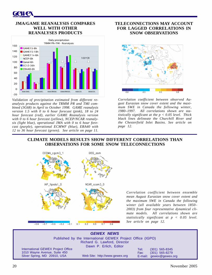
November 200520
Correlation coefficient between observed Au-gust Eurasian snow cover extent and the maxi-mum SWE in Canada the following winter,1980–1997. All correlations shown are sta-tistically significant at the p < 0.05 level. Thickblack lines delineate the Churchill River andthe Chesterfield Inlet Basins. See article onpage 12.
Correlation coefficient between ensemblemean August Eurasian snow cover extent andthe maximum SWE in Canada the followingwinter (all available years between 1850–2003) from four representative dynamical cli-mate models. All correlations shown arestatistically significant at p < 0.05 level.See article on page 12.
-0.8 -0.5 0.5 0.8
Validation of precipitation estimated from different re-analysis products against the TRMM PR and TMI com-bined (3G68) in April to October 1998. GAME reanalysisversion 1.5 with 0 to 6 hour forecast (pink), 18 to 24hour forecast (red), earlier GAME Reanalysis versionwith 0 to 6 hour forecast (yellow), NCEP/NCAR reanaly-sis (light blue), operational JMA with 0 to 6 hour fore-cast (purple), operational ECMWF (blue), ERA40 with12 to 36 hour forecast (green). See article on page 11.
JMA/GAME REANALYSIS COMPARESWELL WITH OTHER
REANALYSES PRODUCTS
TELECONNECTIONS MAY ACCOUNTFOR LAGGED CORRELATIONS IN
SNOW OBSERVATIONS
CLIMATE MODELS RESULTS SHOW DIFFERENT CORRELATIONS THANOBSERVATIONS FOR SOME SNOW TELECONNECTIONS
GEWEX NEWSPublished by the International GEWEX Project Office (IGPO)
Richard G. Lawford, DirectorDawn P. Erlich, Editor
International GEWEX Project Office1010 Wayne Avenue, Suite 450Silver Spring, MD 20910, USA
Tel: (301) 565-8345Fax: (301) 565-8279E-mail: [email protected] Site: http://www.gewex.org