precautions and strategies to minimise · pdf fileinterventions for tsunami mitigation using...
TRANSCRIPT
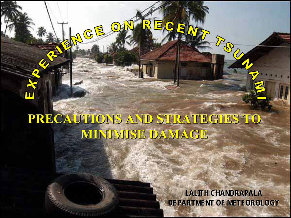
PRECAUTIONS AND STRATEGIES TO PRECAUTIONS AND STRATEGIES TO MINIMISE DAMAGEMINIMISE DAMAGE
LALITH CHANDRAPALALALITH CHANDRAPALADEPARTMENT OF METEOROLOGYDEPARTMENT OF METEOROLOGY
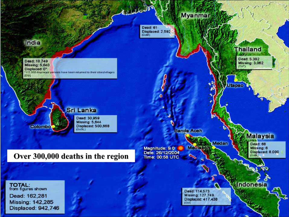
Over 300,000 deaths in the regionOver 300,000 deaths in the region
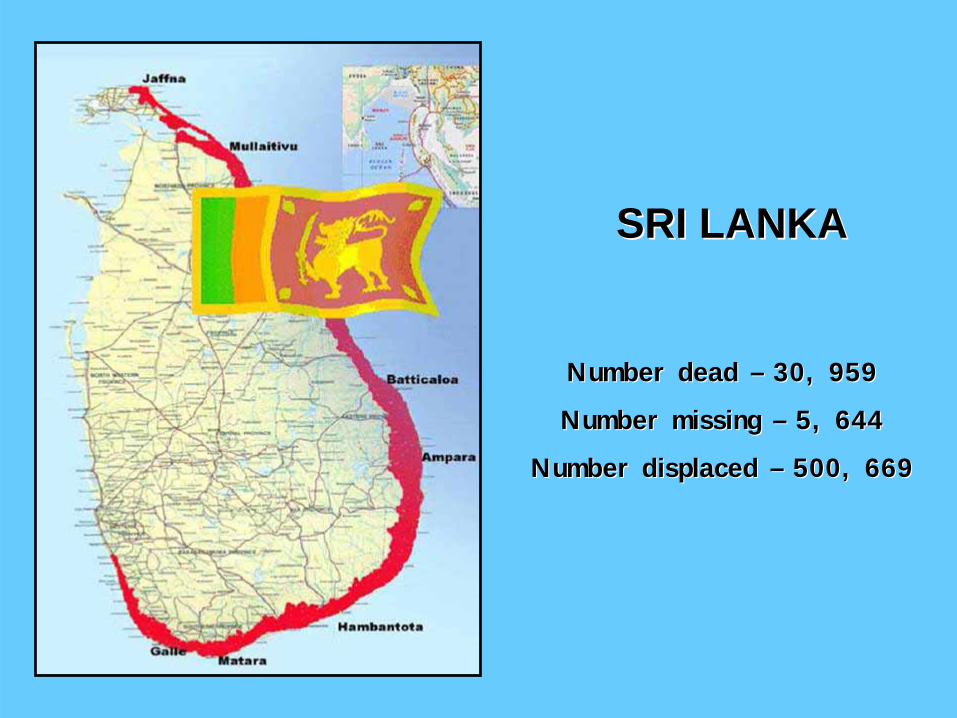
Number dead Number dead –– 30, 95930, 959
Number missing Number missing –– 5, 6445, 644
Number displaced Number displaced –– 500, 669500, 669
SRI LANKASRI LANKA
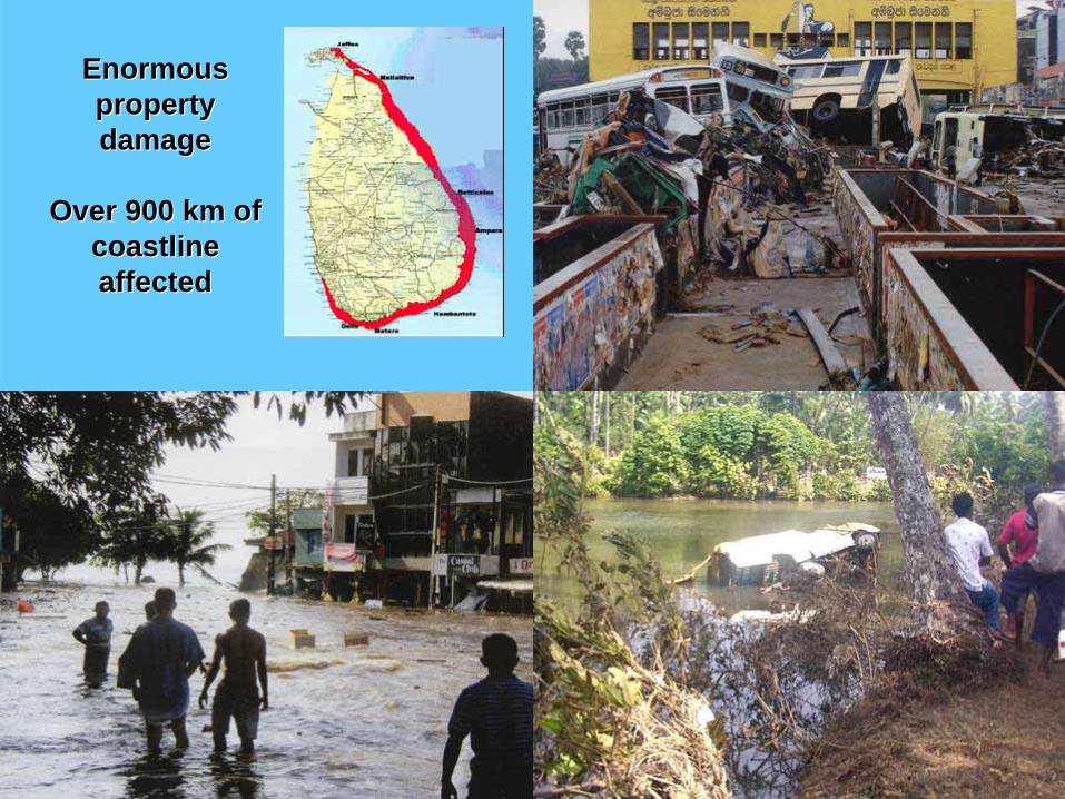
Enormous Enormous property property damagedamage
Over 900 km of Over 900 km of coastlinecoastlineaffectedaffected
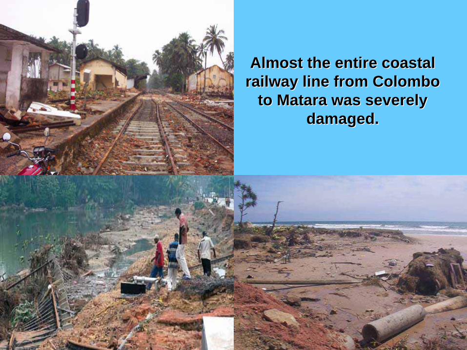
Almost the entire coastal Almost the entire coastal railway line from Colombo railway line from Colombo
to to MataraMatara was severely was severely damaged.damaged.
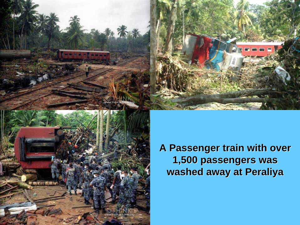
A Passenger train with over A Passenger train with over 1,500 passengers was 1,500 passengers was
washed away at Peraliyawashed away at Peraliya

Indian Ocean Tsunami of 26Indian Ocean Tsunami of 26--1212--20042004
Time of arrival of first wave and estimated max. wave heightTime of arrival of first wave and estimated max. wave height
08:30 (7-12 m)
08:40 (6-10 m)
08:50 (5-8 m)
09:00 (3-5 m)
08:50 (7-9 m)
09:00 (7-9 m)(4-9 m) 09:15
(4-5 m) 09:20
(2 m) 09:30
Note: Earthquake occurred at 06:58 am

Tsunami Sources:Tsunami Sources:
Generally by strong submarineGenerally by strong submarine earthquakesearthquakese.g. Indian Ocean Tsunami, 2004e.g. Indian Ocean Tsunami, 2004
Less commonly by submarineLess commonly by submarine landslideslandslidese.g. Lithua Bay 1958e.g. Lithua Bay 1958
Infrequently byInfrequently by volcanic eruptionsvolcanic eruptionse.g. Karakatoa eruption in 1883e.g. Karakatoa eruption in 1883
Very rarely byVery rarely by meteorite impactmeteorite impactNone in recorded historyNone in recorded history
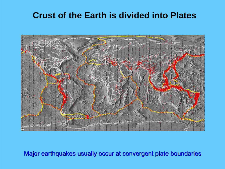
Crust of the Earth is divided into Plates
Major earthquakes usually occur at convergent plate boundariesMajor earthquakes usually occur at convergent plate boundaries

Three types of plate boundaries
Divergent boundaries
Convergent boundariesTransform boundaries
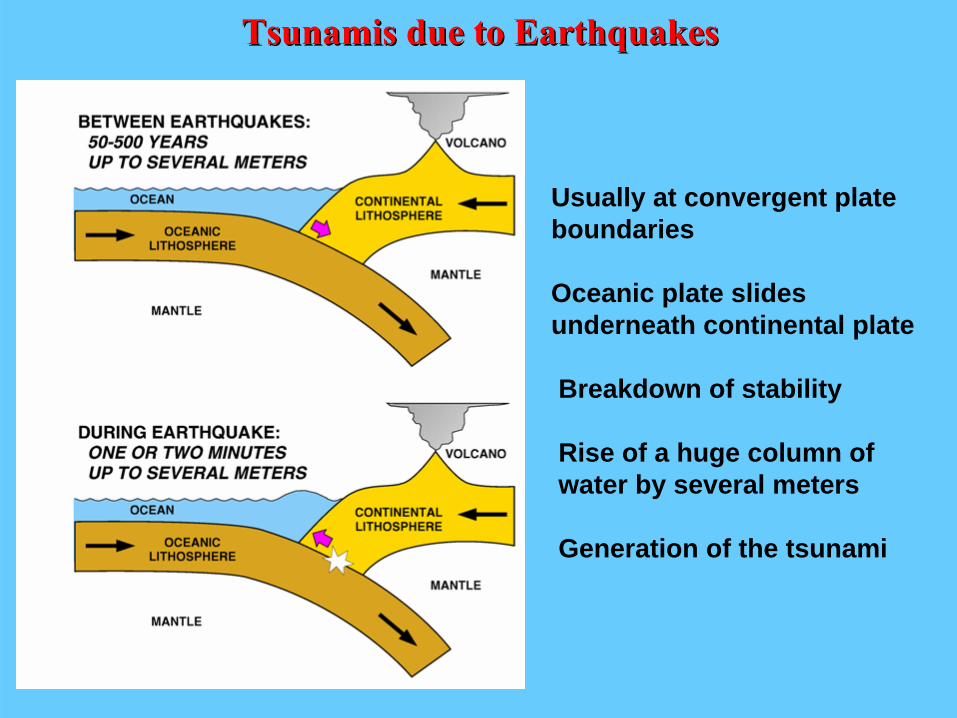
Tsunamis due to EarthquakesTsunamis due to Earthquakes
Usually at convergent plateboundaries
Oceanic plate slides underneath continental plate
Breakdown of stability
Rise of a huge column of water by several meters
Generation of the tsunami
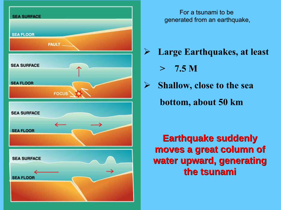
Large Earthquakes, at least
> 7.5 M
Shallow, close to the sea
bottom, about 50 km
Earthquake suddenly Earthquake suddenly moves a great column of moves a great column of water upward, generating water upward, generating
the tsunamithe tsunami
For a tsunami to be generated from an earthquake,
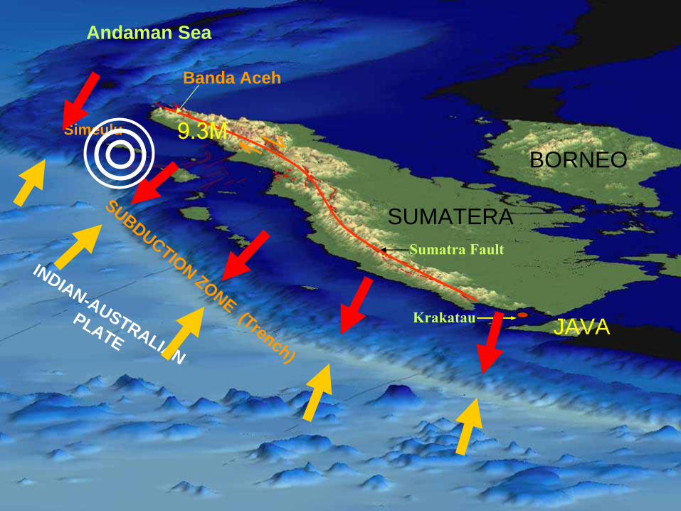
INDIAN-AUSTRALIAN
PLATE
SUBDUCTION ZONE (Trench)
SUMATERA
BORNEO
JAVA
Banda Aceh
Simeulu
Andaman Sea
Sumatra Fault
Krakatau
9.3M

TsunamigenicTsunamigenic RegionsRegions
Large earthquakes generally occur near boundaries of tectonic plates

TsunamigenicTsunamigenic Regions in the Indian OceanRegions in the Indian Ocean
MAKRAN ZONEMAKRAN ZONE(Pakistan-Iran border)
Last major Tsunami in 1945
SUMATRA-INDONESIAN ZONE - SUNDA TRENCHSUNDA TRENCH
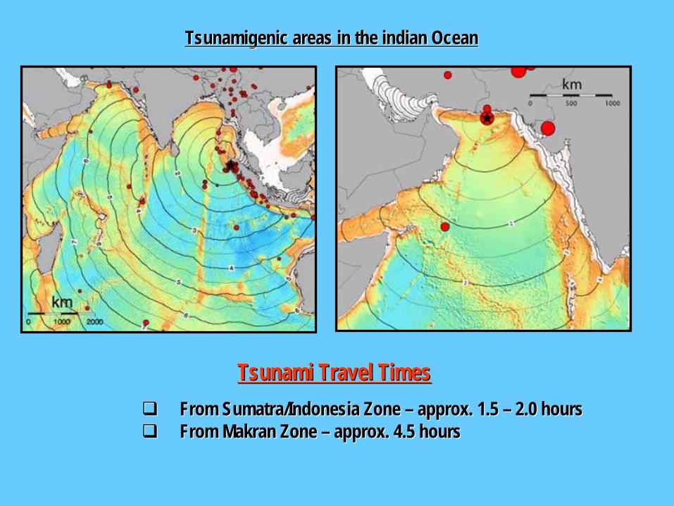
Tsunami Travel TimesTsunami Travel TimesFrom Sumatra/Indonesia Zone From Sumatra/Indonesia Zone –– approx. 1.5 approx. 1.5 –– 2.0 hours2.0 hoursFrom From MakranMakran Zone Zone –– approx. 4.5 hoursapprox. 4.5 hours
TsunamigenicTsunamigenic areas in the areas in the indianindian OceanOcean

Propagation of Tsunami WavesPropagation of Tsunami Waves
Wave Speed α ( h ) ½Where h is the depth of sea
Propagate at high speed in deep sea
Speed slows down near coastline

Tsunami Propagation SpeedTsunami Propagation Speed

Increase in Height/Speed and formation of Eddies
Concentration of wave energy
depth contoursIn
coming wa
ve ra
ys
Characteristics influenced by the shape and geometry
Energy concentration at headlands and in bays
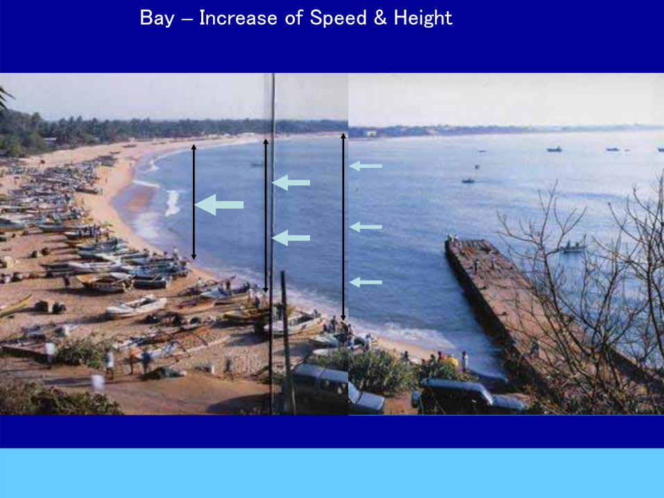
Bay – Increase of Speed & Height

Unawatuna - concentration of energy and spreading around the headland

Headland – concentration of energy and
spreading around the headland
Relevance of Tsunami Breakwaters
Bay – increase of speed & height and circulation
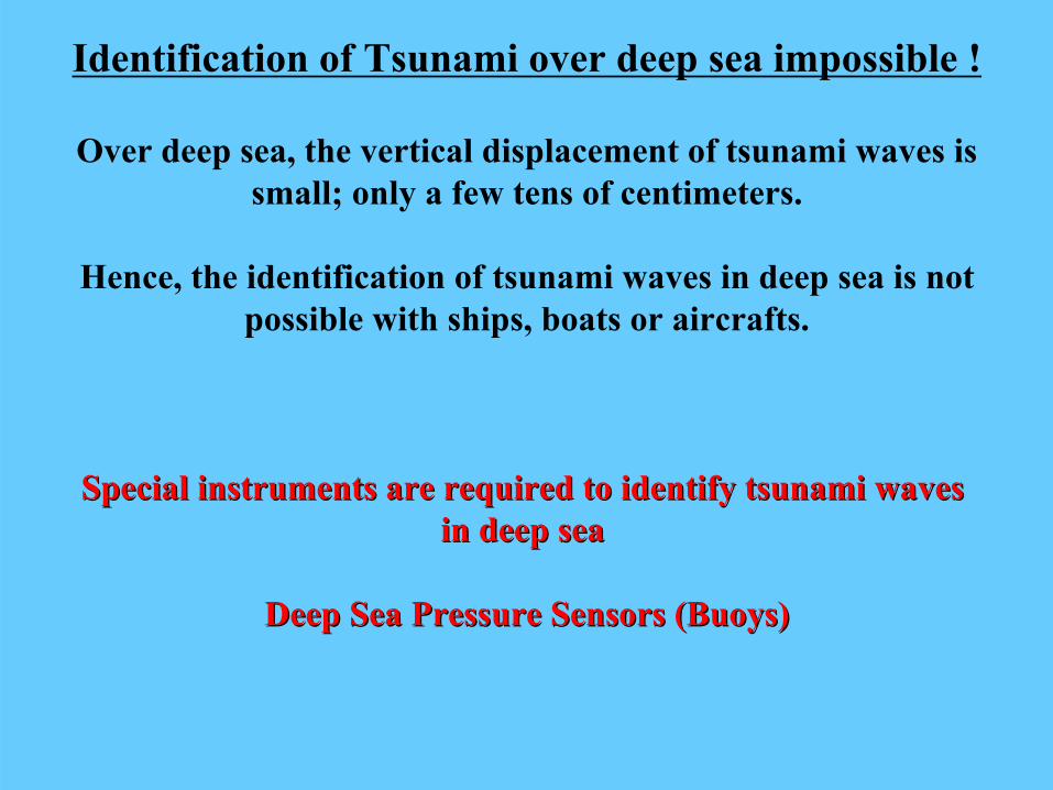
Identification of Tsunami over deep sea impossible !
Over deep sea, the vertical displacement of tsunami waves is small; only a few tens of centimeters.
Hence, the identification of tsunami waves in deep sea is not possible with ships, boats or aircrafts.
Special instruments are required to identify tsunami waves Special instruments are required to identify tsunami waves in deep sea in deep sea
Deep Sea Pressure Sensors (Buoys)Deep Sea Pressure Sensors (Buoys)

Deep Sea BUOYS
How the Buoys detect
Tsunami Waves
Pressure sensorPressure sensor
Very expensive instrumentCostly to maintain
None in operation in the Indian OceanNone in operation in the Indian Ocean
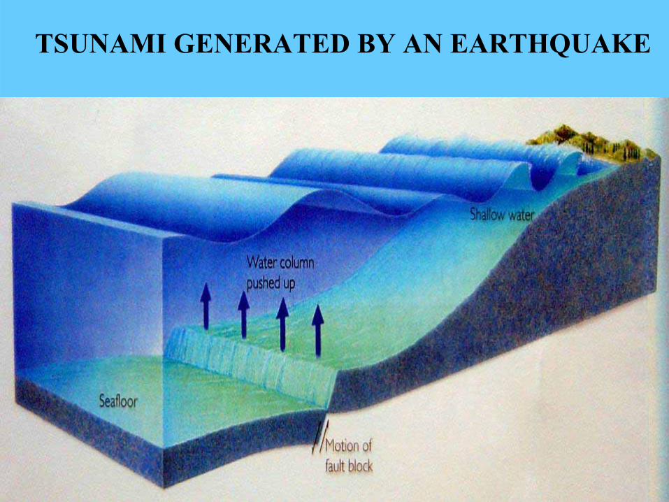
TSUNAMI GENERATED BY AN EARTHQUAKE
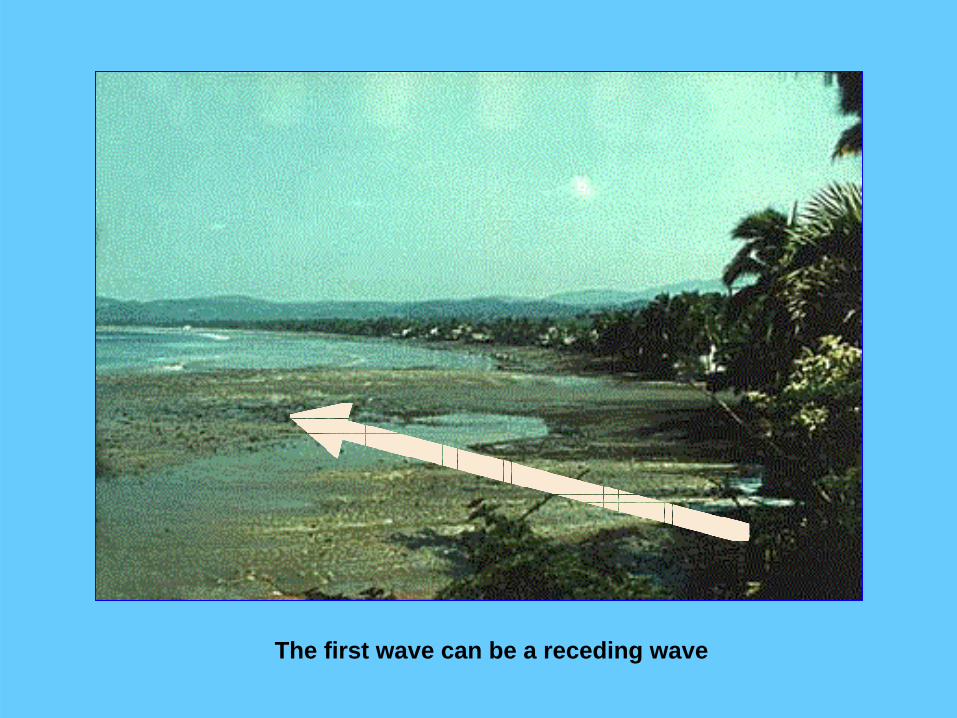
The first wave can be a receding wave

400 m
Receding waters at Kalutara
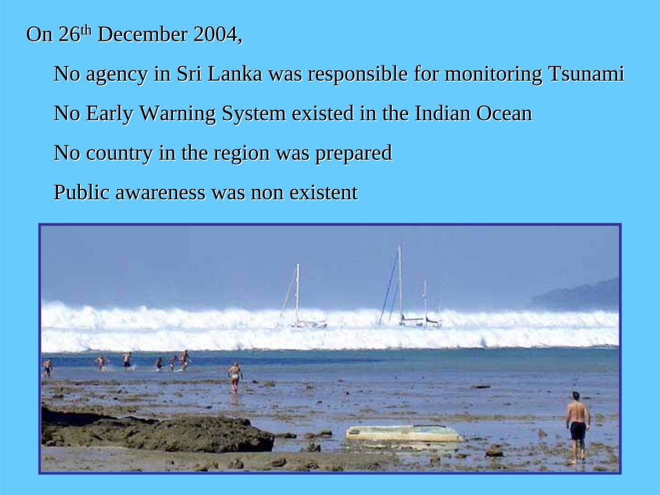
On 26On 26thth December 2004,December 2004,
No agency in Sri Lanka was responsible for monitoring TsunaNo agency in Sri Lanka was responsible for monitoring Tsunamimi
No Early Warning System existed in the Indian OceanNo Early Warning System existed in the Indian Ocean
No country in the region was preparedNo country in the region was prepared
Public awareness was non existent Public awareness was non existent
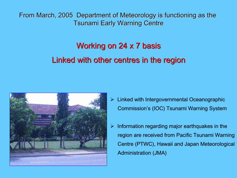
From March, 2005 Department of Meteorology is functioning as thFrom March, 2005 Department of Meteorology is functioning as the e Tsunami Early Warning CentreTsunami Early Warning Centre
Working on 24 x 7 basisWorking on 24 x 7 basis
Linked with other centres in the regionLinked with other centres in the region
Linked with Intergovernmental OceanographicCommission’s (IOC) Tsunami Warning System
Information regarding major earthquakes in the region are received from Pacific Tsunami WarningCentre (PTWC), Hawaii and Japan MeteorologicalAdministration (JMA)
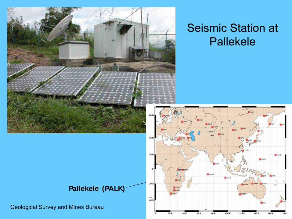
Pallekele (PALK)
Seismic Station at Pallekele
Geological Survey and Mines Bureau

Near real time Earthquake Display System of Near real time Earthquake Display System of California Integrated Seismic Network (CISN)California Integrated Seismic Network (CISN)
In addition, Tsunami Early Warning Centre receives earthquake information from California Integrated Seismic Network (CISN) and from USGS
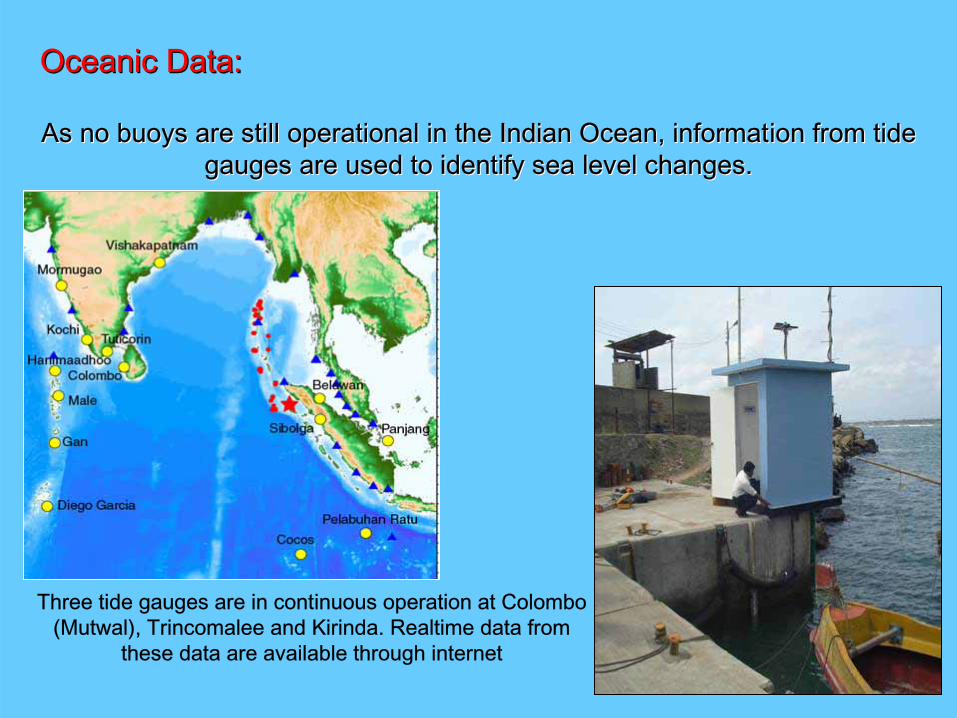
Oceanic Data:Oceanic Data:
As no buoys are still operational in the Indian Ocean, informatiAs no buoys are still operational in the Indian Ocean, information from tide on from tide gauges are used to identify sea level changes.gauges are used to identify sea level changes.
Three tide gauges are in continuous operation at Colombo (Mutwal), Trincomalee and Kirinda. Realtime data from
these data are available through internet

How the tide gauge at How the tide gauge at MutwalMutwal recorded the Tsunamirecorded the Tsunami
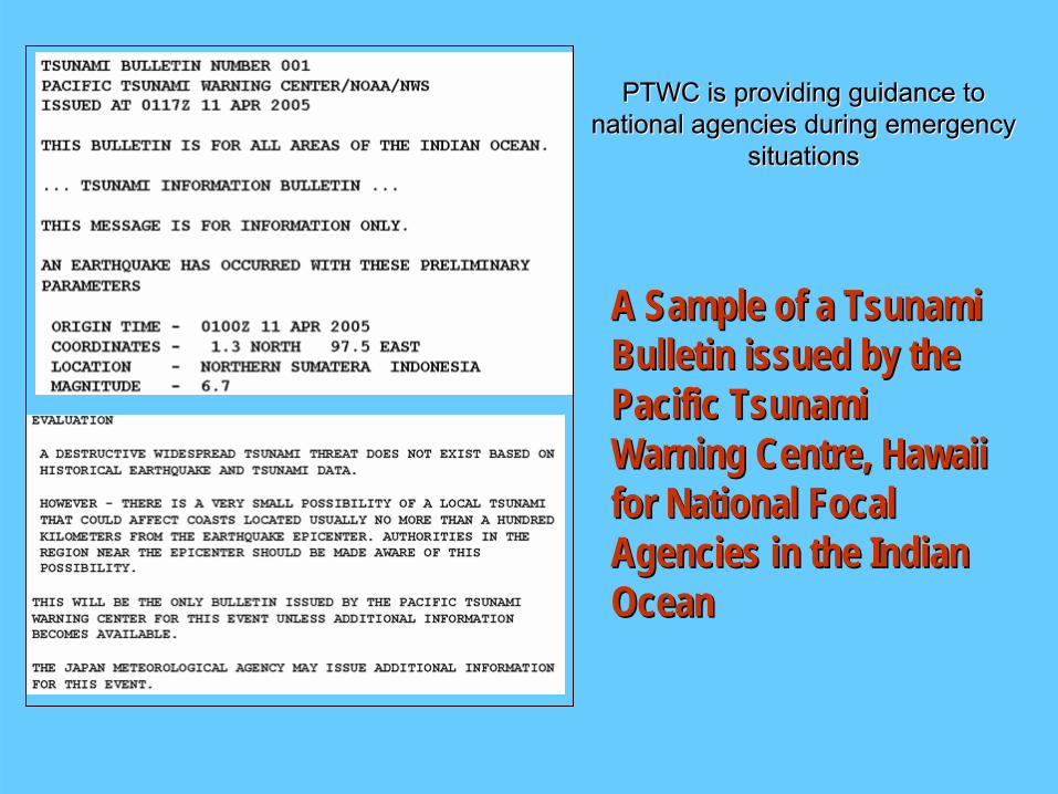
A Sample of a Tsunami A Sample of a Tsunami Bulletin issued by the Bulletin issued by the Pacific Tsunami Pacific Tsunami Warning Centre, Hawaii Warning Centre, Hawaii for National Focal for National Focal Agencies in the Indian Agencies in the Indian OceanOcean
PTWC is providing guidance to PTWC is providing guidance to national agencies during emergency national agencies during emergency
situationssituations

WarningWarning DisseminationDissemination
Through Mass Media Through Mass Media –– Radio and TelevisionRadio and Television
(message passed through telephone)
Through Local Police StationsThrough Local Police Stations
(message passed through telephone to Mirihana and thereafter HF)
Through Communication systems of Armed ForcesThrough Communication systems of Armed Forces
(Telephone/Telefax)
Through District Units of DMCThrough District Units of DMC
(Telephone/Telefax)
Planned:Planned:SMS disseminationSMS dissemination
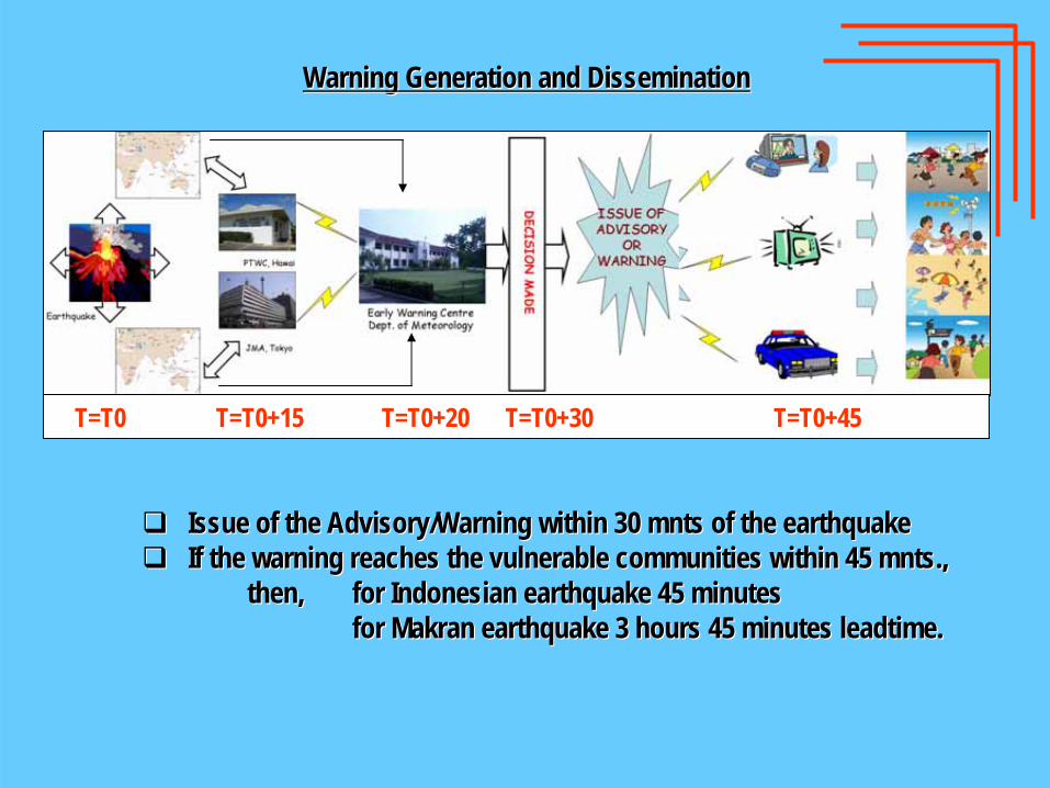
T=T0 T=T0+15 T=T0+20 T=T0+30 T=T0+45
Warning Generation and DisseminationWarning Generation and Dissemination
Issue of the Advisory/Warning within 30 Issue of the Advisory/Warning within 30 mntsmnts of the earthquakeof the earthquakeIf the warning reaches the vulnerable communities within 45 If the warning reaches the vulnerable communities within 45 mntsmnts.,.,
then,then, for Indonesian earthquake 45 minutesfor Indonesian earthquake 45 minutesfor for MakranMakran earthquake 3 hours 45 minutes earthquake 3 hours 45 minutes leadtimeleadtime..
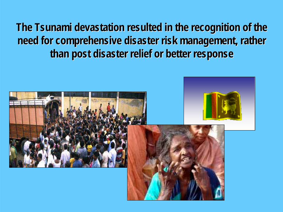
The Tsunami devastation resulted in the recognition of the The Tsunami devastation resulted in the recognition of the need for comprehensive disaster risk management, rather need for comprehensive disaster risk management, rather
than post disaster relief or better responsethan post disaster relief or better response

PostPost--Tsunami Developments in Sri LankaTsunami Developments in Sri Lanka
•• Disaster Management Act No. 13 of 2005 enactedDisaster Management Act No. 13 of 2005 enacted
•• National Council for Disaster Management (NCDM) National Council for Disaster Management (NCDM)
•• Disaster Management CentreDisaster Management Centre
•• Ministry of Disaster Management and Human RightsMinistry of Disaster Management and Human Rights
Some of the majorSome of the major

Disaster ManagementAct No. 13 of 2005
Enacted on 13th May 2005
A legal basis for disaster management . . .A legal basis for disaster management . . .

National Council for National Council for Disaster Management Disaster Management
(NCDM)(NCDM)
Chairperson Chairperson –– H.E. the PresidentH.E. the President
Vice Chairperson Vice Chairperson –– Hon. Prime MinisterHon. Prime Minister
Leader of the OppositionLeader of the Opposition
Ministers inMinisters in--charge of the following subject areas:charge of the following subject areas:Social WelfareSocial Welfare Rehabilitation and ReconstructionRehabilitation and Reconstruction
EnvironmentEnvironment Home AffairsHome Affairs
HealthHealth Science and TechnologyScience and Technology
HousingHousing Coast ConservationCoast Conservation
IrrigationIrrigation ElectricityElectricity
DefenceDefence PolicePolice
FinanceFinance LandLand
Fisheries and Fisheries and AqAq. Res. . Res. Foreign AffairsForeign Affairs
Water SupplyWater Supply Urban DevelopmentUrban Development
EducationEducation HighwaysHighways
Chief Ministers of all Provincial CouncilsChief Ministers of all Provincial Councils
05 Opposition Members from Parliament05 Opposition Members from Parliament

National Council for Disaster Management (NCDM)
Disaster Management Centre Disaster Management Centre (DMC)(DMC)
DirectorDirector--GeneralGeneral National Consultants
Disaster Management
Technology & Long term Mitigation
-Hazard Mapping, Risk
Assessment, Data Collection, Research,
Analysis-
1 Director1 Director1 Asst. Director1 Asst. Director
Forecasting, Early Warning and
Dissemination-
Forecasting, Early Warning and EW
Dissemination (end-to-end)
-
1 Director3 Asst. Directors
Preparedness Planning
-
Prearation of Disaster
Preparedness Plans at National and sub
national levels-
1 Director2 Asst. Directors
Training, Education and Awareness
-
Training, Education and Public Awareness
-
1 Director3 Asst. Directors
National Emergency Operations
-
Activate operations and emergency
response at national/sub-
national levels-
1 Director3 Dep. Directors3 Asst. Director
Personnel and Administration
1 Deputy Director
Finance
1 Deputy Director
External and Internal Relations and Media
1 Deputy Director
25 nos. District
Coordinators
Structure of the DMC
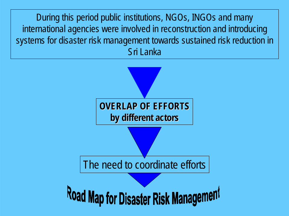
During this period public institutions, NGOs, INGOs and many international agencies were involved in reconstruction and introducing
systems for disaster risk management towards sustained risk reduction in Sri Lanka
OVERLAP OF EFFORTSOVERLAP OF EFFORTSby different actorsby different actors
The need to coordinate efforts
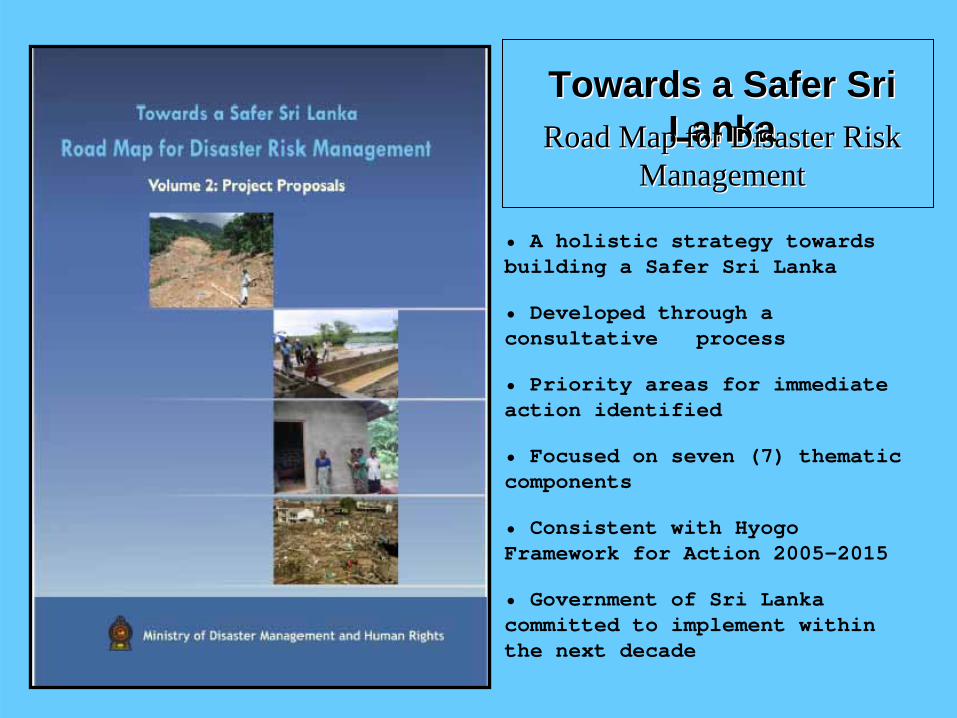
Towards a Safer Sri Towards a Safer Sri LankaLankaRoad Map for Disaster Risk Road Map for Disaster Risk
ManagementManagement
• A holistic strategy towards building a Safer Sri Lanka
• Developed through a consultative process
• Priority areas for immediate action identified
• Focused on seven (7) thematic components
• Consistent with Hyogo Framework for Action 2005-2015
• Government of Sri Lanka committed to implement within the next decade
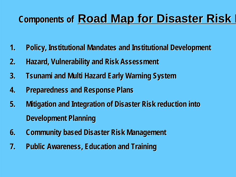
Components ofComponents of Road Map for Disaster Risk MRoad Map for Disaster Risk M
1.1. Policy, Institutional Mandates and Institutional DevelopmentPolicy, Institutional Mandates and Institutional Development
2.2. Hazard, Vulnerability and Risk AssessmentHazard, Vulnerability and Risk Assessment
3.3. Tsunami and Multi Hazard Early Warning SystemTsunami and Multi Hazard Early Warning System
4.4. Preparedness and Response PlansPreparedness and Response Plans
5.5. Mitigation and Integration of Disaster Risk reduction intoMitigation and Integration of Disaster Risk reduction into
Development PlanningDevelopment Planning
6.6. Community based Disaster Risk ManagementCommunity based Disaster Risk Management
7.7. Public Awareness, Education and TrainingPublic Awareness, Education and Training
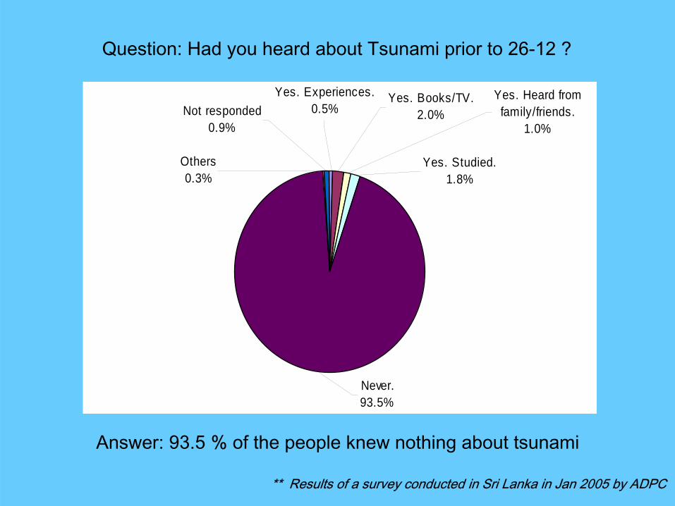
Yes. Heard fromfamily/friends.
1.0%
Yes. Studied.1.8%
Never.93.5%
Others0.3%
Not responded0.9%
Yes. Books/TV.2.0%
Yes. Experiences.0.5%
Question: Had you heard about Tsunami prior to 26-12 ?
Answer: 93.5 % of the people knew nothing about tsunami
** Results of a survey conducted in Sri Lanka in Jan 2005 by ADPC
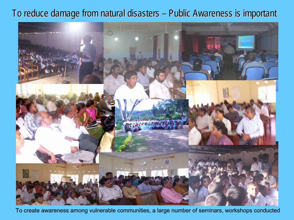
To reduce damage from natural disasters To reduce damage from natural disasters –– Public Awareness is importantPublic Awareness is important
To create awareness among vulnerable communities, a large number of seminars, workshops conducted
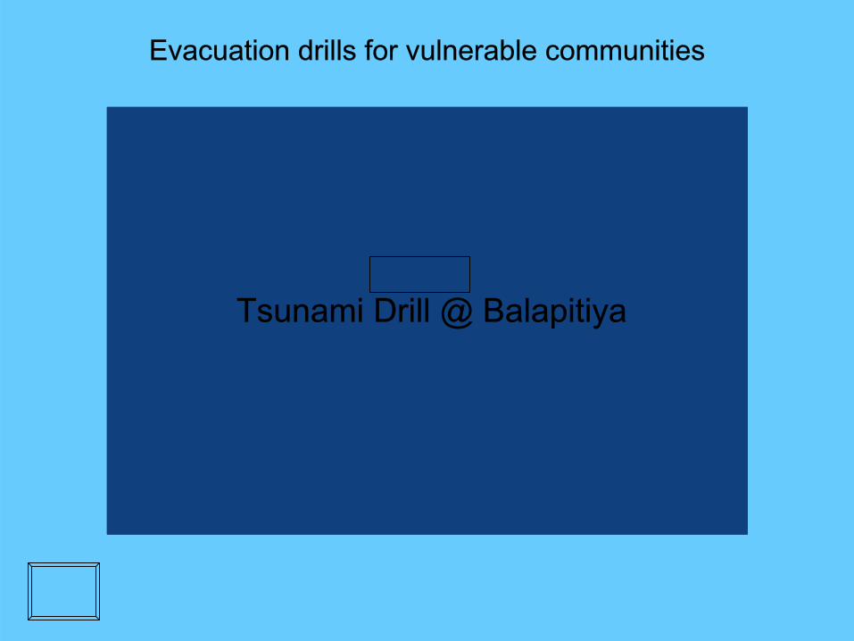
Evacuation drills for vulnerable communities
Tsunami Drill @ Balapitiya

Programs for School Children
C W W C W W KannangaraKannangara VidyalayaVidyalaya, Galle, Galle
School Drill @ Galle

Similar programs are continuing in vulnerable coastal regionsUnder the supervision of District Disaster Management Coordinators
to ensure effective response to hazard impact
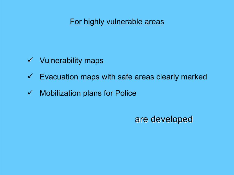
For highly vulnerable areas
Vulnerability maps
Evacuation maps with safe areas clearly marked
Mobilization plans for Police
are developedare developed
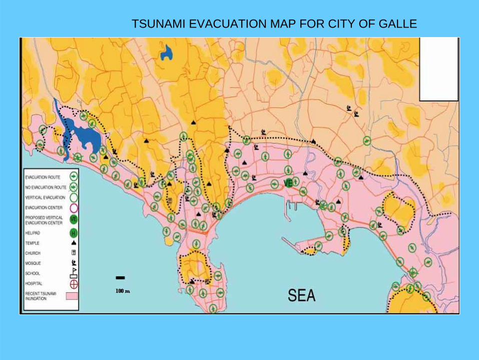
TSUNAMI EVACUATION MAP FOR CITY OF GALLE

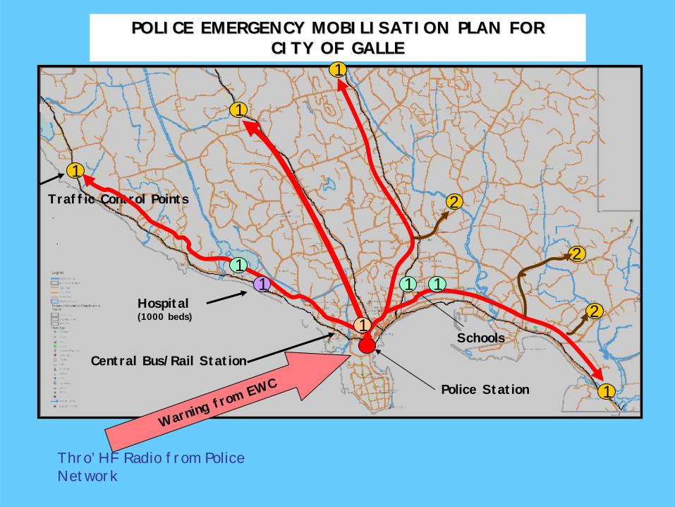
POLICE EMERGENCY MOBILISATION PLAN FOR POLICE EMERGENCY MOBILISATION PLAN FOR CITY OF GALLECITY OF GALLE
Police Station
Warning fro
m EWC
1
1
1
1
1
2
2
2Hospital(1000 beds)
Central Bus/Rail Station
Schools
Traffic Control Points
11 1
1
Thro’ HF Radio from Police Network


Vulnerability mapVulnerability map
under developmentunder development
for Bentotafor Bentota--BeruwalaBeruwala
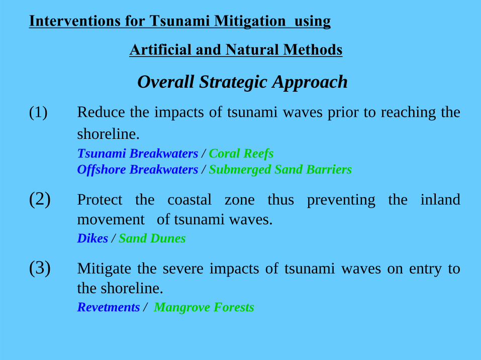
Interventions for Tsunami Mitigation using
Artificial and Natural Methods
Overall Strategic Approach(1) Reduce the impacts of tsunami waves prior to reaching the
shoreline.Tsunami Breakwaters / Coral Reefs Offshore Breakwaters / Submerged Sand Barriers
(2) Protect the coastal zone thus preventing the inland movement of tsunami waves.Dikes / Sand Dunes
(3) Mitigate the severe impacts of tsunami waves on entry to the shoreline.Revetments / Mangrove Forests

Reduce the impacts of tsunami waves prior to reaching the shoreline
Protect the coastal zone thus preventing the inland movement of tsunami waves
Mitigate the severe impacts of tsunami waves on entry to the shoreline
Dykes RevetmentsBreak waters
ARTIFICIAL METHODS:ARTIFICIAL METHODS:

Reduce the impacts of tsunami waves prior to reaching the shoreline
Protect the coastal zone thus preventing the inland movement of tsunami waves
Mitigate the severe impacts of tsunami waves on entry to the shoreline
Breakwaters Dykes RevetmentsSubmerged sandbars/coral reefs Sand dunes Mangroves
NATURAL METHODS:NATURAL METHODS:

Tsunami Dike and Tsunami Gate in Japan
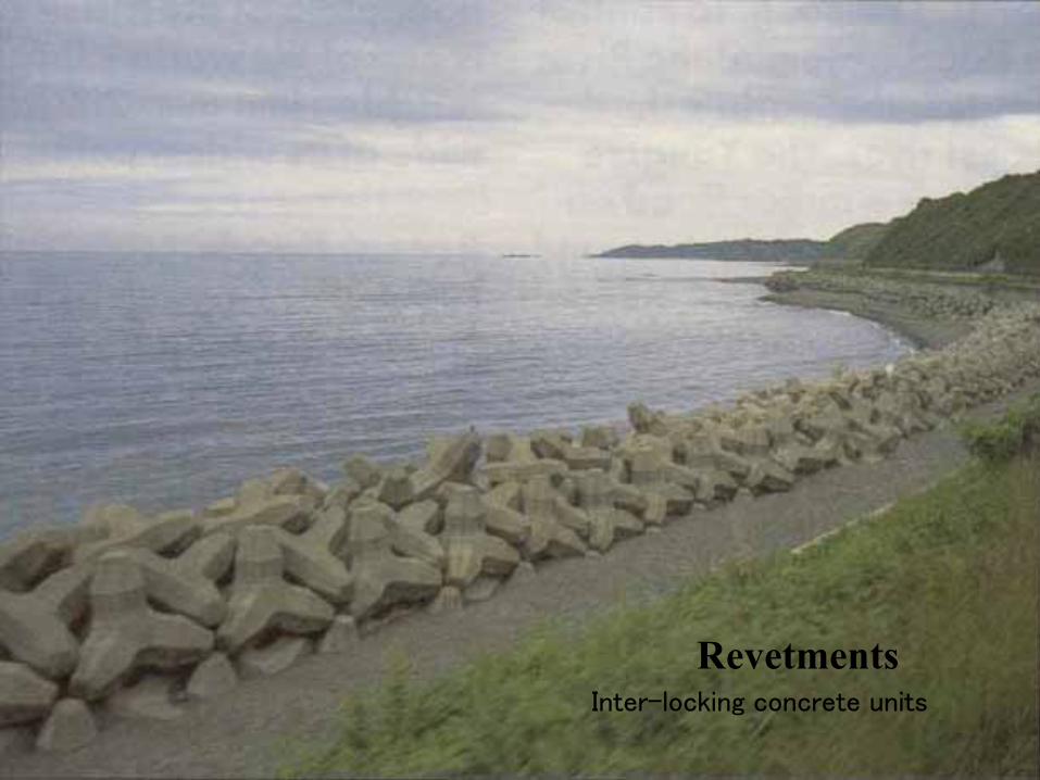
Inter-locking concrete units
Revetments

Off-shore Breakwaters
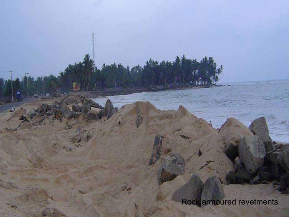
Rock armoured revetments
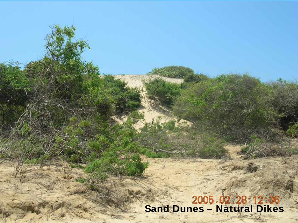
Sand Dunes – Natural Dikes

Submerged Offshore SandbarsSubmerged Offshore Sandbars

THANK YOUTHANK YOU