pre-feasibility report -...
TRANSCRIPT

PRE-FEASIBILITY REPORT (Under the Guidelines of Ministry of Environment and Forest in terms of the provisions of
EIA notification 2006 and specifically in circular No J-11013/41/2006-IA.II (I) dated 30th December, 2010)
Minor Mineral – Rough stone
Mining Project – Category “B2”
Lease Area – 2.50.0Ha
S.F.No. - 346/2 (Part-II)
Village – Nadumandalam
Taluk – Natham
District – Dindigul
State – Tamilnadu
PROJECT PROPONENT
S.K.Balasubramanian,
H3, R.M.Colony, Dindigul.
Consultant
GEO EXPLORATION AND MINING SOLUTIONS
Old No. 260-B, New No. 17,
Advaitha Ashram Road,
Alagapuram, Salem – 636 004
Tamilnadu, India. An Accredited Organization under
Quality Council of India – National Accreditation Board for Education & Training, New Delhi
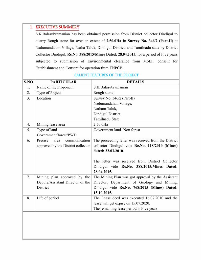
1. EXECUTIVE SUMMERY
S.K.Balasubramanian has been obtained permission from District collector Dindigul to
quarry Rough stone for over an extent of 2.50.0Ha in Survey No. 346/2 (Part-II) at
Nadumandalam Village, Natha Taluk, Dindigul District, and Tamilnadu state by District
Collector Dindigul, Rc.No. 388/2015/Mines Dated: 28.04.2015, for a period of Five years
subjected to submission of Environmental clearance from MoEF, consent for
Establishment and Consent for operation from TNPCB.
SALIENT FEATURES OF THE PROJECT
S.NO PARTICULAR DETAILS
1. Name of the Proponent S.K.Balasubramanian
2. Type of Project Rough stone
3. Location Survey No. 346/2 (Part-II)
Nadumandalam Village,
Natham Taluk,
Dindigul District,
Tamilnadu State.
4. Mining lease area 2.50.0Ha
5. Type of land
Government/forest/PWD
Government land- Non forest
6. Precise area communication
approved by the District collector
The proceeding letter was received from the District
collector Dindigul vide Rc.No. 118/2010 (Mines)
dated: 22.03.2010.
The letter was received from District Collector
Dindigul vide Rc.No. 388/2015/Mines Dated:
28.04.2015.
7. Mining plan approved by the
Deputy/Assistant Director of the
District
The Mining Plan was got approval by the Assistant
Director, Department of Geology and Mining,
Dindigul vide Rc.No. 768/2015 (Mines) Dated:
15.10.2015.
8. Life of period The Lease deed was executed 16.07.2010 and the
lease will get expiry on 15.07.2020.
The remaining lease period is Five years.

9. Production capacity The proposed quantity of reserves is to be mined is
74040m3(or) 13081 Lorry Loads of Rough stone up
to a depth for 16m below the ground level for a
period of Five years only.
Description
Rough
stone
in m3
Topsoil
in m3
Geological Resources 373680 24912
Available Mineable reserves 107990 -
Five years plan period
As in the approved mining plan
74040 -
10. Method of Mining The quarrying operation will be carried out by Semi
Mechanized Opencast Method in conjunction with
conventional method of mining using Jack hammer
drilling and slurry blasting, excavation, loading and
transportation of Rough stone to the needy crushers.
11. Ultimate depth of Mining Proposed depth of mining is 16m below the ground
level for a period of Five years only
12. Latitude 10°15’19"N to 10°15’25"N
13. Longitude 78°16’07"E to 78°16’14"E
14. Topo sheet No. 58 J/07
15. Topography of MSL area 256m from MSL
16. Land use classification It is a Fresh Quarry lease of Rough stone quarry (the
area has been quarrying operation earlier) in
Nadumandalam Village
17. Ground water level The Ground water is about 45mt depth from ground
level.
18. Climatic condition Rainfall – 850/annum
Temperature -42ºC - 23ºC
19. Land use pattern Description Present
area in Ha,
Area at the end of
the lease period Ha
Area under quarrying 1.89.1 1.89.1
Infrastructure 0.01.0 0.01.0
Roads 0.02.0 0.02.0
Green belt Nil 0.10.0
Unutilized 0.57.9 0.47.9
Grand Total 2.50.0 2.50.0
20. Nearest habitation Panniamalai – 1km – North easatern side
21. Nearest Town Natham - 5km – South western side
22. Nearest Railway station Dindigul Railway station - 32kms- NW side
23. Nearest Airport Madurai Airport - 50kms - SW side
24. Nearest National Highways &
State Highways
NH- 45B- Madurai – Trichy - 12Km on the E side.
SH-35 – Natham - Dindigul - 5Km on the S side.
25. Nearest Hospital Nadumandalam - 4km – North western side

26. Aerial distance to the nearest Eco
sensitive areas, CRZ, forest, wild
life sanctuary, Interstate
boundary, critically polluted area
if the quarry site is within 500m
of these areas.
More than 500m from Eco sensitive areas, CRZ,
forest, wild life sanctuary, Interstate boundary,
critically polluted area.
27. Details of other quarries for a
radius of 500m around the quarry
site
There are no quarries is situated within 500m radius
28. Man power About 10 employees
29. Water requirement & source Total water requirement for 1.0KLD
Purpose Quantity
KLD
Source
Drinking 0.3KLD Water vendors
Domestic purpose 0.3KLD Bore wells
Dust suppression and
afforestation
0.4KLD Bore wells
30. Overburden/Waste It is a elevated terrain the Overburden in the
form of top soil is was found intermediate the
Charnockite formation, the thickness of the topsoil is
1m. The top soil was removed during the previous
quarrying work. Hence no overburden anticipated in
the remaining period.
31. Cost of the project The Project cost:
A. Fixed asset cost = Rs. 10,50,000/-
B. Operational cost = Rs. 46,00,000/-
C. EMP Cost = Rs. 7,70,000/-
Total Cost (A+B+C) = Rs. 64,20,000/-
The Prefeasibility report preparing for following condition of Government of India Ministry of Environment and Forests (No.L-11011/47/2011 (IA-II (M) Dated: 24th June, 2013)
� The Reserve forest is situated within 5km & 6km away from NE & NW side.
� The River is situated within 11km away from North eastern side.
� There is no CRZ within the radius of 15km.
� There is no Western Ghats region is situated within 15km radius from the quarry side of
the area
� There is no ‘HACA’ region within the radius of 15km.
� There is no interstate boundary is situated within 15km radius
� There are no Bird sanctuaries, wild life sanctuary or National parks as per Wild life
protection Act 1972, within the radius of 15kms.

The following information provided by the applicant
I have applied for getting Environmental Clearance for quarry lease for quarrying of Rough
stone over on extent of 2.50.0Ha in S.F. No: 346/2 (Part-II) at Nadumandalam Village, Natham
Taluk and Dindigul District.
I will not deploy any child labors below 18 years for any type of quarrying operation. All labours
engaged for quarrying operation will be insured till the end of life of quarry period.
All type of safety / protective equipment’s will be provided to all the labourers working in my
quarry site.
I will sincerely follow and execute the Afforestation and Green belt as proposed during the
course of quarrying operation and maintain Afforestation after the expiry of quarrying lease.
I ensure to involve and participate in the corporate social responsibilities of the local community
as declared in the report.
The quarry operation has not been commenced and will likely to operate after grant of
Environmental clearance and grant of quarry lease.
I solemnly declare & affirm that there are no quarries within 500m radius from the periphery of
the quarry site.
Besides I wish to state that the approach roads belong to me only and no other patta roads are
encountered.
No habitations/Village is located within 500m radius from the periphery of my quarry.
The quarrying operation will not cause any hindrance to the nearby public and also it will not
cause any hindrance to nearby villagers and human settlements during transportation of mineral.
I wish to state there is no protected areas notified within the radius of 10km from the proposed
quarry site under the wildlife (Protection) Act 1972.
No Critically polluted areas as identified within the radius of 10km from the quarry site by
CPCB constituted under water (Prevention and control of pollution) Act 1974.
No Eco sensitive areas as identified within the radius of 10km from the proposed quarry site.
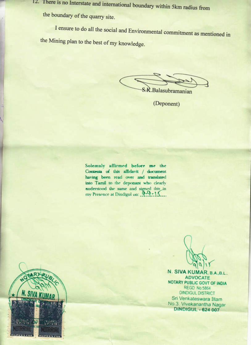
There is no interstate and international boundary within 5km radius from the boundary of the
quarry site.

2.0 INTRODUCTION OF THE PROJECT OR BACKGROUND INFORMATION
(i) Identification of project and project proponent: In case of mining project, a copy of mining
lease/letter of intent should be given
Identification of Project
Name of the Project Nadumandalam Rough stone Quarry
Lease area 2.50.0Ha (Government land) - Non forest
Location Survey No. 346/2 (Part-II)at Nadumandalam Village, Natham
Taluk, Dindigul District, and Tamilnadu State.
Background information of the Project
Nadumandalam Rough stone quarry of S.K.Balasubramanian has applied for Mining
lease over an area of 2.50.0Ha in the Survey No. 346/2 (Part-II) at Nadumandalam Village,
Natham Taluk and Dindigul District. The area falls in GSI Topo sheet no: 58 J/07. It is a
Government Poramboke land the lessee has obtained tender from the Government. The lease
applied area is exhibits slightly elevated topography.
Project Proponent Name with Address
S.K.Balasubramanian,
H3, R.M.Colony,
Dindigul
Mobile No: 9842167789
Email id: [email protected]
In case of mining project, a copy of mining lease/letter of intent should be given
I. The proceeding letter was received from the District collector Dindigul vide Rc.No.
118/2010 (Mines) dated: 22.03.2010.
II. The letter was received from District Collector Dindigul vide Rc.No. 388/2015/Mines
Dated: 28.04.2015.
III. The Mining Plan was got approval by the Assistant Director, Department of Geology and
Mining, Dindigul vide Rc.No. 768/2015 (Mines) Dated: 15.10.2015.

(ii) Brief description of nature of the project
The Rough stone quarrying operation is proposed to carry out by conventional opencast
Semi mechanized method by formation of benches. Four benches are proposed with a height of
5mts on Rough stone. The width of each bench is proposed not less than the height. The quarry
operation involves jackhammer drilling; Slurry blasting and excavators are used for loading of
Rough stone to needy crushers.
The proposed quantity of reserves is 74040m3
of Rough stone for a period of Five years
only, It is a elevated terrain the Overburden in the form of top soil is was found intermediate the
Charnockite formation, the thickness of the topsoil is 1m. The top soil was removed during the
previous quarrying work. Hence no overburden anticipated in the remaining period. The quarry
operation is proposed up to depth for 16m below the ground level for a period of Five years only.
(iii) Need for the project and its importance to the country and or region
The Rough stone is important building material to our country and Region, it’s a vital
material for construction industries and the Rough stone quarrying project falls in the area of
Dindigul District, where plenty of Road widening projects are been carried Madurai – Trichy
(NH- 45B), Natham - Dindigul (SH– 35) is being under massive development hence a lot of
Rough stone is required for Granular sub base (GSB) and also for the culverts and bridges.
Besides catering domestic construction project.
Other infrastructure projects like building, Bridges are also under progress hence there is a
huge demand of Rough stone for public sector companies and local private sector projects.
The earning source in the targeted area is limited, most of the people in and around the
area depend upon the seasonal agriculture, much of the people migrate to nearby towns where
good, and industries and factories are growing up. Through this project will give employment
opportunities to 10 employees directly and 6 people indirectly Mineral Industries of the state
of Tamil Nadu provides employment opportunities for the people of the state as well as in the
specific project area. The Quarrying is one among the major core sector for industries, which
plays a vital process of country’s economic development.
(iv) Demand and supply gap
There is a huge demand of Rough stone in Dindigul District as many National Road
projects (NH-45B) connecting Madurai – Trichy is under massive development for its widening
and strengthening operation apart from this many bridges and fly overs are also being under

construction. There is a huge demand of Rough stone for infrastructure development of the state;
hence the project is significant to the state.
The Railway line from Dindigul – Trichy is also under progress where huge Rough stone
is required as Ballast. Other internal panchayat Roads, State Highway roads and Major District
Roads are also under progress, besides all these public works projects the Rough stone is widely
used for domestic construction project like Hospital, School, Government Building and Housing,
Construction. It is worth mentioning that the Rough stone of Dindigul District.
(v) Imports vs indigenous production
There is no import of Rough stone at present in India.
(vi) Export Possibility
There are no possibilities for export.
(vii) Domestic/Export Markets
The applicant after obtaining the lease will fetch a domestic market as mentioned earlier.
It is propose to sell Rough stone domestic needy crushers for roads project and other
infrastructure development projects for public and private sector companies.
(viii) Employment Generation (Direct and Indirect) due to the project
It is proposed to deploy about 10 employees directly and 6 persons will be indirectly
Benefited .The tentative man power required for the proposed Rough stone quarry shall be as
follows.
a. Skilled labor
Mines foreman/
Permit Mines Manager - 1
Excavator operator - 1
Co-Operator - 1
Jack hammer operator - 4
Blaster/ mate - 1
b. Semi-skilled
Watchman - 1
c. Unskilled – helper - 1
Total - 10
The above man power is adequate to meet out the production schedule and the machinery
strength envisaged in the mining plan and also to comply with the stationary provisions of quarry
safety regulation.
It is been ensured that the labours will not be deployed less than 18 years, No Child
labours will engaged or entertained for any kind of quarrying operations. All the labours
engaged for quarrying operations will be insured till the end of life of quarry.

3.0 PROJECT DESCRIPTION
(i) Type of project including interlinked and interdependent projects, if any
The Nadumandalam Rough stone quarry; it is an opencast semi mechanized quarry.
There is no interlinked & interdependent project.
(ii) Location (map showing general location, specific location, and project boundary & project
site layout) with coordinates
� The project is proposed for the quarrying of Rough stone at proposed capacity of
74040m3
from the Rough stone quarrying is about 2.50.0Ha in Nadumandalam
Village, Natham Taluk, and Dindigul District.
� The entire quarry lease area falls in, It is a Government Poramboke land the lessee
has obtained tender from the Government
� The Altitude of the area is above 256m (Maximum) from MSL.
� The area is mentioned in GSI Topo sheet No. 58 J/07
� The Latitude between of 10°15’19"N to 10°15’25"N
� The Longitude between of 78°16’07"E to 78°16’14"E on WGS 1984 datum.

LOCATION MAP OF THE PROJECT AREA WITH CO ORDINATES
PROJECT AREA
10°15’19"N to 10°15’25"N
78°16’07"E to 78°16’14"E

(iii) Details of alternate sites considered and the basis of selecting the proposed site, particularly
the environmental considerations gone into should be highlighted
There is no alternative sites examined, the entire Rough stone will be transported to the
needy crusher. This Rough stone quarry project is site specific.
(iv ) Size or magnitude of operation
The total area of the project is about 2.50.0Ha. It is proposed quantity is 74040m3 of
Rough stone for a period of Five years. The quarry proposed up to depth of 16m below the
ground level by conventional open cast semi mechanized quarrying operation involves
jackhammer drilling, slurry explosives blasting, hydraulic excavator attached with bucket are
used for loading and unloading the Rough stone from pithead to crushing site.
(v) Project description with process details (a schematic diagram/flow chart showing the
project layout, components of the project etc. should be given)
The project is mineral for Rough stone and the lease area comprises of 2.50.0Ha of
Government land. The quarrying operation is involved open cast semi mechanized mining with
5.0m vertical bench with a bench width is not a less than the bench height. The quarry operation
involves jackhammer drilling, slurry explosives blasting; Hydraulic excavators are used for
loading of Rough stone to needy crushers. It is proposed quantity is 74040m3 of Rough stone.
The period of quarry is Five years.
Topography:
The lease area exhibits slightly elevated topography, The massive Rough stone
formation is clearly inferred followed by the 1m (max) Topsoil. The slope is gentle towards
Southern side. The altitude of the area is 256m (Maximum) from MSL.
Regional geology:
Peninsular Gneiss forms the oldest rock formations, in which the massive formation of
Charnockite lies over with the rich accumulation of recent quaternary formation. On regional
scale the Charnockite body trends the strike direction N30°E, S30°W with dipping towards SE
60°. The general geological sequences of the rocks in this area are given below
AGE FORMATION
Recent Quaternary weathered formation (Topsoil)
---------Unconformity-----------
Archaean - Charnockite
Peninsular Gneiss complex
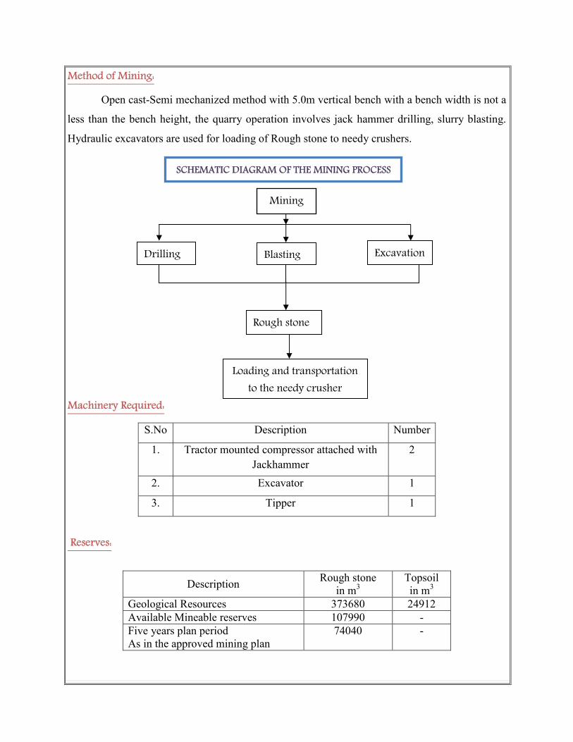
Method of Mining:
Open cast-Semi mechanized method with 5.0m vertical bench with a bench width is not a
less than the bench height, the quarry operation involves jack hammer drilling, slurry blasting.
Hydraulic excavators are used for loading of Rough stone to needy crushers.
Machinery Required:
S.No Description Number
1. Tractor mounted compressor attached with
Jackhammer
2
2. Excavator 1
3. Tipper 1
Reserves:
Description Rough stone
in m3
Topsoil
in m3
Geological Resources 373680 24912
Available Mineable reserves 107990 -
Five years plan period
As in the approved mining plan
74040 -
SCHEMATIC DIAGRAM OF THE MINING PROCESS
Mining
Excavation Blasting Drilling
Rough stone
Loading and transportation
to the needy crusher

(vi) Raw material required along with estimated quantity, likely source, marketing area of final
products, Mode of transport of raw Material and Finished Products
This is a quarrying project for exploiting of Rough stone; hence, there is no requirement
for raw material.
Uses:
The excavated Rough stone will be directly loaded into tipper to the needy crusher.
(vii) Resource optimization/recycling and reuse envisaged in the project, if any, should be
briefly outlined
Water will be accumulated in the excavated quarry out pit area during rainy season.
The water collected in the sump will be used in various purposes at quarry like plantation and
dust suppression etc.
(viii) Availability of water its source, Energy/power requirement and source should be given
This Rough stone quarry project does not require huge water and Electricity for the
project.
.
Purpose Quantity Sources
Drinking &
Domestic Purpose
0.3KLD Water purchase from Approved water
vendors available in Nadumandalam (4Km –
NW side).
Dust suppression 0.3 KLD From Existing Borehole on nearby the quarry.
Green belt 0.4 KLD From Existing Borehole on nearby the quarry.
Used only for drinking purpose for
operational workers
Dust Suppression in the Haul Roads to
prevent Dust emission and plantation.
0.3KLD of Drinking water &
Domestic purpose
0.3 KLD for Dust suppression
0.4 KLD for Green belt development
WATER
(1 KLD)
WATER BALANCE CHART

Energy
Electricity for Mines office and Lights only at nights (working is restricted on day time
only between 9Am to 5Pm). Diesel (HSD) will be used for quarrying machineries around 59232
Liters of HSD will be used for the entire project life. Diesel will be brought from nearby diesel
pumps. No power is required for the project. Lightings on the Night will be taken from nearby
electric poles after obtaining permission from concerned authorities.
1.For Rough stone:
Per hour Excavator will consume = 16 liters / hour
Per hour Excavator will excavate = 20m3of Rough stone
For 74040m3
= 74040/20
= 3702 hours
Diesel consume 3720 working hours = 3720 hours x 16 liters
Total diesel consumption = 59232 Liters of HSD will be utilized for Rough
Stone
1. Diesel consumption of Rough stone =59232 Liters
Total diesel consumption is around =59232 Liters of HSD for the entire period of life.
(ix) Quantity of wastes to be generated (liquid and solid) and scheme for their
management/disposal
Top soil: There is no topsoil.
Overburden/Waste: It is a elevated terrain the Overburden in the form of top soil is was found
intermediate the Charnockite formation, the thickness of the topsoil is 1m. The top soil was
removed during the previous quarrying work. Hence no overburden anticipated in the remaining
period.
Waste water: There will not be any process effluent generation from the quarry lease area.
Domestic effluent from the mine office is discharged in septic tank and soak pit.
There is no toxic effluent expected to generate in the form of solid liquid and gases and the no
requirement of treatment of waste.

(x) Schematic representations of the feasibility drawing which give information of EIA purpose
4.0 SITE ANALYSIS
(i) Connectivity
Mode Description
Road connectivity
1. There is a metal road on the South eastern side of the area
this road leads to Panniamalai village at a distance of 1km.
2. Nearest National Highway (NH- 45B) Madurai - Trichy -
12Km on the Eastern side of the area.
3. Nearest State Highway (SH-35) Natham - Dindigul -5Km
on the Southern side of the area.
Railway station &
Railway line
1. Nearest Railway station Dindigul - 32kms- NW side.
2. Nearest Railway line - Dindigul - Trichy - 30Km - NW
side of the area.
Air port 1. Nearest Airport is Madurai - 50kms – South western side
(ii) Land Form, Land use and Land ownership
The quarry lease applied area is 2.50.0 Ha. The area falls in GSI Topo sheet no. 58 J/07.
No forest land involved in this lease area. The applied area is exhibits slightly elevated
topography. It is a Government Poramboke land the lessee has obtained tender from the
Government.
(iii) Topography (along with map)
The lease area exhibits slightly elevated topography, The massive Rough stone formation
is clearly inferred followed by the 1m (max) Topsoil. The slope is gentle towards Southern side.
The altitude of the area is 256m (Maximum) from MSL.
Form – 1
Along with pre-feasibility report
&
Approved Mining plan with Annexure
To Submit
Final Presentation

(iv) Existing land use pattern (agriculture, non-agriculture, forest, water bodies (including area
under CRZ), shortest distances from the periphery of the project to periphery of the forests,
national park, wild life sanctuary, eco sensitive areas, water bodies (distance from the HFL of
the river), CRZ. In case of notified industrial area, a copy of the Gazette notification should be
given.
The quarry lease applied area is exhibits slightly elevated topography. The area is a dry
barren land devoid of Agriculture and Habitations. The land is not used for any specific
vegetation. No major water bodies in the vicinity of the area, Ground water occurrence in this
area are 45mt depth. The quarrying is restricted up to 16m below the ground level; hence the
quarry operation will not be affected by the ground water. The region experiences semi – humid
climate and there is scanty growth of vegetation in and around the lease applied area (seasonal
vegetation is mostly practiced).
� The Reserve forest is situated within 5km & 6km away from NE & NW side.
� The River is situated within 11km away from North eastern side.
� There is no Western Ghats region is situated within 15km radius from the quarry side of
the area
� There is no CRZ within the radius of 15km.
� There is no ‘HACA’ region within the radius of 15km.
� There is no interstate boundary is situated within 15km radius
� There are no Bird sanctuaries, wild life sanctuary or National parks as per Wild life
protection Act 1972, within the radius of 15kms.
� There are no quarries is situated within 500m radius.
(v) Existing Infrastructure
There is no existing infrastructure present in the applied area. A permanent mine office
has been proposed in the lease area. A well-equipped first aid facility will be made available.
Permanent rest shelter is proposed. At the quarry site, urinal and latrine are proposed.
Water for drinking purpose be supplied form the approved water vendors. A small water
tank is also proposed which will be used for water sprinkling, plantation etc.
(vi) Soil Classification
The massive Rough stone formation is clearly inferred followed by the 1m (max)
Topsoil. This land does not sustain any type of vegetation or Agriculture.

(vii) Climatic data form secondary sources
The area receives rainfall of about 850mm/ annum and the rainy season is mainly from
Oct - Jan during North East, monsoon. The summer is hot with maximum temperature of 42°C
and winter encounters a minimum temperature of 23°C.
(viii) Social infrastructure available
There is no social infrastructure within the radius of 1Km like schools, universities,
hospitals, prisons and community housing etc.
5. PLANNING BRIEF
(i) Planning Concept (type of industries, facilities, transportation etc) Town and Country
Planning/Development authority Classification
The total area of the project is about 2.50.0Ha. The proposed quantity is around 74040m3
of Rough stone for a period of Five years. Conventional Open cast semi mechanized quarrying
the quarry operation involves jackhammer drilling, slurry explosives blasting, excavator are used
for loading of Rough stone through tippers to the needy crusher.
There are no habitations or villages en-route between the quarry sites the loaded vehicles
are allowed to move only below 40Kms per hour on the roads. The haul roads are sprinkled
periodically to prevent dust.
Other facilities such as power, transportation and communication, social infrastructure
facilities are locally available near project site. Nearest town is Natham, facilities like
Dispensary, post office are available in Nadumandalam on the 4km on North western side.
(ii) Population projection
There are few villages located in this area within 5km radius; the approximate distance
and population are given below.
S.No Name of the Village
Approximate distance &
Direction from lease
applied area
Approximate
population
1. Panniamalai 1Km - NE 700
2. Nadumandalam 4Km - NW 800
3. Poolamalai 2Km - SE 500
4. Avichchippatti 2Km - SW 100
Basic human welfare Amenities such as Health Center, Schools, Communication
Facilities, and Commercial Centers etc are available at Nadumandalam located at a distance of
4kms on the North western side of the area.

(iii) Land use planning (breakup along with green belt etc.)
The land use planning of the quarry area of the total extent of 2.50.0Ha is given below
Description Present Area
(Ha.)
Area at the end of
lease period (Ha.)
Area under quarrying 1.89.1 1.89.1
Infrastructure 0.01.0 0.01.0
Roads 0.02.0 0.02.0
Green belt Nil 0.10.0
Unutilized 0.57.9 0.47.9
Grand Total 2.50.0 2.50.0
(iv) Assessment of Infrastructure Demand (Physical & Social)
The existing road facilities are already available which shall be used and maintained.
The labors requirement is drawn from the nearest villages. The labors will be brought by jeeps
and vans to the quarry site, Medical facilities are available near the project site, Government and
private hospitals and other basic amenities and infrastructure facilities like communication
center, school supermarket, bus stand are also available in Nadumandalam at a distance of 4kms
(NW). This quarry project will provide employment for about 10 persons directly.
(v) Amenities/Facilities
The simple methods adopted and the limited scale of activities involved in Rough stone
quarrying does not require High Tension Electric Power supply or huge worship facilities. The
quarrying work is restricted to one general shift during daytime 9.00am to 5.00pm with 1.00pm -
2.00pm lunch break. Major Machinery repair works are attended at Dindigul minor repairs are
carried out by the nearby mechanics. All facilities and amenities are available in Dindigul which
is 34Km on the North western side of the area.
Packaged drinking water will be brought from approved vendors. Mine office, storeroom,
toilet and first-aid room will be provided on permanent structures within the lease area after the
grant of lease.
6. PROPOSED INFRASTRUCTURE
(i) Industrial Area (Processing area)
There is no processing area proposed within the lease applied area.
(ii) Residential area (Non processing area)
There is no residential area within 500mts of the lease applied area.

(iii) Green Belt
All along the boundary barrier is selected for Green belt development by planting and
maintaining native species. The total area for proposed for Green belt is around 0.10.0Ha out of
2.50.0Ha. The estimated budget for plantation and maintenance of Green belt development
would be around Rs. 30,000/-
(iv) Social infrastructure
About 10 employees will be directly benefited and 6 persons will be indirectly benefited,
the lease ensure to share all responsible for special benefits like water, health care, Education
benefits, and promotion of socio cultural activities of the nearby villages.
(v) Connectivity (traffic and transportation road/ Rail/ Metro/ Water ways etc.,)
Mode Description
Road connectivity 1. There is a metal road on the South eastern side of the area
this road leads to Panniamalai village at a distance of 1km.
2. Nearest National Highway (NH- 45B) Madurai - Trichy -
12Km on the Eastern side of the area.
3. Nearest State Highway (SH-35) Natham - Dindigul -5Km
on the Southern side of the area.
Railway station &
Railway line
1. Nearest Railway station Dindigul Road - 32kms- NW side.
2. Nearest Railway line - Dindigul - Trichy - 30Km - NW
side of the area.
Air port 1. Nearest Airport is Madurai - 50kms – South western side
(vi) Drinking Water management (Source & Supply of water)
This proposed Rough stone quarry project does not require huge water either for
beneficiation or processing. Water required for drinking domestic consumption for labors is
around 0.3KLD. The packaged Drinking water for this will be brought from approved water
vendors is available in Nadumandalam which is about 4km on the North western side.
(vii) Sewerage System
Toilets will be constructed on permanent structure and sewage will be discharged once in
three months. The sewage waste will be collected in soak pit and discharged as manure for Green
belt development.
(viii) Industrial Waste Management
No industrial waste will be generated from the project.

(ix) Solid Waste Management
The waste generated during quarrying activity is negligible rock mass during handling
and re handling. Hence, there is no waste in this quarrying operation. There is no solid waste
generation during the quarrying operation.
(x) Power Requirement & Supply / source
The proposed Rough stone quarrying does not required any power supply for the
quarrying operation. It is proposed to operate in day time only from 9 Am to 5Pm with 1 Hour
lunch interval between 1Pm to 2Pm.
7. REHABILITATION AND RESETTLEMENT (R & R PLAN)
(i) Policy to be adopted (Central/State) in respect of the project affected persons including home
oustees, land oustees and landless laborers (a brief outline to be given)
The lease applied area is a Government land in Nadumandalam village, Natham Taluk,
Dindigul District hence there is no Rehabilitation and resettlement is involved. The labours will
be insured as per the Government norms till the end of the life of the quarry. Periodical medical
test will be conducted for the labors to monitor the occupational disease. The salaries and
benefits will be paid as specified by the instruction given by the labor enforcement officers.
8. PROJECT SCHEDULE & COST ESTIMATES
(i) Likely date of start of construction and likely date of completion (Time schedule for the
project to be given)
The Rough stone quarrying project is likely to get commenced after the execution of
quarrying lease. The proposed quantity of reserves is around 74040m3 of Rough stone for the
period of Five years.

(ii) Estimated project cost along with analysis in terms of economic viability of the project
A. Fixed Asset Cost: Land cost = Rs. 7, 50,000/-
Labours shed = Rs. 1, 00,000/-
First aid room & Accessories = Rs. 1, 00,000/-
Sanitary facilities = Rs. 1, 00,000/-
Total Fixed assets cost = Rs. 10, 50,000/-
B. Operation cost:
Machineries to be used = Rs. 45, 00,000/-
Fencing cost = Rs. 1, 00,000/-
Total operational cost = Rs. 46, 00,000/-
C. (I). EMP Estimation:
Air Quality Sampling = Rs. 2, 60,000/-
Water quality sampling = Rs. 90,000/-
Noise monitoring = Rs. 10, 000/-
Ground vibration test = Rs. 20, 000/-
Total EMP Estimation cost = Rs. 3, 80,000/-
(II). Expenditure and maintenance:
Drinking water facility for the laborers = Rs. 1,00,000/-
Sanitary arrangements = Rs. 50,000/-
Safety kits = Rs. 10,000/-
Water sprinkling = Rs. 1, 00,000/-
Afforestation cost = Rs. 30,000/-
CSR cost = Rs. 1, 00,000/-
Total Expenditure and maintenance cost = Rs. 3, 90,000/-
Grand Total (I + II) = Rs. 7, 70,000/-
The total project cost:
A. Fixed asset cost = Rs. 10,50,000/-
B. Operational cost = Rs. 46,00,000/-
C. EMP Cost = Rs. 7,70,000/-
Total Cost (A+B+C) = Rs. 64, 20,000/-
� The total project cost including EMP cost (A+B+C) is about Rs.64,20,000/- (Rupees
Sixty four lakhs twenty thousand only)
� The total EMP cost is around Rs. 7,70,000/- (Rupees Seven lakhs Seventy thousand
only)

Population Benefit
The applicant ensures to take social responsibilities like providing School Note books,
Uniforms to the Students below poverty level beside if the villages require any borehole for
public use the applicant ensure to do so.
The applicant will also take part and contribute the native cultural activities in the nearby
villages. During summer seasons packaged drinking water will be kept will be kept in the village
for public and for tress passers. The applicant will involve and contribute all the socio cultural
allocation in and around the area. The budget provisions and allocation for all the above
activities will be around Rs 20,000 for the period of five years.
MINE CLOSURE PLAN:
Steps proposed for phased restoration, reclamation of already mined out areas:
� After the exploitation the Rough stone fencing will be constructed around the pit to
prevent inherent entry of public.
� The pit will be allowed to collect water which will act as a temporary Reservoir which
will enhance the Ground water level of the nearby areas.
� There is no proposal for back filling, reclamation and re habitation. The quarry pit will be
fenced to prevent inherent entry of public.
Measures to be under taken on mine closure as per Act & Rules:
Measure will be taken as per Act & Rules.
Mitigation measure to be undertaken for safety and restoration / reclamation of the already mined
out area:
� Drilling will be carrying out by wet drilling to control the dust into the air.
� Blasting will be carrying out on limited scale.
� Mist spray on haul road will be proposed to prevent the dust propagation into the air.
� The plantation will be carried out on the safety barriers to prevent Noise, besides wet
drilling will be practiced to prevent dust.
� All the machineries will be maintained in good conditions as per RTO and TNPCB
Norms to prevent Noise, Smoke and vibration.
� Machineries will be periodically maintained by experienced mechanic to minimize noise,
Smoke and ground vibration.

9. ANALYSIS OF PROPOSAL (FINAL RECOMMENDATIONS)
(i) Financial and social benefits with special emphasis on the benefit to the local people
including tribal population, if any, in the area
The lease applied area is Nadumandalam Village, Natham Taluk, and Dindigul District.
There are no tribal populations in and around the area about 10 personals directly will be
benefited by these projects, besides the government. The proposed quarry will bring economic
benefits to the state by the way of royalty for mineral, surface rent, sale tax/VAT, income tax etc.
The socio- Economic conditions of the village and distance will enhance due to the
project, hence, the project should be allowed after considering all the parameters. The detail
furnished in this mining plan is based on information provided by the State Government and the
lessee. By considering the merit of the project the permission may be granted.
1. Signature of the Applicant
S.K.Balasubramanian
2. Signature of Consultant
For GEO EXPLORATION AND MINING SOLUTIONS
Dr. M. Ifthikhar Ahmed, M.Sc., M.B.A., F.G.S., M.M.E.A., Ph.D.
EIA Coordinator (Mining)
NABET – QCI, New Delhi.