pphr v15 - volume 5 (m-r)_part3
DESCRIPTION
ÂTRANSCRIPT

2353

Recommended for inclusion on heritage overlay schedule as a significant graded dwelling. Refer Heritage Alliance, City of Port Phillip Heritage Review Nightingale Street Precinct, 2004 (Revised 2008).
Primary Source Heritage Alliance, City of Port Phillip Heritage Review Nightingale Street Precinct, 2004.
Other Studies -
Description The finest of the double-fronted villas in the Nightingale precinct .This ramshackle but well-preservedhouse has a block-fronted façade to Nightingale Street, top-heavy brick chimneys with roughcast banding, and a prominent return verandah with stop-chamfered posts and a fine cast iron lace frieze. At the rear, fronting the laneway, is a distinctive red brick outbuilding (former stable) with a hatch at the upper level, of interest as a rare survivor of its type.
History Virtually all of the modest workers’ housing within the precinct dates from the mid-1870s to the late 1880s. The exisitng Victorian house at 32 Nightingale Street replaced the original dwelling andwas constructed C1902.
Comparative Analysis Modest workers’ housing of this type proliferated in Melbourne’s inner suburbs in the late nineteenth century, such as Richmond, Collingwood and Brunswick. In what is now the City of Port Phillip, it became ubiquitous in Port Melbourne when industrial development in the 1870s and ‘80s prompted the need to provide accommodation for workers. In his thematic history, Andrew Ward noted the boom of modestly-scaled workers’ housing that spread through the Emerald Hill area during the 1870s, when Gladstone Street, Buckhurst Street and Thistlethwaite Street became ‘crammed with small cottages’. A glance at the MMBW map, prepared at the turn of the century, also shows extensive tracts of single-fronted timber cottages on the other side of the railway (now light rail) line, along Albert, Alfred, Ross and Evans and Farrell streets. This type of housing, however, was less common in St Kilda, which, befitting its status as a prestige residential address, developed with larger villas and mansions of brick, stone and timber construction, while the poorer working classes were drawn to flatter areas further east, near the railway line. The block-fronted bay-windowed villa on the diagonally opposite corner at No 23 is the closest comparative example.
Recommendations Recommended for inclusion in the Schedule to the Heritage Overlay Table in the Port Phillip Planning Scheme as a significant graded dwelling.
References Sands & McDougall Directory. Various. City of St Kilda Rate Books. 1875 onwards.
2

Former Dunlop Pneumatic Tyre CompanyIdentifier Dunlop Rubber Company of AustralasiaFormerly
Cnr. Normanby Rd and Montague StAddress SOUTH MELBOURNE
Description
A prominent four storeyed former rubber mill presumably steel framed with brick and cement cladding and timber windows, the entire building being conceived in a utilitarian manner characteristic of the post Federation years. There is evidence of former bridges that linked the building with other now demolished elements of the Dunlop complex. The tower with surmounting flagpole is an important element. Condition: Sound. Integrity: High, later residential apartments.
SignificanceThe former mill of the Dunlop Pneumatic Tyre Company at the corner of Normanby Road and Montague Street South Melbourne, was built in 1913 and is historically and aesthetically important. It is historically important (Criterion A) for its capacity to demonstrate an aspect of the former Dunlop complex at this location in South Melbourne, recalling its pre-eminence as the Municipality's largest employer as well as the years during which South Melbourne was a hub of Melbourne's industry. In this respect it also helps interpret a past way of life through the strong link which once existed between residential location and place of employment. It is aesthetically important (Criterion E) for its multi storeyed architectural form which demonstrates manufacturing practices at a time when industrial processes employed large numbers of workers on cramped sites readily accessible by public transport. It is important from this viewpoint also on account of its prominence which is symbolic of South Melbourne's industrial past.
Designer unknown
Category Industrial
Constructed 1913
Other Studies
Primary SourceAndrew Ward, City of Port Phillip Heritage Review, 1998
Montague St
Woodgat
e St
Normanb
y Rd
2134
(Mapped as a Significant heritage property.)
City of Port Phillip Heritage Review Citation No:
Amendment C 29
Comment
NoneHeritage Precinct OverlayHeritage Overlay(s) HO218

RecommendationsA Ward, Port Phillip Heritage Review, 1998recommended inclusions:Schedule to the Heritage Overlay Table in the City of Port Phillip Planning Scheme
References
Sands and McDougall Directory: 1951.MMBW litho plan no.19, c.1894.Parish Plan South Melbourne, Sheet 2. PMHS.Cox, “Hobson Bay and River Yarra”, 1866. SLV, Map Section.Ambrose Pratt (ed.), "The National Handbook of Australia’s Industries, Specialty Press, Melbourne", 1934, Pp.286-290.Susan Priestly, "South Melbourne A History, Melbourne University Press", Carlton, 1995, pp.260-62.
History
3. Developing local, regional and national economies. 3.12 Developing an Australian manufacturing capacity.
Streets and housing were confined to an area south of City Road in 1866. The area to the north was low lying and swampy and was not developed at the time. Subsequent, draining and filling enabled development of the area to begin in the 1870’s.
The flat newly available area attracted industry. In 1901, the Dunlop Pneumatic Tyre Company, formed in 1899, acquired a bluestone and iron building there which it converted to a rubber mill. The mill was situated on the corner of Normanby Road and Montague Street and was linked by a bridge over Normanby Road in 1913, to a new mill built in that year on the opposite corner. From 1913, Dunlops became South Melbourne’s largest employer employing both men and women. The mill produced all manner of tyres as well as items ranging from rubber seals, machinery belting, various types of hose and tennis balls.
From 1906, the business operated under the name Dunlop Rubber Company of Australasia. The Company expanded so that its activities spread along Normanby Road on both sides between Montague and Boundary Streets. The high smokestack with black billowing smoke became a land mark.
In 1929, Dunlop (Melbourne) and Perdriau (Sydney) amalgamated. In 1951, the Company operated as Dunlop Rubber Australia Ltd and continued at its Normanby Road sites. It was there for 80 years, the largest of Dunlop’s Australian factories. The building is now used for storage purposes and there are apartments, built in 1997.
Thematic Context

OfficesIdentifier Laycock Son and Company (woollen mills)Formerly
179-185 Normanby RdAddress SOUTH MELBOURNE
Description
A former woollen mill of five floors, now occupied by Westinghouse Australia Signals as offices and retaining its brick piers and spandrels to the facade with a cement parapet, raised in the centre with the "Laconia Woollen Mills" in cast cement. The windows, present entry and canopy and service core on the west side wall are recent. Condition: Sound. Integrity: Fair.
SignificanceThe former woollen mills of Laycock and Son and Co. were built at the corner of Normanby Road and Doran Street, South Melbourne, in 1904. As a supplier to the upholstery and furniture industry, Laycock and Son's building is historically important (Criterion A) for its capacity to recall South Melbourne's role as the cradle of the furniture trades also accommodating Moores and Sharps timber works with the first retail outlets for Maples, Tyes and Andersons having their origins within the municipality. It is important also as the home of the brand name "Laconia" that gained widespread acceptance in Victorian and Australian households throughout the inter-war period and during the early post war years.
Designer unknown
Category Industrial
Constructed 1904
Other Studies
Primary SourceAndrew Ward, City of Port Phillip Heritage Review, 1998
History Frederick Laycock moved to South Melbourne from Yarraville after his factory there was burnt out. Using his insurance payout, he began building in South Melbourne as Laycock, Son and Nettleton, opening flock mills in about 1886 on the south side of Normanby Road.
In 1904, they built this new mill on the south west corner of Normanby Road and Doran Street to produce blankets with the brand name Laconia. A store yard was located on the opposite side of Doran Street in 1910.
Doran St
Woodgat
e Lane
Doran St
Montague St
Ford
St
Munro S
t
Brady St
Normanb
y Rd
45
(Mapped as a Significant heritage property.)
City of Port Phillip Heritage Review Citation No:
Amendment C 29
Comment
NoneHeritage Precinct OverlayHeritage Overlay(s) HO217

RecommendationsRecommended for inclusion in the Schedule to the Heritage Overlay Table in the City of Port Phillip Planning Scheme.
References
Sands and McDougall Directories: 1885-1900, 1906, 1916, 1937, 1974.MMBW litho plan no.19, c.1894.Parish Plan South Melbourne, Sheet 2. PMHS.Cox, “Hobson Bay and River Yarra”, 1866. SLV, Map Section.Susan Priestly, "South Melbourne A History", Melbourne University Press, Carlton, 1995, pp. 267.
3. Developing local, regional and national economies. 3.12 Developing an Australian manufacturing capacity.
The business was successful. In 1906, the owners were described as bedding and wire mattress makers. They were suppliers to the local furniture industry including Maples and Andersons, which both had their origins in South Melbourne.
By 1916, the business operated as Laycock and Son and Co and by then they had a second building nearer Montague Street at no.229 for bulk storage. In the next twenty years, the entire block between Doran and Montague Streets was acquired for Laycock’s milling business. The buildings generally were described as woollen mills, a description that continued in 1974.
Thematic Context

Attic VillaIdentifier unknownFormerly
18 Normandy RdAddress ST. KILDA
Description Style : Arts and Crafts, CalifornianAttic villaBuilder: M. SherlockOriginal owner: E. Shepard
The imagery of this house, as in most of Sherlock's buildings, is derived mainly from English Arts and Crafts models infused with a strong flavour of "Californian Bungalow" influences. The sweeping arch of the porch, and the strong horizontal emphasis of the attic window construction show the American influence. The more vertical elements, such the steep interleaved roof planes and the tall shingled bulkheads over the bay windows, as well as the overall highly picturesque massing, show more of an Arts and Crafts based intent. Both styles, as they were adopted in Australia, shared many common characteristics. The strength of Sherlock's work is in his ability to select from this stock of features and intensify their drama and impact. This he achieved along three levels. First, his detailing is always intricate, robust and precise. In 18 Normandy Rd, the glazing patterns, the shingling and the profusion of exposed rafter ends are fine illustrations. Second, each individual element is accentuated, even exaggerated, to achieve greater boldness and prominence.
SignificanceOne of the finest examples of the remarkable work of the designer/builder M. Sherlock. Its dynamic, exuberant and eclectic composition shows Sherlock as one of the great stylists of St Kilda's builders. His houses reflect all the style and imagery of the home that the respectable, wealthier middle classes aspired to in suburban St Kilda in the 1920s.
Designer M Sherlock
Category Residential:detached
Constructed 1920
Other Studies
Primary SourceRobert Peck von Hartel Trethowan, St Kilda 20th century Architectural Study Vol. 3, 1992
Norm
andy
Rd
Bluff
Av Wilto
n Gr
Ormond Espl
747
(Mapped as a Significant heritage property.)
City of Port Phillip Heritage Review Citation No:
Amendment C 29
Comment
HO8Heritage Precinct OverlayHeritage Overlay(s)

Note in No 18 the completely unconventional width and scale of the attic storey dormer, the extra-wide and flat arch of the front porch, and even the enlarged gable struts. Third, his compositions are highly dramatic, always jam packed with vigorous elements, cross axes strongly emphasised, and contrasts and repetitions amongst the elements strongly accentuated. In this case, the doubled bay windows and roof sections of the south facade set up a dynamic sense of expansion along the lateral axis. The wing at the north end thrusts forward in counterpoint. The wide stretch of dormer windows and the `leap' of the arch further emphasise the lateral expansion, but at the same time face forwards towards the street, establishing a strong sense of frontality on the main axis. Hardly any space remains unfilled by the component features. The main roof section, which reads as a huge plane, is in fact almost entirely taken up by the dormer construction and chimney. The only plain section of front wall is punctured with an eye-catching roundel window. The result of these compositional devices is a composition that seems to be bursting with energy yet remaining completely solid in character. The house, in its day, would have been regarded as very stylish and fashionable, and yet, at the same time, a solidly respectable residence. To this day, the house appears to have been kept in a well maintained and intact state. The only major alteration to its appearance is that it has been painted. The present pale grey colour seems quite within keeping, but the original contrasting natural finishes would have given even greater definition and life to this masterly design.
RecommendationsA Ward, Port Phillip Heritage Review, 1998recommended inclusions:Schedule to the Heritage Overlay Table in the City of Port Phillip Planning Scheme
References
NOTESSt K C C permit No 4025 issued 25/11/19.
History
unknown
see Description
Thematic Context

"Jubilee Terrace" and "Queen's Terrace"Identifier unknownFormerly
118-144 Nott StAddress PORT MELBOURNE
Description
Jubilee Terrace (118-30) Queen's Terrace ( 132-44)
PRINCIPAL THEME: ResidentialSUB-THEME: Nineteenth century brick houses, single fronted, single storeyORIGINAL OWNER: Alexander GunnLOCAL/PRECINCT CHARACTER: AUTHENTICITY Precinct Character (similar to 90%+ originaladjacent, contributes to overallcharacter of the precinct) BUILDING TYPE: Nineteenth century brick houses, single fronted, single storeyORIGINAL RESIDENTIAL Private residencesUSE TYPE:ARCHITECTURAL STYLE: Victorian FiligreePRINCIPAL MATERIAL: Rendered masonry
SignificanceJubilee and Queen's Terrace are of local significance. This substantially intact group of two terrace rows is representative of speculative residential development in the late nineteenth century and is notable for its unusually large size and uniform design in the Port Melbourne context. The terraces are particularly notable for the large broken pediments and other details of the parapets.
Designer unknown
Category Residential:row
Constructed 1887
Other StudiesJacobs Lewis Vines, Port Melbourne Conservation Study, 1979
Primary SourceAllom Lovell and Associates, Port Melbourne Conservation Study review Vol. 4, 1995
Liardet St
Nott S
t
Lalor
St
Stok
es S
t
Bay S
t
Nott S
t
665
(Mapped as a Significant heritage property.)
City of Port Phillip Heritage Review Citation No:
Amendment C 29
Comment
NoneHeritage Precinct OverlayHeritage Overlay(s) HO338
HO339

PHYSICAL/STYLISTIC DESCRIPTIONThese two terraces each contain seven dwellings. They are single-storey buildings of brick construction with near-identical rendered front facades. A parapet and moulded cornice runs the full length of each terrace with small square pedestals at the party walls apparently originally capped with urns. Above the centre house is a large broken segmental pediment with moulded panels and a large circular opening to the centre containing an urn. Each of the end houses has a smaller pediment with circular decorative motifs and scrolled consoles to each side. Each house has a corrugated iron roofed verandah between rendered wing walls, with cast iron valances. The houses remain substantially intact externally, apart from altered roof coverings and missing parapet urns.
COMPARATIVE ANALYSISBy far the longest unified terrace grouping in Port Melbourne, Jubilee and Queen Terraces can be compared with a number of single-storey terraces of similar length in Carlton, such as 753-67 Rathdowne Street and 398-422 Station Street. Apart from their length and intactness, however, the most distinctive features of these two terraces are the large broken pediments enclosing urns to the centre of each terrace. Although similar pediments exist in Melbourne, for example on a two-storey terrace in Lulie Street, Abbotsford, they are exceptional compared with the more usual rectangular or curved parapet centre pieces, particularly on single-storey terraces.
RecommendationsA Ward, Port Phillip Heritage Review, 1998recommended inclusions:National Estate RegisterSchedule to the Heritage Overlay Table in the City of Port Phillip Planning Scheme
References
1. Plan of 'Sandridge', dated 21.5.18782. Port Melbourne rate book. January 1888. 725 to 738
History
unknown
In the early stages of Port Melbourne's history, reserves were set aside for various public purposes. On 12 June 1862, a grant of 2 acres was reserved for the purposes of a 'General Market'. This was bounded by Bay Street, Liardet Street and Nott Street. (1) The Nott Street frontage was later subdivided [for reasons that remain unclear] and during 1887, Alexander Gunn, an agent from South Melbourne, erected fourteen 4 room brick dwellings. This speculative venture was obviously successful, as half the houses were sold during 1888. (2)
[Jacobs Lewis Vines. Port Melbourne Conservation Study]
Thematic Context

Former Prince Arthur HotelIdentifier unknownFormerly
216 Nott StAddress PORT MELBOURNE
Description PRINCIPAL THEME: Assembly and EntertainmentSUB-THEME: Former HotelORIGINAL OWNER:P. HennellyLOCAL/PRECINCT CHARACTER: AUTHENTICITYIndividual Character (Individual, 70-90% originaldifferent from adjacent)BUILDING TYPE: Former HotelORIGINAL RESIDENTIAL naUSE TYPE:ARCHITECTURAL STYLE: Victorian Free ClassicalPRINCIPAL MATERIAL: Rendered masonryARCHITECT/ENGINEER:T.J. Crouch
PHYSICAL/STYLISTIC DESCRIPTIONThe former Prince Arthur Hotel is a two-storey rendered masonry structure on a corner site. The elevations
SignificanceThe former Prince Arthur Hotel is of local significance. Substantially intact externally, it is a representative example of a once common building type in Port Melbourne, and is a prominent streetscape feature. The design, by the prominent Melbourne architect T.J. Crouch, is notable for the refined detail to the windows and cornices.
Designer T. J. Crouch
Category Commercial
Constructed 1882
Other Studies
Primary SourceAllom Lovell and Associates, Port Melbourne Conservation Study review Vol. 4, 1995
Spring St
Heath
StNo
tt St
Princes
St
667
(Mapped as a Significant heritage property.)
City of Port Phillip Heritage Review Citation No:
Amendment C 29
Comment
HO1Heritage Precinct OverlayHeritage Overlay(s)

are designed in a restrained Classical Revival style with string courses and dentilled cornices at first floor and roof level and a stepped parapet with a moulded capping. Above the splayed corner is a segmental arched pediment with flanking pedestals and consoles and a scrolled central finial. The windows are segmental arched, with plain openings to the ground floor and moulded architraves to the upper floor. The name of the hotel is formed in raised pressed cement below the main cornice to both facades. The building appears to be substantially intact externally apart from alterations to the ground floor corner window frame and the later gates to the main doorway on Nott Street.
COMPARATIVE ANALYSISWhile in general form this building is typical of nineteenth century corner hotels, it is distinctive for its very restrained and urbane facades. In comparison with other hotels of the 1870s and '80s, such as Freer's Family Hotel, Moray Street, South Melbourne or the Spread Eagle Hotel, Bridge Road, Richmond (remodelled in the 1870s or '80s), the former Prince Arthur Hotel lacks most of the characteristically flamboyant Classical detailing such as rustication, window hood moulds, bracketed cornices and elaborate pediments.
RecommendationsA Ward, Port Phillip Heritage Review, 1998recommended inclusions:Schedule to the Heritage Overlay Table in the City of Port Phillip Planning Scheme
References
1. 'Argus'. 23 November 1877, p. 3. Miles Lewis Index of Australian Architecture.2. 'Argus'. 5 April 1882, p. 3.3. Alexander Sutherland. ' Victoria and its Metropolis'. McCarron Bird, Melbourne, 1888. Vol. IIB, p. 515.4. ibid. p. 515.
History
By the 1860s, largely because of its maritime working class character, Port Melbourne was well-endowed with hotels, particularly in the precinct on the foreshore. The 1870s and 1880s saw still more hotels constructed around the municipality, however, many of which replaced earlier buildings.
The original Prince Arthur Hotel was constructed in 1871. Its first licensee was Thomas O'Brien. This building was rendered, painted and re-roofed in 1877, under the supervision of architect, George Wharton. (1) A new building was constructed for the owner, P. Hennelly, in 1882, to the design of prominent Melbourne architect, Thomas J. Crouch. (2)
Crouch began his career as an architect and surveyor in Tasmania in 1850-51. Lured by the discovery of gold, Crouch travelled to Victoria, and by 1854 had set up practice in Melbourne. In 1858 he went into partnership with Ralph Wilson, forming the well-known nineteenth century firm of Crouch and Wilson. The partnership of Crouch and Wilson produced a large body of work, including such major public buildings as the Prahran Town Hall, and the Association for the Blind buildings in St Kilda Road, a number of schools, including the Methodist Ladies College in Hawthorn, and a great many churches in both the metropolitan area and in country Victoria. (3). The partnership of Crouch and Wilson was dissolved in 1881, and Wilson died soon after. (4)
Having set up a solo practice, Crouch went on to complete a large number of commissions covering a range of building types, including a number of warehouses and shops in the city.
Thematic Context

Nott St Primary SchoolIdentifier unknownFormerly
229 Nott StAddress PORT MELBOURNE
Description PRINCIPAL THEME: EducationSUB-THEME: State schoolsORIGINAL OWNER: Victorian Education DepartmentLOCAL/PRECINCT CHARACTER: AUTHENTICITYIndividual Character (Individual, 40-70% originaldifferent from adjacent)BUILDING TYPE: State Primary SchoolARCHITECTURAL STYLE: Originally Victorian Gothic Altered to Federation Arts and CraftsPRINCIPAL MATERIAL: Rendered brickARCHITECT/ENGINEER: Education Department Architecture Branch (Chief Architect Henry Robert Bastow)
SignificanceThe 1874 Nott Street Primary School building is of local significance. It is historically significant, being the first state primary school to be established in Port Melbourne following the 1872 Education Act. Although the original building was altered in 1914-5, it retains the original form. The 1914-5 alterations are of interest as an unusual example of a relatively complete school modernisation in the 1910s.
The 1911 Infants School is similar to many other infants schools built in the 1910s, many of which are more intact or have more individually significant design.
Designer Education Department Architecture Branch
Category School
Constructed 1874
Other StudiesJacobs Lewis Vines, Port Melbourne Conservation Study, 1979
Primary SourceAllom Lovell and Associates, Port Melbourne Conservation Study review Vol. 4, 1995
Pool St
Nott S
t
Bridge St
Lalor
St
Stok
es S
t
Princes
St
Liardet St
Farrell St
668
(Mapped as a Significant heritage property.)
City of Port Phillip Heritage Review Citation No:
Amendment C 29
Comment
HO1Heritage Precinct OverlayHeritage Overlay(s)

PHYSICAL/STYLISTIC DESCRIPTIONNott Street Primary School is a two-storey structure with a symmetrical H-plan with projecting wings to each end of the front elevation and a gabled bay to the centre. As built originally, the walls were of red brick and the design, a variant of the 1874 Albert Park school design (M. Schneider, 1874) was Gothic, with pointed arched windows and door openings, steeply gabled porches and a central flèche. The large first floor window to the centre gable had two pointed lights divided by a central mullion with a round light above. The roofs were hipped on the end wings, with gablet vents. There are recent additions.
As remodelled in 1914-5, the original windows were replaced with large mullioned and transomed multi-paned rectangular windows and the porches were remodelled with flat roofs and curved parapets. The central gable was remodelled with a gable parapet and flanking square piers with ball finials. The flèche was removed, and the walls were rendered and painted. These alterations were carried out as part of a widespread program in the 1910s of alterations to nineteenth century schools to meet new requirements for day lighting and ventilation. Nott Street was more thoroughly modernised compared with most schools, in which the main alterations were simply to the windows and interiors and other external details were left largely unchanged.
The 1911 Infants School comprises a large central hall with flanking classrooms and cloakrooms. The planning is expressed externally by the separate roofs to each section.
COMPARATIVE ANALYSISNott Street Primary School, as built originally, was a variant of the 1874 Albert Park School design (M. Schneider, 1874), one of a group of early schools built by the newly established Education Department following the 1872 Education Act. These designs derived from the successful entries in an architectural competition organised by the Department, and had considerable influence on the design of subsequent State schools.
The 1914-5 alterations were carried out as part of a widespread program in the early 1910s of alterations to nineteenth century schools to meet new requirements for day lighting and ventilation. Nott Street was more thoroughly modernised compared with most schools, in which the main alterations were simply to the windows and interiors and other external details were left largely unchanged.
The 1911 Infants' School was one of many such pavilion-planned infants' schools built in the 1910s. Compared with the more intact and architecturally notable infants' schools such as those at Richardson Street, Middle Park and Bell Street, Coburg, Nott Street is not outstanding.History Prior to the 1872 Education Act and the establishment of this school, three schools in the Borough of Sandridge received aid from the Victorian government. These were Sandridge National School (No. 542), Sandridge Wesleyan School (No. 590), and Sandridge Catholic School (No. 602). These were struck off the roll on 1 July 1874, when Nott Street School (No. 1427) opened. (1)
The building of the school had been recommended by the District Inspector, Mr C. Topp. The School was designed to accommodate 800 - 1000 pupils and the tender of £5,375 was accepted for its construction.
Overcrowding was a constant problem at the school. Because of the large number of children who had to cross the railway-line, an annex in Graham Street [now Graham street primary School (q.v.)] was opened on 6th May 1889, and the two schools remained under the control of the same Head Teacher until 1908. Both schools were overcrowded, the average attendance being in the vicinity of 1,400, and a Presbyterian hall was used to accommodate Grade 7 and 8 pupils.
During 1911, a new infants school was erected at the Nott Street site. (2) Mr F.E. Shillabeer was the contractor, and his price was £3,670/16/10. (3) This building was constructed of red brick.
The school was remodelled in 1914 - 5 to comply with the 1908 regulations requiring greater provision of natural light and ventilation. Windows were enlarged, the porches and gables were altered and the walls were rendered. (4)
[Jacobs Lewis Vines. Port Melbourne Conservation Study]
The school was closed in 1992 and subsequently re-opened as a Special School. The World War I honour board from the school is now located in the Port Melbourne Town Hall.
Thematic Context

RecommendationsA Ward, Port Phillip Heritage Review, 1998recommended inclusions:Schedule to the Heritage Overlay Table in the City of Port Phillip Planning Scheme
References
1. General history of the school comes from L.J. Blake (ed), 'Vision and Realisation', Vol 3, pages 338, 3392. Building. 12 October 1911, p. 21. 3. PWD contract book4. Contract drawing for remodelling school, contract 93, 1914/15, held at PRO.
unknown

ResidenceIdentifier unknownFormerly
240 Nott StAddress PORT MELBOURNE
Description CONSTRUCTION DATE: between 1860 and 1863BUILDER: probably Joseph ReadfordFIRST OWNER: Joseph ReadfordPRESENT OWNER AND OCCUPIER USE: M.D.Leadingham/residenceCONSTRUCTION MATERIALS: timber
BUILDING ANALYSIS:
Allotment 5 of Section 23 is shown on a plan of Sandridge, dated 1860, although by that date it had not been sold by the Crown. Later plans show the Crown Grantee was N. Polak. By November 1863 the present house had been erected. The 1863 rate book shows the owner and occupier as Joseph Readford, a builder and carpenter(1). His workshop was situated at the rear of the dwelling. It is probable that Readford was the builder of the house. Certainly the intricacy of the bargeboard carving indicates the work of a craftsman.
This building is one of the earliest remaining houses in Port Melbourne. It is constructed of timber framed construction. Of note is the unusual proportion of the facade with the large space between the window sills
SignificanceA rare surviving example of an early timber dwelling of the 1860s. The recent defacement has compromised its cultural values but it remains important as an early surviving house in Port Melbourne.
Designer unknown
Category Residential:detached
Constructed 1860-1863
Other Studies
Primary SourceJacobs Lewis Vines, Port Melbourne Conservation Study, 1979
Raglan St
Bay S
t
Spring St
Heath
St
Station
St
Nott S
tPrinces
St
274
(Mapped as a Contributory heritage property.)
City of Port Phillip Heritage Review Citation No:
Amendment C 29
Comment
HO1Heritage Precinct OverlayHeritage Overlay(s)

and the top of the verandah roof. The joinery is simply detailed and the front elevation was until recently finished by a splendid carved bargeboard in the form of boxthorns with circular shield panels at each end. The timber verandah has been reconstructed and the windows are aluminium framed. The external linings are in pre-finished aluminium. Similar houses at nos. 244 and 246 have been demolished.
RecommendationsA Ward, Port Phillip Heritage Review, 1998recommended inclusions:Schedule to the Heritage Overlay Table in the City of Port Phillip Planning Scheme
References
1 Port Melbourne rate book, Nov.1863, 868, Joseph Readford, builder and carpenter, 0. & 0, 5 room wood house and workshop, Sec.23 (A11.5, £32).
2. The house is visible in photograph PH.126, taken after 1868.
History
unknown
see Description
Thematic Context

FlatsIdentifier unknownFormerly
1-3 Oak GroveAddress ST. KILDA
Description Two storey walk-up flats
SignificanceA block of flats still bearing its excellent roughcast rendering intact. Its complete set of original features (only the timber work has been repainted) are complemented by its period wire and wrought iron fence and gates. As a pair with its neighbour at 175 Hotham Street, which was built with identical materials, it is something of a local landmark.
RecommendationsA Ward, Port Phillip Heritage Review, 1998recommended inclusions:Schedule to the Heritage Overlay Table in the City of Port Phillip Planning Scheme
Designer unknown
Category Residential:apartment
Constructed 1920s
Other Studies
Primary SourceRobert Peck von Hartel Trethowan, St Kilda 20th century Architectural Study Vol. 3, 1992
History
unknown
see Description
Thematic Context
Glen Eira Rd
Oak Gv
Hot
ham
St
748City of Port Phillip Heritage Review Citation No:
Amendment C 29
Comment
HO7Heritage Precinct OverlayHeritage Overlay(s)

References
unknown
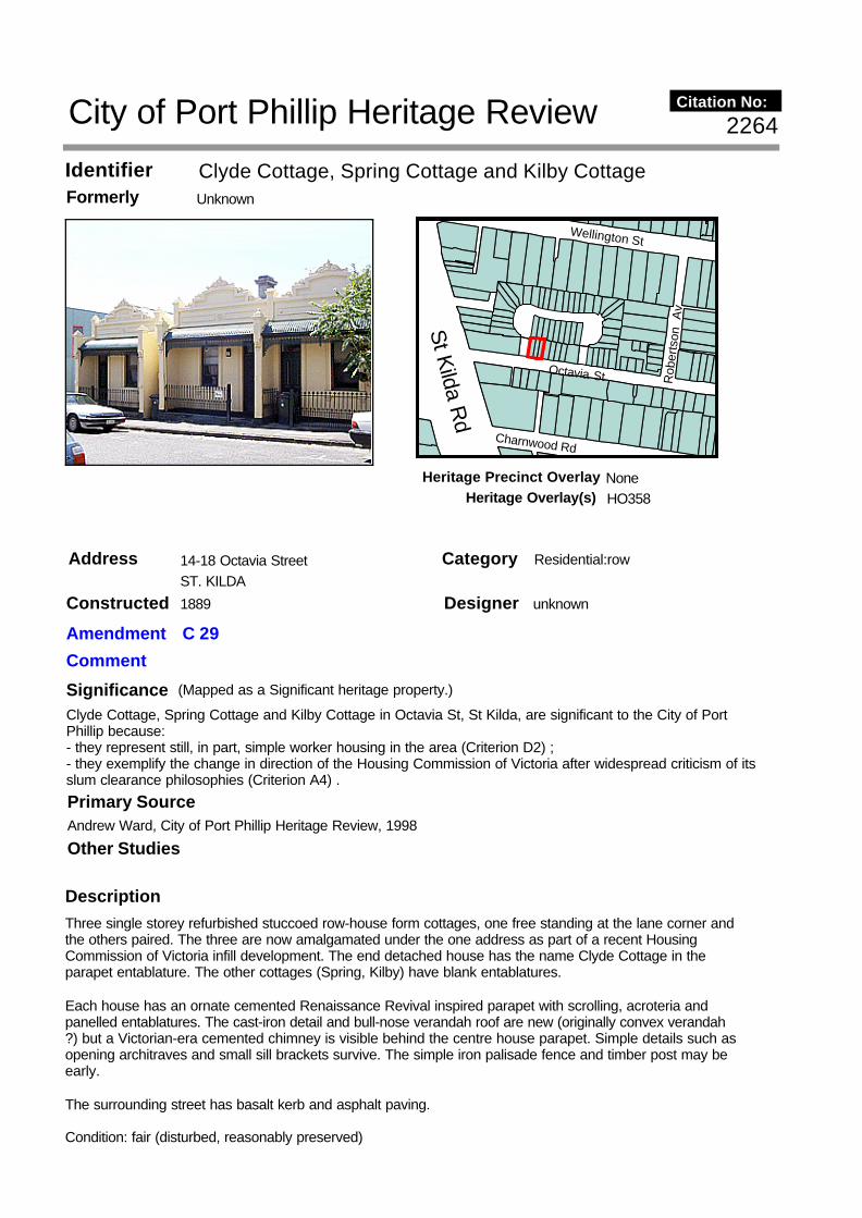
Clyde Cottage, Spring Cottage and Kilby CottageIdentifier UnknownFormerly
14-18 Octavia StreetAddress ST. KILDA
Description Three single storey refurbished stuccoed row-house form cottages, one free standing at the lane corner and the others paired. The three are now amalgamated under the one address as part of a recent Housing Commission of Victoria infill development. The end detached house has the name Clyde Cottage in the parapet entablature. The other cottages (Spring, Kilby) have blank entablatures.
Each house has an ornate cemented Renaissance Revival inspired parapet with scrolling, acroteria and panelled entablatures. The cast-iron detail and bull-nose verandah roof are new (originally convex verandah ?) but a Victorian-era cemented chimney is visible behind the centre house parapet. Simple details such as opening architraves and small sill brackets survive. The simple iron palisade fence and timber post may be early.
The surrounding street has basalt kerb and asphalt paving.
Condition: fair (disturbed, reasonably preserved)
SignificanceClyde Cottage, Spring Cottage and Kilby Cottage in Octavia St, St Kilda, are significant to the City of Port Phillip because:- they represent still, in part, simple worker housing in the area (Criterion D2) ;- they exemplify the change in direction of the Housing Commission of Victoria after widespread criticism of its slum clearance philosophies (Criterion A4) .
Designer unknown
Category Residential:row
Constructed 1889
Other Studies
Primary SourceAndrew Ward, City of Port Phillip Heritage Review, 1998
Rob
erts
on A
v
Charnwood Rd
Wellington St
Octavia St
St K
ilda Rd
2264
(Mapped as a Significant heritage property.)
City of Port Phillip Heritage Review Citation No:
Amendment C 29
Comment
NoneHeritage Precinct OverlayHeritage Overlay(s) HO358

Integrity: partially intact/intrusions
Context: Among similarly small scale housing typically of the Edwardian-era and backing onto recent HCV development set out as a court.
RecommendationsG Butler, Port Phillip Heritage Review, Version 3, 2001recommended inclusions:Schedule to the Heritage Overlay Table in the City of Port Phillip Planning Scheme
References
Longmire, A. 1989 `The Show Must Go On': 316-18 checked;VPRO Municipal Rate Book (RB), VPRS 8816/ P1 North Ward;G. Tibbits. 'The Enemy Within Our Gates'. in R. Howe, ed.' New Houses for Old', p.145;
History
Making suburbs
These houses, each brick and 3 rooms, were built in 1890 for John E and Jane Ellis by John Newton.
Occupants in Spring Cottage (16) included Henry Trewartha a mechanic, and under the ownership of James Mason and later his executors, Grace Cowan was a long term occupier around WW1. Ernest Patton of Barkly Street St Kilda was the owner when Fred Austin (metalworker), Sarah Curtayne, Keith Grant (storeman) and Charles Watt an engineer, occupied the house during the inter-war period. Henry Wishart, Joseph Ryan and Robert Duncan were early occupiers of number 14 while Fred Ball, Frank martin and Albert Illman were in number 18 during the 1890s. John Edwin Ellis himself was named as the owner and occupier of 18 around 1900 when it is assumed the house may have been empty, with a default rated person listed { RB} .
Precast reinforced concrete houses were constructed in the City for the Housing Commission of Victoria during the late 1930s-1940s as an initial experiment in precast reinforced concrete construction, following the establishment of the Housing Commission of Victoria in early 1938 { Tibbits}. Many old houses in St Kilda and South Melbourne were being purchased by the Housing commission (now the Ministry of Housing) in the 1960s-70s towards the aim of so called slum clearance or urban renewal. In 1960 the first concrete high rise Commission flats were built at the Emerald Hill estate in South Melbourne. This row was a later acquisition under policies which included retention of houses and infill rather than wholesale clearance.
Thematic Context

Beach KioskIdentifier unknownFormerly
Ormond Esplanade (at Normandy Road)
Address
ELWOOD
SignificanceWhat is Significant?The beach kiosk is a small weatherboard structure on an octagonal plan, with hipped metal roof and a surrounding verandah. It was erected by the St Kilda Council, possibly in 1921.
How is it Significant?The beach kiosk is of historical and aesthetic significance to the City of Port Phillip.
Why is it Significant?Historically, the beach kiosk is significant as the oldest surviving structure along Elwood Beach which, unlike the beaches at Port Melbourne, South Melbourne and St Kilda, did not begin to develop as a recreational facility the suburb became more settled (and accessible by public transport) in the 1910s. Possibly erected in 1921, the kiosk provides thus evidence of the earliest phase in the development of Elwood Beach as a popular recreational destination. Its ongoing operation as a refreshment kiosk right up to the present day also demonstrates a highly significant continuity of use.
Aesthetically, the kiosk is a fine and relatively intact example of a small Edwardian-style beach pavilion, of note for its distinctive octagonal form and fine decorative timberwork including turned finials and verandah with slatted frieze. One of a number of surviving pieces of early seaside recreation infrastructure along the City of Port Phillip foreshore, the kiosk remains as a prominent and distinctive element on the Elwood beach landscape.
Designer unknown
Category Public
Constructed 1921?
Other Studies
Primary SourceHeritage Alliance, Elwood Heritage Review, 2005
2337
(Mapped as a Significant heritage property.)
City of Port Phillip Heritage Review Citation No:
Amendment C 54Comment New citation
NoneHeritage Precinct OverlayHeritage Overlay(s) 426

Description The beach kiosk is a small weatherboard structure, octagonal in plan. It has a hipped roof of corrugated galvanised steel, with ogee profile guttering and a turned timber finial to the apex. The building is encircled by a verandah, with a skillion roof supported on stop-chamfered timber posts with curved timber brackets and a timber slat frieze (the latter now mostly concealed by advertising signage). The kiosk proper has three servery windows, with heavy timber sills, metal roller shutters (not original) and heavy metal bar grilles. Two of the windows have concrete steps, of relatively recent origin, to facilitate access by small children. A fourth wall has an entrance doorway, with a heavy timber threshold, plain architraves and a metal security door of recent origin.
RecommendationsRecommended inclusions:Schedule to the Heritage Overlay Table in the City of Port Phillip Planning Scheme
ReferencesJ B Cooper, A History of St Kilda, 1851 to 1931, pp 233-34.
Sands & McDougall Directory, various.
Miles Lewis (ed) Australian Architectural Index. s v Elwood Park Kiosk.
History
The small timber kiosk at Elwood can be compared with the numerous items of beach recreation infrastructure that developed along the foreshore at Port Melbourne, South Melbourne and St Kilda during the 1910s. Examples that have been previously identified in heritage studies include the octagonal bandstand at 70 Beach Street, Port Melbourne (1919), the series of gable-roofed timber beach shelters on Beaconsfield Parade, South Melbourne (c.1914), the former Pavilion Tea Rooms at 60 Jacka Boulevard, St Kilda (1916) and the St Kilda Pier Kiosk (1904) – the last, now no longer extant. The most pertinent comparison, however, can be drawn with a pair of previously unidentified timber kiosks on Jacka Boulevard, of unknown date but, on stylistic grounds, appear to be contemporaneous with the kiosk at Elwood. Virtually identical, these two structures (currently known as the Sunset Kiosk and the Boulevarde Ice Creamery Kiosk) are rectangular in plan, with stop-chamfered frames and diagonal boarding; they have distinctive bellcast roofs of corrugated galvanised steel and canted perimeter verandahs with stop-chamfered posts and slat friezes. While they are slightly larger than their polygonal counterpart in Elwood, and slightly more elaborate in their detailing, they arealso somewhat less intact, having been altered and otherwise disfigured by wall- and roof-mounted advertising hoardings.
During the nineteenth century, Elwood Beach scarcely developed as a recreational centre in the way that the adjacent beaches at St Kilda and Port Melbourne had done. By the late 1860s, the council had made some effort in planting trees and establishing a coastal promenade, but the coastline –particularly in the vicinity at Point Ormond – otherwise retained a somewhat salubrious reputation, retaining connotations with the quarantine station, manure depot and abattoirs. All three had ceased to exist by the turn of the century, followed in 1907 by the closure of the rifle butts along present-day Head Street.
In 1915, the St Kilda Council erected a refreshment kiosk on Point Ormond, to a design ‘studiously made in conformity with the buildings already erected by the St Kilda Foreshore Committee’. This substantial timber building, a conspicuous element on the point for many years, has since been demolished. The only other kiosk to be erected along the Elwood foreshore was erected by the St Kilda council in 1921 to the design of H P Brady. This first appears in the Sands & McDougall Directory in 1921, with Mrs Margaret Olingue listed as its proprietor. The wife of a local bootmaker, Mrs Olingue (1878-1968) ran the kiosk for about fifteen years. It was thence occupied by Ernest Druce (c.1936-43), B & D Passioura (1940s) and P Grieg (1950s). From the late 1950s until at least the mid-1970s, the kiosk was apparently operated by A L Crichton, listed in directories as a confectioner.
Thematic Context

City of Port Phillip Heritage Review 2348
Address Ormond Esplanade Category Public ELWOOD Constructed 1925 Designer unknown
Amendment C 54
Comment New citation
Significance (Mapped as a Significant heritage property.)
What is Significant?
The former bowling club is a simple single-storey timber-framed and fibro-clad building with a gabled roof of corrugated steel. Founded in 1925, the club closed in the 1990s and the building was converted to a community centre and café. The enclosed grounds include a detached brick storeroom of similar date, although no trace now remains of the bowling greens themselves.
How is it Significant? The former bowling club is of historical and aesthetic significance to the City of Port Phillip
Why is it Significant? Historically, the former bowling club is one of the earliest remaining buildings along the Elwood foreshore. Erected in 1925, it provides evidence of the expansion of recreational facilities along the beach during the inter-war period, and is now the only survivor amongst the complex of early twentieth-century clubhouses that included the original premises of the angling club, lifesaving club and croquet club, all of which have since been replaced by post-war buildings. More broadly, the former bowling club is also of some interest as the only one in the municipality that is located along the foreshore and, indeed, one of only four bowling clubs thus sited along the entire east coast of Port Phillip Bay.
Aesthetically, the former bowling club is significant as a distinctive element in the foreshore landscape. Although slightly altered and generally of little architectural pretension, its simple form and detailing, including strapped fibro-cement cladding with weatherboard dado, is representative of its type and era.

Primary Source Heritage Alliance, Elwood Heritage Review, 2005 Other Studies
Description
The original bowling club is a single-storeyed timber-framed building on a rectangular plan, with a broad gabled roof of corrugated galvanised steel. The exterior walls are clad with weatherboard to window sill height, with strapped cement sheeting above. The principal façade, to Ormond Esplanade, has a central double doorway (sheltered by a non-original verandah) flanked by pairs of wide timber-framed fixed-sash windows, with louvred highlights. The exposed side elevation, to the north, has similar windows, another door, and, above, a louvred vent to the gable apex. The south end of the former clubhouse has been engulfed in a substantial single-storey addition, containing the cafe; part of this echoes the form and materials of the original building, culminating in an enclosed verandah-like dining area along the south and east walls, with retractable roof, continuous bays of timber-framed casement-sash windows, and a corner entrance.
North of the clubhouse is a detached weatherboard toilet block (of recent date) and a small red brick pavilion with terracotta-tiled gambrel roof, roughcast rendered banding, weatherboard infill, louvred vents and small square windows. Its original function is unknown, but it is at least contemporary with (if not earlier than) the main building History The Elwood Bowling Club was officially opened on Saturday, 3 October 1925, when the wife of the club president, Mrs F C Smith, threw the inaugural jack and the wife of the senior vice-president, Mrs A E Watson, threw the first bowl. The ceremony was also attended by the then Mayor, Councillor Cummings, who ‘wished the club success in the ensuing season’. The new premises was one of a large number of bowling clubs whose official openings were reported in September and October of 1925, including those at Armadale, Ascot Vale, Brunswick, Camberwell, Carlton, Carrum, Collingwood, Elsternwick, Glen Iris, Ivanhoe, Kew, Middle Park, Moonee Ponds, Murrumbeena, North Fitzroy, Northcote, Sandringham, Sunshine and Thornbury.
A site plan in the Health Department’s Public Building files shows that the bowling club at Elwood occupied an allotment 189 feet (57 metres) by 184 feet (56 metres), with its timber-framed clubhouse set back 142 feet (43 metres) from Ormond Esplanade. This building, 65 feet (20 metres) by 44 feet (13 metres) in plan, contained a large clubroom with an adjacent billiard/card room, and associated facilities (office, kitchen and lavatories) along the seaward side.
The bowling club ceased in c.1991, and the former premises was subsequently converted into a council-operated community centre and café. The enclosed open space between the former clubhouse and the road, originally the bowling greens, became a children’s playground. Thematic Context
There are five lawn bowling clubs within what is now the City of Port Phillip; all are located in or beside public parks, although the former club in Elwood is the only one along the foreshore. The other clubs in the municipality are of greater vintage: St Kilda (founded 1865), Albert Park (founded 1873) and Middle Park (founded 1903). However, their built fabric varies; the clubhouse at St Kilda, for examples, includes a portion dating back to 1876 (in fact the oldest purpose-built bowling club building in Australia) and another portion added in 1927. The present Albert Park clubhouse, located within St Vincent’s Gardens, dates from as recently as 1958.
The example at Elwood must be seen in the context of the small cluster of sporting club premises that developed along the foreshore in the inter-war period: the lifesaving club (1921), the sailing club (1924), the croquet club (c.1937) and the angling club (c.1939). All of the original buildings, however, were replaced in the post-war era. Ironically, all of these clubs still remain in operation while the bowling club, which does not, is the only one that retains its original pre-war building.

Recommendations
Recommended inclusions: Schedule to the Heritage Overlay Table in the City of Port Phillip Planning Scheme References
‘Bowls’, Argus, 6 October 1925, p 6.
Public Building File No 9976, Health Department files, VPRS 7882/P1. PRO

Elwood Surf Lifesaving ClubIdentifier Elwood Beach Pavillion; Conabere PavillionFormerly
Ormond EsplanadeAddress ELWOOD
Description
SignificanceWhat is Significant?The Elwood Surf Lifesaving Club is a distinctive single-storeyed concrete block building designed in a stark and rugged Brutalist style by architect Don Hendry Fulton. Erected in 1971 on the site of a pre-war bathing pavilion, the building serves as a bathing pavilion, the premises of the local lifesaving club (established 1913) and, from 1976, the State Disaster Headquarters for all marine emergencies on Port Phillip Bay.
How is it Significant?The Elwood Surf Lifesaving Club is of aesthetic and architectural significance to the City of Port Phillip.
Why is it Significant?Aesthetically, the Elwood Surf Lifesaving Club is a fine and intact example of the so-called Brutalist style of the early 1970s, characterised by rugged and angular form, stark concrete blockwork and battered mass walls. Its unusual form, surface treatment, detailing and starkness make it a particularly distinctive element along the water’s edge. It is also the most aesthetically distinguished of the five post-war lifesaving clubs along the City of Port Phillip foreshore.Architecturally, the building is a fine, intact and particularly accessible example of the work of Don Hendry Fulton, a notable architect of the 1950s and ‘60s whose expansive practice included Olympic games infrastructure in Melbourne, a number of award-winning houses and other buildings in the suburbs and regional Victoria, and town planning projects in outback Australia.
Designer Don Hendry Fulton
Category Public
Constructed 1971
Other Studies
Primary SourceHeritage Alliance, Elwood Heritage Review, 2005
2338
(Mapped as a Significant heritage property.)
City of Port Phillip Heritage Review Citation No:
Amendment C 54Comment New citation
NoneHeritage Precinct OverlayHeritage Overlay(s) 428

The Elwood pavilion is a highly distinctive concrete block building in the stark Brutalist style. Occupying an elongated footprint along the foreshore, it comprises a row of three of gambrel-roofed volumes, linked by flat-roofed wings, with a battered base. The distinctive pavilion roofs comprise a central sawtooth element, clad inunpainted timber boards, which rises above a gently sloping hipped metal tray deck, with broad overhanging eaves. The roof of the north pavilion is raised up above the concrete block walls on a fully-glazed mezzanine level, which serves as the observation deck for the lifesaving club. This pavilion has roller shutters on the north side, but is otherwise windowless; the other two pavilions have vertical strip windows with metal-framed fixed sashes, and there are small square windows, similarly detailed, to the linking wings. Along the foreshore(west) side, the battered base incorporates several flights of steps. On the street (east) side, the main entrance is marked by a trabeated rendered portico.
RecommendationsRecommended inclusions:Schedule to the Heritage Overlay Table in the City of Port Phillip Planning Scheme
ReferencesAnne Longmire. St Kilda: The Show Goes On, p 285
History
Lifesaving clubs in what is now the City of Port Phillip were mostly formed in the 1910s, but none still occupy their original buildings. One, the Esplanade LSC, was demolished in the 1950s for the erection of the St Kilda Marina. Three others now occupy two-storey buildings of little architectural merit, dating from the 1950s and ‘60s,: South Melbourne (red brick), Middle Park (bluestone and concrete brick) and St Kilda (brick and cement sheet). The Victorian headquarters of the Surf Lifesaving Association of Australia, also on the St Kilda foreshore, is more architecturally distinguished, but in a retardataire Moderne style that was out of fashion when it built. The Port Melbourne Life Saving Clubhouse is of even more recent origin.
Aesthetically, the Elwood Pavilion is comparable to a small number of Brutalist buildings in the former City of St Kilda. Some flats at 2 Crimea Street (c.1970) are different in form but similar in their stark, windowless concrete surfaces and battered walls. The St Kilda Library at 150 Carlisle Street (1969-73) is the municipality’s finest example of the style, designed by leading practitioner Dr Enrico Taglietti. The Elwood Pavilion is also similar to the nearby soccer pavilion, off Head Street, designed by architects Young, Lehman & Co. Another stark, windowless concrete block building of rugged form (a truncated triangle with corner porches and steep roof), it is, however, much later in date (built 1980) and thus falls outside the heyday of Brutalism in the early 1970s.
Founded in 1913, the Elwood Lifesaving Club was originally based in Head Street, in a triple-fronted timber building with a central lounge flanked by dressing rooms. This was remodelled several times, including alterations in 1950 when the lounge roof was rebuilt and new toilets added. New premises were built in 1971 on the site of a sea bathing pavilion, one of three structures built by the City of St Kilda in 1928. The new Elwood Beach Pavilion, as it was known, was designed by Don Hendry Fulton. It became one of the best equipped surf lifesaving facilities in Australia; in 1976, it became the State Disaster Headquarters for all marine emergencies on Port Phillip Bay, obtaining its own water ambulance, and a control room equipped withradar and Telex facilities. More recently, the building was renamed in honour of Jack Conabere, who was a member of the lifesaving club from 1932, and its president from 1952 to 1982.
The architect, Don Hendry Fulton, completed his studies at Melbourne University in 1950 and later took a M Arch at the University of California at Berkeley. He became a highly-regarded residential architect in the 1950s, designing a house at Kew that was one of ten ‘Houses of Outstanding Merit’ selected by Architecture &Arts magazine in 1956. Fulton is best known, however, as the planner of outback mining towns such as Mary Kathleen and Weipa, also in the 1950s, and as the designer of the BP oil refinery administration building at Crib Point, which won an RAIA award in 1966. Within the City of Port Phillip, he was responsible for a distinctive cluster of mushroom-like concrete beach shelters on the Lower Esplanade at St Kilda (1967).
Thematic Context

"Beaufort"Identifier unknownFormerly
13-15 Ormond EsplanadeAddress ST. KILDA
Description Style : MediterraneanTwo storey walk-up flats
SignificanceBeaufort is a notable block of flats featuring an unusual bridged section over its central driveway. The driveway leads on to a courtyard formed by a rear wing of the flats. It is significant as an intriguingly complex example of an eclectic, Mediterranean style block. Its architecture is largely intact and is now painted an exotic post-modern pastel polychrome.
RecommendationsA Ward, Port Phillip Heritage Review, 1998recommended inclusions:Schedule to the Heritage Overlay Table in the City of Port Phillip Planning Scheme
Designer unknown
Category Residential:apartment
Constructed 1920's
Other Studies
Primary SourceRobert Peck von Hartel Trethowan, St Kilda 20th century Architectural Study Vol. 3, 1992
History
unknown
see Description
Thematic Context
Norm
andy
Rd
Bluff
Av Wilto
n Gr
Ormond Espl
749
(Mapped as a Significant heritage property.)
City of Port Phillip Heritage Review Citation No:
Amendment C 29
Comment
HO8Heritage Precinct OverlayHeritage Overlay(s)

References
unknown

FlatsIdentifier unknownFormerly
19-21 Ormond EsplanadeAddress ST. KILDA
Description Style : MediterraneanTwo storey walk-up flats
SignificanceThe single block at No 19 and the two blocks at No 21 form a strong and coherent group of two storey flats which are sited to maximise their sweeping views of the bay. As such, they are important elements in the Ormond Esplanade streetscape, expressing clearly the bayside character of its architecture. Apart from the handsome arched tapestry brick porch of the rear flats at No 21, their styling is quite simple and their impact comes mainly from their grouping. The unusual relationship of the three blocks is well resolved in their communal landscaping. Their rendered brick front fences are intact, as are the low brick fences that quaintly form the boundaries between the driveway and their gardens.
Recommendations
Designer unknown
Category Residential:apartment
Constructed late 1920s
Other Studies
Primary SourceRobert Peck von Hartel Trethowan, St Kilda 20th century Architectural Study Vol. 3, 1992
History
unknown
see Description
Thematic Context
Norm
andy
Rd
Bluff
Av
Wilton Gr
Ormond Espl
750
(Mapped as a Significant heritage property.)
City of Port Phillip Heritage Review Citation No:
Amendment C 29
Comment
HO8Heritage Precinct OverlayHeritage Overlay(s)

A Ward, Port Phillip Heritage Review, 1998recommended inclusions:Schedule to the Heritage Overlay Table in the City of Port Phillip Planning Scheme
References
unknown

"Yarramundi"Identifier unknownFormerly
27 Ormond EsplanadeAddress ST. KILDA
Description
Style : Arts and CraftsTwo storey residenceBuilder: M. SherlockOriginal owner: T.M. Davie
`Yarramundi' is a spectacular attic villa situated on the Ormond Esplanade with commanding views of Port Phillip Bay. It was designed and built for Dr T M Davie by M Sherlock in 1921. Of all the builders of St Kilda through the 1920s, Sherlock was the pre-eminent stylist. His houses are characterised by a profusion of bay windows, porches, balconies and attic dormers, executed in an exuberant eclecticism combining Arts and Crafts, Classical, and Californian Bungalow influences. "Yarramundi" is the most impressive, due mainly to its massively buttressed porch and the spectacular doric columned balcony above. Plans show it as a large family house of six bedrooms and two maids' rooms. The ground floor features the spacious porch, entrance hall and stair hall, with double doors opening into the living and dining rooms. A small office is entered through a side porch on Normandy Rd. The main room upstairs is a large billiard room which opens onto the balcony. Externally little seems to have been changed from the drawings submitted to Council for approval; the glazing to the windward side of the balcony (necessitating the removal of two pairs of columns), the only notable
SignificanceA large, complex, intact attic villa featuring a spectacular first floor balcony overlooking the Bay. Its exuberant design is the essence of Melbourne's inter-war bayside architecture, and the best on the Ormond Esplanade. It is the most prominent of a number of important and idiosyncratic works by the designer/builder, M Sherlock.
Designer M Sherlock
Category Residential:detached
Constructed 1921
Other Studies
Primary SourceRobert Peck von Hartel Trethowan, St Kilda 20th century Architectural Study Vol. 3, 1992
Norm
andy
Rd
Ormond Espl
751
(Mapped as a Significant heritage property.)
City of Port Phillip Heritage Review Citation No:
Amendment C 29
Comment
HO8Heritage Precinct OverlayHeritage Overlay(s)

exception. The eaves of the terra cotta tiled roofs feature exposed rafter ends as a ubiquitous motif, and the strutted gables are another of Sherlock's favourite devices. The gable ends and the bulkheads over the bay windows are all shingled. A small amount of ornamental exposed brick trim can still be seen, but it is hard to know how much has been lost to repainting. The current overall brilliant white, though not the original colour scheme, seems most appropriate to its maritime setting. Also intact (and white) is the elaborate brick and render fence that stretches down Normandy Rd and along the Esplanade. Its timber gate is a gem of individualistic design. The same can be said of the building itself, and the body of Sherlock's work as a whole. In "Yarramundi" he produced the most important building on the Ormond Esplanade, one that sets the scene of the seaside, bayview architecture of St Kilda.
RecommendationsA Ward, Port Phillip Heritage Review, 1998recommended inclusions:Schedule to the Heritage Overlay Table in the City of Port Phillip Planning Scheme
References
NOTESSt K C C permit No 4540.
History
unknown
see Description
Thematic Context

ResidenceIdentifier Fontainebleau Reception RoomsFormerly
31 Ormond EsplanadeAddress ST. KILDA
Description
Style : CalifornianOne storey residenceBuilder: G. SeddonOriginal owner: J. Lang
SignificanceA low slung 1920s villa notable for its excellent pergolas and port cochere. Their powerful masonry piers and heavy timber work are picked up in the original front fence. For many years from the 1950s it was run as the Fontainebleau Reception Rooms.
RecommendationsA Ward, Port Phillip Heritage Review, 1998recommended inclusions:Schedule to the Heritage Overlay Table in the City of Port Phillip Planning Scheme
Designer unknown
Category Residential:detached
Constructed 1928
Other Studies
Primary SourceRobert Peck von Hartel Trethowan, St Kilda 20th century Architectural Study Vol. 3, 1992
History
unknown
see Description
Thematic Context
Ormond Espl
Byrne
Av
Norm
andy
Rd
752
(Mapped as a Significant heritage property.)
City of Port Phillip Heritage Review Citation No:
Amendment C 29
Comment
HO8Heritage Precinct OverlayHeritage Overlay(s)

References
NOTESSt K C C permit No 7185 issued 29/5/28. Permit No U2758 issued 29/5/56 for sign and alterations for Fontainebleau Receptions.

"Ballater"Identifier unknownFormerly
39 Ormond EsplanadeAddress ST. KILDA
Description
Style : MediterraneanTwo storey residenceBuilder: W.M. Kelly Pty LtdOriginal owner: A. Atherton
Significance`Ballater' is a stately residence by the architects Blackett and Forster who were renowned for their refined Georgian Revival style buildings. `Ballaters' Mediterranean styling exhibits a similar level of finesse and proportion. The house has lost a little of its character with the removal of its windows shutters, but the front portico section in particular remains one of the most refined passages of 1920s architecture to be found in St Kilda.
Recommendations
Designer Blackett and Foster
Category Residential:detached
Constructed 1926
Other Studies
Primary SourceRobert Peck von Hartel Trethowan, St Kilda 20th century Architectural Study Vol. 3, 1992
History
unknown
see Description
Thematic Context
Tiuna
GrBy
rne A
v
Ormond Espl
753
(Mapped as a Significant heritage property.)
City of Port Phillip Heritage Review Citation No:
Amendment C 29
Comment
HO8Heritage Precinct OverlayHeritage Overlay(s)

A Ward, Port Phillip Heritage Review, 1998recommended inclusions:Schedule to the Heritage Overlay Table in the City of Port Phillip Planning Scheme
References
NOTESSt K C C permit No 6549 issued 31/8/26.

"Surf Side"Identifier unknownFormerly
46 Ormond EsplanadeAddress ST. KILDA
Description
Style : Vernacular FunctionalistThree storey walk-up flatsBuilder: C.& C. AttardOriginal owner: C.& C. Attard
SignificanceOne of St Kilda's more interesting blocks of 1960s flats, Surf Side features striking usage of contrasting brick and concrete blockwork and stepped planning with wide window bays and balconies to maximise the views across to Elwood Beach.
RecommendationsA Ward, Port Phillip Heritage Review, 1998recommended inclusions:National Estate Register
Designer unknown
Category Residential:apartment
Constructed 1960's
Other Studies
Primary SourceRobert Peck von Hartel Trethowan, St Kilda 20th century Architectural Study Vol. 3, 1992
History
unknown
see Description
Thematic Context
Bend
igo A
v
Selw
yn A
ve
Ormond Esp
Tiuna
Gr
755
(Mapped as a Significant heritage property.)
City of Port Phillip Heritage Review Citation No:
Amendment C 29
Comment
NoneHeritage Precinct OverlayHeritage Overlay(s) HO353

Schedule to the Heritage Overlay Table in the City of Port Phillip Planning Scheme
References
NOTESSt K C C permit No 2825-6 issued 23/7/63.

FlatsIdentifier unknownFormerly
51 Ormond EsplanadeAddress ST KILDA
SignificanceWhat is Significant?51 Ormond Esplanade is a three-storeyed flat-roofed rendered brick apartment building in the inter-war Functionalist style, characterised by a stark and volumetric form with fin-like brick elements, ribbon windows, and corner windows. The flats were designed in 1939 by noted local architect J H Esmond Dorney as a speculative project for his mother, Mrs M L Dorney.
How is it Significant?The flats are of aesthetic and architectural significance to the City of Port Phillip
Why is it Significant?Aesthetically, the flats are significant as a fine, relatively intact and somewhat unusual example of a large apartment block in the inter-war Functionalist style, characterised by flat roof, steel-framed corner windows, ribbon windows and a vertical emphasis. Its stark and volumetric composition is comparable to several other blocks of flats in the municipality (mostly in St Kilda), but, although slightly altered, it stands out for its unusuallybold composition and austere rendered walls (rather than the more typical face brick).
Architecturally, the former St Kiernan’s Flats are significant as one of the best examples in Elwood of the work of J H Esmond Dorney, a prolific local architect and one-time employee of Walter Burley Griffin who became a leading exponent of the Functionalist style in Melbourne in the 1930s and, after the War, a highly regarded modern architect in Tasmania.
Designer J.H. Esmond Dorney
Category Residential:apartment
Constructed 1939
Other StudiesRobert Peck von Hartel Trethowan, St Kilda 20th century Architectural Study Vol. 3, 1992 Andrew Ward, City of Port Phillip Heritage Review, 1998
Primary SourceHeritage Alliance, Elwood Heritage Review, 2005
756
(Mapped as a Significant heritage property.)
City of Port Phillip Heritage Review Citation No:
Amendment C 54Comment Updated citation
NoneHeritage Precinct OverlayHeritage Overlay(s) 424

Description 51 Ormond Esplanade comprises six flats within a stark and volumetric flat-roofed rendered brick Functionalist-style building. The triple-fronted façade, balanced but not symmetrical, has a central projecting three-storey portion, flanked by narrower wings, three and four storeys high, with disparate setbacks. The central portion is articulated by an orange brick chimney, forming a dominant vertical element, while the adjacent entry wing has a similar but narrower fin-like pier. Both have horizontal bays of steel-framed windows alongside, the former wrapping around the corner. The north wing has a vertical ribbon window to the stairwell, and two short horizontal ribbon windows at the fourth floor. The front door, shaded by a concreteslab sunhood, is set into an orange brick dado, which returns along the side of the projecting central wing and then further forward, forming a low wing wall. The partly-concealed south wing is more conventional in detail, with standard timber-framed double-hung sash windows.
RecommendationsRecommended inclusions:Schedule to the Heritage Overlay Table in the City of Port Phillip Planning Scheme
ReferencesSands & McDougall Directory, various.
City of St Kilda Building Permit No 10,942, dated 15 December 1941 [alterations]
History
As epicentres for inter-war flat development, Elwood and St Kilda are well represented by examples in the Functionalist style that was popular in the second half of the 1930s. While the idiom was characterised by a concern for pure expression of function, and a common vocabulary such as flat roofs and ribbon windows, there was still a degree of variety in local manifestations: at one end of the spectrum were those buildings (often in face brick) realised as stark volumes, and, at the other, those buildings (often rendered) in a less severe style, enlivened with curving corners or balconies and stylised ornament such as fluting, stringcourses and capping.
The St Kiernan’s Flats are an example of the former. The best examples in the municipality are those by the highly-regarded firm of Mewton & Grounds: Woy Woy at 77 Marine Parade, Elwood (1936) in rendered brick, and Bellaire at 3 Cowderoy Street, St Kilda (1936) in face brick. Another fine example in face brick is Park Court flats at 473 St Kilda Street, Elwood, by equally celebrated architects Seabrook & Fildes (1938). Lesser examples in St Kilda, by as yet unknown designers, include Burnett Lodge, 9-13 Burnett Street (c.1940), Mereen flats, 40 Burnett Street (c.1940), and High Royd flats, 36 Robe Street (1930s). All of these, however, are relatively compact, stark buildings of face brick; St Kiernan’s stands out amongst them with its particularly broad façade, its dominant vertical fin-like elements, and its smooth rendered walls.
see Description
Thematic Context

"Mabrouka"Identifier unknownFormerly
67 Ormond EsplanadeAddress ST. KILDA
Description Style : Arts and CraftsTwo storey residenceBuilder: S. CollinsOriginal owner: S. Collins
SignificanceMabrouka is a large interestingly designed and detailed 1920s residence which, apart from a coat of blue paint to its rough cast walls, appears to be very intact. Its most prominent feature is an extraordinary first floor section that is perched on doric style columns above its large curved porch to capture the views of the Bay. The front fence with its bold forms is also intact, including an original trellised section.
RecommendationsA Ward, Port Phillip Heritage Review, 1998recommended inclusions:
Designer unknown
Category Residential:detached
Constructed 1924
Other Studies
Primary SourceRobert Peck von Hartel Trethowan, St Kilda 20th century Architectural Study Vol. 3, 1992
History
unknown
see Description
Thematic Context
Vauti
er S
t
Beac
h Ave
Ormond Esp
757
(Mapped as a Significant heritage property.)
City of Port Phillip Heritage Review Citation No:
Amendment C 29
Comment
HO8Heritage Precinct OverlayHeritage Overlay(s)

Schedule to the Heritage Overlay Table in the City of Port Phillip Planning Scheme
References
NOTESSt K C C permit No 5504 issued 29/10/23.

HouseIdentifier unknownFormerly
123 Ormond EsplanadeAddress ELWOOD
Description
SignificanceWhat is Significant?The house at 123 Ormond Esplanade is a single-storey roughcast-rendered brick house in a highly unusual and distinctive Mexican hacienda style, with round arched doorways and faux projecting timber roof beams. It has a second storey addition, set well back to form a roof terrace, with a fully-glazed façade. The house was erected c.1927 for William Bleazby, a commercial traveller, whose family remained living there for almost forty years.
How is it Significant?The house is of aesthetic significance to the City of Port Phillip.
Why is it Significant?Aesthetically, the house is significant as a rare and relatively intact example of an inter-war house reminiscent of a traditional Mexican hacienda, related stylistically to the far more common Spanish Mission style that became ubiquitous in many parts of Melbourne (most notably the seaside suburbs) in the 1920s. With its volumetric composition, stark mass walling, plain archways and unusual projecting timber beams, the house stands out amongst the countless more ornate and embellished Spanish Mission houses and flats that otherwise proliferated in Elwood and St Kilda during that time. The second storey addition, although designed in a contrasting Functionalist style, is set well back and does substantially detract from the highly unusual aesthetic qualities of the original house.
Designer unknown
Category Residential:detached
Constructed 1927
Other Studies
Primary SourceHeritage Alliance, Elwood Heritage Review, 2005
2350
(Mapped as a Significant heritage property.)
City of Port Phillip Heritage Review Citation No:
Amendment C 54Comment New citation
NoneHeritage Precinct OverlayHeritage Overlay(s) 425

The house at 123 Ormond Esplanade was originally a single-storey brick inter-war house, which has been altered by a second storey addition, apparently in the post-war period. The original portion is a roughcast-rendered, flat-roofed villa in an unusual Spanish Mission style, reminiscent of a hacienda. Its double-fronted façade comprises a projecting porch to the left, with round-arched entry and side window, and a wide arched doorway within, with a pair of timber doors. Alongside is a pair of rectangular windows with multi-paned timber-framed double-hung sashes and splayed sills. The parapet line is delineated by a row of projecting timber members, intended to evoke roof beams. The side elevation has a separate entrance, set back in a recessed porch. The skillion-roofed first floor addition, set back to form a roof terrace, has a fully glazed street façade, with full-height windows and glazed doors. The side elevation, roughcast rendered to match the original house, has rectangular windows with metal framed sliding windows.
The driveway is marked by single roughcast rendered gatepost; a matching brick fence along the property linehas been demolished relatively recently.
RecommendationsRecommended inclusions:Schedule to the Heritage Overlay Table in the City of Port Phillip Planning Scheme
ReferencesSands & McDougall Directory, various.
History
While there are a considerable number of houses in Elwood (and in St Kilda) in the Spanish Mission style, these are invariably in the more ornate manifestation of that idiom, characterised by hipped rooves of Cordobatiles, solomonic (barley-twist) columns, shaped parapets and corbels, arcaded loggias, and the use of decorative wrought iron and ceramic tiling. The house at 123 Ormond Esplanade demonstrates a more understated interpretation of the style, evocative of a traditional Mexican hacienda. This is most evident in its cubic form, stark mass walling, plain arched openings, and projecting timber roof beams. This is much less common, not only in Elwood and St Kilda but also in Melbourne’s inter-war suburbs in general.
There are a few houses in East St Kilda, located at 151 Alma Road and 14 Mooltan Street, that are somewhat similar in their use of round arches and the unusual projecting roof beams, but these are otherwise more embellished than the particularly stark example at Elwood. As such, both should be considered as simplified versions of the conventional Spanish Mission idiom, rather than the extremely atypical and distinctive Mexican hacienda style that is exhibited at 123 Ormond Esplanade.
This house was evidently erected during 1927, as it first appears in the Sands & McDougall Directory in 1928. It was originally occupied by William Charles Noble Bleazby, described in electoral rolls as a commercial traveller, and his wife, Marie. Bleazby occupied the house until his relatively early death in 1945 at the age of sixty, whereupon his widow, Marie, remained there until her own death in 1964.
Thematic Context

St Bede's Church of EnglandIdentifier unknownFormerly
Cnr. Ormond Rd and Byrne AveAddress ELWOOD
SignificanceSt. Bede's church is the oldest church in Elwood and its construction reflects the intense period of building in Elwood at this time which created a new suburb. It was built as the church hall with the intention that a church would be built adjacent on the corner of Tiuna Grove.
The original building comprised the present church, but not its porch or the vestries and schoolroom at the rear. North and Williams were the Architects, James Brown the builder and the total cost was £924-14-6. Construction took place in the second half of 1916. Features of the building are the trusses, terracotta external window heads, the quoins internally and the diagonal piers.
The vicarage at number 2 Tiuna Grove was built at the end of 1917/early 1918 to the design of R.M. King. The estimated cost was £1,140, actual cost, £1,108 and the builder A.J. Bell.
A.J. Bell also built the schoolroom at the rear of the church early in 1918 at an estimated cost of £370, including lavatories along Byrne Avenue.
Vestries and guild room were added in front of the schoolroom in the latter half of 1921. E.M. Cooper was the contractor. By that time apparently the porch had been added to the church.The last major structural changes to the building were in 1929 when the original vestries within the main body of the church were removed, an organ recess added along with a new front to the building on Byrne Avenue, matching the detailing of the main porch. H.V. Frew was the Architect for these works.(David Bick, St. Kilda Conservation Study, 1985)
Designer North and Williams
Category Church
Constructed 1916
Ormond Rd
Tiuna
Gr
Glenhuntly Rd
Byrne
Ave
361
(Mapped as a Significant heritage property.)
City of Port Phillip Heritage Review Citation No:
Amendment C 29
Comment
HO8Heritage Precinct OverlayHeritage Overlay(s)

Description
Church hall and KindergartenBuilder: Cooper E H (1921)(Robert Peck Von Hartel Trethowan City of St Kilda, Twentieth Century Architectural Study, 1992)
RecommendationsA Ward, Port Phillip Heritage Review, 1998recommended inclusions:Schedule to the Heritage Overlay Table in the City of Port Phillip Planning Scheme
References
NOTESS t K C C permit No 4666 for 1921 alterations
BIBLIOGRAPHY
City of St. Kilda building permit records - Appendix
1. No. 2964 granted 16/6/1916, church building, Architects North and Williams, builder James Brown.2. No. 3431 granted 11/10/1917, vicarage, Architect R.M. King, contractor A.J.Bell.3 No.3518 granted 8/2/1918, schoolroom, builder A.J. Bell.4. No. 4666 granted 3/12/1921, guild room, vestry additions, contractor E.H. Cooper.5. No. 7618 granted 29/10/1929, various alterations, Architect H.V. Frew.
Author not known, "St. Bede 's Church, Elwood 1916-1984", unpublished, 1984, pp. 7,8 - Appendix.
Other StudiesDavid Bick in conjunction with Wilson Sayer Core Pty. Ltd., St. Kilda Conservation Study Area 2 Vol. 1, 1984
Primary SourceRobert Peck von Hartel Trethowan, St Kilda 20th century Architectural Study Vol. 3, 1992
History
unknown
see Description
Thematic Context

The AlderleyIdentifier unknownFormerly
1-13 Ormond RdAddress ELWOOD
Description
SignificanceWith its twin turreted, wedge shaped form dominating the Glenhuntly and Ormond Road intersection, `The Alderley' is of greatest significance as Elwood's most prominent and successful commercial streetscape element. It is also significant as a relatively large scale, innovative mixed use suburban development of the early 1920s. Its well articulated Arts and Crafts design is by the prominent architect Nahum Barnet. Most of its architectural features, including almost all of its shopfronts, are intact. Recent repainting and redevelopment of the streetscape around it, though of reasonably thoughtful design, detract from the building's original character.(Robert Peck Von Hartel Trethowan City of St Kilda, Twentieth Century Architectural Study,1992)
This building is a key corner element in the Elwood Junction conservation area, something of a local landmark and of interest architecturally. The design of the building, with oriel window turrets at each corner and the arcaded first floor facing Ormond Road makes it distinctive in the intersection, surrounded also by the Post Office, State Bank and the distant tower of St Columbia's church. The shopfronts are almost totally intact. The building has been unsympathetically painted.Architect Nahum Barnet designed this building for Mr Bailey and it was built at the end of 1920, construction probably extending into 1921. The design is rather conservative for its time of construction.(David Bick, St. Kilda Conservation Study, 1985)
Designer Nahum Barnet
Category Commercial: residential
Constructed 1920-1921
Other StudiesDavid Bick in conjunction with Wilson Sayer Core Pty. Ltd., St. Kilda Conservation Study Area 2 Vol. 1, 1984
Primary SourceRobert Peck von Hartel Trethowan, St Kilda 20th century Architectural Study Vol. 3, 1992
Gol
dsm
ith S
t
Ormond Rd
Bro
adw
ay
Glenhuntly Rd
Byrne
Ave
2082
(Mapped as a Significant heritage property.)
City of Port Phillip Heritage Review Citation No:
Amendment C 29
Comment
HO8Heritage Precinct OverlayHeritage Overlay(s)

Style : Federation FreestyleTwo storey shops, surgery and dwellingsBuilder: V.G. FairOriginal owner: H.E. Bailey
`The Alderley' was designed by the prominent architect Nahum Barnet as "business premises" comprising seven shops, a pharmacy and dispensary, and upstairs, a surgery suite and three two-bedroom flats. Its narrow V-shaped block at the intersection of Glenhuntly and Ormond Roads is one of the most prominent commercial sites in the City. With its two corner turrets facing the intersection, it is probably the most widely recognized architectural landmark in the Elwood area. Built in 1920-1921, it was the first of the major corner buidings of Elwood Junction, to be followed shortly by the State Bank (1922), the Maison de Luxe dance hall (1922, now demolished), the Post Office (1925) and St Columba's Church (1929). As such, it is a key element in Elwood's civic identity. The building's principal facade is its smallest, facing the junction. Its longest facade, comprised of shopfronts and rhythmic balcony openings above, stretches down Ormond Rd, forming, with the shops opposite, the major part of the "Elwood Village" shopping area. The facade continues for only some of the way along Glenhuntly Rd before breaking back to form a service yard at the rear of the shops. Apart from the corner turrets, the first floor facades are in a fairly simple Arts and Crafts style. The major window and balcony openings are slightly arched at the top, the balcony fronts curve out between intervening brick piers, and all elements are tied together with string course mouldings. The more elaborate turrets are formed above octagonal oriel window bays. Their upper panels are decorated with oval framed insets and each is topped with a bell-shaped cupola, a characteristic "landmark" device frequently found in St Kilda. The building's hipped roof is of Marseilles tiles and includes a number of skylights to light the flats and surgery. Beneath the awnings, the ground floor shopfronts feature the plate glass display windows, copper-clad beading and moulding, and leadlight upper panels typical of the shopfitting of the time. The design of the copper framing and leadlighting varies between shops; some, such as that at No.13, is particularly fine. Overall, the internal planning and general exterior styling is not especially remarkable. Nahum Barnet rose to prominence through his designs for some of Melbourne's best early 20th Century buildings, among them the Melbourne Synagogue in Toorak Rd and the former Metro Theatre at 171 Collins St. `The Alderley' is not of that class, and appears rather old-fashioned for the time it was built, but as a well sited and conceived `urban element' it is of great merit. Its success lies in Barnet's ability to exploit the site for its urban design potential, orchestrating its junction facade as a landmark and focusing its impact with the twin turrets. As the first of the ring of important buildings around the intersection, it showed imagination and vision for how the junction might develop, and its presence was no doubt a potent generating factor. Over the years it has undergone a series of superficial changes. Its current colour scheme appears to be a recent attempt to restore a more "historical" feel to it. Though pleasant enough, it is stylistically incorrect for the period of the building and does not reflect the relationship between colour, materials and forms that would have originally existed. The balconies above Ormond Rd have been glazed in and various internal alterations have been made to the shops, the dipensary room of the former pharmacy having been removed in one case. All the shopfronts are remarkably well preserved. As well as the leadlighting and the copper window framing, the timber doors with their brass fittings, the tiled thresholds and the marble doorsills are all largely intact. Only the wall tiling has been substatially changed, in some places extremely unsympathetically. The new streetscaping at the front of the corner shops has increased the perception of civic space without enhancing the character of the building.(Robert Peck Von Hartel Trethowan City of St Kilda, Twentieth Century Architectural Study, 1992)
`
RecommendationsA Ward, Port Phillip Heritage Review, 1998recommended inclusions:Schedule to the Heritage Overlay Table in the City of Port Phillip Planning Scheme
References
NOTESSt K C C permit No 4319 issued 21/9/20.
BIBLIOGRAPHY
History
unknown
see Description
Thematic Context

City of St Kilda building permit records, no. 4319 granted 21/9/1920 includes working drawings.

State BankIdentifier unknownFormerly
6 Ormond RdAddress ELWOOD
Description
Style : Free ClassicalTwo storey bank with dwellingBuilder: C.V. PittardOriginal owner: State Savings Bank of Victoria
SignificanceCULTURAL SIGNIFICANCEState Bank (previously State Savings Bank) is one of the best examples of a bank constructed during this period and is a key element in a precinct of local significance. Banks built during the First World War and the 1920's are usually in a heavy banded classicism style and this building epitomises the work of one of the two leading exponents, Architects Sydney Smith, Ogg and Serpell(2). The shopping centre at the intersection of Ormond and Glenhuntly Roads forms the heart of Elwood and has, as does the suburb generally, a building stock largely built in the first decades of this century. The State Bank is a key element in this shopping centre precinct.EXTENT OF SIGNIFICANCEFacade and rendered front section is of prime significance; the original fabric of the remainder is of secondary importance.SURROUNDING ELEMENTS OF SIGNIFICANCEPart of a precinct containing shops, post office and St. Columba's Church.(David Bick, St. Kilda Conservation Study, 1985)
Designer Sydney Smith and Ogg and Serpell
Category Commercial: residential
Constructed 1922
Other StudiesDavid Bick in conjunction with Wilson Sayer Core Pty. Ltd., St. Kilda Conservation Study Area 2 Vol. 1, 1984
Primary SourceRobert Peck von Hartel Trethowan, St Kilda 20th century Architectural Study Vol. 3, 1992
Ormond Rd
Byrne
Ave
Glenhuntly Rd
Rus
kin
St
Bro
adw
ay
Norm
andy
Rd
360
(Mapped as a Significant heritage property.)
City of Port Phillip Heritage Review Citation No:
Amendment C 29
Comment
HO8Heritage Precinct OverlayHeritage Overlay(s)

(Robert Peck Von Hartel Trethowan City of St Kilda, Twentieth Century Architectural Study, 1992)
BUILDER/ ARTISANS G,.F. Pittard(1) builder.LATER OCCUPANTSIn continuing use.LATER ADDITIONS/ ALTERATIONSBanking chamber has been gutted several times, the most recent rebuilding having just been completed. Recent bottle glass has been fitted in the residence and the interior variously redecorated. Both sections are now quite separate.DESCRIPTIONThe Elwood State Bank is a two storied building, constructed in brick with a terracotta tile roof. The front section housing the banking chamber is rendered, contrasting with the face brickwork of the residential section behind. The facade is essentially symmetrical with two 'wings' on either side of the central section with recessed first floor balcony. Features of the facade are the heavy bands, cornice parapet and squat columns. There is a projecting balcony over the front door at one end of the facade. In contrast the side walls of the front section are flat, whilst the rear section has picturesque elements such as the side gable on brackets.CONDITIONGood.ORIGINAL USEState Savings Bank.PRESENT USEContinuing use.OTHERResidence has been physically divided from the bank proper and rented out.(David Bick, St. Kilda Conservation Study, 1985)
RecommendationsA Ward, Port Phillip Heritage Review, 1998recommended inclusions:National Estate RegisterSchedule to the Heritage Overlay Table in the City of Port Phillip Planning Scheme
References
NOTESSt K C C permit No 4799 issued 20/4/22.
OTHER EVALUATIONSBruce Trethowan in "A Study of Banks In Victoria" for the (then) Historic Buildings Preservation Council - Designated List (recommended for addition to the Historic Buildings Register).
BIBLIOGRAPHY1. City of St. Kilda building permit records, no. 4799 granted 20/ /1922, includes working drawings - Appendix.
2. Bruce Trethowan, "A Study of Banks in Victoria 1851-1939", for the Historic Buildings Preservation Council, Melbourne, 1976, p.61, photo p.63
History
unknown
The State Bank was constructed in 1922 to the design of Architects Sydney Smith, Ogg and Serpell. The builder was G.F. Pittard.
Thematic Context

Flats and ShopsIdentifier unknownFormerly
15-21 Ormond RdAddress ELWOOD
Description
Style : Arts and CraftsTwo storey flats, one storey shops
SignificanceAn interesting complex of single storey shops built in front of two storey flats. For further citation see 40-42 Glenhuntly Road.
RecommendationsA Ward, Port Phillip Heritage Review, 1998recommended inclusions:Schedule to the Heritage Overlay Table in the City of Port Phillip Planning Scheme
References
Designer unknown
Category Commercial: residential
Constructed 1919-1920s
Other Studies
Primary SourceRobert Peck von Hartel Trethowan, St Kilda 20th century Architectural Study Vol. 3, 1992
History
unknown
see Description
Thematic Context
Gol
dsm
ith S
t
Ormond Rd
Byrne
Ave
Glenhuntly Rd
Norm
andy
Rd
Bro
adw
ay
760
(Mapped as a Significant heritage property.)
City of Port Phillip Heritage Review Citation No:
Amendment C 29
Comment
HO8Heritage Precinct OverlayHeritage Overlay(s)

NOTESForms part of Ormond Mansions complex 40-42 Glenhuntly Rd. May be by same architect as 13 Glenhuntly Rd.

FlatsIdentifier unknownFormerly
38 Ormond RdAddress ELWOOD
Description Style : Deco, FunctionalistTwo storey flats
SignificanceA very good quality block of 1930s flats whose picturesque stepped-back form looms impressively over its corner garden. Its wide boxed eaves give it a stylish, Prairie School character.
RecommendationsA Ward, Port Phillip Heritage Review, 1998recommended Conservation
References
NOTES
Designer unknown
Category Residential:apartment
Constructed late 1930s
Other Studies
Primary SourceRobert Peck von Hartel Trethowan, St Kilda 20th century Architectural Study Vol. 3, 1992
History
unknown
see Description
Thematic Context
Selw
yn A
veBend
igo A
v
Ormond Rd
2076
(Mapped as a Significant heritage property.)
City of Port Phillip Heritage Review Citation No:
Amendment C 29
Comment
HO8Heritage Precinct OverlayHeritage Overlay(s)

St K C C permit issued 2/3/39 for extension to bedrooms by R M & M H King, architects.(No 10207?). Permit No. 10046 issued 16/8/38 for earlier alterations. Stylistically this building appears to have possibly been designed by J.H. Esmond Dorney, though no documentary evidence to that effect has been found.

"Surrey Court" FlatsIdentifier unknownFormerly
71 Ormond RdAddress ELWOOD
SignificanceSurrey Court is a large, picturesque Old English style block of flats by the architect J. Esmond Dorney, who designed several of Elwood's most interesting blocks of flats in the 1930s. Its fully enclosed courtyard plan (entered through tunnel-like carriageways at front and rear) is an extremely rare format, and unique in St Kilda. Surrey Court features a profusion of Old English architectural elements and decorative treatments, applied in a relatively unco-ordinated manner. Together with the courtyard and carriageway format, though, they combine to make a building of great visual appeal and local prominence. The almost theatrical application of its medieval motifs is illustrative of the historical imagery that was still demanded of fashionably respectable flats in the 1930s, and is thus also indicative of Elwood's respectability as a residential suburb at this stage of its development. The building is still highly intact, and its immaculate courtyard and small front gardens contribute to its style and character.(Robert Peck Von Hartel Trethowan City of St Kilda, Twentieth Century Architectural Study,1992)
Surrey Court is a distinctive block of flats in an Elizabethan/Tudor style, of note for its arrangement around a central courtyard and is a local landmark. Comparison with the more affluent Hartpury Court in Milton Street (q. v.) shows clearly the nature of this design, which relies on varied detailing and the courtyard arrangement to give the period effect to what is otherwise a plain building mass. The clipped hedges enhance the building.Surrey Court Pty. Ltd. built the flats to the design of Architect J.H. Esmond Dorney in the latter half of 1933. Dorney designed a number of blocks of flats in St. Kilda and Elwood at this time.(David Bick, St. Kilda Conservation Study, 1985)
Designer J.H. Esmond Dorney
Category Residential:apartment
Constructed 1933
Ormond Rd
Beac
h A
ve
Selw
yn A
ve
362
(Mapped as a Significant heritage property.)
City of Port Phillip Heritage Review Citation No:
Amendment C 29
Comment
NoneHeritage Precinct OverlayHeritage Overlay(s) HO220

Description
Style : Old EnglishTwo storey walk-up flatsOriginal owner: Surrey Court Pty Ltd
'Surrey Court' is a large two storey flat development in a mock-Tudor style based around a central courtyard. Its courtyard format appears to be unique in St Kilda: a central driveway passes through it on axis, entering from Ormond Rd through a Tudor-arched undercroft and exiting at the far end through a similar undercroft to garages at the rear. Apart from the tunnel-like access points, the courtyard is completely enclosed on all four sides. The complex was designed by the local architect J.H.Esmond Dorney in 1933 for Surrey Court Pty Ltd, most likely as a speculative rental venture. Dorney's work in the Elwood area through the 1930s displays an extraordinary spectrum of fashionable styles, from Surrey Court's Old English pastiche through to the stark Modernist geometry of 51 Ormond Esplanade (q.v.). Architecturally, Surrey Court is not his finest piece. Except for the overall courtyard format, its planning and massing is relatively ordinary. It relies mainly on the superficial application of motifs for its Old English effect rather than a more deeply integrated design approach. The motifs themselves are accordingly somewhat disparate and uncoordinated. (Compare the far stronger, and earlier, Old English style flats by the architect Arthur W. Plaisted: `Hampden', 74 Barkly St (1919), and `Hartpury Court', 11 Milton St (1923).) Nevertheless, as an elaborate piece of almost theatrical flat design it is of considerable historical interest, local prominence and visual appeal. Its orchestrated Old World charm, evidently aimed at a niche towards the prestigious end of the rental market, is an exemplary illustration of the historical imagery still demanded for fashionable flat developments of the time, and reflects Elwood's continuing status as a respectable dormitory suburb. It is one of Elwood's best known buildings: set close to the front property line, its multi-gabled facade commands a strong and evocative presence on Ormond Rd, and its archway offers every passer-by an irresistible peep into its charming and immaculately kept courtyard garden.There is a remarkable degree of variance between the architect's drawings as submitted to the St Kilda Council and the building design as built, which suggests a certain arbitrariness in the final arrangement of its Old English motifs. While the basic planning appears to have remained fixed, important elements, such as the roof form, were re-designed quite radically.(The original design had no gables). The building's most prominent feature, the half-timbered first floor gabled sections above the arched carriageways, do not appear on the drawings, and were apparently an inspired afterthought. Indeed the drawings show only the western half of the block (with the arched connections awaiting the eastern half) indicating that perhaps the building was completed in stages. The "Tudor" themes established from the start include the cantilevering of the first floor several inches beyond the ground floor walls, the contrasting materials of the wall surfaces (clinker brick for the ground floor, rendered upper floors, and occasional sandstone accents), and the picturesquely stepped brick chimneys. Other thematic elements in the ensemble include corbelled oriel windows, diamond paned glazing, the jerkinhead gables of the southwest corner, the heavy timber barges of many of the gables, and a plethora of small, tiled awnings, porches and roof fragments. The most deeply embedded medieval allusion in the design is, of course, the enclosed courtyard format. In the original plans, all but the two upstairs front flats are accessed from the courtyard, reminiscent of the balconied compounds of the inns of Tudor England. (The downstairs front flats now have entries to the street too.) The drawings show one two bedroom and two one bedroom flats on each floor, making twelve in all when duplicated in the eastern half. A slightly later plan shows a small one bedroom flat inserted into the roof space at the rear.
Assessment of the overall intactness of the building is difficult to make, due to the discrepancy between the plans and the existing building. For example, the drawings show window boxes fitted on corbelled brackets under the triple-bayed windows. The brackets were built, but whether the boxes were subsequently removed or simply never installed is not known. (The window openings look rather too small and bare without them.) The two front chimneys raise a similar question: above the eaves line one is painted and the other not; below, both chimney backs are painted. A more detailed inspection is needed to establish their original state. In general appearance, though, the building seems to be highly intact. The landscaping, which so enhances the building's architecture with its neatly clipped hedges in the courtyard and behind the low brick front fence, seems very much as originally intended.(Robert Peck Von Hartel Trethowan City of St Kilda, Twentieth Century Architectural Study, 1992)
Other StudiesDavid Bick in conjunction with Wilson Sayer Core Pty. Ltd., St. Kilda Conservation Study Area 2 Vol. 1, 1984
Primary SourceRobert Peck von Hartel Trethowan, St Kilda 20th century Architectural Study Vol. 3, 1992

RecommendationsA Ward, Port Phillip Heritage Review, 1998recommended inclusions:Schedule to the Heritage Overlay Table in the City of Port Phillip Planning Scheme
References
NOTESSt K C C permit No 8290 issued 23/6/33. Permit No 8362 issued 2/10/33 for extra flat.
BIBLIOGRAPHYCity of St. Kilda building permit records, no. 8290 granted 23/6/1933, includesworking drawing.
History
unknown
see Description
Thematic Context

DuplexIdentifier unknownFormerly
73-75 Ormond RdAddress ELWOOD
Description Style : Arts and CraftsTwo storey duplex
SignificanceAn unusual and interestingly designed two storey duplex in a neatly preserved state. It features two charming upstairs balcony sunrooms. Above each corner sunroom window, defying any obvious explanation of function, is perched an ornamental chimney stack. A distinctive, pleasing and somewhat puzzling design.
RecommendationsA Ward, Port Phillip Heritage Review, 1998recommended Conservation
References
Designer unknown
Category Residential:attached
Constructed late 1910s
Other Studies
Primary SourceRobert Peck von Hartel Trethowan, St Kilda 20th century Architectural Study Vol. 3, 1992
History
unknown
see Description
Thematic Context
Ormond Rd
Beac
h Ave
Selw
yn A
ve
764City of Port Phillip Heritage Review Citation No:
Amendment C 29
Comment
NoneHeritage Precinct OverlayHeritage Overlay(s)

unknown

John Barker ChemistIdentifier Chemist ShopFormerly
90 Ormond RdAddress ELWOOD
Description
Style :FreestyleTwo storey shopBuilder: W.T.Thickbroom (1913)
SignificanceCULTURAL SIGNIFICANCEFormer chemist shop is an important shop building from this period in design and is also distinctive for the stone - faced ground floor walls. This building illustrates the transition from the Art Nouveau influenced Edwardian period to architecture of the 1920's and is an important work of Architects North and Williams. Stone was very rarely used for shops during the 20th century. The evolution of this building, the shop area only having been built in 1913(1), with the extensive alterations and additions of rear residence and first floor in 1917(2), reflects the rapid development of Elwood around the First World War. Notable features externally include the main facade parapet and verandah. Internally the stair well and the chimney breast in the main private room on the ground floor are significant.EXTENT OF SIGNIFICANCEEntire building.SURROUNDING ELEMENTS OF SIGNIFICANCENone. Surrounded by shops built in the same period, which give a clear indication of the norm for shop design during this period. Part of the Ormond Road conservation area.(David Bick, St. Kilda Conservation Study, 1985)
Designer North and Williams
Category Commercial
Constructed 1913-1917
Other StudiesDavid Bick in conjunction with Wilson Sayer Core Pty. Ltd., St. Kilda Conservation Study Area 2 Vol. 1, 1984
Primary SourceRobert Peck von Hartel Trethowan, St Kilda 20th century Architectural Study Vol. 3, 1992
Dock
er St
Vauti
er St
Ormond Rd
Beac
h Ave
766
(Mapped as a Significant heritage property.)
City of Port Phillip Heritage Review Citation No:
Amendment C 29
Comment
NoneHeritage Precinct OverlayHeritage Overlay(s) HO221

Original owner: H.M. Barker(Robert Peck Von Hartel Trethowan City of St Kilda, Twentieth Century Architectural Study, 1992)
DATE OF CONSTRUCTION1917(2) (oldest section 1913(1)ORIGINAL OWNERH.M. Barker(2),(3).BUILDER/ ARTISANS1917 not known. 1913 W.T. Thickbroom(1).LATER ADDITIONS/ ALTERATIONSLater alterations have been minor. The first floor balcony has been glazed and minor alterations and redecoration undertaken internally. All old shop fittings, have been removed. The present external paint colour to the first floor is too strong; it is not clear if the building was originally painted to this extent.DESCRIPTIONThe former chemist shop is a two storey brick building, with a Waurn Ponds stone Western wall on a bluestone plinth and Stawell stone shopfront piers(2). The north (Ormond Road) facade parapet appears also to be stone, as it is exfoliating, the paint makes it difficult to tell. The shop verandah has a pressed metal sheet ceiling. The side entrance gives access to the stair well. The leadlight windows, timber arch and the stair itself are features. The exposed brick chimney breast in the main private room downstairs is unusual. The glazed, first floor doors and the small verandah overlooking Ormond Road are features on the upper floor.CONDITIONThis building is in good condition.ORIGINAL USEPharmacy.PRESENT USECommercial premises - occupants Jacarandah Wiley Ltd.INTACTNESSAny shop fittings have been removed, but otherwise the building is intact, externally and internally. The first floor balcony has been glazed and the name of the current tenants has been inserted into the central leadlight shop window, the side panels being original. Minor changes have been made internally.(David Bick, St. Kilda Conservation Study, 1985)
RecommendationsA Ward, Port Phillip Heritage Review, 1998recommended inclusions:Victorian Heritage RegisterNational Estate RegisterSchedule to the Heritage Overlay Table in the City of Port Phillip Planning Scheme
References
BIBLIOGRAPHY
City of St. Kilda building permit records1. No. 2032 granted 1/10/1913, includes working drawing - Appendix.
2. No. 3266 granted 1/16/1917, includes working drawings - Appendix.
3. City of St. Kilda Rate Books, various years.
History
unknown
H.M. Barker had a 24 foot square brick shop erected by builder W.T. Thickbroom in 1913(1). This first building is the shop area of the present building. In 1917 Barker commissioned Architects North and Williams to extensively alter and enlarge the existing building(2). This work involved knocking the old shop into one large room, constructing a stair well and rear rooms behind it and a first floor over both sections. The first building was refaced in stone to match the new work. The estimated cost of this work was £11,350(2).(David Bick, St. Kilda Conservation Study, 1985)
Thematic Context
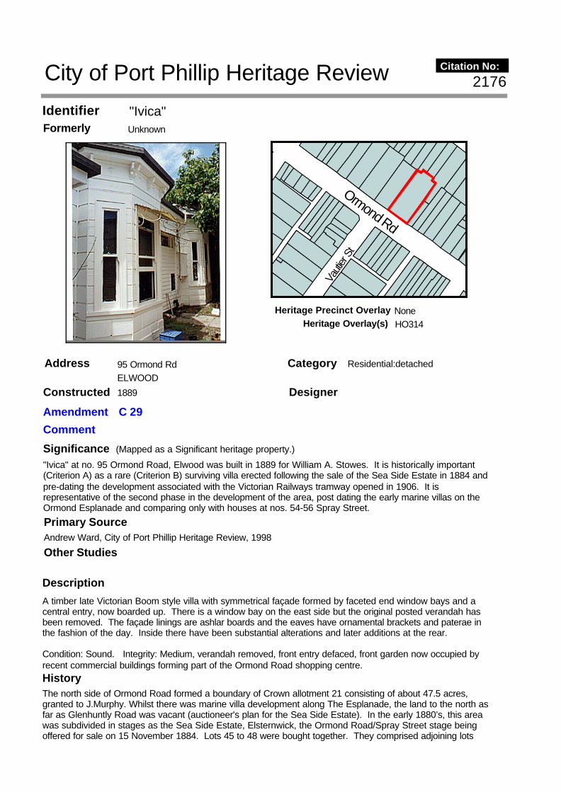
"Ivica"Identifier UnknownFormerly
95 Ormond RdAddress ELWOOD
Description
A timber late Victorian Boom style villa with symmetrical façade formed by faceted end window bays and a central entry, now boarded up. There is a window bay on the east side but the original posted verandah has been removed. The façade linings are ashlar boards and the eaves have ornamental brackets and paterae in the fashion of the day. Inside there have been substantial alterations and later additions at the rear.
Condition: Sound. Integrity: Medium, verandah removed, front entry defaced, front garden now occupied by recent commercial buildings forming part of the Ormond Road shopping centre.
Significance"Ivica" at no. 95 Ormond Road, Elwood was built in 1889 for William A. Stowes. It is historically important (Criterion A) as a rare (Criterion B) surviving villa erected following the sale of the Sea Side Estate in 1884 and pre-dating the development associated with the Victorian Railways tramway opened in 1906. It is representative of the second phase in the development of the area, post dating the early marine villas on the Ormond Esplanade and comparing only with houses at nos. 54-56 Spray Street.
Designer
Category Residential:detached
Constructed 1889
Other Studies
Primary SourceAndrew Ward, City of Port Phillip Heritage Review, 1998
History The north side of Ormond Road formed a boundary of Crown allotment 21 consisting of about 47.5 acres, granted to J.Murphy. Whilst there was marine villa development along The Esplanade, the land to the north as far as Glenhuntly Road was vacant (auctioneer's plan for the Sea Side Estate). In the early 1880’s, this area was subdivided in stages as the Sea Side Estate, Elsternwick, the Ormond Road/Spray Street stage being offered for sale on 15 November 1884. Lots 45 to 48 were bought together. They comprised adjoining lots
Vauti
er St
Ormond Rd
2176
(Mapped as a Significant heritage property.)
City of Port Phillip Heritage Review Citation No:
Amendment C 29
Comment
NoneHeritage Precinct OverlayHeritage Overlay(s) HO314

RecommendationsA Ward, Port Phillip Heritage Review, 1998recommended inclusions:Schedule to the Heritage Overlay Table in the City of Port Phillip Planning Scheme
References
St.Kilda Rate Books: 1886-91, 1899-1900. VPRS 2335, PROV.MMBW litho plan no.84, undated.Parish plan, Prahran. SLV, Map Section, St.Kilda and Elwood, 820 bje.Sea Side Estate, Elsternwick, 15 November 1884. SLV Vale Collection Book 6.
4. Building settlements, towns and cities: 4.1.2. Making suburbs (Elwood).
45 and 48 in Ormond Road which backed onto lots 46 and 47 on the south side of Spray Street. Each lot had a frontage of 66 feet. In 1886 they were owned by the accountant and stockbroker, James Blackmore McQuie of “Walton” in Elm Avenue.
In 1887, the “gentleman” William A.Stowes bought the Ormond Road lots and between 1888 and 1889 built a house there for his residence. It was described as “wood etc, eight rooms, NAV 70 pounds”. In 1891, Annie Hughes bought the property from Stowes and the vacant lots in Spray Street from George Watts. By the turn of the century, the house had been acquired by P.Perlstein of Exhibition Street, Melbourne. He leased it to the “gentleman” Gerald Branson.
The first MMBW plan of the area showed the house at no.95 with a wide return verandah extending across the front of the house and a substantial addition to the east side that may have been a conservatory. Large timber stables were at the rear of the house which at that time was known as “Ivica”.
Thematic Context

Shop and DwellingIdentifier unknownFormerly
121 Ormond RdAddress ELWOOD
Description
Style : Arts and CraftsTwo storey shop and dwellingBuilder: J.S. WearneOriginal owner: T.C. Wood(Robert Peck Von Hartel Trethowan City of St Kilda, Twentieth Century Architectural Study, 1992)
SignificanceCULTURAL SIGNIFICANCEShop at 121 Ormond Road, Elwood, is an intact shop building of unusual design built during the First World War. First floor verandahs were a common feature of two storey shops built during the 1910's and 1920's, but usually they were set behind a front wall. In this building the verandah is roofed by a lean-to tile roof with a central gable on paired timber posts. The shopfront is intact; no shop fittings remain. The remainder of the building is intact and the joinery, architraves and so on have not been painted, which is uncommon. Projecting bay windows and half-timbered bathroom are features of the side elevation, where the entry to the residence is located.EXTENT OF SIGNIFICANCE Entire building.SURROUNDING ELEMENTS OF SIGNIFICANCENeighbouring shops were built during the same period. Part of the Ormond Road conservation area.(David Bick, St. Kilda Conservation Study, 1985)
Designer W.H. Smith
Category Commercial: residential
Constructed 1915
Other StudiesDavid Bick in conjunction with Wilson Sayer Core Pty. Ltd., St. Kilda Conservation Study Area 2 Vol. 1, 1984
Primary SourceRobert Peck von Hartel Trethowan, St Kilda 20th century Architectural Study Vol. 3, 1992
Vauti
er S
t
Ormond Rd
Dock
er S
t
364
(Mapped as a Significant heritage property.)
City of Port Phillip Heritage Review Citation No:
Amendment C 29
Comment
HO8Heritage Precinct OverlayHeritage Overlay(s)

DATE OF CONSTRUCTION1915 (1),(2)ORIGINAL OWNERT.C. Wood (1)ARCHITECTW. H. Smith (1)BUILDER/ARTISANSJ.S. Wearne builder (1)LATER OCCUPANTS1915 - 1923/24 Richard Gilbert; 1923/24 - 1927/28 Robert Ferguson and Harold Lawrence; 1927/28 - Second World War at least, Eliza May Muir.DESCRIPTIONThis shop and dwelling is a two storey, red face brick building with a terracotta tile roof. Windows are timber and half timbering is used to the gable and projecting bathroom. The shopfront is light metal framed, unpainted, with a tile stallboard.CONDITIONThis building is in good condition.ORIGINAL USEGrocer's shopPRESENT USELeadlight shop.INTACTNESS The building is intact. The first floor verandah balustrade has been painted white.(David Bick, St. Kilda Conservation Study, 1985)
RecommendationsA Ward, Port Phillip Heritage Review, 1998recommended inclusions:Schedule to the Heritage Overlay Table in the City of Port Phillip Planning Scheme
References
NOTESSt K C C permit No 2714 issued 27/8/15.
BIBLIOGRAPHY1. City of St. Kilda building permit records, no. 1714 granted 27/8/1915, includes working drawing - Appendix.2. City of St. Kilda Rate Books, various years; 1915/16 no. 6439 South Ward, “…. being erected…”
History
unknown
Architect W.H. Smith designed this shop and dwelling for T.C. Wood. J. S. Wearne constructed the building in 1915 at an estimated cost of £1,190. The first occupants were grocers, Richard Gilbert from 1915 to c. 1923/24. Robert Ferguson and Harold Lawrence succeeded him. In 1927/28 Eliza May Muir, a costumier or dressmaker, took over the shop and held it till at least the Second World War.
(David Bick, St. Kilda Conservation Study, 1985)
Thematic Context

Elwood Reception RoomsIdentifier The Broadway Theatre (former Cinema)Formerly
145-149 Ormond RdAddress ELWOOD
Description Style : Free ClassicalPublic hall, former cinemaBuilder: R.G. McCartneyOriginal owner: R.G. McCartney
SignificanceFormerly the Broadway Theatre this hall has been a prominent social venue since it was opened in c. 1920. It was built and redecorated in a number of stages. Architecturally it is most notable for its exquisite and elaborately detailed neo-classical plaster work on its first floor facade. Its ground floor frontage is now in a very poor state. The interior should be investigated.
RecommendationsA Ward, Port Phillip Heritage Review, 1998recommended inclusions:
Designer unknown
Category Commercial
Constructed 1919-1933
Other Studies
Primary SourceRobert Peck von Hartel Trethowan, St Kilda 20th century Architectural Study Vol. 3, 1992
History
unknown
see Description
Thematic Context
Spray St
Dock
er St
Pine A
ve
Ormond Rd
768
(Mapped as a Significant heritage property.)
City of Port Phillip Heritage Review Citation No:
Amendment C 29
Comment
HO8Heritage Precinct OverlayHeritage Overlay(s)

Schedule to the Heritage Overlay Table in the City of Port Phillip Planning Scheme
References
NOTESSt K C C permit No 3881 issued 16/5/19. Permit No 7704 issued 1930 for new roof structure and ceiling.

Shops and DwellingsIdentifier unknownFormerly
151-155 Ormond RdAddress ELWOOD
Description
Style : Free StyleTwo storey shops and dwellings
SignificanceThree shops with dwellings above whose well-preserved first floor facades match Nos 161 - 167 (q.v.), forming an important streetscape of repeating elements. The contrast between brickwork (still unpainted) and rendered surfaces, along with the expression of party walls as rusticated piers, contribute to the visual quality of the group. Some original shop front elements remain, particularly in the recent stylish renovation to No. 155.
RecommendationsA Ward, Port Phillip Heritage Review, 1998recommended Conservation A Ward, Port Phillip Heritage Review, 1998recommended inclusions:Schedule to the Heritage Overlay Table in the City of Port Phillip Planning Scheme
Designer unknown
Category Commercial: residential
Constructed 1922?
Other Studies
Primary SourceRobert Peck von Hartel Trethowan, St Kilda 20th century Architectural Study Vol. 3, 1992
History
unknown
see Description
Thematic Context
Spray St
Dock
er St
Pine A
ve
Ormond Rd
769
(Mapped as a Significant heritage property.)
City of Port Phillip Heritage Review Citation No:
Amendment C 29
Comment
HO8Heritage Precinct OverlayHeritage Overlay(s)

References
unknown

Concrete Shops (Shops & Dwellings)Identifier unknownFormerly
157-159 Ormond RdAddress ELWOOD
Description
Style : Federation Arts and CraftsTwo storey shops and dwellingsBuilder: Fibro Construction Co.Original owner: M. Harris
SignificanceThese two shops are unusual and possibly of importance for their concrete construction. Concrete buildings were occasionally constructed at this time, but not often. Consequently these two shops may be the only concrete shops built in Victoria from this, or any period. Until a comprehensive survey of such buildings is undertaken throughout the State, this cannot be determined.The concrete construction extends to the first floor bay windows.Mrs. N. Harris commissioned the building, designed by John Marshall, Engineer.(David Bick, St. Kilda Conservation Study, 1985)
Designer Engineer: John Marshall
Category Commercial
Constructed 1920
Other StudiesDavid Bick in conjunction with Wilson Sayer Core Pty. Ltd., St. Kilda Conservation Study Area 2 Vol. 1, 1984
Primary SourceRobert Peck von Hartel Trethowan, St Kilda 20th century Architectural Study Vol. 3, 1992
History
unknown
see Description
Thematic Context
Pine A
ve
Ormond Rd
365
(Mapped as a Significant heritage property.)
City of Port Phillip Heritage Review Citation No:
Amendment C 29
Comment
HO8Heritage Precinct OverlayHeritage Overlay(s)

RecommendationsA Ward, Port Phillip Heritage Review, 1998recommended inclusions:Schedule to the Heritage Overlay Table in the City of Port Phillip Planning Scheme
References
NOTESSt K C C permit No 4099 issued 16/3/20.
BIBLIOGRAPHYCity of St. Kilda building permit records, no. 4098 granted in March, 1920.

Shops and DwellingsIdentifier unknownFormerly
161-169 Ormond RdAddress ELWOOD
Description Style : Free StyleTwo storey shops and dwellingsOriginal owner: H.& W. Gattlin
SignificanceFour shops with dwellings above, whose distinctive first floor facades match Nos 151-155 (q.v.), forming an important streetscape. The facades are generally intact with only a few rendered surfaces painted.
RecommendationsA Ward, Port Phillip Heritage Review, 1998recommended inclusions:Schedule to the Heritage Overlay Table in the City of Port Phillip Planning Scheme
Designer unknown
Category Commercial: residential
Constructed 1922
Other Studies
Primary SourceRobert Peck von Hartel Trethowan, St Kilda 20th century Architectural Study Vol. 3, 1992
History
unknown
see Description
Thematic Context
Foam
St
Spray St
Dock
er St
Ormond Rd
Pine
Ave
771
(Mapped as a Significant heritage property.)
City of Port Phillip Heritage Review Citation No:
Amendment C 29
Comment
HO8Heritage Precinct OverlayHeritage Overlay(s)

References
NOTESSt K C C permit No 5041.

"Hatton"Identifier unknownFormerly
173 Ormond RdAddress ELWOOD
Description Style : MediterraneanOne storey residenceBuilder: Alexander MillerOriginal owner: Alexander Miller
SignificanceA house built by the prominent local builder Alexander Miller for himself in the mid 1920s. His son, who carried on the business, still lives there, and the house has remained intact throughout its life. Its most notable feature is its extremely unusual and intact coloured spackled render which is found in St Kilda only on a few Miller-built buildings.
RecommendationsA Ward, Port Phillip Heritage Review, 1998recommended inclusions:
Designer unknown
Category Residential:detached
Constructed mid 1920s
Other Studies
Primary SourceRobert Peck von Hartel Trethowan, St Kilda 20th century Architectural Study Vol. 3, 1992
History
unknown
see Description
Thematic Context
Pine A
ve
Spray St
Foam
St
Ormond Rd
772
(Mapped as a Significant heritage property.)
City of Port Phillip Heritage Review Citation No:
Amendment C 29
Comment
HO8Heritage Precinct OverlayHeritage Overlay(s)

Schedule to the Heritage Overlay Table in the City of Port Phillip Planning Scheme
References
NOTESSt K C C permit No 8194A. Miller built many houses and flats in St Kilda incl. on The Esplanade south of Robe St, and in Wimbledon Ave.

ResidenceIdentifier unknownFormerly
77 Ormond RdAddress ST. KILDA
Description
Style : MediterraneanTwo storey residence and surgeryOriginal owner: F.T. Herbert
SignificanceA well proportioned and detailed two storey residence featuring an attractive columned porch on both floors and a self-contained surgery in a small wing to the south. It is most notable for its highly unusual splayed plan form which sets up a number of interesting and deftly handled spatial relationships both inside and out.
RecommendationsA Ward, Port Phillip Heritage Review, 1998recommended inclusions:Schedule to the Heritage Overlay Table in the City of Port Phillip Planning Scheme
Designer F.J. Davies
Category Commercial: residential
Constructed 1923
Other Studies
Primary SourceRobert Peck von Hartel Trethowan, St Kilda 20th century Architectural Study Vol. 3, 1992
History
unknown
see Description
Thematic Context
Ormond Rd
Beac
h Ave
765
(Mapped as a Significant heritage property.)
City of Port Phillip Heritage Review Citation No:
Amendment C 29
Comment
NoneHeritage Precinct OverlayHeritage Overlay(s) HO303

References
NOTESSt K C C permit No 5076 issued Nov 1922.

"Avalon"Identifier unknownFormerly
285 Orrong RdAddress ST. KILDA EAST
Description Style : Arts and CraftsAttic villa
SignificanceA solid attic villa typical of the style of the better 1920s homes of the area. The contrasting bay window forms and the easy swag of the verandah balustrade on the front elevation give the home a well balanced though asymmetrical form. The home sits prominently on its corner site. The intact low wall fence and privet hedge and its side elevation contribute to the important street frontage on Wenden Grove.
RecommendationsA Ward, Port Phillip Heritage Review, 1998recommended inclusions:Schedule to the Heritage Overlay Table in the City of Port Phillip Planning Scheme
Designer unknown
Category Residential:detached
Constructed 1925
Other Studies
Primary SourceRobert Peck von Hartel Trethowan, St Kilda 20th century Architectural Study Vol. 3, 1992
History
unknown
see Description
Thematic Context
WendenGr
Mon
tagu
e S
t
Orr
ong
Rd
Eas
tM
arne
St
Nottage St
Inkerman St
773
(Mapped as a Significant heritage property.)
City of Port Phillip Heritage Review Citation No:
Amendment C 29
Comment
NoneHeritage Precinct OverlayHeritage Overlay(s) HO222

References
NOTESSt K C C permit No 6007.

HouseIdentifier unknownFormerly
311 Orrong RdAddress ST. KILDA EAST
Description
A picturesque Arts and Crafts influenced Californian Bungalow distinguished by its tapered river stone pillars, angled chimney at the main gable apex, flat roofed porch extended across the face of the gable end and double hung windows with glazing bars in the upper sashes strongly suggestive of Japanese influence. There is a terra cotta tiled roof, vented gablet, rough cast walls and slotted gable end vents as contributory stylistic elements. Condition: Sound. Integrity: High, included front fence.
SignificanceThe Bungalow at no. 311 Orrong Road, St. Kilda East, was built in 1920 for Mrs. Lilian Rubens. It is aesthetically important (Criterion E) as a substantially intact Californian Bungalow demonstrating both Arts and Crafts and Japanese influence in a distinctive way and recalling the work of internationally celebrated architect, Frank Lloyd Wright, over a decade earlier. It is very similar to the house at no. 217 Alma Road, St. Kilda East.
Designer unknown
Category Residential:detached
Constructed 1920
Other StudiesRobert Peck von Hartel Trethowan, St Kilda 20th century Architectural Study Vol. 3, 1992
Primary SourceAndrew Ward, City of Port Phillip Heritage Review, 1998
History At the turn of the century, Judge, Sir Edward Holroyd, owned a large property on the south side of Alma Road between Lansdowne and Orrong Roads. It was known as Fern Leaves and comprised a brick house with 16 rooms and 5 acres of land.
The land was subdivided c.1917 resulting in the formation of Holroyd and Dean Avenues and the subdivision of the land between these two avenues on the west side of Orrong Road. Lot 44, with a frontage of 51 feet, was purchased by J.C.Machin in 1917. Machin sold the land to Lewis Levy in 1918. Levy in turn sold it to Mrs.Lilian Rubens in 1919. At the time, the land had an NAV of 15 pounds.
Alma Rd
Hughenden Rd
Orr
ong
R
d
46
(Mapped as a Significant heritage property.)
City of Port Phillip Heritage Review Citation No:
Amendment C 29
Comment
NoneHeritage Precinct OverlayHeritage Overlay(s) HO223

RecommendationsRecommended for inclusion in the Schedule to the Heritage Overlay Table in the City of Port Phillip Planning Scheme.
References
St. Kilda Rate Books: 1915-21, 1925-26, 1935-36. VPRS 8816/P1, PROV.Sands and McDougall Directories: 1900, 1916.MMBW litho plan no.47, dated 1935.
4. Building settlements, towns and cities. 4.1.2 Making suburbs.
In 1920, Mrs.Rubens built a six roomed brick house on the site which she leased to Douglas Reid, a gentleman. The NAV was 80 pounds.
By 1926, Oswald Benjamin, a public accountant, had acquired the property for his residence. It was described as brick, six rooms, NAV 90 pounds, population 4. The street number at the time was 60.
By 1936, the property had again changed hands. Mrs.Mary Aujard was the owner and Reginald Aujard, an accountant, was listed as the occupant. By that time, the street number was 311 and the house was described as having seven rooms and a NAV of 100 pounds.
Thematic Context

ResidenceIdentifier unknownFormerly
315& 2/315 Orrong RdAddress ST. KILDA EAST
Description Style : Arts and CraftsOne storey residence with flatBuilder: M. SherlockOriginal owner: Mrs Wroat
SignificanceA relatively understated but nevertheless significant house by the important local designer/builder M. Sherlock. It features an interesting assemblage of columned porches, bay windows and a self contained flat addition along its Dean Ave side. The flat, designed by Sherlock sixteen years after the main house, is in a style similar to the original and substantially enhances the character and individuality of the building. The elevations have unfortunately been painted, reducing the effect of the various external materials and finishes.
Recommendations
Designer M Sherlock
Category Residential:detached
Constructed 1919-1935
Other Studies
Primary SourceRobert Peck von Hartel Trethowan, St Kilda 20th century Architectural Study Vol. 3, 1992
History
unknown
see Description
Thematic Context
Alma Rd
Holroyd AvH
olro
yd A
v
Dean Av
Orr
ong
Rd
775City of Port Phillip Heritage Review Citation No:
Amendment C 29
Comment
NoneHeritage Precinct OverlayHeritage Overlay(s)

A Ward, Port Phillip Heritage Review, 1998recommended Conservation
References
NOTESThe flat was added by M. Sherlock for F. Booth in 1935: St K C C permit No 9116

Former United Free Methodist ChurchIdentifier unknownFormerly
96 Pakington StAddress ST. KILDA
Description
See Significance
SignificanceThe former United Free Methodist Church is one of the five oldest churches in St Kilda and distinct from all other surviving church buildings in St Kilda in that it was not built for one of the main denominations.
Around 1860 there were very few United Methodist Churches in Melbourne and presumably there are few if any of their church buildings from any era surviving. This building is distinctive also in that, apart from Sacred Heart (1884) in Grey Street, it is the only church in St. Kilda in a Classical style. This building has been variously altered with addition of a brick porch probably early this century, weatherboard rear additions and changes to the church proper. In a less altered state this building would merit addition to the Register of the National Estate.
Designer unknown
Category Church
Constructed 1859
Other Studies
Primary SourceDavid Bick in conjunction with Wilson Sayer Core Pty. Ltd., St. Kilda Conservation Study Area 2 Vol. 1, 1984
History
unknown
See Significance
Thematic Context
Inkerman St
Cha
pel
St
Pakington St
366
(Mapped as a Significant heritage property.)
City of Port Phillip Heritage Review Citation No:
Amendment C 29
Comment
NoneHeritage Precinct OverlayHeritage Overlay(s) HO224

RecommendationsA Ward, Port Phillip Heritage Review, 1998recommended inclusions:Schedule to the Heritage Overlay Table in the City of Port Phillip Planning Scheme
References
BIBLIOGRAPHYJohn Butler Cooper, 'The History of St. Kilda', from its first settlement to a City an after 1840-1930, City of St. Kilda, Melbourne, 1931, vol.1, p.353.

FlatsIdentifier unknownFormerly
1 Palm CrtAddress ST. KILDA EAST
Description Style : Art Deco, Georgian RevivalTwo storey walk-up flats
SignificanceA neatly conceived complex of four apartments with its fine Art Deco entrance porch and flanking cantilevered balconies contrasting with the Georgian Revival character of the main elevations. Here the deftly handled interplay between red brick and rendered surfaces is highlighted by the brick quoinwork of the first floor rendered facades and crisp white framed windows in the red clinker brickwork of the ground floor. The pleasant side gateway onto Fulton Street is another notable element in the design. The complex is intact and well maintained. The front fence is contemporary with the main building.
RecommendationsA Ward, Port Phillip Heritage Review, 1998recommended inclusions:
Designer unknown
Category Residential:apartment
Constructed 1930s
Other Studies
Primary SourceRobert Peck von Hartel Trethowan, St Kilda 20th century Architectural Study Vol. 3, 1992
History
unknown
see Description
Thematic Context
Fulton St
Wes
tbur
y S
t
Pal
m C
t
776
(Mapped as a Significant heritage property.)
City of Port Phillip Heritage Review Citation No:
Amendment C 29
Comment
HO6Heritage Precinct OverlayHeritage Overlay(s)

Schedule to the Heritage Overlay Table in the City of Port Phillip Planning Scheme
References
unknown