poynton local history society may 2nd 2012 some poynton conundrums keith jaggers
TRANSCRIPT

Poynton Local History SocietyMay 2nd 2012
Some Poynton Conundrums
Keith Jaggers www.jaggers-heritage.com

Poynton Conundrums:- 18 Questions1. Was Sir George Warren’s 1789 “toll bypass” built?2. Where was the “Horse & Jockey” public house?3. When (and why) was Lower Park Lodge built?4. Is Jepson’s Tenement the same as Haybrook?5. Where was Broad Oak Farm?6. Norbury Hall history – when was it built? By whom?7. Where exactly is Sir G. Warren’s mine drainage sough
outfall to Norbury Brook?8. New House Farm – stables for the gang-road horses?9. Where was/is “Worth Old Engine”?

18 Questions: continued........
10. Where were Springfield Cottages? 11. Where was Coke Hall? (Coppice/Accommodation area)12. Dickens Lane cottages photo – but where were they?13. What is the origin of the “Poynton Diamond” motif?14. What do the census property numbers refer to?15. What is the building in the photo (London Rd N.)?16. Evidence for; route of the 1790s colliery gangroads?17. Location of 5 properties in 1911 census?18. An appeal for old photographs!

1. Poynton Village in 1789......

2. Where was the “Horse & Jockey” PH?
• The cottages adjacent to the “Bull’s Head” pub “Salt’s Row” were built 1845 by William Salt.• but he was already an innkeeper in Poynton Village in 1841 (retired by 1851 at age 66)• and back in 1828 Pigot’s Directory he is shown as the landlord of the “Horse & Jockey”.• so was this on the same site as the Bull’s Head?

3. When (and why) was Lower Park Lodge built?
The Wilmslow Turnpike Road as shown on 1789 plan was diverted along what is now Chester Road in 1819.The old route then became Lower Park Road, and the area was enclosed by gates & lodges, by the Warren family.However the rebuilt Lodge carries the build date 1780??

4. Is Jepson’s Tenement the same as Haybrook?
Haybrook is a listed building, 17th century.
Shown but never named on the large-scale OS maps. Prior to 1881 it is the only building shown in the Parish of Worth detached portion #2.Is not named in any census 1841-1911.The only residence in Worth detached 2 in the early censuses is “Jepson’s Tenement” let to farm workers.John Jepson was the farmer at Broad Oak FarmIn 1851.....

5. So where was Broad Oak Farm?(It is not “Bower Stumps”.It is not “Walnut Tree Farm”.It is not “Finger Post Cottages”)1851 census: John Jepson, 36 farmer of 15 acres employing one man.In 1861 he is at “Brickyard Farm”.The 1871 OS map shows this as “Lowerpark”, and Jepson is now farming 45 acres at “Church Lane”These are all the same place?

6. Norbury Hall Shown in present form on 1871 OS mapNothing on Internet - unusualNot a listed building (why not?)
When was it built; by whom?

7. Sir George Warren’s mine drainage sough
1950s........ 2011.......
Constructed about 1780:“Near the Black Hole”“Draining pits at Cawley Nursery”
Still visible in winter from Ladybrook Trail?

8. New House FarmThe house is Victorian? But the outbuildings are c.1790 or older?The colliery gangroad is thought to have run nearby on way to Speedwell, Sargent’s etc pits.Could these have been stables for the gangroad horses?

9. Where was/is “Worth Old Engine”?
It was not here! (Though there were at least 3 operational engines in Worth Clough in 1826)
This is, and always has been, Worth CottageIn the colliery lease inventory of 1826, Worth Cottage and Worth Old Engine are mentioned separately........

? Worth Old Engine at Waterloo ?
In the 1851 Worth census, going north from Shady Oak towards Coppice Road, the next entry is “Old Engine House”
However there was also still an operational engine at Waterloo in 1826 (and until circa 1860!)

10. Where were Springfield Cottages?
Not to be confused with Smithfield or Spring Bank (or Sprink or Springbank on Dicken’s Lane)
A group of 5 apparently quite near the Macclesfield Committee station, inhabited mainly by railway staff, so probably dating from 1869-70
In 1881 census, appear adjacent to Elm Beds and Mount Vernon entries

11. Where was Coke Hall?
In 1841 census appears after the Accommodation houses and before “Coppice”
In 1851 ditto, shown as “Accommodation: Coke Hall”
Was it the building now known as Bridge Cottage, facing Wardsend Bridge?
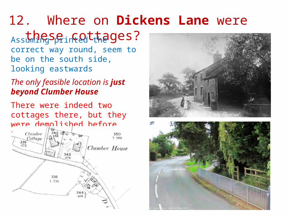
12. Where on Dickens Lane were these cottages?Assuming printed the correct way round, seem to be on the south side, looking eastwards
The only feasible location is just beyond Clumber House
There were indeed two cottages there, but they were demolished before 1906.....

13. What is the origin of the “Poynton Diamond” motif?
Many modern interpretations
But is the oldest surviving one that on “Oak Hurst”, London Road South, circa 1905? (photo right).....
Possibly from“Black Diamonds” = Coal?

14. What do the census property numbers mean?
In some of the censuses, many properties are numbered:e.g. Worth Clough Cottages (Petre Bank): 82-98 inclusive
Mount Vernon: 16-19 Ten Row: 124-133Long Row: 139-162 Newtown: 198-231
The highest number found was 298. The numbers are consistent over several censuses, but there are many gaps; perhaps only the ones which actually carried visible numbers were recorded?They all appear to be Vernon Estate tenanted properties.Up to around 195 the properties are numbered from east to west, indicating that the scheme was started in about 1870.After 196 the numbers are randomly scattered, indicating the order in which they were built or purchased after 1870?
Is this to do with rent collection? Any surviving records?

15. What was the building in the photo?London Road North, East side, between the Library Cottages and the coal yard (Woodside)
Perhaps the colliery mortuary?

16. Evidence for the 1790s gangroads
1789… Sir G. Warren has developed pits at the top of Poynton Park.....and carries coal from the pits to his public coal yard in Poynton village
1793 lease......together with the full and free use and enjoyment of the present Gangroad or Railed Road and all other roads now used and enjoyed in passing and repassing to and from aforesaid Mines.....
.....and to make a gangway or railed road from y aforesaid Coal Pits at Gees Farm in Poynton aforesaid to join into and communicate with y aforesaid coal pit road in Worth aforesaid.
1794......Nathaniel Wright, a lessee mentions Sir George Warren's Gangroad in a letter. In 1795 he mentions a "railway" that was intended to be used, a line that was "not Gees".
1796....in a lease to John Garman mention is made of the railway as it runs past Germans Pit to Barlow House Farm......any areas "as now are or hereafter may be damaged by the Gang Road“

Conjectural early gangroad routes?


A walk along the possible gangroads........
Top of the lake dam, from Vicarage Lane Turning onto South Park Drive
Looking up South Park Drive....... .....and as it was around 1900


Looking westwards back to Towers Rd Looking eastwards up to Prince Wood
By Horsepastures, looking east Ostler’s cottages at Horsepastures


And on the possible Gee’s tramroad route.....
View SE skirting German Pool Looking N from Prince Rd crossing
View N into Hawthorne Grove from Green La. Spur into Anson Pit area?

17. 1911 Census: Where were these properties?Do they still exist?
1. Cornwood2. Hollywood Lodge3. Oak Meadow = present Vicarage?
4. Pastures Clough5. Clemata Cottage

18. An appeal for old photographs!Higher Barn London Road NBarlow Fold – the garden frontCrescent Inn, London Road North Demolished c.1930
Eight Row, Chester Road (Ash Lodge there now) and
Poynton Place (or Church Row; now NatWest Bank) both these demolished circa 1900
Bower Stumps Farm, Chester Road Gone by 1906
The Old Police Station, London Rd N. To 1950s
Beechfield – Colliery Manager’s House, prior to 1946


Keith Jaggers
www.jaggers-heritage.com