potential environmental impacts from … environmental impacts from tapping electrical energies in...
TRANSCRIPT

POTENTIAL ENVIRONMENTAL IMPACTSPOTENTIAL ENVIRONMENTAL IMPACTSFROM TAPPING ELECTRICAL ENERGIESFROM TAPPING ELECTRICAL ENERGIESFROM TAPPING ELECTRICAL ENERGIESFROM TAPPING ELECTRICAL ENERGIES
IN THE STRAITS OF FLORIDAIN THE STRAITS OF FLORIDA
C.W. FinklC.W. Finkl††, R. , R. CharlierCharlier‡‡ & C. & C. MakowskiMakowski††† † Department of GeosciencesDepartment of Geosciences† † Department of GeosciencesDepartment of Geosciences
Florida Atlantic UniversityFlorida Atlantic UniversityBoca Raton, Boca Raton, Florida, USAFlorida, USA
‡‡ Free University of Brussels (VUB)Free University of Brussels (VUB)Brussels BelgiumBrussels BelgiumBrussels, BelgiumBrussels, Belgium
Renewable Ocean Energy, Palm Beach Gardens, Florida (2010)

PURPOSE AND GOALSPURPOSE AND GOALSU OS GO SU OS GO SShow relevance of ocean current Energy Production Units (EPU) along Show relevance of ocean current Energy Production Units (EPU) along the southeast Florida coastthe southeast Florida coastthe southeast Florida coastthe southeast Florida coast
Relate the configuration and environments of the continental shelf to Relate the configuration and environments of the continental shelf to cable laying scenarioscable laying scenarios
Introduce Introduce geomorphologicalgeomorphological maps of the shelf interpreted from maps of the shelf interpreted from LADS (Laser Airborne Depth Sounding) bathymetryLADS (Laser Airborne Depth Sounding) bathymetry
Indicate some potential environmental risks of transiting the Indicate some potential environmental risks of transiting the continental shelf with electrical transmission cablescontinental shelf with electrical transmission cables
Discuss possible solutions of potential risks to Discuss possible solutions of potential risks to Discuss possible solutions of potential risks to Discuss possible solutions of potential risks to coastal marine environments caused by coastal marine environments caused by connecting offshore connecting offshore EPUsEPUs with the electrical grid with the electrical grid gg ggonshoreonshore

OCEAN CURRENT GENERATED OCEAN CURRENT GENERATED ELECTRICITY: RISKS AND ELECTRICITY: RISKS AND
VULNERABILITIESVULNERABILITIESVULNERABILITIESVULNERABILITIESFailure of EPU (Energy Production Units)Failure of EPU (Energy Production Units)
Maintenance of Maintenance of EPUsEPUs ((e.ge.g. removing . removing biofoulingbiofouling films and films and encrusting organisms such as barnacles)encrusting organisms such as barnacles)
Hazards to submarines, migrating mammals and fishesHazards to submarines, migrating mammals and fishes
Hazards to surface shipping vessels during maintenanceHazards to surface shipping vessels during maintenancepp g gpp g g
Damage to sensitive coastal marine Damage to sensitive coastal marine i t d i i t ll tii t d i i t ll tienvironments during installationenvironments during installation

THE PROBLEM!THE PROBLEM!THE PROBLEM!THE PROBLEM!Getting electrical transmission cables ashore from Getting electrical transmission cables ashore from EPUsEPUs
Crossing sensitive environments on the continental shelfCrossing sensitive environments on the continental shelf
THE SOLUTION!THE SOLUTION!Learning how to avoid environmental Learning how to avoid environmental
THE SOLUTION!THE SOLUTION!Learning how to avoid environmental Learning how to avoid environmental
impacts impacts byby laying electrical laying electrical transmission lines ashore across transmission lines ashore across transmission lines ashore across transmission lines ashore across (over, under, through) coral reefs and (over, under, through) coral reefs and h d b tth d b tthard bottomshard bottoms

STUDY AREA STUDY AREA On Cusp ofOn Cusp of
NearcticNearctic and and NeotropicNeotropicT t i l T t i l E iE iTerrestrial Terrestrial EcoregionsEcoregions
Adjacent to areas defined in the WorldAdjacent to areas defined in the WorldDatabase Database on Protected Areason Protected AreasL.
Florida Keys National Marine Sanctuary &Florida Keys National Marine Sanctuary &associated aquatic associated aquatic preservespreserves
Aquatic Preserve of Biscayne BayAquatic Preserve of Biscayne BayParticularly Sensitive Sea Area (PSSA)Particularly Sensitive Sea Area (PSSA)
Everglades Big Cypress SwampEverglades Big Cypress Swamp
L.Okeechobee
EAA
Everglades, Big Cypress SwampEverglades, Big Cypress Swamp
Source:Source:Marine Environmental Protection Marine Environmental Protection
i ( ) f ii ( ) f i
Big CypressSwampGulf of
Committee (MEPC) of the International Committee (MEPC) of the International Maritime Organization (IMO)Maritime Organization (IMO)
Urban Sprawl Urban Sprawl –– Ocean to Everglades DikesOcean to Everglades Dikes
Mexico
FloridaBay
Urban Sprawl Urban Sprawl Ocean to Everglades DikesOcean to Everglades Dikes7 million people7 million people

SE FLORIDA URBAN CORRIDORSE FLORIDA URBAN CORRIDORAd Ad i t f i t f Adverse Adverse impacts from overimpacts from over--
populating sensitive populating sensitive environmentsenvironmentsVast Vast coastal wetland until post coastal wetland until post WW IIWW IIAtlantic Atlantic Coastal Ridge urbanized Coastal Ridge urbanized bybyAtlantic Atlantic Coastal Ridge urbanized Coastal Ridge urbanized byby
early early 1900s1900sEncroachment Encroachment of wetlands by midof wetlands by mid
1900s1900s5050% of Florida Everglades remains% of Florida Everglades remains
protectedprotectedTodayToday, 7 million people from Miami , 7 million people from Miami toto
Palm Palm BeachBeach!!
By 2020, population will be 10 million!By 2020, population will be 10 million!They will need electrical energy from They will need electrical energy from
clean (green) sourcesclean (green) sources
Is ocean power the answer?Is ocean power the answer?pp

COASTAL CITIES COASTAL CITIES –– MIAMIMIAMI, FLORIDA, FLORIDA
This is why we need additional clean (blue) ocean energy!This is why we need additional clean (blue) ocean energy!
Intense Inner City Intense Inner City DevelopmentDevelopmentIntense Inner City Intense Inner City DevelopmentDevelopmentNeeds Electricity to RunNeeds Electricity to Run

EXAMPLES OF OCEAN CURRENT EXAMPLES OF OCEAN CURRENT GENERATED ELECTRICITY GENERATED ELECTRICITY EPUsEPUs

Marine Current Turbines Ltd.Marine Current Turbines Ltd.
20022002--2006 Installation and testing of the first commercial2006 Installation and testing of the first commercial--scalescalemonopilemonopile--mounted experimental 300kW single 11m diametermounted experimental 300kW single 11m diameterrotor system off rotor system off LynmouthLynmouth, Devon, UK. , Devon, UK.

The Dream Florida HydroEnergy Farm
Popular MechanicsPopular Mechanics

Early in 2001 marine experts of United Nations organizations listed issues of global concern regarding deterioration of the marine environment:
Eutrophication and anoxiaHarmful algal blooms (HABS)Classical contaminants (e.g. sewage, metals, petroleum hydrocarbons)DeforestationDeforestationIncreased or decreased mobilization of sedimentsDemise of coral reefsLoss of wetlandsHabitat destructionHabitat destructionClimate change and sea-level riseInundation as a consequence of physical alterationIncreased risks to human healthReduced biodiversity educed b od e s tyOverfishingExploitation of coastal mineral resources, particularly sand and gravelLitter
-- GESAMP71:09
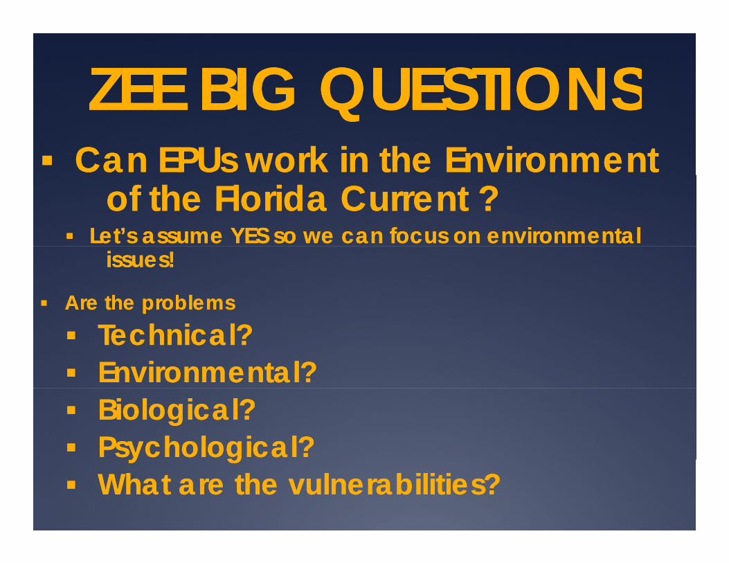
ZEE BIG QUESTIONSZEE BIG QUESTIONSZEE BIG QUESTIONSZEE BIG QUESTIONSCan Can EPUsEPUs work in the Environment work in the Environment
of the Florida Current ?of the Florida Current ?Let’s assume YES so we can focus on environmentalLet’s assume YES so we can focus on environmental
issuesissues!!
Are the problems Are the problems TechnicalTechnical??EnvironmentalEnvironmental??BiologicalBiological??PsychologicalPsychological??y gy gWhat What are the vulnerabilities?are the vulnerabilities?
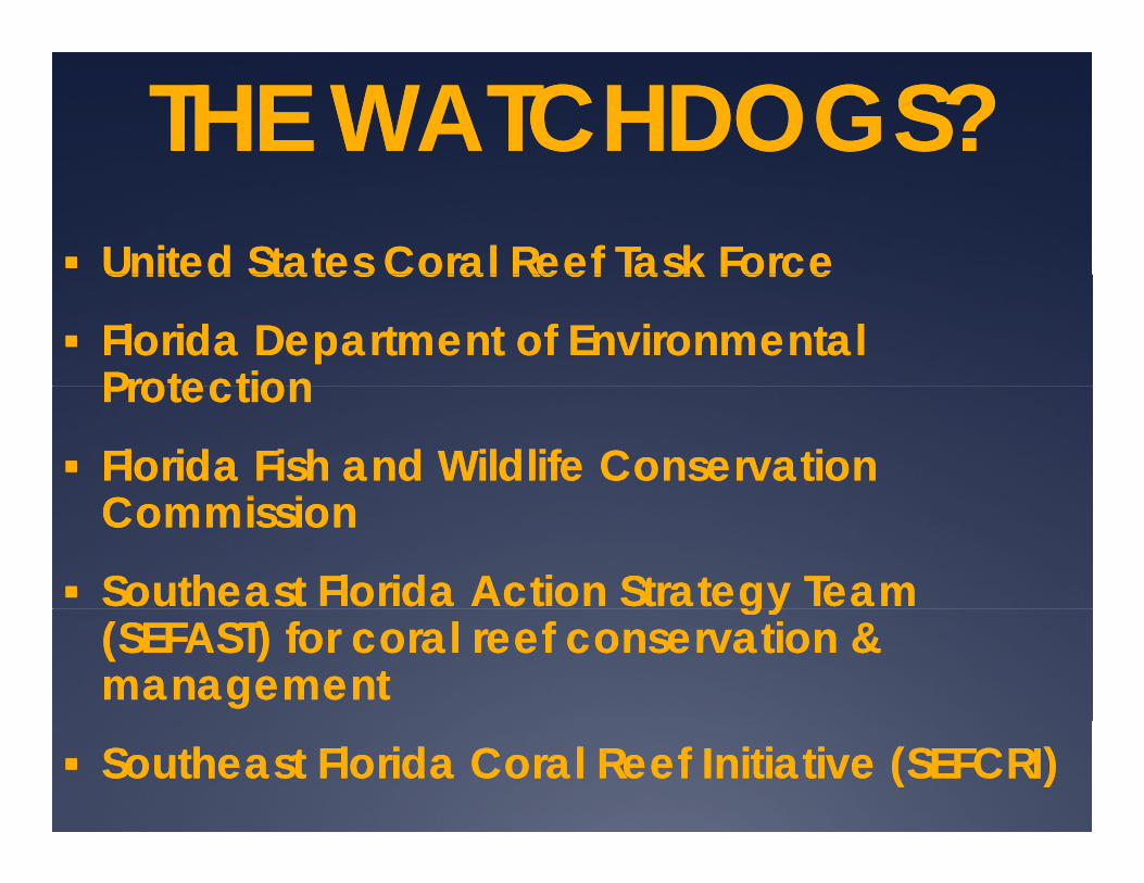
THE WATCHDOGS?THE WATCHDOGS?United States Coral Reef Task ForceUnited States Coral Reef Task ForceUnited States Coral Reef Task ForceUnited States Coral Reef Task Force
Florida Department of Environmental Florida Department of Environmental ProtectionProtectionProtectionProtection
Florida Fish and Wildlife Conservation Florida Fish and Wildlife Conservation C i iC i iCommissionCommission
Southeast Florida Action Strategy Team Southeast Florida Action Strategy Team gygy(SEFAST) for coral reef conservation & (SEFAST) for coral reef conservation & managementmanagement
Southeast Florida Coral Reef Initiative (SEFCRI)Southeast Florida Coral Reef Initiative (SEFCRI)

IMPACTS TO PELAGIC &IMPACTS TO PELAGIC &BENTHIC HABITATS?BENTHIC HABITATS?BENTHIC HABITATS?BENTHIC HABITATS?
Trawling for shrimpTrawling for shrimpPot fisheries for Pot fisheries for crabscrabsMigratory routes for large mammals Migratory routes for large mammals ((e.g. e.g.
))whaleswhales, turtles), turtles)Schooling fish, sport fisheriesSchooling fish, sport fisheries
Florida Reef TractFlorida Reef TractInner continental shelfInner continental shelf

REGIONAL REGIONAL SETTINGSETTING
SE Florida AtlanticSE Florida AtlanticContinental shelfContinental shelf is aboutis about2 km wide at2 km wide at its narrowest its narrowest point off point off Port EvergladesPort Evergladespoint off point off Port EvergladesPort Everglades(red arrow) in Port Ever(red arrow) in Port Ever--glades. Shelf drops off to glades. Shelf drops off to 800 m depth after 800 m depth after shelf shelf break break atat 3030--40 40 m water m water depth.depth.
Narrowest part of the Narrowest part of the shelfshelfNarrowest part of the Narrowest part of the shelfshelflies lies betweenbetween the two the two red red bars marking northern and bars marking northern and southern boundaries.southern boundaries.
85 km85 km
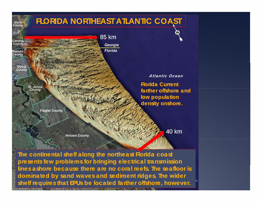
FLORIDA NORTHEAST ATLANTIC COASTFLORIDA NORTHEAST ATLANTIC COAST
85 km85 km
Florida Current Florida Current farther offshore and farther offshore and low population low population density onshore.density onshore.
40 km40 km
The continental shelf along the northeast Florida coast The continental shelf along the northeast Florida coast presents few problems for bringing electrical transmission presents few problems for bringing electrical transmission lines ashore because there are no coral reefs. The seafloor is lines ashore because there are no coral reefs. The seafloor is dominated by sand waves and sediment ridges. The wider dominated by sand waves and sediment ridges. The wider shelf requires that shelf requires that EPUsEPUs be located farther offshore, however.be located farther offshore, however.
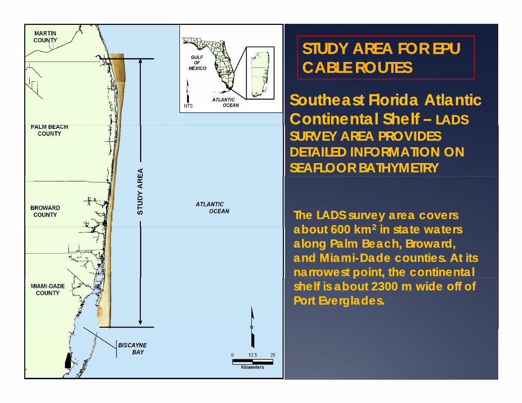
STUDY STUDY AREAAREA FOR EPU FOR EPU CABLE ROUTESCABLE ROUTES
Southeast Southeast Florida Atlantic Florida Atlantic Continental Continental Shelf Shelf –– LADS LADS SURVEY AREA PROVIDES SURVEY AREA PROVIDES DETAILED INFORMATION ON DETAILED INFORMATION ON SEAFLOOR BATHYMETRYSEAFLOOR BATHYMETRY
The LADS survey area covers The LADS survey area covers about 600 about 600 kmkm22 in in state waters state waters about 600 about 600 kmkm22 in in state waters state waters along Palm Beach, Broward, along Palm Beach, Broward, and Miamiand Miami--Dade countiesDade counties. At its . At its narrowest point, the continental narrowest point, the continental ppshelf is about 2300 shelf is about 2300 mm wide off of wide off of Port Everglades.Port Everglades.

GrandGrandBahamaBahama
Southeast FloridaSoutheast FloridaAtlantic ShelfAtlantic Shelf
UpperUpperSlopeSlope
BiscayneBiscayneBayBayBayBay
ShelfShelfBreakBreak

LEGEND FOR SE LEGEND FOR SE FLORIDA ATLANTIC FLORIDA ATLANTIC
CONTINENTAL SHELFCONTINENTAL SHELFAbout 42 geomorphological About 42 geomorphological mapping units grouped bymapping units grouped bymapping units grouped bymapping units grouped by
Continental SlopeContinental SlopeCoral Reef (Florida Reef Tract)Coral Reef (Florida Reef Tract)HardbottomHardbottom (Bedrock exposure)(Bedrock exposure)Sand Bottom FormsSand Bottom FormsTidal FeaturesTidal FeaturesTidal FeaturesTidal Features
Applied to LADS imageryApplied to LADS imagery
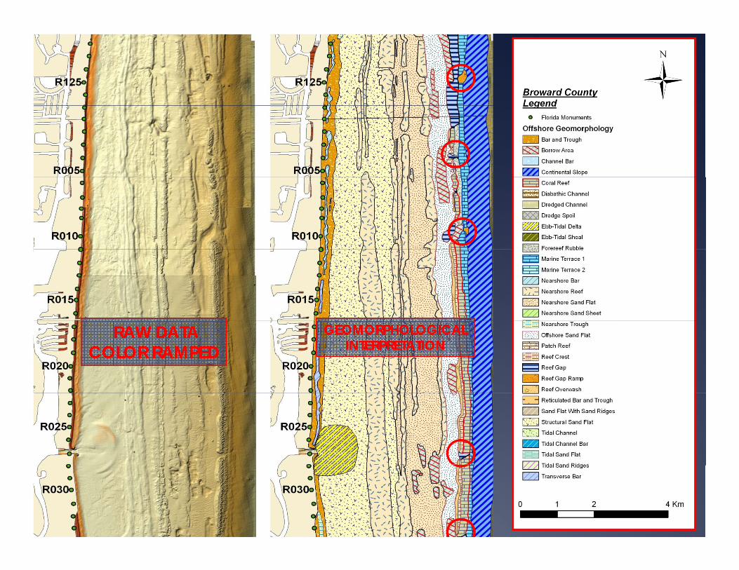
RAW DATARAW DATACOLOR RAMPEDCOLOR RAMPED
GEOMORPHOLOGICALGEOMORPHOLOGICALINTERPRETATIONINTERPRETATION

LADS MAPPING PROCEDURELADS MAPPING PROCEDUREWindow showing Window showing correspondence of correspondence of mapping units with mapping units with LADS imagery LADS imagery (bathymetry).(bathymetry).
Beach RidgesBeach RidgesSand FlatSand FlatDiabathic ChannelsDiabathic Channels
Dredge SpoilDredge Spoil
Sand SandEnd of End of Drowned Drowned Beach Ridge Beach Ridge
SandFlat
SandFlat
ggPlainPlain
B i i fB i i f
Bahamas FractureBahamas FractureZoneZone
Beginning of Beginning of Florida Reef Florida Reef TractTract

HOW DO WE BRING AN ELECTRICAL HOW DO WE BRING AN ELECTRICAL TRANSMISSION LINE ASHORE?TRANSMISSION LINE ASHORE?
Example of how a Example of how a surface cable might be surface cable might be laid across the shelf from laid across the shelf from an EPU farm in the an EPU farm in the Straits of Florida.Straits of Florida.
Note that the cable Note that the cable enters the shelf through enters the shelf through a reef gap and then a reef gap and then follows an interfollows an inter reefalreefalfollows an interfollows an inter--reefalreefalsand flat, goes through sand flat, goes through another reef gap, then another reef gap, then goes to Port Everglades goes to Port Everglades via the navigation via the navigation channel, and then to channel, and then to ,,land.land.
This example poses the This example poses the fewest environmental fewest environmental hazards but creates hazards but creates other problems.other problems.
Finkl, C.W., 2004. Leaky valves in littoral Finkl, C.W., 2004. Leaky valves in littoral sediment budgets: Loss of sediment budgets: Loss of nearshorenearshoreggsand to deep offshore zones via chutes sand to deep offshore zones via chutes in barrier reef systems, southeast coast in barrier reef systems, southeast coast of Florida, USA. of Florida, USA. Journal of Coastal Journal of Coastal ResearchResearch, 20(2), 605, 20(2), 605--611.611.


THE PROBLEM WITH SURFACE ROUTES THE PROBLEM WITH SURFACE ROUTES ON TOP OF THE SEAFLOORON TOP OF THE SEAFLOORON TOP OF THE SEAFLOORON TOP OF THE SEAFLOOR
There is no direct route from the EPU farm to the shoreThere is no direct route from the EPU farm to the shoreThere is no direct route from the EPU farm to the shoreThere is no direct route from the EPU farm to the shore
The cable route must pass through a reef gapThe cable route must pass through a reef gap
Reef gaps do not line up between reef tractsReef gaps do not line up between reef tracts
Reef gaps do not line up with with breaks in hard groundsReef gaps do not line up with with breaks in hard groundsReef gaps do not line up with with breaks in hard groundsReef gaps do not line up with with breaks in hard grounds
Cables laid on sand flats compromise future other uses of Cables laid on sand flats compromise future other uses of the sand resource for beach renourishment for examplethe sand resource for beach renourishment for examplethe sand resource, for beach renourishment for examplethe sand resource, for beach renourishment for example
The solution? Go underground with directional drilling The solution? Go underground with directional drilling UNDER the coral reefs and hard groundsUNDER the coral reefs and hard groundsUNDER the coral reefs and hard groundsUNDER the coral reefs and hard grounds

DIRECTIONAL DRILLING UNDER FLORIDA REEF TRACTDIRECTIONAL DRILLING UNDER FLORIDA REEF TRACT
From land under the continentalFrom land under the continentalshelf and out to sea on the slopeshelf and out to sea on the slope
From sea under the continentalFrom sea under the continentalshelf and onto the landshelf and onto the land
C ti l iC ti l i li th d d ti l li th d d ti l Conventional wireConventional wire--line method and conventional line method and conventional equipment are used without modification.equipment are used without modification.Fixing the direction of drilling can be done easily Fixing the direction of drilling can be done easily by electronic by electronic multishotmultishot survey devices.survey devices.by e ec o c by e ec o c u s ou s o su ey de ces.su ey de ces.

GrandGrandBahamaBahama
Southeast FloridaAtlantic Shelf
UpperSlope
Transmission Line
BiscayneBiscayneBayBay Example of a transmission routeExample of a transmission routeBayBay
ShelfShelfBreakBreak
Example of a transmission routeExample of a transmission routefrom the Straits of Florida to landfrom the Straits of Florida to land

DRILLING THROUGH LIMESTONEDRILLING THROUGH LIMESTONEPOSES POTENTIAL PROBLEMSPOSES POTENTIAL PROBLEMS
Limestones are typically vuggyHoles and cavities in limestones may reach the surface of the coral reefLeakage of drilling fluids (lubricants and additives), muds (e.g. bentonite
l ) di t ti th l f f th i fclay) can cause sedimentation on the coral reef surface smothering reefcommunities
Cavity connection with surfaceCavity connection with surface
Solution holes
Cavities

IMPACTS OF DRILLING FLUIDSIMPACTS OF DRILLING FLUIDSON CORAL REEFSON CORAL REEFS
The skeletal extension and corallite shape of i di id l f th C ibb d tl ti f
ON CORAL REEFSON CORAL REEFS
individuals of the Caribbean and Atlantic reef-building coral Montastrea annularis (Ellis and Solander) were measured after more than six weeks' continuous flow-through exposure in l b t i t t t t f 0 1 10 d laboratory aquaria to treatments of 0, 1, 10 and 100-ppm (l 1-1) drilling mud. Linear increase of the skeleton (extension rate) and fossa length were significantly depressed in the 100-ppm t t t Ch i t 100 d illi treatment. Chronic exposure to 100-ppm drilling mud impairs coral skeletal growth rate and possibly interferes with sediment rejection capability by lowering calical relief.
Dodge, R.E., 1992. Marine Biology, 71(2), 141-147.

EPA reports potential EPA reports potential adverse impacts of drilling adverse impacts of drilling adverse impacts of drilling adverse impacts of drilling fluids and fluids and mudsmuds on coral on coral reefs. But, presence of reefs. But, presence of drilling drilling mudsmuds must be must be
t i t ti t i t ti present in concentrations present in concentrations greater than 100 greater than 100 ppmppm for for four weeks or longer to four weeks or longer to damage coral reefs.damage coral reefs.gg
There is potential for There is potential for environmental damage to environmental damage to coral reefs from leakage of coral reefs from leakage of coral reefs from leakage of coral reefs from leakage of drilling fluids and drilling fluids and mudsmuds, but , but waves and currents would waves and currents would tend to diminish possible tend to diminish possible impacts along the FRT.impacts along the FRT.

CONCLUSIONSCONCLUSIONSThe future presence of The future presence of EPUsEPUs in the Straits of Florida is a possibilityin the Straits of Florida is a possibility
Th th SE Fl id b ti d ‘Bl E ’ (O PTh th SE Fl id b ti d ‘Bl E ’ (O PThe the SE Florida conurbation needs ‘Blue Energy’ (Ocean PowerThe the SE Florida conurbation needs ‘Blue Energy’ (Ocean Power
Getting electrical transmission lines ashore poses environmental Getting electrical transmission lines ashore poses environmental problemsproblemsproblemsproblems
GeomorphologicalGeomorphological maps of the seafloor on the continental shelf will maps of the seafloor on the continental shelf will help determine the least damaging cable routeshelp determine the least damaging cable routeshelp determine the least damaging cable routeshelp determine the least damaging cable routes
Cable approach routes will have to come ashore:Cable approach routes will have to come ashore:(1)(1) On the surface of the seafloor through Reef Gaps or Reef Gap RampsOn the surface of the seafloor through Reef Gaps or Reef Gap Ramps( )( ) g p p pg p p p(2)(2) In InterIn Inter--reefalreefal sand flats and thence through sand flats and thence through hardgroundshardgrounds(3)(3) Underneath the FRT via directional drilling from land to the continental Underneath the FRT via directional drilling from land to the continental
slope below the Shelf Break where shelfslope below the Shelf Break where shelf--edge coral reefs occur oredge coral reefs occur or(4)(4) From directional drilling offshore through the face of the upper From directional drilling offshore through the face of the upper
continental slope going under the FRT and outcropping on landcontinental slope going under the FRT and outcropping on land

THANK YOU THANK YOU FOR YOUR FOR YOUR ATTENTIONATTENTIONATTENTIONATTENTION