postglacial volcanism in icelandraman/papers2/thordarson and...eruptions, including the three...
TRANSCRIPT
Reviewed research article
Postglacial volcanism in Iceland
Thorvaldur Thordarson1 and Ármann Höskuldsson2
1School of GeoSciences, University of Edinburgh, Grant Institute, King’s Buildings, West Mains Rd., Edinburgh EH93JW, UK2Institute of Earth Sciences, University of Iceland, Sturlugata 7, 101 Reykjavík, Iceland
[email protected], [email protected]
Abstract – Iceland is one of the most active and productive terrestrialvolcanic regions, with eruption frequencyof ≥20 events per century and magma output rates of≥5 km3 per century. Although Iceland is dominated bymafic magmatism and volcanism, as is evident from 91:6:3 distribution of mafic, intermediate and silicic erup-tions, its record also features most common terrestrial magma types and eruption styles. Postglacial volcanismis confined to the neovolcanic zones where 30 active volcanicsystems are responsible for most of the Holoceneactivity. On the basis of our current post-glacial eruptiondata set we estimate that Icelandic volcanism hasproduced around 2400 eruptions and about 566±100 km3 of erupted magma in the last 11 ka. Effusive activ-ity accounts for∼500 eruptions; the remainder is explosive and dictated by subglacial mafic events (∼77%),demonstrating strong environmental influence on eruption styles in Iceland. In terms of magma output therecord is dominated by large volume (>1 km3) effusive mafic eruptions. About 50 such eruptions have occurredthroughout postglacial time or∼2% of the total number of eruptions. However, collectively these events pro-duced about 55% of the postglacial magma volume. The EasternVolcanic Zone is responsible for >80% ofthe eruptions and∼60% of the erupted magma volume and has been by far the most prolific producer amongthe neovolcanic zones. Furthermore, the volume of mafic effusive eruptions is not evenly distributed throughpost-glacial time, because only 30% (∼111 km3) of the total volume was produced in the last 5 ka and the re-maining 70% ( 258 km3) between 5–11 ka. However, the production rate per millennia within these two periodsappears to be fairly even, ranging from 20–30 km3 in <5 ka period and 35-40 km3 in the 5–10 ka interval. Theexception is the 10–11 ka interval, when∼70 km3 of mafic lava was formed by the effusive activity or close todouble the volume produced per millennia in the period that followed.
INTRODUCTION
Volcanism in Iceland is diverse, spanning almostthe range of common terrestrial magma types anderuption styles (e.g. Thordarson and Larsen, 2007).Nonetheless, it is dominated by mafic magmatismand volcanism, representing∼91% of the total post-glacial magma output and number of eruptions. Ice-land is also one of the most active and productivesubaerial volcanic region on Earth, with eruption fre-quency of≥20 events per century and magma out-
put rates of∼8 km3 per century in historic time (i.e.over the last 1100 years). Furthermore, the volcanismis symbolized by mafic effusive eruptions, althoughmixed (i.e. tephra- and lava-producing) and explosivemafic eruptions are more common in Iceland thanin other compatible volcanic regions. The relativelyhigh frequency of mixed eruptions is primarily dueto prolific activity at the Hekla volcano during theHolocene, whereas the mafic explosive events resultsfrom the country’s geography, which promotes fre-
JÖKULL No. 58, 2008 197
Th. Thordarson and Á. Höskuldsson
quent subglacial and submarine (i.e. hydromagmatic)eruptions, including the three largest terrestrial ex-plosive basalt eruptions in the last 10 ka (Larsen,1984, 2005; Jóhannsdóttiret al., 2006). Silicic vol-canism does feature strongly in Iceland and some ofthe largest explosive eruptions in Europe originatedat Icelandic volcanoes and produced tephra layersthat now serve as time markers in Holocene sedimentsequences on both sides of the North Atlantic (e.g.Hafliðasonet al., 2000). Consequently, Iceland is of-ten identified as an ideal ’natural’ laboratory for vol-canological research and as such has attracted manyresearchers for more than a Century.
The task we were asked to undertake is to producean overview of post-glacial volcanism in Iceland (i.e.over the last 11ka). Although this task may appearstraightforward, the perception of the volcanism ismanifold and the topic can be approached from num-ber of perspectives. To keep the scope of the study atmanageable length we limit our treatment to the sub-aerial part of the volcanism and focus our efforts onvolcanic eruptions and their surface products. Conse-quently, no attempt is made here to evaluate subsur-face volcanic processes despite their significance, es-pecially in regard to volcano monitoring. Also, noteall ages are given as calendar years.
In order to produce an up to date overview of thepostglacial volcanic activity, we have compiled all ofthe eruption data available in published papers andrecords. Here we evaluate the results provided by thisdata set in terms of number of postglacial eruptionsand their magma outputs. We also use this dataset toproduce an overview of the eruption styles that typ-ify Icelandic volcanism and provide some assessmentof its authenticity. One aspect of the volcanic activ-ity that is not included because of space limitationsis outgassing of magmatic volatiles during eruptionas well as their potential environmental and climaticeffects. Studies of Icelandic eruptions and their prod-ucts have contributed significantly to this branch ofvolcanology and appropriate bibliography to studieson this topic can be obtained from Thordarsonet al.(1996, 2001), Nicholset al. (2002), Thordarson andSelf (2003), Höskuldssonet al. (2006), Mouneet al.(2006) and Omanet al. (2006); Óladóttiret al., 2007.
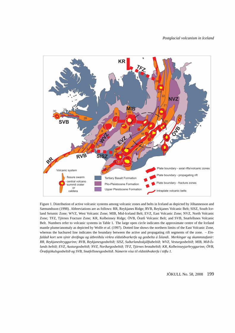
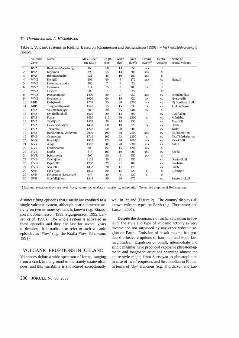
VOLCANISM IN ICELANDThe Iceland Basalt Plateau rises more than 3000 mabove the surrounding sea floor, has crustal thicknessof 10–40 km and covers about 350,000 km2. It isthe only currently active part of the∼2000 km-longNorth Atlantic Igneous Province (e.g. Gudmundsson,2000; Saunderset al., 1997). The neovolcanic zonesin Iceland, which collectively cover∼30,000 km3, de-lineate discrete 15–50 km-wide belts of active fault-ing and volcanism. The nomenclature used here forindividual zones is shown on Figure 1. The neo-volcanic zones are further divided into volcanic sys-tems, which can be viewed as the principal geologicalstructure in Iceland. It is characterised by conspicu-ous volcano-tectonic architecture that features a fis-sure (dyke) swarm or a central volcano or both andhas a typical lifetime of 0.5–1.5 million years (e.g.Jakobssonet al., 1978; Jakobsson, 1979; Sæmunds-son, 1978, 1979; Guðmundsson, 1995b, 2000). Thefissure swarms are elongate structures (5 to 20 km-wide and 50 to 200 km-long) that normally are alignedsub-parallel to the axis of the hosting volcanic zone.The central volcano, when present, is the focal pointof eruptive activity and normally the largest edificewithin each system (Figure 1). A total of thirty ac-tive volcanic systems are identified; 3 within the RVZ,6 in the WVZ, 2 in MIB, 5 in the NVZ, 8 in theEVZ and 3 in each of the intraplate volcanic belts(Table 1). The size of individual systems ranges from∼25 to 2500 km2 and their length from 7 to 200 km.The largest system is the Bárdarbunga-Veidivötn vol-canic system and the smallest the Hrómundartindursystem. Twenty systems feature a fissure swarm and12 have well-developed and mature swarms, 5 areof moderate maturity and 4 are embryonic (Thord-arson and Larsen, 2007). In total, 23 central volca-noes are known from 19 volcanic systems and 4 sys-tems - Hofsjökull, Tungnafellsjökull, Bárdarbunga-Veidivötn and Grímsvötn - contain two central vol-canoes (Figure 1; Table 1).
Spreading and rifting is not a continuous processand events on the volcanic systems are closely linkedto plate movements (e.g. Sigurdsson and Sparks,1978; Björnssonet al., 1979; Brandsdóttir and Einars-son, 1979; Björnsson, 1985). Spreading takes place in
198 JÖKULL No. 58, 2008
Postglacial volcanism in Iceland
Tertiary Basalt Formation
Volcanic system
fissure swarm
central volcanosummit crater
orcaldera
Plio-Pleistocene Formation
Upper Pleistocene Formation
12 3
4 56
7
8
910
11
12
13
1415
16 17
1819
20
21
22
23
24
25
26
2728
2930
NVZ
EVZ
T ZF
SVB
ÖVB
RR
KR
SISZRVB
WVZ
MIB
Plate boundary - axial rifts/volcanic zones
Plate boundary - fracture zones
Intraplate volcanic belts
Plate boundary - propagating rift
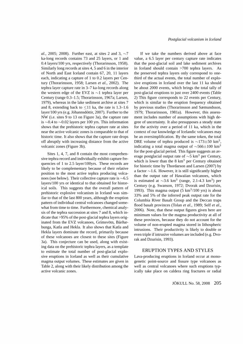
Figure 1. Distribution of active volcanic systems among volcanic zones and belts in Iceland as depicted by Jóhannesson andSæmundsson (1998). Abbreviations are as follows: RR, Reykjanes Ridge; RVB, Reykjanes Volcanic Belt; SISZ, South Ice-land Seismic Zone; WVZ, West Volcanic Zone; MIB, Mid-Iceland Belt; EVZ, East Volcanic Zone; NVZ, North VolcanicZone; TFZ, Tjörnes Fracture Zone; KR, Kolbeinsey Ridge; ÖVB, ÖræfiVolcanic Belt; and SVB, Snæfellsnes VolcanicBelt. Numbers refer to volcanic systems in Table 1. The large open circle indicates the approximate centre of the Icelandmantle plume/anomaly as depicted by Wolfeet al. (1997). Dotted line shows the northern limits of the East Volcanic Zone,whereas the hachured line indicates the boundary between the active andpropagating rift segments of the zone. –Ein-faldað kort sem sýnir dreifingu og útbreiðslu virkra eldstöðvarkerfa og gosbelta á Íslandi. Merkingar og skammstafanir:RR, Reykjaneshryggurinn; RVB, Reykjanesgosbeltið; SISZ, Suðurlandsskjálftabeltið; WVZ, Vesturgosbeltið; MIB, Mið-Ís-lands beltið; EVZ, Austurgosbeltið; NVZ, Norðurgosbeltið; TFZ, Tjörnesbrotabeltið; KR, Kolbeinseyjarhryggurinn; ÖVB,Öræfajökulsgosbeltið og SVB, Snæfellsnesgosbeltið. Númerin vísa til eldstöðvakerfa í töflu 1.
JÖKULL No. 58, 2008 199
Th. Thordarson and Á. Höskuldsson
Table 1. Volcanic systems in Iceland. Based on Jóhannesson and Sæmundsson (1998). –Virk eldstöðvarkerfi áÍslandi.
Volcanic Name Max. Elev.1 Length Width Area Fissure Central Name ofZone (m a.s.l.) (km) (km) (km2) swarm2 volcano central volcano
1 RVZ Reykjanes/Svartsengi 163 58 13 350 xxx d2 RVZ Krýsuvík 393 55 13 300 xxx d3 RVZ Brennisteinsfjöll 621 45 10 280 xxx d4 WVZ Hengill 803 60 9 370 xxx cv Hengill5 WVZ Hrómundartindur 283 7 8 25 d6 WVZ Grímsnes 214 15 8 100 xx d7 WVZ Geysir◦ 600 7 7 25 d8 WVZ Prestahnjúkur 1400 80 27 950 xxx cv Prestahnjúkur9 WVZ Hveravellir 1000 60 18 720 xx cv Hveravellir10 MIB Hofsjökull 1763 95 38 2200 xxx cv Hj./Kerlingarfjöll11 MIB Tungnafellsjökull 1520 55 15 530 xx cv Tj./Hágöngur12 EVZ Vestmannaeyjar 283 28 25 <480 xx d13 EVZ Eyjafjallajökull 1666 30 14 300 cv Eyjafjallaj.14 EVZ Katla 1450 110 30 1300 x cv Mýrdalsj.15 EVZ Tindfjöll◦ 1462 20 14 230 cv Tindfjöll16 EVZ Hekla/Vatnafjöll 1491 60 19 720 xx cv Hekla17 EVZ Torfajökull 1278 50 20 900 cv Torfaj.18 EVZ Bárdarbunga/Veiðivötn 2009 190 28 2500 xxx cv Bb./Hamarinn19 EVZ Grímsvötn 1719 100 23 1350 x cv Gv./Thórdarhyrna20 NVZ Kverkfjöll 1929 120 20 1600 xxx cv Kverkfjöll21 NVZ Askja 1510 200 20 2300 xxx cv Askja22 NVZ Fremrinámur 800 150 15 1200 xxx d23 NVZ Krafla 818 100 19 900 xxx cv Krafla24 NVZ Þeistareykir 600 90 9 650 xxx d25 ÖVB Öræfajökull 2119 20 21 250 cv Öræfajökull26 ÖVB Esjufjöll◦ 1700 25 21 400 cv Snæhetta27 ÖVB Snæfell◦ 1833 20 11 170 cv Snæfell28 SVB Ljósufjöll 1063 80 15 720 x d Ljósufjöll29 SVB Helgrindur (Lýsuskarð) 647 30 8 220 x d30 SVB Snæfellsjökull 1446 30 20 470 cv Snæfellsjökull
1Maximum elevation above sea level.2xxx, mature; xx, moderate maturity; x, embryonic.◦No verified eruption of Holocene age.
distinct rifting episodes that usually are confined to asingle volcanic system, although near-concurrent ac-tivity on two or more systems is known (e.g. Einars-son and Jóhannesson, 1989; Sigurgeirsson, 1995; Lar-senet al. 1998). The whole system is activated inthese episodes and they can last for several yearsto decades. It is tradition to refer to such volcanicepisodes as ’Fires’ (e.g. the Krafla Fires; Einarsson,1991).
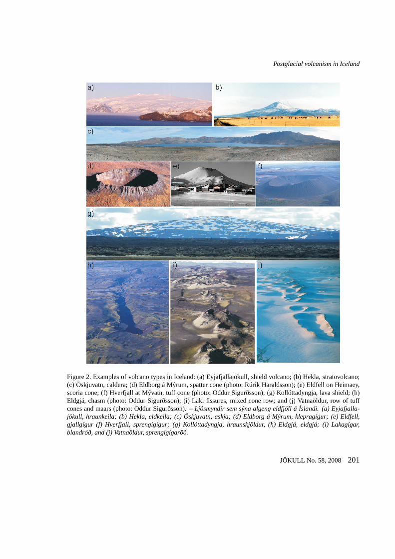
VOLCANIC ERUPTIONS IN ICELANDVolcanoes define a wide spectrum of forms, rangingfrom a crack in the ground to the stately stratovolca-noes, and this variability is showcased exceptionally
well in Iceland (Figure 2). The country displays allknown volcano types on Earth (e.g. Thordarson andLarsen, 2007).
Despite the dominance of mafic volcanism in Ice-land, the style and type of volcanic activity is verydiverse and not surpassed by any other volcanic re-gion on Earth. Emission of basalt magma has pro-duced effusive eruptions of hawaiian and flood lavamagnitudes. Expulsion of basalt, intermediate andsilicic magmas have produced explosive phreatomag-matic and magmatic eruptions spanning almost theentire style range; from Surtseyan to phreatoplinianin case of ’wet’ eruptions and Strombolian to Plinianin terms of ’dry’ eruptions (e.g. Thordarson and Lar-
200 JÖKULL No. 58, 2008
Postglacial volcanism in Iceland
Figure 2. Examples of volcano types in Iceland: (a) Eyjafjallajökull, shield volcano; (b) Hekla, stratovolcano;(c) Öskjuvatn, caldera; (d) Eldborg á Mýrum, spatter cone (photo: Rúrik Haraldsson); (e) Eldfell on Heimaey,scoria cone; (f) Hverfjall at Mývatn, tuff cone (photo: Oddur Sigurðsson); (g) Kollóttadyngja, lava shield; (h)Eldgjá, chasm (photo: Oddur Sigurðsson); (i) Laki fissures,mixed cone row; and (j) Vatnaöldur, row of tuffcones and maars (photo: Oddur Sigurðsson). –Ljósmyndir sem sýna algeng eldfjöll á Íslandi. (a) Eyjafjalla-jökull, hraunkeila; (b) Hekla, eldkeila; (c) Öskjuvatn, askja; (d) Eldborg á Mýrum, klepragígur; (e) Eldfell,gjallgígur (f) Hverfjall, sprengigígur; (g) Kollóttadyngja, hraunskjöldur, (h) Eldgjá, eldgjá; (i) Lakagígar,blandröð, and (j) Vatnaöldur, sprengigígaröð.
JÖKULL No. 58, 2008 201
Th. Thordarson and Á. Höskuldsson
sen, 2007). Consequently, the eruptions in Iceland, re-gardless of their environmental setting, can be purelyexplosive or effusive or a mixture of both. Accordingto the classification scheme of Thorarinsson (1981a),an eruption is effusive if lava comprises≥95% of thevolume of erupted products and explosive if the DRE-volume (Dense Rock Equivalent volume) of the tephrais ≥95% of the total volume produced. Anything in-between is considered as a mixed eruption. However,it is difficult to apply this classification scheme toHolocene eruptions because the relative proportion oftephra to lava is not known for majority of the events.Therefore, we have elected to let all identified lavasrepresent an effusive eruption and by the same to-ken tephra layers mark an explosive event. However,when the same eruption is known to have producedtephra and lava, it is counted as explosive if the vol-ume of tephra is >50% of the total DRE product vol-ume and effusive when the corresponding value forthe lava is≥50%.
NUMBER OF ERUPTIONS ANDMAGMA VOLUMES
Over the last 40 years or so a number of researchershave made an ample effort in documenting Holoceneeruptive events, mapping distribution of Holocenelava and recording the tephra stratigraphy (e.g. Jóns-son, 1978a, 1978b, 1983; Jakobsson, 1968, 1979;Jóhannesson, 1982, 1983; Jóhannsdóttir, 2007; Lar-sen, 1979, 1982, 1984, 2000; Larsen and Thor-arinsson, 1977; Larsenet al., 1998; 1999, 2001,2002; Höskuldsson and Imsland, 1998; Mattson andHoskuldsson, 2003; Óladóttiret al., 2005, 2008;Steinthorsson, 1978; Sigbjarnarson, 1988, 1996; Sig-valdasonet al., 1992; Sigurgeirsson, 1992, 1995; Sin-ton et al., 2005; Sæmundsson, 1991, 1992, 1995;Sæmundsson and Friðleifsson, 2001; Torfasonet al.,1993; Thorarinsson, 1951, 1958, 1965, 1967a, 1970,1974, 1975; Vilmundardóttir, 1977; Vilmundardóttiret al., 1983, 1988, 1990, 1999a, 1999b). Despitethis effort, the record of Holocene eruptions in Ice-land is not complete, which exerts some limitationon assessments of postglacial volcanism in Icelandand the overview presented here, therefore, only gives
ball-park figures for the essential eruption variables.Magma volume figures are given here as DRE vol-umes, unless stated otherwise.
LAVA-PRODUCING ERUPTIONSThe record on number and volume of lava-producingeruptions is reasonably complete and indicates thatthe number of postglacial effusive eruptions is 501,thereof 56 since settlement (i.e. last 1140 yrs). How-ever, although the ’Fires’ of historic time are countedas one event, that is not the case for the prehis-toric events. Individual ’Fires’ in historic time typ-ically feature several eruptions (i.e. 2–9 events) andthus it is likely that we overestimate the actual num-ber of effusive eruptions in prehistoric time by 10–15%. Notwithstanding, these eruptions produced∼390±50 km3 of lava (Table 2). About 90% ofthe events are mafic and collectively account for∼370 km3 (94%) of the post-glacial lava volume.Currently, there are 29 intermediate and 15 silicicevents on record, which produced∼23 km3 (5.3%)and∼1.2 km3 (0.3%) of lava, respectively. Althoughsignificant uncertainties remain regarding number andvolume of events in the post-glacial lava successions,the record for individual volcanic zones is reasonablycoherent and is summarized in Table 2. The compi-lation indicates that the volcanic zones of the axialrift (i.e. RVB, WVZ, MIB, and NVZ) have featured288 effusive eruptions in post-glacial time, including29 historic events, and produced∼121±20 km3 ofmagma. All except two of the events in our recordsare mafic (>99%). However, the most prolific pro-ducer of the volcanic zones is the EVZ with∼163events and lava volume of∼174±10 km3 (Table 2).EVZ is also the site for 27 out of 29 (93%) interme-diate events and 12 out of 15 (80%) of effusive siliciceruptions. Additional 52 effusive eruptions are knownfrom the off-rift volcanic belts, 50 mafic events alongwith one intermediate and one silicic event. Alonethe SVB has 45 basalt and one intermediate eruption,with a compiled lava volume of∼8 km3 (Table 2).
TEPHRA-PRODUCING ERUPTIONSAssessing the number and volume of Holocene tephraproducing eruptions is more challenging because (a)
202 JÖKULL No. 58, 2008
Postglacial volcanism in Iceland
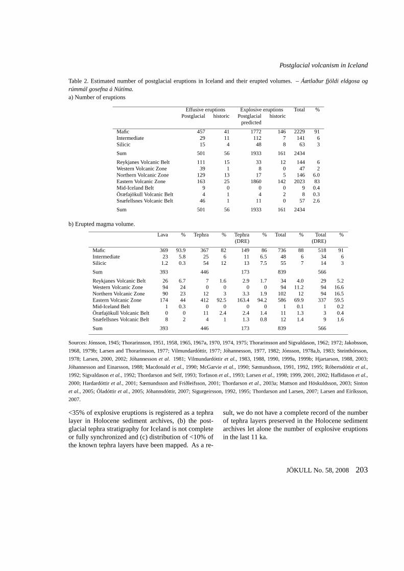
Table 2. Estimated number of postglacial eruptions in Iceland and their erupted volumes. –Áætlaður fjöldi eldgosa ogrúmmál gosefna á Nútíma.a) Number of eruptions
Effusive eruptions Explosive eruptions Total %Postglacial historic Postglacial historic
predicted
Mafic 457 41 1772 146 2229 91Intermediate 29 11 112 7 141 6Silicic 15 4 48 8 63 3
Sum 501 56 1933 161 2434
Reykjanes Volcanic Belt 111 15 33 12 144 6Western Volcanic Zone 39 1 8 0 47 2Northern Volcanic Zone 129 13 17 5 146 6.0Eastern Volcanic Zone 163 25 1860 142 2023 83Mid-Iceland Belt 9 0 0 0 9 0.4Öræfajökull Volcanic Belt 4 1 4 2 8 0.3Snæfellsnes Volcanic Belt 46 1 11 0 57 2.6
Sum 501 56 1933 161 2434
b) Erupted magma volume.
Lava % Tephra % Tephra % Total % Total %(DRE) (DRE)
Mafic 369 93.9 367 82 149 86 736 88 518 91Intermediate 23 5.8 25 6 11 6.5 48 6 34 6Silicic 1.2 0.3 54 12 13 7.5 55 7 14 3
Sum 393 446 173 839 566
Reykjanes Volcanic Belt 26 6.7 7 1.6 2.9 1.7 34 4.0 29 5.2Western Volcanic Zone 94 24 0 0 0 0 94 11.2 94 16.6Northern Volcanic Zone 90 23 12 3 3.3 1.9 102 12 94 16.5Eastern Volcanic Zone 174 44 412 92.5 163.4 94.2 586 69.9 337 59.5Mid-Iceland Belt 1 0.3 0 0 0 0 1 0.1 1 0.2Öræfajökull Volcanic Belt 0 0 11 2.4 2.4 1.4 11 1.3 3 0.4Snæfellsnes Volcanic Belt 8 2 4 1 1.3 0.8 12 1.4 9 1.6
Sum 393 446 173 839 566
Sources: Jónsson, 1945; Thorarinsson, 1951, 1958, 1965, 1967a, 1970, 1974, 1975; Thorarinsson and Sigvaldason, 1962;1972; Jakobsson,
1968, 1979b; Larsen and Thorarinsson, 1977; Vilmundardóttir, 1977; Jóhannesson, 1977, 1982; Jónsson, 1978a,b, 1983; Steinthórsson,
1978; Larsen, 2000, 2002; Jóhannessonet al. 1981; Vilmundardóttiret al., 1983, 1988, 1990, 1999a, 1999b; Hjartarson, 1988, 2003;
Jóhannesson and Einarsson, 1988; Macdonaldet al., 1990; McGarvieet al., 1990; Sæmundsson, 1991, 1992, 1995; Róbertsdóttiret al.,
1992; Sigvaldasonet al., 1992; Thordarson and Self, 1993; Torfasonet al., 1993; Larsenet al., 1998; 1999, 2001, 2002; Haflidasonet al.,
2000; Hardardóttiret al., 2001; Sæmundsson and Friðleifsson, 2001; Thordarsonet al., 2003a; Mattson and Höskuldsson, 2003; Sinton
et al., 2005; Óladóttiret al., 2005; Jóhannsdóttir, 2007; Sigurgeirsson, 1992, 1995; Thordarson and Larsen, 2007; Larsen and Eiríksson,
2007.
<35% of explosive eruptions is registered as a tephralayer in Holocene sediment archives, (b) the post-glacial tephra stratigraphy for Iceland is not completeor fully synchronized and (c) distribution of <10% ofthe known tephra layers have been mapped. As a re-
sult, we do not have a complete record of the numberof tephra layers preserved in the Holocene sedimentarchives let alone the number of explosive eruptionsin the last 11 ka.
JÖKULL No. 58, 2008 203
Th. Thordarson and Á. Höskuldsson
As expected, the record of explosive eruptions ismost comprehensive in historical times, especially inthe last 800 years (i.e. since AD 1200). The exist-ing record has been compiled from three types ofarchives: (a) tephra layers preserved in soil profilesacross the country, (b) layers in ice cores and ice ab-lation areas within the Vatnajökull Glacier, and (c) in-formation on eruptions contained in historical chron-icles. It indicates that∼156 explosive eruptions havetaken place in Iceland since 1200 AD, but only 57 areregistered as tephra layers in the post AD1200 soils(e.g. Thordarson and Larsen, 2007; Larsen and Eiríks-son, 2007).
The AD1200-AD2004 record is dominated by ac-tivity within the EVZ volcanic systems, which areresponsible for∼87% of the recorded events. Thesubglacial Grímsvötn volcano has been most active,with ∼47% of the events and∼22% (3.6 km3) ofthe magma output. The Bárðarbunga-Veiðivötn, Katlaand Hekla systems are accountable for∼15%,∼12%and ∼11% of events and∼15% (2.5 km3), ∼28%(4.6 km3) and 7% (1.2 km3) of the magma output.The remaining EVZ volcanic systems produced <3%of the explosive eruptions and∼6% (1 km3) of theerupted magma. Other volcanic zones collectively ac-count for∼13% of the events and∼22% (3.6 km3)of the magma output (e.g. Thordarson and Larsen,2007).
Despite the dominance of Grímsvötn and Bárðar-bunga volcanoes in the explosive eruption record,their activity has only produced 14 (<25%) out of 57tephra layers present in the post-AD1200 soils (e.g.Thorarinsson, 1967a; Larsen, 1979; 1982; Hafliða-sonet al., 2000; Thordarsonet al., 1998). The soilrecord is governed by the Katla and Hekla volcanoes,which have produced >55% of the tephra layers pre-served in the post-AD1200 soils. The simplest expla-nation of this differential representation is the remote-ness of Grímsvötn and Bárðarbunga and favourableposition of Katla and Hekla with respect to good soil-trap sites. Conversely, the tephra-in-ice record fromthe Vatnajökull ice-cap is dictated by the Grímsvötnand Bárðarbunga (Figure 1). About 88% of the tephralayers in the ice originate from these two volcanoes(Larsenet al., 1998).
The tephra capture frequency in post-AD1200 soilat any one site near the active volcanic zones is on theorder of 1–2 layers/100 yrs. However, the compositerecord compiled here indicates that collectively about7 tephra layers are incorporated into the soil cover inIceland per Century. This value compares favourablywith the first three Centuries of settlement, where to-tal of 18 layers imply a capture rate of 6 layers/100yrs. Thus, collectively the historic soils register <1/3of the actual number of explosive eruptions. This in-formation is important for assessment of number ofprehistoric explosive eruptions, because the on-landtephra stratigraphy is the principal data archive. Ac-cordingly, the prehistoric tephra stratigraphy is likelyto underestimate the number of explosive eruptions inIceland by a factor of∼3.
The prehistoric tephra record in Iceland is im-pressive and has been measured in thousands of soilprofiles across the country (e.g. Thorarinsson, 1958,1967a) and steadily improved over the last 30 years byvarious studies. Nonetheless, majority of publishedrecords only extend back to H3 ( 3 ka) or H4 ( 4.2ka) or H5 (∼7 ka) times (Larsen, 1979, 1984, 2002;Jóhannessonet al. 1981; Róbertsdóttiret al., 2092;Boygle, 1999; Larsenet al. 2001, 2002; Hardardóttiret al., 2001). Only a handful of measured sectionsextend beyond 8 ka (e.g. Sæmundsson, 1991; Larsen,2000; Óladóttiret al., 2005). However, recent stud-ies of the tephra succession in lake sediments haveextended the record beyond 10 ka (e.g. Jóhannsdóttir,2007). Offshore marine sediment- and Greenland Ice-cores extend the record even further back in time al-though much fewer events are preserved at these far-field sites (e.g. Haflidasonet al., 2000; Jenningset al.2002; Larsenet al., 2002; Kristjánsdóttiret al., 2007).
Despite the existence of extensive records for thelast 7 ka in all parts of the country, the total tally ofexplosive eruptions represented by the tephra layersin these archives is still uncertain. The most completerecords exist closest to the active volcanic zones, es-pecially near the EVZ (Figure 3a). The soils in theÁlftaver highland pasture, South Central Iceland (site1 on Figure 3a), preserve a record extending back to∼8.5 ka, containing about 208 tephra layers, indicat-ing a capture of∼2.5 layers/100 years (Óladóttiret
204 JÖKULL No. 58, 2008
Postglacial volcanism in Iceland
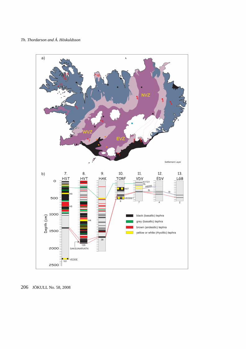
al., 2005; 2008). Further east, at sites 2 and 3,∼7ka-long records contains 73 and 25 layers, or 1 and0.4 layers/100 yrs, respectively (Thorarinsson, 1958).Similarly long records at sites 4, 5 and 6 in the interiorof North and East Iceland contain 67, 20, 11 layerseach, indicating a capture of 1 to 0.2 layers per Cen-tury (Thorarinsson, 1958; Larsenet al., 2002). Thetephra layer capture rate in 3–7 ka-long records alongthe western edge of the EVZ is∼1 tephra layer perCentury (range 0.3–1.5; Thorarinsson, 1967a; Larsen,1979), whereas in the lake sediment archive at sites 7and 8, extending back to≤11 ka, the rate is 1.3–1.6layer/100 yrs (e.g. Jóhannsdóttir, 2007). Further to theNW (i.e. sites 9 to 13 on Figure 3a), the capture rateis∼0.4 to∼0.02 layers per 100 yrs. This informationshows that the prehistoric tephra capture rate at sitesnear the active volcanic zones is comparable to that ofhistoric time. It also shows that the capture rate dropsoff abruptly with increasing distance from the activevolcanic zones (Figure 3b).
Sites 1, 4, 7, and 8 contain the most comprehen-sive tephra record and individually exhibit capture fre-quencies of 1 to 2.5 layer/100yrs. These records arelikely to be complementary because of their relativeposition to the most active tephra producing volca-noes (see below). Their collective capture rate is∼6.5layers/100 yrs or identical to that obtained for histor-ical soils. This suggests that the overall pattern ofprehistoric explosive volcanism in Iceland was sim-ilar to that of the last 800 years, although the eruptionpattern of individual central volcanoes changed some-what from time to time. Furthermore, chemical analy-sis of the tephra succession at sites 7 and 8, which in-dicate that >95% of the post-glacial tephra layers orig-inated from the EVZ volcanoes, Grímsvötn, Bárðar-bunga, Katla and Hekla. It also shows that Katla andHekla layers dominate the record, primarily becauseof these volcanoes are closest to these sites (Figure3a). This conjecture can be used, along with exist-ing data on the prehistoric tephra layers, as a templateto estimate the total number of post-glacial explo-sive eruptions in Iceland as well as their cumulativemagma output volumes. These estimates are given inTable 2, along with their likely distribution among theactive volcanic zones.
If we take the numbers derived above at facevalue, a 6.5 layer per century capture rate indicatesthat the post-glacial soil and lake sediment archivesin Iceland should contain >700 tephra layers. Asthe preserved tephra layers only correspond to one-third of the actual events, the total number of explo-sive eruptions in Iceland over the last 11 ka shouldbe about 2000 events, which brings the total tally ofpost-glacial eruptions to just over 2400 events (Table2) This figure corresponds to 22 events per Century,which is similar to the eruption frequency obtainedby previous studies (Thorarinsson and Sæmundsson,1979; Thorarinsson, 1981a). However, this assess-ment includes number of assumptions with high de-gree of uncertainty. It also presupposes a steady statefor the activity over a period of 11 ka, which in thecontext of our knowledge of Icelandic volcanoes maybe an oversimplification. By the same token, the totalDRE volume of tephra produced is∼173±50 km3,indicating a total magma output of∼566±100 km3
for the post-glacial period. This figure suggests an av-erage postglacial output rate of∼5 km3 per Century,which is lower than the 8 km3 per Century obtainedfor historic time by Thordarson and Larsen (2007) bya factor∼1.6. However, it is still significantly higherthan the output rate of Hawaiian volcanoes, whichis estimated at∼3.6 km3 (range, 2.1-4.3 km3) perCentury (e.g. Swanson, 1972; Dvorak and Dzurisin,1993). This magma output (5 km3/100 yrs) is about33% and 5% of the inferred peak output rate for theColumbia River Basalt Group and the Deccan trapsflood basalt provinces (Tolanet al., 1989; Selfet al.,2006). Note, that these output figures given here areminimum values for the magma productivity at all ofthese provinces, because they do not account for thevolume of non-erupted magma stored in lithosphericintrusions. Their productivity is likely to double oreven triple if intrusive volumes are included (e.g. Dvo-rak and Dzurisin, 1993).
ERUPTION TYPES AND STYLESLava-producing eruptions in Iceland occur at mono-genetic point-source and fissure type volcanoes aswell as central volcanoes where such eruptions typ-ically take place on caldera ring fractures or radial
JÖKULL No. 58, 2008 205
Th. Thordarson and Á. Höskuldsson
EVZ
NVZ
WVZ
1
2
45
6
7
8
9
11
12
1310
3
9.
HAK
8.
HVT
7.
HST
10.
TORF
13.
LGB
12.
EDV
11.
VDV0
500
1000
1500
2000
2500
Depth
(cm
) black (basaltic) tephra
brown (andesitic) tephra
yellow or white (rhyolitic) tephra
grey (basaltic) tephra
a)
b)
VEDDE161
129
38
9 7 4 2
VEDDE?
SAKSUNARVATN
H4?
SL
tbtb
H5
H4
H4
H6000
Settlement Layer
K1721
206 JÖKULL No. 58, 2008
Postglacial volcanism in Iceland
Figure 3. (a) Sites of selected postglacial tephra sectionsin Iceland: 1. Álftavatnsafréttur (Larsen, 2000; Óla-dóttir et al., 2005), 2. Núpstaðarskógur, 3. Bæjarstaðarskógur, 4. Svartárkot, 5. Brú, 6. Hallormstaður (Thor-arinsson, 1958), 7. Hestvatn, 8. Hvítárvatn, 9. Haukadalsvatn, 10. Torfadalsvatn, 11. Vatnsdalsvatn, 12. Efs-tadalsvatn, 13. Laugabólsvatn (Thordarson et al., 2005; Jóhannsdóttir, 2007). (b) Change in number of tephralayers in soils with distance from active volcanic zones. The numbers at the top of each column refer to sitesshown on the map in (a) and figures at the base indicate number of tephra layers in each section. Position of theSettlement layer is indicated by green connectors and the Saksunarvatn tephra horizon by the red connectors;tb, tephra layer of transitional basalt composition; H6000, Hekla tephra layer of intermediate composition andapproximately 6000 years old. Both layers represent usefulmarker horizons in the Holocene sediments acrossVestfirðir peninsula. –(a) Staðsetning valdra gjóskusniða á Íslandi: 1. Álftavatnsafréttur, 2. Núpstaðarskógur,3. Bæjarstaðarskógur, 4. Svartárkot, 5. Brú, 6. Hallormstaður, 7. Hestvatn, 8. Hvítárvatn, 9. Haukadalsvatn,10. Torfadalsvatn, 11. Vatnsdalsvatn, 12. Efstadalsvatn,13. Laugabólsvatn. (b) Breytingar a fjölda varðveittragjóskulaga í jarðvegi með fjarlægð frá gosbeltum. Númerin ofan við hvert snið visa í staðsetningar á kortinu ámynd 3a og þau sem eru undir gefa til kynna fjölda gjóskulaga íhverju sniði.
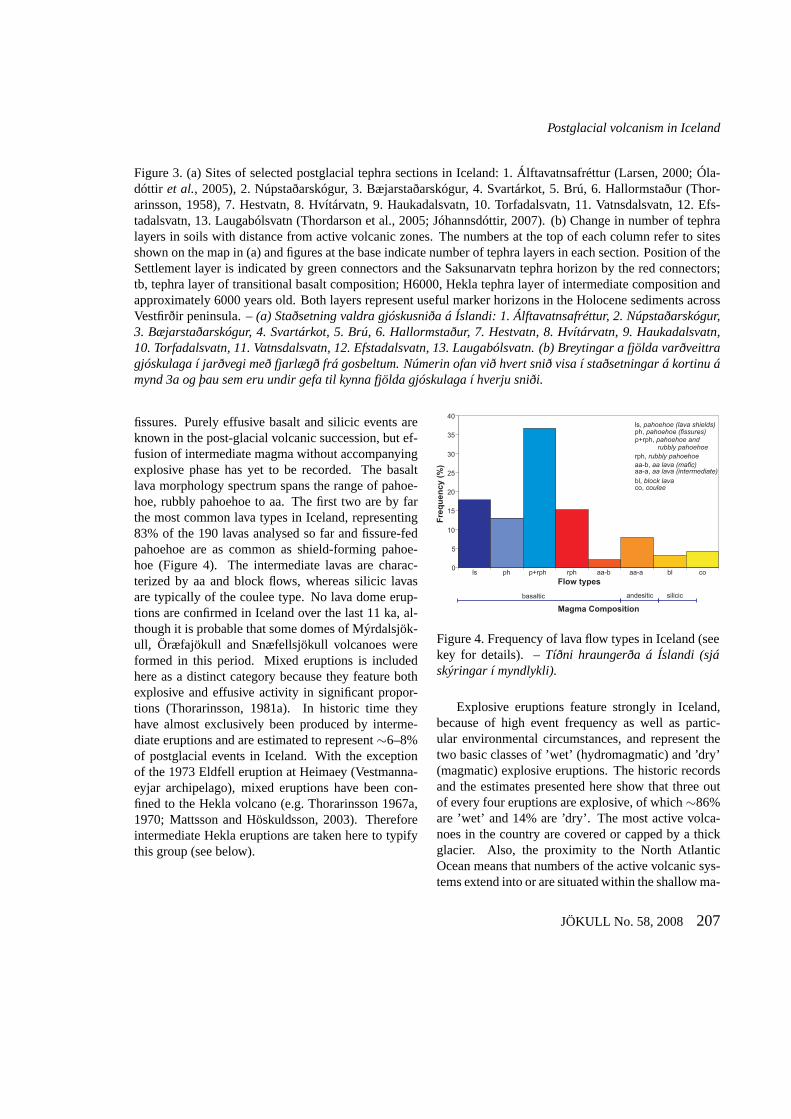
fissures. Purely effusive basalt and silicic events areknown in the post-glacial volcanic succession, but ef-fusion of intermediate magma without accompanyingexplosive phase has yet to be recorded. The basaltlava morphology spectrum spans the range of pahoe-hoe, rubbly pahoehoe to aa. The first two are by farthe most common lava types in Iceland, representing83% of the 190 lavas analysed so far and fissure-fedpahoehoe are as common as shield-forming pahoe-hoe (Figure 4). The intermediate lavas are charac-terized by aa and block flows, whereas silicic lavasare typically of the coulee type. No lava dome erup-tions are confirmed in Iceland over the last 11 ka, al-though it is probable that some domes of Mýrdalsjök-ull, Öræfajökull and Snæfellsjökull volcanoes wereformed in this period. Mixed eruptions is includedhere as a distinct category because they feature bothexplosive and effusive activity in significant propor-tions (Thorarinsson, 1981a). In historic time theyhave almost exclusively been produced by interme-diate eruptions and are estimated to represent∼6–8%of postglacial events in Iceland. With the exceptionof the 1973 Eldfell eruption at Heimaey (Vestmanna-eyjar archipelago), mixed eruptions have been con-fined to the Hekla volcano (e.g. Thorarinsson 1967a,1970; Mattsson and Höskuldsson, 2003). Thereforeintermediate Hekla eruptions are taken here to typifythis group (see below).
0
5
10
15
20
25
30
35
40
ls
ls, lava shields)pahoehoe (
ph
ph, pahoehoe (fissures)
p+rph
p+rph, pahoehoe andrubbly pahoehoe
rph
rph, rubbly pahoehoe
aa-b
aa-b, aa lava (mafic)
basaltic
aa-a
aa-a, aa lava (intermediate)
bl
bl, block lava
co
co, coulee
Magma Composition
Fre
qu
en
cy (
%)
Flow types
andesitic silicic
Figure 4. Frequency of lava flow types in Iceland (seekey for details). –Tíðni hraungerða á Íslandi (sjáskýringar í myndlykli).
Explosive eruptions feature strongly in Iceland,because of high event frequency as well as partic-ular environmental circumstances, and represent thetwo basic classes of ’wet’ (hydromagmatic) and ’dry’(magmatic) explosive eruptions. The historic recordsand the estimates presented here show that three outof every four eruptions are explosive, of which∼86%are ’wet’ and 14% are ’dry’. The most active volca-noes in the country are covered or capped by a thickglacier. Also, the proximity to the North AtlanticOcean means that numbers of the active volcanic sys-tems extend into or are situated within the shallow ma-
JÖKULL No. 58, 2008 207
Th. Thordarson and Á. Höskuldsson
vents
lava pathway
Lava flow 1
lava flow 2
Lava Flow Fieldflow lobes
(sheet lobes)
active flow front
b) insulated pathway
d) pahoehoe
c) open channel
lava pathways
a)
active flow front
e) aa
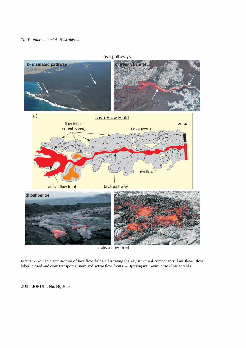
Figure 5. Volcanic architecture of lava flow fields, illustrating the key structural components: lava flows, flowlobes, closed and open transport system and active flow fronts. –Byggingareinkenni basalthraunbreiða.
208 JÖKULL No. 58, 2008
Postglacial volcanism in Iceland
rine environment. In addition, the land is wet becauseof high groundwater level induced by widespread andimpermeable glacial deposits in the regolith. Thisabundant availability of H2O at the surface explainsthe dominance of ’wet’ eruptions and the elevated ex-plosivity of mafic eruptions (>90% of all explosiveevents are mafic), which otherwise would be effusiveor weakly explosive as exemplified by the postglacialactivity on the RVB, WVZ and NVZ. Thus, it is nosurprise that mafic explosive eruptions have becomeIceland’s trademark events as exemplified by the well-publicised eruption of Surtsey in 1963-67 (e.g. Thor-arinsson, 1967b, 1967c; Walker, 1973b) and recentmafic activity at the ice-covered Grímsvötn volcano(e.g. Guðmundssonet al. 1997, 2002; Sigmundssonand Guðmundsson, 2004).
Silicic explosive eruptions in Iceland are confinedto central volcanoes and in post-glacial time theyhave produced about 58 tephra layers (e.g. Larsen andEiríksson, 2007). The existing record is noteworthy,indicating an event frequency of∼1 eruption every200–300 years and approaches that observed at thehighly active silicic systems such as the Taupo Vol-canic Zone in New Zealand (e.g. Houghtonet al.,1995). The recurrence frequency of large events issignificantly lower, or one eruption every 1000 yearsfor events in the volume bracket of 1–10 km3 oftephra, (0.25–2.5 km3 DRE) and roughly one every100.000 years for events >10 km3 tephra (>2.5 km3
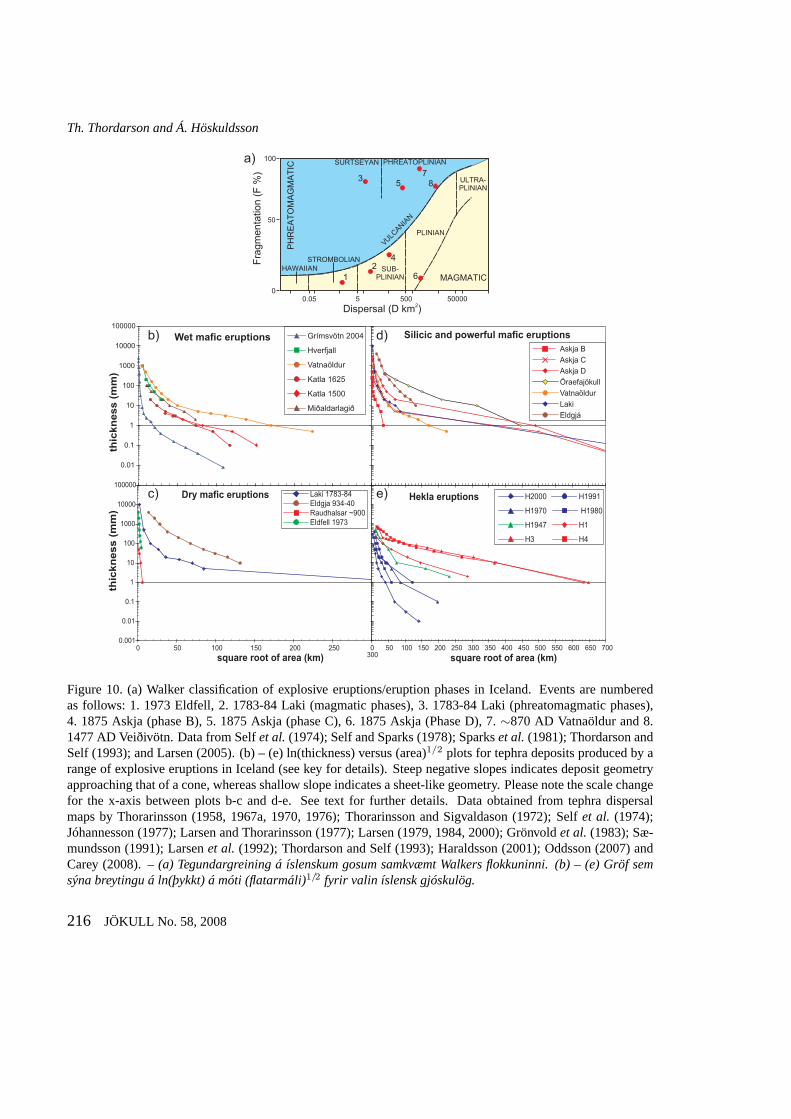
DRE; Lacasse and Garbe-Schönberg, 2001; Thord-arson and Larsen 2007). Silicic events are catego-rized as ’dry’ (2.5% of all explosive events) and ’wet’(1.4%) eruptions. Both types have occurred at ice-free and glacier-covered volcanoes. Although, quan-titative classification schemes for explosive eruptionshave been introduced, first by Walker (1973b) andlater by Pyle (1989) and widely used (e.g. Cas andWright, 1987; Francis and Oppenheimer, 2004), theseschemes have generally not been applied to Icelandiceruptions. For example, Walker indices have onlybeen calculated for a handful of events and Pyle in-dices have only been produced for one event (Pyle,1989). The main reasons for this shortage are lackof adequate grain size data as well as dearth of pub-lished good quality isopach and isopleth maps. As a
result, styles of explosive eruptions in Iceland havebeen inferred on the basis of qualitative observationsof the events and/or nature of their fall deposits. Al-though the grouping of explosive eruptions presentedbelow is marked by these deficiencies, we have in-cluded ln(thickness) - (isopach area)1/2 plots for sev-eral events to provide some quantification of and com-parative information on the relevant explosive erup-tion styles, (see below).
EFFUSIVE ERUPTIONSMafic lava-producing eruptions are the building-blocks of Iceland and represent an assorted class ofevents that span a wide spectrum in terms of eruptionstyle and magnitude. They occur on all of the ventsystem types mentioned above and individual erup-tions can feature styles ranging from passive lava ef-fusion to vigorous fountains to explosive phases ofsubplinian intensities. In terms of erupted magma vol-umes, they span the range from 1 m3 to 25 km3 (e.g.Thordarson and Larsen, 2007). For purpose of de-scription, we divide effusive eruptions into small tomedium (<1 km3) and large (≥1 km3) volume events,where each involves a spectrum of eruption behaviourrepresented here by low- and high-magma dischargeend-member types.
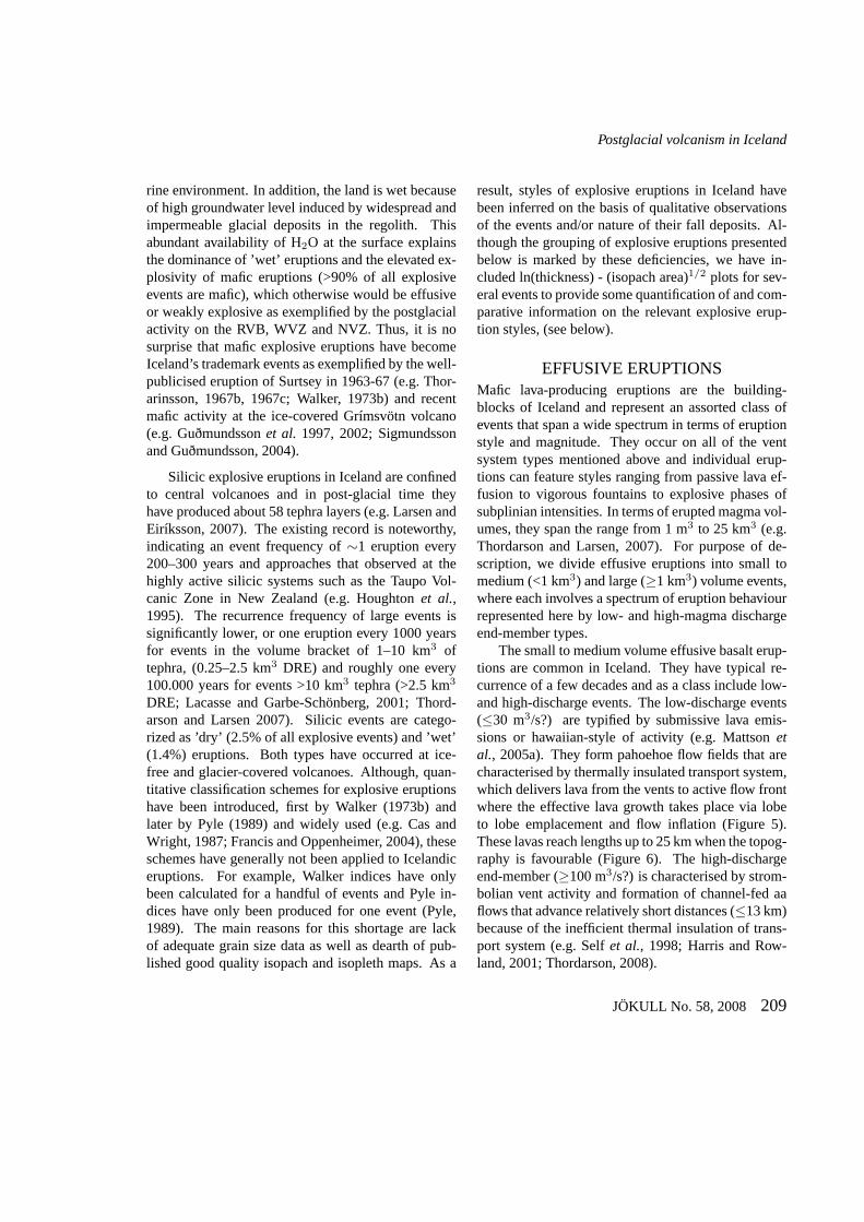
The small to medium volume effusive basalt erup-tions are common in Iceland. They have typical re-currence of a few decades and as a class include low-and high-discharge events. The low-discharge events(≤30 m3/s?) are typified by submissive lava emis-sions or hawaiian-style of activity (e.g. Mattsonetal., 2005a). They form pahoehoe flow fields that arecharacterised by thermally insulated transport system,which delivers lava from the vents to active flow frontwhere the effective lava growth takes place via lobeto lobe emplacement and flow inflation (Figure 5).These lavas reach lengths up to 25 km when the topog-raphy is favourable (Figure 6). The high-dischargeend-member (≥100 m3/s?) is characterised by strom-bolian vent activity and formation of channel-fed aaflows that advance relatively short distances (≤13 km)because of the inefficient thermal insulation of trans-port system (e.g. Selfet al., 1998; Harris and Row-land, 2001; Thordarson, 2008).
JÖKULL No. 58, 2008 209
Th. Thordarson and Á. Höskuldsson
0
1
10
100
1000
0 5 10 15 20 25 30
Flow field volume (km )3
Flo
w len
gth
(km
)
ls
ph
ph+rph
rph
aa-b
aa-a
bl
co
0
1
10
100
0.0 0.2 0.4 0.6 0.8 1.0
Figure 6. Plot showing length versus volume for Icelandic lava flow fields. Abbreviations are as follows: ls,pahoehoe (lava shield eruptions), ph, pahoehoe (fissure eruptions), ph+rph, pahoehoe and rubbly pahoehoe,rph, rubbly pahoehoe, aa-b, aa lava (mafic), aa-a, aa lava (intermediate), bl, block lava, co, coulee. –Graf semsýnir tengslin á milli lengdar og rúmmáls íslenskra hrauna.Skammstafanir: ls, helluhraun (hraunskildir), ph,helluhraun (sprungugos), ph+rph, hellu- og klumpahraun, rph, klumpahraun, aa-b, apalhraun (basalt), aa-a,apalhraun (ísúrt), bl, blakkarhraun, co, stokkahraun.
A special class among these high-discharge andsmall-volume mafic eruptions are events that haveproduced, concurrent with fountain-fed lava flows,rather extensive welded and rheomorphic spatteraprons that mantle the landscape around the sourcevents (Karlunhen, 1988; Calderoneet al., 1990; Sæ-mundsson, 1991). A good example of these stunningvolcaniclastic deposits is the∼4000 ka Biskupsfellformation (∼0.038 km3) from the Kverkfjöll volcanicsystem. The lava fountains of the Biskupsfell eruptionformed a rheomorphic apron that blanketed the Pleis-tocene pillow lava ridge topography up to 1.5 km fromthe source fissure and supplied fountain-fed flows thatreached length of∼5 km.
Effusive eruptions typified by intermittent hawai-ian and strombolian phases as well as pulsating dis-charge form rubbly pahoehoe flow fields. Judging
from frequency distribution of flow types, this hybridclass appears to be the most common style of effusiveeruption in Iceland (e.g. Guilbaud, 2006; Thordarson,2008).
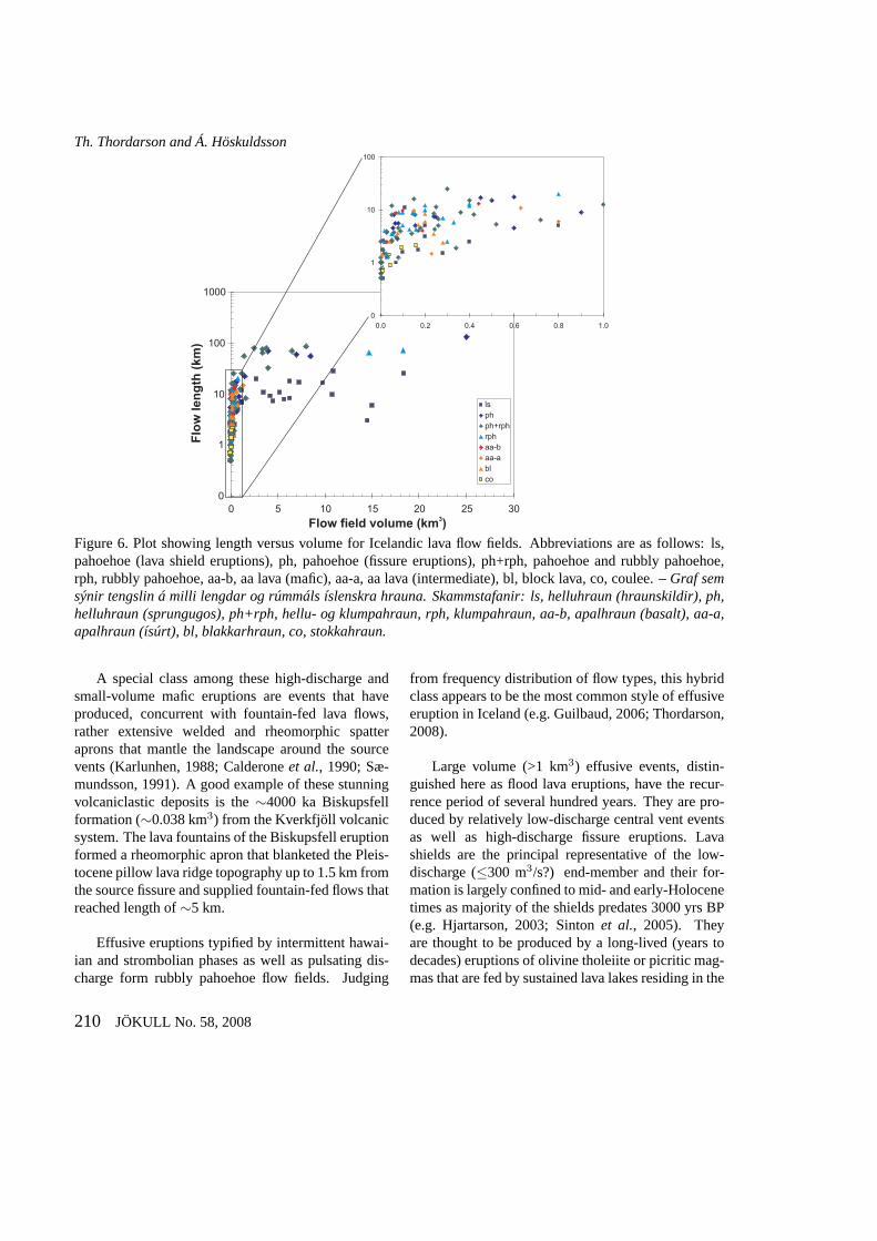
Large volume (>1 km3) effusive events, distin-guished here as flood lava eruptions, have the recur-rence period of several hundred years. They are pro-duced by relatively low-discharge central vent eventsas well as high-discharge fissure eruptions. Lavashields are the principal representative of the low-discharge (≤300 m3/s?) end-member and their for-mation is largely confined to mid- and early-Holocenetimes as majority of the shields predates 3000 yrs BP(e.g. Hjartarson, 2003; Sintonet al., 2005). Theyare thought to be produced by a long-lived (years todecades) eruptions of olivine tholeiite or picritic mag-mas that are fed by sustained lava lakes residing in the
210 JÖKULL No. 58, 2008
Postglacial volcanism in Iceland
fountain-fedsheet flow
lava coneslope angle, 6°-9°
slope angle <3°slope angle, 3 -9° °
slope angle <2°
tuff cone
lava cone
lava apronactive flow front
a)
internallava pathway
fountaininglava pond
subdudelava pond
b)
200
400600
5 km
900
1100
1300
1500
H = 3xL
Þeistareykjarbunga; type A Trölladyngja; type Bc)
Figure 7. Growth stages of lava shields (a) the lava cone stage and (b) lava apron stage. (c) profiles of type A andB lava shields. See text for further details. –Vaxtarstig hraunskjalda: (a) hraunkeilustig og (b) hraunsvuntustig.(c) Þversnið af A og B gerðum hraunskjalda.
summit vent. They often, especially the olivine tholei-ite events, produce vast pahoehoe flow fields that haveradius (i.e. flow length) up to 28 km and volumes ap-proaching 20 km3 (Figure 6). Lava shields often formremarkably symmetrical volcanoes, where a lava conewith summit crater and gently sloping (3–10◦) outerflanks is circumscribed by a lava apron with surfaceslope of 0.5–2◦ (e.g. Rossi, 1996). Study by Thordar-son and Sigmarsson (2008) indicates that lava conesand aprons are formed in sequence rather than syn-chronously. The lava cones are constructed first, dur-ing periods of relatively high magma discharge andvigorous lava lake activity producing surface flows.The lava aprons are formed subsequently, when thedischarge is low (<50 m3/s?) and lava is fed passivelythrough internal pathways from the source vent to ac-tive flow fronts out in the flow field. The lava cone isessentially constructed by overbank and fountain-fedsurface flows that exhibit a distinct lava facies associ-ation characterized by shelly pahoehoe in the proxim-ity of the vent and slabby pahoehoe and aa sheet flowsin the more distal sectors (Figure 7a). The surround-ing lava apron is produced by insulated transport toactive flow fronts where growth takes place by lobeto lobe emplacement and flow inflation (Figure 7b).The characteristic facies association of the apron ishummocky pahoehoe featuring tumuli, lava-rise pitsand flat-topped sheet lobes (e.g. Walker, 1991; Rossi,1996; Thordarson, 2000a).
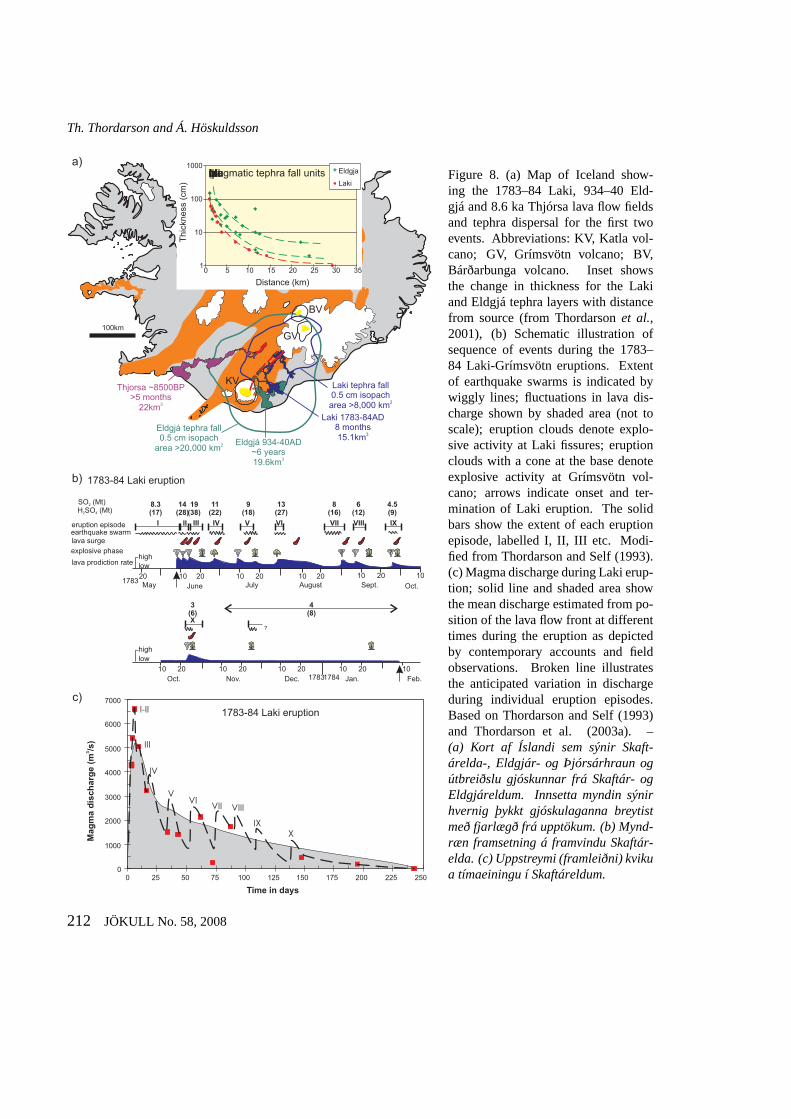
Lava shields in Iceland are typified by a spectrumof profiles that fall between two end-member types:(A) very low profile shields with <2◦ sloping flanksand large lava apron and (B) shields with slope an-gles >3◦, a steepening summit-terminus profile and awell-defined, proportionally large volume lava cone(Figure 7c). Type A shields are thought to be con-structed by steady, low-discharge eruptions with min-imal surface flow activity, whereas type B shieldsare formed by eruptions supporting prolonged peri-ods of relatively high-discharge and fountain-fed sur-face flows. It has been proposed that type B shieldswith proportionally large lava cones, such as Sk-jaldbreið and Trölladyngja, were formed by rela-tively high-discharge events (>50 m3/s?) with sus-tained surface flow activity and eruption duration ofyears to decades. Conversely, low profile type Ashields, such as Þeistareykjarbunga, were formed bylow and steady effusion of lava during eruptions thatlasted for decades to centuries in case of the biggestshields (Thordarson and Sigmarsson, 2008). Thehigh-discharge (>1000 m3/s) flood lava events aremost common on, but not exclusive to, the EVZ andare some of the best studied manifestation of Ice-landic volcanism (e.g. Vilmundardóttir, 1977; Lar-sen, 1979, 2000; Hjartarson, 1988; Thordarson andSelf, 1993; Thordarsonet al., 2001; Thordarson andLarsen, 2007). They include the 1783–1784 ADLaki (15.1 km3), 934–940 AD Eldgjá (19.6 km3) and∼8600 years BP Thjórsá (25 km3) fissure eruptions
JÖKULL No. 58, 2008 211
Th. Thordarson and Á. Höskuldsson
Laki tephra fall0.5 cm isopacharea >8,000 km2
Eldgjá tephra fall0.5 cm isopach
area >20,000 km2
100km
BV
GV
KV
Laki 1783-84AD8 months15.1km3
Eldgjá 934-40AD~6 years19.6km3
Thjorsa ~8500BP>5 months
22km3
1783
17841783
1010 10 10 10
10 10 10 10 1020 20 20 20
20 20 20 20 20May June July August Sept.
Nov. Dec. Jan. Feb.
Oct.
eruption episode
SO (Mt)2
H SO (Mt)2 4
explosive phase
lava surge
lava prodiction rate
earthquake swarm
lowhigh
highlow
II
8.3(17)
14(28)
19(38)
11(22)
9(18)
13(27)
8(16)
6(12)
4.5(9)
3(6)
4(8)
III IV V VI VII VIII IX
X?
I
?
?
? ?
Oct.
a)
b)
1
10
100
1000
0 5 10 15 20 25 30 35
Distance (km)
Thic
kness
(cm
)Eldgja
LakiMagmatic tephra fall units
1783-84 Laki eruption
1783-84 Laki eruption
0
1000
2000
3000
4000
5000
6000
7000
0 25 50 75 100 125 150 175 200 225 250
Time in days
Ma
gm
a d
isc
ha
rge
(m
/s)
3
I-II
III
IV
VVI
VII VIII
IX
X
c)
Figure 8. (a) Map of Iceland show-ing the 1783–84 Laki, 934–40 Eld-gjá and 8.6 ka Thjórsa lava flow fieldsand tephra dispersal for the first twoevents. Abbreviations: KV, Katla vol-cano; GV, Grímsvötn volcano; BV,Bárðarbunga volcano. Inset showsthe change in thickness for the Lakiand Eldgjá tephra layers with distancefrom source (from Thordarsonet al.,2001), (b) Schematic illustration ofsequence of events during the 1783–84 Laki-Grímsvötn eruptions. Extentof earthquake swarms is indicated bywiggly lines; fluctuations in lava dis-charge shown by shaded area (not toscale); eruption clouds denote explo-sive activity at Laki fissures; eruptionclouds with a cone at the base denoteexplosive activity at Grímsvötn vol-cano; arrows indicate onset and ter-mination of Laki eruption. The solidbars show the extent of each eruptionepisode, labelled I, II, III etc. Modi-fied from Thordarson and Self (1993).(c) Magma discharge during Laki erup-tion; solid line and shaded area showthe mean discharge estimated from po-sition of the lava flow front at differenttimes during the eruption as depictedby contemporary accounts and fieldobservations. Broken line illustratesthe anticipated variation in dischargeduring individual eruption episodes.Based on Thordarson and Self (1993)and Thordarson et al. (2003a). –(a) Kort af Íslandi sem sýnir Skaft-árelda-, Eldgjár- og Þjórsárhraun ogútbreiðslu gjóskunnar frá Skaftár- ogEldgjáreldum. Innsetta myndin sýnirhvernig þykkt gjóskulaganna breytistmeð fjarlægð frá upptökum. (b) Mynd-ræn framsetning á framvindu Skaftár-elda. (c) Uppstreymi (framleiðni) kvikua tímaeiningu í Skaftáreldum.
212 JÖKULL No. 58, 2008
Postglacial volcanism in Iceland
(Figure 8a), which have produced the longest lavaflows in Iceland (65–130 km) and represent some ofthe largest flood lava events on Earth in post-glacialtime. Recent studies, especially those focused onthe Laki event (e.g. Thordarsonet al., 1996, 2003a;Keszthelyi et al, 2000, 2004, Guilbaudet al., 2005,2007), have played an important role in enhancingour understanding of flood basalt eruptions and theirpotential environmental and climatic effects (e.g. Selfet al., 1996, 1997, 1998, 2006; Thordarson and Self,1996, 1998; Keszthelyi and Self, 1998). In Iceland,the flood lava events take place on 10’s of km longlinear vent system demarked by a row of often tightlypacked cratered cones that delineate multiple fissuresegments arranged in an en echelon fashion. Theflood lava events are prolonged eruptions that lastfor months to years and feature numerous eruptionepisodes (Figure 8b). Each episode appears to repre-sent a rifting event (i.e. formation of a new fissure) andbegins with a short-lived explosive phase followedby a longer phase of lava emissions. The explosivephases at the beginning of each episode last for hoursto days and coincide with times of peak magma dis-charge of∼6–7000 m3/s (Figure 8c). They are typi-fied by magmatic and phreatomagmatic phases of sub-plinian intensities that produce widespread tephra lay-ers of substantial volumes. For example, the 934–940 Eldgjá event formed a tephra layer that covers>20,000 km2 within the 0.5 cm isopach and has a vol-ume of∼1.2 km3 DRE or∼5 km3 freshly fallen (Fig-ure 8a; Larsen, 2000). The subsequent effusive phasefeatures relatively quiet effusion of lava at more mod-erate (1000–3000 m3/s) and steadily declining dis-charge (Figure 8b). The flood lava flow fields con-sist of pahoehoe and rubbly pahoehoe (or platy-ridgelava), signifying insulated transport, growth by infla-tion and break-up of the original pahoehoe to formrubbly flows brought about by the highly fluctuatingdischarge (e.g. Keszthelyiet al., 2000, 2004; Thord-arsonet al., 2003a; Guilbaudet al., 2005).
Effusive silicic eruptions are relatively rare occur-rence in the Holocene and generally have producedsmall volume (<0.2 km3) subaerial block lavas andcoulees (Sæmundsson, 1972; Blake, 1984; Macdon-ald et al., 1990; McGarvieet al., 1990; Sæmunds-
son and Fridleifsson, 2001). Silicic lavas in Icelandare characterized by aspect ratios of 0.02–0.05, whichis very low compared to the typical aspect ratio of∼0.1 for the same flow types in other volcanic re-gions (Walker, 1973a). The low aspect ratio of theIcelandic lavas is though to reflect their relatively high(900–1000◦C) eruption temperature and low viscosity(∼105–106 Pa s).
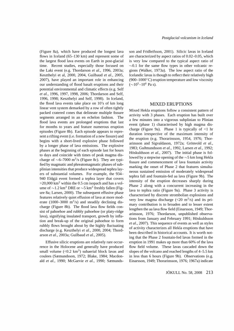
MIXED ERUPTIONSMixed Hekla eruptions follow a consistent pattern ofactivity with 3 phases. Each eruption has built overa few minutes into a vigorous subplinian to Plinianevent (phase 1) characterised by high magma dis-charge (Figure 9a). Phase 1 is typically of <1 hrduration irrespective of the maximum intensity ofthe eruption (e.g. Thorarinsson, 1954, 1976; Thor-arinsson and Sigvaldason, 1972a; Grönvoldet al.,1983; Guðmundssonet al., 1992, Larsenet al., 1992;Höskuldssonet al., 2007). The initial phase is fol-lowed by a stepwise opening of the∼5 km long Heklafissure and commencement of lava fountain activitymarking the onset of Phase 2 that features simulta-neous sustained emission of moderately widespreadtephra fall and fountain-fed aa lava (Figure 9b). Theintensity of the eruption decreases sharply duringPhase 2 along with a concurrent increasing in thelava to tephra ratio (Figure 9a). Phase 3 activity ischaracterised by discrete strombolian explosions andvery low magma discharge (<20 m3/s) and its pri-mary contribution is to broaden and to lesser extentlengthen the aa lava flow field (Einarsson, 1949; Thor-arinsson, 1976; Thordarson, unpublished observa-tions from January and February 1991; Höskuldssonet al., 2007). This sequence of events as well as stylesof activity characterizes all Hekla eruptions that havebeen described in historical accounts. It is worth not-ing that the Phase 2 fountain-fed lavas formed in theeruption in 1991 makes up more than 60% of the lavaflow field volume. These lavas cascaded down theslopes of the volcano and reached lengths of 4–5.5 kmin less than 6 hours (Figure 9b). Observations (e.g.Einarsson, 1949; Thorarinsson, 1976; 1967a) indicate
JÖKULL No. 58, 2008 213
Th. Thordarson and Á. Höskuldsson
January
Plinian tephra
fountain-fed lava/tephra
‘normal’ lava
20002000
1000
30003000
70
60
50
40
20
10
0
0
0
0
10 20
530
30 40 50
February March
Eru
ptio
n r
ate
(m
/se
c)3
Eru
ptio
n r
ate
(m
/se
c)3
First 5 days of eruption
a)
1000
800
800
1000
600
400
1200
Sudurbjallar
Vatnafjoll
19 40’o
19 40’o
64o64o
East cone (phase 3 vent)
2km
Axlargigur (phase 1 vent)
fissures ( )phase 2
fountain-fed lava( )period of high discharge
‘normal’ lava( e)period of low discharg
Hekla volcano
b)
Figure 9. (a) Magma discharge versus time during the 1991 Hekla eruption including that of phases 1, 2, and3 during first 5 days of the eruption (inset). (b) Map showing the 1991 Hekla vent system, main tephra fallsectors during phases 1 and 2 of the eruption as well as the distribution of Phase 2 fountain-fed and Phase 3‘normal’ lava flows. Based on Gudmundssonet al.(1992) and supplemented by unpubl. data by T. Thordarson,2008. –(a) Uppstreymi (framleiðni) kviku a tímaeiningu í Heklugosinu 1991. (b) Kort af gígum og hraunumfrá Heklugosinu 1991.
214 JÖKULL No. 58, 2008
Postglacial volcanism in Iceland
similar behaviour in other historic Hekla eruptions,suggesting that Phase 2-like activity can produce rela-tively long and perceivably hazardous fountain-fed aaflows in a short period of time.
WET EXPLOSIVE ERUPTIONS’Wet’ explosive eruptions in Iceland straddle the in-terface of water/ice and subaerial environments andare typified by three elementary styles, which inorder of increasing eruption intensity are: phreatic,phreatomagmatic and phreatoplinian (Figure 10a).With the exception of phreatic eruptions (see below),they involve physical interaction of the emergingmagma with non-magmatic water, which greatly en-hances their explosive power. The efficiency (power)of the explosive interaction depends principally on thewater to magma mass ratio (e.g. Wohletz, 1983; 1986;Morrisseyet al., 2000), but other variables are alsoimportant because the process of eruption involvesseveral interlinked mechanisms such as magma frag-mentation and detonation, expulsion (jetting) of solid-steam mixture, as well as transport and deposition ofthe solid products. The ’wet’ mafic eruptions are sig-nificantly more vigorous than their ’dry’ counterparts,whereas the silicic members are typically highly ex-plosive although their intensity is dependent on theexact eruption condition (e.g. Thorarinsson, 1967c,White and Houghton, 2000; Houghtonet al., 2000;Carey, 2008). Phreatic eruptions are relatively rare inIceland, registering 0.5% of explosive events. Sub-glacial phreatomagmatic eruptions (75%) dominatethe explosive event record, whereas the submarineand subaerial equivalents account for∼6% and 0.5%each. The phreatoplinian eruptions represent∼1.6%of the total explosive event tally.Phreatic (i.e. hydrothermal) eruptions are knownfrom three volcanic systems in Iceland - Krafla, Askjaand Krýsuvík - although their occurrence is likely tobe more widespread. They are typically associatedwith major volcano-tectonic episodes, often as dis-crete events during times of precursor activity and/orstages of waning activity. They also appear to beconfined to high-temperature geothermal systems and
most likely caused by overheating and pressurizationof water and/or steam in such systems driven by sud-den excess heat flux from magma at very shallow lev-els (e.g. Sæmundsson, 1991).
Two well-documented periods of phreatic erup-tions are known in historic time. First is the phreaticactivity associated with the 1874–1876 Askja Fires.The main silicic explosive eruption on 28–29 March1875 was preceded by a series of small phreatic aswell as phreatomagmatic and effusive eruption (Sig-urðsson, 1875). This activity formed tephra fall de-posits that are largely confined to the Askja calderathat collectively is known as unit A of the 1875 tephrasequence (Sparkset al., 1981; Carey, 2008). Phreaticactivity continued in the wake of the main eruption onfracture systems within the newly formed Öskjuvatncaldera and by sustained explosive activity at a craterjust north of the caldera (Watts, 1876). The activity atthis crater, which later became known as Víti,1 formedfall deposits that covered the ground within 1.5 kmradius of the vent (Johnstrup, 1877a,b, 1886). Thesecond example is the 17 May 1724 Víti eruption atKrafla, which marks the onset of the 1924–1929 Mý-vatn Fires. This eruption formed a tephra fall depositconsisting of clay and rock fragments that extends upto 13 km southwards from the Víti crater at Krafla.In addition, small phreatic eruptions occurred at Leir-hnjúkur towards the end of the Mývatn Fires. Addi-tional five to six prehistoric phreatic eruption periodshave been identified within the Krafla system (Sæ-mundsson, 1991). On the Krýsuvík volcanic systemphreatic activity is exemplified by prehistoric maarvolcano complex, Grænavatn, and associated explo-sion craters (Jónsson, 1978a). Grænavatn crater is∼300 m in diameter, and was formed in an eruptionthat began with vigorous lava fountaining phase thatproduced small rheomorphic mafic lava flow followedby powerful phreatic explosions (Höskuldsson, un-publ. data, 2008). The Grænavatn maar is well knownfor the olivine-gabbro xenoliths and their occurrencein the tephra deposit suggests that the activity resultedfrom deep-rooted explosions, perhaps as deep as 2–3 km (Tryggvason, 1957).
1Direct English translation of Víti is hell.
JÖKULL No. 58, 2008 215
Th. Thordarson and Á. Höskuldsson
Dispersal (D km )2
Fra
gm
en
tatio
n (
F %
)
SURTSEYAN PHREATOPLINIAN
PLINIAN
SUB-PLINIAN
ULTRA-PLINIAN
00.05 5 500 50000
50
100
HAWAIIANSTROMBOLIAN
VULCANIA
N
MAGMATIC
PH
RE
AT
OM
AG
MA
TIC
21
4
6
57
83
300
Dry mafic eruptions
0.001
0.01
0.1
1
10
100
1000
10000
100000
0 50 100 150 200 250
square root of area (km)
thic
kn
ess (
mm
)
Laki 1783-84Eldgja 934-40Raudhalsar ~900Eldfell 1973
square root of area (km)
Hekla eruptions
0 50 100 150 200 250 300 350 400 450 500 550 600 650 700
H2000 H1991
H1970 H1980
H1947 H1
H3 H4
Wet mafic eruptions
0.01
0.1
1
10
100
1000
10000
100000
Grímsvötn 2004
Hverfjall
Vatnaöldur
Katla 1625
Katla 1500
Miðaldarlagið
thic
kn
ess (
mm
)
Silicic and powerful mafic eruptionsAskja B
Askja C
Askja D
Öraefajökull
Vatnaöldur
Laki
Eldgjá
a)
b)
c)
d)
e)
Figure 10. (a) Walker classification of explosive eruptions/eruption phases in Iceland. Events are numberedas follows: 1. 1973 Eldfell, 2. 1783-84 Laki (magmatic phases), 3. 1783-84 Laki (phreatomagmatic phases),4. 1875 Askja (phase B), 5. 1875 Askja (phase C), 6. 1875 Askja(Phase D), 7.∼870 AD Vatnaöldur and 8.1477 AD Veiðivötn. Data from Selfet al.(1974); Self and Sparks (1978); Sparkset al.(1981); Thordarson andSelf (1993); and Larsen (2005). (b) – (e) ln(thickness) versus (area)1/2 plots for tephra deposits produced by arange of explosive eruptions in Iceland (see key for details). Steep negative slopes indicates deposit geometryapproaching that of a cone, whereas shallow slope indicatesa sheet-like geometry. Please note the scale changefor the x-axis between plots b-c and d-e. See text for furtherdetails. Data obtained from tephra dispersalmaps by Thorarinsson (1958, 1967a, 1970, 1976); Thorarinsson and Sigvaldason (1972); Selfet al. (1974);Jóhannesson (1977); Larsen and Thorarinsson (1977); Larsen (1979, 1984, 2000); Grönvoldet al. (1983); Sæ-mundsson (1991); Larsenet al. (1992); Thordarson and Self (1993); Haraldsson (2001); Oddsson (2007) andCarey (2008). –(a) Tegundargreining á íslenskum gosum samkvæmt Walkers flokkuninni. (b) – (e) Gröf semsýna breytingu á ln(þykkt) á móti (flatarmáli)1/2 fyrir valin íslensk gjóskulög.
216 JÖKULL No. 58, 2008
Postglacial volcanism in Iceland
Phreatomagmatic (or surtseyan; Walker, 1973b; Fig-ure 10a) eruptions occur as discrete events at poly-genetic central volcanoes, monogenetic central aswell as fissure vent systems and span the range ofsubglacial, subaerial and submarine environments.The event record is dominated by explosive basalteruptions from three ice-covered central volcanoes,Grímsvötn, Bárðarbunga and Katla (Figure 1), ac-counting for∼60% of the total event tally. These ex-plosive subglacial eruptions are typically small (meanvolume ∼0.1 km3; range, 0.01 to∼1 km3) andare estimated to have produced∼20% of the maficmagma volume erupted in post-glacial time. Drivenby explosive water to magma interactions these erup-tions are typified by ’surtseyan-like’ activity featur-ing both events of ’continuous uprush’ and intermit-tent ’rooster-tail’ jets.2 They are known to main-tain 6–15 km high eruption columns, suggesting thatthe former style is the principal eruption mecha-nism (e.g. Guðmundsson and Björnsson, 1991; Guð-mundssonet al., 1997; Larsen, 2000; Sigmundssonand Guðmundsson, 2004). Although these subglacialeruptions are highly explosive, their tephra dispersalpower is weak to modest (Figure 10b), because onlysmall proportion of the magma thermal energy is par-titioned into driving the eruption plume. Most of theenergy is taken up by the processes of magma frag-mentation and ice melting (e.g. Guðmundsson, 2003,2005). However, as shown on Figure 10b, there arenoticeable exceptions to this blueprint because thetephra fall from the largest historic Katla eruptions(e.g. in 1625 and 1755) have significantly more ex-tensive distribution with ash fall observed as far asmainland Europe (e.g. Thorarinsson, 1981b).
Despite their small size, the subglacial eruptionsgenerate some of the most catastrophic natural eventsin Iceland; known as jökulhlaup (i.e. glacial flashflood), and discussed elsewhere in this issue.
About 20 submarine (i.e. surtseyan) eruptions areknown in historic time, or∼10% of the events onrecord, and are estimated to have delivered <2.5%of the erupted basalt magma volume. In the last800 years they have been most frequent on the off-shore segment of the RVB, but also have occurredon the submarine extension of the NVZ and withinthe Vestmannaeyjar volcanic system (e.g. Thorarins-son, 1965). Many more submarine events are in-ferred from prehistoric geological record, includingthe Sæfell tuff cone (diatreme) on Heimaey along withadditional 60 submerged surtseyan vents within theVestmannaeyjar volcanic system (e.g. Mattsson andHöskuldsson, 2003; Mattssonet al., 2005b). In ad-dition, at least three events are known within the RVB(e.g. Jónsson, 1978a).
The Surtsey volcano, the westernmost island ofthe Vestmannaeyjar archipelago, is undoubtedly themost renowned of the Icelandic submarine events. Itwas formed by a prolonged eruption between Novem-ber 1963 and June 1967, producing a 6 km long east-northeast trending submarine ridge that rises from adepth of 125 m and covers 14 km2. Its most promi-nent feature is the island of Surtsey, a submarine tablemountain that consists of two abutting 140 m high tuffcones and a small pahoehoe lava flow field (e.g. Kjart-ansson, 1966a,b; Thorarinsson, 1967b,c). The islandwas immediately proclaimed a nature reserve becauseof the unique opportunity to study the development oflife on a new land (e.g. Friðriksson, 1994).
Subaerial mafic phreatomagmatic eruptions haveoccurred sporadically throughout postglacial times.They are not confined to specific regions or volcanicsystems but appear to have formed in range of envi-ronments, including eruptions through shallow lakes,flood plains and fault systems acting as channels forgroundwater. In terms of style they span a similarspectrum as the subglacial eruptions, but are on av-
2Surtseyan eruptions are characterized by two distinct eruption styles – rooster tail and continuous up-rush events – each driven bycopious tephra-rich explosions on the time scale of seconds to minutes. Rooster tail events typify the activity when external water hasa ready access to the vent(s). They originate from intermittent shallow explosions in a water-filled vent, each producingvertical to sub-horizontal black tephra jets that typically reach heights/distances of <1000 meters. Continuous uprush events take place when the access ofwater to the vent(s) is restricted and originate from explosions rooted deeper within the vent. They produce 0.5 to 2 km-high vertical blacktephra-rich columns (momentum jets) with muzzle velocities up to 100 m s−1, and are known to support 6–15 km high eruption columns.Continuous uprush events are normally more powerful than the rooster-tail events because of more favourable water to magma mass ratio.Based on Thorarinsson (1967b,c).
JÖKULL No. 58, 2008 217
Th. Thordarson and Á. Höskuldsson
erage more powerful (Figure 10b). In total, twelvesubaerial phreatomagmatic events are known in post-glacial time, either as individual eruptions or phaseswithin larger events. They occurred on the follow-ing volcanic systems: Krafla, Askja, and Hengill aswell as on the subaerial segments of the Kverkfjöll,Grímsvötn and Bárðarbunga-Veiðivötn systems. His-toric events include three eruptions within the Askjavolcano (i.e. 1867, 1875 and 1926; Jónsson, 1945;Thordarson, unpubl. data 2008) and two phreatomag-
matic phases in the 1783–1784 Laki flood lava erup-tion (Thordarson and Self, 1993). Notable prehis-toric events are those of the 3 ka Hverfjall and 7–8 ka Hrossaborg in North Iceland, both of which pro-duced prominent tuff cones as well as pyroclastic den-sity current and tephra fall deposits (Thorarinsson,1952a,b; Einarsson, 1965; Sæmundsson, 1991; Milleret al., 1989).
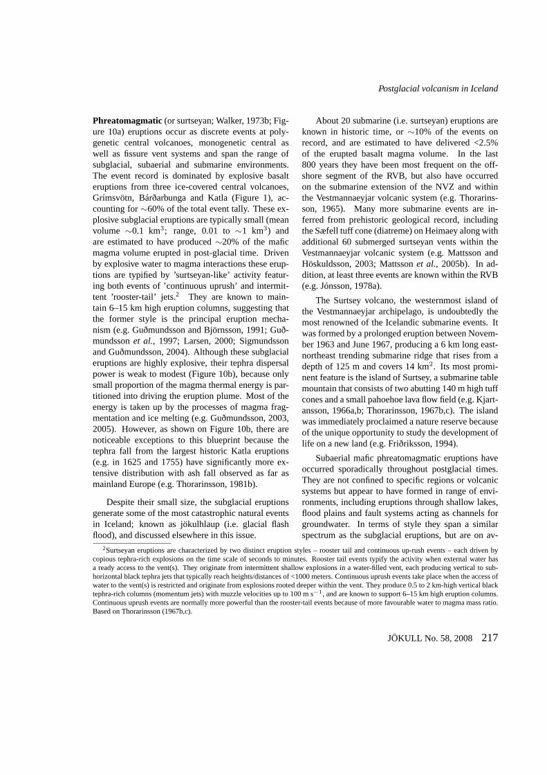
Rootless cone groups are the most common subaerialphreatomagmatic landforms in Iceland (e.g. Thorar-
rootless eruption
rootless cone
bedrock
lake
inflatingpahoehoe lava
surface crest ofsubsurface lava pathway
b)
lava pathway
rootlesscone group
c)
100
Basement
rootless cone tephra
lacustrine mudtilliteROOTLESS CONE GROUP
Distance
Ele
vati
on
lava
C1 explosion crater 1 etc.C1C2
C3C4
0
100
meters a.s.l.
90
80
70
60
200 300 400 500 600 meters
a)
Figure 11. (a) Schematic cross section through a rootless cone group. The cones typically rise 2–35 m abovehost lava surface and their basal diameters range from 5–450m (see key for details). (b) Formation of the root-less cone groups. The lava has covered a water-logged basin and thickened by flow inflation. Initially the lavaenters the wetlands as relatively small pahoehoe lobes froma set of frontal breakouts at the active lava fronts.The insulating crust seals the lobe interiors from the water-logged environment and the lobes inflate and expandlaterally in response to continued injection of lava. The internal pathways (or lava tubes) are thus extendedto new breakout points and the process repeats itself, extending the lava further across the wetlands. Anotherconsequence of this process is that the lava behind the active flow fronts increases in thickness by inflationand preferably so over the internal pathways. Consequently, the pathways begin to sink into the soft mud onthe lake bottom and cracks open in the base of the lava allowing the glowing hot lava to flow straight into thewater-saturated mud and initiate steam explosions. (c) A fully developed rootless cone group. After Fagentsand Thordarson (2007). –Stílsett (a) þversnið í gegnum gervigígaþyrpingu, (b) teikning sem sýnir myndungervigígaþyrpinga og (c) fullmynduð þyrping.
218 JÖKULL No. 58, 2008
Postglacial volcanism in Iceland
insson, 1951, 1953). They are positive landforms con-sisting of 10s–1000s closely packed crater cones thatcover an area ranging from 0.5 km2 to >100 km2.They are without exception associated with tube-fedpahoehoe and rubbly pahoehoe flow fields and thecones rest directly on the host lava flow (Figure 11a).The cone groups are situated where the lava advancedover wetlands, such as shallow lakes, fluvial plainsor swamps. Each cone is formed by a phreatomag-matic eruption driven by explosive interaction (i.e.physical mixing) between degassed liquid lava andwater-logged substrate (e.g. Thordarsonet al., 1992;Thordarson, 2000b; Fagents and Thordarson, 2007).These are sustained (hours to days) eruptions, as isevident from the distinctive internal layering of eachcone. The cones typically feature two distinct struc-tural components; a lower well-bedded sheet-like se-quence consisting of 0.2–0.6 m thick lapilli tephrabeds alternating with <0.2 m thick mud-rich andcross-bedded ash beds and a upper indistinctly bed-ded cone-forming sequence consisting of several 0.5–1.5 m thick spatter beds, often capped by a 1–2 m-thick welded to rheomorphic layer. The upward in-crease in grain size of these deposits emulates the at-tenuation of explosive power during individual root-less eruption. The cone conduits are crudely funnel-shaped, extending from the flow base up through co-herent lava and terminating in a bowl-shape crater rep-resent volcanic vents (Figure 11a). These conduitshave lateral feeders (i.e. lava tubes), hence the name’rootless’ eruptions, cones and cone groups.
Formation of rootless cone groups requires thelava to cross wetlands and a simultaneous initiation ofrootless eruptions through contact between hot lavaand external water, constructing cones on top of ac-tively advancing lava that are in no way modified byits movements. As shown on Figure 11b, this can onlybe accomplished if the lava is flowing within preferredinternal pathways (e.g. lava tubes) beneath a station-ary crust. If the explosions are powerful enough, theyburst through the overlying lava to emerge as rootlesseruptions that build cones around the vents (Figure11b). At any site, the eruption stops when the sup-ply of water (i.e. mud) and/or lava runs out. As theflow migrates across the wetlands, the explosive vents
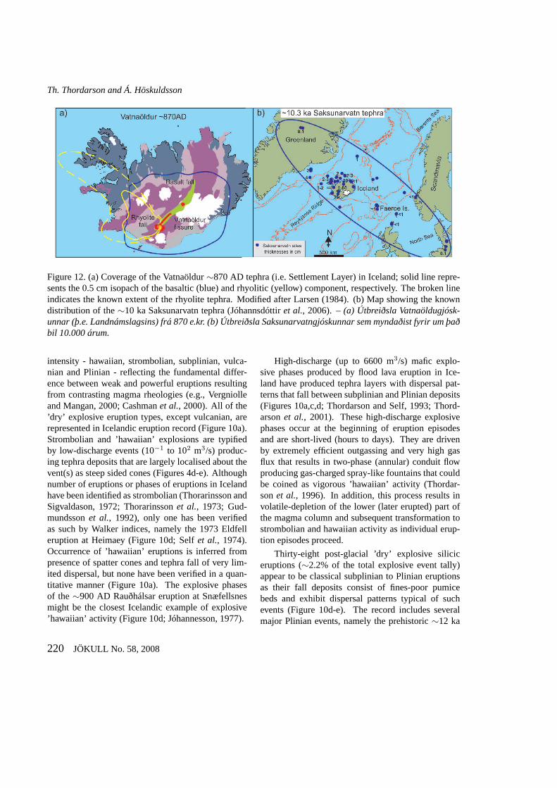
follow and, in doing so, gradually build a group ofrootless cones on top of the lava (Figure 11c).Phreatoplinian eruptions represent only 1.6% (24events) of post-glacial explosive eruptions in Iceland,yet are a diverse group that includes silicic eruptionsfrom ice-free and ice-capped central volcanoes as wellas large volume mafic fissure eruptions (Sparkset al.,1981; Larsenet al., 2001; Larsen, 1984; 2005). Theunifying feature of the phreatoplinian eruptions is thatthey all involve interaction of highly vesicular magmawith surface water, have Walker F indices of≥80%and form widespread thin tephra blankets dispersedover areas of 104 to 106 km2 (Figure 10a,d). How-ever, their tephra volumes vary by >2 orders of mag-nitude, from 0.01 to 5 km3. The Icelandic record alsoincludes the only verified historical example of sili-cic phreatoplinian eruptions (1875 AD Askja C) onEarth and is one of the type-eruption for this style ofvolcanism (e.g. Self and Sparks, 1978; Carey, 2008).Another historic example is the 1206 AD dacite erup-tion at Hekla, which formed the olive grey layer; animportant tephra marker horizon in South Central Ice-land (e.g. Larsen, 1979; Thordarsonet al., 1998). The1821 AD and 1613 AD dacite eruption of Eyjafjalla-jökull most likely fall also under this eruption cate-gory, along with 17 prehistoric events, including thetwelve Katla events that produced the SILK tephralayers (e.g. Larsenet al., 1999; 2001).
The explosive fissure eruptions of Vatnaöldur(∼870 AD) and Veiðivötn (1477 AD) can now beadded to the list as type examples of mafic phreato-plinian eruption (e.g. Larsen, 1984, 2005). Both ofthese eruptions produced widespread tephra layers(1–1.5 km3 DRE) that cover more than half of thecountry (Figures 10a,d and 12a). In terms of inten-sity and size they are only superseded by the threeearly Holocene (∼10–10.5 ka) mafic phreatoplinianeruptions at Grímsvötn that collectively produced theSaksunarvatn tephra layer (Jóhannsdóttiret al., 2006),which extends to the continents on both sides of theNorth Atlantic (Figure 12b).
DRY EXPLOSIVE ERUPTIONSAccording to the classification of Walker (1973b) thestyles of ’dry’ eruptions are in order of increasing
JÖKULL No. 58, 2008 219
Th. Thordarson and Á. Höskuldsson
Figure 12. (a) Coverage of the Vatnaöldur∼870 AD tephra (i.e. Settlement Layer) in Iceland; solid linerepre-sents the 0.5 cm isopach of the basaltic (blue) and rhyolitic(yellow) component, respectively. The broken lineindicates the known extent of the rhyolite tephra. Modified after Larsen (1984). (b) Map showing the knowndistribution of the∼10 ka Saksunarvatn tephra (Jóhannsdóttiret al., 2006). –(a) Útbreiðsla Vatnaöldugjósk-unnar (þ.e. Landnámslagsins) frá 870 e.kr. (b) Útbreiðsla Saksunarvatngjóskunnar sem myndaðist fyrir um þaðbil 10.000 árum.
intensity - hawaiian, strombolian, subplinian, vulca-nian and Plinian - reflecting the fundamental differ-ence between weak and powerful eruptions resultingfrom contrasting magma rheologies (e.g., Vergniolleand Mangan, 2000; Cashmanet al., 2000). All of the’dry’ explosive eruption types, except vulcanian, arerepresented in Icelandic eruption record (Figure 10a).Strombolian and ’hawaiian’ explosions are typifiedby low-discharge events (10−1 to 102 m3/s) produc-ing tephra deposits that are largely localised about thevent(s) as steep sided cones (Figures 4d-e). Althoughnumber of eruptions or phases of eruptions in Icelandhave been identified as strombolian (Thorarinsson andSigvaldason, 1972; Thorarinssonet al., 1973; Gud-mundssonet al., 1992), only one has been verifiedas such by Walker indices, namely the 1973 Eldfelleruption at Heimaey (Figure 10d; Selfet al., 1974).Occurrence of ’hawaiian’ eruptions is inferred frompresence of spatter cones and tephra fall of very lim-ited dispersal, but none have been verified in a quan-titative manner (Figure 10a). The explosive phasesof the∼900 AD Rauðhálsar eruption at Snæfellsnesmight be the closest Icelandic example of explosive’hawaiian’ activity (Figure 10d; Jóhannesson, 1977).
High-discharge (up to 6600 m3/s) mafic explo-sive phases produced by flood lava eruption in Ice-land have produced tephra layers with dispersal pat-terns that fall between subplinian and Plinian deposits(Figures 10a,c,d; Thordarson and Self, 1993; Thord-arsonet al., 2001). These high-discharge explosivephases occur at the beginning of eruption episodesand are short-lived (hours to days). They are drivenby extremely efficient outgassing and very high gasflux that results in two-phase (annular) conduit flowproducing gas-charged spray-like fountains that couldbe coined as vigorous ’hawaiian’ activity (Thordar-sonet al., 1996). In addition, this process results involatile-depletion of the lower (later erupted) part ofthe magma column and subsequent transformation tostrombolian and hawaiian activity as individual erup-tion episodes proceed.
Thirty-eight post-glacial ’dry’ explosive siliciceruptions (∼2.2% of the total explosive event tally)appear to be classical subplinian to Plinian eruptionsas their fall deposits consist of fines-poor pumicebeds and exhibit dispersal patterns typical of suchevents (Figure 10d-e). The record includes severalmajor Plinian events, namely the prehistoric∼12 ka
220 JÖKULL No. 58, 2008
Postglacial volcanism in Iceland
Vedde event (>3.3 km3) at the Katla volcano,∼7 kaH5 (0.7 km3),∼4.2 ka H4 (1.8 km3), ∼3.8 ka HS(0.45 km3) and∼3.1 ka H3 (2.2 km3) eruptions atHekla (e.g. Larsen and Thorarinsson, 1977; Lacasseetal., 1995). In historic time the main eruptions are thatof ∼870 AD Torfajökull (0.1 km3), 1104 AD Hekla(0.5 km3), 1158 AD Hekla (0.1 km3), 1362 AD Ör-æfajökull (2 km3) and 1875 AD Askja (0.3 km3) andspan the range of subplinian to Plinian (Figures 10d-e; Thorarinsson, 1958, 1967a, 1970b; Larsen, 1992;Larsenet al., 1999; Sparkset al., 1981; Carey, 2008).At least two of these eruptions, the 1875 AD Askjaand 1362 AD Öræfajökull, reveal a fairly complexeruption history. The 28–29 March 1875 Askja eventinvolved four distinct eruption phases, identified asunits B, C1, C2, and D within the deposits, repre-senting rapid shifts from ’dry’ to ’wet’ to ’dry’ erup-tions and changes in vent positions (e.g. Carey, 2008).The eruption began with a subplinian phase (B). Afterabout 9 hour-long pause the eruption picked up its in-tensity with∼1 hour-long phreatoplinian event (C1)followed by an∼2 hour-long drying-out phase char-acterized by pyroclastic density currents (C2). Theeruption culminated in a 5–6 hour-long Plinian phase(D). The main eruption at Öræfajökull volcano tookplace in early June 1362 (Thorarinsson, 1958). It be-gan with a weak phreatoplinian phase immediatelyfollowed by an intense collapsing-column phase pro-ducing pyroclastic density currents that reached >10km from the source vent. The event was punctuatedby a powerful Plinian phase (T. Thordarson and Á.Höskuldsson, unpubl. data, 2008).
CONCLUDING REMARKSPostglacial volcanism in Iceland is confined to dis-crete segments commonly referred to as the neovol-canic zones, which by definition occupy about onethird of Iceland (Figure 2). The volcanic system isrecognized as the principal structure of the neovol-canic zones and currently 30 active systems are identi-fied in Iceland (Figure 1). However, although the ’vol-canic system’ is a useful concept and at first glanceappears to be a robust volcano-tectonic identity, it isimportant to keep in mind that we have yet to pinpointthe volcano-tectonic or petrochemical parameters that
uniquely define a ’volcanic system’. This is not a triv-ial matter because candid examination of geologicalmaps and existing petrochemical data sets shows thatthe separation of many systems (e.g. 1-2-3, 4-8-9 and18-21-22-23-24 on Figure 1) is not clear cut and theirboundaries are, more often than not, ambiguous. In-evitably, a more detailed interdisciplinary research isrequired to clarify this issue because the concept ofthe volcanic system currently underpins our under-standing of Icelandic volcanism and geology.
The data compiled for this study indicates thatIceland has featured about 2400 eruptions in the last11 ka and that these eruptions have expelled about566±100 km3 of magma. However, and respectfullyrecognizing the ample efforts of previous researchers,this assessment is hampered to a degree by imper-fect postglacial eruption record, which largely stemsfrom lack of comprehensive and precise basic factualinformation, such as eruption size, intensity and fre-quency. Notwithstanding the data base that we havecompiled for this study from existing publications isneither complete nor flawless. Although we are of theopinion that the results extracted from it on numberof postglacial eruptions and their magma output areof the correct magnitude, the exact numbers shouldnot be taken too literally as well as applied cautiouslyand with proper judgement. However, despite theselimitations, some useful inferences can be made onthe basis of the current postglacial eruption data set:
1. Postglacial magma output in Iceland is about5 km3/century or about 1.4 times that of the volcan-ism in Hawaii, implying that Iceland is most produc-tive of the currently active terrestrial hotspots. How-ever, when it comes to number of eruptions Iceland isno match to Hawaii, where the event frequency is 3–5times higher.
2. Frequency distribution and magma volume pro-portions of mafic, intermediate and silicic eruptions isapproximately 91:6:3 (Table 2), underlining the gov-ernance of mafic magmatism. However, it does notsupport the notion that activity in Iceland is typifiedby bi-modal (basalt-silicic) magmatism (e.g. Jónas-son, 2007).
3. EVZ is responsible for >80% of all Holocene
JÖKULL No. 58, 2008 221
Th. Thordarson and Á. Höskuldsson
eruptions and∼60% of the erupted magma volume,reinforcing the conclusion put forth by Thordarsonetal. (2003b), that the EVZ has been the most prolificproducer of eruptions and magma in Iceland over thelast 11 ka. Among the main volcanic zones the RVBhas the lowest productivity, whereas the WVZ has thefewest eruptions and highest mean volume per event(Table 2).
4. Lava volume produced by mafic effusive erup-tions is not evenly distributed across the Holocene.About 30% (∼111 km3) of the total volume was pro-duced in the mid- to late-Holocene (i.e. post-5 ka)and the distribution is fairly even per millennia, ex-cept for the period 2–3 ka, when lava production ap-pears to have dropped by factor of∼3. The remain-ing 70% (∼258 km3) were erupted in the early- tomid Holocene (i.e. pre-5 ka) and the volume distribu-tion appears to be fairly even with respect to time (i.e.around 35–40 km3 per millennia), except that aboutone third (70 km3) this volume appears to have beenerupted between 10–11 ka.
In spite of the dominance of mafic magmatism,the diversity of Icelandic volcanism is undisputableand highlighted by the fact that it features close toall known terrestrial volcano and eruption types (e.g.Thordarson and Larsen, 2007; Larsen and Eiríksson,). However, the current postglacial eruption data setonly allows first order grouping of events; into the ba-sic categories of effusive, mixed and explosive post-glacial eruptions. A more sophisticated classificationis currently only applicable to a small selection ofevents because the necessary data has yet to be ob-tained for majority of the events on the record. There-fore, it is impossible at this stage to make a conclu-sive assessment of the eruption styles that typify Ice-landic volcanism. However, the analysis presentedhere clearly indicates dominance of subglacial explo-sive mafic events, >75% of the total eruption tally,when it comes to number of eruptions. This is primar-ily an artefact of environmental factors because themost active central volcanoes in the country are situ-ated beneath or capped by a glacier. When it comesto magma output the story is very different. Therecord is dominated by large volume (>1 km3) effu-sive mafic eruptions. About 50 such eruptions have
occurred throughout postglacial time, or 2% of the to-tal eruption tally, at recurrence frequency of 300-500years, yet they produced about 55% of the postglacialmagma volume.
Acknowledgements.
We are grateful to Olivier Roche, Guðrún Larsen andOlgeir Sigmarsson for their comments and sugges-tions, which significantly improved the manuscript.
ÁGRIP
Ísland er eitt virkasta og afkastamesta eldgosasvæðiá yfirborði jarðar með gostíðni upp á≥20 aburði áöld, sem framleiða að meðaltali≥5 km3 af kviku áhverjum 100 árum. Þrátt fyrir að basísk eldvirknisé ráðandi á Íslandi (90% allra gosa), þá eru allareldgosa- og kvikugerðir jarðar þekktar hér á landi.Eldvirkni á Nútíma afmarkast við virku eldgosabelt-in og þá helst við eldstöðvakerfin 30 sem þar er aðfinna. Sú eldgosaskrá sem nú liggur fyrir bendir tilþess að um 2400 eldgos hafi átt sér stað á Íslandi ásíðustu 11000 árum og að þau hafi samanlagt framleittum 566±100 km3 af kviku. Hraungos, að meðtöldumflæðibasaltgosum (>1 km3), eru um 500 talsins en af-gangurinn eru sprengigos af ýmsum gerðum. Algeng-ust eru basísk gos í jökli eða 77% allra sprengigosa,sem sýnir glöggt áhrif umhverfis á hegðun íslenskraeldgosa. Hvað varðar kvikuframleiðni, þá er framlagflæðibasaltgosa mest. Um 50 slík gos hafa orðið á Nú-tíma, eða aðeins um 2% allra atburða, en framleiddusamt 55% af heildarrúmmáli gosefna. Austurgosbelt-ið hefur verið afkastamest með >80% allra eldgosaog ∼60% gosefna. Að auki, er rúmmál basaltkvikuekki jafndreift í tíma, því aðeins 30% (∼111 km3)af heildarrúmmáli basískra gosefna kom upp í gosumá síðustu 5000 árum og 70% (∼258 km3) á tímabil-inu 5–11000 ár. Kvikuframleiðnin innan hvors tíma-bils virðist hafa verið nokkuð jöfn, eða á bilinu 20–30km3/1000 ár á síðustu 5000 árum, 35–40 km3/1000 árá tímabilinu frá 5–10.000 ár. Tímabilið 10–11.000 árstendur upp úr hvað þetta varðar, því þá virðist fram-leiðnin hafa verið tvöfalt meiri eða∼70 km3/1000 ár.
222 JÖKULL No. 58, 2008
Postglacial volcanism in Iceland
REFERENCESBjörnsson, A. 1985. Dynamics of crustal rifting in NE Iceland. J.
Geophys. Res.90, 10,151–10,162.Björnsson, A., G. Johnsen, S. Sigurdsson, G. Thorbergsson and
E. Tryggvason, 1979. Rifting of the plate boundary in northIceland 1975–1978.J. Geophys. Res.84, 3029–3038.
Blake, S. 1984. Magma mixing and hybridization processes atthe alkalic, silicic, Torfajökull central volcano triggered bytholeiitic Veidivötn fissuring, south Iceland.J. Volcanol.Geotherm. Res.22, 1–31.
Boygle J. 1999. Variability of tephra in lake and catchment sedi-ments, Svínavatn, Iceland.Global and Planetary Change21,129–149.
Brandsdóttir, B. and P. Einarsson 1979. Seismic activity associ-ated with the September 1977 deflation of the Krafla cen-tral volcano in North-Eastern Iceland.J. Volcanol. Geotherm.Res.6, 197–212.
Calderone, G., K. Grönvold, and N. Óskarsson 1990. The weldedair-fall tuff layer at Krafla, northern Iceland: A compositeeruption triggered by injection of basaltic magma.J. Vol-canol. Geotherm. Res.44, 303–314.
Carey R. 2008.Conduit, eruption and plume dynamics through-out the 28–29 March 1875 eruption of Askja volcano, Ice-land. Ph.D. thesis, Department of Geology and Geophysics,University of Hawaii, USA, 299 pp.
Cas, R. A. F. and J. V. Wright 1987.Volcanic Successions: Mod-ern and Ancient. Allen and Unwin, London, 528 pp.
Cashman, K. V., B. Sturtevant, P. Papale, and O. Navon 2000.Magmatic fragmentation.In: Sigurdsson, H., B. F. Houghton,S. R. McNutt, H. Rymer and J. Stix eds.Encyclopedia of Vol-canoes, Academic Press, San Diego, 421–430.
Dvorak, J. J. and D. Dzurisin 1993. Variations in magma supplyrate at Kilauea volcano, Hawaii.J. Geophys. Res.98, 22255–22268.
Einarsson, P. 1991. Umbrotin við Kröflu 1975–1989 (The 1975–1989 volcano-tectonic episode at Krafla volcano, N-Iceland).In: Garðarsson, A. and Á. Einarsson eds.Náttúra Mývatns(Nature of Mývatn). Hið íslenska náttúrufræðafélag, Reykja-vík.
Einarsson, T. 1949. The rate of production of material duringtheeruption. The Eruption of Hekla 1947–48.Soc. Sci. Isl.IV, 2,Reykjavík, 1–18.
Einarsson, T. 1965. The ring-mountains Hverfjall, Lúdent andHrossaborg in Northern Iceland.Vísindafélag Íslendinga,Greinar IV, 1–28.
Einarsson, S. and H. Jóhannesson 1989. Aldur Arnarseturshraunsá Reykjanesskaga (Age of the Arnarseturshraun lava flow,Reykjanes peninsula, SW-Iceland, in Icelandic).Fjölrit Nátt-úrufræðistofnunar8, 15 pp.
Fagents, S. A. and T. Thordarson 2007. Rootless cones in Icelandand on Mars.In: M. Chapman and I. Skilling eds.The Ge-ology of Mars: Evidence from Earth-Based Analogues, Cam-bridge University Press, 151–177.
Francis, P. and C. Oppenheimer 2004.Volcanoes. Oxford Univer-sity Press, Oxford, 521 pp.
Friðriksson, S. 1994.Surtsey: Lífríki í mótun. (Surtsey island: for-mation of an ecosystem). Hið íslenska náttúrufræðifélag andSurtseyjarfélagið, Reykjavík, 112 pp.
Grönvold, K., G. Larsen, P. Einarsson, S. Thorarinsson and K. Sæ-mundsson 1983. The Hekla eruption 1980–1981.Bull. Vol-canol.46, 349–363.
Guðmundsson, A. 1995. Infrastructure and mechanics of volcanicsystems in Iceland.J. Volcanol. Geotherm. Res.64, 1–22.
Guðmundsson, A. 2000. Dynamics of volcanic systems in Ice-land: Example of tectonism and volcanism at juxtaposed hotspot and mid-ocean ridge systems.Ann. Rev. Earth Planet.Sci.28, 107–140.
Guðmundsson, A., N. Oskarsson, K. Grönvold, K. Sæmundsson,O. Sigurdsson, S. Stefánsson, S. R. Gíslason, P. Einarsson,B.Brandsdóttir, G. Larsen, H. Jóhannesson and T. Thordarson1992. The 1991 eruption of Hekla, Iceland.Bull. Volcanol.54, 238–246.
Guðmundsson, M. T. 2003. Melting of ice by magma-ice-waterinteractions during subglacial eruptions as an indicator ofheat transfer in subaqueous eruptions.In: White, J. D. L.,J. L. Smellie and D. Clague eds.Geophys. Monogr. 140, Ex-plosive Subaqueous Volcanism, AGU, 61–72.
Guðmundsson, M. T. 2005. Subglacial volcanic activity in Ice-land.In: Caseldine, C.et al.eds.Iceland – Modern processesand past environments, Develop. Quat. Sci.5, Elsevier, 127–151.
Guðmundsson, M. T. and H. Björnsson 1991. Eruptions inGrímsvötn, Vatnajökull, Iceland, 1934–1991.Jökull 41, 21–46.
Guðmundsson, M. T., F. Sigmundsson and H. Björnsson 1997.Ice-volcano interaction of the 1996 Gjálp subglacial eruption,Vatnajökull, Iceland.Nature389, 954–957.
Gudmundsson, M. T., F. Pálsson, H. Björnsson and T. Högnadóttir2002. The hyaloclastite ridge formed in the subglacial 1996eruption in Gjálp, Vatnajökull, Iceland: present day shapeandfuture preservation.In: J. L. Smellie and M. G. Chapman eds.Volcano-Ice Interaction on Earth and Mars. Geol. Soc. Spec.Publ.202. The Geol. Soc. London, 319–336.
Guilbaud, M.-N. 2006.The origin of basaltic lava flow textures.Ph.D. Thesis, Department of Earth Sciences, Open Univer-sity, Milton Keynes, United Kingdom, 211 pp.
Guilbaud, M.-N., S. Self, T. Thordarson and S. Blake 2005. Mor-phology, surface structures, and emplacement of lavas pro-duced by Laki, A.D. 1783–1784.In: M. Manga and G. Ven-tura eds. Kinematics and dynamics of lava flows.Geol. Soc.Am. Spec. Pap.396, 81–102. doi:10.1130/2005.2396(07).
Guilbaud, M.-N., S. Blake, T. Thordarson and S. Self 2007. Roleof syn-eruptive cooling and degassing on textures of lavasfrom the AD 1783–84 Laki eruption, south Iceland.J. Petrol.48, 7, 1265–1294.
Haflidason, H., J. Eiríksson and S. van Kreveld 2000. Thetephrochronology of Iceland and the North Atlantic regionduring the Middle and Late Quaternary: a review.J. Quat.Sci.15, 3–22.
JÖKULL No. 58, 2008 223
Th. Thordarson and Á. Höskuldsson
Haraldsson, K. 2001.Heklugosið 2000. Dreifing gjósku frá fyrstagosdegi á landi, (Hekla eruption 2000. Distribution of tephraduring the first day, in Icelandic). B.Sc. Thesis, University ofIceland.
Hardardóttir, J., Á. Geirsdóttir and T. Thordarson 2001. Tephralayers in a sediment core from Lake Hestvatn, southernIceland: implications for evaluating sedimentation processesand environmental impacts on a lacustrine system caused bytephra fall deposits in the surrounding watershed.In: J. D. L.White and N. R. Riggs eds.Volcaniclastic Sedimentation inLacustrine Settings.Int. Ass. Sedimentologists (IAS) Spec.Publ. Blackwell Science, Oxford, 225–246.
Harris, A. J. L. and S. K. Rowland 2001. FLOWGO: a kinematicthermo-rheological model for lava flowing in a channel.Bull.Volcanol.63, 20–44.
Hjartarson, Á. 1988. Þjórsárhraunið mikla – stærsta nútímahraunjardar (The Great Thjórsá lava – the largest Holocene lava onEarth, in Icelandic).Náttúrufræðingurinn58(1), 1–16.
Hjartarson, Á. 2003.Efnismikil hraun og eldvirkni í 14.000 ár,(Large lava flows and volcanic activity over 14,000 years, inIcelandic), Jarðfræðafélag Íslands, Vorráðstefna 2003, Yfirlitog ágrip. Reykjavík, Geoscience Soc. Iceland, 10–11.
Höskuldsson, Á. and P. Imsland 1998. Geology of Snæfell, an in-traplate volcano in Eastern Iceland.Glettingur8, 22–30, (inIcelandic).
Höskuldsson A., R. S. J. Sparks and M. R. Carroll 2006. Con-straints on the dynamics of subglacial basalt eruptions fromgeological and geochemical observations at Kverkfjöll, NE-Iceland.Bull. Volcanol.68, 7–8.
Höskuldsson, A., K. Vogfjord, N. Oskarsson, R. Petersen andK.Grönvold 2007.The millennium eruption of Hekla in Febru-ary 2000.Bull. Volcanol.70, 169–182.
Houghton, B. F., C. J. N. Wilson, M. McWilliams, M. A. Lan-phere, S. D. Weaver, R. M. Briggs and M. S. Pringle 1995.Chronology and dynamics of a large silicic magmatic system:central Taupo Volcanic Zone, N. Z.Geology23, 13–16.
Houghton, B. F., C. J. N. Wilson, R. T. Smith and J. S. Gilbert2000. Phreatoplinian Eruptions.In: Sigurdsson, H., B. F.Houghton, S. R. McNutt, H. Rymer and J. Stix eds. Ency-clopedia of Volcanoes Academic Press, San Diego, 513–525.
Jakobsson, S. P. 1968. The geology and petrology of the Vest-mann Islands. A preliminary report.Surtsey Res. Progr. Rep.4, 113–129.
Jakobsson S. P. 1979. Petrology of recent basalts of the EasternVolcanic Zone, Iceland.Acta Natur. Isl.26, 1–103.
Jakobsson S. P., J. Jónsson and F. Shido 1978. Petrology of thewestern Reykjanes Peninsula, Iceland.J. Petrol.19, 669–705.
Jennings, A. E., K. Grönvold, R. Hilberman, M. Smith, and M.Hald 2002. High-resolution study of Icelandic tephras in theKangerlussuaq Trough, southeast Greenland, during the lastdeglaciation.J. Quat. Sci.17, 747–757.
Johnstrup, F. 1877a. Indberetning om den af Professor Johnstrupforetagne Undersögelsesreise paa Island i Sommeren 1876(hermed 2 kort og 2 tegninger).Særskilt Aftryk af Rigsdagsti-denden for den 29de ordentlige Samling1876–77, Tillæg B.Sp. 899–926, Köbenhavn, J. H. Schultz, 1877, 14pp.
Johnstrup, F. 1877b. Om de i Aaret 1875 forefaldne vulkanskeudbrud paa Island.Geogr. TidsskriftI, 50–66.
Johnstrup, F. 1886. Om de vulkanske Udbrud og Solfatarerne iden nordöstlige del af Island (med 3 Kaart).Den Naturhistor.Foren. Festskr.Köbenhavn, 1886, 1–52 pp.
Jóhannesson, H. 1977. Þar var ei bærinn sem nú er borgin (Theage of two recent lava flows in Hnappadalur, W-Iceland).Náttúrufræðingurinn47, 129–141.
Jóhannesson, H. 1982. Kvarter eldvirkni á Vesturlandi (Quater-nary volcanism in Western Iceland).In: H. Thorarinsdottir,O. H. Oskarsson, S. Steinthorsson and T. Einarsson eds.El-dur er í Norðri (Fires are up in the North, in Icelandic).Sögufélagið, Reykjavík, 129–137.
Jóhannesson, H. 1983. Gossaga Grímsvatna 1900–1983 í stuttumáli (A brief review of the volcanic activity of the Grímsvötnvolcanic system 1900–1983).Jökull33, 146–147.
Jóhannesson, H. and S. Einarsson 1988. Krísuvíkureldar I: Al-dur Ögmundarhrauns og miðaldalagsins (The Krýsuvík FiresI: Age of the Ögmundarhraun lava and the Medieval tephralayer, in Icelandic).Jökull38, 71–87.
Jóhannesson, H. and K. Sæmundsson, 1998.Geological map ofIceland, 1:500.000. Bedrock geology.Icelandic Institute ofNatural History and Iceland Geodetic Survey, Reykjavík.
Jóhannesson, H., R. M. Flores and J. Jónsson 1981. A short ac-count of the Holocene tephrochronology of the Snæfells-jökull central volcano, western Iceland.Jökull31, 23–30.
Jóhannsdóttir, G. E., T. Thordarson, Á. Geirsdóttir and G. H.Miller 2006. The widespread∼10ka Saksunarvatn tephra: AProduct of three large basaltic phreatoplinian eruptions.AGUEos Trans.Fall Meeting Suppl., 2006, V33B–0666.
Jóhannsdóttir, G. E. 2007.Mid Holocene to late glacialtephrochronology in West Iceland as revealed in three la-custrine environments.M.Sc. Thesis, University of Iceland,Reykjavík February 2007, 170 pp.
Jónasson, K. 2007. Silicic volcanism in Iceland: Composition anddistribution within the active volcanic zones.J. Geodyn.43,1, 101–117.
Jónsson, J. 1978a.Jarðfræðikort af Reykjanesskaga. I.Skýringarvið jardfræðikort. (Geological map of the Reykjanes Penin-sula). National Energy Authority Research Report OS-JHD7831, Orkustofnun, Reykjavík.
Jónsson, J. 1978b. Eldstöðvar og hraun í Skaftafellsþingi (Vol-canic vents and lava flows in V-Skaftafellssýsla county).Náttúrufræðingurinn48, 196–232.
Jónsson, J. 1983. Eldgos á sögulegum tíma á Reykjanesskaga(Volcanic eruptions in historical time on the Reykjanes penin-sula, SW Iceland, in Icelandic).Náttúrufræðingurinn52,127–139.
Jónsson, Ó. 1945.Ódáðahraun(Ódáðahraun region, in Icelandic),Bókaútgáfan Norðri HF, Akureyri, 447 pp.
Karhunen, R. 1988.Eruption mechanism and rheomorphism dur-ing the basaltic fissure eruption in Biskupsfell, Kverkfjöll,north-central Iceland.Nordic Volcanol. Inst. Res. Rep. 8802,Reykjavík, 91pp.
Keszthelyi, L. and S. Self 1998. Some physical requirements forthe emplacement of long basaltic lava flows.J. Geophys. Res.103, 27447–27464.
224 JÖKULL No. 58, 2008
Postglacial volcanism in Iceland
Keszthelyi, L., A. S. McEwen and T. Thordarson 2000. Terres-trial analogs and thermal models for Martian flood lavas.J.Geophys. Res.105, 15027–15050.
Keszthelyi L., T. Thordarson, A. S. McEwen, H. Haack, M.-N.Guilbaud, S. Self and M. J. Rossi 2004, Icelandic analogs toMartian flood lavas.Geochem. Geophys. Geosyst.5, Q11014,doi:10.1029/2004GC000758.
Kjartansson, G. 1966a. A contribution to the morphology of Surt-sey.Surtsey Res. Progr. Rep.2, 125–128.
Kjartansson, G. 1966b. Stapakenningin og Surtsey.Náttúrufræð-ingurinn36, 1–34.
Kristjánsdóttir G. B., J. S. Stoner, A. Jennings, J. AndrewsandK. Grönvold 2007. Geochemistry of Holocene cryptotephrasfrom the North Iceland shelf (MD99-2269): Intercalibrationwith radiocarbon and paleomagnetic chronostratigraphies.The Holocene17, 2, 155–176.
Lacasse, C. and C. D. Garbe-Schönberg 2001. Explosive silicicvolcanism in Iceland and the Jan Mayen area during the last6 Ma: sources and timing of major eruptions.J. Volcanol.Geotherm. Res.107, 113–147.
Lacasse, C., H. Sigurdsson, H. Jóhannesson, M. Paterne and S.Carey 1995. Source of Ash Zone 1 in the North Atlantic.Bull.Volcanol.57, 18–32.
Larsen, G. 1979. Um aldur Eldgjárhrauna (Tephrochronologicaldating of the Eldgjá lavas in S-Iceland, in Icelandic).Nátt-úrufræðingurinn49, 1–25.
Larsen, G. 1982. Gjóskutímatal Jökuldals og nágrennis(Tephrochronology of the Jökuldalur area and its vicinity).In: Thorarinsdottir, H., O. H. Oskarsson, S. Steinthorssonand T. Einarsson eds.Eldur er í Norðri (Fires are up in theNorth). Sögufélagið, Reykjavík, 51–65.
Larsen G. 1984. Recent volcanic history of the Veidivötn fissureswarm, southern Iceland – an approach to volcanic risk as-sessment.J. Volcanol. Geotherm. Res.22, 33–58.
Larsen G. 1992.Gjóskulagið úr Heklugosinu 1158(The tephralayer from the 1158 AD eruption of Hekla). JarðfræðafélagÍslands, Vorráðstefna, Yfirlit og ágrip. Geoscience Soc. Ice-land, Reykjavík 25–27.
Larsen, G. 2000. Holocene eruptions within the Katla volcanicsystem, south Iceland: Characteristics and environmental im-pact.Jökull49, 1–28.
Larsen, G. 2002. A brief overview of eruptions from ice-coveredand ice-capped volcanic systems in Iceland during the past11 centuries: frequency, periodicity and implications.In:Smellie, J. L. and M. G. Chapman eds,Volcano-Ice Inter-action on Earth and Mars. Geol. Soc. Lond. Spec. Publ. 202,London, 81–90.
Larsen, G. 2005. Explosive volcanism in Iceland: Three exam-ples of hydromagmatic basaltic eruptions on long volcanicfissures within the past 1200 years.EGU Geophys. Res. Ab-stractsVol. 7, 10158.
Larsen, G. and S. Thorarinsson 1977. H-4 and other acid Heklatephra layers.Jökull27, 28–46.
Larsen, G. and J. Eiríksson 2007. Late Quaternary terrestrialtephrochronology of Iceland – frequency of explosive erup-tions, type and volume of tephra deposits.J. Quat Sci.23, 2,109–120.
Larsen, G., E. G. Vilmundardóttir and B. Thorkelsson 1992. Hek-lugosid 1991: Gjóskufallid og gjóskulagid frá fyrsta degigossins (The Hekla eruption of 1991 – The tephra fall).Nátt-úrufræðingurinn61, 159–176.
Larsen, G., M. T. Gudmundsson and H. Björnsson 1998. Eightcenturies of periodic volcanism at the center of the Icelandichotspot revealed by glacier tephrostratigraphy.Geology26,943–946.
Larsen G., A. J. Dugmore and A. J. Newton 1999. Geochemistryof historical-age silicic tephras in Iceland.The Holocene9,463–471.
Larsen, G., A. J. Newton, A. J. Dugmore and E. Vilmundardóttir2001. Geochemistry, dispersal, volumes and chronology ofHolocene silicic tephra layers from the Katla volcanic sys-tem, Iceland.J. Quat. Sci.16, 119–132.
Larsen, G., J. Eiríksson, K. L. Knudsen and J. Heinemeier2002. Correlation of late Holocene terrestrial and marinetephra markers, north Iceland: implications for reservoir agechanges.Polar Res.21, 2: 283–290.
Mattsson, H. and Á. Höskuldsson 2003. Geology of the Heimaeyvolcanic centre, south Iceland: early evolution of a centralvolcano in a propagating rift?J. Volcanol. Geotherm. Res.127, 55–71.
Mattsson H. and Á. Höskuldsson 2005a. Stratigraphy, formationof flow-lobe tumuli and eruption duration in the 5900 BP Hel-gafell eruption, Vestmannaeyjar volcanic system, south Ice-land.J. Volcanol. Geotherm. Res.147, 157–172.
Mattsson, H., Á. Höskuldsson and S. Hand 2005b. Crustal xeno-liths in the 6200 BP Sæfell tuff-cone, south Iceland: evi-dence for a deep, diatreme-forming, Surtseyjan eruption.J.Volcanol. Geotherm. Res.145, 234–248.
Macdonald, R., D. W. McGarvie, H. Pinkerton, R. L. Smith and Z.A. Palacz 1990. Petrogenetic evolution of the Torfajokull vol-canic complex, Iceland 1. Relationship between the magmatypes.J. Petrol.31(2), 429–459.
McGarvie, D. W., R. Macdonald, H. Pinkerton and R. L. Smith1990. Petrogenic evolution of the Torfajökull volcanic com-plex, Iceland II. The role of magma mixing.J. Petrol. 31,461–481.
Miller D. J., T. Thordarson and M. M. Morrissey 1990. The Hross-aborg tuff cone, North-Iceland: Eruptive sequence and depo-sitional processes.IAVCEI, General Assembly, Mainz, Ger-many, abstracts.
Morrissey, M. M., B. Zimanowski, K. Wohletz and R. Buettner2000. Phreatomagmatic fragmentation.In: Sigurdsson, H.,B. F. Houghton, S. R. McNutt, H. Rymer and J. Stix eds.En-cyclopedia of Volcanoes, Academic Press, San Diego, 431–446.
Moune S., O. Sigmarsson, T. Thordarson and P.-J. Gau-thier 2006. Recent volatile evolution in the magmatic sys-tem of Hekla volcano, Iceland,Earth Planet. Sci. Lett.doi:10.1016/j.epsl.2006.12.024.
Nichols, A. R. L., M. R. Carroll and Á. Höskuldsson 2002. Is theIcelandic hot spot also wet? Evidence from the water con-tents of undegassed submarine and subglacial pillow basalts.Earth Planet. Sci. Lett.202, 77–87.
JÖKULL No. 58, 2008 225
Th. Thordarson and Á. Höskuldsson
Oddsson, B. 2007.The Grímsvötn eruption in 2004: Dispersal andTotal Mass of Tephra and Comparison with Plume TransportModels.M.Sc. Thesis, Department of Physics, University ofIceland, 112 pp.
Óladóttir, B.A., G. Larsen, T. Thordarson and O. Sigmarsson2005. The Katla volcano S-Iceland: Holocene tephra stratig-raphy and eruption frequency.Jökull55, 53–74.
Óladóttir, B. A., T. Thordarson, G. Larsen, and O. Sigmarsson2007. Did the Mýrdalsjökull ice-cap survive the Holocenethermal maximum? Evidence from sulfur contents in Katlatephra layers (Iceland) from the last∼8400 years.Ann.Glaciol. 45, 183–188.
Óladóttir, B. A., O. Sigmarsson, G. Larsen and T. Thordarson2008. The Katla volcano, Iceland: magma composition, dy-namics and eruption frequency as recorded by Holocenetephra layers.Bull. Volcanol.70, 475–493.
Oman, L., A. Robock, G. L. Stenchikov, T. Thordarson,D. Koch, D. T. Shindell and C. Gao 2006. Modelingthe distribution of the volcanic aerosol cloud from the1783–1784 Laki eruption.J. Geophys. Res.Atmosp. 111,doi:10.1029/2005JD006899.
Pyle, D. M. 1989. The thickness, volume and grain-size of tephrafall deposits.Bull. Volcanol.51, 1–15.
Róbertsdóttir, B. G., Larsen, G. and J. Eiríksson 2002. A newdetailed stratigraphical and geochemical record of 30 tephralayers from the Hekla volcanic system, Iceland, 2980–850cal. BP.The 25th Nordic Geological Winter Meeting, Reykja-vík, Abstracts volume, 178.
Rossi, M. 1996. Morphology and mechanism of eruption of post-glacial shield volcanoes in Iceland.Bull. Volcanol.57, 530–540.
Saunders, A. D., J. G. Fitton, A. C. Kerr, M. J. Norry and R.W. Kent 1997. The North Atlantic Igneous Province.In: Ma-honey, J. J. and M. F. Coffin eds.Large Igneous Provinces:Continental, Oceanic, and Planetary Flood Volcanism, Geo-phys. Monogr. 100, Am. Geophys. Union, Washington DC,45–93.
Self, S. and R. S. J. Sparks 1978. Characteristics of widespreadpyroclastic deposits formed by the interaction of silicicmagma and water.Bull. Volcanol.41, 196–212.
Self, S., R. S. J. Sparks, B. Booth and G. P. L. Walker 1974.The 1973 Heimaey strombolian scoria deposit, Iceland.Geol.Mag.111, 6, 539–548.
Self, S., T. Thordarson, L. Keszthelyi, G. P. L. Walker, K. Hon,M. T. Murphy, P. Long and S. Finnemore 1996. A new modelfor the emplacement of the Columbia River Basalt as large,inflated pahoehoe sheet lava flow fields.Geophys. Res. Lett.23, 2689–2692.
Self, S., T. Thordarson and L. Keszthelyi 1997. Emplacementof continental flood basalt lava flows.In: Mahoney, J. J.and M. F. Coffin eds.Large Igneous Provinces: Continental,Oceanic, and Planetary Flood Volcanism.Geophys. Monogr.100, Am. Geophys. Union, Washington DC, 381–410.
Self, S., L. Keszthelyi and T. Thordarson 1998. The importanceof pahoehoe.Ann. Rev. Earth Planet. Sci.26, 81–110.
Self, S., M. Widdowson, T. Thordarson and A. E. Jay 2006.Volatile fluxes during flood basalt eruptions and potential ef-fects on the global environment: A Deccan perspective.EarthPlanet. Sci. Lett.248, 517–531.
Sigbjarnarson, G. 1988.Krepputunga-Brúardalir, jarðfræðikortog skýringar(Krepputunga-Brúardalir, geological map andexplanations), OS-88038/VOD-06, Reykjavík 1988, 44 pp.
Sigbjarnarson, G. 1996. Norðan Vatnajökuls III. Eldstöðvar oghraun frá Nútíma (Region north of Vatnajökull glacier III.Eruptive vents and lava flows).Náttúrufræðingurinn65, 3–4,199–212.
Sigmundsson, F. and M. T. Gudmundsson 2004. The Grímsvötneruption, November 2004.Jökull54, 139–142.
Sigurdsson, H. and R. S. J. Sparks 1978. Rifting episode innorth Iceland in 1874–1875 and the eruptions of Askja andSveinagjá.Bull. Volcanol.41, 1–19.
Sigurðsson, J. 1875. Skýrsla um eldgosið í Þingeyjarsýslu eptirdannibrogs-og alþingismann Jón Sigurðsson á Gautlöndum(A report on the eruption in Thingeyjarshire).Norðanfari14.,no. 13, March 3. 26.
Sigurgeirsson, M. A. 1992.Gjóskumyndanir á Reykjanesi,(Tephra deposits on the Reykjanes volcanic system). M.Sc.Thesis, University of Iceland, 114 pp.
Sigurgeirsson, M. A. 1995. Yngra-Stampagosið á Reykjanesi(The Younger-Stampar eruption at Reykjanes, SW-Iceland).Náttúrufræðingurinn64, 211–230.
Sigvaldason, G. E., K. Annertz and M. Nilsson 1992. Effect ofglacier loading/deloading on volcanism: postglacial volcanicproduction rate of the Dyngjufjöll area, central Iceland.Bull.Volcanol.54, 385–392.
Sinton, J., K. Gronvold and K. Sæmundsson 2005. Post-glacial eruptive history of the Western Volcanic Zone,Iceland. Geochem. Geophys. Geosyst.6 (12), Q12009,doi:10.1029/2005GC001021.
Sparks, R. S. J., L. Wilson and H. Sigurdsson 1981. The pyro-clastic deposits of the 1875 eruption of Askja, Iceland.Phil.Trans. Roy. Soc. Lond.Series A 299, 241–273.
Steinthórsson, S. 1978. Tephra layers in a drill core from theVatnajökull Ice Cap.Jökull27, 2–27.
Swanson, D. A. 1972. Magma supply rate at Kilauea volcano,1952–1971.Science175, 169–170.
Sæmundsson, K. 1972. Jarðfræðiglefsur um Torfajökulssvæðið(Notes on the geology of the Torfajökull central volcano, inIcelandic).Náttúrufræðingurinn42, 82–99.
Sæmundsson, K. 1978. Fissure swarms and central volcanoes ofthe neovolcanic zones of Iceland.Geol. J. Spec. Iss.10, 415–432.
Sæmundsson, K. 1979. Outline of the geology of Iceland.Jökull29, 7–28.
Sæmundsson, K. 1991. Jarðfræði Kröflukerfisins (Geology of theKrafla volcanic system).In: Gardarsson, A. and Á. Einars-son eds.Náttúra Mývatns, Hið íslenska náttúrufræðifélag,Reykjavík, 25–95.
Sæmundsson, K. 1992. Geology of the Thingvallavatn area.In: Jónasson, P. M. ed.Ecology of Oligothropic, SubarcticThingvallavatn, Oikos64, 40–68.
226 JÖKULL No. 58, 2008
Postglacial volcanism in Iceland
Sæmundsson, K. 1995.Hengill Geological Map (Bedrock),1:50,000. Orkustofnun, Hitaveita Reykavíkur and Land-mælingar Íslands, Reykjavík.
Sæmundsson, K. and G. Ó. Fridleifsson 2001.Jarðfræði-og jarðhitakort af Torfajökulssvæðinu, (Geological andgeothermal map of the Torfajokull area). Orkustofnun, OS-2001/036.
Thorarinsson, S. 1951. Laxárgljúfur and Laxárhraun: Atephrochronological study.Geograf. Ann.33 (1–2), 1–89.
Thorarinsson, S. 1952a. Hverfjall I.Náttúrufræðingurinn22,113–129.
Thorarinsson, S. 1952b. Hverfjall II.Náttúrufræðingurinn22,145–172.
Thorarinsson, S. 1953. The crater groups in Iceland.Bull. Vol-canol.14, 3–44.
Thorarinsson, S. 1954. The tephra-fall from Hekla on March 29th1947.In: Einarsson, T., G. Kjartansson and S. Thorarinssoneds.The Eruption of Hekla 1947–48.Soc Sci. Isl., II (3), 1–68.
Thorarinsson, S. 1958. The Öræfajökull eruption of 1362.ActaNat. Isl. II, 2, 1–100.
Thorarinsson, S. 1965. Neðansjávargos við Ísland (Submarineeruptions off the coast of Iceland).Náttúrufræðingurinn35,49–74.
Thorarinsson, S. 1967a. The eruptions of Hekla in historicaltimes.In: Einarsson, T., G. Kjartansson and S. Thorarinssoneds.The Eruption of Hekla 1947–48. Soc Sci. Isl., I, 1–177.
Thorarinsson, S. 1967b. The Surtsey eruption and related scien-tific work. The Polar Record13 (86), 571–578.
Thorarinsson, S. 1967c.Surtsey - the new Island in the North At-lantic. Viking Press, New York, 105 pp.
Thorarinsson, S. 1970.Hekla. Almenna Bókafélagið, Reykjavík,59 pp. (in Icelandic)
Thorarinsson, S. 1974.Vötnin stríð. Saga Grímsvatnagosa ogSkeiðarárhlaupa(The swift flowing rivers. Grímsvötn erup-tions and jökulhlaups in river Skeidará). Bókaútgáfa Men-ningarsjóðs, Reykjavík, 258 pp.
Thorarinsson, S. 1975. Katla og annáll Kötlugosa (Katla anditshistorical eruptions).Árbók Ferðafélags Íslands1975, 125–149.
Thorarinsson, S. 1976. Course of events.In: Einarsson, T., G.Kjartansson and S. Thorarinsson eds.The Eruption of Hekla1947–48, Soc Sci. Isl., IV (1), 1–47.
Thorarinsson, S. 1981a. Jarðeldasvæði á nútíma (Volcanic areasof the Holocene).In: Náttúra Íslands, 2nd edition, Almennabókafélagið, Reykjavík, 81–119.
Thorarinsson, S. 1981b. Greetings from Iceland: Ash-fallsandvolcanic aerosols in Scandinavia.Geograf. Ann.63, 109–118.
Thorarinsson, S. and G. E. Sigvaldason 1962. The eruption inAskja 1961.Am. J. Sci.260, 641–651.
Thorarinsson, S. and G. E. Sigvaldason 1972. The Hekla eruptionof 1970.Bull. Volcanol.36, 269–288.
Thorarinsson, S. and K. Sæmundsson 1979. Volcanic activity inhistorical time.Jökull29, 29–32.
Thorarinsson, S., S. Steinthórsson, T. Einarsson, H. Kristmanns-dóttir and N. Óskarsson 1973. The eruption on Heimaey, Ice-land.Nature241, 372–375.
Thordarson, T. 2000a. Morphology and structure of the AD 1963–67 Surtsey lava flow field: results from preliminary observa-tions.Surtsey Res. Prog. Rep.XI, 125–142.
Thordarson, T. 2000b. Rootless eruptions and cone groups inIce-land: Products of authentic explosive water to magma in-teractions.In: V. C. Gulick and M. T. Gudmundsson eds.Volcano/ice interactions on Earth and Mars. Univ. Iceland,Reykjavík, 48.
Thordarson, T. 2008. Hraun (Lava).In: Sigmundsson, F.et al.eds.Nattúruvá á Íslandi - eldgosavá, (Natural Hazards in Iceland– volcanic hazards), in press.
Thordarson, T. and S. Self 1993. The Laki (Skaftár Fires) andGrímsvötn eruptions in 1783–1785.Bull. Volcanol.55, 233–263.
Thordarson, T. and S. Self 1996. Sulphur, chlorine and fluorinedegassing and atmospheric loading by the Roza eruption,Columbia River Basalt Group, Washington, USA.J. Volc.Geotherm. Res.74, 49–73.
Thordarson, T. and S. Self 1998. The Roza member, ColumbiaRiver Basalt group: A gigantic pahoehoe lava flow fieldformed by endogenous processes?J. Geophys. Res.103,27411–27445.
Thordarson, T. and S. Self 2003. Atmospheric and environmentaleffects of the 1783–1784 Laki eruption, Iceland: a review andreassessment.J. Geophys. Res.103, 27411–27445. 108(D1),10.1029/2001JD002042.
Thordarson, T. and G. Larsen 2007. Volcanism in Iceland in His-torical Time: Volcano types, eruption styles and eruptive his-tory. J. Geodyn., 43, 1, 118–152.
Thordarson, T. and O. Sigmarsson 2008. Effusive activity in the1963–67 Surtsey eruption, Iceland: flow emplacement andgrowth of small lava shields.In: Thordarson, T., G. Larsen,S. Self, S. Rowland and Á. Höskuldsson eds.Studies in Vol-canology: The Legacy of George Walker. Geol. Soc. LondonSpec. Publ., in press.
Thordarson T., M. M. Morrissey, G. Larsen and H. Cýrusson1992. Origin of rootless cone complexes in S-Iceland.In: Á.Geirsdóttir, H. Norddahl and G. Helgadóttir eds.The 20thNordic Geological Winter Meeting. Icelandic GeoscienceSoc., Reykjavík, abstracts: 169.
Thordarson, T., S. Self, N. Óskarsson and T. Hulsebosch 1996.Sulfur, chlorine, and fluorine degassing and atmosphericloading by the 1783–1784 AD Laki (Skaftár Fires) eruptionin Iceland.Bull. Volcanol.58, 205–225.
Thordarson, T., D. J. Miller and G. Larsen 1998. New data on theage and origin of the Leidólfsfell cone group in south Iceland.Jökull46, 3–15.
Thordarson, T., D. J. Miller, G. Larsen, S. Self and H. Sigurds-son 2001. New estimates of sulfur degassing and atmosphericmass-loading by the 934 AD Eldgjá eruption, Iceland.J. Vol-canol. Geotherm. Res.108 (1–4), 33–54.
Thordarson, T., G. Larsen, S. Steinthorsson and S. Self 2003a.The 1783–1785 A.D. Laki-Grímsvötn eruptions II: Appraisalbased on contemporary accounts.Jökull53, 11–48.
JÖKULL No. 58, 2008 227
Th. Thordarson and Á. Höskuldsson
Thordarson, T., S. Self, D. J. Miller, G. Larsen and E. G. Vil-mundardóttir 2003b. Sulphur release from flood lava erup-tions in the Veiðivötn, Grímsvötn and Katla volcanic systems,Iceland.In: Oppenheimer, C., D. M. Pyle and J. Barclay eds.Volcanic Degassing.Geol. Soc. Lond. Spec. Publ. 213, 103–121.
Thordarson, Th., G. E. Jóhannsdóttir and Á. Geirsdóttir 2005.Tephra layers in lake sediments from South and West Iceland.European Geosci. Uni. Gen. Assem., Geophys. Res. Abstr.,Vienna, 7962/gra/EGU05-A-10766 1607.
Tolan, T. L., S. P. Reidel, M. H. Beeson, J. L. Anderson, K. R.Fecht and D. A. Swanson 1989. Revision to the estimates ofthe aerial extent and volume of the Columbia River BasaltGroup.In: S. P. Reidel and P. R. Hooper eds.Volcanism andTectonism in the Columbia River flood-basalt province.Geol.Soc. Am. Spec. Paper 239, Boulder, Colorado, 1–20.
Torfason, H., Á. Hjartarson, H. Jóhannesson, J. Jónsson andK. Sæmundsson 1993.Geological map, bedrock geology,Elliðavatn, 1613, III-SV-B, 1:25000. The Iceland GeodeticSurvey, Nat. Energy Auth. and the towns of Hafnarfjörður,Garðabær, Kópavogur, Seltjarnarnes and the City of Reykja-vík.
Tryggvason, T. 1957. The gabbro bombs at Lake Grænavatn.Bull.Geol. Inst. Uppsala Univ.38, 1–5.
Vergniolle, S. and M. Mangan 2000. Magmatic fragmentation.In:Sigurdsson, H., B. F. Houghton, S. R. McNutt, H. Rymer andJ. Stix eds.Encyclopedia of Volcanoes. Academic Press, SanDiego, 447–494.
Vilmundardóttir, E. G. 1977.Tungnaárhraun(Tugnaá lavas),Geol. Rep. OS ROD 7702, Orkustofnun, Reykjavík, 156 pp.
Vilmundardóttir, E. G., Á. Gudmundsson and S. P. Snorrason1983.Geological map, Búrfell-Langalda, 3540 B, Nat. En-ergy Auth. and Nat. Power Company, Reykjavík.
Vilmundardóttir, E. G., S. P. Snorrason, G. Larsen and Á. Gud-mundsson 1988.Geological map, Sigalda-Veidivötn, 3340 B,Nat. Energy Auth. and Nat. Power Company, Reykjavík.
Vilmundardóttir E. G., Á. Gudmundsson, S. P. Snorrason and G.Larsen 1990.Geological map Botnafjöll, 1913 IV, 1:50.000,
Iceland Geodetic Survey, Nat. Energy Auth. and Nat. PowerCompany, Reykjavík.
Vilmundardóttir, E. G., G. Larsen and S. P. Snorrason 1999a.Geological map Nyrdri Háganga1914 II, 1:50.000. IcelandGeodetic Survey, Nat. Energy Auth. and Nat. Power Com-pany, Reykjavík.
Vilmundardóttir, E. G., S. P. Snorrason, G. Larsen og B. Aðal-steinsson 1999b.Geological map, Tungnaárjökull1913 I,1:50.000, Iceland Geodetic Survey, Nat. Energy Auth. andNat. Power Company, Reykjavík.
Walker, G. P. L. 1973a. Lengths of lava flows.Phil. Trans. Roy.Soc. Lond.A 274, 107–118.
Walker, G. P. L. 1973b. Explosive volcanic eruptions – a new clas-sification scheme.Geol. Rund.62, 431–446.
Walker, G. P. L. 1991. Structure, and origin by inflation of lava un-der surface crust, of tumuli, ’lava rises’ , ’lava-rise pits’, and’lava-inflation clefts’ in Hawaii.Bull. Volcanol.53, 546–558.
Watts, W. L. 1875. Lýsing frá Watts á eldgosinu á Mývatnsöræ-fum 15. ágúst. Prentuð í enskum blöðum og oss tilsend afhinum heiðraða höfundi (Description of the eruption in Mý-vatnsöræfi by W. L. Watts).Þjóðólfur 27, no. 28, 112–113,Sept. 30.
White, J. D. L. and B. F. Houghton 2000. Surtseyan and re-lated phreatomagmatic eruptions.In: Sigurdsson, H., B. F.Houghton, S. R. McNutt, H. Rymer and J. Stix eds.Encyclo-pedia of Volcanoes, Academic Press, San Diego, 495–512.
Wohletz, K. H. 1983. Mechanisms of hydrovolcanic pyroclast for-mation: grain-size, scanning electron microscopy, and exper-imental studies.J. Volc. Geotherm. Res.17, 31–63.
Wohletz, K. H. 1986. Explosive magma-water interactions: Ther-modynamics, explosion mechanisms, and field studies.Bull.Volcanol.48, 245–264.
Wolfe C. J., I. T. Bjarnason, J. C. Van Decar and S. C. Solomon1997. Seismic structure of the Iceland mantle plume.Nature385, 245–247.
228 JÖKULL No. 58, 2008