post opening project evaluation one year after...
TRANSCRIPT

POPE _ A66 Long Newton OYA _ final.docx
Post Opening Project EvaluationA66 Long Newton Grade Separated Junction One Year After Study
Post Opening Project Evaluation One Year After Study
A66 Long Newton Grade Separated Junction
October 2010
NoticeThis report was produced by Atkins Consultants for the Highways Agency for the specific purpose of POPEOne Year After evaluation of A66 Long Newton GSJ Scheme.
This report may not be used by any person other than the Highways Agency without the Highways Agency’s express permission. In any event, Atkins accepts no liability for any costs, liabilities or losses arising as a result of the use of or reliance upon the contents of this report by any person other than the Highways Agency.
Document History
JOB NUMBER: 5093835 DOCUMENT REF: A66 Long Newton GSJ Final Report.docx
Revision Purpose Description Originated Checked Reviewed Authorised Date
1 1st Draft SL SBu SBu NM April 2010
2 2nd Draft SL JC/LS JC/LS NM October 2010
3 Final SL PW PW NM January 2010

A66 Long Newton GSJ: One Year After POPE Evaluation
POPE _ A66 Long Newton OYA _ final.docx 1
ContentsSection Page Executive Summary 9�
1.� Introduction 12�Purpose of this Report 12�
2.� The Scheme 16�Background to Scheme 16�
3.� Data Collection 23�Introduction 23�Journey Times 26�Accident Data 27�Traffic and Economic Forecasts 27�Environmental Data 27�Consultation 28�
4.� Traffic Data Analysis 30�Introduction 30�Forecast vs. Outturn Flows 35�Traffic Issues from Consultation 40�
5.� Journey Times 44�Introduction 44�Issues from Consultation 49�
6.� Safety 51�Introduction 51�Accidents 51�Evaluation of Accident Numbers (Local Area) 53�Wider Area Accident Analysis 56�
7.� Economy 69�Introduction 69�Economic Evaluation 70�Summary of the Monetised Benefits compared to the forecast 73�Scheme Costs 73�Indirect Tax 74�Benefit Cost Ratio 74�Journey Time Reliability 75�Wider Economic Impacts 76�
8.� Environment 78�Introduction 78�Traffic Forecasts 80�Noise 80�Air Quality 83�Greenhouse Gases 85�

A66 Long Newton GSJ: One Year After POPE Evaluation
POPE _ A66 Long Newton OYA _ final.docx 2
Landscape and Townscape 86�Heritage 93�Biodiversity 95�Water 98�Physical Fitness 101�Journey Ambience 104�
9.� Accessibility and Integration 109�Introduction 109�Accessibility 109�Integration 113�Quality of Life and Social Exclusion 115�
10.� Conclusions and EST 119�Summary of Main Impacts 119�Achievement of Scheme Objectives 120�
Appendices Appendix A – AST 2006 121�
Appendix B – Residents’ survey Form 123�
Appendix C – EST 2010 128�
Appendix D – Predicted and Current Costs 130�
Appendix E – Environmental Information Requests 133�
Appendix F – Site Photos 135�
The maps in this document are reproduced from Ordnance Survey material with permission of Ordnance Survey on behalf of the Controller of Her Majesty’s Stationery Office © Crown Copyright and may lead to prosecution or civil proceedings. Highways Agency Licence No. 100018928.2010
A66 Long Newton GSJ: One Year After POPE Evaluation
POPE _ A66 Long Newton OYA _ final.docx 3
Glossary of Terms Term Abbreviation Description where appropriate
Annual Average Daily Traffic AADT Average of 24 hour flows, seven days a week, for
all days within the year.
Annual Average Weekday Traffic AAWT As AADT but for five days, (Monday to Friday)
only.
Accessibility -
Accessibility can be defined as ‘ease of reaching’. The accessibility objective is concerned with increasing the ability with which people in different locations, and with differing availability of transport, can reach different types of facility.
AM Peak - Denoting the morning peak period
Appraisal Summary Table AST
This records the impacts of the scheme according to the Government’s five key objects for transport, as defined in DfT guidance contained on its Transport Analysis Guidanceweb pages, WebTAG
Average Weekday Traffic AWT Average of Monday to Friday 24 hour flows over
a particular period.
Average Daily Traffic ADT Average of Monday to Sunday 24 hour flows over a particular period.
Benefit Cost Ratio BCR The ratio between the monetised benefits and costs of a scheme, used as a measure of value for money in economic terms.
Chi-square -
A statistical test to determine whether the observed values of a variable are significantly different from those expected on the basis of a null hypothesis. Variables are categorised to determine whether a distribution of scores is due to chance or experimental factors and tests whether one variable is independent of another.
COst Benefit Analysis COBA
A computer program which compares the costs of providing road schemes with the benefits derived by road users (in terms of time, vehicle operating costs and accidents), and expresses the results in terms of a monetary valuation. The COBA model uses the fixed trip matrix.
Congestion Reference Flow CRF
The CRF is an estimate of AADT where a link may become congested. When traffic reaches this level there is likely be a drop in average speeds and/ or queuing on a link. Therefore, the lower the percentage the greater the likelihood of journey time reliability.

A66 Long Newton GSJ: One Year After POPE Evaluation
POPE _ A66 Long Newton OYA _ final.docx 4
Term Abbreviation Description where appropriate
dB(A) -
This is the unit of measurement used for sound pressure levels and noise levels are usually quoted in decibels (dB). The decibel scale is logarithmic rather than linear. The threshold of hearing is zero decibels while, at the other extreme, the threshold of pain is about 130 decibels. In practice these limits are seldom experienced and typical levels lie within the range of 30 dB(A) (a quiet night-time level in a bedroom) to 90 dB(A) (at the kerbside of a busy street).In addition to its non-linear amplitude response, the human ear has a nonlinear frequency response; it is less sensitive at low and high frequencies and most sensitive in the range 1 kHz to 4 kHz (cycles per second). The A-weighting is applied to measured sound pressure levels so that these levels correspond more closely to the subjective response. A-weighted noise levels are often expressed in dB(A).
dB(A)LA10, 18h -
LA10 is the A-weighted sound level in dB that is exceeded 10% of the measurement period. This is the standard index used within the UK to describe traffic noise. From research it has been found that subjective response to road traffic noise is closely linked to higher noise levels experienced and is correlated well with the LA10index. The LA10,18h noise level is arithmetic mean of all the levels of LA10 during the period from 06:00 to 24:00.
Department for Transport DfT
A Government department whose objective is to oversee the delivery of a reliable, safe and secure transport system that responds efficiently to the needs of individuals and business whilst safeguarding our environment. The Highways Agency is an executive of the DfT.
Discounting -
Discounting is a technique used to compare costs and benefits that occur in different time periods and is the process of adjusting future cash flows to their present values to reflect the time value of money, e.g. £1 worth of benefits now is worth more than £1 in the future. A standard base year needs to be used which is 2002 for the appraisal used in this report.
Design Manual for Roads and Bridges DMRB
A comprehensive manual system which sets out current standards, Advice Notes and other published documents relating to Trunk Road works.
Do-minimum DM In scheme modelling, this is the scenario which comprises the existing road network plus improvement schemes that have already been committed.

A66 Long Newton GSJ: One Year After POPE Evaluation
POPE _ A66 Long Newton OYA _ final.docx 5
Term Abbreviation Description where appropriate
Do-something DS In scheme modelling, this is the scenario detailing the planned scheme.
Economic Assessment Report EAR A report presenting the economic appraisal of a
scheme.
English Heritage EH The Government's statutory adviser on the historic environment.
Environment Agency EA Public body for protecting and improving the environment in England and Wales.
EnvironmentalStatement ES
This must be submitted with the initial planning application and covers all potential significant impacts that the road project may have.
Evaluation Summary Table EST
In POPE studies, this is a summary of the evaluations of the TAG objectives using a similar format to the forecasts in the AST.
Five Years After FYA Relating to a POPE evaluation Five Years After scheme opening
Grade Separated Junction GSJ
The process of aligning a junction at different heights (grades) so that traffic flow is not disrupted on other transit routes when they cross each other.
Heavy Goods Vehicle HGV Goods-carrying vehicle over 3,500kg unladen weight.
Highways Agency HA An Executive Agency of the Department for Transport (DfT), responsible for operating, maintaining and improving the strategic road network in England.
Inter Peak IP The time between the AM and PM peaks
Killed or Seriously Injured KSI A term used to describe the number of people
killed or seriously injured as a result of PIAs.
Long Newton Parish Council LNPC Council are responsible for the Long Newton civil
parish,
Managing Agent Contractor MAC
A Managing Agent Contractor is responsible for the operation, maintenance, and improvement of the motorway and trunk road network of a Highways Agency area.
Major Schemes programme -
The HA’s programme of investment in improvements to the Trunk road and Motorway road network comprised of a number of major schemes each costing more than £5m. Formerly known as TPI.
Moving Observer Method -
The method involves an observer in a moving vehicle recording journey times at pre-determined timing points.

A66 Long Newton GSJ: One Year After POPE Evaluation
POPE _ A66 Long Newton OYA _ final.docx 6
Term Abbreviation Description where appropriate
New Approach To Appraisal NATA Used for transport scheme appraisal since 1998.
Non-motorised User NMU A term used to describe pedestrians, cyclists and equestrians.
National Road Traffic Forecast. NRTF
This document defines the latest forecasts produced by the Department of the Environment, Transport and the Regions of the growth in the volume of motor traffic. The most recent one is NRTF07 and the one previous was NRTF97.
Natural England NE The government’s advisor on the natural environment, whose remit is to ensure sustainable stewardship of the land and sea so that people and nature can thrive.
One Year After OYA Relating to a POPE study One Year After scheme opening.
Project Appraisal Report PAR
The PAR is a key summary document in which the need for a project, its costs and benefits are appraised. Used for road scheme’s less than £5m.
Part 1 claims - Claims for compensation under Part 1 of the Land Compensation Act 1973, relating to homeowners affected by road schemes
Personal Injury Accident PIA A term commonly used to refer to road
accidents.
Private Means of Access PMA Access to a property or land.
PM Peak - Evening peak period
Post Opening Project Evaluation POPE Before & after monitoring of all major highway
schemes in England.
Present Value of Benefits PVB The value of the scheme’s estimated benefits
discounted back to a common base year.
Present Value of Costs PVC The value of the scheme’s estimated costs discounted back to a common base year.
Public Rights of Way PROW PROW are highways that allow the public right of passage, of which England has about 190,000 km.
Route Stress - Route stress is used a measure of journey time reliability and is calculated to be the ratio of the AADT volume to the Congestion Reference Flow (CRF) of the route expressed as a percentage.

A66 Long Newton GSJ: One Year After POPE Evaluation
POPE _ A66 Long Newton OYA _ final.docx 7
Term Abbreviation Description where appropriate
Simulation and Assignment of Traffic to Urban Road Networks
SATURNSATURN provides traffic simulation models capable of predicting likely changes in traffic patterns brought about by the introduction of new road investment schemes
Severance - Community severance is the separation of adjacent areas by road or heavy traffic, causing negative impact on non-motorised users, particularly pedestrians.
Site of Nature Conservation Interest SNCI
Designation used to protect areas of importance for wildlife at a county scale. Designated sites are protected by local authorities from most development.
STATS19 - A database of injury accident statistics recorded by police officers attending accidents
Stockton-on-Tess Borough Council SBC Unitary authority for Stockton-on-Tees
Speed Indicator Device SID Devices that measure the speed of approaching vehicles when they are travelling above the speed limit.
Tees Valley Wildlife Trust TVWT
Local branch of the voluntary organisation dedicated to conserving the UK’s habitats and species.
Transport Analysis Guidance TAG Transport Analysis Guidance - as defined in
WebTAG.
Trip End Model Program TEMPRO
A program which provides access to the DfT’s national Trip End Model projections of growth in travel demand, and the underlying car ownership and planning data projections.
Targeted Programme of Improvements. TPI
The Highways Agency’s programme of investment in improvements to the Trunk road and Motorway road network comprised of a number of major schemes each costing more than £5m. Now called Major Schemes.
Tees Archaeology TA The archaeological service for the four unitary local authorities of Hartlepool, Middlesbrough, Redcar & Cleveland and Stockton-on-Tees.
Traffic Database TRADs Traffic count database developed by the Agency, to hold data from the Midlands, Southern and Northern monitoring regions.
Vehicles per day Vpd Number of vehicles in a day.
Value of Time VOT
Value of time is the opportunity cost of the time that a traveller spends on a journey. In essence, this makes it the amount that a traveller would be willing to pay in order to save time, or the amount they would accept as compensation for lost time

A66 Long Newton GSJ: One Year After POPE Evaluation
POPE _ A66 Long Newton OYA _ final.docx 8
Term Abbreviation Description where appropriate
webTAG - Department for Transport’s website for guidance on the conduct of transport studies at http://www.webtag.org.uk/

A66 Long Newton GSJ: One Year After POPE Evaluation
POPE _ A66 Long Newton OYA _ final.docx 9
Executive Summary The A66 Long Newton Grade Separated Junction (GSJ) Improvement is a major Highways Agency scheme providing an improved junction arrangement at Long Newton and a new Link Road between the villages of Elton and Long Newton. The scheme is located between Stockton-on-Tees and Darlington, within the Unitary Authority of Stockton-on-Tees.
The scheme opened to traffic during June 2008. The purpose of this report is to identify and quantify (where feasible) the effects of this scheme one year after opening, in accordance with the Agency’s procedures for Post Opening Project Evaluation (POPE).
Scheme Description Key features of the scheme include:
� Closure of two at grade junctions with the A66 at Long Newton West and Elton West and provision of a new grade separated junction at Long Newton West;
� Closure of the central reserve gap at the Long Newton East junction;
� Closure of 10 gaps in the A66 central reserve and 26 private and field accesses direct onto the A66;
� Re-routing of Durham Tees Valley Airport traffic through the new junction and off local roads; and
� A link road between Long Newton and Elton villages.
Objectives (from Public Inquiry Summary Proof of Evidence) Objective
Achieved?
�� Improve road safety on the A66 Yes
�� Reduce traffic volumes in the west end of Long Newton resulting from the re-routing of Airport traffic through the new junction Yes
�� Increase provision for Public Transport facilities to both villages Yes
��
����
Limit the impact of the improvement proposals on the surrounding environment
Provide a safer route, affecting fewer properties, to the Airport
Yes
Yes
Main Impacts
� The scheme objectives have been met and the overall economic performance of the scheme was in line with expectations.
� Based on opening year data the number of accidents has reduced at a statistically significant level and the reduction is greater than predicted.
� Accidents at central reserve crossings have been eliminated. There have been no reportable accidents in the villages since scheme opening.
� Residents reported improved safety in villages, but residents in Elton are concerned about the impacts of increased speeds.

A66 Long Newton GSJ: One Year After POPE Evaluation
POPE _ A66 Long Newton OYA _ final.docx 10
� Predicted do-minimum flows were reasonably accurate. There were some large percentage differences between predicted do-something flows at some locations, although absolute differences were small.
� The level of re-assignment of Airport traffic through the new junction was underestimated. There was no requirement to update traffic forecasts as the scheme appraisal progressed.
� Journey time benefits are above predictions due to journey time savings being greater than forecast for the trips that use the new junction. Accident savings are higher than forecast and are the main source of monetary benefit (PVB). With the outturn costs (PVC) lower than predicted when converted to the same costs base, the outturn Benefit Cost Ratio (BCR) is better than expected.
� Impacts on environmental objectives are generally as expected and mitigation measures implemented as planned.
� The scheme has reduced severance for pedestrians and cyclists and enabled the re-instatement of bus services linking the villages.
� The scheme is consistent with, and contributes to, regional and local transport planning policies.
Summary of Scheme Impacts
Traffic
� 65% decrease in traffic accessing Long Newton from the A66 via Darlington Road (east Long Newton), showing that traffic has switched to the new junction.
� Increased traffic through Elton Village but the absolute numbers remain small. � On Mill Lane, which provides local access to Durham Tees Valley Airport, traffic has increased
46%, with traffic re-assigning from other routes. Of particular note there has been a decrease in traffic accessing the Airport from the East on the A67. At the same time as the scheme works, the Local Authority implemented a partial signing strategy to take traffic away from the A135 to re-route through the GSJ. This will account for some of the increase on Mill Lane.
� Flows on the A66 have remained relatively unchanged. � Predicted do-minimum flows were reasonably accurate. However, there were some large
percentage differences between predicted do-something flows at some locations. � In particular, transfer from the A66 access to Long Newton via Darlington Road (east long
Newton) was underestimated by over 50%, more traffic that previously travelled through Long Newton has switched to using the improved junction than predicted. Flow on Mill Lane is almost 46% above that predicted. The Local Authority partial signing strategy will account for some of this difference, as well as other schemes that have been implemented, including speed reductions on other roads.
� In addition, traffic flow into Elton village is around 30% above the prediction, but the absolute differences are small.
� Whilst the economic forecasts were updated as the scheme appraisal progressed, traffic forecasts were not updated and the level of re-assignment of, in particular, Airport traffic through the new junction was underestimated. The local authority signing strategy will have had impacts on Airport traffic.
� Journey times have improved by between 1 and 4 minutes, apart from sections on A67 and A135 south-east of the scheme. The journey time savings are generally in line with or slightly lower than the economic forecast predictions.
Safety
� The number of Personal Injury Accidents (PIA’s) has fallen from an average of almost 12 per year before the scheme opened to 3.5 per year over the first 17 months since opening, a reduction of just over 8 accidents per year.
� The reduction in the number of accidents is statistically significant and greater than predicted.

A66 Long Newton GSJ: One Year After POPE Evaluation
POPE _ A66 Long Newton OYA _ final.docx 11
� There have been no fatal accidents since opening. � Residents in Long Newton reported improved safety due to lower traffic flows for both drivers
and non-motorised users. This has resulted in increased levels of walking and cycling in Long Newton.
� However, some residents in Elton are concerned about the impacts of increased speeds. � Residents raised some issues with the traffic calming measures introduced as part of the
scheme.� A number of other local safety concerns have been raised, in particular issues in relation to the
slip roads at the new junction, which some residents viewed as too short and too close together.
Environment
� Impacts on environmental objectives are generally as expected and mitigation measures have been implemented as planned.
� Carbon emissions increased by less than 1% since scheme opening, less than the predicted increase of 13%.
Accessibility � Severance between villages reduced by the new Elton Link Road providing an improved, safer
access for Non Motorised Users (NMU’s) as well as by car and bus. � Improved conditions for NMUs within villages, but some concerns from Elton residents due to
traffic speeds. � Bus service between villages re-instated after opening providing improved links to services and
facilities in Stockton.
Integration
� Improved highways access to the Airport. � The scheme has been beneficial in achieving policy objectives at a national, regional and local
level, including: North East Regional Transport Strategy, Stockton-on-Tees Community Strategy 2003–6, Stockton-on-Tees Local Transport Plan 2001-2006, The Stockton-on-Tees Local Plan 1997 and the Tees Valley Structure Plan 2001 and North East of England Plan Regional Spatial Strategy to 2021 (2008).
Summary of Scheme Economic Performance
Pre Scheme Forecast (2002 prices, discounted to 2002)1
Post Opening Reforecast (2002 prices, discounted to 2002)
Journey Time Benefit £2.29m £4.92m
Safety Benefit £18.62m £25.76m
Total 60 Year Benefits (PVB) £20.91m £30.68m
Costs (PVC) £10.40m £8.71m
Benefit Cost Ratio (BCR) 2.0 3.5 1 AST (2006) costs and benefits based on December 2005 Traffic and Economics update, in 2002 prices, discounted to 2002

A66 Long Newton GSJ: One Year After POPE Evaluation
POPE _ A66 Long Newton OYA _ final.docx 12
� The monetary journey time benefit is higher than forecast as a result of slightly higher than forecast journey time savings for users of the new junction.
� The majority of benefits come from accident savings, which at the one year after stage are almost 40% higher than forecast.
� The comparison between predicted and current costs shows that costs were estimated at £9.97m (2002 prices), whereas the current costs at the same price base are £10.4 million, 4.4% higher. The predicted costs, when converted to the same price base, were therefore reasonably accurate.
� The outturn PVC is around 20% less than predicted in 2002 prices, discounted to 2002. � The benefit to cost ratio is higher than predicted.
1. Introduction Purpose of this Report
1.1 This report represents the ‘One Year After’ (OYA) study for the A66 Long Newton Grade Separated Junction Improvement Scheme which opened to traffic in June 2008, and has been prepared as part of the Post Opening Project Evaluation (POPE) commission for the Highways Agency.
Overview of POPE 1.2 The Highways Agency (HA) is responsible for improving the strategic highway network
(motorways and trunk roads) by delivering the Programme of Major Schemes (formerly Targeted Programme of Improvements or TPI). At each key decision stage through the planning process schemes are subject to a rigorous appraisal to provide a justification for

A66 Long Newton GSJ: One Year After POPE Evaluation
POPE _ A66 Long Newton OYA _ final.docx 13
the project’s continued development. When submitting a proposal for a major transport scheme the Department for Transport (DfT) specifies that an Appraisal Summary Table (AST) is produced which records the degree to which the five Central Government objectives for Transport (Environment, Safety, Economy, Accessibility and Integration) have been achieved. The contents of the AST (and where necessary its more detailed supporting documentation) allow judgements to be made about the overall value for money of the scheme. The AST for the Long Newton Grade Separated Junction Improvement scheme is shown in Appendix A.
1.3 This POPE one year after study evaluates whether the original objectives of the scheme have been achieved, and provides a comparison of the predicted scheme impacts against those emerging to date. The overall impacts of the scheme are assessed, where possible, against the core NATA (New Approach to Appraisal) objectives of Economy, Safety, Environment, Integration and Accessibility and are presented in the form of an Evaluation Summary Table (EST).
1.4 POPE studies are undertaken for all Major Projects and are carried out generally at one year and five years after opening.
1.5 The DfT objectives and sub-objectives are shown in Table 1.1.
1.6 This refers to the most recent guidance and this is the format adopted in the production of the EST. Quality of Life and Social Exclusion are not specific DfT appraisal objectives. However, these have been included in more recent POPE evaluations.
Evaluation Approach 1.7 In line with the POPE procedures, this report compares traffic conditions before the
improvements opened with those one year after in June 2009. The report summarises traffic impacts as well as the five DfT appraisal objectives. The main areas covered include:
� Traffic volumes in the corridor and wider area;
� Journey times along the route;
� Accident Analysis;
� Current versus predicted costs and benefits
� Environmental Impacts; and
� Other local impacts, including impacts on residents.

A66 Long Newton GSJ: One Year After POPE Evaluation
POPE _ A66 Long Newton OYA _ final.docx 14
Table 1.1 - AST/EST Framework: Impact Objectives and Sub-Objectives
Organisations Involved in this Study 1.8 The following organisations have been involved in this study and have supplied data and
information used in the scheme evaluation:
� Highways Agency;
� Atkins (Employers Agent);
� Stockton-on-Tees Borough Council; and
� A-one (Area 14 MAC).
Objective Sub-Objectives
Noise
Local Air Quality
Greenhouse Gases
Landscape
Townscape
Biodiversity
Heritage
Water
Physical Fitness
Environment
Journey Ambience
AccidentsSafety
Personal Security
Public Accounts
Transport Economic Efficiency
Reliability
Economy
Wider Economic Impacts
Option Values
Severance
Accessibility
Access to the Transport System
Transport Interchange
Land Use Policy
Integration
Other Government Policies
Quality of Life Other relevant objectives
Social Exclusion

A66 Long Newton GSJ: One Year After POPE Evaluation
POPE _ A66 Long Newton OYA _ final.docx 15
Contents of this Report 1.9 Following on from this introduction, this report provides:
� Section 2 – The scheme. Summary of the scheme background and history, including objectives;
� Section 3 – Data Collection. This section summarises the data collected for the one year after study;
� Section 4 – Traffic Data Analysis. This section is an analysis of the available traffic data in the vicinity of the scheme;
� Section 5 – Journey Times Analysis. This section discusses changes in journey times since scheme opening;
� Section 6 – Safety. This section discusses changes in accident patterns and personal security as a result of the scheme;
� Section 7 – Economy. Outturn costs and benefits are compared to forecasts from the scheme appraisal;
� Section 8 – Environment. A review of the environmental impacts of the scheme is given and supported by an evaluation of the mitigation measures described within the scheme’s Environmental Statement;
� Section 9 – Accessibility and Integration. A review of how the scheme has affected accessibility for pedestrians, cyclists and public transport users is presented. Furthermore, a review of how the scheme links with wider policy objectives is also given; and
� Section 10 – Conclusions and EST. This section contains an overview of the actual scheme impacts as presented in the EST.
A66 Long Newton GSJ: One Year After POPE Evaluation
POPE _ A66 Long Newton OYA _ final.docx 16
2. The Scheme Background to Scheme
2.1 The A66 Long Newton scheme is a major Highways Agency scheme replacing the existing at-grade junction (GSJ) at Long Newton and providing a grade separated junction which caused conflict and delay especially at peak times. A new Link Road has also been constructed between Long Newton and Elton. Long Newton and Elton are two villages that were bypassed when the A66 was upgraded to dual carriageway in 1969.
2.2 The improved junction opened to traffic in May 2008, with the Elton Link Road opening in June 2008 and this report is the One Year After (OYA) evaluation of the impacts of the improvements.
Scheme Location 2.3 Situated in Highways Agency Area 14, the scheme is located between Darlington and
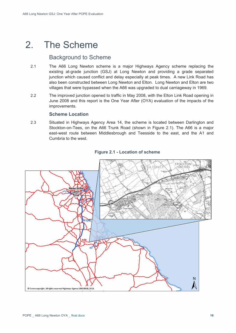
Stockton-on-Tees, on the A66 Trunk Road (shown in Figure 2.1). The A66 is a major east-west route between Middlesbrough and Teesside to the east, and the A1 and Cumbria to the west.
Figure 2.1 - Location of scheme

A66 Long Newton GSJ: One Year After POPE Evaluation
POPE _ A66 Long Newton OYA _ final.docx 17
Problems Prior to the Scheme 2.4 Over the years, the traffic volumes and speeds on this dual carriageway route between
Middlesbrough and Darlington have increased, and as a result all junctions east of Elton are now grade-separated junctions. The increased volumes and speeds resulted in conflict and delay at peak times at the at-grade junctions at Long Newton.
2.5 Since the 1980’s there has been a significant number of accidents on this section of the A66, many concerned with the at-grade junctions and central reserve crossings associated with them. There were numerous private and field accesses directly onto the busy trunk road, which further increased conflict with traffic on the A66.
2.6 No direct bus service operated between the two villages of Long Newton and Elton, meaning villagers without private transport had to walk between the villages. The service was removed by the operator in September 2002 due to concerns over safety when crossing the A66. Prior to the improvements people in Long Newton “had to face a long journey to Stockton and found it impossible to get to Darlington.” (Evening Gazette, December 2003).
Objectives of the Scheme 2.7 The main aims of the scheme were to enhance road safety and reduce delays whilst
providing value for money and minimising the effect on the environment. The scheme was also designed to provide a gateway access to Durham Tees Valley Airport for traffic travelling to and from the surrounding areas. The continued expansion of the Airport required a new access from the A66, to remove the need for traffic to use the local highway network. A new grade separated junction west of Long Newton would provide access to the improved section of Mill Lane leading to the Airport.
2.8 The primary objectives of the scheme (taken from the HA Public Inquiry Statement of Case evidence) were therefore to:
� Improve road safety on the A66;
� Reduce traffic volumes in the west end of Long Newton resulting from the re-routing of Airport traffic through the new junction;
� Increase provision for Public Transport facilities to both villages;
� Limit the impact of the improvement proposals on the surrounding environment; and
� Provide a safer route, affecting fewer properties, to the Airport.
Scheme Description 2.9 The scheme included the following elements:
� Complete closure of two at-grade junctions with the A66 at Long Newton West and Elton West;
� A new grade separated junction at Long Newton West;
� Closure of the central reserve gap at the Long Newton East junction to limit the number of turning movements;
� Closure of ten central reserve crossings, removing the need to carry out hazardous turning movements across the A66 (see Figure 2.2 for the Long Newton West junction before scheme construction, showing the central reserve crossing);

A66 Long Newton GSJ: One Year After POPE Evaluation
POPE _ A66 Long Newton OYA _ final.docx 18
� Closure of 26 private and field accesses direct onto the A66, with safer, alternative provision made;
� Re-routing of Airport traffic through the new junction;
� A Link Road between Long Newton and Elton to provide a route away from the A66 for local and agricultural traffic, buses, pedestrians and cyclists;
� Increase provisions for Public Transport facilities to both villages; and
� Traffic calming measures in Long Newton village.
2.10 The key features of the scheme are illustrated schematically in Figure 2.3.
Figure 2.2 – Long Newton West Central Reserve Gap (before scheme)
.

A66
Lon
g N
ewto
n G
SJ:
One
Yea
r Afte
r PO
PE
Eva
luat
ion
PO
PE
_ A
66 L
ong
New
ton
OYA
_ fi
nal.d
ocx
19
Figu
re 2
.3 –
Key
feat
ures
of t
he S
chem
e
Gap
sto
pped
up
Gap
sto
pped
up
Dar
lingt
on R
d C
lose
d
Junc
tion
mai
ntai
ned
as
left
in le
ft ou
t G
aps
stop
ped
up
Long
New
ton
Eas
t -
Junc
tion
mai
ntai
ned
as le
ft in
left
out
Gap
sto
pped
up
Gap
s st
oppe
d up
Junc
tion
mai
ntai
ned
as
left
in le
ft ou
t Elto
n W
est
Junc
tion
- Clo
sed
Gap
sto
pped
up
Long
New
ton
Wes
t -
New
Gra
de S
epar
ated
Ju
nctio
n
Gap
s st
oppe
d up
Roa
dS
topp
ed U
p
Long
New
ton
to E
lton
Link
Roa
d

A66 Long Newton GSJ: One Year After POPE Evaluation
POPE _ A66 Long Newton OYA _ final.docx 20
History of the Scheme 2.11 Table 2.1 summarises the history of the scheme.
Table 2.1 – Scheme History
Date Event
1980’s DfT Studies into Grade Separated Junction
January 1995 Slip and Side Road Orders published
February 1995 Compulsory Purchase Order published
September 1995 Public Inquiry
November 1996 Orders made following Secretary of State approval for scheme
October 1998 Orders re-published.
March 2001 Following delays to funding, Government accepts recommendation of the Regional Planning Body that the scheme should be
constructed as quickly as possible to assist job creation at nearby Durham Tees Valley Airport
October 2002 Improvements to the A66 at Long Newton included in the Targeted Programme of Improvements (TPI).
October 2002 Orders re-published
July 2003 2nd Public Inquiry
February 2005 Legal Orders to build the scheme and to purchase the land were formally made
February 2007 Highways Agency award contract to Interserve Project Services for detailed design and scheme construction.
June 2007 Major Construction Works started
2nd May 2008 Grade Separated Junction opens to traffic
5th June 2008 Long Newton to Elton Link Road opens to traffic

A66 Long Newton GSJ: One Year After POPE Evaluation
POPE _ A66 Long Newton OYA _ final.docx 21
Scheme Support 2.12 The junction scheme generally had
support from local councillors and residents who campaigned for over 20 years for the scheme, forming a group “Residents Against Interchange Delay”.
2.13 However, residents in Elton formed an “Elton Village No Link Road Action Group” to protest about the link between the two villages, whilst supporting the junction improvements. The group believed that the link would bring more traffic through the village of Elton travelling at high speeds and this would lead to safety concerns.
2.14 See Case Study 1 for media reporting on the scheme.
2.15 The OYA evaluation included a survey of residents (see section 3) in both villages and this included a question to ascertain residents’ level of support for the scheme. Residents were asked whether they supported or opposed 3 elements of the scheme, namely:
� The Grade Separated Junction,
� The Long Newton to Elton Link Road; and
� Central Reserve Gap Closures on the A66.
2.16 A summary of the responses to the questions is shown in Table 2.2
Case Study 1 – Media Reports of Scheme
Villagers Split as link gets go ahead
‘The decision to reopen a road linking two Teesside villages met with mixed reactions today. Opinion is split between residents of Long Newton and Elton over the proposals to build a link road and improve a notorious blackspot on the A66.’ Evening Gazette (13/12/2003)
Residents Cheer as work finally begins on death mile
‘Villagers living near a stretch of the A66 named "death mile" have welcomed the start of work to improve safety Residents clapped and cheered as a turf-cutting ceremony took place to mark the beginning of the £12m Long Newton junction scheme between Darlington and Stockton.’ Northern Echo (06/04/2007)

A66 Long Newton GSJ: One Year After POPE Evaluation
POPE _ A66 Long Newton OYA _ final.docx 22
Table 2.2 - Scheme Support
In Favour/Opposed to: Village In favour Opposed Don’tKnow
Long Newton (west) 42 (91%) 3 (7%) 1 (2%)
Long Newton (east) 43 (98%) 0 1 (2%)
Elton 9 (82%) 1 (9%) 1 (9%) Grade Separated Junction improvement
Total 94 (93%) 4 (4%) 3 (3%)
Long Newton (west) 41 (91%) 1 (2%) 3 (7%)
Long Newton (east) 40 (91%) 1 (2%) 3 (7%)
Elton 2 (18%) 8 (73%) 1 (9%) Long Newton to Elton Road
Total 83 (83%) 10 (10%) 7 (7%)
Long Newton (west) 40 (89%) 4 (9%) 1 (2%)
Long Newton (east) 44 (100%) 0 0
Elton 7 (64%) 2 (18%) 2 (18%) Central Reserve Gap Closures on A66
Total 91 (91%) 6 (6%) 3 (3%)
2.17 The table shows:
� Over 90% of all respondents were in favour of the GSJ and Gap Closures, with 83% in favour of the Elton Link Road;
� Support for all 3 attributes of the scheme was higher in Long Newton than in Elton village; and
� This is particularly the case for the Link Road, where almost 75% of Elton respondents were opposed to that part of the scheme, although this is from a small sample size.
2.18 For those respondents outside of the two villages, support was high (around 80% in favour) for both the new junction and Elton Link Road. Support was lower for the Gap Closures with just over 60% in favour, but around 30% were opposed.
2.19 Most of the respondents in favour of the GSJ and Gap Closures and who provided comments cited expected safety improvements as the reason for their support. A small number of those who opposed the Gap Closures made comments and their concerns were expected increases in journey times for some journeys. This was especially the case for people located outside of the two villages on Back Lane and Coatham Lane.
2.20 The Elton Link Road was supported as it would provide improved connections between the two villages and also allow re-instatement of bus services. Elton respondents who opposed the Link Road cited expected increases in traffic flows and speeds.

A66 Long Newton GSJ: One Year After POPE Evaluation
POPE _ A66 Long Newton OYA _ final.docx 23
3. Data Collection Introduction
3.1 This section of the report outlines the details of the traffic surveys carried out and other data to support the preparation of this One Year After Study.
Data Sources 3.2 The report uses data from a number of sources which provide a variety of information. As
part of the ‘before’ and ‘after’ monitoring for this scheme, information was obtained from the following sources:
� Permanent count data from Highways Agency sites (TRADs);
� Count data supplied by Stockton-on-Tees Borough Council;
� Temporary count surveys commissioned by the POPE Team;
� Journey time surveys commissioned by the POPE Team;
� Accident data supplied by Stockton-On-Tees Borough Council and A-One (Area 14 Mac); and
� Consultation and residents survey responses.
Traffic Count Data 3.3 Counts were undertaken before the opening of the scheme. The same locations have
been used for the after surveys to assess any changes that may be as a result of the schemes implementation, but with some additional counts at the new junction. Traffic data was collected at the following intervals for two weeks:
� March 2007 (before scheme opening); and
� June/July 2009 (one year after opening).
Count Locations3.4 Individual count locations local to the scheme are listed in Table 3.1 together with the
source of the data for the ‘before’ and ‘after’ monitoring data. For ease of reference, each location has been given a Count Site reference and these are shown geographically in Figure 3.1.
3.5 Wider area traffic flows were taken from TRADs and Stockton-on-Tees BC sites and these are listed in Table 3.2 and shown geographically on Figure 3.1.

A66
Lon
g N
ewto
n G
SJ:
One
Yea
r Afte
r PO
PE
Eva
luat
ion
PO
PE
_ A
66 L
ong
New
ton
OYA
_ fi
nal.d
ocx
24
Figu
re 3
.1 –
Tra
ffic
Cou
nt L
ocat
ions

A66 Long Newton GSJ: One Year After POPE Evaluation
POPE _ A66 Long Newton OYA _ final.docx 25
Table 3.1 – Local Count Sites
CountSite
Description Source‘before’
Date of ‘before’surveys
Source‘OYA’
Date of ‘OYA’
surveys
1 New Darlington Road Link , from New Roundabout
POPE Team Temp
March2007
AtkinsTemp
June2009
2 Long Newton Lane, south east of Darlington Road
POPE Team Temp
March2007
AtkinsTemp
June2009
3 Darlington Road Link, between White House Croft and A66 Long Newton East junction
POPE Team Temp
March2007
AtkinsTemp
June2009
4 Sandy Leas Lane to the north of the A66 POPE Team Temp
March2007
AtkinsTemp
June2009
5 Darlington Road, between Coatham Lane and A66
POPE Team Temp
March2007
AtkinsTemp
June2009
6 Mill Lane, south of Old Mill Lane tie-in POPE Team Temp
March2007
AtkinsTemp
June2009
7 A66 Westbound off Slip on the new GSJ POPE Team Temp
- Atkins Temp
June2009
8 New A66 Eastbound on Slip on the new GSJ (north of the over bridge)
POPE Team Temp
- Atkins Temp
June2009
Table 3.2 – Wider Area Count Sites
CountSite
Description Source‘before’
Date of ‘before’surveys
Source‘OYA’
Date of ‘OYA’
surveys
9 A66, A1150-A135, east of Elton Interchange TRADs March 2007
Trads June 2009
10 A66, A1150-A135, Great Burdon TRADs March 2007
Trads June 2009
11 A66 between A67 near Darlington East and South (Darlington Football Stadium)
TRADs March 2007
Trads June 2009
12 A66 between A67 near Darlington East and A1150
TRADs March 2007
Trads June 2009
13 A66 between A1150 and A135 (Long Newton Reservoir)
TRADs March 2007
Trads June 2009
14 A66 within A135 Junction TRADs March 2007
Trads June 2009
15 A135 Yarm Road, north of Preston Park Stockton-on-Tees BC
June 2006 Stockton-on-Tees
BC
June2009
16 A67 East of Airport Entrance Stockton-on-Tees BC
May 2006 Stockton-on-Tees
BC
Oct 2008

A66 Long Newton GSJ: One Year After POPE Evaluation
POPE _ A66 Long Newton OYA _ final.docx 26
Journey Times 3.6 Journey time surveys were conducted before and after the scheme opened to
quantifiably estimate any time savings due to the new scheme. Journey times were surveyed over a loop to and from the A67/ Durham Tees Valley Airport access roundabout, via Mill Lane, A66 and A135, as shown on Figure 3.2.
3.7 Journey time surveys were undertaken in March 2007 before construction and in June 2009, one year after opening.
3.8 The surveys were undertaken using the moving observer method on weekdays (Tuesday-Thursday) for the following time periods:
� AM Peak (0800-0900);
� Inter-Peak (1000-1500); and
� PM Peak (1700-1800)
3.9 At least six journey time runs in each time period and by direction of travel were conducted.
Figure 3.2 – Journey Time Routes and Timing points
3.10 In addition, journey times were also recorded through Elton village to Long Newton, using the Elton Link Road, as shown in Figure 3.2. These can be compared to the journey times via the A66.

A66 Long Newton GSJ: One Year After POPE Evaluation
POPE _ A66 Long Newton OYA _ final.docx 27
Accident Data 3.11 Stockton-On-Tees Borough Council and A-One+ (Area 14 MAC) have supplied accident
data for the five years prior to scheme opening and the one year after, for the area shown on Figure 3.3. This is the same area as used in the scheme appraisal. The accident data covers all recorded Personal Injury Accidents (PIAs), including details of the severity of casualty injuries (slight, serious, fatal) recorded in the STATS19 data collected by the local police when attending accidents.
Figure 3.3 – Accident Analysis Area
Traffic and Economic Forecasts 3.12 The following documents have been used in the preparation of the traffic and economic
sections of the report:
� Appraisal Summary Table (AST), July 2006 (Appendix A);
� Traffic and Economics Technical Note 2: Version 1.2 Forecasting Report, September 2008 update (Atkins);
� COBA files; and
� Current scheme costs from the Highways Agency (as of February 2010).
Environmental Data 3.13 The following documents have been used in the preparation of the environmental section
of the report (see Appendix E):
� A66(T) Long Newton Grade Separated Junction Environmental Statement January 1995;
� AST July 2006 version;

A66 Long Newton GSJ: One Year After POPE Evaluation
POPE _ A66 Long Newton OYA _ final.docx 28
� Supplementary Environmental Assessment Review October 2002;
� HA Statement of Case 2003;
� Environmental Evidence for Public Inquiry 2003;
� Updated ecological surveys 2006 and 2007;
� Draft ‘As Built’ drawings for landscape and ecology Revision AB 2009;
� Archaeology Watching Brief report; and
� Scheme newsletters.
Consultation3.14 A number of the DfT’s appraisal objectives are difficult to quantify. In order to address
this, a residents’ survey was conducted during December 2009 to elicit the views of the local residents in Long Newton and Elton villages. The survey collected views on a number of issues relating to quality of life, severance, accessibility and environmental impacts.
3.15 Figure 3.4 shows the area covered by the survey. Long Newton was split into two, east and west to separate residents who are closer to the new junction from the rest of the village. In addition, survey forms were sent to 46 outlying properties, including a number of farms, not in the two villages, but where the scheme may have impacted on the household.
Figure 3.4 – Residents’ survey Boundary

A66 Long Newton GSJ: One Year After POPE Evaluation
POPE _ A66 Long Newton OYA _ final.docx 29
3.16 A copy of the survey questionnaire used is included in Appendix B. Table 3.3 shows the response rate from the residents’ survey in the villages and outlying properties. In total 376 forms were delivered, 118 were returned giving a response rate of 31%. This is in line with other recent surveys carried out for POPE.
Table 3.3 – Residents Survey Response Rate
Village Forms Distributed Forms Returned Response Rate
Long Newton (west) 106 47 44%
Long Newton (east) 181 44 24%
Elton 43 11 26%
Outlying Properties 46 16 35%
TOTAL 376 118 31%
3.17 The results of the consultation are included in the relevant chapters of the report. Where comments are included in the report they are representative of views held by a large number of respondents.