port of pittsburgh commission (ppc) · port of pittsburgh commission (ppc) ... radius, a 6 mbps...
TRANSCRIPT
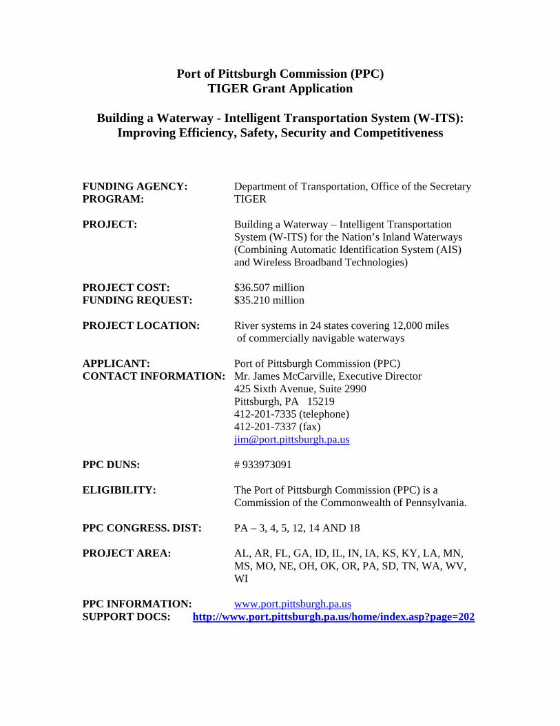
Port of Pittsburgh Commission (PPC) TIGER Grant Application
Building a Waterway - Intelligent Transportation System (W-ITS):
Improving Efficiency, Safety, Security and Competitiveness
FUNDING AGENCY: Department of Transportation, Office of the Secretary PROGRAM: TIGER PROJECT: Building a Waterway – Intelligent Transportation
System (W-ITS) for the Nation’s Inland Waterways (Combining Automatic Identification System (AIS) and Wireless Broadband Technologies)
PROJECT COST: $36.507 million FUNDING REQUEST: $35.210 million PROJECT LOCATION: River systems in 24 states covering 12,000 miles of commercially navigable waterways APPLICANT: Port of Pittsburgh Commission (PPC) CONTACT INFORMATION: Mr. James McCarville, Executive Director 425 Sixth Avenue, Suite 2990 Pittsburgh, PA 15219 412-201-7335 (telephone) 412-201-7337 (fax) [email protected] PPC DUNS: # 933973091 ELIGIBILITY: The Port of Pittsburgh Commission (PPC) is a
Commission of the Commonwealth of Pennsylvania. PPC CONGRESS. DIST: PA – 3, 4, 5, 12, 14 AND 18 PROJECT AREA: AL, AR, FL, GA, ID, IL, IN, IA, KS, KY, LA, MN,
MS, MO, NE, OH, OK, OR, PA, SD, TN, WA, WV, WI
PPC INFORMATION: www.port.pittsburgh.pa.us SUPPORT DOCS: http://www.port.pittsburgh.pa.us/home/index.asp?page=202

1
Project Narrative
I. Summary
This project would fund the deployment of two proven transportation communication technologies at locations throughout the nation’s Inland Waterway Transportation System (Waterways). It would enable faster, better and more reliable collection and transmission of data. The data gathered and transmitted would change operational patterns and transform both public and private decision-making. This would create a platform for a safer and more secure, more efficient and more competitive waterway system and create a more efficient and competitive system of multi-modal transportation in and out of the port terminals.
II. Overview
The nation’s Waterways consist of 12,000 miles of commercially navigable rivers comprising 27 river systems in 38 states moving $70 billion in cargo annually through 200 sets of locks and dams. The Waterways move 14% of the nation’s intercity freight, approximately 624 million tons of cargo a year (Bureau of Transportation Statistics). The US Army Corps of Engineers (USACE) expects that number to increase. Maintaining even the existing volumes, and any additional growth, requires the optimal utilization of road, rail, and waterway capacities and the integration of digital communications to reduce congestion, conserve energy, protect the environment and improve safety, security efficiency and competitiveness. The Waterways, when operating efficiently, can alleviate the need for highway expansion and reduce environmental degradation. When operating inefficiently, they place additional stresses on the other modes. Barging is the least expensive mode of surface transportation for the private sector, plus it has significant public benefits, consuming less fuel and emitting fewer emissions than trucks and trains. The Waterways provide the most energy efficient mode of travel with a barge moving one ton of cargo 576 miles per gallon of fuel -- compared to 413 miles by rail and 155 miles by truck -- with fewer accidents, fatalities, oil spills and emissions than rail or trucks moving comparable ton-miles. While the Waterways offer opportunities to efficiently move even more freight, they also face impediments. Structural expansion of the system is costly and impractical and the aging lock and dam infrastructure requires all of the inland navigation resources normally available to USACE, just to maintain and rehabilitate key parts of the system.
ncesThe National Academy of Scie
1, the General Accounting Office2 and the Committee
1 Inland Naviga emy Press tion System Planning: The Upper Mississippi River-Illinois Waterway, National Acad
duhttp://www.nap.e , 2001 National Academy of Sciences 2 GAO‐07‐55T, Transportation Challenges Facing Congress and the Department of Transportation, March 6, 2007
2
developed with the additional
on the Marine Transportation System3 (CMTS), have all stressed the importance of seeking non-structural alternatives for waterway improvements. This project is a non-structural way to make the “greenest”, most economical form of surface transportation safer, more efficient and even more environmentally friendly. Digital communications on the Waterways, to date, have not been modernized to take full advantage of other technology developments. Cell phone air cards have limited bandwidth with spotty coverage in rural areas. Satellite connections have sufficient bandwidth, but are expensive and impractical for transmission of large amounts of data. Some pilots still make handwritten reports to hand-pass to each lockmaster as they transit through each lock, a time when both the pilot and the lock operator should be concerned with other tasks. These handwritten reports are frequently inaccurate, requiring time-consuming USACE data reconciliation. The communications technology described in this proposal would transform waterway operations and lead to better decision-making in both the private and public sector. The American Waterway Operators (AWO) has reviewed this project and believes it is consistent with their goal to improve the efficiency, safety, security and competitiveness of the Waterways in the global marketplace. USACE has endorsed the project and will provide technical advice to maximize its economic advantages during its deployment. Both have submitted letters of support found in the Appendices 2 and 3.
III. Proposal The Port of Pittsburgh Commission proposes to deploy a Waterway-Intelligent Transportation System (hereafter called “Waterway-ITS” or “W-ITS”) platform, innovatively combining the advantages of two proven technologies: the Automatic Identification System (AIS) and the wireless broadband. This platform opens up a world of high-speed, two-way digital communication possibilities between pilots of different vessels; between pilots and port and/or lock operators; between pilots and their home office; and between home offices and government. It would also speed up cargo identification and determination of exact cargo location, essential information for coordinating barge shipments with rail or truck pickups. AIS. AIS is a short range tracking system used for identifying and locating vessels by electronically exchanging data with other nearby vessels and Vessel Tracking Stations. Information such as unique identification, position, course and speed can be displayed on a screen or an Electronic Navigation Chart. AIS assists the vessel's crew and allows maritime authorities to track and monitor critical vessel movements. AIS was also
ability to broadcast positions and names of objects like
3 Transpo
A Framework for Action: National Strategy for the Marine Transportation System July 2008, Committee on Marine rtation System:

3
navigational aid and marker position, including potential future virtual aids to navigation. The International Maritime Organization's (IMO), International Convention for the Safety of Life at Sea (SOLAS) already requires AIS to be fitted aboard international voyaging ships with 300 or more Gross Tons.4
The US Coast Guard (USCG) has now installed AIS Phase I Receivers at major
coastal seaports and is currently upgrading these seaport stations to Phase II Transponders for navigation safety and homeland security purposes. The seaport upgrades will take many years. The Inland Waterways are not currently scheduled for any AIS installation by the USCG, but the W-ITS project, coordinated with USCG, would take advantage of their Phase II technology.
Commercial vessels, to participate in W-ITS, would have to install an AIS transponder at their own cost, to broadcast key vessel information, such as any hazardous cargo onboard, estimated time of arrival and destination, and other safety and voyage-related information. Many waterway vessels, especially those that also operate in coastal ports like Houston and New Orleans, already have these transponders installed. Through two-way correspondence, the AIS would populate the vessel display with data about itself, other vessels in the area, nearby locks and other aids to navigation.
The cost of an AIS base station is $10,000 and installation at each site is estimated to cost $51,000, which includes mounting structures and connecting it to the internet to push data to a centralized server and to the USCG. USACE will provide in-kind support. Section III provides total cost for equipment, installation, and maintenance. Appendix B contains a letter from USACE endorsing this project and committing to provide access for its installation at their facilities. Figure 1 illustrates the base station components set up to receive vessel AIS transmissions. Although the USCG would like to deploy the AIS network, they are not currently funded to do so, nor do they, or any other federal agency, have the mission to deploy an integrated broadband network to support industry communications. Without TIGER funds, it will be impossible to deploy the W-ITS.
4http://en.wikipedia.org/wiki/Automatic_Identification_System

Figure 1 ‐ AIS
Wireless Broadband. The other W-ITS component is wireless broadband
communications to support vessel-to-vessel and vessel-to-shore two-way business and commerce transmissions. Figure 2 presents the concept. Carnegie Mellon University (CMU) has completed a report detailing the costs, practicality and benefits of deploying a wireless broadband system at 200 stations along The Waterways. The CMU study specifically recommended 3.65 GHz, public spectrum, WiMax technology, with a 3 mile radius, a 6 mbps downlink, a 1.5 mbps uplink and an RSA security encryption. WiMAX stands for Worldwide Interoperability for Microwave Access technology. The details of the CMU study, The Wireless Waterway, can be found at http://www.port.pittsburgh.pa.us/home/index.asp?page=180.
4
The Wireless Broadband is necessary because the bandwidth needs exceed that which is available on AIS. The wireless network is required to augment AIS with unrestricted, confidential communications and other applications. It may include cargo information required by USACE, updated nautical charts, crew timesheets, manifests,

crew e-mail, security camera streaming video, locking guidance, engine maintenance guidance, and other private uses over secure networks.
The per unit cost of the wireless broadband base station in $99,000. The station cost is $42,860, installation is estimated at $42,170 per site, and a contingency/miscellaneous cost of $13,970 per site.
Figure 2 Wireless Broadband Network (CMU, 2009)
Deployment. The combined W-ITS would be deployed at 200 locations on The Waterways, including 150 priority USACE locks and 50 additional sensitive river sites provided by USACE and/or USCG. It would be focused primarily on the 24 states that border the Mississippi, Illinois, Tennessee and Ohio Rivers (and their respective tributaries), and the Tenn-Tom, McClellan-Kerr and the Columbia-Snake Waterways, which includes 90% of the inland waterway traffic and about 10,000 of its 12,000 miles. The primary states affected are AL, AR, FL, GA, ID, IL, IN, IA, KS, KY, LA, MN, MS, MO, NE, OH, OK, OR, PA, SD, TN, WA, WV, WI.
5

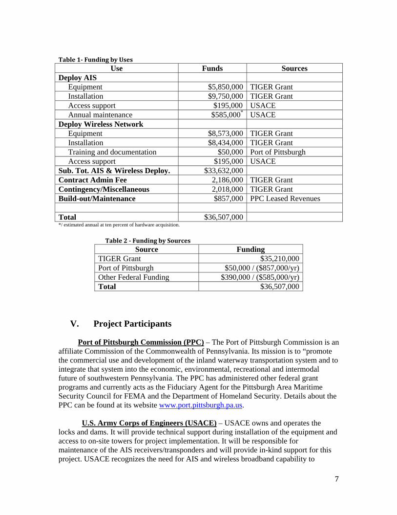
IV. Uses and Sources of Funds Total Project Costs. National deployment of the W-ITS network will cost $36,507,000, with $5,210,000 sought in TIGER Grant funds. The breakdown of funding by uses and sources is shown in Tables 1 and 2. USACE will provide the maintenance for the AIS system. The PPC will contract out all the work to reputable contractors, including deployment, maintenance and the management of the platform. The PPC, which has already invested $30,000 in the feasibility study by Carnegie Mellon University, will provide contractor oversight, asset management and maintenance and any future potential build out that may be possible from revenues to be obtained from leasing available bandwidth. No maintenance is anticipated in the first year. A contingency is included to cover any unanticipated events. No funds are needed for real estate or right of way acquisition, environmental permitting or construction, making this project ready to go.
6
7
Table 1 Funding by Uses
Use Funds Sources Deploy AIS Equipment $5,850,000 TIGER Grant Installation $9,750,000 TIGER Grant Access support $195,000 USACE Annual maintenance $585,000* USACE Deploy Wireless Network Equipment $8,573,000 TIGER Grant Installation $8,434,000 TIGER Grant Training and documentation $50,000 Port of Pittsburgh Access support $195,000 USACE Sub. Tot. AIS & Wireless Deploy. $33,632,000 Contract Admin Fee 2,186,000 TIGER Grant Contingency/Miscellaneous 2,018,000 TIGER Grant Build-out/Maintenance $857,000 PPC Leased Revenues Total $36,507,000 */ estimated annual at ten percent of hardware acquisition.
Table 2 Funding by Sources Source Funding
TIGER Grant $35,210,000 Port of Pittsburgh $50,000 / ($857,000/yr) Other Federal Funding $390,000 / ($585,000/yr) Total $36,507,000
V. Project Participants Port of Pittsburgh Commission (PPC) – The Port of Pittsburgh Commission is an affiliate Commission of the Commonwealth of Pennsylvania. Its mission is to “promote the commercial use and development of the inland waterway transportation system and to integrate that system into the economic, environmental, recreational and intermodal future of southwestern Pennsylvania. The PPC has administered other federal grant programs and currently acts as the Fiduciary Agent for the Pittsburgh Area Maritime Security Council for FEMA and the Department of Homeland Security. Details about the PPC can be found at its website www.port.pittsburgh.pa.us. U.S. Army Corps of Engineers (USACE) – USACE owns and operates the locks and dams. It will provide technical support during installation of the equipment and access to on-site towers for project implementation. It will be responsible for maintenance of the AIS receivers/transponders and will provide in-kind support for this project. USACE recognizes the need for AIS and wireless broadband capability to

8
modernize the waterways and to modernize their own Operations and Maintenance business practices. A letter of support from the USACE is included in the Appendix 2.
American Waterway Operators (AWO) – The AWO Technology Committee provided technical input into the development of this proposal and AWO, as an organization, supports its deployment. The AWO Technical Committee will continue to provide advice to optimize the utility of the deployment and will explore with the PPC effective strategies to build out the system after this initial deployment. A letter of support is contained in Appendix 3. U.S. Coast Guard (USCG) – USCG has been consulted to gain knowledge from their coastal AIS deployment, including invaluable information about electronics and lifecycle requirements which was used in the formulation of this proposal. They will continue to be a resource as these systems are designed and deployed. They will also obtain the AIS signals from the USACE for national use.
Carnegie Mellon University (CMU) -- CMU provided technical studies for the Port of Pittsburgh to design non-structural improvements to the waterway system. In the past decade, the PPC/CMU cooperative arrangement has resulted in (1) a virtual lock navigation system, called “SmartLock”, for which the PPC was granted US Patent; (2) a river communications architecture description, called “River-Net”; and, the previously referred to study for the “Wireless Waterway”, a detailed technical design for wireless broadband including technical feasibility, business strategy and life-cycle management plan. The Carnegie Mellon studies can be found on the PPC web page at http://www.port.pittsburgh.pa.us/home/index.asp?page=172. National Oceanic and Atmospheric Administration (NOAA) – NOAA is a partner in establishing electronic navigation capabilities for coastal ports. Although not directly contributing to this effort, they support many leveraged electronic navigation activities such as electronic charts, and PORTS real time measurements. Department of Homeland Security (DHS) – DHS and local Area Maritime Security Committees along the Waterways may take advantage of the network footprint established by the wireless broadband capability. The technology provides the potential to communicate streaming video to/from port facilities and Law Enforcement Communication Fusion Centers along the waterway.
VI. Direct Address of Selection Criteria
A. Primary Criteria - Long-Term Outcomes 1. State of Good Repair
• This proposal is consistent with recommendations, plans, intents and guidance
from the National Academy of Sciences, General Accounting Office, Committee
9
Congressional
on Marine Transportation, US Army Corps of Engineers and the American Waterway Operators.
• The capital and life cycle costs were developed with the experience of the USCG
in the deployment of the AIS and with the study from Carnegie Mellon University for the deployment of the wireless broadband. According to these sources the project is adequately capitalized with minimized life cycle costs. The AIS will be maintained by USACE. The wireless broadband will be maintained by the PPC from revenues derived from leasing available bandwidth. If the revenues are sufficient, the PPC, in consultation with AWO, will continue to build out the system.
• The project will upgrade waterway communications to take economical advantage
of modern broadband internet access and AIS technology. The communications upgrade will allow USACE and the towing industry to optimize the utility of the existing physical infrastructure.
• USACE will use this tool to better schedule repair work during times when no traffic is anticipated so that it will have more up time when traffic is present. USACE has agreed to provide PPC with annual reports on the efficacy of this project, which the PPC will submit to DOT for five years.
2. Economic Competiveness.
• The greatest increase in economic competitiveness will come from better
decision-making resulting from this project. USACE will have more timely data that relates to the allocation of its resources to prioritize maintenance and capital re-investments and in the deployment of its personnel overtime to manage and operated the locks. Towing companies will have better information allowing them to slow down to avoid lock queues and coordinate other modal transportation connections. In the future, Original Equipment Manufacturers (OEMs), with software to be developed, will be better able to monitor and even repair engine operations while vessels are underway, reducing the amount of engine out-of-service maintenance downtime.
• A 2007 Maritime Administration report said that America’s Marine Highway, including the 12,000 mile U.S. inland waterway system, is the most economical mode of surface transportation and one of our nation’s greatest resources, adding $5 billion dollars a year to the U.S. economy, employing nearly 4,000 modern towboats and more than 27,000 barges.5
• The part of the waterway system most impacted passes through 24 states and 60 Districts. The Congressional Districts that border this project have
5 The Maritime Administration and the U.S. Marine Transportation System: A Vision for the 21st Century. US Maritime Administration, 2007.

10
Freight Transp
an average below-poverty rate of 15% as opposed to the national average of 13.3%. Thus many of the installation jobs would be available in these below-poverty areas. A map indicating below-poverty congressional districts of the target area is included in Appendix 4.
• USACE estimates that the processes resulting from this grant would save 30 seconds per lockage. When multiplied by the total number of lockages, USACE estimates it would save them $400,000 annually. They also estimate that the accuracy of the new data would save $2,000,000 annually in data reconciliation costs. Additionally, the Operations Director of the USACE-Pittsburgh District estimates a savings of about 40 hours per lock per year in overtime saved. This would occur especially at low use locks, when an employee calls in sick and no replacement may not have to be ordered out for a full shift, because management would know whether vessels were expected to arrive or not. Likewise, it will allow USACE to better schedule routine maintenance to those hours when no vessels are expected, increasing the open availability of the locks when they are needed.
3. Livability
• This project will benefit the livability of all of the communities along the
waterway as efficiencies on the Waterways alleviate the need to increase adjacent roadside traffic congestion and pollution. It will improve the air we breathe by reducing the emission of towing vessels that will no longer need to race to the lock queue. It will also better coordinate pick-up and delivery times with other modes, also easing truck idling time.
4. Sustainability
• As the 2007 Maritime Administration report pointed out “The use of Marine Highways can reduce overall fuel consumption and limit the amount of air pollution”. 6 Without reliable Waterways, more cargo could be forced onto congested streets and highways.
• This was quantified by the Texas Transportation Institute report, A Modal Comparison of Freight Transportation Effects on the General Public, which shows that the Waterways consume less fuel, emit fewer pollutants and suffer fewer accidents and fatalities than any other surface mode. It documents that barges move a ton of cargo 576 miles a gallon compared to 155 by trucks; that each 15-barge tow takes the equivalent of 1,050 trucks off of the highway. Finally, the study shows that trucks emit 56% more NOx; 64% more Particulate Matter; 296% more CO; and 378% more CO2. (See A Modal Comparison of
ortation Effects on the General Public – study by Texas
6 The Maritime Administration and the U.S. Marine Transportation System: A Vision for the 21st Century. US Maritime Administration, 2007.

11
of
that the Waterwand have half t
Transportation Institute.)7 For St. Louis alone, surface transportation congestion could increase by 200 percent, traffic delays 500 percent, and highway maintenance by over 80 percent. The national cost cannot at present be estimated, but would easily go into the hundreds of millions.
• Providing accurate queuing times to tows removes the need to race to the next
lock to gain a preferred locking position. This practice alone should reduce fuel consumption by one percent of the approximately 500 million gallons of fuel used annually on the waterway system8. This one percent would save 5 million gallons, and at $3 per gallon it would yield a $15,000,000 savings annually. With each gallon producing 19.5 pounds of CO2, it would reduce emissions of CO29 by 97.5 million pounds or 48,750 tons annually. For every$10 in value per ton CO2 removed the benefits would be nearly $500,000. Given that the Energy Information Administration estimated a value (in 2006 dollars) of $61 for every ton of CO2 removed, the benefit here is calculated at $2,974,000, or $3,000,000 in benefits a year .10
• Towboat operators will be able to better comply on the vessel, with EPA requests
for detailed data, usually kept at company headquarters but required by EPA to be on-board the vessel, without extensive and impractical on-board filing cabinets.
5. Safety
• AIS technology will aid safety by reading the vessel identification and populating
tow tracking software at locks.
• Wireless broadband will aid safety by the increased capacity for transmission and exchange of electronic information, including: updated electronic navigation charts which show hazards and the most recent conditions, real time current and wind velocities and directions at lock entrances. This will aid the pilot’s lock approach, reduce allisions and reduce damage to the lock system. The system will also transmit management training videos and even streaming video on vessels and at port facilities so the pilot sees conditions in real time.
• The Texas Transportation Institute study showed, on a per-million-ton-mile basis, ays suffer only 1 fatality to every 155 highway-sector fatalities
he oil spills of trucks. 7 Texas Transportation Institute, A Modal Comparison of Freight Transportation Effects on the General Public 8 Plamer, Barry. Restoring Trust to the In The Waterways Trust Fund, The Waterways Council Inc, Propeller Club landQu rterly, Spring 2008
ttp://www.boatcarbonfootprint.com/ a
9 h10 A Report by the Center for Clean Air Policy, Transportation and Climate Change Program, Cost-Effective GHG
eductions through Smart Growth & Improved Transportation Choices: An economic case for investment of cap-nd-trade revenues. June 2009. (The estimate was prepared by EIA in an analysis of the Lieberman-Warner Climate ecurity Act.)
RaS

12
could be diale
• The same study showed that over a 10-year period, truck traffic on St. Louis
roadways would increase by 200 percent and traffic delays by nearly 500 percent. Fatalities on highways would increase by 45 percent. Any enhancement of the Waterways makes moving cargo by barge more attractive, reducing total accidents.
B. Secondary Criteria 1. Innovation
• The W-ITS innovation comes from the integration of the AIS and wireless
broadband technologies. It will improve data collection and, in turn, decision-making on the waterways. It will modernize business practices with existing software and it will drive the development of software in the future for improvements to waterway asset management, funding decisions, project-delivery monitoring, collaboration with state and local governments and non-traditional partners, and greater integration of waterway decision-making with other transportation modes and with other government agencies.
• AIS11 is a shipboard broadcast system that acts like a transponder, operating in the VHF maritime band, that is capable of handling well over 4,500 reports per minute and updates as often as every two seconds. Shipboard AIS devices use either Self-Organizing Time Division Multiple Access (SOTDMA) or Carrier-Sense Time Division Multiple Access (CSTDMA) technology.
• AIS provides information for an electronic pilothouse display system (e.g. radar, ECDIS, chart plotter, etc.) with overlaid electronic chart data that includes a mark for every significant tow within radio range, including a velocity vector (indicating speed and heading)12. Each tow "mark" could reflect the actual size of the tow, with position to GPS or differential GPS accuracy. By "clicking" on a tow mark, you could learn the tow name, course and speed, classification, call sign, registration number, MMSI, and other information. Maneuvering information, closest point of approach (CPA), time to closest point of approach (TCPA) and other navigation information, more accurate and timely than information available from an automatic radar plotting aid, could also be available.
• Information previously available only to modern Vessel Traffic Service operations centers displays could now be available to every AIS-equipped vessel. With this information, any tow could be called over VHF radiotelephone by name, rather than by "down-bound tow" or some other imprecise means. Or it
directly using d
GMDSS equipment. Or short safety-related email
11 47 CFR 80.5, AIS Definition 12 U.S. Coast Guard, http://www.navcen.uscg.gov/enav/ais
13
messages could be exchanged.
• WiMAX is a wireless broadband technology that provides wireless long-distance broadband access for a variety of applications. The WiMAX Forum promotes conformance and interoperability of the standard IEEE 802.16. At first glance, WiMAX would seem similar to 3G cellular technologies, since both these networks can transmit data and voice, but by design, cellular 3G is voice-centric while WiMAX is data-centric. An IP based WiMAX network has three parts: Customer Premises Equipment (CPE), Access Service Network (ASN) and Connectivity Service Network (CSN).13 WiMAX or the latest LTE or 4G technology will be deployed based on the timing of the actual proposal.
• CPE can be compared with a modem in DSL but it needs to capture a wireless signal and it has thus an attached or integrated antenna. Best performance is reached by using a roof-mounted outdoor CPE. The signal is then brought to the end user computer using in-house Ethernet cabling or a Wi-Fi access point. An ASN consists of one or more base stations, and at least one instance of an ASN Gateway (ASN-GW). The base station primarily has radio related functions and ASN-GW is mainly for connection between different ASNs, between an ASN and CSN and between base stations in the same ASN. The CSN is defined as a set of network functions that provide IP connectivity services to the WiMAX subscribers. A CSN typically is comprised of several network elements such as routers, AAA proxy/servers, user databases, and Interworking gateway devices.
• With an AIS and wireless network both industry and government will be able to
actively manage traffic. Industry will know the locations of their tows in real time and be able to route and reroute them to efficiently integrate with surface transportation. Government will be able to actively manage traffic by queuing tows to alleviate congestion and more efficiently move tows through the waterway system.
• By recording data about each tow and its cargo, the government will have more
accurate information to make asset management decisions regarding repairs through a performance based methodology. Heretofore, recording lock and waterway use has been performed by hand, transcribing it on paper and later transcribing to a database. This creates many inaccuracies and omissions. W-ITS capabilities will improve and modernize business practices allowing for improved practices and database management decisions, which, in turn, will improve the long-term operations and maintenance of the inland waterway system.
2. Job Creation, Economic Stimulus and Compliances
13 The Wireless Waterway Project, Carnegie Mellon University, MSIT eBusiness, August 2009
14
well as increas
• Short-term jobs. Since no real estate or environmental clearances will be required, short-term jobs will be immediately created in the manufacturer, installation and maintenance of the electronics components for the AIS and wireless stations. Many of these jobs will be potentially available to low-income workers, since the area of the project has a higher than average percent of persons living below the poverty level. Employment will be through contractors retained by the PPC. As an entity of the Commonwealth of Pennsylvania, the PPC complies with Equal Opportunity and Civil Rights laws and requires the payment of prevailing wages in its government contracts. The PPC has a proven record on labor practices and compliance with Federal laws ensuring that American workers are safe and treated fairly. Our goals include maximizing work with small and disadvantaged businesses and community-based organizations. PA Governor Rendell has specifically asked that we make extra efforts to include small and disadvantaged businesses. The PPC will observe guidelines from Federal Wage Rate Certification, the National Environmental Policy Act, and environmentally related federal, state and local regulations. The PPC will require strict adherence to these provisions by its contractors and sub-contractors.
• No confidential business information is contained in this proposal.
• The 60 Congressional Districts that border this project have an average below-poverty rate of 15% as opposed to the national average of 13.3%.
• The PPC has the legal authority to undertake this project. No additional legislative
or environmental approvals or state or local planning approvals are necessary. A PPC authorizing resolution is attached in Appendix 5.
• The CMU report demonstrates the technical and financial feasibility of the project
and includes project detail. The AIS and (3G) wireless networks already exist. Experienced companies will be contracted with for deployment14.
• No long-term jobs will be lost and new jobs will develop as the inland waterway system becomes more attractive. Efficiencies in the system, due to this project, are estimated at 1%. Long term growth, because of a more efficient system, are estimated at 5% over normal growth, over a ten year period. If the waterway is not efficient and safe the impact to our economic growth will be severe, directly reducing the 2.5 million jobs in the water transportation and port services sector15. It would also shift congestion to other modes of transportation.
• The principal industries benefiting from the waterways are agriculture, mining,
power generation, metal making and chemical making. Any improvement in the efficiency of the waterways will result to the benefit of jobs in these industries, as
es in the towing and port terminaling businesses. Dr. John, Martin
14 The Wireless Waterway Project, Carnegie Mellon University, MSIT eBusiness, August 2009 15 U.S. Department of Transportation, Maritime Administration, U.S. Water Transportation Statistical Snapshot, May 2008

15
of Martin Associates, Inc. estimates that the total annual inland waterway system contributes an economic value of $137 billion a year to the economy.16 A one percent improvement in the efficiency of the system is expected to yield a $1.4 billion benefit to the nation, mostly to be realized in these key industries. With additional efficiencies and growth on the waterways, the key industries are expected to see a 5% growth over normal growth, which would yield a $7 billion contribution to the national economy. Even if we use the lower 1% benefit rate, this proposal exceeds any known benefit/cost threshold for deciding funding.
• For the foreseeable future, capital re-investment in the inland waterway
infrastructure will be constrained to priority projects only.17 With structural underinvestment, the locks will get older. They will be more in need of up-to-date information to monitor their use and condition and they will need more repairs. This project will help reduce unscheduled downtime due to allisions and collisions at the lock and will reduce the downtime of scheduled maintenance, by completing that work when no vessels are expected to arrive.
• It will also better coordinate rail and truck cargo arrivals with barge deliveries.
• Without the W-ITS infrastructure, long-term growth will be inhibited because
high risk and low reliability on the inland waterway system will result in an undesirable increase of surface transportation and congestion. This will increase energy consumption and adversely impact the environment18.
VII. Examples of Applications
Once established, the W-ITS network platform will support modernization of
business work flows by industry and the government, based on the following functions across the marine transportation community: 1. Improved logistics communications between the towing companies, the port
terminals and surface transportation providers. Barge voyage plans change. They are impacted by natural and man-made events, including flooding, icing, and scheduled and unscheduled lock repairs and maintenance as well as changes in business relationships. They impact on logistic decisions of port terminal operators and the connecting surface transportation providers, currently resulting in unnecessary idle time for docks, trucks and trains. More efficiently communicating changes, including expected pick-up and delivery times, cargo handling requirements and e-invoicing, would reduce uncertainty and improve competitiveness throughout the nation’s supply chain.
16 Martin, John, American Association of Port Authorities, Seaport Magazine, Summer 2009
eptember 2008
17 Inland Marine Transportation System Improvement Report, U.S. Army Corps of Engineers, S18 The Wireless Waterway Project, Carnegie Mellon University, MSIT eBusiness, August 2009

16
2. Improved communications between the pilots and the lock operators. Pilots currently tend to race with each other to be first in the lock queue. They prepare cargo data sheets for each lock, sometimes transmitting it by hand to the lock operator. The data is frequently inaccurate. The lock operators, not knowing when to expect vessels, have to announce pre-scheduled maintenance as lock closures. Better voyage planning information would allow for more predictable scheduling of lockages. This predictability, in turn, would allow the pilots to slow down at times, conserving fuel and reducing emissions. It would allow USACE to perform much of its maintenance when no vessels are expected, reducing the need to declare many of its maintenance closures. The more accurate data, prepared and filed from the dispatcher instead of the pilot, would eliminate much of the costly data reconciliation that currently delays the publication of USACE cargo reports. USACE could also provide the pilots with real time meteorological (wind speed and direction, visibility, etc) and hydrographic conditions (current velocities, etc) at lock approaches. This will aid the pilot on approaches, thus reducing allisions, which causes lock damage and depending on severity of the allision, very costly unscheduled closures. With approach vectors, precise location of hazards, and other real time electronic navigation chart information, the pilot, optimizing his lock approach, will reduce allisions, lock damage, and unscheduled closures.
3. Improved communications between pilots. On a single electronic navigation chart,
real-time locations of each commercial vessel will be visible with name, speed, and direction. Pilots will be able to accurately locate all such commercial vessels and exchange safe passing information. This capability exists now at coastal ports, and will be extended to the inland waterway system with AIS.
4. Improved communications between the pilots and home offices. Confidential and
proprietary information and data may be securely transmitted via the broadband network providing a private communication link. This may include updated electronic charts, company training manuals or directives or changes in business/delivery arrangements.
5. Improved communications between the home office and government. The
government collects key data on waterway usage and shipment of hazardous material. With this secure network, information, both public and proprietary may be rapidly shared in a secure environment. This reduces the cost of collecting and analyzing waterway use data, which today lags two years to produce final results. The increase in efficiency comes from much faster and accurate analysis of data and waterway system response. Also, shifting some of the communications from pilot to government (lock operator) and the internet improves the safety of the locking process, reducing the downtime at a lock to investigate incidents.

17
Table 3 Benefits a. Improved Condition $1,400,000,000b. Long-Term Growth $7,000,000,000c. Improved Livability Not calculated d. Improved Energy Efficiency $15,000,000e. Reduced CO2 Emissions $3,000,000 f. Reduced Surface Fatalities Not calculated g. Greater Project Delivery Not calculated h. Greater Collaboration Not calculated i. Greater Decision Making Not calculated Total measured by $ $8,403,000,000 When compared with a grant cost of $35,210,000 the project has a benefit/cost ratio of 240/1. The energy savings alone would justify this project in less than three years.
Table 4 Project Schedule
Item Day Receive TIGER funds 0 Finalize plan and designs . specifications for AIS transceivers . specifications for broadband transceivers . identify locations where equipment will be installed . IT infrastructure
10
Issue RFP / AIS . develop SOW for AIS installation . issue public notice for competitive bid process . support questions from potential bidders
10
Issue RFP / Wireless . develop SOW for AIS installation . issue public notice for competitive bid process . support questions from potential bidders
10
Award AIS contract . develop selection criteria . review and evaluate bids . select best proposal . finalize negotiations
50
Award Wireless contract . develop selection criteria . review and evaluate bids . select best proposal . finalize negotiations
50
Manufacture AIS equipment . award contract to manufacturer . inspect quality
110
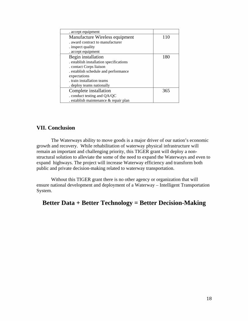
18
. accept equipment Manufacture Wireless equipment . award contract to manufacturer . inspect quality . accept equipment
110
Begin installation . establish installation specifications . contact Corps liaison . establish schedule and performance expectations . train installation teams . deploy teams nationally
180
Complete installation . conduct testing and QA/QC . establish maintenance & repair plan
365
VII. Conclusion
The Waterways ability to move goods is a major driver of our nation’s economic growth and recovery. While rehabilitation of waterway physical infrastructure will remain an important and challenging priority, this TIGER grant will deploy a non-structural solution to alleviate the some of the need to expand the Waterways and even to expand highways. The project will increase Waterway efficiency and transform both public and private decision-making related to waterway transportation.
Without this TIGER grant there is no other agency or organization that will
ensure national development and deployment of a Waterway – Intelligent Transportation System.
Better Data + Better Technology = Better Decision-Making

Figure 4, Locks for Potential AIS and Wireless Sites
19

Appendix 2 U.S. Army Corps of Engineers Letter of Cooperation
20

Appendix 3
September 14, 2009 Mr. James R. McCarville
n Executive Director
missio 2990
Port of Pittsburgh Com25 6th Avenue, Roomittsburgh, PA 15219 4P
RE: Building a Waterway ‐‐ Intelligent Transportation System (W‐ITS): Improving Efficiency, Safety, Security and Competitiveness
Dear Mr. McCarville: The American Waterways Operators (AWO) is the national trade association for the inland and coastal tugboat, towboat and barge industry. AWO’s members account for approximately 80 percent of the barge tonnage and two‐thirds of the towing vessel horsepower in this critical industry segment, moving coal, grain, petroleum products, chemicals, steel, aggregates and containers on the inland rivers, the Atlantic, Pacific and Gulf coasts, and on the Great Lakes. We represent the safest, most efficient and most environmentally friendly form of freight transportation. More than 33,000 people are employed aboard tugs and owboats, accounting for the largest number of jobs in the U.S. merchant t
21
marine. In August, the Port of Pittsburgh Commission invited the AWO Technology Steering Group to participate in meetings hosted by the

Carnegie Mellon University team responsible for developing the technical infrastructure to support the Intelligent Transportation System (W‐ITS). At these meetings, participating AWO members were briefed on the goals and objectives of the project and were given the opportunity to comment on its conceptual direction. We appreciate the Port of Pittsburgh ommission’s interest in receiving feedback from our member experts on Cthis concept. Based on feedback we have received from members of the Technology Steering Group, AWO believes that should the goals outlined in the W‐ITS proposal be realized, it would result in considerable benefit to the efficiency, safety, security and competitiveness of vessel operations on the inland rivers. AWO is a strong advocate for improving the means of communication and data transmission within the tugboat, towboat and arge industry, and it is our opinion that the goals of the W‐ITS project bare consistent with those objectives.
very much for your consideration. Thank you
incerely, S
Thomas Allegretti
22

Appendix 4
23
