port of moses lake development: terex and chemi-con properties · environmental checklist 2 port of...
TRANSCRIPT

ENVIRONMENTAL CHECKLIST
for the
Port of Moses Lake Development:
Terex and Chemi-Con Properties
prepared for
Port of Moses Lake
January 2017
EA Engineering, Science, and Technology, Inc., PBC
Reid Middleton, Inc. Heffron Transportation, Inc.

PREFACE--
The purpose of this Environmental Checklist is to identify and evaluate probable environmental impacts that could result from the Port of Moses Lake Development Project – Terex and Chemi-Con Properties, and to identify measures to mitigate those impacts. The approximately 89.8-acre project site is comprised of three parcels that could accommodate approximately 241,368 sq. ft. of additional building area. For purposes of analysis, it is assumed that the buildings would be developed in heavy industrial uses.
The State Environmental Policy Act (SEPA)1 requires that all governmental agencies consider the
environmental impacts of a proposal before the proposal is decided upon. This Environmental Checklist has been prepared in compliance with the SEPA Rules, effective April 4, 1984, as amended (Chapter 197-11), Washington Administrative Code and Grant County’s SEPA Regulations (GCC 24.04). This Environmental Checklist is intended to serve as SEPA review for site preparation work, building construction and operation of the potential development of the Port of Moses Lake Development Project – Terex and Chemi-Con Properties. Analysis of the project contained in this Environmental Checklist is based on development information provided by the Port of Moses Lake and Reid Middleton. While not construction-level in detail, the information is considered adequate for purposes of analysis and disclosure of environmental impacts. This Environmental Checklist is organized into three major sections. Section A of the Checklist (starting on page 1) provides background information on the Proposed Action (e.g., purpose, proponent/contact person, project description, project location, etc.). Section B (beginning on page 8) contains the analysis of environmental impacts that could result from implementation of the project, based on review of major environmental parameters. This section also identifies possible mitigation measures. Section C (page 33) contains the signature of the representative of the Port, confirming the completeness of this Environmental Checklist.
Relevant project analyses that served as a basis for this Environmental Checklist include: Site Development Information and Utilities Analysis (Reid Middleton, Inc., 2017), Greenhouse Gas Emissions Worksheet (EA, 2017) and Transportation Impact Analysis (Heffron Transportation, 2017). These documents are on-file at the Port of Moses Lake and are included as appendices to this SEPA Checklist.
1 Chapter 43.21C RCW.
Environmental Checklist i
Port of Moses Lake Development – Terex and Chemi-Con Properties
TABLE of CONTENTS
Page
A. Background ......................................................................................................................... 1
1. Name of the Proposed Project ......................................................................................... 1 2. Name of Applicant ........................................................................................................... 1 3. Address and Phone Number of Applicant/Contact Person ............................................... 1 4. Date Checklist Prepared .................................................................................................. 1 5. Agency Requesting Checklist .......................................................................................... 1 6. Proposed Timing/Schedule .............................................................................................. 1 7. Future Plans .................................................................................................................... 1 8. Additional Environmental Information .............................................................................. 2 9. Pending Applications of Other Projects............................................................................ 2 10. Governmental Approvals ................................................................................................. 2 11. Project Description .......................................................................................................... 3 12. Project Location ............................................................................................................... 3
B. Environmental Elements 1. Earth ............................................................................................................................... 8 2. Air .................................................................................................................................... 9 3. Water............................................................................................................................. 11 4. Plants ............................................................................................................................ 14 5. Animals ......................................................................................................................... 15 6. Energy and Natural Resources ...................................................................................... 16 7. Environmental Health .................................................................................................... 17 8. Land and Shoreline Use ................................................................................................ 20 9. Housing ......................................................................................................................... 23 10. Aesthetics ...................................................................................................................... 23 11. Light and Glare .............................................................................................................. 24 12. Recreation ..................................................................................................................... 25 13. Historic and Cultural Preservation ................................................................................. 25 14. Transportation ............................................................................................................... 28 15. Public Services .............................................................................................................. 30 16. Utilities ........................................................................................................................... 31
C. Signatures ......................................................................................................................... 33
Appendices A. Project Data and Utilities Analysis B. Greenhouse Gas Emissions Worksheet C. Transportation Analysis

Environmental Checklist ii
Port of Moses Lake Development – Terex and Chemi-Con Properties
LIST of FIGURES
Figure Page 1. Regional Map ........................................................................................................................ 5 2. Vicinity Map ........................................................................................................................... 6 3. Site Map ................................................................................................................................ 7
Environmental Checklist 1
Port of Moses Lake Development – Terex and Chemi-Con Properties
PURPOSE
The State Environmental Policy Act (SEPA), Chapter 43.21 RCW, requires all governmental agencies to consider the environmental impacts of a proposal before making decisions. The purpose of this checklist is to provide information to help identify impacts from the proposal (and to reduce or avoid impacts, if possible) and to help the Port of Moses Lake to make a SEPA threshold determination.
A. BACKGROUND
1. Name of Proposed Project, if applicable:
Port of Moses Lake Development Project – Terex and Chemi-Con Properties
2. Applicant’s Name: Port of Moses Lake
Address: 7810 Andrews NE, Suite 200, Moses Lake, WA 98837
Phone Number(s): (509) 762-5363
Tax Parcel Number: a portion of parcel 17-1017-000, all of parcel 17-1006-000 and
all of parcel 17-1013-000
Section, Township, Range: Sections 27 and 28 Township 20 Range 28, E WM
Grant County Washington
3. Contact Person/Agent (if applicable):
Carol Gibson, Director of Real Estate, see the address and phone number above.
4. Date Checklist Prepared:
December 2017
5. Agency Requesting Checklist:
Port of Moses Lake (the Port)
6. Proposed Timing or Schedule (including phasing, if applicable):
The Port of Moses Lake Development Project – Terex and Chemi-Con Properties analyzed in this Environmental Checklist involves site preparation work, construction and operation. Draft plans and supporting documents for all or part of the development could be prepared in January 2018; final plans in March 2018 and bid and construction could begin in January 2019.
7. Do you have any plans for future additions, expansion, or further
activity related to or connected with this proposal? If yes,
explain.
None at this time.
Environmental Checklist 2
Port of Moses Lake Development – Terex and Chemi-Con Properties
8. List any environmental information you know about that has been
prepared, or will be prepared, directly related to this proposal.
Past studies used to prepare this SEPA Checklist include: ▪ Grant County International Airport Employment Center EIS (Port of Moses Lake,
Grant County 2015); and ▪ Terex Aerial Work Platforms (Genie Industries) SEPA Checklist (KSI Architecture
and Planning 2014).
Studies prepared specifically for this SEPA Checklist include: ▪ Project Data and Utilities Analysis (Reid Middleton 2017); ▪ Greenhouse Gas Emissions Worksheet (EA 2017); and ▪ Transportation Impact Analysis (Heffron Transportation 2017).
9. Do you know whether applications are pending for governmental
approvals of other proposals directly affecting the property covered by
your proposal? If yes, explain.
There are no other applications that are pending approval for the Port of Moses Lake Development Project – Terex and Chemi-Con Properties.
10. List any government approvals or permits that will be needed for your
proposal, if known:
The following approvals or permits are anticipated to be required for proposed development at the site:
Grant County, Port of Moses Lake and City of Moses Lake Future permits for construction over the site build-out period could include, but are not limited to:
▪ Grading Permits, ▪ Building Permits, ▪ Mechanical Permits, ▪ Electrical Permits, ▪ Plumbing Permits, ▪ Utility Extension Agreements, ▪ Fire System Permits, and ▪ Storm Water Management Plan Approvals.
Environmental Checklist 3
Port of Moses Lake Development – Terex and Chemi-Con Properties
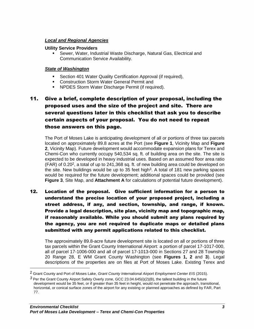
Local and Regional Agencies
Utility Service Providers ▪ Sewer, Water, Industrial Waste Discharge, Natural Gas, Electrical and
Communication Service Availability.
State of Washington
▪ Section 401 Water Quality Certification Approval (if required), ▪ Construction Storm Water General Permit and ▪ NPDES Storm Water Discharge Permit (if required).
11. Give a brief, complete description of your proposal, including the
proposed uses and the size of the project and site. There are
several questions later in this checklist that ask you to describe
certain aspects of your proposal. You do not need to repeat
those answers on this page.
The Port of Moses Lake is anticipating development of all or portions of three tax parcels located on approximately 89.8 acres at the Port (see Figure 1, Vicinity Map and Figure 2, Vicinity Map). Future development would accommodate expansion plans for Terex and Chemi-Con who currently occupy 540,534 sq. ft. of building area on the site. The site is expected to be developed in heavy industrial uses. Based on an assumed floor area ratio
(FAR) of 0.202, a total of up to 241,368 sq. ft. of new building area could be developed on the site. New buildings would be up to 35 feet high3. A total of 181 new parking spaces would be required for the future development; additional spaces could be provided (see Figure 3, Site Map, and Attachment A for calculations of potential future development).
12. Location of the proposal. Give sufficient information for a person to
understand the precise location of your proposed project, including a
street address, if any, and section, township, and range, if known.
Provide a legal description, site plan, vicinity map and topographic map,
if reasonably available. While you should submit any plans required by
the agency, you are not required to duplicate maps or detailed plans
submitted with any permit applications related to this checklist.
The approximately 89.8-acre future development site is located on all or portions of three tax parcels within the Grant County International Airport: a portion of parcel 17-1017-000, all of parcel 17-1006-000 and all of parcel 17-1013-000 in Sections 27 and 28 Township 20 Range 28, E WM Grant County Washington (see Figures 1, 2 and 3). Legal descriptions of the properties are on files at Port of Moses Lake. Existing Terex and
2 Grant County and Port of Moses Lake, Grant County International Airport Employment Center EIS (2015). 3 Per the Grant County Airport Safety Overly zone, GCC 23.04.645(i)(2)(B), the tallest building in the future
development would be 35 feet, or if greater than 35 feet in height, would not penetrate the approach, transitional, horizontal, or conical surface zones of the airport for any existing or planned approaches as defined by FAR, Part 77.
Environmental Checklist 4
Port of Moses Lake Development – Terex and Chemi-Con Properties
Chemi-Con buildings are present on the site. The street addresses of these buildings are: Terex (Genie) – 8987 Graham Street NE, Moses Lake, WA 98837, and Chemi-Con – 9053 Graham Street, Moses Lake, WA 98837. The topography of the site is relatively flat.
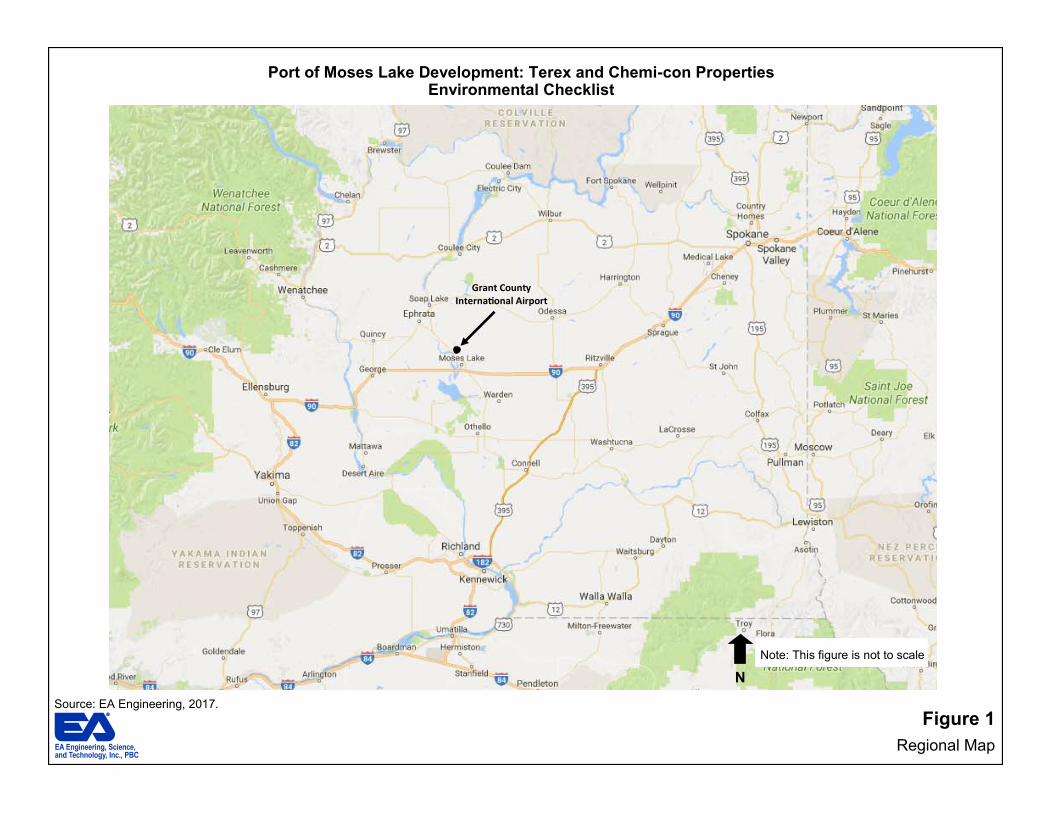
Source: EA Engineering, 2017.
Figure 1
Regional Map
Port of Moses Lake Development: Terex and Chemi-con Properties Environmental Checklist
Grant County International Airport
N
Note: This figure is not to scale

Source: EA Engineering, 2017. Figure 2
Vicinity Map
Port of Moses Lake Development: Terex and Chemi-con Properties Environmental Checklist
Terex & Chemi-con Project Site
GCIA EIS Site Boundary
Airport Boundary
N
Note: This figure is not to scale
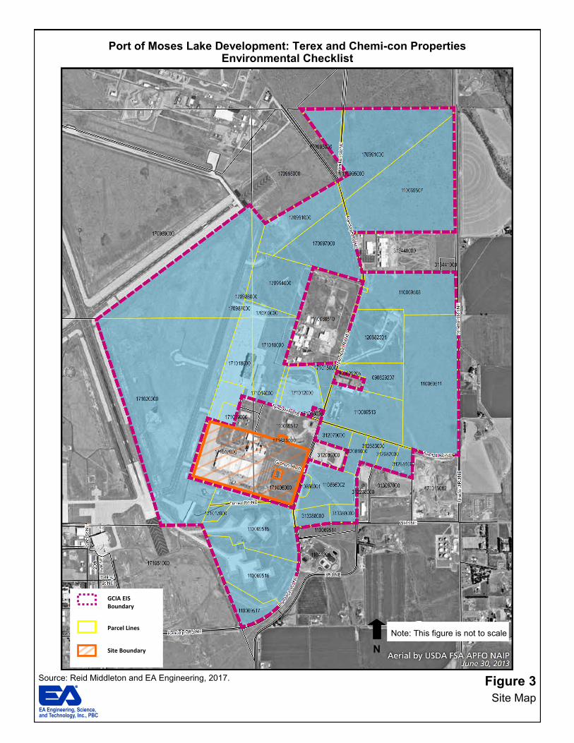
Source: Reid Middleton and EA Engineering, 2017. Figure 3
Site Map
Port of Moses Lake Development: Terex and Chemi-con Properties Environmental Checklist
GCIA EIS Boundary
Parcel Lines
Site Boundary
171013000
N
Note: This figure is not to scale
Environmental Checklist 8
Port of Moses Lake Development – Terex and Chemi-Con Properties
B. ENVIRONMENTAL ELEMENTS
1. Earth
A Geotechnical report was prepared by Landau Associates for the Grant County International Airport Employment Center EIS (2015). This report was consulted to respond to the SEPA Checklist questions related to earth.
a. General description of the site (circle one): Flat, rolling, hilly, steep slopes, mountainous, other (describe):
The project site is generally flat.
b. What is the steepest slope on the site (approximate percent slope)?
The steepest slope is approximately 2%.
c. What general types of soils are found on the site (for example, clay, sand, gravel, peat, muck)? If you know the classification of agricultural soils, specify them and note any prime farmland.
Soils onsite are dense, cobbly gravels with some sand and boulders. These soils have high compressive strength and are relatively free draining.4 No prime farmland is located onsite.
d. Are there surface indications or history of unstable soils in the immediate vicinity? If so, describe. The entire Pacific Northwest region, including the Moses Lake area in which the site is located, lies within a seismically active area, and moderate levels of ground shaking is anticipated in the future. The site is located approximately 16 miles north of the easternmost extent of the Frenchman Hills Fault (the closest mapped active earthquake fault). Any future ground rupture that may occur within the Frenchman Hills Fault will likely have no ground rupture impact on the site. The site is not mapped as a potential liquefaction hazard area, and the subsurface conditions indicate that liquefaction is not a significant risk at the site. New buildings and infrastructure would be designed in accordance with the most current version of the International Building Code (IBC) to address potential life safety impacts from seismic events.
4 Terex Aerial Work Platforms (Genie Industries) SEPA Checklist, KSI Architecture and
Planning, 2014.
Environmental Checklist 9
Port of Moses Lake Development – Terex and Chemi-Con Properties
e. Describe the purpose, type, and approximate quantities and total affected area of any filling or grading proposed. Indicate source of fill.
Grading and site disturbance would be required for future development of the properties. Minimal grading is expected for site development. Any fill require for development would be from an approved source.
f. Could erosion occur as a result of clearing, construction, or use? If so, generally describe. Site grading and construction associated with future development could cause erosion of exposed soil and soil stockpiles. Temporary erosion and sedimentation control (TESC) measures and best management practices (BMPs) would be implemented during construction of future site improvements. As a result, no significant erosion/sedimentation-related impacts are expected. Once the buildings are operational, no erosion is anticipated because soils would not be exposed.
g. About what percent of the site will be covered with impervious surfaces after project construction (for example, asphalt or buildings)?
Based on a 27.7 acres of net new developable area, at 91% impervious surface coverage, future development is expected to result in approximately 25.2 acres of new impervious surfaces, or 28% of the site.
h. Proposed measures to reduce or control erosion, or other impacts to the earth, if any:
The following mitigation measure would be implemented to reduce or control erosion and other earth impacts of the future development:
Comprehensive Drainage Control Plans (including Construction Best Management Practices and Erosion and Sediment Control Plans) would be submitted as part of Building Permit applications, in accordance with Grant County requirements.
2. Air
An Air Quality/Greenhouse Gas Emissions report was prepared by Landau Associates for the Grant County International Airport Employment Center EIS (2015). This report was consulted to respond to the SEPA Checklist questions related to air. Greenhouse Gas Emissions Worksheets were prepared for the Port of Moses Lake Development: Terex and Chemi-Con Properties by EA in October 2017 (see Appendix B). The results are summarized below.
Environmental Checklist 10
Port of Moses Lake Development – Terex and Chemi-Con Properties
a. What type of emissions to the air would result from the proposal (i.e., dust, automobile, odors, industrial wood smoke) during construction and when the project is completed? If any, generally describe and give approximate quantities if known.
The future development could result in localized increases in air emissions (primarily carbon monoxide and dust) due to construction vehicles, equipment and activities. To evaluate the climate change impacts of the future development, Greenhouse Gas Emissions Worksheets were prepared to estimate the emissions footprint for the lifecycle of the projects on a gross-level basis. The emissions estimates use the combined emissions from the following sources:
▪ Embodied Emissions – extraction, processing, transportation, construction and disposal of materials and landscape disturbance;
▪ Energy-Related Emissions – energy demands created by the development after it is completed; and
▪ Transportation-Related Emissions – transportation demands created by the development after it is completed.
The Worksheet estimates are based on building use and size. The estimated lifespan emissions of future potential development would total approximately 379,956 metric tons of CO2 equivalent (MTCO2e) (see Appendix B to this Checklist for the Greenhouse Gas Emissions Worksheets)5. Based on an average building lifespan of approximately 62.5 years, it is anticipated that annual emissions from the project would be approximately 6,079 MTCO2e. The scale of global climate change is so large that a single project’s impacts can only be evaluated on a cumulative scale. A single project, even one the scale of the proposed project, would not cause an individually discernable impact on global climate change. Future development would be designed to conform to applicable regulations and standards of agencies regulating air quality in Grant County, including: the Environmental Protection Agency (EPA) and Washington State Department of Ecology (DOE).
b. Are there any off-site sources of emissions or odor that may
affect your proposal? If so, generally describe. There are no off-site sources of air emissions or odors that may affect future development of the site.
5
For the purposes of the GHG Emissions Worksheet calculations, the proposed building use
for the project is categorized as “Other” which includes buildings whose primary activity is
industrial or manufacturing.
Environmental Checklist 11
Port of Moses Lake Development – Terex and Chemi-Con Properties
c. Proposed measures to reduce or control emissions or other impacts to air, if any:
The following mitigation measures could be implemented to control emissions and/or dust during construction of the future development:
Well-maintained equipment could be used to reduce emissions from construction equipment and construction-related trucks, as would avoiding prolonged periods of vehicle idling.
Electrically operated small tools could be used in place of gas
powered small tools, wherever feasible. Building materials trucked to and from the project site could be
scheduled and coordinated to minimize congestion during peak travel times associated with adjacent roadways.
3. Water
A Critical Areas/Plants and Animals report was prepared by GeoEngineers for the Grant County International Airport Employment Center EIS (2015). This report was consulted to respond to the SEPA Checklist questions related to water.
a. Surface:
1) Is there any surface water body on or in the immediate vicinity of the site (including year-round and seasonal streams, saltwater, lakes, ponds, wetlands)? If yes, describe type and provide names. If appropriate, state what stream or river it flows into.
There are no surface water bodies on the site. The closest water bodies include Crab Creek, approximately 1.5 miles to the east and Moses Lake approximately 3.5 miles to the southwest of the site.
2) Will the project require any work over, in, or adjacent to
(within 200 feet) the described waters? If yes, please describe and attach available plans. Future development would not require work over, in or adjacent to (within 200 feet) of Crab Creek or Moses Lake.
3) Estimate the amount of fill and dredge material that would be placed in or removed from surface water or wetlands and indicate the area of the site that would be affected. Indicate the source of fill material.
No fill or dredge material would be placed in or removed from any surface water body or wetlands with future development.

Environmental Checklist 12
Port of Moses Lake Development – Terex and Chemi-Con Properties
4) Will the proposal require surface water withdrawals or diversions? Give general description, purpose, and approximate quantities if known.
No. Future development would not require any surface water withdrawals or diversions.
5) Does the proposal lie within a 100-year floodplain? If so, note location on the site plan.
No, the project site does not lie within a 100-year floodplain.
6) Does the proposal involve any discharges of waste materials to surface waters? If so, describe the type of waste and anticipated volume of discharge.
No. There would be no discharge of waste materials to surface waters.
b. Ground:
1) Will ground water be withdrawn, or will water be discharged to ground water? Give general description, purpose, and approximate quantities if known.
No ground water would be withdrawn or water discharged to ground water.
2) Describe waste material that will be discharged into the ground from septic tanks or other sources, if any (for example: domestic sewage; industrial, containing the following chemicals…; agricultural; etc.). Describe the general size of the system, the number of such systems, the number of houses to be served (if applicable), or the number of animals or humans the system(s) are expected to serve.
Waste material would not be discharged into the ground from septic tanks or other sources. Sewer service for future development would be provided by City of Moses Lake. Industrial waste water service would be provided by Port of Moses Lake.
Environmental Checklist 13
Port of Moses Lake Development – Terex and Chemi-Con Properties
c. Water Runoff (including storm water):
1) Describe the source of runoff (including storm water) and method of collection and disposal, if any (include quantities, if known). Where will this water flow? Will this water flow into other waters? If so, describe.
New impervious surfaces constructed on the site would be the source of storm water runoff from future development. Future development is expected to introduce approximately 25.2 acres of new impervious surfaces. Temporary and permanent storm water control systems would be provided to properly collect and dispose of storm water. There are no surface waters on or near the site to which storm water would flow.
2) Could waste materials enter ground or surface waters? If so, generally describe.
No. The proposed temporary and permanent storm water control systems and associated mitigation measures would prevent waste materials from entering ground water or surface waters.
d. Proposed measures to reduce or control surface, ground, and runoff water impacts, if any:
The following mitigation measures would be implemented to reduce or control surface, ground and runoff water impacts from the future development:
Storm water discharge during construction would be subject to a General National Pollutant Discharge Elimination System (NPDES) permit issued by Washington State Department of Ecology (Ecology). Temporary erosion and sedimentation control and Best Management Practices (BMPs) would be implemented to control storm water runoff during construction, consistent with the Ecology Storm Water Management Manual for Eastern Washington.
The permanent storm water control system(s) for future
development at the site would also be developed and constructed in accordance with the Ecology Storm Water Management Manual for Eastern Washington. Per the Manual, storm water would be retained within the site and water quality treatment would be provided for runoff from pollution-generating surfaces (e.g., roads and parking areas).

Environmental Checklist 14
Port of Moses Lake Development – Terex and Chemi-Con Properties
4. Plants
A Critical Areas/Plants and Animals report was prepared by GeoEngineers for the Grant County International Airport Employment Center EIS (2015). This report was consulted to respond to the SEPA Checklist questions related to plants.
a. Check or circle types of vegetation found on the site:
__deciduous tree: alder, maple, pine, other _ evergreen tree: fir, cedar, pine, other X shrubs X_grass __ pasture __ crop or grain __ wet soil plants: cattail, buttercup, bulrush, skunk cabbage, other __ water plants: water lily, eelgrass, milfoil, other _ other types of vegetation:
b. What kind and amount of vegetation will be removed or altered?
Vegetation on the undeveloped portions of the site, consisting of a mix of sagebrush vegetation communities and grasses, would be removed for future development. Future development is expected to introduce approximately 25.2 acres of new impervious surfaces.
c. List threatened or endangered species known to be on or near the site.
Based on a past study of the site area6, the following federal and/or state-listed plant species could be present in the shrub steppe and open grassland habitat on or near the site:
▪ Great Basin gilia (Aliciella leptomeria) – state threatened species
▪ Wormskiold’s northern wormwood (Artemisia campestris var. wormskioldii) – state endangered, federal candidate species
▪ Palouse milk-vetch (Astragalus arrectus) – state threatened species
▪ Nuttall’s sandwort (Minuartia nuttallii var. fragilis) – state threatened species
▪ Wanapum crazyweed (Oxytropis campestris var. wanapum) – state endangered species, federal species of concern
d. Proposed landscaping, use of native plants, or other measures to preserve or enhance vegetation on the site, if any:
The following mitigation measures would be implemented to preserve or enhance vegetation on the site with future development:
6 Grant County International Airport Employment Center EIS Plant and Animal Assessment,
GeoEngineers, 2015.
Environmental Checklist 15
Port of Moses Lake Development – Terex and Chemi-Con Properties
Landscaping would be provided with the future development that would meet Grant County’s requirements.
Native plants and drought-tolerant plant species could be incorporated into the landscaping of the future development, if practical.
If impacts to priority plant species are unavoidable, appropriate mitigation measures would be implemented, as needed.
5. Animals
A Critical Areas/Plants and Animals report was prepared by GeoEngineers for the Grant County International Airport Employment Center EIS (2015). This report was consulted to respond to the SEPA Checklist questions related to animals.
a. Circle (underlined) any birds and animals that have been observed on or near the site or are known to be on or near the site:
birds: hawk, heron, eagle, songbirds, other: mammals: deer, bear, elk, beaver, other: small mammals. fish: bass, salmon, trout, herring, shellfish.
Resident and migratory birds are common to the area. Medium size and small mammals that may be present on and near the site include rodents, shrews and coyotes. Reptiles (lizards and snakes) are also likely occur in the area. Amphibians would not likely be present as there are no aquatic features.
b. List any threatened or endangered species known to be on or near the site.
Based on a past study of the site area7, the following federal and/or state-listed species could occur in the shrub steppe habitat on and near the site:
▪ Burrowing Owl (Athene cunicularia) – state candidate species ▪ Greater sage grouse (Centrocercus urophasianus) – state
threatened, federal candidate species ▪ Long-billed curlew (Numenius americanus) – state priority
habitat species ▪ Washington ground squirrel (Urocitellus washingtoni) ▪ Loggerhead shrike (Lanius ludovicianus) – state candidate
species ▪ Merriam’s shrew (Sorex merriami) – state candidate species ▪ Preble’s shrew (Sorex preblei) – state candidate species
7 Grant County International Airport Employment Center EIS Plant and Animal Assessment,
GeoEngineers, 2015.
Environmental Checklist 16
Port of Moses Lake Development – Terex and Chemi-Con Properties
▪ Black-tailed Jackrabbit (Lepus californicus) – state candidate species
▪ White-tailed jackrabbit (Lepus townsendii) – state candidate species
c. Is the site part of a migration route? If so, explain.
The Pacific Flyway is a major north-south flyway for migratory birds in America—extending from Alaska to Patagonia. Every year, migratory birds travel some or all this distance both in spring and in fall, following food sources, heading to breeding grounds or travelling to overwintering sites. Most of Washington state, including the site area, is within this flyway.
d. Proposed measures to preserve or enhance wildlife, if any:
The following mitigation measures would be implemented to preserve or enhance wildlife with future development: .
Future development would be subject to Grant County regulations at the time of permit issuance.
TESC and BMPs would be implemented to control storm water runoff during construction to prevent erosion, sedimentation and pollutant impacts on off-site water resources and associated impacts on aquatic habitat and species.
Burrowing owl nesting surveys could be conducted to determine the potential presence of these species within the specific site area at the time of development applications.
If active burrowing owl nests are found, work would be restricted within 0.5 mile of the nests.
If impacts to priority wildlife species are unavoidable,
appropriate mitigation measures would be implemented as needed.
A permanent storm water control system would be installed to
prevent long-term erosion, sedimentation and pollutant impacts on off-site water resources and associated impacts on off-site aquatic habitat and species.
6. Energy and Natural Resources
a. What kinds of energy (electric, natural gas, oil, wood stove, solar) will be used to meet the completed project’s energy needs? Describe whether it will be used for heating, manufacturing, etc.
Electricity and natural gas are the primary sources of energy that would serve the future development. During operation, these energy sources
Environmental Checklist 17
Port of Moses Lake Development – Terex and Chemi-Con Properties
would be used for project heating, cooling, hot water, lighting and manufacturing.
b. Would your project affect the potential use of solar energy by adjacent properties? If so, generally describe.
No. Future development would not affect adjacent properties’ use of solar energy.
c. What kinds of energy conservation features are included in the plans of this proposal? List other proposed measures to reduce or control energy impacts, if any:
The following mitigation measure could be implemented to provide energy conservation with future development:
Where feasible, building systems could include high efficiency mechanical systems, rain water harvesting, solar hot water, photovoltaics, storm water control through green roofs and/or landscape features.
7. Environmental Health
A review of ongoing remediation and cleanup overseen by the U.S. EPA in the site area was performed for the Grant County International Airport Employment Center EIS (2015). This review, as well as EPA’s website, was consulted to respond to the SEPA Checklist questions related to environmental health hazards.
a. Are there any environmental health hazards, including exposure to toxic chemicals, risk of fire and explosion, spill, or hazardous waste that could occur as a result of this proposal? If so, describe.
Exposure to hazardous site materials (soil and ground water) could occur with the future development, as described below. The Moses Lake Wellfield Contamination Superfund Site includes parts of the former Larson Air Force Base (AFB), Grant County International Airport and some areas south of the airport. The future development site is located within the Superfund Site. Several soil and ground water areas at the Superfund site are contaminated with trichloroethylene (TCE) and other hazardous chemicals from the old base and aircraft industrial activities. U.S. EPA assumed the role of lead agency for cleanup/remediation of the Superfund Site. Studies by EPA found two ground water plumes contaminated with TCE that begin under the former Larson Air Force Base and spread to the south. The future development site is located within the Northeast Plume. Twelve soil sites on the former base and around the airport were used as dumps
Environmental Checklist 18
Port of Moses Lake Development – Terex and Chemi-Con Properties
and landfills. EPA is starting the investigation and cleanup at two of the soil sites that pose the biggest environmental risk: Sites 20 and 22. Three of the locations of possible soil contamination are on or near the future development site: Sites 14, 15 and 18. The ten other sites, including Sites 14, 15 and 18, are in the process of being evaluated to determine the order of cleanup. Hydraulic oil and fuel would be used and could be stored onsite during construction of the future project. Toxic substances could be produced during operation of the future development. If handled improperly, oil and fuel spills during construction and toxic substance spills and contact during operation could occur.
1) Describe special emergency services that might be required.
No special emergency services are anticipated to be required for the future development. As is typical of heavy industrial development, it is possible that normal fire, medical and other emergency services may, on occasion, be needed from the Grant County Sheriff’s Office and Grant County Fire District #5.
2) Proposed measures to reduce or control environmental health hazards, if any:
The following mitigation measures would be implemented to reduce or control environmental health hazards with future development:
Prior to and During Construction Soil Management – Compliance with the soil management
provisions of institutional controls developed by EPA would be ensured, and compliance of all future site construction activities with these control measures would be ensured as well.
Worker Health & Safety – Compliance with construction
worker safety protocols defined as part of institutional controls would be ensured, and compliance of all future site construction activities with these control measures would be ensured as well.
Storm Water Quality Impacts – Cover soil would be
maintained over contaminated soils where practicable, and/or storm water treatment and monitoring during construction activities that could disturb contaminated soils would be implemented.
Ground Water Quality – Compliance with the institutional
controls during site cleanup and development construction activities would be ensured.
Environmental Checklist 19
Port of Moses Lake Development – Terex and Chemi-Con Properties
Facility/Land Use Siting – A review of use restrictions associated with institutional control plans would be incorporated as part of future building permit reviews, and either: 1) would ensure that all future uses comply with these use restrictions or 2) would require conducting additional removals of the contained hazardous materials in coordination with local, state and federal agencies, as necessary, to remove the use restrictions.
Discovery of New Cleanup Issues – Compliance with release
reporting, investigation and applicable cleanup provisions of the applicable regulations would be ensured.
During Operation
Soil Management and Worker Safety – Utility corridors would initially be developed with clean backfill material where practicable. Where this is not practicable, the same soil management and worker safety provisions applicable to construction activities (e.g., compliance with worker training, monitoring and work practice requirements defined in site institutional control plans) would apply to utility maintenance or other subsurface maintenance activities.
Future Hazardous Materials Use – The use, storage and/or processing of any hazardous materials would comply with local (e.g., fire department hazardous materials regulations), state (e.g., Washington underground storage tank regulations) and federal regulations (e.g., federal spill prevention control and counter-measures requirements) relating to the use, storage or processing of hazardous materials.
b. Noise
A Noise report was prepared by Landau Associates for the Grant County International Airport Employment Center EIS (2015). The report was consulted to respond to the SEPA Checklist questions related to noise.
1) What types of noise exist in the area that may affect your project (for example: traffic, equipment operation, other)?
Currently, the site consists of industrial uses adjacent to the Grant County International Airport. The Airport has historically produced noise associated with jet takeoff, landing and taxiing, as well as maintenance operations. Traffic noise is currently present on nearby roads, including Randolph Road NE, Graham Road NE and Turner Road NE. The noise from these uses is not expected to adversely affect the future development.
Environmental Checklist 20
Port of Moses Lake Development – Terex and Chemi-Con Properties
2) What types and levels of noise would be created by or associated with the project on a short-term or a long-term basis (for example: traffic, construction, operation, other)? Indicate what hours noise would come from the site. Construction activities for the future development would generate noise. Typical construction activities would include clearing, grading and building and infrastructure construction and would employ equipment such as dump trucks, excavators, pavers, generators and compressors. Construction noise would be short-term and would typically occur during daytime hours. Grant County does not regulate noise from temporary construction. The site would be developed in heavy industrial uses that could produce noise from industrial operations. The assumed uses are allowed by the site’s Airport Master Plan designation and there are no noise-sensitive receivers in the immediate site vicinity. It is assumed that future development would comply with the applicable noise regulations which establish permissible noise levels from industrial noise sources at receiving residential properties. As such, the industrial activities with future development are not anticipated to result in significant noise impacts. Future development would generate noise from vehicular traffic. The transportation analysis prepared for this SEPA Checklist calculated that employees from the future development would generate about 210 trips during the AM peak hour and 190 trips during the PM peak hour (see Appendix C for details). The noise from these trips is not expected to result in significant impacts and the County does not regulate noise from traffic.
3) Proposed measures to reduce or control noise impacts, if any:
The following mitigation measures would be implemented to reduce or control noise impacts from the future development:
Future industrial operations would comply with applicable noise regulations which establish permissible noise levels from industrial noise sources at receiving off-site properties.
8. Land and Shoreline Use
a. What is the current use of the site and adjacent properties? Two heavy industrial facilities currently occupy the site. The Terex (Genie) facility, located in the southern portion of parcels 17-1017-000 and 17-1006-000, is used for the manufacturing of aerial lifts. The Chemi-Con facility, located in the northern portion of parcels 17-1017-000 and 17-1006-000, is used for the manufacturing of aluminum electrode foil.

Environmental Checklist 21
Port of Moses Lake Development – Terex and Chemi-Con Properties
Land uses surrounding the site include:
▪ North – facilities and aprons operated by the Boeing Company, vacant parcels zoned for Heavy Industrial use in the County and vacant parcels designated for Revenue Support/Aviation Development in the Grant County International Airport Master Plan;
▪ East – Randolph Road NE and vacant parcels zoned for heavy industrial use in the City of Moses Lake;
▪ South – Turner Road NE and the Airport Alert Hangar apron and the “Christmas Tree” aprons at the Grant County International Airport; and
▪ West – The east area aprons and taxiways and runways at Grant County International Airport.
b. Has the site been used for agriculture? If so, describe
No, the site has not been used as working farmlands for over 100 years.
b. Describe any structures on the site.
Two facilities currently occupy the site, as described below. Terex (Genie) Facilities (located on Parcels 17-1017-000 and 171-006-000)
▪ Building 5820 – approximately 422,334 sq. ft. (Port-owned), used for manufacturing of aerial lift platforms
▪ PDI Building – approximately 8,400 sq. ft. (constructed by Genie), used for pre-delivery inspection of aerial lifts
▪ Shipping Dock – approximately 4,400 sq. ft. (constructed by Genie), used for shipping and receiving of stock and inventory
Chemi-Con Materials Corporation Facilities (located on Parcels 17-1017-000 and 17-1006-000)
▪ Building 5825 – approximately 81,280 sq. ft. (Port-owned), used for manufacturing of aluminum electrode foil
▪ Environmental Building – approximately 31,000 sq. ft. (Port-owned), used for manufacturing of aluminum electrode foil
There is a total of 540,534 sq. ft. of existing buildings on the site.
d. Will any structures be demolished? If so, what?
No structures would be demolished for the future development.
e. What is the current zoning classification of the site?
The site is currently zoned “Grant County International Airport” in the Grant County Unified Development Code. Land uses within these areas
Environmental Checklist 22
Port of Moses Lake Development – Terex and Chemi-Con Properties
are regulated by the Grant County International Airport Master Plan. The Master Plan designates the site as Revenue Support or Aviation Development. The Revenue Support classification includes all potential development that is compatible with airport activities but is unlikely to require access to the runway and taxiway system. This classification may include both aviation and non-aviation development. Research facilities, testing laboratories, and facilities for the manufacturing, processing and/or assembly of products and warehouses are some of the land uses that may be included in Revenue Support areas. Aviation Development area is defined as those areas that must be reserved for development that needs access to Airfield Operations area. In general, current and future aircraft access must be preserved to these areas.
f. What is the current comprehensive plan designation of the site?
The site is designated “Port of Moses Lake” in the Grant County Comprehensive Plan. Land uses within these areas are governed by the Grant County International Airport Master Plan. See the discussion of the Master Plan above.
g. If applicable, what is the current shoreline master program designation of the site? The site is not located in a shoreline master program designation.
h. Has any part of the site been classified as an “environmentally sensitive” area? If so, specify.
The entire Pacific Northwest region, including the site, is located within a seismic hazard area. New buildings and infrastructure would be designed in accordance with the most current version of the International Building Code (IBC) to address potential life safety impacts from seismic events. Grant County, including the site, is considered a critical aquifer recharge area. The permanent storm water control system(s) for future development at the site would be developed and constructed in accordance with the Ecology Storm Water Management Manual for Eastern Washington and would protect the critical aquifer recharge area.
i. Approximately how many people would reside or work in the completed project?
The project would not contain any residential units; therefore, no people would reside in the future development. The future development could provide a total of approximately 525 jobs.

Environmental Checklist 23
Port of Moses Lake Development – Terex and Chemi-Con Properties
j. Approximately how many people would the completed project displace? The completed development project would not displace any people.
k. Proposed measures to avoid or reduce displacement impacts, if any:
No displacement impacts would occur and no mitigation measures are necessary.
l. Proposed measures to ensure the proposal is compatible with existing and projected land uses and plans, if any:
The project is compatible with existing and projected land uses and plans, and no mitigation is necessary.
9. Housing
a. Approximately how many units would be provided, if any? Indicate whether high, middle, or low-income housing.
No housing units would be provided.
b. Approximately how many units, if any, would be eliminated? Indicate whether high, middle, or low-income housing.
No housing presently exists onsite and none would be eliminated.
c. Proposed measures to reduce or control housing impacts, if any:
No housing impacts would occur and no mitigation measures would be necessary.
10. Aesthetics
a. What is the tallest height of any proposed structure(s), not including antennas; what is the principal exterior building material(s) proposed?
Per the Grant County Airport Safety Overly zone, GCC 23.04.645(i)(2)(B), the tallest building in the future development would be 35 feet, or if greater than 35 feet in height, would not penetrate the approach, transitional, horizontal or conical surface zones of the airport for any existing or planned approaches as defined by FAR, Part 77. The shell of the building could be engineered steel and/or concrete tilt up.

Environmental Checklist 24
Port of Moses Lake Development – Terex and Chemi-Con Properties
b. What views in the immediate vicinity would be altered or obstructed?
No views in the immediate vicinity would be altered or obstructed by the future development.
c. Proposed measures to reduce or control aesthetic impacts, if any: No significant aesthetic/views impacts are anticipated with the future development and no mitigation measures are required.
11. Light and Glare
a. What type of light or glare will the proposal produce? What time of day would it mainly occur?
At times during the construction process, area lighting of the job sites (to meet safety requirements) may be necessary, which would be noticeable proximate to the site. However, light and glare from construction of the future development is not anticipated to adversely affect adjacent land uses. Once operational, interior and exterior building lighting and parking lot lighting could at times be visible from adjacent land uses and streets. The amount of light and associated glare is not expected to differ substantially from that which presently occurs from other buildings/structures of similar height on and near the site. Stationary sources of light would include interior lighting, building and parking entrance lighting; pedestrian-level façade lighting; and security lighting. Sources of glare would include any mirrored and/or glazed building facade materials.
b. Could light or glare from the finished project be a safety hazard or interfere with views?
No light or glare safety hazards or view interference are anticipated.
c. What existing off-site sources of light or glare may affect your proposal? No off-site sources of light or glare are anticipated to affect the future development.
d. Proposed measures to reduce or control light and glare impacts, if any: No significant long-term light or glare-related impacts are anticipated with the future development and no mitigation measures are necessary.

Environmental Checklist 25
Port of Moses Lake Development – Terex and Chemi-Con Properties
However, the following mitigation measures could be implemented to help reduce overall light and glare from future development:
Excessively-reflective surfaces (i.e., mirrored glass or polished metals) that go beyond what is required to meet energy-related code provisions could be minimized on the exterior of the project buildings.
Pedestrian-scale lighting would be provided consistent with
code, function and safety requirements. Exterior lighting could include fixtures to direct the light downward and/or upward and away from off-site land uses.
New exterior lighting could be provided by light fixtures with well
shielded sources that have precise optical control to reduce impacts to neighboring properties.
12. Recreation
a. What designated and informal recreational opportunities are in the immediate vicinity?
There are no designated or informal recreational opportunities in the immediate vicinity of the site. The closest recreational facilities to the site are at Big Bend Community College and the closest park is Connelly Park on Moses Lake, approximately one mile and three miles to the southwest of the site, respectively.
b. Would the proposed project displace any existing recreational uses? If so, describe.
The project would not displace any existing recreational uses.
c. Proposed measures to reduce or control impacts on recreation, including recreation opportunities to be provided by the project or applicant, if any: No significant recreation impacts are anticipated and no mitigation measures are necessary.
13. Historic and Cultural Preservation
A Historic and Cultural Resources report was prepared by Cultural Resource Consultants (CRC) for the Grant County International Airport Employment Center EIS (2015). The report was consulted to respond to the SEPA Checklist questions related to historic and cultural preservation.
Environmental Checklist 26
Port of Moses Lake Development – Terex and Chemi-Con Properties
a. Are there any places or objects listed on, or proposed for, national, state, or local preservation registers known to be on or next to the site? If so, generally describe.
There are no known places or objects listed on, or proposed for, any preservation registers on or next to the site.
b. Generally describe any landmarks or evidence of historic, archaeological, scientific or cultural importance know to be on or next to the site. Ethnographic Context The site lies within the traditional territory of the Sinkayuse or Moses Columbia Tribes, which are Middle Columbia River Salishan people recognized as constituent tribes of, and today represented by, the Confederated Tribes of the Colville Reservation. Cultural Sites
Relatively few archaeological or historic sites have been identified in proximity to the site. The nearest archaeological sites are located one to two miles away. These include seven historic period archaeological sites and one precontact isolate. The nearest precontact archaological sites are over two miles west and southwest of the site near the present-day Moses Lake shoreline. These include a low-density scatter of precontact lithic material and two precontact house pit sites on the Moses Lake shoreline over two miles southwest of the site.
Register-Listed Properties There are no register-listed historic properties within a ten-mile radius of the project site. The nearest register-listed sites are the Bell Hotel and Grant County Courthouse in Ephrata approximately 13 miles to the northwest, and the Lind Coulee Archaeological Site approximately 20 miles to the southeast, outside the town of Warden. Several historic buildings have been inventoried within a quarter mile of the site. These include former Larson AFB facilities such as single-family homes built as military housing, drainage ditches and other infrastructure, a railroad branch line and a hangar. Most of them were determined not eligible for the National Register of Historic Places (NRHP). The Larson AFB In-Flight Kitchen was determined eligible for the NRHP.
One recorded historic structure is located near the project site. The structure is a drainage ditch in an undeveloped field adjacent to the Alert Center, approximately 2,000 feet to the southwest of the site, which was used either for storm drainage or to drain water used in extinguishing fires that might occur on the base. The ditch was determined not eligible for the NRHP.
Environmental Checklist 27
Port of Moses Lake Development – Terex and Chemi-Con Properties
Potential for Previously Unrecorded Historic and Cultural Resources The Washington State Department of Archeology and Historic Preservation (DAHP) statewide predictive model uses environmental data about the locations of known archaeological sites to identify where previously unknown archaeological sites are more likely to be found. Although the model suggests high archaeological potential for the site area, information derived from historical maps, photographs, geological maps and other sources indicate that overall, the landscape of the site area has a low potential to contain archaeological sites.
c. Proposed measures to reduce or control impacts, if any.
The following mitigation measures would be implemented to avoid, minimize, or compensate for loss, changes to, and disturbance of historic and cultural resources from the future development:
Should any potentially significant archaeological or historic sites be encountered during future development that could not be avoided, impacts could potentially be minimized by measures including:
▪ Limiting the magnitude of the proposed work;
▪ Modifying development through redesign or reorientation to minimize or avoid further impacts to resources;
▪ Rehabilitation, restoration or repair of affected resources;
▪ Preserving and maintaining operations for any involved significant historic structures;
▪ Archaeological monitoring, testing or data recovery excavations; and/or
▪ Documentation of historic elements of the built environment through photographs, drawings and narrative, at the appropriate level based upon DAHP standards.
In the event that ground-disturbing or other activities result in
the inadvertent discovery of archaeological deposits, work would be halted in the immediate area and contact made with the DAHP. Work would be halted until such time as further investigation and appropriate consultation is concluded.
In the unlikely event of the inadvertent discovery of human
remains, work would be immediately halted in the area, the discovery covered and secured against further disturbance, and contact made with law enforcement personnel, consistent with the provisions set forth in RCW 27.44.055 and RCW 68.60.055.

Environmental Checklist 28
Port of Moses Lake Development – Terex and Chemi-Con Properties
14. Transportation
A Transportation Analysis was prepared for the Port of Moses Lake Development: Terex and Chemi-Con Properties by Heffron Transportation in November 2017 (see Appendix C). The following responses summarize the findings in this report.
a. Identify public streets and highways serving the site and describe the proposed access to the existing street system. Show on site plans, if any.
To the north of the site is Tyndall Road NE, to the east is Randolph Road NE and to the south is Turner Road NE. Graham Street extends into the central portion of the site (see Figure 3).
b. Is site currently served by public transit? If not, what is the approximate distance to the existing street system, show on site plans, if any?
Transit service in the general area is provided by Grant Transit Authority. There is no direct transit service to the site areas, although several routes serve the Big Bend Community College approximately one mile southwest of the site. Routes that serve the general area include:
▪ Route 50: Big Bend – Cascade Valley – Aquatic Center ▪ Route 54: Moses Lake – Soap Lake – Ephrata – Quincy
(weekend service only) ▪ Route 56: Moses Lake – Warden ▪ Route 58: Ephrata – Royal City – Moses Lake ▪ Route 59: Moses Lake – Ephrata – Soap Lake – Grand Coulee ▪ Route 62: Ephrata – Moses Lake (Big Bend Community
College)
▪ Route 65: Big Bend Community College – Ephrata – Soap Lake
c. How many parking spaces would the completed project have? How many would the project or proposal eliminate?
Parking is currently provided for the existing buildings onsite. It is not expected that any of this parking would be eliminated with future development. A total of 181 parking spaces would be needed for the future development, based on 0.75 spaces per 1,000 sq. ft. of building area for the 241,368 sq. ft. of potential new building area. Additional spaces, beyond the needed 181 spaces, could be provided.
d. Will the proposal require any new roads or streets, or improvements to existing roads or streets, not including driveways? If so, generally describe (indicate whether public or private).

Environmental Checklist 29
Port of Moses Lake Development – Terex and Chemi-Con Properties
Consistent with the GCIA Employment Center EIS (2015), traffic operations at the following four intersections were analyzed:
▪ Randolph Road NE/SR 17; ▪ Randolph Road NE/Patton Boulevard NE; ▪ Tyndall Road NE/Stratford Road NE (Road J NE); and ▪ Road 7 NE/Stratford Road NE (Road J NE).
The traffic from the future development would not trigger the need for any immediate traffic improvements. However, traffic from the future development together with traffic from the GCIA Employment Center studied in the 2015 EIS would ultimately require traffic improvements. Table 2 in Appendix B lists the intersection needs at various levels of development. The first improvements would likely be needed when about 4,750 employees occupy the future development of the three parcels and GCIA Employment Center (the future development would generate about 525 employees). The future development is not expected to result in any new impacts or require any additional improvements beyond those listed in the 2015 EIS.
(See Appendix B for details.)
e. Will the project or proposal use (or occur in the immediate vicinity of) water, rail, or air transportation? If so, generally describe.
There is no water transportation in the immediate site vicinity. The Columbia Basin Railroad Company operates rail lines in the City of Moses Lake and Grant County; however, the eastern side of the Grant County International Airport is not currently served by rail. The Northern Columbia Basin Railroad Project will restore rail service to the Port of Moses Lake/Grant County International Airport and provide new rail service to industrial-zoned lands adjacent to the Airport and along the Wheeler Industrial Corridor in Moses Lake. The project consists of three rail segments that will be owned by the Port and operated by the Columbia Basin Railroad Company. Construction of the project is expected to occur between 2019 and 2021 (pending final funding). Grant County International Airport is located to the west of the site. The Airport is a general aviation facility, as defined by the Federal Aviation Administration (FAA), which is intended to serve the aviation needs of the community. The Port of Moses Lake owns and operates the airport. The airport provides support to commercial, military and private aircraft.
f. How many vehicular trips per day would be generated by the completed project? If known, indicate when peak volumes would occur.
Future development is estimated to accommodate approximately 525 employees. These employees would generate about 1,100 vehicle trips per day; 210 trips during the AM peak hour and 190 trips during the PM

Environmental Checklist 30
Port of Moses Lake Development – Terex and Chemi-Con Properties
peak hour8. This represents an increase of about 3% compared to the trips evaluated in the GCIA Employment Center EIS.
g. Proposed measures to reduce or control transportation impacts, if any.
The following mitigation measures would be implemented to reduce or control transportation impacts from the future development:
An implementation and funding plan for the phased
transportation mitigation package could be prepared. Intersections would be improved per the threshold guidance
listed in Table 2 in Appendix B. The potential North Access Road could be deferred until cumulative development in the area reaches approximately 9,500 employees.
When transit demand warrants are met, the Port, City and
County would work with Grant Transit Authority to extend existing routes from Big Bend Community College to the site, or to establish new routes.
Pedestrian facilities would be constructed on at least one side
of new roads developed for the future development. The optimal location for new crosswalks at intersections would be assessed during the design of those improvements.
15. Public Services
a. Would the project result in an increased need for public services (for example: fire protection, police protection, health care, schools, other)? If so, generally describe.
No. The project would not result in an increased need for public services.
b. Proposed measures to reduce or control direct impacts on public services, if any.
While the potential increase in employees associated with the proposed projects could result in incrementally greater demand for emergency services, it is anticipated that adequate service capacity is available within the Port of Moses Lake area to preclude the need for additional public facilities/services.
8 Trip generation was determined using rates for Manufacturing use from the Institute of
Transportation Engineers (ITE), Trip Generation, 9th Edition (2010).
Environmental Checklist 31
Port of Moses Lake Development – Terex and Chemi-Con Properties
16. Utilities
A Project Data and Utilities Analysis was prepared for the Port of Moses Lake Development: Terex and Chemi-Con Properties by Reid Middleton in November 2017 (see Appendix A). The following responses summarize the findings related to utilities in this report.
a. Circle utilities currently available at the site: electricity, natural
gas, water, refuse service, telephone, sanitary sewer, septic system, other: industrial wastewater.
b. Describe the utilities that are proposed for the project, the utility providing the service, and the general construction activities on the site or in immediate vicinity that might be needed. Utilities and providers for the future development would include the following:
▪ Water – City of Moses Lake ▪ Sewer – City of Moses Lake ▪ Industrial Wastewater – Port of Moses Lake ▪ Natural Gas – Cascade Natural Gas Corporation ▪ Electricity – Grant County Public Utility District (PUD) ▪ Communications (Telephone and Internet) – Grant County
PUD and Century Link
Water The future development is estimated to require 106.3 acre-feet of water per year. The water demand from the future development alone would not trigger the need for any immediate water system improvements (the system can serve between 3 to 5 million sq. ft. of development before improvements are required; a total of up to 241,368 sq. ft. of new building area could be developed on the site). However, demand from the future development together with demand from the GCIA Employment Center development studied in the 2015 EIS would ultimately require water system improvements (e.g., drilling additional wells in the Larson zone. Note: in 2017, the Port completed its Utility Extension Project which constructed a fireline from the Port’s existing pumphouse/reservoir to the east side of the airport. This fireline provides fire suppression services to Terex and Chemi-Con and will serve any new facilities constructed in this area). Sanitary Sewer The future development is projected to generate approximately 138,500 gallons of sewage per day (GPD). Of this amount, 13,125 GPD is projected to be domestic sewage and would be directed to the Larson Treatment Plant. The remaining 125,375 GPD would be industrial sewage and would be directed to the Port’s industrial waste water treatment system. The sewer demand from the future development alone would not trigger the need for any immediate domestic sewer system improvements (the Larson Treatment Plant can serve between 3.5 to 5 million sq. ft. of development before
Environmental Checklist 32
Port of Moses Lake Development – Terex and Chemi-Con Properties
improvement are required; a total of up to 241,368 sq. ft. of new building area could be developed on the site). The sewer demand from the future development also would not trigger the need for any immediate industrial sewer system improvements. However, demand from the future development together with demand from the GCIA Employment Center studied in the 2015 EIS would ultimately require sewer system improvements (e.g., expanding the capacity of the Larson Treatment Plant and further expanding the Port’s industrial waste water treatment system – the Port recently expanded the land-application system). All the other utilities (electricity, natural gas, refuse service and telephone) are currently available at the site and are expected to have adequate capacity to serve the future development, as well as the GCIA Employment Center development studied in the 2015 EIS. The following mitigation measures could be implemented to reduce impacts on utilities from the future development (and other development projects):
The City of Moses Lake could monitor water and sewer system capacity by screening development applications to determine anticipated water/sewage generation rates. When the facilities begin to reach capacity, they could begin plans for expansion.
The Port could monitor the industrial sewage treatment capacity
by screening development applications to determine anticipated industrial sewage generation rates. When the facility begins to reach capacity, they could begin plans for further expansion.

Environmental Checklist 33
Port of Moses Lake Development – Terex and Chemi-Con Properties
C. SIGNATURES
The above answers are true and complete to the best of my knowledge. I understand the lead agency is relying on them to make its decision.
Signature:
__________________________________________________________
Carol Gibson, Director of Real Estate
Date submitted:
__________________________________________________________

Appendix A
PROJECT DATA AND UTILITIES ANALYSIS

Port of Moses Lake Development: Terex and Chemi-con Properties Assessment of Impacts on Utilities November 8, 2017
The total acreage of the site accommodating expansion plans for Terex and Chemi-Con at the Port of Moses Lake Grant County Airport Industrial Area (hereinafter referred to as the “T/C proposal”) is 89.75 acres based on Grant County Assessor records. Based on an assumed floor area ratio (FAR) of 0.20 as used for the Heavy Industrial land use category as noted in the PAEIS, the total potential building square footage for the site is 781,902 square feet. The Port of Moses Lake reports a total of 540,534 square feet of existing buildings on the site, leaving a net 241,368 square feet of building potential for the property. Expansion of the industrial facilities is expected to add 525 employees to the number already employed at the T/C proposal facilities. Sanitary Sewer The T/C proposal is projected to generate approximately 138,500 gallons per day (GPD) of sewage based on 5,000 GPD per gross acre as referenced in the PAEIS. Of this amount, 13,125 GPD is projected to be domestic sewage (25 GPD/employee at 525 employees) and will be directed to the Larson Treatment Plant. The remaining 125,375 GPD is industrial sewage which will be directed to the Port’s industrial waste water treatment system. The sewer demand from the future development alone would not trigger the need for any immediate domestic sewer system improvements (the Larson Treatment Plant can serve between 3.5 to 5 million sq. ft. of development before improvement are required; a total of up to 241,368 sq. ft. of new building area could be developed on the site). The sewer demand from the future development also would not trigger the need for any immediate industrial sewer system improvements. The following table provides additional detail on the project generation of sanitary sewage as related to both Alternative 1 and Alternative 2 as discussed in the PAEIS:
Alternate 1 Alternate 2
PAEIS Gross GPD 4,940,000 2,960,000
To Larson Treatment 340,000 480,000
To Port System 4,600,000 2,480,000
New to Larson Treatment* 13,125 13,125
Percent increase 3.86% 2.73%
New to Port Treatment** 125,375 125,375
Percent increase 2.72% 5.05%
* GPD Domestic Sewage
** GPD Industrial Sewage
Port of Moses Lake Development: Terex and Chemi-con Properties Assessment of Impacts on Utilities November 8, 2017
The addition of the T/C proposal’s domestic sewage generation to the waste stream entering the Larson Treatment Plant would reduce the reserve capacity of the treatment plant from approximately 0.06 million gallons per day (MGD) to approximately 0.05 MGD under the Alternative 1 full build-out scenario plus this T/C proposal. The addition of the T/C proposal’s domestic sewage to that generated by the Alternative 2 full build-out scenario would proportionately hasten the time at which the Larson Treatment Plant would need to be upgraded, since Alternative 2 already requires such an expansion to accommodate full build-out. The addition of the T/C proposal’s domestic sewage generation to the waste stream entering the Port’s industrial wastewater treatment system would proportionately decrease the number of days of available waste storage as reported in the PAEIS under all scenarios.
Water For purposes of this analysis, as in the PAEIS, water demand volumes are the same as sewage generation volumes. Thus, the T/C proposal is anticipated to require 106.3 acre-feet of water per year. The water demand from the future development alone would not trigger the need for any immediate water system improvements (the system can serve between 3 to 5 million sq. ft. of development before improvements are required; a total of up to 241,368 sq. ft. of new building area could be developed on the site ). As shown in the water section of the PAEIS, with approved water rights as currently being sought by the City of Moses Lake, the City’s water system has more than ample capacity to serve Phase 1 and full build-out of both development alternatives of the GCIA Employment Center with the inclusion of the T/C proposal at hand. As noted in the PAEIS, the full build-out of Alternate 1 will outstrip capacity of the current Larson zone without drilling additional wells. The addition of the 106.3 acre-feet of water required by this T/C proposal will exacerbate that shortfall. The Larson zone has some reserve capacity (about 528 acre-feet) after accommodating water demand for full build-out of Alternate 2 plus the T/C proposal, and will easily accommodate Phase 1 development of both alternatives plus the subject T/C proposal. Electrical Power The Grant County PUD was consulted regarding approximate electrical power consumption rates for the various land uses proposed in the PAEIS. The PUD recommended a rate of 8.7 watts per square foot for both heavy and light industrial uses. At 241,368 square feet of potential building development, the T/C proposal is estimated to require 2.1 megawatts of electricity. As reported in the PAEIS, Grant County PUD (GCPUD) can accommodate incremental new development with power demand loads that total less than five megawatts, sometimes through the use of an interim service option until a permanent solution is provided. Should the system require upgrading before service can be provided, new customers in the area, including new customers on the site under Alternatives 1 and 2, could experience some delay in the provision of service (GCPUD indicated six to nine months for
Port of Moses Lake Development: Terex and Chemi-con Properties Assessment of Impacts on Utilities November 8, 2017
upgrades to the distribution system and delays in service depending on the level of system upgrades that would be required). Natural Gas The T/C proposal is anticipated to have an annual demand of 2,545 million British Thermal Units (MBTU) per year, with peak demands of 7,864 cubic feet per hour or 131 cubic feet per minute. As noted in the PAEIS, Cascade Natural Gas Corporation has indicated that the existing natural gas system serving the site and surrounding area has ample capacity to serve the loads projected for full buildout of Alternatives 1 and 2. Although not contacted for this addendum, it is assumed that as a commercial venture, Cascade Natural Gas Corporation will respond to market-driven demands for system upgrades to serve future land uses, including the small incremental increased demand of the subject T/C proposal. Communications Grant County PUD owns and manages fiber communications facilities at the GCIA Employment Center site and leases capacity on the fiber to local internet service providers. Fiber communication facilities are located in Randolph Road all the way through the site. Century Link provides POTS (“plain old telephone service” using copper conductors) in the GCIA Employment Center site. Additionally, the Moses Lake area is well served by major cellular phone providers. It is assumed that communications providers mentioned would respond to market-driven demands for system upgrades to serve future development. Impervious Area Based on 27.71 net developable acres at a 91% impervious cover rate, the T/C proposal is expected to have 25.22 acres of impervious surface, leaving 2.49 acres of pervious surface. Earthwork Cut/Fill Using an average excavation cut of two feet with 95% of the site disturbed, the T/C proposal is expected to generate 84,940 total cubic yards of cut/fill earthwork. Parking Demand Parking demand is anticipated to be 181 stalls based on 0.75 stalls per 1000 square feet of building (ITE Code 110) for the 241,368 square feet of projected new building space.

Appendix B
GREENHOUSE GAS EMISSIONS WORKSHEET
City of Seattle Department of Planning and Development SEPA GHG Emissions Worksheet
Version 1.7 12/26/07 Introduction The Washington State Environmental Policy Act (SEPA) requires environmental review of development proposals that may have a significant adverse impact on the environment. If a proposed development is subject to SEPA, the project proponent is required to complete the SEPA Checklist. The Checklist includes questions relating to the development's air emissions. The emissions that have traditionally been considered cover smoke, dust, and industrial and automobile emissions. With our understanding of the climate change impacts of GHG emissions, the City of Seattle requires the applicant to also estimate these emissions. Emissions created by Development GHG emissions associated with development come from multiple sources:
• The extraction, processing, transportation, construction and disposal of materials and landscape disturbance (Embodied Emissions)
• Energy demands created by the development after it is completed (Energy Emissions)
• Transportation demands created by the development after it is completed (Transportation Emissions)
GHG Emissions Worksheet This GHG Emissions Worksheet has been developed to assist applicants in answering the SEPA Checklist question relating to GHG emissions. The worksheet was originally developed by King County, but the City of Seattle and King County are working together on future updates to maintain consistency of methodologies across jurisdictions. The SEPA GHG Emissions worksheet estimates all GHG emissions that will be created over the life span of a project. This includes emissions associated with obtaining construction materials, fuel used during construction, energy consumed during a buildings operation, and transportation by building occupants. Using the Worksheet 1. Descriptions of the different residential and commercial building types can be
found on the second tabbed worksheet ("Definition of Building Types"). If a development proposal consists of multiple projects, e.g. both single family and multi-family residential structures or a commercial development that consists of more than on type of commercial activity, the appropriate information should be estimated for each type of building or activity.
2. For paving, estimate the total amount of paving (in thousands of square feet)
of the project. 3. The Worksheet will calculate the amount of GHG emissions associated with
the project and display the amount in the "Total Emissions" column on the worksheet. The applicant should use this information when completing the SEPA checklist.
4. The last three worksheets in the Excel file provide the background information
that is used to calculate the total GHG emissions.
5. The methodology of creating the estimates is transparent; if there is reason to believe that a better estimate can be obtained by changing specific values, this can and should be done. Changes to the values should be documented with an explanation of why and the sources relied upon.
6. Print out the “Total Emissions” worksheet and attach it to the SEPA checklist.
If the applicant has made changes to the calculations or the values, the documentation supporting those changes should also be attached to the SEPA checklist.

Port of Moses Lake Development: Terex and Chemi-con Properties
Version 1.7 12/26/07
Section I: Buildings
Type (Residential) or Principal Activity
(Commercial) # Units
Square Feet (in
thousands of
square feet) Embodied Energy Transportation
Lifespan
Emissions
(MTCO2e)
Single-Family Home.............................. 0 98 672 792 0
Multi-Family Unit in Large Building ....... 0 33 357 766 0
Multi-Family Unit in Small Building ....... 0 54 681 766 0
Mobile Home......................................... 0 41 475 709 0
Education .............................................. 0.0 39 646 361 0
Food Sales ........................................... 0.0 39 1,541 282 0
Food Service ........................................ 0.0 39 1,994 561 0
Health Care Inpatient ............................ 0.0 39 1,938 582 0
Health Care Outpatient ......................... 0.0 39 737 571 0
Lodging ................................................. 0.0 39 777 117 0
Retail (Other Than Mall)........................ 0.0 39 577 247 0
Office .................................................... 0.0 39 723 588 0
Public Assembly ................................... 0.0 39 733 150 0
Public Order and Safety ....................... 0.0 39 899 374 0
Religious Worship ................................ 0.0 39 339 129 0
Service .................................................. 0.0 39 599 266 0
Warehouse and Storage ...................... 0.0 39 352 181 0
Other .................................................... 241.4 39 1,278 257 379956
Vacant .................................................. 0.0 39 162 47 0
Section II: Pavement...........................
Pavement.............................................. 0.00 0
Total Project Emissions: 379956
Emissions Per Unit or Per Thousand Square Feet
(MTCO2e)
Definition of Building Types
Type (Residential) or Principal Activity
(Commercial) Description
Single-Family Home..................................Unless otherwise specified, this includes both attached and detached
buildings
Multi-Family Unit in Large Building ........... Apartments in buildings with more than 5 units
Multi-Family Unit in Small Building ........... Apartments in building with 2-4 units
Mobile Home.............................................
Education ..................................................
Buildings used for academic or technical classroom instruction, such as
elementary, middle, or high schools, and classroom buildings on college or
university campuses. Buildings on education campuses for which the main
use is not classroom are included in the category relating to their use. For
example, administration buildings are part of "Office," dormitories are
"Lodging," and libraries are "Public Assembly."
Food Sales ............................................... Buildings used for retail or wholesale of food.
Food Service ............................................
Buildings used for preparation and sale of food and beverages for
consumption.
Health Care Inpatient ................................ Buildings used as diagnostic and treatment facilities for inpatient care.
Health Care Outpatient .............................
Buildings used as diagnostic and treatment facilities for outpatient care.
Doctor's or dentist's office are included here if they use any type of diagnostic
medical equipment (if they do not, they are categorized as an office building).
Lodging .....................................................
Buildings used to offer multiple accommodations for short-term or long-term
residents, including skilled nursing and other residential care buildings.
Retail (Other Than Mall)............................ Buildings used for the sale and display of goods other than food.
Office ........................................................
Buildings used for general office space, professional office, or administrative
offices. Doctor's or dentist's office are included here if they do not use any
type of diagnostic medical equipment (if they do, they are categorized as an
outpatient health care building).
Public Assembly .......................................
Buildings in which people gather for social or recreational activities, whether in
private or non-private meeting halls.
Public Order and Safety ........................... Buildings used for the preservation of law and order or public safety.
Religious Worship ....................................
Buildings in which people gather for religious activities, (such as chapels,
churches, mosques, synagogues, and temples).
Service ......................................................
Buildings in which some type of service is provided, other than food service or
retail sales of goods
Warehouse and Storage ..........................
Buildings used to store goods, manufactured products, merchandise, raw
materials, or personal belongings (such as self-storage).
Other .........................................................
Buildings that are industrial or agricultural with some retail space; buildings
having several different commercial activities that, together, comprise 50
percent or more of the floorspace, but whose largest single activity is
agricultural, industrial/ manufacturing, or residential; and all other
miscellaneous buildings that do not fit into any other category.
Vacant ......................................................
Buildings in which more floorspace was vacant than was used for any single
commercial activity at the time of interview. Therefore, a vacant building may
have some occupied floorspace.
Sources: .......
Residential 2001 Residential Energy Consumption Survey
Square footage measurements and comparisons
http://www.eia.doe.gov/emeu/recs/sqft-measure.html
Commercial Commercial Buildings Energy Consumption Survey (CBECS),
Description of CBECS Building Types
http://www.eia.doe.gov/emeu/cbecs/pba99/bldgtypes.html
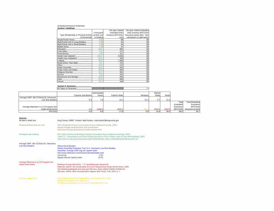
Embodied Emissions Worksheet
Section I: Buildings
Type (Residential) or Principal Activity
(Commercial)
# thousand
sq feet/ unit
or building
Life span related
embodied GHG
missions (MTCO2e/
unit)
Life span related embodied
GHG missions (MTCO2e/
thousand square feet) - See
calculations in table below
Single-Family Home................................ 2.53 98 39
Multi-Family Unit in Large Building ......... 0.85 33 39
Multi-Family Unit in Small Building ......... 1.39 54 39
Mobile Home.......................................... 1.06 41 39
Education .............................................. 25.6 991 39
Food Sales ............................................ 5.6 217 39
Food Service ......................................... 5.6 217 39
Health Care Inpatient ............................. 241.4 9,346 39
Health Care Outpatient .......................... 10.4 403 39
Lodging ................................................. 35.8 1,386 39
Retail (Other Than Mall).......................... 9.7 376 39
Office ..................................................... 14.8 573 39
Public Assembly .................................... 14.2 550 39
Public Order and Safety ......................... 15.5 600 39
Religious Worship .................................. 10.1 391 39
Service .................................................. 6.5 252 39
Warehouse and Storage ........................ 16.9 654 39
Other ..................................................... 21.9 848 39
Vacant ................................................... 14.1 546 39
Section II: Pavement.............................
All Types of Pavement............................ 50
Columns and Beams
Intermediate
Floors Exterior Walls Windows
Interior
Walls Roofs
Average GWP (lbs CO2e/sq ft): Vancouver,
Low Rise Building 5.3 7.8 19.1 51.2 5.7 21.3
Average Materials in a 2,272-square foot
single family home 0.0 2269.0 3206.0 285.0 6050.0 3103.0
Total
Embodied
Emissions
(MTCO2e)
Total Embodied
Emissions
(MTCO2e/
thousand sq feet)
MTCO2e 0.0 8.0 27.8 6.6 15.6 30.0 88.0 38.7
Sources
All data in black text King County, DNRP. Contact: Matt Kuharic, [email protected]
Residential floorspace per unit 2001 Residential Energy Consumption Survey (National Average, 2001)
Square footage measurements and comparisons
http://www.eia.doe.gov/emeu/recs/sqft-measure.html
Floorspace per building EIA, 2003 Commercial Buildings Energy Consumption Survey (National Average, 2003)
Table C3. Consumption and Gross Energy Intensity for Sum of Major Fuels for Non-Mall Buildings, 2003
http://www.eia.doe.gov/emeu/cbecs/cbecs2003/detailed_tables_2003/2003set9/2003excel/c3.xls
Average GWP (lbs CO2e/sq ft): Vancouver,
Low Rise Building Athena EcoCalculator
Athena Assembly Evaluation Tool v2.3- Vancouver Low Rise Building
Assembly Average GWP (kg) per square meter
http://www.athenasmi.ca/tools/ecoCalculator/index.html
Lbs per kg 2.20
Square feet per square meter 10.76
Average Materials in a 2,272-square foot
single family home Buildings Energy Data Book: 7.3 Typical/Average Household
Materials Used in the Construction of a 2,272-Square-Foot Single-Family Home, 2000
http://buildingsdatabook.eren.doe.gov/?id=view_book_table&TableID=2036&t=xls
See also: NAHB, 2004 Housing Facts, Figures and Trends, Feb. 2004, p. 7.
Average window size Energy Information Administration/Housing Characteristics 1993
Appendix B, Quality of the Data. Pg. 5.
ftp://ftp.eia.doe.gov/pub/consumption/residential/rx93hcf.pdf
Pavement Emissions Factors
MTCO2e/thousand square feet of asphalt
or concrete pavement 50 (see below)
Special Section: Estimating the Embodied Emissions for Pavement
Four recent life cycle assessments of the environmental impacts of roads form the basis for the per unit embodied emissions of pavement. Each study is constructed in slightly different ways; however, the aggregate results of the reports represent a reasonable estimate of the GHG emissions that are created from the manufacture of paving materials, construction related emissions, and maintenance of the pavement over its expected life cycle. The results of the studies are presented in different units and measures; considerable effort was undertaken to be able to compare the results of the studies in a reasonable way. For more details about the below methodology, contact [email protected]. The four studies, Meil (2001), Park (2003), Stripple (2001) and Treolar (2001) produced total GHG emissions of 4-34 MTCO2e per thousand square feet of finished paving (for similar asphalt and concrete based pavements). This estimate does not including downstream maintenance and repair of the highway. The average (for all concrete and asphalt pavements in the studies, assuming each study gets one data point) is ~17 MTCO2e/thousand square feet. Three of the studies attempted to thoroughly account for the emissions associated with long term maintenance (40 years) of the roads. Stripple (2001), Park et al. (2003) and Treolar (2001) report 17, 81, and 68 MTCO2e/thousand square feet, respectively, after accounting for maintenance of the roads. Based on the above discussion, King County makes the conservative estimate that 50 MTCO2e/thousand square feet of pavement (over the development’s life cycle) will be used as the embodied emission factor for pavement until better estimates can be obtained. This is roughly equivalent to 3,500 MTCO2e per lane mile of road (assuming the lane is 13 feet wide). It is important to note that these studies estimate the embodied emissions for roads. Paving that does not need to stand up to the rigors of heavy use (such as parking lots or driveways) would likely use less materials and hence have lower embodied emissions. Sources: Meil, J. A Life Cycle Perspective on Concrete and Asphalt Roadways: Embodied Primary Energy and
Global Warming Potential. 2006. Available: http://www.cement.ca/cement.nsf/eee9ec7bbd630126852566c40052107b/6ec79dc8ae03a782852572b90061b914/$FILE/ATTK0WE3/athena%20report%20Feb.%202%202007.pdf
Park, K, Hwang, Y., Seo, S., M.ASCE, and Seo, H. , “Quantitative Assessment of Environmental
Impacts on Life Cycle of Highways,” Journal of Construction Engineering and Management , Vol 129, January/February 2003, pp 25-31, (DOI: 10.1061/(ASCE)0733-9364(2003)129:1(25)).
Stripple, H. Life Cycle Assessment of Road. A Pilot Study for Inventory Analysis. Second Revised
Edition. IVL Swedish Environmental Research Institute Ltd. 2001. Available: http://www.ivl.se/rapporter/pdf/B1210E.pdf
Treloar, G., Love, P.E.D., and Crawford, R.H. Hybrid Life-Cycle Inventory for Road Construction and
Use. Journal of Construction Engineering and Management. P. 43-49. January/February 2004.
Embodied GHG Emissions…………………….Worksheet Background Information Buildings Embodied GHG emissions are emissions that are created through the extraction, processing, transportation, construction and disposal of building materials as well as emissions created through landscape disturbance (by both soil disturbance and changes in above ground biomass). Estimating embodied GHG emissions is new field of analysis; the estimates are rapidly improving and becoming more inclusive of all elements of construction and development. The estimate included in this worksheet is calculated using average values for the main construction materials that are used to create a typical family home. In 2004, the National Association of Home Builders calculated the average materials that are used in a typical 2,272 square foot single-family household. The quantity of materials used is then multiplied by the average GHG emissions associated with the life-cycle GHG emissions for each material. This estimate is a rough and conservative estimate; the actual embodied emissions for a project are likely to be higher. For example, at this stage, due to a lack of comprehensive data, the estimate does not include important factors such as landscape disturbance or the emissions associated with the interior components of a building (such as furniture). King County realizes that the calculations for embodied emissions in this worksheet are rough. For example, the emissions associated with building 1,000 square feet of a residential building will not be the same as 1,000 square feet of a commercial building. However, discussions with the construction community indicate that while there are significant differences between the different types of structures, this method of estimation is reasonable; it will be improved as more data become available. Additionally, if more specific information about the project is known, King County recommends two online embodied emissions calculators that can be used to obtain a more tailored estimate for embodied emissions: www.buildcarbonneutral.org and www.athenasmi.ca/tools/ecoCalculator/. Pavement Four recent life cycle assessments of the environmental impacts of roads form the basis for the per unit embodied emissions of pavement. Each study is constructed in slightly different ways; however, the aggregate results of the reports represent a reasonable estimate of the GHG emissions that are created from the manufacture of paving materials, construction related emissions, and maintenance of the pavement over its expected life cycle. For specifics, see the worksheet.

Energy Emissions Worksheet
Type (Residential) or Principal Activity
(Commercial)
Energy
consumption per
building per year
(million Btu)
Carbon
Coefficient for
Buildings
MTCO2e per
building per year
Floorspace
per Building
(thousand
square feet)
MTCE per
thousand
square feet per
year
MTCO2e per
thousand square
feet per year
Average
Building Life
Span
Lifespan Energy
Related MTCO2e
emissions per unit
Lifespan Energy
Related MTCO2e
emissions per
thousand square feet
Single-Family Home.............................. 107.3 0.108 11.61 2.53 4.6 16.8 57.9 672 266
Multi-Family Unit in Large Building ....... 41.0 0.108 4.44 0.85 5.2 19.2 80.5 357 422
Multi-Family Unit in Small Building ....... 78.1 0.108 8.45 1.39 6.1 22.2 80.5 681 489
Mobile Home.......................................... 75.9 0.108 8.21 1.06 7.7 28.4 57.9 475 448
Education .............................................. 2,125.0 0.124 264.2 25.6 10.3 37.8 62.5 16,526 646
Food Sales ............................................ 1,110.0 0.124 138.0 5.6 24.6 90.4 62.5 8,632 1,541
Food Service ......................................... 1,436.0 0.124 178.5 5.6 31.9 116.9 62.5 11,168 1,994
Health Care Inpatient ............................ 60,152.0 0.124 7,479.1 241.4 31.0 113.6 62.5 467,794 1,938
Health Care Outpatient ......................... 985.0 0.124 122.5 10.4 11.8 43.2 62.5 7,660 737
Lodging ................................................. 3,578.0 0.124 444.9 35.8 12.4 45.6 62.5 27,826 777
Retail (Other Than Mall)........................ 720.0 0.124 89.5 9.7 9.2 33.8 62.5 5,599 577
Office .................................................... 1,376.0 0.124 171.1 14.8 11.6 42.4 62.5 10,701 723
Public Assembly ................................... 1,338.0 0.124 166.4 14.2 11.7 43.0 62.5 10,405 733
Public Order and Safety ........................ 1,791.0 0.124 222.7 15.5 14.4 52.7 62.5 13,928 899
Religious Worship ................................. 440.0 0.124 54.7 10.1 5.4 19.9 62.5 3,422 339
Service .................................................. 501.0 0.124 62.3 6.5 9.6 35.1 62.5 3,896 599
Warehouse and Storage ....................... 764.0 0.124 95.0 16.9 5.6 20.6 62.5 5,942 352
Other ..................................................... 3,600.0 0.124 447.6 21.9 20.4 74.9 62.5 27,997 1,278
Vacant ................................................... 294.0 0.124 36.6 14.1 2.6 9.5 62.5 2,286 162
Sources
All data in black text King County, DNRP. Contact: Matt Kuharic, [email protected]
Energy consumption for residential
buildings 2007 Buildings Energy Data Book: 6.1 Quad Definitions and Comparisons (National Average, 2001)
Table 6.1.4: Average Annual Carbon Dioxide Emissions for Various Functions
http://buildingsdatabook.eren.doe.gov/
Data also at: http://www.eia.doe.gov/emeu/recs/recs2001_ce/ce1-4c_housingunits2001.html
Energy consumption for commercial
buildings EIA, 2003 Commercial Buildings Energy Consumption Survey (National Average, 2003)
and Table C3. Consumption and Gross Energy Intensity for Sum of Major Fuels for Non-Mall Buildings, 2003
Floorspace per building http://www.eia.doe.gov/emeu/cbecs/cbecs2003/detailed_tables_2003/2003set9/2003excel/c3.xls
Note: Data in plum color is found in both of the above sources (buildings energy data book and commercial buildings energy consumption survey).
Carbon Coefficient for Buildings Buildings Energy Data Book (National average, 2005)
Table 3.1.7. 2005 Carbon Dioxide Emission Coefficients for Buildings (MMTCE per Quadrillion Btu)
http://buildingsdatabook.eere.energy.gov/?id=view_book_table&TableID=2057
Note: Carbon coefficient in the Energy Data book is in MTCE per Quadrillion Btu.
To convert to MTCO2e per million Btu, this factor was divided by 1000 and multiplied by 44/12.
Residential floorspace per unit 2001 Residential Energy Consumption Survey (National Average, 2001)
Square footage measurements and comparisons
http://www.eia.doe.gov/emeu/recs/sqft-measure.html

average lief span of buildings,
estimated by replacement time method
Single Family
Homes
Multi-Family Units
in Large and
Small Buildings
All Residential
Buildings
New Housing
Construction,
2001 1,273,000 329,000 1,602,000
Existing Housing
Stock, 2001 73,700,000 26,500,000 100,200,000
Replacement
time: 57.9 80.5 62.5
(national
average, 2001)
Note: Single family homes calculation is used for mobile homes as a best estimate life span.
Note: At this time, KC staff could find no reliable data for the average life span of commercial buildings.
Therefore, the average life span of residential buildings is being used until a better approximation can be ascertained.
Sources:
New Housing
Construction,
2001 Quarterly Starts and Completions by Purpose and Design - US and Regions (Excel)
http://www.census.gov/const/quarterly_starts_completions_cust.xls
See also: http://www.census.gov/const/www/newresconstindex.html
Existing
Housing Stock,
2001 Residential Energy Consumption Survey (RECS) 2001
Tables HC1:Housing Unit Characteristics, Million U.S. Households 2001
Table HC1-4a. Housing Unit Characteristics by Type of Housing Unit, Million U.S. Households, 2001
Million U.S. Households, 2001
http://www.eia.doe.gov/emeu/recs/recs2001/hc_pdf/housunits/hc1-4a_housingunits2001.pdf
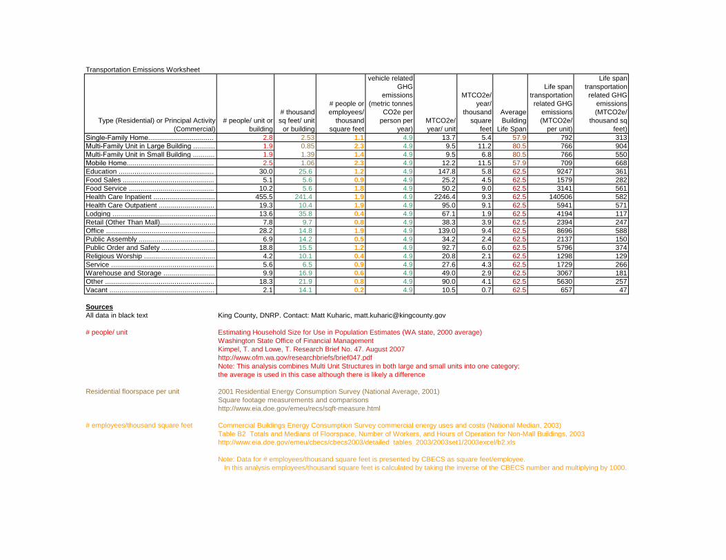
Transportation Emissions Worksheet
Type (Residential) or Principal Activity
(Commercial)
# people/ unit or
building
# thousand
sq feet/ unit
or building
# people or
employees/
thousand
square feet
vehicle related
GHG
emissions
(metric tonnes
CO2e per
person per
year)
MTCO2e/
year/ unit
MTCO2e/
year/
thousand
square
feet
Average
Building
Life Span
Life span
transportation
related GHG
emissions
(MTCO2e/
per unit)
Life span
transportation
related GHG
emissions
(MTCO2e/
thousand sq
feet)
Single-Family Home................................. 2.8 2.53 1.1 4.9 13.7 5.4 57.9 792 313
Multi-Family Unit in Large Building ........... 1.9 0.85 2.3 4.9 9.5 11.2 80.5 766 904
Multi-Family Unit in Small Building ........... 1.9 1.39 1.4 4.9 9.5 6.8 80.5 766 550
Mobile Home............................................ 2.5 1.06 2.3 4.9 12.2 11.5 57.9 709 668
Education ................................................ 30.0 25.6 1.2 4.9 147.8 5.8 62.5 9247 361
Food Sales .............................................. 5.1 5.6 0.9 4.9 25.2 4.5 62.5 1579 282
Food Service ........................................... 10.2 5.6 1.8 4.9 50.2 9.0 62.5 3141 561
Health Care Inpatient ............................... 455.5 241.4 1.9 4.9 2246.4 9.3 62.5 140506 582
Health Care Outpatient ............................ 19.3 10.4 1.9 4.9 95.0 9.1 62.5 5941 571
Lodging .................................................... 13.6 35.8 0.4 4.9 67.1 1.9 62.5 4194 117
Retail (Other Than Mall)............................ 7.8 9.7 0.8 4.9 38.3 3.9 62.5 2394 247
Office ....................................................... 28.2 14.8 1.9 4.9 139.0 9.4 62.5 8696 588
Public Assembly ...................................... 6.9 14.2 0.5 4.9 34.2 2.4 62.5 2137 150
Public Order and Safety ........................... 18.8 15.5 1.2 4.9 92.7 6.0 62.5 5796 374
Religious Worship .................................... 4.2 10.1 0.4 4.9 20.8 2.1 62.5 1298 129
Service .................................................... 5.6 6.5 0.9 4.9 27.6 4.3 62.5 1729 266
Warehouse and Storage .......................... 9.9 16.9 0.6 4.9 49.0 2.9 62.5 3067 181
Other ....................................................... 18.3 21.9 0.8 4.9 90.0 4.1 62.5 5630 257
Vacant ..................................................... 2.1 14.1 0.2 4.9 10.5 0.7 62.5 657 47
Sources
All data in black text King County, DNRP. Contact: Matt Kuharic, [email protected]
# people/ unit Estimating Household Size for Use in Population Estimates (WA state, 2000 average)
Washington State Office of Financial Management
Kimpel, T. and Lowe, T. Research Brief No. 47. August 2007
http://www.ofm.wa.gov/researchbriefs/brief047.pdf
Note: This analysis combines Multi Unit Structures in both large and small units into one category;
the average is used in this case although there is likely a difference
Residential floorspace per unit 2001 Residential Energy Consumption Survey (National Average, 2001)
Square footage measurements and comparisons
http://www.eia.doe.gov/emeu/recs/sqft-measure.html
# employees/thousand square feet Commercial Buildings Energy Consumption Survey commercial energy uses and costs (National Median, 2003)
Table B2 Totals and Medians of Floorspace, Number of Workers, and Hours of Operation for Non-Mall Buildings, 2003
http://www.eia.doe.gov/emeu/cbecs/cbecs2003/detailed_tables_2003/2003set1/2003excel/b2.xls
Note: Data for # employees/thousand square feet is presented by CBECS as square feet/employee.
In this analysis employees/thousand square feet is calculated by taking the inverse of the CBECS number and multiplying by 1000.

vehicle related GHG emissions
Estimate calculated as follows (Washington state, 2006)_
56,531,930,000 2006 Annual WA State Vehicle Miles Traveled
Data was daily VMT. Annual VMT was 365*daily VMT.
http://www.wsdot.wa.gov/mapsdata/tdo/annualmileage.htm
6,395,798 2006 WA state population
http://quickfacts.census.gov/qfd/states/53000.html
8839 vehicle miles per person per year
0.0506 gallon gasoline/mile
This is the weighted national average fuel efficiency for all cars and 2 axle, 4 wheel light trucks in 2005. This
includes pickup trucks, vans and SUVs. The 0.051 gallons/mile used here is the inverse of the more commonly
known term “miles/per gallon” (which is 19.75 for these cars and light trucks).
Transportation Energy Data Book. 26th Edition. 2006. Chapter 4: Light Vehicles and Characteristics. Calculations
based on weighted average MPG efficiency of cars and light trucks.
http://cta.ornl.gov/data/tedb26/Edition26_Chapter04.pdf
Note: This report states that in 2005, 92.3% of all highway VMT were driven by the above described vehicles.
http://cta.ornl.gov/data/tedb26/Spreadsheets/Table3_04.xls
24.3 lbs CO2e/gallon gasoline
The CO2 emissions estimates for gasoline and diesel include the extraction, transport, and refinement of petroleum
as well as their combustion.
Life-Cycle CO2 Emissions for Various New Vehicles. RENew Northfield.
Available: http://renewnorthfield.org/wpcontent/uploads/2006/04/CO2%20emissions.pdf
Note: This is a conservative estimate of emissions by fuel consumption because diesel fuel,
2205 with a emissions factor of 26.55 lbs CO2e/gallon was not estimated.
4.93 lbs/metric tonne
vehicle related GHG emissions (metric tonnes CO2e per person per year)
average lief span of buildings, estimated
by replacement time method See Energy Emissions Worksheet for Calculations
Commercial floorspace per unit EIA, 2003 Commercial Buildings Energy Consumption Survey (National Average, 2003)
Table C3. Consumption and Gross Energy Intensity for Sum of Major Fuels for Non-Mall Buildings, 2003
http://www.eia.doe.gov/emeu/cbecs/cbecs2003/detailed_tables_2003/2003set9/2003excel/c3.xls

Appendix C
TRANSPORTATION ANALYSIS
- 1 - November 15, 2017
TECHNICAL MEMORANDUM
Project: Grant County International Airport Industrial Master Plan
Subject: Transportation Analysis of Additional Parcels
Date: November 15, 2017
Authors: Marni C. Heffron, P.E., P.T.O.E. The Environmental Impact Statement for the Grant County International Airport Employment Center Project1 (referred to herein as the EIS) evaluated the impacts of development on 1,258 acres near the air-port. Three additional parcels, with total size of approximately 90 acres that were not included in the prior EIS, are now being evaluated. This memorandum evaluates the potential transportation impacts of the three additional parcels and determines if any additional transportation improvements beyond those previously identified in the EIS would be needed to accommodate the additional growth.
1. Development Potential
The EIS evaluated two development alternatives, Alternative 1 with lower-density heavy manufacturing and warehousing, and Alternative 2 with higher-density light manufacturing. The key metrics of the EIS alternatives that affect transportation—net new building square footage and net new employment—are summarized in Table 1. As shown, the prior EIS evaluated alternatives that could increase employment by up to 19,000 people. On the three additional parcels under consideration, existing buildings with about 540,500 square feet (sf) of space are occupied by Terex Washington, Inc. (Genie) and Chemi-con Materials. It is estimated that the three subject parcels could accommodate an additional 241,400 sf of building area with about 525 employees, as summarized in Table 1.
1 Port of Moses Lake and Grant County, Final EIS, November 2015.

Grant County International Airport Industrial Master Plan Transportation Analysis of Additional Parcels
- 2 - November 15, 2017
Table 1. Development Alternatives in EIS and Additional Parcels
Evaluated in EIS a New Analysis
Metric
Alternative 1 Heavy Manufacturing/ Warehouse Emphasis
Alternative 2 Light Manufacturing/
Technology Emphasis Potential on
Three Additional Parcels b
Total Acreage 1,258 1,258 90
Net New Building Area 8,809,700 sf 10,085,300 sf 241,400 sf c
Net New Employees 13,519 19,010 525 a. From Environmental Impact Statement for the Grant County International Airport Employment Center Project, November 2015. b. Source: Reid Middleton, September 2017. c. Net new building area would be in addition to approximately 540,500 sf of buildings that are present on the three parcels.
2. Summary of Prior Transportation Analysis and Recommendations
Detailed transportation analysis was performed for the EIS, including evaluation of near-site roadways and connections to State Route (SR) 17, and traffic operations analysis at key intersections along Stratford Road NE, SR 17, and Randolph Road NE. It assessed the potential trip generation impacts associated with Alternatives 1 and 2, and then determined roadway improvements that would be needed to accommodate the commuter trips resulting from the increased employment.
2.1. Intersection Needs Analysis
Table 2 (excerpted Table 3.10-7 of the EIS) summarizes the intersection control identified in the EIS that would be needed at various levels of development.
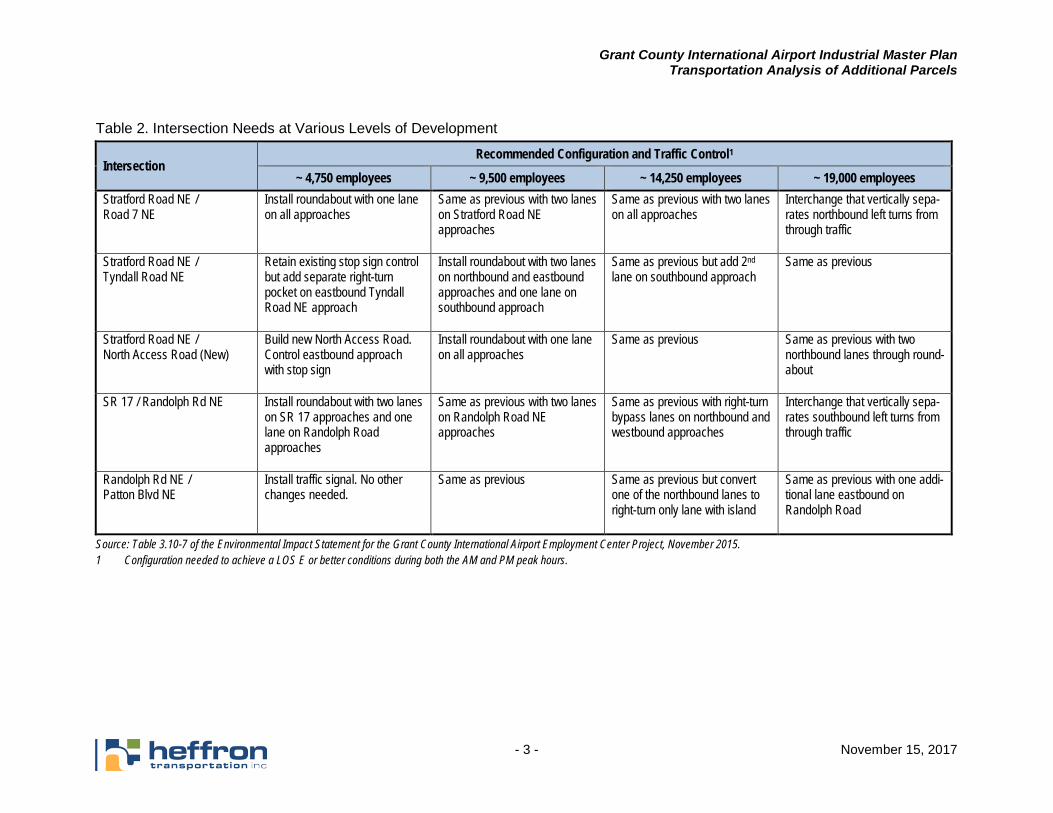
Grant County International Airport Industrial Master Plan Transportation Analysis of Additional Parcels
- 3 - November 15, 2017
Table 2. Intersection Needs at Various Levels of Development
Intersection Recommended Configuration and Traffic Control1
~ 4,750 employees ~ 9,500 employees ~ 14,250 employees ~ 19,000 employees Stratford Road NE / Road 7 NE
Install roundabout with one lane on all approaches
Same as previous with two lanes on Stratford Road NE approaches
Same as previous with two lanes on all approaches
Interchange that vertically sepa-rates northbound left turns from through traffic
Stratford Road NE / Tyndall Road NE
Retain existing stop sign control but add separate right-turn pocket on eastbound Tyndall Road NE approach
Install roundabout with two lanes on northbound and eastbound approaches and one lane on southbound approach
Same as previous but add 2nd lane on southbound approach
Same as previous
Stratford Road NE / North Access Road (New)
Build new North Access Road. Control eastbound approach with stop sign
Install roundabout with one lane on all approaches
Same as previous Same as previous with two northbound lanes through round-about
SR 17 / Randolph Rd NE Install roundabout with two lanes on SR 17 approaches and one lane on Randolph Road approaches
Same as previous with two lanes on Randolph Road NE approaches
Same as previous with right-turn bypass lanes on northbound and westbound approaches
Interchange that vertically sepa-rates southbound left turns from through traffic
Randolph Rd NE / Patton Blvd NE
Install traffic signal. No other changes needed.
Same as previous Same as previous but convert one of the northbound lanes to right-turn only lane with island
Same as previous with one addi-tional lane eastbound on Randolph Road
Source: Table 3.10-7 of the Environmental Impact Statement for the Grant County International Airport Employment Center Project, November 2015. 1 Configuration needed to achieve a LOS E or better conditions during both the AM and PM peak hours.
Grant County International Airport Industrial Master Plan Transportation Analysis of Additional Parcels
- 4 - November 15, 2017
A sensitivity analysis was performed for the EIS that determined a new North Access Road to the in-dustrial area would be needed after total employment of the developed area exceeds 9,500 people. The EIS determined that capacity improvements would likely be needed at the existing interchange of SR 17/Stratford Road NE with higher levels of development. However, the specific improvements would be highly dependent upon where employees live. The potential employment levels under Alter-natives 1 and 2, which could range up to 19,000 people, could dramatically affect residential land use patterns in the central core area of Moses Lake, adding density to existing neighborhoods. If that occurs, capacity improvements along Stratford Road NE could be needed. If residential growth is spread over a larger area, more trips to and from the site could use the SR 17 ramps. In addition, increased density in the Moses Lake city center would increase opportunities to serve employee trips with transit, reducing the need for some roadway capacity improvements. It is likely that the Washington State Department of Transportation (WSDOT) would require that transit strategies and/or demand management measures targeting employee commute trips be implemented to the extent feasible, before interchange capacity improvements would be considered. Determining the potential residential land use implications and future transit service were beyond the scope of the EIS. Therefore, the EIS recommended that Grant County partner with the City of Moses Lake and WSDOT to perform detailed analysis of the SR 17/Stratford Road NE interchange in consideration of the future land use and transit paradigms.
2.2. Transportation Mitigation Recommendations from EIS
The following summarizes the transportation mitigation measures identified in the EIS.
Pre-Development Activities
• Prior to development, an implementation and funding plan for the phased transportation mitigation package would be prepared.
• Grant County would consider partnering with the City of Moses Lake and WSDOT to per-form detailed study of the SR 17/Stratford Road NE interchange.
Transportation Improvements
• Intersections would be improved per the threshold guidance listed in Table 3.10-7 (see Table 2 above). The potential North Access Road could be deferred until development reaches approximately 9,500 employees.
• Stratford Road NE and SR 17 would be widened, as needed, between and adjacent to improved intersections to increase capacity.
• Truck movements would be provided for at all new roundabouts and intersections.
• The Port of Moses Lake, City of Moses Lake, and Grant County would work with Grant Transit Authority to extend existing routes from Big Bend Community College to the site, or to establish new routes when demand warrants.
• Pedestrian facilities would be constructed on at least one side of new roads developed for the project. The optimal location for new crosswalks at intersections would be assessed during the design of those improvements.

Grant County International Airport Industrial Master Plan Transportation Analysis of Additional Parcels
- 5 - November 15, 2017
3. Analysis of Additional Parcels
3.1. Trip Generation
To be consistent with the EIS analysis, trip generation equations for Manufacturing (Land Use Code 140) from the Trip Generation Manual2 were applied to the net new employment. These rates reflect a range of potential industrial uses. Trip generation for the three new parcels is summarized in Table 3. These are compared to the total trip generation estimated for the EIS alternatives. As shown, the three additional parcels are estimated to generate about 1,100 vehicle trips per day with 210 trips during the AM peak hour and 190 trips during the PM peak hour. This represents an increase of about 3% com-pared to the trips evaluated for the EIS alternatives.
Table 3. Trip Generation for Additional Parcels vs. EIS Trip Generation Assumptions
Land Use
Daily AM Peak Hour Trips PM Peak Hour Trips
Trips In Out Total In Out Total
Trip Generation for Three Added Parcels a
Pass Vehicle Trips 990 150 56 206 80 106 186
Truck Trips 110 0 4 4 0 4 4
Total Trips 1,110 150 60 210 80 110 190
EIS Alternative 1 - Heavy Manufacturing / Warehouse Emphasis b
Pass Vehicle Trips 25,920 3,870 1,430 5,300 2,100 2,670 4,770
Truck Trips 2,880 80 30 110 40 60 100
Total Trips 28,800 3,950 1,460 5,410 2,140 2,730 4,870
EIS Alternative 2 - Light Manufacturing / Technology Emphasis b
Pass Vehicle Trips 36,450 5,440 2,010 7,450 2,950 3,750 6,700
Truck Trips 4,050 110 40 150 60 80 140
Total Trips 40,500 5,550 2,050 7,600 3,010 3,830 6,840 a. Trips determined using rates for Manufacturing use in the Institute of Transportation Engineers (ITE), Trip Generation, 9th Edition, 2010. b. Source: Table 3.10-5 of the Environmental Impact Statement for the Grant County International Airport Employment Center Project,
November 2015. Trips generated by the three parcels were distributed to the transportation system using the trip distribu-tion pattern shown on the EIS Figure 3.10-3. The trip assignment for the additional trips is shown on Figure 1.
2 Institute of Transportation Engineers (ITE), 9th Edition, 2010.

N
G r a n t C o u n t yInternational AirportEmployment Center
Randolph Rd NE
Rd 7 NE
Tyndall Rd NE
Str
atfo
rd R
oad
NE
( R
oad
J N
E)
SR 17
Patto
nB
lvdN
E
Grant CountyInternationalAirport
Three Added Parcels
Area Evaluatedfor EIS
N Access Rd
Figure 1Trips Generated by
Three Additional Parcels
Daily TripsXXXX
40
75(40)
5(5)
10(5)
(25)50
10 (5)
25 (35)
20 (30)
5 (5)
0 (5)
(55) 30
(10) 5
(30) 60
(5) 0
(0)5
AM Peak Hour TripsPM Peak Hour Trips
XX(XX)
Legend
Employment Center Boundary
90
40
630
50
70
320
440
540

Grant County International Airport Industrial Master Plan Transportation Analysis of Additional Parcels
- 7 - November 15, 2017
3.2. Operational Impacts
Roadway operational analysis presented in the EIS provided the basis for determining the roadway and intersection capacity improvements. Capacity thresholds for different roadway configurations were used to assess future needs for both Stratford Road NE and SR 17, which would accommodate the highest volumes of project-generated traffic. The analysis from the EIS was updated to reflect increased traffic generated by the three additional parcels. Figures 2 and 3, which show capacity needs for future traffic growth on Stratford Road NE and SR 17 respectively, show that the additional development on the three parcels would have very little impact on the capacity needs of the roadways. The added traffic would not change the results or recommended improvements in the EIS.
Figure 2. Volume vs Capacity on Stratford Road NE
Source: Heffron Transportation, Inc., September 2017. The capacities of various lane configurations are from Table 3.10-6 of the Environmental Impact Statement for the Grant County International Airport Employment Center Project, November 2015.
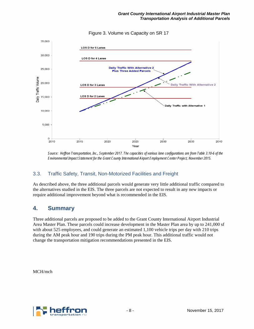
Grant County International Airport Industrial Master Plan Transportation Analysis of Additional Parcels
- 8 - November 15, 2017
Figure 3. Volume vs Capacity on SR 17
Source: Heffron Transportation, Inc., September 2017. The capacities of various lane configurations are from Table 3.10-6 of the Environmental Impact Statement for the Grant County International Airport Employment Center Project, November 2015.
3.3. Traffic Safety, Transit, Non-Motorized Facilities and Freight
As described above, the three additional parcels would generate very little additional traffic compared to the alternatives studied in the EIS. The three parcels are not expected to result in any new impacts or require additional improvement beyond what is recommended in the EIS.
4. Summary
Three additional parcels are proposed to be added to the Grant County International Airport Industrial Area Master Plan. These parcels could increase development in the Master Plan area by up to 241,000 sf with about 525 employees, and could generate an estimated 1,100 vehicle trips per day with 210 trips during the AM peak hour and 190 trips during the PM peak hour. This additional traffic would not change the transportation mitigation recommendations presented in the EIS. MCH/mch