poplar bluff accesses - missouri department of … poplar bluff accesses management plan •:•...
TRANSCRIPT

Poplar Bluff Accesses Chalk Bluff Trail Access
Dan River Access Fisk Access
Harviell Access Hilliard Access
James Clark Access Ringo Ford Access
Fifteen-Year Area Management Plan FY 2018-2032
~ - IY - l"l Forestry Division Chief Date
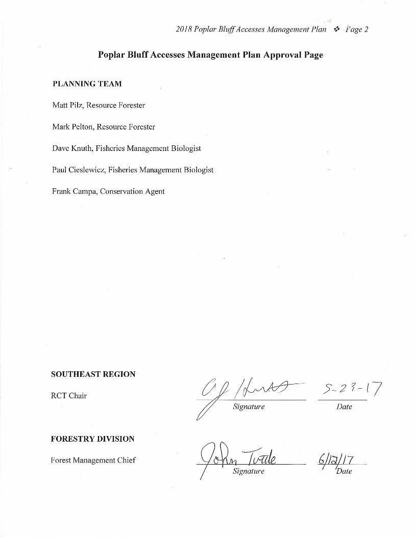
2018 Poplar Bluff Accesses Management Plan •:• Page 2
Poplar Bluff Accesses Management Plan Approval Page
PLANNING TEAM
Matt Pilz, Resource Forester
Mark Pelton, Resource Forester
Dave Knuth, Fisheries Management Biologist
Paul Cieslewicz, Fisheries Management Biologist
Frank Campa, Conservation Agent
SOUTHEAST REGION
VJ/~ 7 Signature
RCT Chair
Date
FORESTRY DIVISION
Forest Management Chief ~/J;;j/7 Date

2018 Poplar Bluff Accesses Management Plan Page 3
OVERVIEW
Area Name Area Number
Year Acquired
Acreage County Administrative Responsibility
Maintenance Responsibility
Chalk Bluff Trail Access
9226 1993 82 Dunklin Forestry Forestry
Dan River Access
9327 1992 68 Butler Forestry Forestry
Fisk Access 7003 19711 4 Butler Forestry Forestry Harviell Access
8511 1984 35 Butler Forestry Forestry
Hilliard Access
6614 19662 1 Butler Forestry Forestry
James Clark Access
200514 2004 12 Butler Fisheries Fisheries
Ringo Ford Access
9109 19903 1 Butler Forestry Forestry
1 These access are owned by the Inter-River Drainage District and leased to the Missouri Department of Conservation (Department). Year acquired indicates the beginning date of this lease. 2 This access is owned by the Missouri Department of Transportation and leased to the Department since 1966. 3 This access is owned by the Missouri Department of Transportation and leased to the Department since 1990. Statements of Purpose:
A. Strategic Direction These areas are managed to provide healthy bottomland forest habitat for species of conservation concern and to provide fishing and boating access to Cane Creek, St. Francis River, Black River, and Little Black River.
B. Desired Future Condition The desired future condition of the Poplar Bluff Accesses is to maintain healthy bottomland forests and provide fishing and boating access for the Poplar Bluff area.
C. Federal Aid Statement • Dan River Access: This area, or a portion thereof, was acquired with federal funds
and donated to the state to provide fish and wildlife benefits and land conservation. • Chalk Bluff Trail Access, Fisk Access, Harviell Access, Hilliard Access, James Clark
Access, Ringo Ford Access: N/A

2018 Poplar Bluff Accesses Management Plan Page 4
GENERAL INFORMATION AND CONDITIONS
I. Special Considerations Area Name Priority Areas Natural Areas Chalk Bluff Trail Access Saint Francis River Stream Conservation
Opportunity Area None
Dan River Access Black River Stream Conservation Opportunity Area
None
Fisk Access Saint Francis River Stream Conservation Opportunity Area
None
Harviell Access Black River Stream Conservation Opportunity Area
None
Hilliard Access Priority Forest Landscape None James Clark Access Saint Francis River Stream Conservation
Opportunity Area None
Ringo Ford Access None None
II. Important Natural Features and Resources Area Name Species of Conservation Concern Caves Springs Chalk Bluff Trail Access Yes1 None None Dan River Access Yes1 None None Fisk Access Yes1 None None Harviell Access Yes1 None None Hilliard Access Yes1 None None James Clark Access Yes1 None None Ringo Ford Access Yes1 None None 1Species of conservation concern are known from this area. Area managers should consult the Natural Heritage Database annually and review all management activities with the natural history biologist.
III. Existing Infrastructure Area Name Parking Lots Concrete
Boat Ramp Privy Pond/Lake
Chalk Bluff Trail Access 11 1 11 None Dan River Access 11 11 11 1-acre fishless pond Fisk Access 1 1 None None Harviell Access 1 1 None None Hilliard access 1 1 None None James Clark Access 1 12 None None Ringo Ford Access 1 None3 None None 1Americans with Disabilities Act (ADA) accessible 2Ramp is a canoe/small johnboat hand launch. There is no trailer launch. 3Canoe launch only. No access to river for trailers.
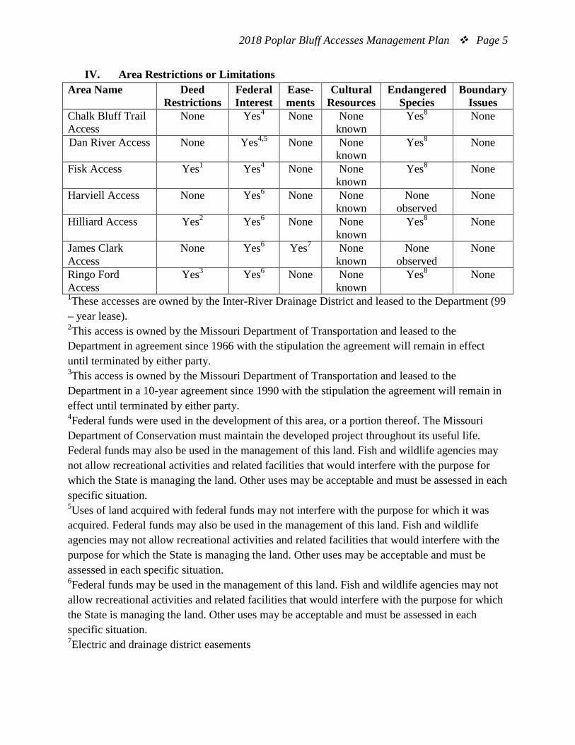
2018 Poplar Bluff Accesses Management Plan Page 5
IV. Area Restrictions or Limitations Area Name Deed
Restrictions Federal Interest
Ease-ments
Cultural Resources
Endangered Species
Boundary Issues
Chalk Bluff Trail Access
None Yes4 None None known
Yes8 None
Dan River Access None Yes4,5 None None known
Yes8 None
Fisk Access Yes1 Yes4 None None known
Yes8 None
Harviell Access None Yes6 None None known
None observed
None
Hilliard Access Yes2 Yes6 None None known
Yes8 None
James Clark Access
None Yes6 Yes7 None known
None observed
None
Ringo Ford Access
Yes3 Yes6
None None known
Yes8 None
1These accesses are owned by the Inter-River Drainage District and leased to the Department (99 – year lease). 2This access is owned by the Missouri Department of Transportation and leased to the Department in agreement since 1966 with the stipulation the agreement will remain in effect until terminated by either party. 3This access is owned by the Missouri Department of Transportation and leased to the Department in a 10-year agreement since 1990 with the stipulation the agreement will remain in effect until terminated by either party. 4Federal funds were used in the development of this area, or a portion thereof. The Missouri Department of Conservation must maintain the developed project throughout its useful life. Federal funds may also be used in the management of this land. Fish and wildlife agencies may not allow recreational activities and related facilities that would interfere with the purpose for which the State is managing the land. Other uses may be acceptable and must be assessed in each specific situation. 5Uses of land acquired with federal funds may not interfere with the purpose for which it was acquired. Federal funds may also be used in the management of this land. Fish and wildlife agencies may not allow recreational activities and related facilities that would interfere with the purpose for which the State is managing the land. Other uses may be acceptable and must be assessed in each specific situation. 6Federal funds may be used in the management of this land. Fish and wildlife agencies may not allow recreational activities and related facilities that would interfere with the purpose for which the State is managing the land. Other uses may be acceptable and must be assessed in each specific situation. 7Electric and drainage district easements

2018 Poplar Bluff Accesses Management Plan Page 6 8Endangered species are known from this area. Area managers should consult the Natural Heritage Database annually and review all management activities with the natural history biologist.
MANAGEMENT CONSIDERATIONS
V. Terrestrial Resource Management Considerations
Challenges and Opportunities: 1) Manage bottomland forests for a variety of species characteristic of the natural
communities. 2) Monitor and control invasive species. 3) Monitor tree plantings and natural succession in old field sections.
Management Objective 1: Provide bottomland forest habitat for a broad array of species, characteristic of the natural communities found in the areas, including habitat suitable for species of conservation concern.
Strategy 1: Allow areas to develop naturally and intervene when management is deemed necessary to meet habitat goals. (Forestry) Strategy 2: Complete a forest inventory of areas after a given period of time (15-20 years) to determine if management activities are necessary. (Forestry)
Management Objective 2: Monitor and control the spread of invasive species Strategy 1: Monitor annually for invasive species occurrences and treat as needed. (Forestry)
Management Objective 3: Monitor tree plantings and natural succession in old field sections of the access.
Strategy 1: Plant additional bottomland tree species seedlings if necessary. (Forestry) Strategy 2: Thin seeded trees as needed. (Forestry)
VI. Aquatic Resource Management Considerations
Challenges and Opportunities: 1) Manage the riparian corridor to provide quality stream bank stability. 2) Maintain fishless area ponds for wildlife watering and semi-aquatic wildlife use.

2018 Poplar Bluff Accesses Management Plan Page 7
Management Objective 1: Maintain riparian corridors along streams on the areas and prevent soil erosion during any land disturbances.
Strategy 1: Monitor forest health in the riparian buffer zone and implement any necessary forest best management practices, if practical to ensure adequate tree health, composition, and density. (Forestry) Strategy 2: Follow the Missouri Department of Conservation’s (the Department’s) Missouri watershed protection practices recommended for Missouri forests: 2014 management guidelines for maintaining forested watersheds to protect streams manual (Missouri Department of Conservation, 2014) when maintaining and constructing roadways and conducting timber harvests. (Forestry)
Management Objective 2: Monitor aquatic species of conservation concern and update the Natural Heritage database as necessary.
Strategy 1: Assess aquatic organism populations to determine their presence and population stability. Both fisheries biologists and natural history biologists will work together to accomplish the monitoring. (Fisheries, Wildlife)
Management Objective 3: Manage all fishless waters on the area for amphibian and wildlife benefits.
Strategy 1: Maintain ponds incapable of supporting quality fisheries for amphibians, reptiles, and other wildlife. (Forestry, Fisheries)
VII. Public Use Management Considerations
Challenges and Opportunities:
1) Provide boating and fishing access to rivers in the Poplar Bluff area.
Management Objective 1: Maintain the public accesses and provide public use opportunities in accordance with area rules and regulations.
Strategy 1: Maintain the area facilities and public accesses in accordance with the Area Resource Management Manual. (Forestry)
VIII. Administrative Considerations
Challenges and Opportunities: 1) Maintain area facilities for public use and enjoyment. 2) Maintain area boundaries so that they are easy to identify for the public. 3) Consider land acquisition, when available.

2018 Poplar Bluff Accesses Management Plan Page 8
Management Objective 1: Maintain area facilities for public use and enjoyment. Strategy 1: Maintain all welcome signs, bulletin boards, and rules and regulations signage. (Forestry)
Management Objective 2: Maintain area boundaries so that they are easy to identify for the public.
Strategy 1: Area boundaries will be blazed, painted, and signed with Department signs. (Forestry)
Lands Proposed for Acquisition: When available, adjacent land may be considered for acquisition from willing sellers. Tracts that improve area access, provide public use opportunities, contain unique natural communities and/or species of conservation concern, or meet other Department priorities, as identified in the annual Department land acquisition priorities, may be considered.
MANAGEMENT TIMETABLE
Strategies are considered ongoing unless listed in the following table: FY
18 FY19
FY20
FY21
FY22
FY23
FY24
FY25
FY26
FY27
FY28
FY29
FY30
FY31
FY32
Administrative Considerations Objective 2 Strategy 1 X X X X X
2018 Poplar Bluff Accesses Management Plan Page 9
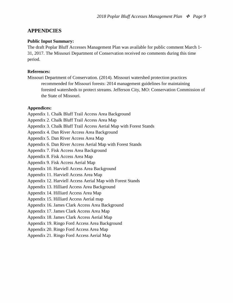
APPENDCIES
Public Input Summary: The draft Poplar Bluff Accesses Management Plan was available for public comment March 1-31, 2017. The Missouri Department of Conservation received no comments during this time period. References: Missouri Department of Conservation. (2014). Missouri watershed protection practices recommended for Missouri forests: 2014 management guidelines for maintaining forested watersheds to protect streams. Jefferson City, MO: Conservation Commission of the State of Missouri. Appendices: Appendix 1. Chalk Bluff Trail Access Area Background Appendix 2. Chalk Bluff Trail Access Area Map Appendix 3. Chalk Bluff Trail Access Aerial Map with Forest Stands Appendix 4. Dan River Access Area Background Appendix 5. Dan River Access Area Map Appendix 6. Dan River Access Aerial Map with Forest Stands Appendix 7. Fisk Access Area Background Appendix 8. Fisk Access Area Map Appendix 9. Fisk Access Aerial Map Appendix 10. Harviell Access Area Background Appendix 11. Harviell Access Area Map Appendix 12. Harviell Access Aerial Map with Forest Stands Appendix 13. Hilliard Access Area Background Appendix 14. Hilliard Access Area Map Appendix 15. Hilliard Access Aerial map Appendix 16. James Clark Access Area Background Appendix 17. James Clark Access Area Map Appendix 18. James Clark Access Aerial Map Appendix 19. Ringo Ford Access Area Background Appendix 20. Ringo Ford Access Area Map Appendix 21. Ringo Ford Access Aerial Map

2018 Poplar Bluff Accesses Management Plan Page 10
Appendix 1. Chalk Bluff Trail Access Area Background This area is of adequate size to promote active resource management. Chalk Bluff Trail Access is comprised of eight stands:
• Stand 1 is a 12-acre stand that contains oak and sweet gum timber; • Stand 2 is a 13-acre stand that contains upland highly erosive hillside; • Stand 3 is a 5-acre stand that contains a section of bottomland forest along St. Francis
River; • Stand 4 is a 15-acre stand that contains directed seeded with oak; • Stand 5 is a 2-acre stand that contains remnant oak and sweetgum timber; • Stand 6 is a 7-acre stand that was contracted and seeded with oak. Vine growth has
become a problem and many trees have become overtopped with vine growth. • Stand 7 is a 10-acre stand that is composed of remnant oak, sweetgum, and other
bottomland hardwood timber. • Stand 8 is a 14-acre stand that was contracted and seeded with oak. Growth of vines has
become a problem in the eastern half of the stand and some trees have become overtopped with vines.
This area is mostly old fields. Facilities/features: boat ramp, a permanent stream (St. Francis River). Current Land and Water Types:
Land/Water Type Acres Miles % of Area Forest and Woodland 77 93 Old Field 6 7 Total 83 100 Stream Frontage 0.7

2018 Poplar Bluff Accesses Management Plan Page 11
Appendix 2. Chalk Bluff Trail Access Area Map

2018 Poplar Bluff Accesses Management Plan Page 12
Appendix 3. Chalk Bluff Trail Access Aerial Map with Forest Stands
2018 Poplar Bluff Accesses Management Plan Page 13
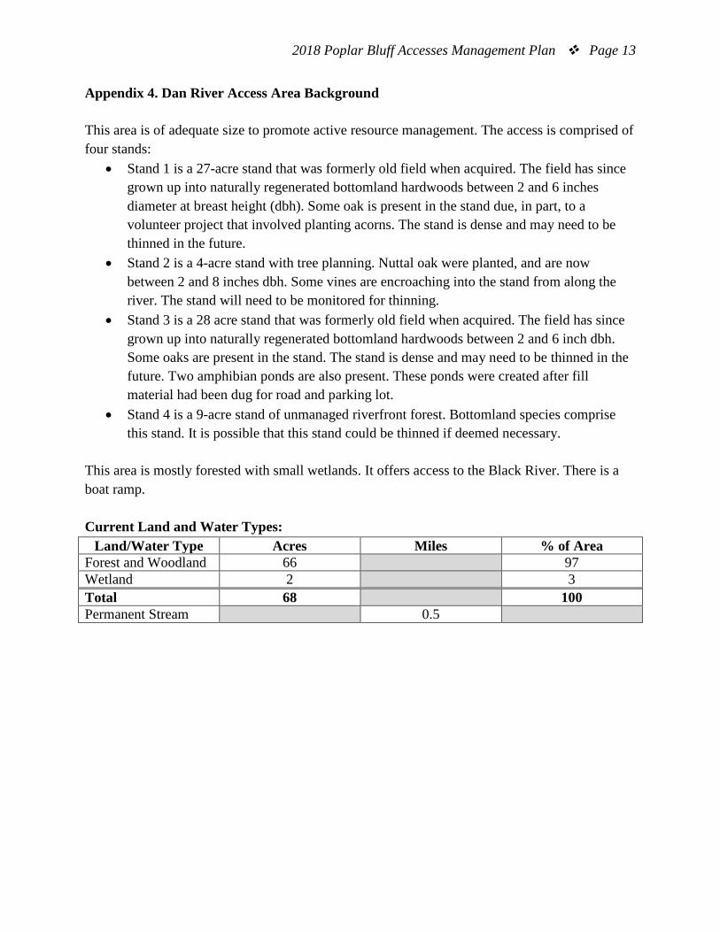
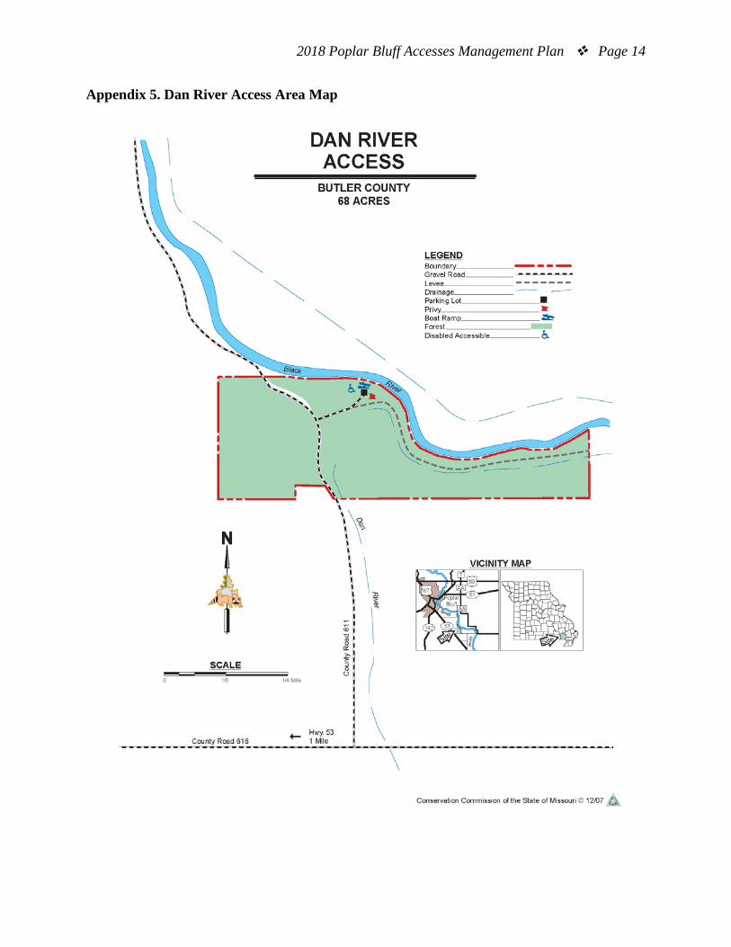
Appendix 4. Dan River Access Area Background This area is of adequate size to promote active resource management. The access is comprised of four stands:
• Stand 1 is a 27-acre stand that was formerly old field when acquired. The field has since grown up into naturally regenerated bottomland hardwoods between 2 and 6 inches diameter at breast height (dbh). Some oak is present in the stand due, in part, to a volunteer project that involved planting acorns. The stand is dense and may need to be thinned in the future.
• Stand 2 is a 4-acre stand with tree planning. Nuttal oak were planted, and are now between 2 and 8 inches dbh. Some vines are encroaching into the stand from along the river. The stand will need to be monitored for thinning.
• Stand 3 is a 28 acre stand that was formerly old field when acquired. The field has since grown up into naturally regenerated bottomland hardwoods between 2 and 6 inch dbh. Some oaks are present in the stand. The stand is dense and may need to be thinned in the future. Two amphibian ponds are also present. These ponds were created after fill material had been dug for road and parking lot.
• Stand 4 is a 9-acre stand of unmanaged riverfront forest. Bottomland species comprise this stand. It is possible that this stand could be thinned if deemed necessary.
This area is mostly forested with small wetlands. It offers access to the Black River. There is a boat ramp. Current Land and Water Types:
Land/Water Type Acres Miles % of Area Forest and Woodland 66 97 Wetland 2 3 Total 68 100 Permanent Stream 0.5
2018 Poplar Bluff Accesses Management Plan Page 14
Appendix 5. Dan River Access Area Map

2018 Poplar Bluff Accesses Management Plan Page 15
Appendix 6. Dan River Access Aerial Map with Forest Stands

2018 Poplar Bluff Accesses Management Plan Page 16
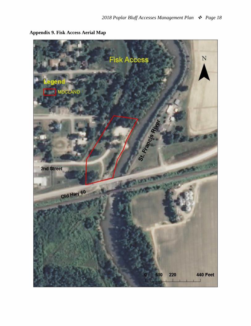
Appendix 7. Fisk Access Area Background This access is owned by Inter-River Drainage District and is managed by the Department. No resource management is currently occurring at this location due to the area’s small size. If tree health is threatened, action may be taken to mitigate threat. This area offers access to the St. Francis River. There is a boat ramp. Current Land and Water Types: Land/Water Type Acres Miles % of Area Old Field 2 50 Forest and Woodland 2 50 Total 4 100 Permanent Stream 0.1

2018 Poplar Bluff Accesses Management Plan Page 17
Appendix 8. Fisk Access Area Map
2018 Poplar Bluff Accesses Management Plan Page 18
Appendix 9. Fisk Access Aerial Map
2018 Poplar Bluff Accesses Management Plan Page 19
Appendix 10. Harviell Access Area Background This area is of adequate size to promote active resource management. The access is comprised of seven stands:
• Stand 1is a 1-acre food plot that was maintained between 2001 and 2006. This food plot may be used periodically in the future.
• Stand 2 is a 5-acre demonstration tree planting. Seedlings of green ash, cherrybark oak, nuttal oak, and bald cypress were planted, as well as cherrybark oak seed. These trees were planted in different orientations and are subjected to different treatments, including mowing around, mowing in addition to providing a one-year chemical treatment, mowing in addition to providing a three-year chemical treatment, and mowing in addition to a three-year chemical treatment and providing a cover crop. A forest thinning was completed in 2010. Goals are to maintain proper spacing through tree thinning.
• Stand 3 is a 5-acre stand that was direct seeded with oak in 1990. A crop tree release forest thinning was completed in 2008. Goals for the future are to maintain proper spacing through tree thinning.
• Stand 4 is a 7-acre stand. Most of the stand was planted in oak between 1993 and 1995. In 2008 most of the stand was treated with crop tree release forest thinning. Goals for the future are to maintain proper spacing through tree thinning.
• Stand 5 is a 3-acre stand that was planted with black walnut seedlings in 1990. Trees were thinned and mowed around between 1992 and 2011. Goals for the future are to maintain proper spacing through tree thinning.
• Stand 6 is a 4-acre stand that was planted with black walnut seedlings in 1990. Trees were thinned and mowed between 1992 and 2009. Goals for the future are to maintain proper spacing through tree thinning
• Stand 7 is a 6-acre stand that has been left to regenerate naturally. Goals for the future are to maintain proper spacing through tree thinning.
This forest area offers access to Cane Creek. There is a boat ramp. Current Land and Water Types:
Land Type Acres Miles % of Area Forest and Woodland 35 100 Permanent Stream 0.75

2018 Poplar Bluff Accesses Management Plan Page 20
Appendix 11. Harviell Access Area Map

2018 Poplar Bluff Accesses Management Plan Page 21
Appendix 12. Harviell Access Aerial Map with Forest Stands

2018 Poplar Bluff Accesses Management Plan Page 22
Appendix 13. Hilliard Access Area Background This access is owned by the Missouri Department of Transportation and is managed by the Department. No resource management is currently occurring at this location due to the area’s small size. If tree health is threatened, action may be taken to mitigate threat. Hilliard Access is 2 miles north of Poplar Bluff on Route W. This area offers access to the Black River. There is a boat ramp. Current Land and Water Types:
Land/Water Type Acres Miles % of Area Other (road, parking lot) 1 67 Forest 0.5 33 Total 1.5 100 Stream – Permanent 0.01

2018 Poplar Bluff Accesses Management Plan Page 23
Appendix 14. Hilliard Access Area Map

2018 Poplar Bluff Accesses Management Plan Page 24
Appendix 15. Hilliard Access Aerial Map

2018 Poplar Bluff Accesses Management Plan Page 25
Appendix 16. James Clark Access Area Background No resource management is currently occurring at this location due to the area’s small size. If forest health is threatened, action may be taken to manage a small section of timber. This St. Francis River site is a donation from the Clark family in memory of their husband and father. This is a hand launch site only. Current Land and Water Types:
Land/Water Type Acres Miles % of Area Forest and Woodland 10 83 Old Field 2 17 Total 12 100 Permanent Stream 0.25

2018 Poplar Bluff Accesses Management Plan Page 26
Appendix 17. James Clark Access Area Map

2018 Poplar Bluff Accesses Management Plan Page 27
Appendix 18. James Clark Access Aerial Map

2018 Poplar Bluff Accesses Management Plan Page 28
Appendix 19. Ringo Ford Access Area Background This access is owned by the Missouri Department of Transportation and managed by the Department. No resource management is currently occurring at this location due to size. If tree health is threatened, action may be taken to mitigate threat. Current Land and Water Types:
Land/Water Type Acres Miles % of Area Forest and Open 0.5 50 Other (road, parking lot) 0.5 50 Total 1.0 100 Permanent Stream 0.2

2018 Poplar Bluff Accesses Management Plan Page 29
Appendix 20. Ringo Ford Access Area Map

2018 Poplar Bluff Accesses Management Plan Page 30
Appendix 21. Ringo Ford Access Aerial Map